Michael Thomas Sullivan
|
|
|
- Emil Cannon
- 5 years ago
- Views:
Transcription
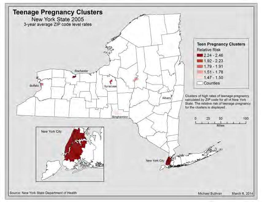
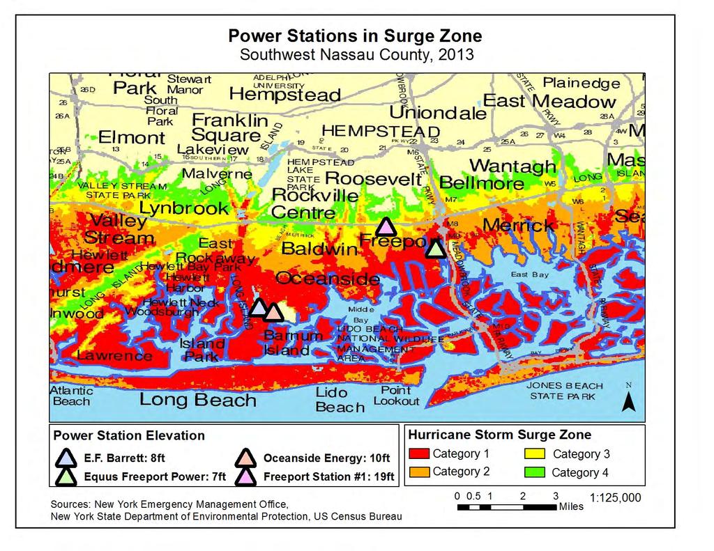
1 Michael Thomas Sullivan Home Address 2319 Brigham Street Brooklyn, NY Cell (516) Academic Address Geographic Information Science Dept. Lehman College, CUNY 250 Bedford Park Blvd. West Bronx, NY Education City University of New York Lehman College May, 2015 [anticipated] M.S. Geographic Information Science GPA: 3.6 Binghamton University, State University of New York May, 2013 B.S. Economics: Economic Policy Analysis GPA: 3.6 [cum laude] B.A. Geography: Urban and Regional Planning Professional Experience Cartographer Seneca Village Project, New York, NY May, 2014 Digitize & map archaeological data from 19 th c. site (NYC) GIS Intern NYC Dept. of Information Technology & Telecommunication, NYC, NY June Aug., 2014 Review data's adherence to maintenance procedures Identify geometry and attribute exceptions Assist in maintenance of geospatial databases Tutor / Lab Assistant GISc Lab [City University of New York - Lehman College], Bronx, NY Jan Present Teach/review GISc techniques to undergraduates/graduates - 6 hours/weekly Courses include Remote Sensing, Geo-spatial statistics, Natural Disasters and Environmental Health Student Mentor Johnson City Mentors Program [Binghamton University], Johnson City, NY Sep Dec Enabled 7 th grade mentee s academic, personal and social growth Assisted teachers to create a positive and productive learning environment Strategic Initiatives/Communications Intern MTA Capital Construction, New York, NY May 2012 Aug Conducted field study on progress of MTACC megaprojects Assisted Director in community outreach, media relations and internal communication Contributed to internal newsletters on MTACC affairs Led tour of East Side Access project for British Broadcasting Channel Lab Assistant Public Speaking Skills Lab, Binghamton, NY Dec May 2012 Observed public presentation and work with speaker to improve skills Created informational resources for students to access on lab website Planning Intern Vision Long Island, Northport NY May Aug. 2011; Dec Jan Collected and analyzed data for Downtown Profiling Project & Oct. Nov Surveyed and corresponded with owners in Small Business Administration Study Contributed 1 to 4 articles for weekly newsletter, Smart Talk Represented Vision at Nassau Chamber of Commerce meeting w/ NYS EDC Peer Mentor Emerging Leaders Program, Binghamton, NY Aug. Dec Developed new students leadership skills through service learning project Experience: ArcGIS, Idrisi, GeoDa, Remote Sensing, Statistical Package for the Social Sciences, R Statistical Software, Python Programming, Cost Benefit Analysis, Microsoft Excel (Problem Simulation and Optimization), Microsoft Office. Skills Academic Distinctions Presentations: Am. Psych. Assoc. Convention (Toronto, ON, 2009); Nat l Assoc. for Ethnic Studies Conference (Claremont, CA, 2011); Middle States Division, Assoc. of Am. Geographers Meeting (Union, NJ, 2011); New England-St. Lawrence Valley Geographical Society Conference (Worcester, MA, 2013); Urban History Assoc. Conference (Philadelphia, PA, 2014) Awards: Intel Science Talent Search Semi-Finalist, 2009; Coca-Cola Scholars Foundation Regional Scholar, 2009; Sodexo Foundation Stop Hunger Scholarship, 2010; Dept. of Defense SMART [Science, Mathematics And Research for Transformation] Scholarship Semi-Finalist, 2010; Smart Kids with Learning Disabilities Youth Achievement Award, 2009; Binghamton University- Sodexo Foundation Internship Program Grant, Publications: M. T. Sullivan, J. Strauss & D. S. Friedman (2012). Football discipline as a barometer of racism in English sport & society, : Spatial dimensions, Middle States Geographer, (45) pp ; D. Friedman, Y. Klein, J. Pillich & M. T. Sullivan (forthcoming). Sustainability planning, environmental justice and climate change: Applications of the Long Island MARKAL model, Journal of Suburban Sustainability
2 Michael Thomas Sullivan Sample Maps Sample Map 1 prepared for GEP 610: Spatial Analysis of Urban Health Sample Map 2 prepared for GEP 630: Geostatistics and Spatial Analytical Concepts Sample Map 3 prepared for D. Friedman, Y. Klein, J. Pillich & M. T. Sullivan (forthcoming). Sustainability planning, environmental justice and climate change: Applications of the Long Island MARKAL model, Journal of Suburban Sustainability.
3 Park Accessibility and the Impact on Exercise Manhattan Block Group Distance to Nearest Public Park Monthly Exercise Rate by UHF Zone Block Group Population Block Group Park Accessibility Population Public Parks Park Accessibility Distance to Nearest Park High (=< 1/8 Mile) Medium (1/8-1/4 Mile) Low (> 1/4 Mile) No Data Using Block Groups and Manhattan Pedestrian Streets, distance to nearest public park was calculated, using a road network. Park accessibility, an environmental good, is linked with health and well-being. Populations with high accessibility to public parks could see health benefits.the inability to detect indiviudalized park accessibility limits this analysis. Aggregated units like Block Groups do no detect where individuals are located. Individuals are opposite ends of the unit may have different park accessibility in reality, but are assigned the same accessibility in analysis Miles Percent of Population Exercised in Last 30 Days Average Distance to Nearest Park (Feet) Using the determined distance to the nearest park and Block Group populations, a population weighted average distance to the nearest park was calculated for United Hospital Fund (UHF) Zones in Manhattan. The UHF Zone park accessibility was compared to UHF Zone exercise rates, percent of population exercising in last 30 days. It is assumed that with increased park accessibility, more people would exercise. This result was not found. Instead it was 87.1 seen that exercise rate decreased with increased accessibility Correlation: Exercise vs. Distance to Park: The correlation of exercise and distance to the nearest park shows that with a 1% increase in the distance to the nearest park, there is a.3% increase in the percent of population exercising in the last 30 days. This result couldbe due to the inaccuracies in determining individualized park accessibility or due to the small sample size of the UHF Zones, Sources: 1. NYC Dept. of Health and Mental Hygiene: Manhattan UHF Zones 2. NYC Dept. of Parks and Rec.; Manhattan Boro Outline, Manhattan Parks, Manhattan Park Access Points 3. NYC Dept. of Planning: Manhattan Streets 4. US Census: Block Groups with Population Michael Sullivan 3/18/2014
4
5
Hayward, P. (2007). Mexican-American assimilation in U.S. metropolitan areas. The Pennsylvania Geographer, 45(1), 3-15.
. Mexican-American assimilation in U.S. metropolitan areas. The Pennsylvania Geographer, 45(1), 3-15.") PETER HAYWARD Assistant Professor of Geography and GIS Faculty Fellow SUNY College at Oneonta 323 Milne Library Oneonta, NY 13820 Phone: 607-436-3398 Email: haywarpm@oneonta.edu Web: http://employees.oneonta.edu/haywarpm
PETER HAYWARD Assistant Professor of Geography and GIS Faculty Fellow SUNY College at Oneonta 323 Milne Library Oneonta, NY 13820 Phone: 607-436-3398 Email: haywarpm@oneonta.edu Web: http://employees.oneonta.edu/haywarpm
COLLEGE OF PUBLIC AFFAIRS AND COMMUNITY SERVICE School of Public Administration Emergency Services Program Bachelor of Science in Emergency Management
 COLLEGE OF PUBLIC AFFAIRS AND COMMUNITY SERVICE School of Public Administration Emergency Services Program Bachelor of Science in Emergency Management (2015/2016 Catalog) Emergency Management develops
Joanne N. Halls, PhD Dept. of Geography & Geology David Kirk Information Technology Services
 Joanne N. Halls, PhD Dept. of Geography & Geology David Kirk Information Technology Services Geographic Information Systems manage and analyze data to solve spatial problems. Real World Abstraction Analysis
Geographic Systems and Analysis
 Geographic Systems and Analysis New York University Robert F. Wagner Graduate School of Public Service Instructor Stephanie Rosoff Contact: stephanie.rosoff@nyu.edu Office hours: Mondays by appointment
GeoHealth Applications Platform ESRI Health GIS Conference 2013
 GeoHealth Applications Platform ESRI Health GIS Conference 2013 Authors Thomas A. Horan, Ph.D. Professor, CISAT Director April Moreno Health GeoInformatics Ph.D. Student Brian N. Hilton, Ph.D. Clinical
LEHMAN COLLEGE OF THE CITY UNIVERSITY OF NEW YORK. 1. Type of Change: Change in Degree Requirements
 Alpha Number: Hegis Code 1214 Program Code: 30600 1. Type of Change: Change in Degree Requirements 2. From: [The curriculum consists of 45 graduate credits and includes core courses, an area of specialization,
Curriculum Vitae. Dr. Danqing (Dana) Xiao. Ph.D. in Department of Geography, University of California Santa Barbara.
 Xiao. Ph.D. in Department of Geography, University of California Santa Barbara.") Curriculum Vitae Dr. Danqing (Dana) Xiao Personal Information Assistant Professor Department of Environmental, Geographical, and Geological Sciences (EGGS), Bloomsburg University of Pennsylvania Research
Curriculum Vitae Dr. Danqing (Dana) Xiao Personal Information Assistant Professor Department of Environmental, Geographical, and Geological Sciences (EGGS), Bloomsburg University of Pennsylvania Research
The Changing Face of Geospatial Technology
 The Changing Face of Geospatial Technology Vincent A. DiNoto, Jr. Director of GeoTech Center Vince.dinoto@kctcs.edu Based upon work supported by the National Science Foundation under Grant DUE ATE 1304591.
Esri and GIS Education
 Esri and GIS Education Organizations Esri Users 1,200 National Government Agencies 11,500 States & Regional Agencies 30,800 Cities & Local Governments 32,000 Businesses 8,500 Utilities 12,600 NGOs 11,000
11/3/17. PSYC 100 discussion sessions can help you explore some of these possibilities! What can I do with my degree? Non-Linear Career Path
 PSYC 100 discussion sessions can help you explore some of these possibilities! What can I do with my degree? Credit: Celeste Spier, former UNL psychology advisor } I won t get a job after I graduate. }
LEHMAN COLLEGE CITY UNIVERSITY OF NEW YORK DEPARTMENT OF ENVIRONMENTAL, GEOGRAPHIC, AND GEOLOGICAL SCIENCES CURRICULAR CHANGE
 LEHMAN COLLEGE CITY UNIVERSITY OF NEW YORK DEPARTMENT OF ENVIRONMENTAL, GEOGRAPHIC, AND GEOLOGICAL SCIENCES CURRICULAR CHANGE Hegis Code: 2206.00 Program Code: 452/2682 1. Type of Change: New Course 2.
Subway Station Entrances, New York NY, May 2016
 Page 1 of 6 Metadata format: ISO 19139 Subway Station Entrances, New York NY, May 2016 ISO 19139 metadata content Resource Identification Information Spatial Representation Information Reference System
BIG IDEAS. Area of Learning: SOCIAL STUDIES Urban Studies Grade 12. Learning Standards. Curricular Competencies
 Area of Learning: SOCIAL STUDIES Urban Studies Grade 12 BIG IDEAS Urbanization is a critical force that shapes both human life and the planet. The historical development of cities has been shaped by geographic,
Creating a Staff Development Plan with Esri
 Creating a Staff Development Plan with Esri Michael Green David Schneider Guest Presenter: Shane Feirer, University of California Esri UC 2014 Technical Workshop Agenda What is a Staff Development Plan?
Express Bus Stops, New York NY, Nov 2018
 Metadata format: ISO 19139 Express Bus Stops, New York NY, Nov 2018 ISO 19139 metadata content Resource Identification Information Spatial Representation Information Reference System Information Data Quality
Medical GIS: New Uses of Mapping Technology in Public Health. Peter Hayward, PhD Department of Geography SUNY College at Oneonta
 Medical GIS: New Uses of Mapping Technology in Public Health Peter Hayward, PhD Department of Geography SUNY College at Oneonta Invited research seminar presentation at Bassett Healthcare. Cooperstown,
Oman NSDI Business Values and Future Directions. Hassan Alawi Alghazali Acting Director General National Spatial Data Infrastructure
 Oman NSDI Business Values and Future Directions Hassan Alawi Alghazali Acting Director General National Spatial Data Infrastructure Presentation Outline Geospatial Maturity Current Challenges NCSI s Role
GIS FOR PLANNING. Course Overview. Schedule. Instructor. Prerequisites. Urban Planning 792 Thursday s 5:30-8:10pm SARUP 158
 GIS FOR PLANNING Urban Planning 792 Thursday s 5:30-8:10pm SARUP 158 Schedule Class/Lab - SARUP 158 Thursdays 5:30pm - 8:10pm Office Hours - By Appointment Project Ideas - Week 4 Final - 5/10/2018 Instructor
Oman NSDI Supporting Economic Development. Saud Al-Nofli Director of Spatial Data Directorate General of NSDI, NCSI
 Oman NSDI Supporting Economic Development 2017 Saud Al-Nofli Director of Spatial Data Directorate General of NSDI, NCSI "It s critical to make correct decisions the first time to optimize the Investments
LIRR Routes, New York NY, January 2017
 Page 1 of 6 Metadata format: ISO 19139 LIRR Routes, New York NY, January 2017 ISO 19139 metadata content Resource Identification Information Spatial Representation Information Reference System Information
Staten Island Bus Stops, New York NY, May 2016
 Page 1 of 6 Metadata format: ISO 19139 Staten Island Bus Stops, New York NY, May 2016 ISO 19139 metadata content Resource Identification Information Spatial Representation Information Reference System
geographic patterns and processes are captured and represented using computer technologies
 Proposed Certificate in Geographic Information Science Department of Geographical and Sustainability Sciences Submitted: November 9, 2016 Geographic information systems (GIS) capture the complex spatial
Labs: Chelsea Ackroyd Office Location: FMAB 005 Office Hours: M 08:45 11:45 AM or by appointment
 Introduction to Geographic Information Systems (GEOG 3140 and 314) & GIS Fundamentals (GEOG 6139) Fall 2017 Section 002 M 01:25 02:45 PM Section 003 M 03:00 4:20 PM Section 004 W 01:25 02:45 PM M Lib 1150
GIS = Geographic Information Systems;
 What is GIS GIS = Geographic Information Systems; What Information are we talking about? Information about anything that has a place (e.g. locations of features, address of people) on Earth s surface,
THE UNIVERSITY OF HONG KONG FACULTY OF SOCIAL SCIENCES
 THE UNVERSTY OF HONG KONG FACULTY OF SOCAL SCENCES Courses offered to Exchange/Visiting Students in the 2013-2014 Academic Year For course details, please refer to the Departmental Link Department of Geography
International Development
 International Development Office: The Payson Center for International Development and Technology Transfer, 300 Hébert Hall Phone: 504-865-5240 Fax: 504-865-5241 Website: www.payson.tulane.edu/ Program
2018 ESRI Education Summit. San Diego. California. Sunday July 8 th 2018 Harper College, Palatine, Illinois, USA Dr. Tong Cheng (Biology), Dr.
, Dr.") 2018 ESRI Education Summit. San Diego. California. Sunday July 8 th 2018 Harper College, Palatine, Illinois, USA Dr. Tong Cheng (Biology), Dr. James Gramlich (Sociology), Mukila Maitha (Geography), Dr.
2018 ESRI Education Summit. San Diego. California. Sunday July 8 th 2018 Harper College, Palatine, Illinois, USA Dr. Tong Cheng (Biology), Dr. James Gramlich (Sociology), Mukila Maitha (Geography), Dr.
Geog418: Introduction to GIS Fall 2011 Course Syllabus. Textbook: Introduction to Geographic Information Systems edited by Chang (6th ed.
 Geog418: Introduction to GIS Fall 2011 Course Syllabus AH 1320 3:30 4:45 p.m.tr Instructor: Dr. Shunfu Hu Office: AH1413 Telephone 650-2281 Office hours: 10:00 11:00 a.m. TR or by appointment (shu@siue.edu)
Bus Routes, New York NY, August 2017
 Page 1 of 6 Metadata format: ISO 19139 Bus Routes, New York NY, August 2017 ISO 19139 metadata content Resource Identification Information Spatial Representation Information Reference System Information
Economic Geography of the Long Island Region
 Geography of Data Economic Geography of the Long Island Region Copyright 2011 AFG 1 The geography of economic activity requires: - the gathering of spatial data - the location of data geographically -
GIST 4302/5302: Spatial Analysis and Modeling
 GIST 4302/5302: Spatial Analysis and Modeling Fall 2015 Lectures: Tuesdays & Thursdays 2:00pm-2:50pm, Science 234 Lab sessions: Tuesdays or Thursdays 3:00pm-4:50pm or Friday 9:00am-10:50am, Holden 204
LIRR Routes, New York NY, May 2016
 Page 1 of 6 Metadata format: ISO 19139 LIRR Routes, New York NY, May 2016 ISO 19139 metadata content Resource Identification Information Spatial Representation Information Reference System Information
GIS Education Activities in Detroit Public Schools Preparing Students for Careers in the Geospatial Industry A Multi-Agency Collaboration
 GIS Education Activities in Detroit Public Schools Preparing Students for Careers in the Geospatial Industry A Multi-Agency Collaboration Marsha A. Lewis, Social Studies Curriculum Specialist, Detroit
Introduction to GIS (GEOG 401) Spring 2014, 3 credit hours
 Spring 2014, 3 credit hours") Introduction to GIS (GEOG 401) Spring 2014, 3 credit hours Instructors: Guangxing Wang, Ph.D. Email: gxwang@siu.edu Phone: (618) 453-6017 Office: 4442 Faner Hall Office hours: M& W&F 9:00am-11:00am or
Introduction to GIS (GEOG 401) Spring 2014, 3 credit hours Instructors: Guangxing Wang, Ph.D. Email: gxwang@siu.edu Phone: (618) 453-6017 Office: 4442 Faner Hall Office hours: M& W&F 9:00am-11:00am or
The B.S.G.E. program is accredited by the Engineering Accreditation Commission of ABET,
 Geomatics Engineering The program of study leading to the Bachelor of Science in Geomatics Engineering (B.S.G.E.) deals with designing solutions to measure, map, model, analyze and graphically display
BROOKINGS May
 Appendix 1. Technical Methodology This study combines detailed data on transit systems, demographics, and employment to determine the accessibility of jobs via transit within and across the country s 100
OISS Statistical Report
 Enrollment by College, Major, and Level College of Agriculture & Natural Resources Ag, Food & Resource Economics 40 0 0 40 Agr & Nat Res - No Preference 0 0 3 3 Agribusiness Management 0 0 22 22 Agricultural
CURRICULUM VITAE Mthobeli Vaaltyn
 CURRICULUM VITAE Mthobeli Vaaltyn 2880 Dwarhane Street Browns Farm Philippi 7785 Cell: 071 3720 456 E-Mail: mvaaltyn4@gmail.com PERSONAL DETAILS Surname First Name(s) : Vaaltyn : Mthobeli Date of Birth
Alleghany County Schools Curriculum Guide GRADE/COURSE: World Geography
 GRADE/COURSE: World 2013-14 GRADING PERIOD: 1 st Six Weeks Time Frame Unit/SOLs SOL # Strand Resource Assessment 8 days* The student will use maps, globes, satellite images, photographs, or diagrams to
Spatial Web Technology for Urban Green Society (A Case of Tsukuba City)
") The 5th Japan-Korea-China Joint Conference on Geography (Green Society in East Asia: A Geographical Contribution) Spatial Web Technology for Urban Green Society (A Case of Tsukuba City) Ko Ko Lwin and
The 5th Japan-Korea-China Joint Conference on Geography (Green Society in East Asia: A Geographical Contribution) Spatial Web Technology for Urban Green Society (A Case of Tsukuba City) Ko Ko Lwin and
PLANNING (PLAN) Planning (PLAN) 1
 Planning (PLAN) 1") Planning (PLAN) 1 PLANNING (PLAN) PLAN 500. Economics for Public Affairs Description: An introduction to basic economic concepts and their application to public affairs and urban planning. Note: Cross-listed
Planning (PLAN) 1 PLANNING (PLAN) PLAN 500. Economics for Public Affairs Description: An introduction to basic economic concepts and their application to public affairs and urban planning. Note: Cross-listed
Massachusetts Institute of Technology Department of Urban Studies and Planning
 Massachusetts Institute of Technology Department of Urban Studies and Planning 11.204: Planning, Communications & Digital Media Fall 2002 Lecture 6: Tools for Transforming Data to Action Lorlene Hoyt October
A Street Named for a King
 A Street Named for a King Dr. Jerry Mitchell University of South Carolina OVERVIEW This lesson adapts the work of Dr. Derek Alderman, a geographer who has used the Martin Luther King, Jr. street-naming
Nurture Nature Center Receives Grant From National Oceanic and Atmospheric Administration To Study Flood Forecast and Warning Tools
 Nurture Nature Center Receives Grant From National Oceanic and Atmospheric Administration To Study Flood Forecast and Warning Tools One of four national awards by National Weather Service to advance weather
Developing a Tactical-Level Geospatial Course for Army Engineers
 Developing a Tactical-Level Geospatial Course for Army Engineers Jared L. Ware Geospatial Information Science Program Department of Geography and Environmental Engineering United States Military Academy
GEOG 508 GEOGRAPHIC INFORMATION SYSTEMS I KANSAS STATE UNIVERSITY DEPARTMENT OF GEOGRAPHY FALL SEMESTER, 2002
 GEOG 508 GEOGRAPHIC INFORMATION SYSTEMS I KANSAS STATE UNIVERSITY DEPARTMENT OF GEOGRAPHY FALL SEMESTER, 2002 Course Reference #: 13210 Meeting Time: TU 2:05pm - 3:20 pm Meeting Place: Ackert 221 Remote
NEW YORK DEPARTMENT OF SANITATION. Spatial Analysis of Complaints
 NEW YORK DEPARTMENT OF SANITATION Spatial Analysis of Complaints Spatial Information Design Lab Columbia University Graduate School of Architecture, Planning and Preservation November 2007 Title New York
Mutah university faculty of Social Sciences The Study plan of the department of Geography 2006/2007
 Mutah university faculty of Social Sciences The Study plan of the department of Geography 2006/2007 Requirements university compulsory 22 Credit hours Course No Credit hours Prerequisite Requirements Faculty
Integrating Official Statistics and Geospatial Information NBS Experience
 Integrating Official Statistics and Geospatial Information NBS Experience Presented by Eng. Reda AL Sabbagh Director of IT Dept. Prepared by Eng. Adham Makky GIS Specialist Topics to be covered: Background
Department of Geography
 Department of (College of Social and Behavioral Sciences) www.uni.edu/geography The Department of offers the following undergraduate and graduate programs and program certificate. Specific requirements
GIS BASED ANALYSIS OF EXPRESS VS LOCAL STATIONS ON SURROUNDING LAND USES IN NEW YORK CITY
 GIS BASED ANALYSIS OF EXPRESS VS LOCAL STATIONS ON SURROUNDING LAND USES IN NEW YORK CITY GIS in Transit Conference, Washington D.C Date: September 2, 2015 1 Subrina Rahman Supervised by Dr. Candace Brakewood
MASTER OF APPLIED GEOGRAPHY (M.A.GEO.) MAJOR IN GEOGRAPHIC INFORMATION SCIENCE
 MAJOR IN GEOGRAPHIC INFORMATION SCIENCE") Master of Applied Geography (M.A.Geo.) Major in Geographic Information Science 1 MASTER OF APPLIED GEOGRAPHY (M.A.GEO.) MAJOR IN GEOGRAPHIC INFORMATION SCIENCE Major Program The Master of Applied Geography
Master of Applied Geography (M.A.Geo.) Major in Geographic Information Science 1 MASTER OF APPLIED GEOGRAPHY (M.A.GEO.) MAJOR IN GEOGRAPHIC INFORMATION SCIENCE Major Program The Master of Applied Geography
MASTER OF APPLIED GEOGRAPHY (M.A.GEO.) MAJOR IN GEOGRAPHY RESOURCE AND ENVIRONMENTAL STUDIES
 MAJOR IN GEOGRAPHY RESOURCE AND ENVIRONMENTAL STUDIES") Master of Applied Geography (M.A.Geo.) Major in Geography Resource and Environmental Studies 1 MASTER OF APPLIED GEOGRAPHY (M.A.GEO.) MAJOR IN GEOGRAPHY RESOURCE AND ENVIRONMENTAL STUDIES Major Program
Master of Applied Geography (M.A.Geo.) Major in Geography Resource and Environmental Studies 1 MASTER OF APPLIED GEOGRAPHY (M.A.GEO.) MAJOR IN GEOGRAPHY RESOURCE AND ENVIRONMENTAL STUDIES Major Program
Lab Assistant: Kathy Tang Office: SSC 2208 Phone: ext
 The University of Western Ontario Department of Geography GEOGRAPHY 9110B: Introduction to Geographic Information Systems Lecture: Thursday 11:30 1:30pm, SSC #1004 Lab: Thursday 2:30 4:30pm, SSC #1316A
CUNY Tax Lots, New York NY, Sept 2016
 Page 1 of 6 Metadata format: ISO 19139 CUNY Tax Lots, New York NY, Sept 2016 ISO 19139 metadata content Resource Identification Information Spatial Representation Information Reference System Information
UN-GGIM: Strengthening Geospatial Capability
 Fifth Plenary Meeting of UN-GGIM: Europe Brussels, 6-7 June 2018 UN-GGIM: Strengthening Geospatial Capability Walking the talk to leave no one behind Greg Scott, UN-GGIM Secretariat Environmental Statistics
Department of Geosciences
 Department of Geosciences Department of Geosciences Department Head: Dr. John Rodgers Office: 08 Hilbun Undergraduate Coordinator: Dr. Andrew Mercer Academic Coordinator: Tina Davis B.S. and M.S. degrees
BACHELOR OF ARTS GEOGRAPHY
 BACHEL OF ARTS General Education Categories (4-5 credits total) FYS First Year Seminar W-I Written Communication - Level I OC Oral Communication PGR Personal Growth & Responsibility CEA Creative Expression
Lower Density Growth Management Metadata
 Products > BYTES of the BIG APPLE TM Lower Density Growth Management Metadata nyldgma Data Format: Shapefile File or table name: nyldgma Data Projection: NAD_1983_StatePlane_New_York_Long_Island_FIPS_3104_Feet
Leveraging Interactive AJAX Web Tools for Online Maps
 Leveraging Interactive AJAX Web Tools for Online Maps Presentation at GeoWeb 2009 Academic Track Steven Romalewski CUNY Mapping Service The Graduate Center / City University of New York July 2009 1 The
GIS PORTFOLIO MOHAMED MAGDY MOHAMED HUSSAIN GIS ENGINEER. UWF GIS ONLINE CERTIFICATE GIS Internship (GIS4944)
") 2012 GIS PORTFOLIO MOHAMED MAGDY MOHAMED HUSSAIN GIS ENGINEER UWF GIS ONLINE CERTIFICATE GIS Internship (GIS4944) Portfolio Table of Contents Subject... Page Personal statement/mission/philosophy... 1
2012 GIS PORTFOLIO MOHAMED MAGDY MOHAMED HUSSAIN GIS ENGINEER UWF GIS ONLINE CERTIFICATE GIS Internship (GIS4944) Portfolio Table of Contents Subject... Page Personal statement/mission/philosophy... 1
GEOGRAPHY - B.A. Description. University Requirements. Admission Requirements. Fully Offered At: Kent State University Catalog
 Kent State University Catalog 208-209 GEOGRAPHY - B.A. College of Arts and Sciences Department of Geography 4 McGilvrey Hall Kent Campus 0-672-2045 geography@kent.edu www.kent.edu/geography Description
Understanding and accessing 2011 census aggregate data
 Understanding and accessing 2011 census aggregate data 4 July 11:00 to 16:00 BST Justin Hayes and Richard Wiseman UK Data Service Census Support UK censuses provide an unparalleled resource of high quality
HGP 470 GIS and Advanced Cartography for Social Science
 HGP 470 GIS and Advanced Cartography for Social Science Winter 2014 Instructor: Office: Tory 3-115 Telephone: 780-248-5758 E-mail: vukicevi@ualberta.ca Office hours: By appointment LECTURES AND LABS Lectures/Labs:
Geospatial information integration for city management and development in Rio de Janeiro
 Geospatial information integration for city management and Leandro Gomes Souza Geographer Luiz Roberto Arueira da Silva Director of City Information Pereira Passos Institute - City of Rio de Janeiro About
Proposal for Revision to the Geographic Information Systems (GIS) Academic Certificate Community College of Philadelphia.
 Academic Certificate Community College of Philadelphia.") Proposal for Revision to the Geographic Information Systems (GIS) Academic Certificate Community College of Philadelphia February 24, 2010 Kathy Smith Chair, Social Science Contributors Christopher Murphy
Proposal for Revision to the Geographic Information Systems (GIS) Academic Certificate Community College of Philadelphia February 24, 2010 Kathy Smith Chair, Social Science Contributors Christopher Murphy
Kenneth Melchert (Senior Statistician - Regional Liaison Officer)
") Sourcing Spatial Data from Local Government Getting the Data Right The Supplier s Perspective Presenter: Kenneth Melchert (Senior Statistician - Regional Liaison Officer) Information Products and Services
Sourcing Spatial Data from Local Government Getting the Data Right The Supplier s Perspective Presenter: Kenneth Melchert (Senior Statistician - Regional Liaison Officer) Information Products and Services
NEW YORK AND CONNECTICUT SUSTAINABLE COMMUNITIES. Fair Housing & Equity Assessment & Regional Planning Enhancement
 NEW YORK AND CONNECTICUT SUSTAINABLE COMMUNITIES Fair Housing & Equity Assessment & Regional Planning Enhancement November 19, 2013 White Plains Public Library Federal grant to improve regional planning
2 nd Semester. Core Courses. C 2.1 City and Metropolitan Planning. Module 1: Urban Structure and Growth Implications
 2 nd Semester Core Courses C 2.1 City and Metropolitan Planning Module 1: Urban Structure and Growth Implications Growth of cities; cities as engine of growth; urban sprawl; land value, economic attributes
Land Use in the context of sustainable, smart and inclusive growth
 Land Use in the context of sustainable, smart and inclusive growth François Salgé Ministry of sustainable development France facilitator EUROGI vice president AFIGéO board member 1 Introduction e-content+
Department of Geosciences
 Department of Geosciences Department of Geosciences Interim Department Head: Dr. John Rodgers Office: 08 Hilbun Undergraduate Coordinator: Dr. Andrew Mercer Academic Coordinator: Tina Davis B.S. and M.S.
Application of Geospatial Technology in an Emergency Management Academic Program
 Application of Geospatial Technology in an Emergency Management Academic Program Author Edwin Leachman Visiting Assistant Professor Department of Emergency Administration and Management Arkansas Tech University
1. Omit Human and Physical Geography electives (6 credits) 2. Add GEOG 677:Internet GIS (3 credits) 3. Add 3 credits to GEOG 797: Final Project
 2. Add GEOG 677:Internet GIS (3 credits) 3. Add 3 credits to GEOG 797: Final Project") The Department of Geography and the Office of Professional Studies propose to modify the Master of Professional Studies in Geospatial Information Sciences (GIS) as follows: 1. Omit Human and Physical Geography
The Department of Geography and the Office of Professional Studies propose to modify the Master of Professional Studies in Geospatial Information Sciences (GIS) as follows: 1. Omit Human and Physical Geography
Techniques for Science Teachers: Using GIS in Science Classrooms.
 Techniques for Science Teachers: Using GIS in Science Classrooms. After ESRI, 2008 GIS A Geographic Information System A collection of computer hardware, software, and geographic data used together for
About WE RE A PASSIONATE COMPANY FILLED WITH PASSIONATE INDIVIDUALS OUR MISSION OUR VISION OUR TAGLINE OUR NAME
 Media Kit About For more than 65 years, The Arc Northern Chesapeake Region (The Arc NCR) has helped people with intellectual and developmental disabilities to live, work and play in Harford and Cecil Counties.
Spatial analysis of locational conflicts
 Spatial analysis of locational conflicts Case study: Locational conflicts generated by the expansion of built up surfaces in the northern area of Bucharest, Romania Diana A. ONOSE 1, Cristian I. IOJĂ 2,
Geography and Geographic Information Science (Geog)
") University of North Dakota 1 Geography and Geographic Information Science (Geog) http://www.arts-sciences.und.edu/geography Atkinson, Munski (Graduate Director), Niedzielski, Rundquist, Todhunter, Vandeberg
University of North Dakota 1 Geography and Geographic Information Science (Geog) http://www.arts-sciences.und.edu/geography Atkinson, Munski (Graduate Director), Niedzielski, Rundquist, Todhunter, Vandeberg
Curriculum Vita. Timothy J. Niblett
 Curriculum Vita Timothy J. Niblett CONTACT DETAILS 3416 Bellevue Drive Modesto, CA 95350 tniblett@ucsb.edu (209) 480-0467 EDUCATION Ph.D M.A. M.A. B.A. 2016, University of California at Santa Barbara (Geography)
Compact guides GISCO. Geographic information system of the Commission
 Compact guides GISCO Geographic information system of the Commission What is GISCO? GISCO, the Geographic Information System of the COmmission, is a permanent service of Eurostat that fulfils the requirements
PROFESSIONAL-CLERICAL RATIO REPORT
 PROFESSIONAL-CLERICAL RATIO REPORT UNIVERSITY OF HAWAI I FY 2005-06 University Budget Office University of Hawai i September 2006 File Reference: Management and Planning Support Folder, Courses Reports
The Attractive Side of Corpus Christi: A Study of the City s Downtown Economic Growth
 The Attractive Side of Corpus Christi: A Study of the City s Downtown Economic Growth GISC PROJECT DR. LUCY HUANG SPRING 2012 DIONNE BRYANT Introduction Background As a GIS Intern working with the City
COURSE INTRODUCTION & COURSE OVERVIEW
 week 1 COURSE INTRODUCTION & COURSE OVERVIEW topics of the week Instructor introduction Students introductions Course logistics Course objectives Definition of GIS The story of GIS introductions Who am
Rural Louisiana. A quarterly publication of the Louisiana Tech Rural Development Center
 Rural Louisiana A quarterly publication of the Louisiana Tech Rural Development Center Volume 4, No. 1, Fall 2009 Editor: Aaron K. Lusby Director, Asst. Professor Newsletter design: Stephanie Tidwell Student
JOB DESCRIPTION. Research Associate - Urban Economy and Employment
 JOB DESCRIPTION Research Associate - Urban Economy and Employment 2 Research Associate Urban Economy and Employment About Us The Indian Institute for Human Settlements (IIHS) is a national education institution
YORK UNIVERSITY - UNIVERSITÉ YORK
 Faculty of Liberal Arts and Professional Studies Administrative Studies 1,538 1,323 336 309 3,506 0 0 1 0 1 African Studies 0 0 0 0 0 3 6 2 3 14 Anthropology 49 90 9 30 178 0 0 0 0 0 Applied Mathematics
DRAFT OCTOBER 2008 LETTER OF INTENT
 DRAFT OCTOBER 2008 LETTER OF INTENT LEHMAN COLLEGE OF THE CITY UNIVERSITY OF NEW YORK MASTER S PROGRAM IN GEOGRAPHIC INFORMATION SCIENCE (MGISc) DEPARTMENT OF ENVIRONMENTAL, GEOGRAPHIC AND GEOLOGICAL SCIENCES
GEOGRAPHY (GE) Courses of Instruction
 Courses of Instruction") GEOGRAPHY (GE) GE 102. (3) World Regional Geography. The geographic method of inquiry is used to examine, describe, explain, and analyze the human and physical environments of the major regions of the
GEOGRAPHY (GE) GE 102. (3) World Regional Geography. The geographic method of inquiry is used to examine, describe, explain, and analyze the human and physical environments of the major regions of the
SUMMARY OF DEGREES GRANTED Indiana University - Purdue University Fort Wayne
 SUMMARY OF DEGREES GRANTED Indiana University - Purdue University Fort Wayne 2001-2002 Reported as of July 1, 2002 Prepared by Office of Institutional Research May, 2001 May, 2002 Change % Change Indiana
GCSE GEOGRAPHY. Your guide to GCSE St. Richard s Catholic College
 GCSE GEOGRAPHY Your guide to GCSE Geography @ St. Richard s Catholic College A Geographer s way of thinking Caring for the environment Understand cultural differences Understand and explore worldwide disasters
Diffusion of GIS in Public Policy Doctoral Program
 Diffusion of GIS in Public Policy Doctoral Program By Fulbert Namwamba PhD Southern University This presentation demonstrate how GIS was introduced in the Public Policy Doctoral Program at Southern University,
HGP 470 GIS and Advanced Cartography in Social Science
 HGP 470 GIS and Advanced Cartography in Social Science Fall 2012 Instructor: Dr Sinisa J. Vukicevic Office: Tory 3-115 Telephone: 780-248-5758 E-mail: vukicevi@ualberta.ca Office hours: Wednesday 10:00
"GIS-Sofia" Ltd. geospatial data integration in SOFCAR geographic information system and providing services March 2018, Sofia
 "GIS-Sofia" Ltd. geospatial data integration in SOFCAR geographic information system and providing services Geographical Information System Sofia " Ltd....the beginning... Established in 1999, as a Sofia
GIST 4302/5302: Spatial Analysis and Modeling
 GIST 4302/5302: Spatial Analysis and Modeling Spring 2014 Lectures: Tuesdays & Thursdays 2:00pm-2:50pm, Holden Hall 00038 Lab sessions: Tuesdays or Thursdays 3:00pm-4:50pm or Wednesday 1:00pm-2:50pm, Holden
PERCEPTION and Focus on Maps. Focus on Maps 8/29/2014. English and Dutch Maps from the 1600s and 1680 British Maps of N. Am.
 PERCEPTION English and Dutch Maps from the 600s The Nature of New York Dutch67 Prof. Anthony Grande English 67 Copyright 04 AFG 676 and 680 British Maps of N. Am. 70 and 776 4 Focus on Maps Maps are geographers
Jeanette Eckert. September 22, 2015
 Jeanette Eckert September 22, 2015 Michigan State University Email: eckertj7@msu.edu Department of Geography Phone: 419-322-1454 673 Auditorium Road, Room 116 Website: www.msu.edu/~eckertj7 East Lansing,
The Establishment of a Database on Current Research in UNESCO Biosphere Reserves: Limitations and Opportunities
 The Establishment of a Database on Current Research in UNESCO Biosphere Reserves: Limitations and Opportunities Pamela Shaw a* Martin F. Price b Taylor Alexander a Rushi Gadoya a Graham Sakaki a Lauren
CK107 BA in Geographical and Archaeological Sciences
 CK107 BA in Geographical and Archaeological Sciences CK107 BA in Geographical and Archaeological Science Geography and Archaeology are closely related disciplines, concerned with concepts of time and space
Esri India User Conference
 Esri India User Conference The Leela Ambience Convention Hotel, Delhi January 19 20, 2017 Keynote Speaker Jack Dangermond Founder and President, Esri Inc. Register Today esriindia.com/indiauc About Esri
SUMMARY OF DEGREES GRANTED Indiana University - Purdue University Fort Wayne
 SUMMARY OF DEGREES GRANTED Indiana University - Purdue University Fort Wayne 2000-2001 Reported as of July 1, 2001 Prepared by Office of Institutional Research May, 2000 May, 2001 Change % Change Indiana
R E C O M M E N D E D B U D G E T FOR THE FISCAL YEAR BEGINNING SEPTEMBER 1, 2018
 R E C O M M E N D E D B U D G E T FOR THE FISCAL YEAR BEGINNING SEPTEMBER 1, 2018 Sam Houston State University Fiscal Year 2019 Operating Budget Table of Contents Schedules of Budgeted Revenues, Transfers