Leveraging Interactive AJAX Web Tools for Online Maps
|
|
|
- Elfrieda Mitchell
- 6 years ago
- Views:
Transcription
1 Leveraging Interactive AJAX Web Tools for Online Maps Presentation at GeoWeb 2009 Academic Track Steven Romalewski CUNY Mapping Service The Graduate Center / City University of New York July

2 The Challenge The Long Island Index wants to show (among other things): 1. Transit connections between where people live and where they work across Nassau and Suffolk counties; 2. Long Island s downtowns in relation to multi-family housing density plus access to parks and open space; 3. The communities with the highest proportion of multi-family units compare with regional views of age of housing stock; 4. Income attributes of any given community plus its concentration of rental units; 5. Brownfield locations compared with population patterns by race/ethnicity; 6. All of this and more with aerial photography on a map, all at once, interactively, online. GeoWeb 2009 CUNY Mapping Service 2


3 Mapping Multivariate Data Some traditional cartographic techniques Multiple symbol types Small multiples Multivariate dot density maps Different textures Transparency (eg., color coded DEM draped over hillshade) GeoWeb 2009 CUNY Mapping Service 3

4 Map display on the desktop Integrates many of the multivariate approaches GeoWeb 2009 CUNY Mapping Service 4

5 Map display on the desktop Also can leverage emerging geostatistical software packages with multi-framed display of integrated data Data_Mining_in_GeoVISTA_Studio.pdf GeoWeb 2009 CUNY Mapping Service 5

6 Map display on the desktop But How does this translate online? GeoWeb 2009 CUNY Mapping Service 6
7 Online map display PROs Interactive Zoom in very close or out very far with ease Add or remove layers of data from the map Slippy maps easy to navigate CONs Single frame generally rules out small multiples Multiple symbol types (including dot density and texture) generally don t translate well for thematic/analytical maps o but they can work well overlaying roads with choropleths, for example Transparencies would work, but until recently the cumbersome nature of webpage redraws makes this clunky Also, challenge of keeping it simple while making GIS analytic tools accessible GeoWeb 2009 CUNY Mapping Service 7
 o No need to click on a i tool to access attributes, or click a hand tool to pan the map, for example Open Source movement rapidly making new tools more accessible, encouraging")
8 Enter AJAX, applied to online maps Online mapping in a post-google Maps world o Ease of use and intuitive display o Relatively easy integration of multiple data sets from disparate sources (ie, mashups) o No need to click on a i tool to access attributes, or click a hand tool to pan the map, for example Open Source movement rapidly making new tools more accessible, encouraging experimentation and early deployment o Geoserver & Mapserver, OpenLayers, etc ESRI also enhancing their toolkit o New ArcGIS Server tools caching, etc Some early adopters of innovative approaches: o GeoWeb 2009 CUNY Mapping Service 8
9 New York-area examples Early 2006, CUNY Mapping Service established with broad mandate help CUNY researchers and others leverage the power of GIS in their work, and continue developing cutting-edge interactive online mapping systems 1. Long Island Index project asked us to develop interactive mapping feature for o Index background needed to make complex issues more understandable to public (esp. to visualize inter-relationships and multi-level spatial patterns) and to engage people via the Web 2. A second project is a complete overhaul of the Open Accessible Space Information System (OASIS) website ( first created in early 2000 using ArcIMS in collaboration with ESRI, USDA Forest Service, and more than 40 local NGOs, public agencies, businesses, and individuals. GeoWeb 2009 CUNY Mapping Service 9
10 A hybrid geo stack Technology choice: combination of ESRI/Microsoft with open source JavaScript frameworks ArcGIS Desktop and ArcSDE/SQL Server to manage the data sources. ArcGIS Server to generate web map services from MXDs and generate cached tiles for selected map layers. OpenLayers consumes WMS resources, manages and displays the map layers, and provides map navigation tools. Dynamic data feeds are also provided via REST web services. Ext JS provides the overall web framework and enables us to relatively easily integrate AJAX-style tools such as dynamic transparencies. With the exception of the satellite/aerial photos, we host all map layers Simply too much data to simply mash it up with a basemap from Google Maps or Microsoft and we wanted cartographic control. GeoWeb 2009 CUNY Mapping Service 10


11 The Long Island Index interactive map visualize your community in new and powerful ways Map your village When you select a village: 1. It s highlighted in orange; 2. Local statistics and charts are displayed; and 3. The overview map shows where on LI you ve zoomed to


12 See population or housing patterns in and around your community

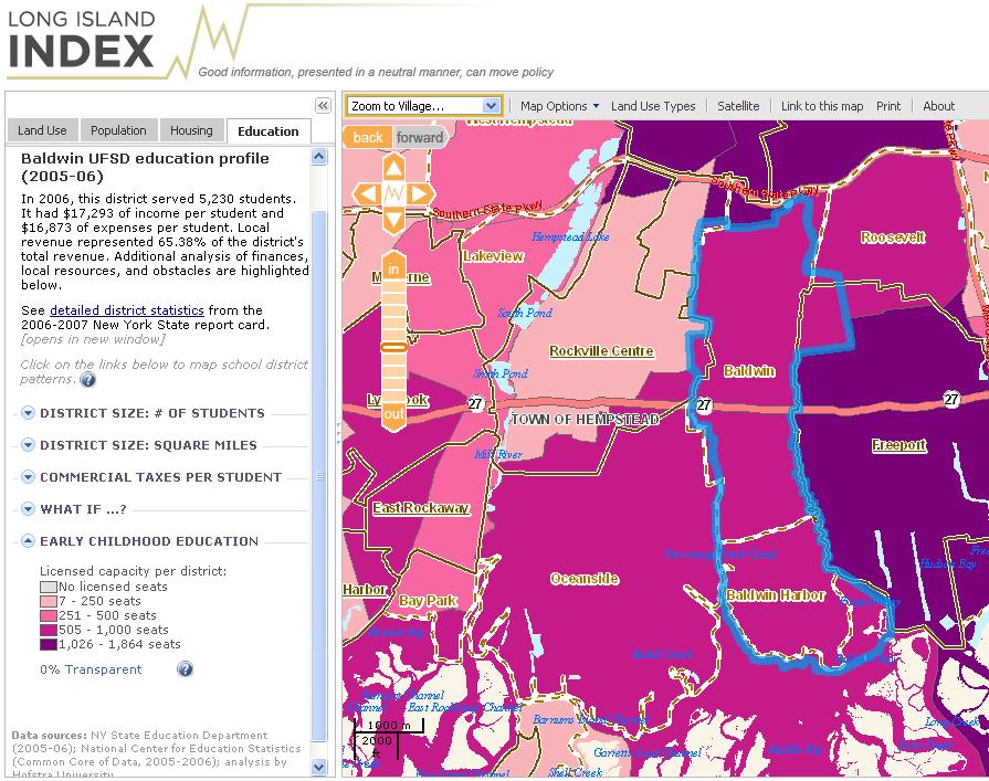
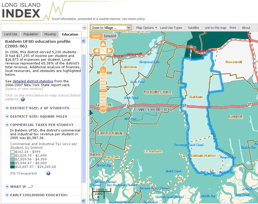
13 Map education statistics district-by-district NEW for 2009!

14 Add transportation routes, schools, environmental sites, special districts, and more


15 The transparency slider reveals what s underneath 0% transparent 50% transparent 100% transparent


16 Compare aerial photos with Census and land use patterns 0% transparent Click on the red marker for a bird s eye view 70% transparent 100% transparent


17 Explore regional views of key demographic indicators You can zoom out to see the entire island, and then double-click on the list to zoom back in and see community-level detail.
18 For more info, contact: Steven Romalewski, Director Phone: David Burgoon, Application Architect Phone: CUNY Mapping Service at the Center for Urban Research The Graduate Center / CUNY 365 Fifth Ave., Room 6202 New York, NY GeoWeb 2009 CUNY Mapping Service 18
Update and Modernization of Sales Tax Rate Lookup Tool for Public and Agency Users. David Wrigh
 Update and Modernization of Sales Tax Rate Lookup Tool for Public and Agency Users David Wrigh GIS at the Agency Introduction Who we are! George Alvarado, David Wright, Marty Parsons and Bob Bulgrien make
Leveraging the GIS Capability within FlexiCadastre
 Managing Local Land Concerns, Maintaining Corporate Governance Leveraging the GIS Capability within FlexiCadastre Regional User Conference, North America May 6 th May 9 th, 2013 Cameron McKellar, Technical
Google Maps and Beyond
 Google Maps and Beyond Aaron Paul First American Title apaul@firstam.com 2015 APRA Symposium Association of Professional Reserve Analysts May 2 nd, 2015 Google Maps and Beyond - Overview Business case
Local Government Basemaps using ArcGIS
 Local Government Basemaps using ArcGIS Steve Grisé Scott Oppmann Tuesday, July 14, 10:15-11:30am SDCC 30B Topics Basemaps for Local Government Essential Application-Driven New Ideas Design Strategies Discussion
Crime Analysis. GIS Solutions for Intelligence-Led Policing
 Crime Analysis GIS Solutions for Intelligence-Led Policing Applying GIS Technology to Crime Analysis Know Your Community Analyze Your Crime Use Your Advantage GIS aids crime analysis by Identifying and
Working with ArcGIS Online
 Esri International User Conference San Diego, CA Technical Workshops July 12, 2011 Working with ArcGIS Online Bern Szukalski, Deane Kensok Topics for this Session ArcGIS Online Overview ArcGIS Online Content
Write a report (6-7 pages, double space) on some examples of Internet Applications. You can choose only ONE of the following application areas:
 on some examples of Internet Applications. You can choose only ONE of the following application areas:") UPR 6905 Internet GIS Homework 1 Yong Hong Guo September 9, 2008 Write a report (6-7 pages, double space) on some examples of Internet Applications. You can choose only ONE of the following application
UPR 6905 Internet GIS Homework 1 Yong Hong Guo September 9, 2008 Write a report (6-7 pages, double space) on some examples of Internet Applications. You can choose only ONE of the following application
DATA APPLIANCE FOR ARCGIS
 DATA APPLIANCE FOR ARCGIS Data Appliance for ArcGIS Provides Access to Multi-Scale Basemaps Down to Medium Scale Levels Worldwide And Large Scale for Most of the World The Data Appliance includes Several
Geographic Systems and Analysis
 Geographic Systems and Analysis New York University Robert F. Wagner Graduate School of Public Service Instructor Stephanie Rosoff Contact: stephanie.rosoff@nyu.edu Office hours: Mondays by appointment
Rural Louisiana. A quarterly publication of the Louisiana Tech Rural Development Center
 Rural Louisiana A quarterly publication of the Louisiana Tech Rural Development Center Volume 4, No. 1, Fall 2009 Editor: Aaron K. Lusby Director, Asst. Professor Newsletter design: Stephanie Tidwell Student
ESRI Delivering geographic information systems to millions of users
 Using Web GIS to Track Government Spending and Performance Eric Floss - ESRI April 12, 2010 ESRI Delivering geographic information systems to millions of users GIS Is Changing Everything How We Reason
Getting Started with Community Maps
 Esri International User Conference San Diego, California Technical Workshops July 24, 2012 Getting Started with Community Maps Shane Matthews and Tamara Yoder Topics for this Session ArcGIS is a complete
Map Services Are We Getting It?
 Map Services Are We Getting It? Rich Herrmann VP Global Platforms & Technology, IHS James Sanders Senior Product Manager, IHS April 19, 2011 Houston, TX USA Overview The Challenge Keith Fraley s 2010 PUG
You are Building Your Organization s Geographic Knowledge
 You are Building Your Organization s Geographic Knowledge And Increasingly Making it Available Sharing Data Publishing Maps and Geo-Apps Developing Collaborative Approaches Citizens Knowledge Workers Analysts
Esri and GIS Education
 Esri and GIS Education Organizations Esri Users 1,200 National Government Agencies 11,500 States & Regional Agencies 30,800 Cities & Local Governments 32,000 Businesses 8,500 Utilities 12,600 NGOs 11,000
Introduction to Coastal GIS
 Introduction to Coastal GIS Event was held on Tues, 1/8/13 - Thurs, 1/10/13 Time: 9:00 am to 5:00 pm Location: Roger Williams University, Bristol, RI Audience: The intended audiences for this course are
Introduction to ArcGIS Server Development
 Introduction to ArcGIS Server Development Kevin Deege,, Rob Burke, Kelly Hutchins, and Sathya Prasad ESRI Developer Summit 2008 1 Schedule Introduction to ArcGIS Server Rob and Kevin Questions Break 2:15
Sharing GIS to Empower the End User David Wray, Roanoke County, Virginia
 Sharing GIS to Empower the End User David Wray, Roanoke County, Virginia Sharing GIS to Empower the End User Roanoke County, Virginia Roanoke County, Virginia Population: 92,901 Area: 251 Square Miles
Techniques for Science Teachers: Using GIS in Science Classrooms.
 Techniques for Science Teachers: Using GIS in Science Classrooms. After ESRI, 2008 GIS A Geographic Information System A collection of computer hardware, software, and geographic data used together for
ArcGIS Online Tools and Water-Related Web Services You Can Use Every Day of Your Life!
 ArcGIS Online Tools and Water-Related Web Services You Can Use Every Day of Your Life! Brian Rowley, PE, CFM FMA 2014 Annual Conference 1 Gold Rush (49ers) John Sutter Sutter s Mill South fork of American
Geometric Algorithms in GIS
 Geometric Algorithms in GIS GIS Visualization Software Dr. M. Gavrilova GIS Software for Visualization ArcView GEO/SQL Digital Atmosphere AutoDesk Visual_Data GeoMedia GeoExpress CAVE? Visualization in
USING GIS TO UPDATE A FIELD SERVICES PRICING MODEL & LEVERAGING GIS TO SUPPORT FIELD DATA COLLECTION AND PUBLIC EDUCATION.
 USING GIS TO UPDATE A FIELD SERVICES PRICING MODEL & LEVERAGING GIS TO SUPPORT FIELD DATA COLLECTION AND PUBLIC EDUCATION John May, GISP THE CHALLENGE Since 1992 TxDOT has had to comply with NPDES requirements
Esri s Living Atlas of the World Community Maps
 Esri s Living Atlas of the World Community Maps Seth Sarakaitis Wednesday May 7, 2014 ArcGIS Living Atlas Concept Living Atlas Content Tour Contributing to the Living Atlas (Community Maps) Seth Sarakaitis
Overview of Geospatial Open Source Software which is Robust, Feature Rich and Standards Compliant
 Overview of Geospatial Open Source Software which is Robust, Feature Rich and Standards Compliant Cameron SHORTER, Australia Key words: Open Source Geospatial Foundation, OSGeo, Open Standards, Open Geospatial
Esri Overview for Mentor Protégé Program:
 Agenda Passionate About Helping You Succeed Esri Overview for Mentor Protégé Program: Northrop Grumman CSSS Jeff Dawley 3 September 2010 Esri Overview ArcGIS as a System ArcGIS 10 - Map Production - Mobile
Geospatial SDI Portal for effective Governance of Pune METROPOLIS region
 Geospatial SDI Portal for effective Governance of Pune METROPOLIS region Mr. Praveen Gautam Senior Manager 19 th January 2018 PMRDA Overview Provide a Spatial Framework for the entire region with various
Map Application Progression
 Map Application Progression Application Migration with Latest ArcGIS by Dean Chiang California Department of Fish and Wildlife What we do at CDFW Hunting and fishing licensing and regulation Conservation
Child Opportunity Index Mapping
 Child Opportunity Index Mapping A partnership project of How to Use and Interpret the Child Opportunity Index Maps How to Use the Child Opportunity Index Maps Getting Started: How to Find and Open a Child
Introduction to ArcGIS Server - Creating and Using GIS Services. Mark Ho Instructor Washington, DC
 Introduction to ArcGIS Server - Creating and Using GIS Services Mark Ho Instructor Washington, DC Technical Workshop Road Map Product overview Building server applications GIS services Developer Help resources
A Prototype of a Web Mapping System Architecture for the Arctic Region
 A Prototype of a Web Mapping System Architecture for the Arctic Region Han-Fang Tsai 1, Chih-Yuan Huang 2, and Steve Liang 3 GeoSensorWeb Laboratory, Department of Geomatics Engineering, University of
USING TECHNOLOGY TO SHARE GIS David Wray, Roanoke County, Virginia
 USING TECHNOLOGY TO SHARE GIS David Wray, Roanoke County, Virginia Using Technology to Share GIS Roanoke County, Virginia Roanoke County, Virginia Population: 92,901 Area: 251 Square Miles Protected Areas:
Map your way to deeper insights
 Map your way to deeper insights Target, forecast and plan by geographic region Highlights Apply your data to pre-installed map templates and customize to meet your needs. Select from included map files
Why GIS & Why Internet GIS?
 Why GIS & Why Internet GIS? The Internet bandwagon Internet mapping (e.g., MapQuest) Location-based services Real-time navigation (e.g., traffic) Real-time service dispatch Business Intelligence Spatial
A Geographer s role in a Google Maps World. Jeremy Bartley ESRI
 A Geographer s role in a Google Maps World Jeremy Bartley ESRI 1 It is a good time to be a Geographer. 2 Microsoft, Google, Yahoo, and others are pushing geographic awareness to the general public Providing
ESRI Technology Overview
 ESRI Technology Overview The ArcGIS 9.2 System & The Road Ahead Katie Clift Chris LeSueur Health GIS Conference 2007 1 Product Architectural Overview Architectural Description & Key Features An integrated
VCCS Geospatial Institute 2011
 John McGee Jennifer McKee With support from: NSF DUE-0903270 Acquiring and Downloading Digital Data in partnership with: Geospatial Technician Education Through Virginia s Community Colleges (GTEVCC) Review
Introduction to ArcGIS Maps for Office. Greg Ponto Scott Ball
 Introduction to ArcGIS Maps for Office Greg Ponto Scott Ball Agenda What is Maps for Office? Platform overview What are Apps for the Office? ArcGIS Maps for Office features - Visualization - Geoenrichment
ArcGIS Earth for Enterprises DARRON PUSTAM ARCGIS EARTH CHRIS ANDREWS 3D
 ArcGIS Earth for Enterprises DARRON PUSTAM ARCGIS EARTH CHRIS ANDREWS 3D ArcGIS Earth is ArcGIS Earth is a lightweight globe desktop application that helps you explore any part of the world and investigate
Local Government. VALOR GIS Specialist South Georgia RDC
 Lw Low Cost GIS Sl Solutions for Local Government By: Joe Bendis VALOR GIS Specialist South Georgia RDC SERUG 2008 GIS success through cooperation $ $ VALOR Today: 5 staff members dedicated to VALOR innovations,
EnvSci 360 Computer and Analytical Cartography
 EnvSci 360 Computer and Analytical Cartography Lecture 7 Mapping Images, Surfaces, and 3-D Data Brief Overview of Imagery What is Imagery? A spatial data model that defines space as an array of equally
ArcGIS Tools for Professional Cartography
 ArcGIS Tools for Professional Cartography By Makram Murad-al-shaikh M.S. Cartography Senior instructor ESRI Educational Services ICC - A Coruña - Spain, 9-16 July, 2005 Overview Overview of the ArcGIS
Introducing IMS. v) Select the Zoom to Full Extent tool. Did you return to the original view?
 Select the Zoom to Full Extent tool. Did you return to the original view?") Ocean/ENVIR 260, Winter 2006 Lab 1, Get to Know the Puget Sound Watershed Name Introducing IMS 1) Open your web browser and navigate to http://128.208.23.127/website/lab1. (This link can be found on the
Ocean/ENVIR 260, Winter 2006 Lab 1, Get to Know the Puget Sound Watershed Name Introducing IMS 1) Open your web browser and navigate to http://128.208.23.127/website/lab1. (This link can be found on the
ArcGIS for Desktop. ArcGIS for Desktop is the primary authoring tool for the ArcGIS platform.
 ArcGIS for Desktop ArcGIS for Desktop ArcGIS for Desktop is the primary authoring tool for the ArcGIS platform. Beyond showing your data as points on a map, ArcGIS for Desktop gives you the power to manage
Cobb County GIS: Beyond the Map
 Cobb County GIS: Beyond the Map Charles Fail Tim Scharff Cobb County GIS SERUG 2008 1 Topics Cobb GIS Overview The Early Years Enterprise GIS Transition Putting It Together Looking Ahead SERUG 2008 2 Cobb
How to Construct Urban Three Dimensional GIS Model based on ArcView 3D Analysis
 How to Construct Urban Three Dimensional GIS Model based on ArcView 3D Analysis Ko Ko Lwin Division of Spatial Information Science Graduate School of Life and Environmental Sciences University of Tsukuba
file://q:\report1\greenatlasfinalreportindex.html
 Page 1 of 8 Quick Links WATER MANAGEMENT INTERNSHIP USDA HIS GRANT FUNDED FINAL PROJECT REPORT SUBMITTED BY MELISSA QUINTANA 11/07/07-03/24/08 Summary Provided is an assessment of my accomplishments for
ArcGIS is Advancing. Both Contributing and Integrating many new Innovations. IoT. Smart Mapping. Smart Devices Advanced Analytics
 ArcGIS is Advancing IoT Smart Devices Advanced Analytics Smart Mapping Real-Time Faster Computing Web Services Crowdsourcing Sensor Networks Both Contributing and Integrating many new Innovations ArcGIS
SANTA CLARA COUNTY THEMATIC ATLAS
 1 SANTA CLARA COUNTY THEMATIC ATLAS Project Overview Douglas Schenk, GIS Analyst Sampa Patra, GIS Analyst Making the Thematic Atlas 2 Brought to you by the County of Santa Clara Public Health Department,
This Week is All About GIS, Geography and Sharing Our Knowledge
 Stockholm 2007 1 This Week is All About GIS, Geography and Sharing Our Knowledge Technology Methods Organization Data Processes Standards Projects Visualization And About You Applications Mapping Data
GED 554 IT & GIS. Lecture 6 Exercise 5. May 10, 2013
 GED 554 IT & GIS Lecture 6 Exercise 5 May 10, 2013 Free GIS data sources ******************* Mapping numerical data & Symbolization ******************* Exercise: Making maps for presentation GIS DATA SOFTWARE
Geospatial Fire Behavior Modeling App to Manage Wildfire Risk Online. Kenyatta BaRaKa Jackson US Forest Service - Consultant
 Geospatial Fire Behavior Modeling App to Manage Wildfire Risk Online Kenyatta BaRaKa Jackson US Forest Service - Consultant Fire Behavior Modeling and Forest Fuel Management Modeling Fire Behavior is an
Data Aggregation with InfraWorks and ArcGIS for Visualization, Analysis, and Planning
 Data Aggregation with InfraWorks and ArcGIS for Visualization, Analysis, and Planning Stephen Brockwell President, Brockwell IT Consulting, Inc. Join the conversation #AU2017 KEYWORD Class Summary Silos
Looking at Communities: Comparing Urban and Rural Neighborhoods
 Looking at Communities: Comparing Urban and Rural Neighborhoods OVERVIEW & OBJECTIVES Our urban areas have become so dominant that frequently the children we teach have no connection with and very few
Web GIS Deployment for Administrators. Vanessa Ramirez Solution Engineer, Natural Resources, Esri
 Web GIS Deployment for Administrators Vanessa Ramirez Solution Engineer, Natural Resources, Esri Agenda Web GIS Concepts Web GIS Deployment Patterns Components of an On-Premises Web GIS Federation of Server
Internet GIS Sites. 2 OakMapper webgis Application
 Internet GIS Sites # Name URL Description 1 City of Sugar Land http://www.sugarlandtx.gov/index.htm It is a city in Texas with 65,000 Residents. The City of Sugar Land, Texas, provides ArcIMS-based maps
ArcGIS Urban: An Introduction. Lisa Staehli ArcGIS Urban Team Product Development Brooks Patrick ArcGIS Urban Team Business Development
 ArcGIS Urban: An Introduction Lisa Staehli ArcGIS Urban Team Product Development Brooks Patrick ArcGIS Urban Team Business Development Our Cities Are Facing Massive Challenges Our Cities Are Facing Massive
Discovery and Access of Geospatial Resources using the Geoportal Extension. Marten Hogeweg Geoportal Extension Product Manager
 Discovery and Access of Geospatial Resources using the Geoportal Extension Marten Hogeweg Geoportal Extension Product Manager DISCOVERY AND ACCESS USING THE GEOPORTAL EXTENSION Geospatial Data Is Very
Visualizing Big Data on Maps: Emerging Tools and Techniques. Ilir Bejleri, Sanjay Ranka
 Visualizing Big Data on Maps: Emerging Tools and Techniques Ilir Bejleri, Sanjay Ranka Topics Web GIS Visualization Big Data GIS Performance Maps in Data Visualization Platforms Next: Web GIS Visualization
ArcGIS Pro 3D Workflows. Zena Pelletier
 ArcGIS Pro 3D Workflows Zena Pelletier 3D as a GIS capability Core part of the platform Desktop Web Device Combine 2D and 3D in the same web GIS architecture Reuse dynamic services across clients Securely
These modules are covered with a brief information and practical in ArcGIS Software and open source software also like QGIS, ILWIS.
 Online GIS Training and training modules covered are: 1. ArcGIS, Analysis, Fundamentals and Implementation 2. ArcGIS Web Data Sharing 3. ArcGIS for Desktop 4. ArcGIS for Server These modules are covered
CAPE FARM MAPPER - an integrated spatial portal
 CAPE FARM MAPPER - an integrated spatial portal Skukuza Dr Mike Wallace June 2017 Overview of GIS applications in WCDoA Spatial information and technology has become indispensable across a wide range of
Canadian Historical GIS Partnership Development: Taking Steps for Historical Mapping in Canada
 Canadian Historical GIS Partnership Development: Taking Steps for Historical Mapping in Canada Byron Moldofsky Manager, GIS and Cartography Office Department of Geography and Planning University of Toronto
What Would John Snow Do (Today)? Part 1
? Part 1") What Would John Snow Do (Today)? Part 1 Tanya Bigos and Derek Law @Tanyabigos @GIS_Bandit Thurs Oct 19 th, 2017 Outline Overview of the ArcGIS Platform Whiteboard discussion Summary Questions A Whole New
What Would John Snow Do (Today)? Part 1 Tanya Bigos and Derek Law @Tanyabigos @GIS_Bandit Thurs Oct 19 th, 2017 Outline Overview of the ArcGIS Platform Whiteboard discussion Summary Questions A Whole New
Office of Geographic Information Systems
 Winter 2007 Department Spotlight SWCD GIS by Dave Holmen, Dakota County Soil and Water Conservation District The Dakota County Soil and Water Conservation District (SWCD) has collaborated with the Dakota
ADDING RCGEO BASEMAPS TO ARCMAP. Versions 10.0, 10.1 and 10.1 sp1
 ADDING RCGEO BASEMAPS TO ARCMAP Versions 10.0, 10.1 and 10.1 sp1 May, 2014 Contents Adding the Ortho and Carto Base Maps to ArcMap... 2 Richland County Base Maps... 2 Adding the Base Map Connections ArcMap
Lecture 3 GIS outputs. Dr. Zhang Spring, 2017
 Lecture 3 GIS outputs Dr. Zhang Spring, 2017 Model of the course Using and making maps Navigating GIS maps Map design Working with spatial data Geoprocessing Spatial data infrastructure Digitizing File
Development of Geoweb application using Open Source Technology: An innovative approach for disaster mitigation and management
 Development of Geoweb application using Open Source Technology: An innovative approach for disaster mitigation and management Harish Karnatak harish@iirs.gov.in Reedhi Shukla National Remote Sensing Center
Information. Information Technology. Geographic. Services (GIS) 119 W Indiana Ave Deland, FL 32720
 119 W Indiana Ave Deland, FL 32720") Information Technology Geographic Information Services (GIS) 119 W Indiana Ave Deland, FL 32720 A GIS consists of 5 primary components: Hardware Software People Data Methods or Business Processes --- Hardware
Information Technology Geographic Information Services (GIS) 119 W Indiana Ave Deland, FL 32720 A GIS consists of 5 primary components: Hardware Software People Data Methods or Business Processes --- Hardware
AILEEN 15 MINUTES ABSTRACT
 AILEEN 15 MINUTES Welcome to our session on Web map design. My name is Aileen Buckley, and I m here with my colleagues Andrew Skinner, Jim Herries, Kenny Ling and Mamata Akella. We all work on the Mapping
Acknowledgments xiii Preface xv. GIS Tutorial 1 Introducing GIS and health applications 1. What is GIS? 2
 Acknowledgments xiii Preface xv GIS Tutorial 1 Introducing GIS and health applications 1 What is GIS? 2 Spatial data 2 Digital map infrastructure 4 Unique capabilities of GIS 5 Installing ArcView and the
Web GIS: Architectural Patterns and Practices. Shannon Kalisky Philip Heede
 Web GIS: Architectural Patterns and Practices Shannon Kalisky Philip Heede Web GIS Transformation of the ArcGIS Platform Desktop Apps Server GIS Web Maps Web Scenes Layers Web GIS Transformation of the
Environmental Systems Research Institute
 Introduction to ArcGIS ESRI Environmental Systems Research Institute Redlands, California 2 ESRI GIS Development Arc/Info (coverage model) Versions 1-7 from 1980 1999 Arc Macro Language (AML) ArcView (shapefile
Geography for the 2020 Round of Census
 Boundaries Key Census Data EA Id Population Male Female EA Id Area EA Id Num HH Avg HH size Geography for the 2020 Round of Census Linda Peters, Esri lpeters@esri.com Integration of Statistical and Geospatial
Creating Basemaps to Manage Buildings and Facilities
 Esri International User Conference San Diego, California Technical Workshops July 26, 2012 Creating Basemaps to Manage Buildings and Facilities Mark Stewart and Tamara Yoder Topics for this Session Overview
The econ Planning Suite: CPD Maps and the Con Plan in IDIS for Consortia Grantees Session 1
 The econ Planning Suite: CPD Maps and the Con Plan in IDIS for Consortia Grantees Session 1 1 Training Objectives Use CPD Maps to analyze, assess, and compare levels of need in your community Use IDIS
Mapping Historical Information Using GIS
 Mapping Historical Information Using GIS David Yun, GISP Troy Lawson ABSTRACT The City of San Luis Obispo, California, is rich with history. It is one of California s oldest communities that began with
Analyzing Nepal earthquake epicenters
 Analyzing Nepal earthquake epicenters The Nepal Earthquake Epicenters map shows epicenters of the earthquakes that occurred in and around Nepal. The year of the earthquake, its epicenter, and its magnitude
How does ArcGIS Server integrate into an Enterprise Environment? Willy Lynch Mining Industry Specialist ESRI, Denver, Colorado USA
 How does ArcGIS Server integrate into an Enterprise Environment? Willy Lynch Mining Industry Specialist ESRI, Denver, Colorado USA wlynch@esri.com ArcGIS Server Technology Transfer 1 Agenda Who is ESRI?
GIS for Crime Analysis. Building Better Analysis Capabilities with the ArcGIS Platform
 GIS for Crime Analysis Building Better Analysis Capabilities with the ArcGIS Platform Crime Analysis The Current State One of the foundations of criminological theory is that three things are needed for
Leveraging ArcGIS Server Technology
 Leveraging ArcGIS Server Technology A Local Government Approach Virginia Johnston GIS Systems Analyst Virginia Beach 39 th Largest city in the United States 438,000 Residents City by the Sea Located in
Creating a Staff Development Plan with Esri
 Creating a Staff Development Plan with Esri Michael Green David Schneider Guest Presenter: Shane Feirer, University of California Esri UC 2014 Technical Workshop Agenda What is a Staff Development Plan?
SCAUG Community Maps Building a Living Atlas of the World
 SCAUG Community Maps Building a Living Atlas of the World Mark Stewart Topics: SCAUG ArcGIS Online Overview Community Maps Overview Community Maps Workflow Update Process Utilizing Your Contribution Community
GIS for the Beginner on a Budget
 GIS for the Beginner on a Budget Andre C. Bally, RLA, GIS Coordinator, Harris County Public Infrastructure Department Engineering Division This presentation, GIS for Beginners on a Budget. will briefly
GIS Level 2. MIT GIS Services
 GIS Level 2 MIT GIS Services http://libraries.mit.edu/gis Email: gishelp@mit.edu TOOLS IN THIS WORKSHOP - Definition Queries - Create a new field in the attribute table - Field Calculator - Add XY Data
Oakland County Parks and Recreation GIS Implementation Plan
 Oakland County Parks and Recreation GIS Implementation Plan TABLE OF CONTENTS 1.0 Introduction... 3 1.1 What is GIS? 1.2 Purpose 1.3 Background 2.0 Software... 4 2.1 ArcGIS Desktop 2.2 ArcGIS Explorer
National GIS Platform for Digital India. Dr.(Mrs.) Vandana Sharma Deputy Director General National Informatics Centre
 Vandana Sharma Deputy Director General National Informatics Centre") National GIS Platform for Digital India Dr.(Mrs.) Vandana Sharma Deputy Director General National Informatics Centre sharma.vandana@nic.in NIC DEITY - National e-governance Infrastructure Meghraj Cloud
National GIS Platform for Digital India Dr.(Mrs.) Vandana Sharma Deputy Director General National Informatics Centre sharma.vandana@nic.in NIC DEITY - National e-governance Infrastructure Meghraj Cloud
ArcGIS Enterprise: What s New. Philip Heede Shannon Kalisky Melanie Summers Sam Williamson
 ArcGIS Enterprise: What s New Philip Heede Shannon Kalisky Melanie Summers Sam Williamson ArcGIS Enterprise is the new name for ArcGIS for Server What is ArcGIS Enterprise ArcGIS Enterprise is powerful
ArcGIS Platform For NSOs
 ArcGIS Platform For NSOs Applying GIS and Spatial Thinking to Official Statistics Esri UC 2014 Demo Theater Applying GIS at the NSO Generic Statistical Business Process Model (GSBPM) 1 Specify Needs 2
Geospatial Data Sources. SLO GIS User Group June 8, 2010
 Geospatial Data Sources SLO GIS User Group June 8, 2010 Presenters Drew Decker USGS Southern California Geospatial Liaison Kelly Bobbitt Mike Bobbitt & Associates Joe Larson Cal Fire Peter Meertens Regional
Houston Plat Tracker puts the GIS in Land Development
 Houston Plat Tracker puts the GIS in Land Development Abstract: The Plat Tracker supports Houston's land development approval process. This home grown web-based system includes GIS research tools and a
Spatial data interoperability and INSPIRE compliance the platform approach BAGIS
 Spatial data interoperability and INSPIRE compliance the platform approach BAGIS BAGIS Voluntary, independent, public, non-profit organization; Organization with main mission to promote the growth of the
Leveraging ArcGIS Online Elevation and Hydrology Services. Steve Kopp, Jian Lange
 Leveraging ArcGIS Online Elevation and Hydrology Services Steve Kopp, Jian Lange Topics An overview of ArcGIS Online Elevation Analysis Using Elevation Analysis Services in ArcGIS for Desktop Using Elevation
DP Project Development Pvt. Ltd.
 Dear Sir/Madam, Greetings!!! Thanks for contacting DP Project Development for your training requirement. DP Project Development is leading professional training provider in GIS technologies and GIS application
Spatial Data Availability Energizes Florida s Citizens
 NASCIO 2016 Recognition Awards Nomination Spatial Data Availability Energizes Florida s Citizens State of Florida Agency for State Technology & Department of Environmental Protection Category: ICT Innovations
Your web browser (Safari 7) is out of date. For more security, comfort and. the best experience on this site: Update your browser Ignore
 is out of date. For more security, comfort and. the best experience on this site: Update your browser Ignore") Your web browser (Safari 7) is out of date. For more security, comfort and Activityengage the best experience on this site: Update your browser Ignore Introduction to GIS What is a geographic information
Your web browser (Safari 7) is out of date. For more security, comfort and Activityengage the best experience on this site: Update your browser Ignore Introduction to GIS What is a geographic information
NR402 GIS Applications in Natural Resources
 NR402 GIS Applications in Natural Resources Lesson 1 Introduction to GIS Eva Strand, University of Idaho Map of the Pacific Northwest from http://www.or.blm.gov/gis/ Welcome to NR402 GIS Applications in
Quality of Information collected with the help of Map-Based Questionnaires
 Quality of Information collected with the help of Map-Based Questionnaires Contents 1. Introduction 2. Case Studie: The Switch Project in Wilhelmsburg 3. The Web Platform 1. Technical Architecture 2. Interactive
Digital Tax Maps Westport Island Project Summary
 Digital Tax Maps Westport Island Project Summary Presented to the: Mid-Coast Regional Planning Commission Creating GIS-Based Digital Tax Maps And Linked Assessment Records For Small Towns on a Budget Dennis
If you aren t familiar with Geographical Information Systems (GIS), you. GIS, when combined with a database that stores response information,
, you. GIS, when combined with a database that stores response information,") Geographical Information Systems in EMS By William E. Ott If you aren t familiar with Geographical Information Systems (GIS), you should take a look at what GIS can offer you as an EMS manager. GIS, when
Geographical Information Systems in EMS By William E. Ott If you aren t familiar with Geographical Information Systems (GIS), you should take a look at what GIS can offer you as an EMS manager. GIS, when
Customer Premise Information Lookup Mapping With ArcGIS Online Jamie Patterson Senior GIS Technician
 Customer Premise Information Lookup Mapping With ArcGIS Online Jamie Patterson Senior GIS Technician January 19, 2016 Bio Jamie Patterson: ASU M.A. in Geography, 2008 10 years in the GIS industry Sr.