NEW YORK AND CONNECTICUT SUSTAINABLE COMMUNITIES. Fair Housing & Equity Assessment & Regional Planning Enhancement
|
|
|
- Emerald Preston
- 5 years ago
- Views:
Transcription


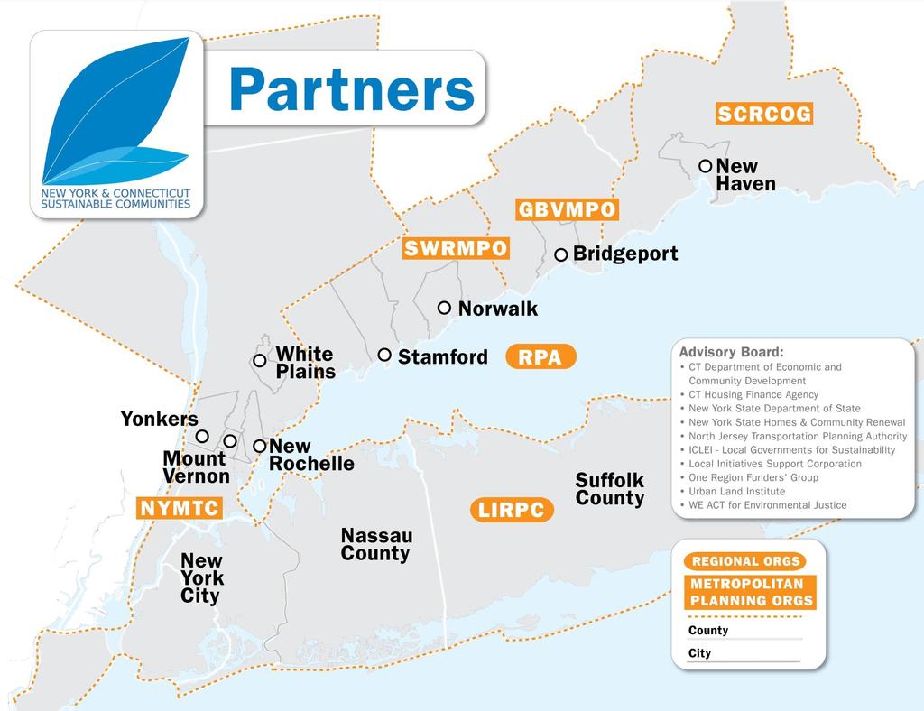
1 NEW YORK AND CONNECTICUT SUSTAINABLE COMMUNITIES Fair Housing & Equity Assessment & Regional Planning Enhancement November 19, 2013 White Plains Public Library


2 Federal grant to improve regional planning to support sustainable communities The Partnership for Sustainable Communities works to coordinate federal housing, transportation, water, and other infrastructure investments to make neighborhoods more prosperous, allow people to live closer to jobs, save households time and money, and reduce pollution.
3 Promote equitable, affordable housing Value communities and neighborhoods. Enhance economic competitiveness LIVABILITY PRINCIPLES Coordinate policies and leverage investment Support existing communities Provide more transportation choices
4
5 What the Consortium can and cannot do The NY-CT Consortium produces plans and recommendations for the region and specific locations based on a work program in an agreement between the consortium partners. Implementation of any plans or recommendations must go through the normal approval processes of the towns, villages, counties and states where proposals are located.

6 Growing the economy, expanding choice Build mixed-income housing and jobs within walking distance of transit
7 Placespecific projects

8 Repurposing the I-287 Corridor 8


9 SOUTHERN WESTCHESTER EAST-WEST CORRIDOR ISSUES SCAN 9

10 NEW ROCHELLE TOD SMART GROWTH STUDY 10


11 Growing the economy, expanding choice Bring opportunity to all communities and all communities to opportunity Number of affordable, energy -efficient homes built in our good school districts Number of good, accessible jobs in our urban areas Access to grocery stores, fresh foods, health care and other needs


12 GROWING THE ECONOMY, EXPANDING CHOICE DEVELOP CLIMATE RESILIENT BUILDINGS AND INFRASTRUCTURE

13 Growing the economy, expanding choice Coordinate federal, state, regional, and local regulatory reforms Identify specific gaps in existing regional plans Analyze regulatory and program impediments to on-the-ground projects Recommend reforms Adopt an Execution Plan for Regional Sustainable Development


14 16 regional and place-specific projects REGIONAL PLANNING ENHANCEMENT AND INTEGRATION SPECIFIC PLACE-BASED AND AREA-WIDE PROJECTS Transportation Plans Northern Sector Place- Based Sustainability Projects New Haven, Bridgeport, Stamford, Norwalk, New Rochelle Bronx Stations I-287 and Cross County Parkway corridors Sustainability Plans Regional Plan for Sustainable Development Economic Development Plans East New York Nassau Centers Suffolk Transfer-of- Development Rights Long Island Housing Strategy Master Plans Housing Plans Areawide Policy Projects Regional Planning Enhancement Regional Fair Housing & Equity Assessment NYC Climate Resilience
15 Addressing Equity & 0pportunity: The Regional Fair Housing and Equity Assessment (FHEA)
16 What is the Fair Housing and Equity Assessment (FHEA)? An analysis of the segregation patterns and disparities in the region An inclusive deliberation process to identify the factors contributing to these patterns and strategies to overcome them A bridge to decision-making and investments
17 Outcomes FHEA will be incorporated in the NY-CT consortium s Regional Execution Plan for Sustainable Development to: Include strategies to address fair housing barriers and other issues identified in the FHEA, including actions for consortiumled projects Improve regional planning to support access to opportunity Information in FHEA can also be used to: Assist states and municipalities in developing their housing analyses and plans Assist other fair housing and community development efforts
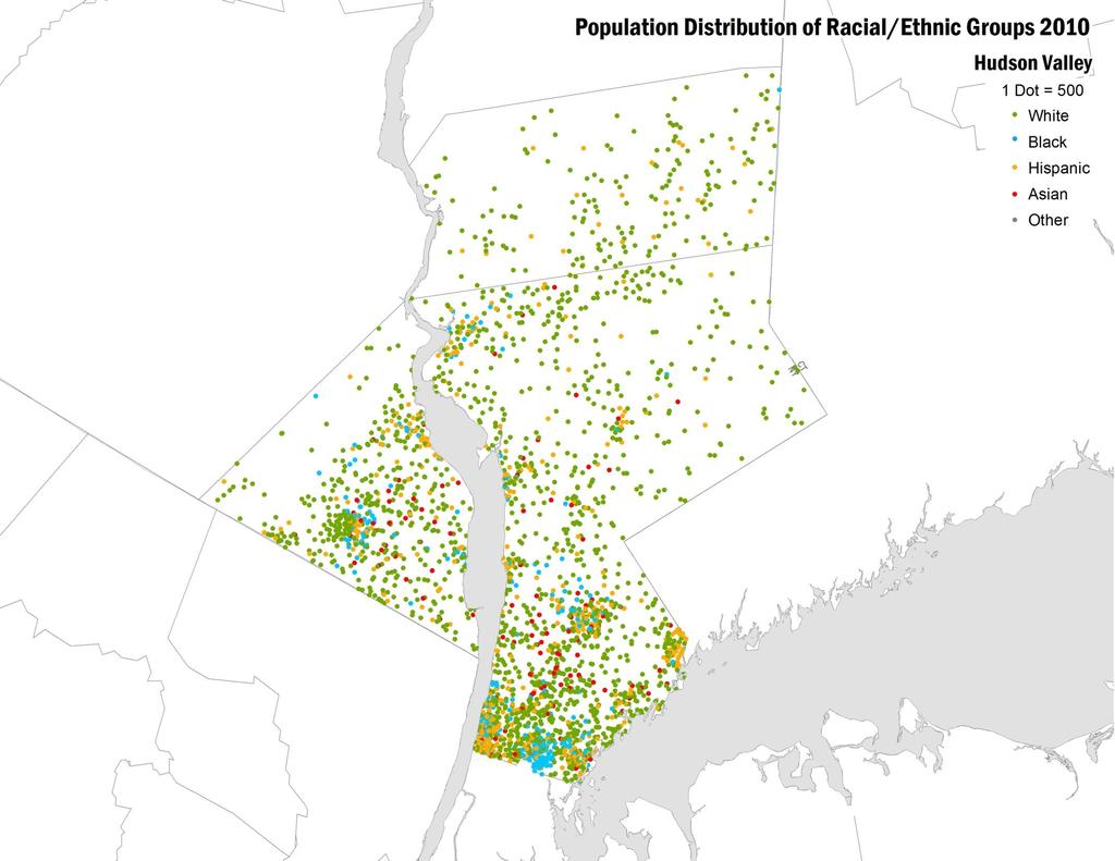
18 Suburbs are becoming increasingly diverse, but African-Americans and Hispanics remain concentrated in cities
19
20
21
22


23 African-Americans, Hispanics and Asians represent nearly half the region s population
24 but we remain one of the most segregated regions in the nation Dissimilarity index measures how evenly two groups are distributed across an area On a scale of 0 (completely integrated) to 1 (completely segregated), the region scores.78 for black-white segregation, nearly twice the average for all metropolitan areas Source: Brown University,
 Intended to identify areas of most intense need Does not capture all areas of poverty or racial")
25 Racially and Ethnically Concentrated Areas of Poverty Mostly in Cities Racially/Ethnically- Concentrated Areas of Poverty (R/ECAP) Majority non-white population (>50%) high poverty rate (percent of population in poverty>=40% or 3X area average) Intended to identify areas of most intense need Does not capture all areas of poverty or racial segregation
26 Most African-Americans, Hispanics and Asians, as well as ¾ of all races living in poverty, live outside of R/ECAPs 20% of Hispanics 16% of African- Americans 4% of Asians 1% of Whites 24% of those in poverty 29% of federally subsidized housing units


27 A few more R/ECAPs are identified using average Hudson Valley poverty rates 27

28 44% of lower Hudson Valley lives in census tracts that are over 75% white 28
29 compared to 11% of federally-subsidized housing in primarily white census tracts 29


30 How do planning decisions impact poverty and segregation? Share of Population Below Poverty Level R/ECAP Open Space Poverty Rate >= 18% (bottom 30%) % (middle 40%) <= 5.1% (top 30%) 30
31 How can housing and land use improve access to good schools and services? School proficiency by 8 th grade test scores Average Test Score 8th Grade Math & Reading, 2012 Bottom 30% Middle 40% Top 30% No 8th Grade (Scores) Open Space 31
32 IN PROCESS: Evaluating causes and solutions with help of an Advisory Committee HUD s examples of causes of segregation Siting of affordable housing Zoning /land use barriers Local residency preferences Lack of HCV landlords Land/infrastructure availability Source of income discrimination Community opposition/nimbyism Realtor steering by race HUD s examples of issues to explore in RCAPs Housing quality Opportunities to stabilize existing housing Job access (especially lowwage/entry level) Access to effective transportation Bank/loan presence or absence Availability of infrastructure, such as sidewalks, street lights School quality
33 IN PROCESS: Recommendations for improving meaningful engagement in planning processes, such as Including more community leaders and organizations in planning meetings and outreach Using clear, non-technical language to describe problems and proposals Providing materials in advance of meetings Conducting more than one meeting on topics so individuals have an opportunity to think and confer about the issues and come back with responses and recommendations Translating materials into languages other than English and providing interpreters at the meeting Explicitly asking for concrete solutions, and not just problems Providing timely feedback on how ideas are considered and used
34 Questions What prevents you or others in your community from obtaining the type of home that you need, such as: not enough homes that you can afford being denied an apartment, house or mortgage because of race or color, where you come from, your family status, disability or other reasons being made to feel unwelcome in a neighborhood you want to live in What problems should FHEA prioritize, such as: where affordable housing gets built transportation access to jobs funding for sewers and other infrastructure services to investigate and file complaints about discrimination zoning that doesn t allow rental or multi-family homes community opposition to new housing or residents What are the most important actions that should be taken?


35 Planning Enhancements for Sustainable Development Preliminary Findings & Potential Approaches November/December 2013
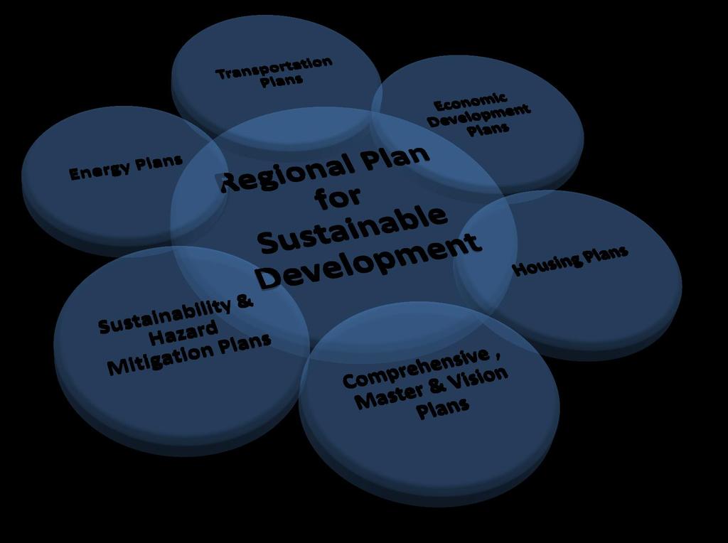
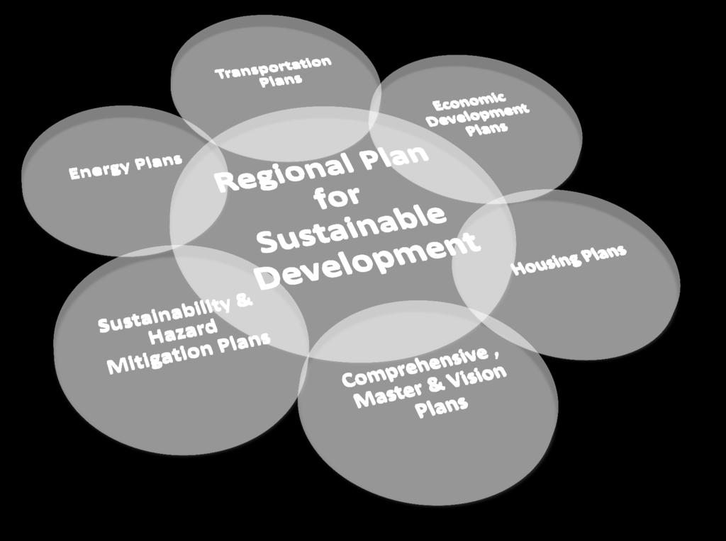
36 What is sustainability planning?
 or MPO Statewide Comprehensive plan (NY) Master plan or vision")
 HUD consolidated plan Regional plan of conservation and")
 Strategic economic development plan (NY) HUD consolidated plan Energy")
 Multi-hazard mitigation plan Multi-hazard mitigation plan Sustainability plan")
37 Assessment of current planning practices Local municipal County (NY) or RPO (CT) Multicounty (NY) or MPO Statewide Comprehensive plan (NY) Master plan or vision plan (NY) Transportation plan Transportation plan Plan of conservation and development (CT) HUD consolidated plan Regional plan of conservation and development (CT) HUD consolidated plan Coordinated public transit-human services plan (NY) Strategic economic development plan (NY) HUD consolidated plan Energy plan (NY) and energy strategy (CT) Coordinated public transit-human services plan (CT) Multi-hazard mitigation plan Multi-hazard mitigation plan Sustainability plan (NY) Multi-hazard mitigation plan

38 What broad themes emerged from the Consortium members plans?

39 What primary planning gaps emerged from the analysis of relevant plans? Coordinating Regional and Local Transportation Planning Prioritizing Areas of Growth and Conservation Linking Transportation, Housing, and Economic Development with Transit-Oriented Development Linking Job Access and Economic Opportunity Incorporating Hazard Mitigation and Resiliency Regional Strategies for Energy Efficiency Preserving Open Space and Reducing Pollutants

40 How can regional, state and federal programs better support local sustainable development?

41 What specific barriers to implementation emerged from the place-based projects?
42 Potential Approaches for Filling the Planning Gaps: Cross-Acceptance A cross-acceptance process is one potential mechanism for better linking planning at multiple levels. Cross-acceptance is a process by which municipal, regional, and statewide plans could be compared and linked in an effort to achieve greater consistency and compatibility. A cross-acceptance process could be established as a formal legislated process or a more informal clearinghouse-type arrangement.
43 Potential Approaches for Filling the Planning Gaps: Standards for Common Components Short of a full cross-acceptance process, standards could be established to require common components of plans at multiple levels. As an example, coordinated job access components should be included in HUD consolidated plans at all levels, as well as MPO regional transportation plans. Additionally, common economic development components in local, regional and statewide plans would also enhance planning for both job access and for community economic development.
44 Potential Approaches for Filling the Planning Gaps: Partnerships for Specific Locations A more spatially-specific approach to better integrating planning at multiple levels could involve: Partnerships, including local municipalities, convened by counties in New York and regional planning organizations in Connecticut Organized around critical transportation corridors and projects. Statewide and MPO transportation plans can be used to target. Federal and/or state planning resources can be made available as an added incentive for local participation in these targeted planning initiatives.
 comprehensive plans (and plans of conservation and development) HUD-required consolidated plans at these levels Metropolitan planning organization regional")
45 Potential Approaches for Supporting Transit-Oriented Development Mixed income, energy efficient TOD is most achievable when potential TOD projects are incorporated in: Local municipal and county (or regional planning organization) comprehensive plans (and plans of conservation and development) HUD-required consolidated plans at these levels Metropolitan planning organization regional transportation plans and Regional Economic Development Councils strategic plans (in New York State) Statewide consolidated plans, transportation plans and economic development plans.


46 #1: Uncoordinated Other Actions federal and to state Support regulations pose impediments to mixed-use, mixed-income TOD Allow more flexibility in housing and transportation funding to support mixeduse development Reduce number of multiple permits and applications Ease parking regulations that make development more expensive Provide federal tax credits for energy conservation or economic resiliency districts Expand use of overlay zones and generic environmental impact statements Sustainable TOD WHAT REGULATORY CHANGES WILL HAVE THE MOST BENEFICIAL IMPACT? With impetus from Partnership for Sustainable Communities, CNU and others, FHA financing rules are being reformed to allow more mixed-use development 46

47 A recap of potential approaches... Cross-accepted plans Transportation Common plan sections Comprehensive, master and vision Conservation and development Transportation & Coordinated Public Transit-Human Services Spatially-specific approaches HUD consolidated Hazard mitigation Transportation, energy, economic development and sustainability Critical transportation corridor/project partnerships Overlay districts Generic environmental impact statements
48 Discussing the potential approaches... Of the planning needs identified, which are most important to address? Is anything missing? How can community members meaningfully participate in local and regional planning processes? What type of meeting and outreach would encourage participation? What kind of information would be useful? What would build trust that ideas are heard and influence outcomes? Do the cross-acceptance or other proposals make sense? What other information is needed to evaluate them? What other actions are needed to create more sustainable and equitable development?


49 QUESTIONS OR COMMENTS Contact Brian Dennis, with questions or comments on the presentation, or visit for general information on the initiative.
NEW YORK AND CONNECTICUT SUSTAINABLE COMMUNITIES. Fair Housing & Equity Assessment & Regional Planning Enhancement
 NEW YORK AND CONNECTICUT SUSTAINABLE COMMUNITIES Fair Housing & Equity Assessment & Regional Planning Enhancement November 18, 2013 Fordham University Bronx, NY Federal grant to improve regional planning
Initial Findings from Regional Initiatives Planning Enhancement Fair Housing & Equity Assessment
 NEW YORK AND CONNECTICUT SUSTAINABLE COMMUNITIES Initial Findings from Regional Initiatives Planning Enhancement Fair Housing & Equity Assessment July 30, 2013 White Plains Library Federal grant to improve
Environmental Analysis, Chapter 4 Consequences, and Mitigation
 Environmental Analysis, Chapter 4 4.17 Environmental Justice This section summarizes the potential impacts described in Chapter 3, Transportation Impacts and Mitigation, and other sections of Chapter 4,
Proposed Scope of Work Village of Farmingdale Downtown Farmingdale BOA Step 2 BOA Nomination Study / Draft Generic Environmental Impact Statement
 Proposed Scope of Work Village of Farmingdale Downtown Farmingdale BOA Step 2 BOA Nomination Study / Draft Generic Environmental Impact Statement The scope of work that follows incorporates and covers
Mapping and Health Equity Advocacy
 Mapping and Health Equity Advocacy Sarah Treuhaft PolicyLink November 7, 2008 About us PolicyLink National research and action institute that advances policies to achieve economic and social equity Center
Regional Growth Strategy Regional Staff Committee
 Regional Growth Strategy Regional Staff Committee June 21, 2018 1 Overview Summary of June Growth Management Policy Board Regional Growth Strategy Objectives Regional Geographies Regional Growth Strategy
Together towards a Sustainable Urban Agenda
 Together towards a Sustainable Urban Agenda The City We (Youth) Want Preliminary findings from youth consultations Areas Issue Papers Policy Units 1.Social Cohesion and Equity - Livable Cities 2.Urban
City of Manitou Springs
 March 2018 City of Manitou Springs Implementing Land Use tools to reduce and mitigate natural hazard risk Context & History Past Present Historic homes Older infrastructure Hillside development Creekside
Section 2. Indiana Geographic Information Council: Strategic Plan
 Section 2. Indiana Geographic Information Council: Strategic Plan Introduction A geographic information system (GIS) is an automated tool that allows the collection, modification, storage, analysis, and
ADDRESSING TITLE VI AND ENVIRONMENTAL JUSTICE IN LONG-RANGE TRANSPORTATION PLANS
 ADDRESSING TITLE VI AND ENVIRONMENTAL JUSTICE IN LONG-RANGE TRANSPORTATION PLANS Activities from the National Capital Region Transportation Planning Board Sergio Ritacco Transportation Planner 2017 Association
New Partners for Smart Growth: Building Safe, Healthy, and Livable Communities Mayor Jay Williams, Youngstown OH
 New Partners for Smart Growth: Building Safe, Healthy, and Livable Communities Mayor Jay Williams, Youngstown OH The City of Youngstown Youngstown State University Urban Strategies Inc. Youngstown needed
The CRP stresses a number of factors that point to both our changing demographics and our future opportunities with recommendations for:
 Plan Overview The CRP represents the first broad planning initiative covering Lake, Porter and LaPorte counties. Unlike previous plans released by NIRPC, which focused primarily on transportation, the
A GIS TOUR OF DES MOINES PRESENTED BY ANNA WHIPPLE, GIS MANAGER APRIL 20, 2015
 A GIS TOUR OF DES MOINES PRESENTED BY ANNA WHIPPLE, GIS MANAGER APRIL 20, 2015 Welcome to Des Moines! Capital of Iowa Among 100 largest metropolitan areas Insurance, biotech, healthcare, and entertainment
The Governance of Land Use
 The planning system The Governance of Land Use United Kingdom Levels of government and their responsibilities The United Kingdom is a unitary state with three devolved governments in Northern Ireland,
International Guidelines on Access to Basic Services for All
 International Guidelines on Access to Basic Services for All Presentation and initials lessons from implementation Accessibility to services in regions and cities : measures and policies, OECD 18 June
PLANNING (PLAN) Planning (PLAN) 1
 Planning (PLAN) 1") Planning (PLAN) 1 PLANNING (PLAN) PLAN 500. Economics for Public Affairs Description: An introduction to basic economic concepts and their application to public affairs and urban planning. Note: Cross-listed
Planning (PLAN) 1 PLANNING (PLAN) PLAN 500. Economics for Public Affairs Description: An introduction to basic economic concepts and their application to public affairs and urban planning. Note: Cross-listed
CLAREMONT MASTER PLAN 2017: LAND USE COMMUNITY INPUT
 Planning and Development Department 14 North Street Claremont, New Hampshire 03743 Ph: (603) 542-7008 Fax: (603) 542-7033 Email: cityplanner@claremontnh.com www.claremontnh.com CLAREMONT MASTER PLAN 2017:
Concept note. High-Level Seminar: Accelerating Sustainable Energy for All in Landlocked Developing Countries through Innovative Partnerships
 Concept note High-Level Seminar: Accelerating Sustainable Energy for All in Landlocked Developing Countries through Innovative Partnerships Date: 24 and 25 October 2016 Venue: Conference Room C3, Vienna
Recovery Renewal Rebuilding
 Recovery Renewal Rebuilding Federal Reserve Foreclosure Series Washington, D.C. October 20, 2008 Mayor Jay Williams, Youngstown OH The City of Youngstown Youngstown State University Urban Strategies Inc.
MODULE 1 INTRODUCING THE TOWNSHIP RENEWAL CHALLENGE
 MODULE 1 INTRODUCING THE TOWNSHIP RENEWAL CHALLENGE FOCUS OF THE MODULE Township renewal challenges and developmental outcomes covered in this module: Historical origins of townships and the inherited
Neighborhood Locations and Amenities
 University of Maryland School of Architecture, Planning and Preservation Fall, 2014 Neighborhood Locations and Amenities Authors: Cole Greene Jacob Johnson Maha Tariq Under the Supervision of: Dr. Chao
Introduction and Project Overview
 Greater New Orleans Regional Land Use Modeling GIS Techniques in a P olitical C ontext Louisiana Remote Sensing and GIS Workshop Wednesday, April 24, 2013 Working Towards a Shared Regional Vision Introduction
Shaping Your Neighbourhood
 Shaping Your Neighbourhood Building a Core Sustainable Neighbourhood Action Plan Nov. 25 & 26, 2006 Welcome! Peter Russell Planner, Holland Barrs Planning Group Inc. Role in this project: Work with the
Sustainable Suburbs: Restructuring Suburban Development
 Sustainable Suburbs: Restructuring Suburban Development Stephen B. Friedman, AICP, CRE ULI Forum, October 8, 2009 The Vocabulary of Growth CAVE NIMBY BANANA NOTE NOPE NIMEY Triple Bottom Line Profitability
Why care about metropolitan and regional perspectives?
 Metropolitan challenges and solutions Why care about metropolitan and regional perspectives? Irma Karjalainen, Director, Helsinki Region Environmental Services Authority HSY, LUMAT Conference, 25 September
Regional Growth Strategy Work Session Growth Management Policy Board
 Regional Growth Strategy Work Session Growth Management Policy Board September 6, 2018 1 Overview Recap June GMPB work session Objectives and outcomes Regional geographies Growth scenarios Breakout Discussion:
Council Workshop on Neighbourhoods Thursday, October 4 th, :00 to 4:00 p.m. Burlington Performing Arts Centre
 Council Workshop on Neighbourhoods Thursday, October 4 th, 2012 1:00 to 4:00 p.m. Burlington Performing Arts Centre Agenda Introductions Warm-Up Exercise Presentation Exercise Neighbourhood Planning Break
APPENDIX C-3 Equitable Target Areas (ETA) Technical Analysis Methodology
 Technical Analysis Methodology") APPENDIX C-3 Equitable Target Areas (ETA) Technical Analysis Methodology Contents Introduction... 1 ETA Index Methodology... 1 ETA Index Development... 1 Other EJ Measures... 4 The Limited English Proficiency
APPENDIX C-3 Equitable Target Areas (ETA) Technical Analysis Methodology Contents Introduction... 1 ETA Index Methodology... 1 ETA Index Development... 1 Other EJ Measures... 4 The Limited English Proficiency
Economic Activity Economic A ctivity
 5 Economic Economic Activity Activity ECONOMIC ACTIVITY 5.1 EMPLOYMENT... 5-7 5.1.1 OBJECTIVE... 5-7 5.1.2 POLICIES... 5-7 5.2 PROTECTING THE AREA OF EMPLOYMENT... 5-9 5.2.1 OBJECTIVE... 5-9 5.2.2 POLICIES...
GOVERNMENT MAPPING WORKSHOP RECOVER Edmonton s Urban Wellness Plan Mapping Workshop December 4, 2017
 GOVERNMENT MAPPING WORKSHOP 12.4.17 RECOVER Edmonton s Urban Wellness Plan Mapping Workshop December 4, 2017 In July of 2017, City Council directed administration to develop RECOVER, Edmonton s Urban Wellness
DBSA Knowledge Week Yusuf Patel South African Planning Institute
 Sustainable Human Settlements - Institutional Issues DBSA Knowledge Week Yusuf Patel South African Planning Institute 20 October 2010 Spatial Planning for Long Term Apartheid engineered spatial economy
Study Overview. the nassau hub study. The Nassau Hub
 Livable Communities through Sustainable Transportation the nassau hub study AlternativeS analysis / environmental impact statement The Nassau Hub Study Overview Nassau County has initiated the preparation
Subject: Note on spatial issues in Urban South Africa From: Alain Bertaud Date: Oct 7, A. Spatial issues
 Page 1 of 6 Subject: Note on spatial issues in Urban South Africa From: Alain Bertaud Date: Oct 7, 2009 A. Spatial issues 1. Spatial issues and the South African economy Spatial concentration of economic
Frequently Asked Questions
 What is the Regional Transit Engagement Series? As one of the fastest growing regions in the country, there is recognition that long-term transit planning efforts should be accelerated if we are to remain
Integrated Infrastructure Planning & Spatial Mapping
 Integrated Infrastructure Planning & Spatial Mapping Presenter: Heidi Dixon, Principal Social Planner, DTPLI 23 May 2014 PART 1 PLAN MELBOURNE : Metropolitan Planning Strategy PART 2 Case Study: DTPLI
CERTIFIED RESOLUTION. introduction: and dated May 29, 2017, as attached, as appropriate
 15322 Buena Vista Avenue, White Rock BC, Canada V4B 1Y6 www.whiterockcity.ca City of White Rock P: 604.541.22121 F: 604.541.9348 /2tC% City Clerk s Office IT E ROC K June 13,2017 Stephanie Lam, Deputy
REPUBLIC OF ZAMBIA STATEMENT THE HONOURABLE LUCKY MULUSA, M.P., MINISTER OF NATIONAL DEVELOPMENT PLANNING,
 REPUBLIC OF ZAMBIA Permanent Mi$sion of Zambia to the United Nations, 237 East 52nd Street, New York, NY 10022 Tex: (212) 888-5770 Fax: (212) 888-5213 E-mail: zambia@un.int Please check against delivery
ONE REGION: PLANNING FOR A STRONG AND JUST METROPOLIS. NYLON # 14: Regional Planning. October 31, 2018
 DRAFT ONE REGION: PLANNING FOR A STRONG AND JUST METROPOLIS NYLON # 14: Regional Planning October 31, 2018 Carolyn Grossman Meagher, Director, Regional Planning Division the New Yorker March 1976. A New
Population Profiles
 U N D E R S T A N D I N G A N D E X P L O R I N G D E M O G R A P H I C C H A N G E MAPPING AMERICA S FUTURES, BRIEF 6 2000 2010 Population Profiles Atlanta, Las Vegas, Washington, DC, and Youngstown Allison
November 29, World Urban Forum 6. Prosperity of Cities: Balancing Ecology, Economy and Equity. Concept Note
 November 29, 2010 World Urban Forum 6 Prosperity of Cities: Balancing Ecology, Economy and Equity Concept Note 1 CONTENT Thematic Continuity Conceptualizing the Theme The 6 Domains of Prosperity The WUF
CORPORATION OF THE CITY OF COURTENAY COUNCIL MEETING AGENDA
 CORPORATION OF THE CITY OF COURTENAY COUNCIL MEETING AGENDA DATE: Monday, January 14, 2013 PLACE: City Hall Council Chambers TIME: 4:00 p.m. 1.00 ADOPTION OF MINUTES 1. Adopt January 7, 2013 Regular Council
CHAPTER 4 HIGH LEVEL SPATIAL DEVELOPMENT FRAMEWORK (SDF) Page 95
 Page 95") CHAPTER 4 HIGH LEVEL SPATIAL DEVELOPMENT FRAMEWORK (SDF) Page 95 CHAPTER 4 HIGH LEVEL SPATIAL DEVELOPMENT FRAMEWORK 4.1 INTRODUCTION This chapter provides a high level overview of George Municipality s
CHAPTER 4 HIGH LEVEL SPATIAL DEVELOPMENT FRAMEWORK (SDF) Page 95 CHAPTER 4 HIGH LEVEL SPATIAL DEVELOPMENT FRAMEWORK 4.1 INTRODUCTION This chapter provides a high level overview of George Municipality s
King City URA 6D Concept Plan
 King City URA 6D Concept Plan King City s Evolution Among the fastest growing cities 2000 Census 1,949 2010 Census 3,111 60% increase 2016 Census estimate 3,817 23% increase Average annual rate 4.3% Surpassing
National Spatial Development Perspective (NSDP) Policy Coordination and Advisory Service
 Policy Coordination and Advisory Service") National Spatial Development Perspective (NSDP) Policy Coordination and Advisory Service 1 BACKGROUND The advances made in the First Decade by far supersede the weaknesses. Yet, if all indicators were
National Spatial Development Perspective (NSDP) Policy Coordination and Advisory Service 1 BACKGROUND The advances made in the First Decade by far supersede the weaknesses. Yet, if all indicators were
GIS in Community & Regional Planning
 GIS in Community & Regional Planning The The role role of of GIS GIS in in Re-writing the the Zoning Bylaw for for the the City City of of Vernon LandInfo Technologies Presentation Overview The GIS Initiative
Jobs-Housing Fit: Linking Housing Affordability and Local Wages
 Jobs-Housing Fit: Linking Housing Affordability and Local Wages Alex Karner, PhD Assistant Professor School of City and Regional Planning Georgia Institute of Technology Chris Benner, PhD Dorothy E. Everett
Local Area Key Issues Paper No. 13: Southern Hinterland townships growth opportunities
 Draft Sunshine Coast Planning Scheme Review of Submissions Local Area Key Issues Paper No. 13: Southern Hinterland townships growth opportunities Key Issue: Growth opportunities for Southern Hinterland
Measuring Disaster Risk for Urban areas in Asia-Pacific
 Measuring Disaster Risk for Urban areas in Asia-Pacific Acknowledgement: Trevor Clifford, Intl Consultant 1 SDG 11 Make cities and human settlements inclusive, safe, resilient and sustainable 11.1: By
Streamlined Annual PHA Plan (Small PHAs)
") Streamlined Annual PHA Plan (Small PHAs) U.S. Department of Housing and Urban Development Office of Public and Indian Housing OMB No. 2577-0226 Expires: 02/29/2016 Purpose. The 5-Year and Annual PHA Plans
Streamlined Annual PHA Plan (Small PHAs) U.S. Department of Housing and Urban Development Office of Public and Indian Housing OMB No. 2577-0226 Expires: 02/29/2016 Purpose. The 5-Year and Annual PHA Plans
KUNMING FORUM ON UNITED NATIONS GLOBAL GEOSPATIAL INFORMATION MANAGEMENT CITIES OF THE FUTURE: SMART, RESILIENT
 KUNMING FORUM ON UNITED NATIONS GLOBAL GEOSPATIAL INFORMATION MANAGEMENT CITIES OF THE FUTURE: SMART, RESILIENT and SUSTAINABLE Yunnan Zhenzhuang Guest House, Kunming, China 10 12 May 2017 BACKGROUND CONCEPT
Leveraging Urban Mobility Strategies to Improve Accessibility and Productivity of Cities
 Leveraging Urban Mobility Strategies to Improve Accessibility and Productivity of Cities Aiga Stokenberga World Bank GPSC African Regional Workshop May 15, 2018 Roadmap 1. Africa s urbanization and its
National planning report for Denmark
 National planning report for Denmark from the Minister for Environment and Energy Local identity and new challenges Summary 2000 1 CONTENTS 4 PREFACE: REGIONAL DEVELOPMENT AND SPATIAL PLANNING 6 1. BALANCED
UN-GGIM: Strengthening Geospatial Capability
 Fifth Plenary Meeting of UN-GGIM: Europe Brussels, 6-7 June 2018 UN-GGIM: Strengthening Geospatial Capability Walking the talk to leave no one behind Greg Scott, UN-GGIM Secretariat Environmental Statistics
CRP 608 Winter 10 Class presentation February 04, Senior Research Associate Kirwan Institute for the Study of Race and Ethnicity
 CRP 608 Winter 10 Class presentation February 04, 2010 SAMIR GAMBHIR SAMIR GAMBHIR Senior Research Associate Kirwan Institute for the Study of Race and Ethnicity Background Kirwan Institute Our work Using
The National Spatial Strategy
 Purpose of this Consultation Paper This paper seeks the views of a wide range of bodies, interests and members of the public on the issues which the National Spatial Strategy should address. These views
Red Hook Recovery Project. Hurricane Sandy An Urban Disaster
 Red Hook Recovery Project Hurricane Sandy An Urban Disaster Overview Impact of Changing weather Urban Preparedness Overview of preparedness efforts Complexities of urban planning (Ex. NYC) Understanding
Planning for Economic and Job Growth
 Planning for Economic and Job Growth Mayors Innovation Project Winter 2012 Meeting January 21, 2012 Mary Kay Leonard Initiative for a Competitive Inner City AGENDA The Evolving Model for Urban Economic
State initiative following up the 2006 national planning report
 18 ness districts and public institutions, should be integrated with the opportunities for public transport services. State initiative following up the 2006 national planning report The Ministry of the
Committee Meeting November 6, 2018
 Committee Meeting November 6, 2018 Agenda Where we are in the process Land Use Plan Transportation Element Housing & Neighborhoods Elements Next Steps Schedule November 6: Plan Elements December: Plan
The econ Planning Suite: CPD Maps and the Con Plan in IDIS for Consortia Grantees Session 1
 The econ Planning Suite: CPD Maps and the Con Plan in IDIS for Consortia Grantees Session 1 1 Training Objectives Use CPD Maps to analyze, assess, and compare levels of need in your community Use IDIS
NEW YORK DEPARTMENT OF SANITATION. Spatial Analysis of Complaints
 NEW YORK DEPARTMENT OF SANITATION Spatial Analysis of Complaints Spatial Information Design Lab Columbia University Graduate School of Architecture, Planning and Preservation November 2007 Title New York
Urban Climate Resilience
 Urban Climate Resilience in Southeast Asia Partnership Project Introduction Planning for climate change is a daunting challenge for governments in the Mekong Region. Limited capacity at the municipal level,
United Growth s Revitalizing Neighborhoods Indicator Project
 United Growth s Revitalizing Neighborhoods Indicator Project Group Members: Prachi Kulkarni Mark O Neall Kent Harding Megan O Brien Paris Howard Blake Hamilton Kerry Hoo http://www.city-data.com/picfilesc/picc32475.php
Urbanization and Sustainable Development of Cities: A Ready Engine to Promote Economic Growth and Cooperation
 Urbanization and Sustainable Development of Cities: A Ready Engine to Promote Economic Growth and Cooperation Wan Portia Hamzah Institute of Strategic and International Studies (ISIS) Malaysia 10 September
Date: June 19, 2013 Meeting Date: July 5, Consideration of the City of Vancouver s Regional Context Statement
 Section E 1.5 To: From: Regional Planning and Agriculture Committee Lee-Ann Garnett, Senior Regional Planner Planning, Policy and Environment Department Date: June 19, 2013 Meeting Date: July 5, 2013 Subject:
East Bay BRT. Planning for Bus Rapid Transit
 East Bay BRT Planning for Bus Rapid Transit Regional Vision Draper Prison The Bottleneck is a State-Level issue, Salt Lake County 2050 Population: 1.5M Draper Prison hopefully with some State-Level funding!
Date: March 31, 2014 PATE; fyril 2.3,2 >H
 aj BRAMPTON fifs Rower City XH-l-f r.t "»* City Council The Corporation of the City of Brampton SRAMPTON CITY COUNCIL Date: March 31, 2014 PATE; fyril 2.3,2 >H File: POO GR VisWhtoJed ^t'th-meeh'^a Subject:
D2E GIS Coordination Initiative Functional Transformation Kick-Off Meeting
 D2E GIS Coordination Initiative Functional Transformation Kick-Off Meeting GIS Functional Transformation Kick-Off Meeting May 13, 2008 D2E GIS Coordination Initiative Functional Transformation Kick-Off
MPOs SB 375 LAFCOs SCAG Practices/Experiences And Future Collaborations with LAFCOs
 Connecting LAFCOs and COGs for Mutual Benefits MPOs SB 375 LAFCOs SCAG Practices/Experiences And Future Collaborations with LAFCOs Frank Wen, Manager Research & Analysis Land Use & Environmental Planning
Ministry of Health and Long-Term Care Geographic Information System (GIS) Strategy An Overview of the Strategy Implementation Plan November 2009
 Strategy An Overview of the Strategy Implementation Plan November 2009") Ministry of Health and Long-Term Care Geographic Information System (GIS) Strategy An Overview of the Strategy Implementation Plan November 2009 John Hill, Health Analytics Branch Health System Information
Ministry of Health and Long-Term Care Geographic Information System (GIS) Strategy An Overview of the Strategy Implementation Plan November 2009 John Hill, Health Analytics Branch Health System Information
PPT Slide. Slide 1 of 32. Notes:
 Slide 1 of 32 This presentaion will describe the background of establishing an agricultural district in Westchester County and how GIS was used to map the district. file:///volumes/web/www/ce/conferences/gis%20present/testfarm/sld001.htm[4/6/11
User Guide. Affirmatively Furthering Fair Housing Data and Mapping Tool. U.S. Department of Housing and Urban Development
 User Guide Affirmatively Furthering Fair Housing Data and Mapping Tool U.S. Department of Housing and Urban Development December, 2015 1 Table of Contents 1. Getting Started... 5 1.1 Software Version...
DEPARTMENT OF GEOLOGY AND MINERAL INDUSTRIES WAYS & MEANS SUBCOMMITTEE ON NATURAL RESOURCES MARCH 2, 2017
 DEPARTMENT OF GEOLOGY AND MINERAL INDUSTRIES WAYS & MEANS SUBCOMMITTEE ON NATURAL RESOURCES MARCH 2, 2017 1 ABOUT DOGAMI AGENCY MISSION, VISION & GOALS 2 Lidar image of a stream network along the Umpqua
Alternatives Analysis
 Alternatives Analysis Prepared for: Metropolitan Atlanta Rapid Transit Authority Prepared by: AECOM/Jacobs-JJG Joint Venture Atlanta, GA November 2012 Page Left Intentionally Blank ii TABLE OF CONTENTS
The Spatial Structure of Cities: International Examples of the Interaction of Government, Topography and Markets
 Module 2: Spatial Analysis and Urban Land Planning The Spatial Structure of Cities: International Examples of the Interaction of Government, Topography and Markets Alain Bertaud Urbanist Summary What are
TUESDAYS AT APA PLANNING AND HEALTH. SAGAR SHAH, PhD AMERICAN PLANNING ASSOCIATION SEPTEMBER 2017 DISCUSSING THE ROLE OF FACTORS INFLUENCING HEALTH
 SAGAR SHAH, PhD sshah@planning.org AMERICAN PLANNING ASSOCIATION SEPTEMBER 2017 TUESDAYS AT APA PLANNING AND HEALTH DISCUSSING THE ROLE OF FACTORS INFLUENCING HEALTH Outline of the Presentation PLANNING
Economic and Social Council
 United Nations Economic and Social Council Distr.: General 18 July 2016 Original: English Committee of Experts on Global Geospatial Information Management Sixth session New York, 3-5 August 2016 Item 2
3D - Boulder Valley Comprehensive Plan. Lesli Ellis Comprehensive Planning Manager City of Boulder
 3D - Boulder Valley Comprehensive Plan Lesli Ellis Comprehensive Planning Manager City of Boulder Presentation Boulder s use of 3D GIS and other tools in Comprehensive Planning (e.g., story maps, CityEngine,
The 3V Approach. Transforming the Urban Space through Transit Oriented Development. Gerald Ollivier Transport Cluster Leader World Bank Hub Singapore
 Transforming the Urban Space through Transit Oriented Development The 3V Approach Gerald Ollivier Transport Cluster Leader World Bank Hub Singapore MDTF on Sustainable Urbanization The China-World Bank
Land Use in the context of sustainable, smart and inclusive growth
 Land Use in the context of sustainable, smart and inclusive growth François Salgé Ministry of sustainable development France facilitator EUROGI vice president AFIGéO board member 1 Introduction e-content+
Tourism. April State Planning Policy state interest guideline. Department of Infrastructure, Local Government and Planning
 Department of Infrastructure, Local Government and Planning State Planning Policy state interest guideline Tourism April 2016 Great state. Great opportunity. Preface Using this state interest guideline
RURAL-URBAN PARTNERSHIPS: AN INTEGRATED APPROACH TO ECONOMIC DEVELOPMENT
 RURAL-URBAN PARTNERSHIPS: AN INTEGRATED APPROACH TO ECONOMIC DEVELOPMENT William Tompson Head of the Urban Development Programme OECD Public Governance and Territorial Development Directorate JAHRESTAGUNG
Joint Planning Advisory Council July 19, 2011
 Joint Planning Advisory Council July 19, 2011 Global Cities Program Objectives Helping advance strategic thinking in a variety of critical areas. Facilitating informed decisionmaking on the part of public
HORIZON 2030: Land Use & Transportation November 2005
 PROJECTS Land Use An important component of the Horizon transportation planning process involved reviewing the area s comprehensive land use plans to ensure consistency between them and the longrange transportation
c. What is the most distinctive above ground result of high land costs and intensive land use? i. Describe the vertical geography of a skyscraper?
 AP Human Geography Unit 7b Guided Reading: Urban Patterns and Social Issues Mr. Stepek Key Issue #1: Why Do Services Cluster Downtown? (Rubenstein p 404 410) 1. What is the CBD? What does it contain and
Cultural Data in Planning and Economic Development. Chris Dwyer, RMC Research Sponsor: Rockefeller Foundation
 Cultural Data in Planning and Economic Development Chris Dwyer, RMC Research Sponsor: Rockefeller Foundation A Decade of Attempts to Quantify Arts and Culture Economic impact studies Community indicators
Mapping Communities of Opportunity in New Orleans
 Mapping Communities of Opportunity in New Orleans December 11, 2009 Samir Gambhir Senior Research Associate Kirwan Institute for the study of Race and Ethnicity The Ohio State University Gambhir.2@osu.edu
Urbanization Inside the City 2
 DATES TO REMEMBER COURSE EVALUATION PERIOD OPEN to Dec. 20. Sign in with your Hunter NetID and password Check your Hunter email account for notice from the Dean of Students. TODAY, Mon., Dec 12: Last class
2018/1 The integration of statistical and geospatial information. The Regional Committee of UN-GGIM: Americas:
 The following are the conclusions and recommendations of the Regional Committee of the United Nations on Global Geospatial Information Management for the Americas, during its Fifth Session, Thursday 8
The Governance of Land Use
 The planning system Levels of government and their responsibilities The Governance of Land Use COUNTRY FACT SHEET NORWAY Norway is a unitary state with three levels of government; the national level, 19
STAR COMMUNITY RATING SYSTEM OBJECTIVE EE-4: EQUITABLE SERVICES & ACCESS COMMUNITY LEVEL OUTCOMES FOR KING COUNTY, WA
 STAR COMMUNITY RATING SYSTEM OBJECTIVE EE-4: EQUITABLE SERVICES & ACCESS COMMUNITY LEVEL OUTCOMES FOR KING COUNTY, WA OUTCOME I: EQUITABLE ACCESS AND PROXIMITY Background: This analysis has been developed
We Can Get There From Here: New Perspectives on Transportation Equity
 We Can Get There From Here: New Perspectives on Transportation Equity SEPTEMBER 2016 A White Paper from the National Center for Sustainable Transportation Alex Karner, Georgia Institute of Technology Dana
APPLICATIONS OF EARTHQUAKE HAZARD MAPS TO LAND-USE AND EMERGENCY PLANNING EXAMPLES FROM THE PORTLAND AREA
 APPLICATIONS OF EARTHQUAKE HAZARD MAPS TO LAND-USE AND EMERGENCY PLANNING EXAMPLES FROM THE PORTLAND AREA O. Gerald Uba Metro, Portland, Oregon OVERVIEW The extent to which we understand "below ground"
 BPC Policy No , IIM7fyilK Office of the District Clerk TRANSITION ZONE POLICY")
Problems In Large Cities
 Chapter 11 Problems In Large Cities Create a list of at least 10 problems that exist in large cities. Consider problems that you have read about in this and other chapters and/or experienced yourself.
THE SEVILLE STRATEGY ON BIOSPHERE RESERVES
 THE SEVILLE STRATEGY ON BIOSPHERE RESERVES 1 VISION FOR BIOSPHERE RESERVES IN THE 21 ST CENTURY The international Seville Conference on Biosphere Reserves, organised by UNESCO, adopted a two-pronged approach,
Managing Growth: Integrating Land Use & Transportation Planning
 Managing Growth: Integrating Land Use & Transportation Planning Metro Vancouver Sustainability Community Breakfast Andrew Curran Manager, Strategy June 12, 2013 2 Integrating Land Use & Transportation
WORLD COUNCIL ON CITY DATA
 WORLD COUNCIL ON CITY DATA WCCD ISO 37120 STANDARDIZED CITY DATA TO MEET UN SDG TARGETS UN WORLD DATA FORUM Presented by: James Patava www.dataforcities.org @wccitydata PUBLICATION OF THE FIRST ISO STANDARD
Regional Snapshot Series: Transportation and Transit. Commuting and Places of Work in the Fraser Valley Regional District
 Regional Snapshot Series: Transportation and Transit Commuting and Places of Work in the Fraser Valley Regional District TABLE OF CONTENTS Complete Communities Daily Trips Live/Work Ratio Commuting Local
Carrying Capacity: A New Model For Mature Cities (UC359 )
") Carrying Capacity: A New Model For Mature Cities (UC359 ) Elaine M. Dennehy, AICP City of Arlington, TX Carmen Oprea City of Arlington, TX John Huggins HUD Raha Pouladi UT Arlington (not present) www.arlington-tx.gov/cdp/wp-content/uploads/sites/11/2015/06/carrying_capacityseq.pdf
Carrying Capacity: A New Model For Mature Cities (UC359 ) Elaine M. Dennehy, AICP City of Arlington, TX Carmen Oprea City of Arlington, TX John Huggins HUD Raha Pouladi UT Arlington (not present) www.arlington-tx.gov/cdp/wp-content/uploads/sites/11/2015/06/carrying_capacityseq.pdf