HOME NSGIS PORTS ENESGY DEMO CONTACT. Copyright NorthSouth GIS LLC, All rights reserved.
|
|
|
- Douglas Hawkins
- 5 years ago
- Views:
Transcription

1 The Role of Geospatial Technologies in Port Security


2 Company NorthSouth GIS LLC Founded in 2005 Headquarters in Los Angeles Geospatial Systems Integrator An integral member of the Ports industry Esri s leading partner in ports Esri Gold Partner since 2010 NSGIS


3 What We Do For Ports Support Strategize PEOPLE SOFTWARE DATA Implement Design Needs Assessments Strategic Plans Grants, RFPs, Contracts Implementation Design System Architecture Software Implementation Geodatabase Design Data Conversion Systems Integration COTS Systems Custom Development Training and Outreach Support Staffing

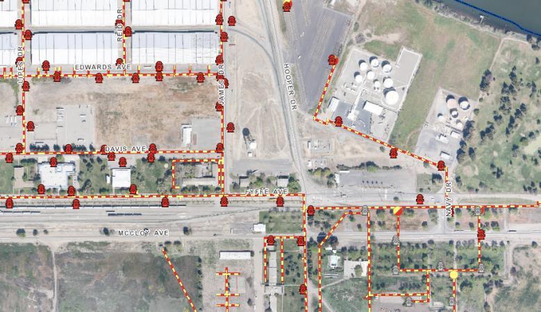
4 Safety and Security Pre-plans Incident analysis Field communications Cameras coverage Crime statistics Data exchange Disaster planning and resiliency Mass notification Event planning mockup


5 Domain Awareness Situational Awareness Live data feeds Security integration Access from field, incident command ICS, escalated data sharing


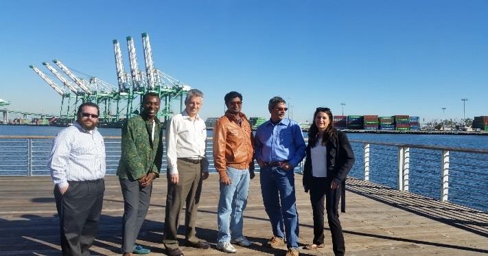
6 Ports Port of Los Angeles Port of Oakland Port of Stockton Port of Tacoma Port Tampa Bay Port of Vancouver Port of Long Beach Port of San Diego Port of Hueneme Port of Houston Port of Charleston
 GIS map")
 Stockton took a phased approach capable of taking advantage of grant, if and when")
7 Port of Stockton Risk exposure: Moderate Security: Large port police Role: Enforcer IT entire enterprise Funding: Grants Tools: Situation awareness system CommandBridge (ARES) GIS map viewer Enesgy (NSGIS) Event planning, document retrieval Enesgy (NSGIS) Mass Notification System HipLink (HipLink) Stockton took a phased approach capable of taking advantage of grant, if and when available

 Event planning, document")

8 Port of Tacoma Risk exposure: Moderate Security: Port police plus security Role: Enforcer IT entire enterprise Funding: Grants and operations Tools: GIS map viewer Enesgy (NSGIS) Event planning, document retrieval Enesgy (NSGIS) Tacoma integrates AIS and video into a police-only GIS viewer, available in office and in cars
 GIS map viewer ArcGIS (Esri) Long Beach has implemented one of the most ambitious initiatives to use geospatial technologies in")
9 Port of Long Beach Risk exposure: Very high Security: Large security force (and PD detail) Role: Enforcer, Enabler, inter-agency aggregator IT entire Security Funding: Grants & operations Tools: Situation awareness system VirtualPort (POLB/Esri) GIS map viewer ArcGIS (Esri) Long Beach has implemented one of the most ambitious initiatives to use geospatial technologies in port security

 GIS map viewer ArcGIS (Esri) Crime analysis CrimeView (TriTech)")

10 Port of San Diego Risk exposure: Very high Security: Large port police, regional collaboration Role: Direct & contract enforcement, local leader IT, mostly for security, facilities, real estate Funding: Operations, grants Tools: Situation awareness system CommandBridge (ARES) GIS map viewer ArcGIS (Esri) Crime analysis CrimeView (TriTech) Incident planning, document retrieval Enesgy (NSGIS) GIS-powered CAD Intergraph (Hexagon) CrimeView Dashboard San Diego makes extensive use of geospatial technologies in its port security and public safety operations


11 Port of Hueneme Risk exposure: Modest Security: Contract security Role: Awareness Engineering Funding: Grants Tools: GIS map viewer Enesgy (NSGIS) Event planning, document retrieval Enesgy (NSGIS) Hueneme focuses on making information available as a means of increasing both safety and security


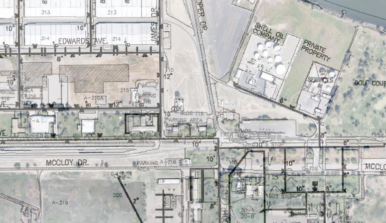
12 Starting Point 1,000s of paper maps and CAD drawings


13 Data Assessment Used GIS to map extents of sources Worked with port to prioritize data for conversion
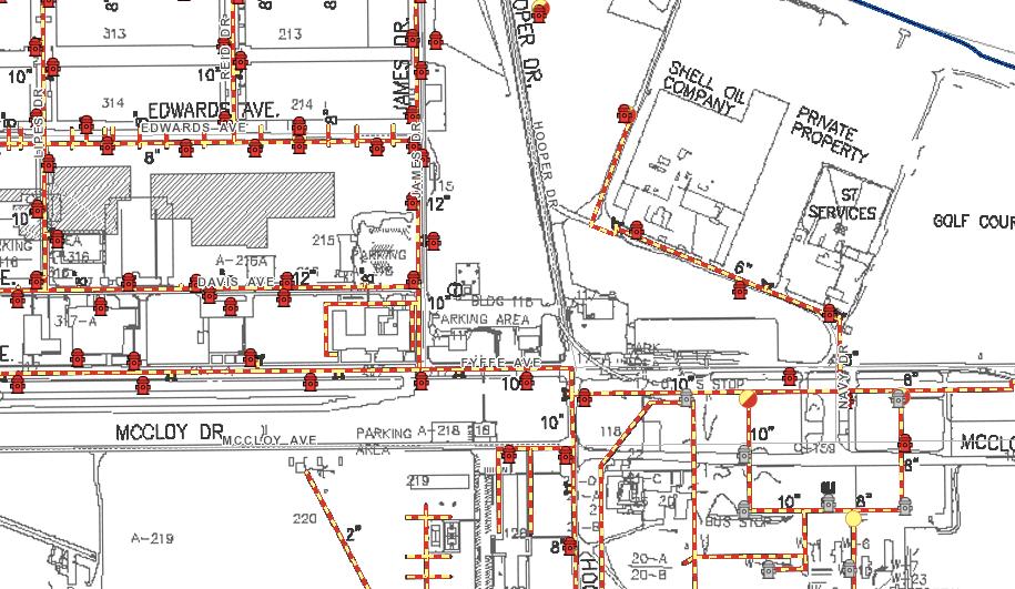

14 Data Conversion

15 Data Verification

16 Applications Data
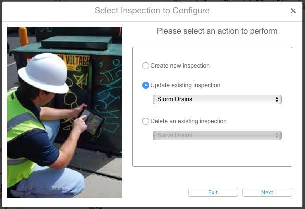
17 Applications Platform-agnostic map viewers AIS vessel data ArcGIS Online tools: Collector, Survey 1-2-3, Story Map Enesgy Events Enesgy Documents Enesgy Map Feedback Enesgy Inspections and Incidents


18 Geospatial Solutions for Ports
19 NorthSouth GIS LLC 244 S. San Pedro Street, Suite 202 Los Angeles, CA Tel: (800) USA Tel: +1 (310) Int l Fax: (213)
HOME NSGIS PORTS ENESGY DEMO CONTACT. Copyright NorthSouth GIS LLC, All rights reserved.
 A Practical Approach to GIS in Ports Company NorthSouth GIS LLC Founded in 2005 Headquarters in Los Angeles Geospatial Systems Integrator An integral member of the Ports industry Esri s leading partner
Mobile Access to Port and Maritime Data
 Mobile Access to Port and Maritime Data Daniel Elroi NorthSouth GIS LLC AAPA Security & IT Conference Arlington, VA, July 21, 2016 NorthSouth GIS LLC The GIS Experts in Ports Company Founded in 2005 Headquarters
GIS for Crime Analysis. Building Better Analysis Capabilities with the ArcGIS Platform
 GIS for Crime Analysis Building Better Analysis Capabilities with the ArcGIS Platform Crime Analysis The Current State One of the foundations of criminological theory is that three things are needed for
Demystifying ArcGIS Online. Karen Lizcano Esri
 Demystifying ArcGIS Online Karen Lizcano Esri An Integrated Web GIS Platform Desktop Web Device Powered by Services Managed via Portal Access from any Device Portal Server Online Content and Services ArcGIS
Crime Analysis. GIS Solutions for Intelligence-Led Policing
 Crime Analysis GIS Solutions for Intelligence-Led Policing Applying GIS Technology to Crime Analysis Know Your Community Analyze Your Crime Use Your Advantage GIS aids crime analysis by Identifying and
June 19 Huntsville, Alabama 1
 June 19 Huntsville, Alabama 1 Real-Time Geospatial Data: The Fusion of PI and ArcGIS Enabling Smarter Facilities Management OSIsoft and Esri Mapping and Location Analytics Platform Supporting Your Use
Web GIS: Architectural Patterns and Practices. Shannon Kalisky Philip Heede
 Web GIS: Architectural Patterns and Practices Shannon Kalisky Philip Heede Web GIS Transformation of the ArcGIS Platform Desktop Apps Server GIS Web Maps Web Scenes Layers Web GIS Transformation of the
ArcGIS for Desktop. ArcGIS for Desktop is the primary authoring tool for the ArcGIS platform.
 ArcGIS for Desktop ArcGIS for Desktop ArcGIS for Desktop is the primary authoring tool for the ArcGIS platform. Beyond showing your data as points on a map, ArcGIS for Desktop gives you the power to manage
USEPA's Comprehensive Geospatial Information Sharing Framework
 USEPA's Comprehensive Geospatial Information Sharing Framework An Overview ESRI Federal User Conference February 22, 2008 Agenda Background What is EPA s Geospatial Information Sharing Framework? Why was
FIRE DEPARMENT SANTA CLARA COUNTY
 DEFINITION FIRE DEPARMENT SANTA CLARA COUNTY GEOGRAPHIC INFORMATION SYSTEM (GIS) ANALYST Under the direction of the Information Technology Officer, the GIS Analyst provides geo-spatial strategic planning,
ArcGIS Pro 3D Workflows. Zena Pelletier
 ArcGIS Pro 3D Workflows Zena Pelletier 3D as a GIS capability Core part of the platform Desktop Web Device Combine 2D and 3D in the same web GIS architecture Reuse dynamic services across clients Securely
ArcGIS. for Server. Understanding our World
 ArcGIS for Server Understanding our World ArcGIS for Server Create, Distribute, and Manage GIS Services You can use ArcGIS for Server to create services from your mapping and geographic information system
GeoHealth Applications Platform ESRI Health GIS Conference 2013
 GeoHealth Applications Platform ESRI Health GIS Conference 2013 Authors Thomas A. Horan, Ph.D. Professor, CISAT Director April Moreno Health GeoInformatics Ph.D. Student Brian N. Hilton, Ph.D. Clinical
Center for Advanced Knowledge Enablement (CAKE)
") Florida International University, Naphtali Rishe, Director, 305.348.2025, rishe@fiu.edu Florida Atlantic University, Borko Furht, 561.297.3180, borko@cse.fau.edu Dubna International University (International
Florida International University, Naphtali Rishe, Director, 305.348.2025, rishe@fiu.edu Florida Atlantic University, Borko Furht, 561.297.3180, borko@cse.fau.edu Dubna International University (International
Information. Information Technology. Geographic. Services (GIS) 119 W Indiana Ave Deland, FL 32720
 119 W Indiana Ave Deland, FL 32720") Information Technology Geographic Information Services (GIS) 119 W Indiana Ave Deland, FL 32720 A GIS consists of 5 primary components: Hardware Software People Data Methods or Business Processes --- Hardware
Information Technology Geographic Information Services (GIS) 119 W Indiana Ave Deland, FL 32720 A GIS consists of 5 primary components: Hardware Software People Data Methods or Business Processes --- Hardware
Maryland Transit Administration (MTA) Bus Accident Mapping and Analysis Application
 Bus Accident Mapping and Analysis Application") Maryland Transit Administration (MTA) Bus Accident Mapping and Analysis Application Ralign Wells, MTA Administrator Bernadette Bridges, MTA Chief Safety Officer Office of Safety, Quality Assurance, and
Maryland Transit Administration (MTA) Bus Accident Mapping and Analysis Application Ralign Wells, MTA Administrator Bernadette Bridges, MTA Chief Safety Officer Office of Safety, Quality Assurance, and
No. of Days. Building 3D cities Using Esri City Engine ,859. Creating & Analyzing Surfaces Using ArcGIS Spatial Analyst 1 7 3,139
 Q3 What s New? Creating and Editing Data with ArcGIS Pro Editing and Maintaining Parcels Using ArcGIS Spatial Analysis Using ArcGIS Pro User Workflows for ArcGIS Online Organizations Q3-2018 ArcGIS Desktop
Introduction to ArcGIS Maps for Office. Greg Ponto Scott Ball
 Introduction to ArcGIS Maps for Office Greg Ponto Scott Ball Agenda What is Maps for Office? Platform overview What are Apps for the Office? ArcGIS Maps for Office features - Visualization - Geoenrichment
Office of Technology Partnerships GIS Collaboration
 Office of Technology Partnerships GIS Collaboration State GIS Update April 21, 2017 Mark Holmes, GISP Outline MGF Upgrade Project Census Programs Imagery Update LiDAR Update Open Discussion 2 MGF Background
The Pace of Change Is Accelerating Creating Many Challenges
 VISION The Pace of Change Is Accelerating Creating Many Challenges Evidence Threatening Our Natural World and Our Future as Humans Social Conflict Mass Migration Ocean Acidification Food Population Urbanization
Optimizing Field Operations
 Optimizing Field Operations with ArcGIS Ismael Chivite Jeff Shaner Chris Lesueur Agenda Notes from the field ArcGIS apps Concepts Demonstrations Q&A Who are we? Ismael Chivite Jeff Shaner Chris LeSueur
BCeMap A Multi Agency Situational Awareness System for the Province of BC
 BCeMap A Multi Agency Situational Awareness System for the Province of BC URISA BC Gurdeep Singh Manager, Business Development & Partnership Portfolio Integrated Land Management Bureau, GeoBC Kristopher
GIS in Response to Oil Spills and other Deleterious Materials
 GIS in Response to Oil Spills and other Deleterious Materials Judd Muskat California Department of Fish and Wildlife Office of Spill Prevention and Response What I Will Cover Office of Spill Prevention
CHAPTER 22 GEOGRAPHIC INFORMATION SYSTEMS
 CHAPTER 22 GEOGRAPHIC INFORMATION SYSTEMS PURPOSE: This chapter establishes the administration and use of to improve the quality and accessibility of Department s spatial information and support graphical
GIS. in the City of Lewiston Maine
 GIS in the City of Lewiston Maine The purpose of this slideshow is to provide an overview of the city GIS and how it is used, maintained and accessed in-house as well as by the public. Please simply hit
PUBLIC SAFETY POWER SHUTOFF POLICIES AND PROCEDURES
 PACIFIC GAS AND ELECTRIC COMPANY PUBLIC SAFETY POWER SHUTOFF POLICIES AND PROCEDURES SEPTEMBER 2018 1 PACIFIC GAS AND ELECTRIC COMPANY PUBLIC SAFETY POWER SHUTOFF POLICIES AND PROCEDURES SEPTEMBER 2018
Maryland Transit Administration (MTA) Bus Accident Mapping and Analysis Application
 Bus Accident Mapping and Analysis Application") Maryland Transit Administration (MTA) Bus Accident Mapping and Analysis Application Ralign Wells, MTA Administrator Bernadette Bridges, MTA Chief Safety Officer Office of Safety, Quality Assurance, and
Maryland Transit Administration (MTA) Bus Accident Mapping and Analysis Application Ralign Wells, MTA Administrator Bernadette Bridges, MTA Chief Safety Officer Office of Safety, Quality Assurance, and
Maryland State Geographic Information Committee
 MD IMAP 3.0 Next generation of MD imap platform running on Esri s ArcGIS Enterprise Promoting authoritative data sharing among State agencies via Portal for ArcGIS Centralization of GIS infrastructure
Law Enforcement Solutions and Applications
 ArcGIS for Solutions and Applications Solutions and Applications ArcGIS for Platform ArcGIS for Collection of solutions and applications for law enforcement. Built on the ArcGIS platform. For any named
ACHIEVING A COMMON OPERATING PICTURE WITH AN INTEGRATED ENTERPRISE GEOGRAPHIC INFORMATION SYSTEM
 American Association of Port Authorities 2010 Application for Information Technology Award ACHIEVING A COMMON OPERATING PICTURE WITH AN INTEGRATED ENTERPRISE GEOGRAPHIC INFORMATION SYSTEM "Recipient of
ArcGIS Online Analytics. Mike Flanagan
 ArcGIS Online Analytics Mike Flanagan MFlanagan@esri.com Agenda Introduction to ArcGIS Online Spatial Analysis ArcGIS Online Spatial Analysis Workflow Demos and Examples Wrap-up Q&A ArcGIS A complete web
Embracing ArcGIS Server Technology A City s Balanced Approach
 Embracing ArcGIS Server Technology A City s Balanced Approach Sridhar Katragadda Virginia Johnston Esri UC2013. About the City Virginia Beach Metropolitan Statistical Area (MSA) is the 38th largest in
Geography for the 2020 Round of Census
 Boundaries Key Census Data EA Id Population Male Female EA Id Area EA Id Num HH Avg HH size Geography for the 2020 Round of Census Linda Peters, Esri lpeters@esri.com Integration of Statistical and Geospatial
ADDENDUM NO. 1 TO THE BIDDING /CONTRACT DOCUMENTS AND SPECIFICATIONS CITY OF COCOA BEACH BID NO: CB15-002
 ADDENDUM NO. 1 TO THE BIDDING /CONTRACT DOCUMENTS AND SPECIFICATIONS CITY OF COCOA BEACH GEOGRAPHIC INFORMATION SYSTEM (GIS) SERVICES CONTRACT BID NO: CB15-002 March 11, 2016 To All Interested Bidders:
GIS and Governing Anchorage. GIS Critical for Efficient, Transparent Government How is GIS Program Doing Where can GIS Program Take us
 GIS and Governing Anchorage GIS Critical for Efficient, Transparent Government How is GIS Program Doing Where can GIS Program Take us Municipality of Anchorage Office of Economic And Community Development
ArcGIS is Advancing. Both Contributing and Integrating many new Innovations. IoT. Smart Mapping. Smart Devices Advanced Analytics
 ArcGIS is Advancing IoT Smart Devices Advanced Analytics Smart Mapping Real-Time Faster Computing Web Services Crowdsourcing Sensor Networks Both Contributing and Integrating many new Innovations ArcGIS
Enhance Security, Safety and Efficiency With Geospatial Visualization
 Areas within 10 minutes of an exit are emphasized on this map, to give an indication of how accessible neighborhoods are by highway. The colors represent 1, 3, 5 and 10 minute increments from the exits.
No. of Days. ArcGIS 3: Performing Analysis ,431. Building 3D cities Using Esri City Engine ,859
 What s New? Creating Story Maps with ArcGIS Field Data Collection and Management Using ArcGIS Get Started with Insights for ArcGIS Introduction to GIS Using ArcGIS & ArcGIS Pro: Essential Workflow Migrating
No. of Days. ArcGIS Pro for GIS Professionals ,431. Building 3D cities Using Esri City Engine ,859
 What s New? Creating Story Maps with ArcGIS Field Data Collection and Management Using ArcGIS Get Started with Insights for ArcGIS Introduction to GIS Using ArcGIS & ArcGIS Pro: Essential Workflow Migrating
Leveraging ArcGIS Server Technology
 Leveraging ArcGIS Server Technology A Local Government Approach Virginia Johnston GIS Systems Analyst Virginia Beach 39 th Largest city in the United States 438,000 Residents City by the Sea Located in
The Coastal Change Analysis Program and the Land Cover Atlas. Rebecca Love NOAA Office for Coastal Management
 The Coastal Change Analysis Program and the Land Cover Atlas Rebecca Love NOAA Office for Coastal Management Natural Infrastructure = Greater Resilience NOAA C-CAP Regional Land Cover and Change coast.noaa.gov/digitalcoast/data/ccapregional
Tools to Assess Local Health Needs. Richard Leadbeater, Esri NACo 2011 Healthy Counties Forum December 1, 2011
 Tools to Assess Local Health Needs Richard Leadbeater, Esri NACo 2011 Healthy Counties Forum December 1, 2011 Richard Leadbeater currently holds the position of Industry Solutions Manager with Esri. He
CHARTING SPATIAL BUSINESS TRANSFORMATION
 CHARTING SPATIAL BUSINESS TRANSFORMATION An in-depth look at the business patterns of GIS and location intelligence adoption in the private sector EXECUTIVE SUMMARY The global use of geographic information
IMPLEMENTING GOVERNMENT-WIDE ENTERPRISE GIS; THE FEDERATED MODEL
 IMPLEMENTING GOVERNMENT-WIDE ENTERPRISE GIS; THE FEDERATED MODEL James E. Mitchell, Ph. D. IT GIS Manager Louisiana Department of Transportation and Development presented at the ESRI International Users
Web GIS Patterns and Practices
 FedGIS Conference February 24 25, 2016 Washington, DC Web GIS Patterns and Practices Philip Heede Jay Theodore Witt Mathot Web GIS Transformation of the ArcGIS Platform Desktop Apps Web Maps Web Scenes
Developing a Tactical-Level Geospatial Course for Army Engineers
 Developing a Tactical-Level Geospatial Course for Army Engineers Jared L. Ware Geospatial Information Science Program Department of Geography and Environmental Engineering United States Military Academy
GIS Monroe Geographic Information System March 14, 2018
 GIS Monroe Geographic Information System March 14, 2018 Goals Maintain Enterprise/County-wide geo-database Increase spatial accuracy of data Build and acquire more data layers Increase use of GIS; as another
Overcoming Social Inequities with Technology, Today. Christopher Thomas, Director of Government Markets
 Overcoming Social Inequities with Technology, Today Christopher Thomas, Director of Government Markets A Move Towards Smart Communities Sustainable Every community can be Livable Transparent Resilient
ArcGIS for AutoCAD Esri International User Conference July 8 12, 2013 San Diego, California Technical Workshop
 2013 Esri International User Conference July 8 12, 2013 San Diego, California Technical Workshop ArcGIS for AutoCAD Karen Hodge, Lead Developer Don Kuehne, Product Manager ArcGIS for AutoCAD is Free Plug-In
Forest Service. Geospatial Management. Presented by: Carl Zulick, USFS Geospatial Information Officer. April 1, 2014
 Forest Service Geospatial Management Presented by: Carl Zulick, USFS Geospatial Information Officer April 1, 2014 USFS Mission "Caring for the Land and Serving People" The mission of the USDA Forest Service
ArcGIS for INSPIRE. Marten Hogeweg Satish Sankaran
 ArcGIS for INSPIRE Marten Hogeweg Satish Sankaran Outline What is ArcGIS ArcGIS for INSPIRE Web GIS Case Studies Roadmap Q&A What is INSPIRE? INSPIRE is the legal framework for a European Spatial Data
ArcGIS for Local Government. Local Government. Title Placed Here
 ArcGIS for ArcGIS for Local Government Local Government Title Placed Here ArcGIS for Local Government solutions.arcgis.com/local-government Copyright 2016 Esri. All rights reserved. 151760 G73000 Address
ArcGIS Deployment Pattern. Azlina Mahad
 ArcGIS Deployment Pattern Azlina Mahad Agenda Deployment Options Cloud Portal ArcGIS Server Data Publication Mobile System Management Desktop Web Device ArcGIS An Integrated Web GIS Platform Portal Providing
Scott Sitzman and Paloma Urbano. A Global Approach to Building a GIS Strategy. Esri Petroleum Conference April 2014
 Scott Sitzman and Paloma Urbano A Global Approach to Building a GIS Strategy Esri Petroleum Conference April 2014 1 GIS Strategy Study Methodology Maturity Model by Carnegie Mellon Current State Review
Discovery and Access of Geospatial Resources using the Geoportal Extension. Marten Hogeweg Geoportal Extension Product Manager
 Discovery and Access of Geospatial Resources using the Geoportal Extension Marten Hogeweg Geoportal Extension Product Manager DISCOVERY AND ACCESS USING THE GEOPORTAL EXTENSION Geospatial Data Is Very
Urban Planning: NKYmapLAB - GIS Analysis for Elected Leaders & the Public
 Urban Planning: NKYmapLAB - GIS Analysis for Elected Leaders & the Public 2016 ESRI User Conference San Diego, CA Louis Hill, AICP, GISP Ryan Kent, GISP We re All Connected What is LINK-GIS? A Northern
CHEMICAL AND EXPLOSIVE TERRORISM
 CHEMICAL AND EXPLOSIVE TERRORISM THE THREAT OF CHEMICAL AND EXPLOSIVE TERRORISM The use of chemical and explosive materials by criminals and terrorist groups poses a significant threat today and all regions
Mapping Historical Information Using GIS
 Mapping Historical Information Using GIS David Yun, GISP Troy Lawson ABSTRACT The City of San Luis Obispo, California, is rich with history. It is one of California s oldest communities that began with
A Global Approach to Building a GIS Strategy Esri UC July 15th, 2014
 Scott Sitzman and Paloma Urbano A Global Approach to Building a GIS Strategy Esri UC July 15th, 2014 1 METHODOLOGY 2 GIS Strategy Study Methodology Maturity Model by Carnegie Mellon Current State Review
Web GIS Deployment for Administrators. Vanessa Ramirez Solution Engineer, Natural Resources, Esri
 Web GIS Deployment for Administrators Vanessa Ramirez Solution Engineer, Natural Resources, Esri Agenda Web GIS Concepts Web GIS Deployment Patterns Components of an On-Premises Web GIS Federation of Server
Leveraging Web GIS: An Introduction to the ArcGIS portal
 Leveraging Web GIS: An Introduction to the ArcGIS portal Derek Law Product Management DLaw@esri.com Agenda Web GIS pattern Product overview Installation and deployment Configuration options Security options
GIS Education Activities in Detroit Public Schools Preparing Students for Careers in the Geospatial Industry A Multi-Agency Collaboration
 GIS Education Activities in Detroit Public Schools Preparing Students for Careers in the Geospatial Industry A Multi-Agency Collaboration Marsha A. Lewis, Social Studies Curriculum Specialist, Detroit
GIS Capability Maturity Assessment: How is Your Organization Doing?
 GIS Capability Maturity Assessment: How is Your Organization Doing? Presented by: Bill Johnstone Principal Consultant Spatial Vision Group November 8, 2018 1. Motivation for Capability Maturity Models
HISTORY OF GIS AND ESRI
 HISTORY OF GIS AND ESRI First Developed by Dr. Roger Tomlinson in Canada 1960 (CGIS Canadian geographic system) The system was designed to inventory land use and assist in the management of natural resources
Welcome. C o n n e c t i n g
 Welcome C o n n e c t i n g YOU D i s c i p l i n e s Why is This Meeting......So Important Now? OUR WORLD Is Increasingly Challenged The Evidence Is Clear We Need Better Understanding and More Collaboration
Strategies for Integrating CAD and BIM in ArcGIS. Don Kuehne Esri 3D Product Manager: CAD/BIM/AEC
 Strategies for Integrating CAD and BIM in ArcGIS Don Kuehne Esri 3D Product Manager: CAD/BIM/AEC CAD Digital Drawing CAD in ArcGIS Desktop CAD in Desktop CAD as Data CAD as a Map EXPORT TO CAD Create and
Application of Geospatial Technology in an Emergency Management Academic Program
 Application of Geospatial Technology in an Emergency Management Academic Program Author Edwin Leachman Visiting Assistant Professor Department of Emergency Administration and Management Arkansas Tech University
GIS and Real Time Data
 GIS and Real Time Data Bringing Together Space and Time Presented by Krishna Rao TVB Head Technical Support, Esri India krishna.rao@esriindia.com About Esri India Market leading GIS software & solutions
Big-Geo-Data EHR Infrastructure Development for On-Demand Analytics
 Big-Geo-Data EHR Infrastructure Development for On-Demand Analytics Sohayla Pruitt, MA Senior Geospatial Scientist Duke Medicine DUHS DHTS EIM HIRS Page 1 Institute of Medicine, World Health Organization,
The Coastal Field Data Collection Program (CFDC) Waves & Coastal Observations for the Corps and the Nation
 Waves & Coastal Observations for the Corps and the Nation") The Coastal Field Data Collection Program (CFDC) Waves & Coastal Observations for the Corps and the Nation Bill Birkemeier Program Manager William.Birkemeier@usace.army.mil 10 August 2010 US Army Corps
The Coastal Field Data Collection Program (CFDC) Waves & Coastal Observations for the Corps and the Nation Bill Birkemeier Program Manager William.Birkemeier@usace.army.mil 10 August 2010 US Army Corps
ALLHAZ Field level Emergency Operations Concept
 ALLHAZ Field level Emergency Operations Concept Elizabeth Matlack Jackson State University Ed Collins Jackson State University Dave Kehrlein ESRI Professional Services Footer 1 Overview What is ALLHAZ?
The GIS Path Forward Saskatchewan s Geomatics Strategic Plan
 The GIS Path Forward Saskatchewan s Geomatics Strategic Plan John Potter, SK Ministry of Central Services Office of Geomatics Coordination Sept.17/13 Table of Contents 1. 2011-2016, Geomatics Strategic
GeoAnalytics A key component for insurance industry disruption
 GeoAnalytics A key component for insurance industry disruption Geo Risk Insurance Seminar London, 13th of March 2018 Image: used under license from Shutterstock.com Source: Earthstar Geographics, Esri,
You are Building Your Organization s Geographic Knowledge
 You are Building Your Organization s Geographic Knowledge And Increasingly Making it Available Sharing Data Publishing Maps and Geo-Apps Developing Collaborative Approaches Citizens Knowledge Workers Analysts
OFWIM 2017 Annual Conference What Does Web GIS Really Mean for Fish and Wildlife Agencies?
 Content Open Mapping OFWIM 2017 Annual Conference What Does Web GIS Really Mean for Fish and Wildlife Agencies? Imagery Spatial Analysis Mike Bialousz, Esri 3D Data Exploration Real-Time Apps Visualization
Data Aggregation with InfraWorks and ArcGIS for Visualization, Analysis, and Planning
 Data Aggregation with InfraWorks and ArcGIS for Visualization, Analysis, and Planning Stephen Brockwell President, Brockwell IT Consulting, Inc. Join the conversation #AU2017 KEYWORD Class Summary Silos
7 GEOMATICS BUSINESS SOLUTIONS - ANNUAL REPORT 2006
 7 GEOMATICS BUSINESS SOLUTIONS - ANNUAL REPORT 2006 The Planning and Economic Development Committee recommends the adoption of the recommendation contained in the following report November 30, 2006, from
Geographic Response Plan Mapping and Digital Area Contingency Plan
 Geographic Response Plan Mapping and Digital Area Contingency Plan Ryan Druyor Digital ACP Coordinator Florida Fish and Wildlife Conservation Commission Fish and Wildlife Research Institute Background
Write a report (6-7 pages, double space) on some examples of Internet Applications. You can choose only ONE of the following application areas:
 on some examples of Internet Applications. You can choose only ONE of the following application areas:") UPR 6905 Internet GIS Homework 1 Yong Hong Guo September 9, 2008 Write a report (6-7 pages, double space) on some examples of Internet Applications. You can choose only ONE of the following application
UPR 6905 Internet GIS Homework 1 Yong Hong Guo September 9, 2008 Write a report (6-7 pages, double space) on some examples of Internet Applications. You can choose only ONE of the following application
Production Line Tool Sets
 Production Line Tool Sets Tools for high-quality database production and cartographic output Production Line Tool Sets Production Line Tool Sets (PLTS) by ESRI are a collection of software applications
Homeland Security Geospatial Data Model. Mark Eustis SAIC Joe Kelly Traverse Technologies 21 February, 2008
 Homeland Security Geospatial Data Model Mark Eustis SAIC Joe Kelly Traverse Technologies 21 February, 2008 Background & Landscape For whom are we doing this? the homeland security community But why build
Office of Enterprise Technology
 Office of Enterprise Technology Transforming the Maricopa Department of Transportation (MCDOT) GIS-based Transportation Asset Inventory System January 21, 2016 Presented By Steve Hossack, GIS Database
Geog 469 GIS Workshop. Managing Enterprise GIS Geodatabases
 Geog 469 GIS Workshop Managing Enterprise GIS Geodatabases Outline 1. Why is a geodatabase important for GIS? 2. What is the architecture of a geodatabase? 3. How can we compare and contrast three types
Challenges and Successes in Sharing Geospatial Data in Africa
 Challenges and Successes in Sharing Geospatial Data in Africa 2018 GeoNode Summit Torino, Italy March 26-28, 2018 Bernard Justus Muhwezi Manager, Geo-Information Services Uganda Bureau of Statistics, Kampala,
Portal for ArcGIS: An Introduction. Catherine Hynes and Derek Law
 Portal for ArcGIS: An Introduction Catherine Hynes and Derek Law Agenda Web GIS pattern Product overview Installation and deployment Configuration options Security options and groups Portal for ArcGIS
94-802Z: Geographic Information Systems Summer 2018
 94-802Z: Geographic Information Systems Summer 2018 Instructor: Professor Kristen Kurland Teaching Assistant(s): (Office hours to be posted on Canvas) TBA Class Web Site: http:/www.cmu.edu/canvas
UNION SANITARY DISTRICT
 UNION SANITARY DISTRICT UNION CITY, CA GIS Application of Wastewater Treatment Plant Infrastructure Union Sanitary District Regional Wastewater District Serve the cities of Fremont, Newark and Union City
Workforce Development Enables Your Adoption Strategy
 Workforce Development Enables Your Adoption Strategy Michael Green Organizational Adoption Consultant Matthew Karl Training Consultant Agenda Adopt, Embrace, Utilize Components of Change Management Workforce
BUILDING A STRONG SCIENCE ENTERPRISE
 BUILDING A STRONG SCIENCE ENTERPRISE ADDRESSING SCIENTIFIC CHALLENGES WITH A MODERN APPROACH Science, regulatory, and statistical organizations face challenges that are more complex and unpredictable than
ArcGIS Urban: An Introduction. Lisa Staehli ArcGIS Urban Team Product Development Brooks Patrick ArcGIS Urban Team Business Development
 ArcGIS Urban: An Introduction Lisa Staehli ArcGIS Urban Team Product Development Brooks Patrick ArcGIS Urban Team Business Development Our Cities Are Facing Massive Challenges Our Cities Are Facing Massive
Outline Virginia Tech
 2011 Virginia Tech Outline About Virginia Tech and the converged technologies area Conceptual vision for a unified command and control center Security and safety tools that are enabled by a robust converged
A Governance Framework for Geographic Data, Services, and Applications. Colin MacDonald Esri UC 2017
 A Governance Framework for Geographic Data, Services, and Applications Colin MacDonald Esri UC 2017 Some Context Nova Scotia, Canada Population ~1,000,000 Photos copyright Province of Nova Scotia Geomatics
Construction in my Neighborhood - Communication with Stakeholder and Public -
 Construction in my Neighborhood - Communication with Stakeholder and Public - Presented by: Navneet Virk East Bay Municipal Utility District, Oakland, CA 0 Mission at EBMUD To manage the natural resources
The University of Arizona Enterprise GIS. CFTA 2016 Facilities Geospatial Technologies Showcase
 The University of Arizona Enterprise GIS CFTA 2016 Facilities Geospatial Technologies Showcase Main Campus: Tucson, Arizona Founded: 1885 Number of Buildings: 227 GSF: 9.4 million Acres: 393 Total Students:
15 TH ANNUAL ACI RISK MANAGEMENT CONFERENCE SESSION 1A
 15 TH ANNUAL ACI RISK MANAGEMENT CONFERENCE SESSION 1A MANAGING WORKERS COMPENSATION IN AN AIRPORT ENVIRONMENT PRESENTED BY: JEFF HOLLINGSWORTH, RISK MANAGER, CSP, CPCU PORT OF SEATTLE SEATTLE-TACOMA INTERNATIONAL
If you aren t familiar with Geographical Information Systems (GIS), you. GIS, when combined with a database that stores response information,
, you. GIS, when combined with a database that stores response information,") Geographical Information Systems in EMS By William E. Ott If you aren t familiar with Geographical Information Systems (GIS), you should take a look at what GIS can offer you as an EMS manager. GIS, when
Geographical Information Systems in EMS By William E. Ott If you aren t familiar with Geographical Information Systems (GIS), you should take a look at what GIS can offer you as an EMS manager. GIS, when
JOB DESCRI PTI ON. GIS Administrator
 JOB DESCRI PTI ON JOB GRADE: GS-0 Cla ss Code : Office - 8 8 0 DEPARTMENT: 2 0 - FLSA: EXEMPT JOB NO: 6-0 9-2 7 SALARY: To Be De t e rm in e d Job description statements are intended to describe the general
How does ArcGIS Server integrate into an Enterprise Environment? Willy Lynch Mining Industry Specialist ESRI, Denver, Colorado USA
 How does ArcGIS Server integrate into an Enterprise Environment? Willy Lynch Mining Industry Specialist ESRI, Denver, Colorado USA wlynch@esri.com ArcGIS Server Technology Transfer 1 Agenda Who is ESRI?
GIS-T 2010 Building a Successful Geospatial Data Sharing Framework: A Ohio DOT Success Story
 GIS-T 2010 Building a Successful Geospatial Data Sharing Framework: A Ohio DOT Success Story ODOT District 2 GIS John Puente District 1 GIS Coordinator\ Planning Administrator 2 Interoperability 3 District