ArcGIS Deployment Pattern. Azlina Mahad
|
|
|
- Jeremy Jones
- 6 years ago
- Views:
Transcription

1 ArcGIS Deployment Pattern Azlina Mahad

2 Agenda Deployment Options Cloud Portal ArcGIS Server Data Publication Mobile System Management
3 Desktop Web Device ArcGIS An Integrated Web GIS Platform Portal Providing mapping, analysis, data management, and collaboration Server Online Content and Services


4 Choosing the option that's right for you
5 Cloud
6 On-Premises, Online or hybrid On-premises Public Cloud Hybrid
7 Cloud Options Internet Users Internet Users Internet Users Cloud GIS Server (e.g. Amazon) Esri Managed Cloud Services Online Online Online Intranet Intranet Intranet ArcGIS Online ArcGIS Online w/ Cloud GIS Server(s) ArcGIS Online w/ Esri Managed Cloud Svcs
8 On-Premises, Online or hybrid Online - Fast Start & No Additional Software - Likely Lower TCO - Some Metadata Stored in Cloud - Limited Functionality On-premises or hybrid - More Control - All Data & Metadata On-Premises - More Security Integration Options - Additional Software to Manage - Architecture Becomes More Complex
9 Portal deployment
10 One or multiple portals portal portal portal portal One Portal Many Portals?
11 Portal deployment options Enterprise or Public Users portal Department A Users Department B Users Department C Users portal portal portal Shared Services
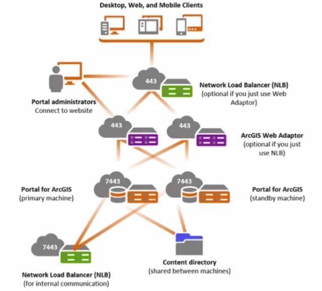
12 Portal High Availability

13 Portal High Availability Detail

14 Portal High Availability Detail (with hosting server)
15 ArcGIS Server Deployment
16 Silos, Sites & Clusters Silo Site Clusters LB LB LB Cluster A Cluster B Site Site Configuration Stores Configuration Store (shared) Configuration Store (shared) Use silos or small sites


17 Load Balancing options Multiple Machines w/3 rd Party Load Balancer Multiple Machines w/3 rd Party Load Balancer & Web Adaptors Use third party load balancer, if You have hardware load balancer and support Windows Authentication is not required Use the ArcGIS Web Adaptor You don t have a Load Balancer available If web-tier authentication is required

18 Security in Federated ArcGIS Server Closely integrates security and services from ArcGIS server to Portal for ArcGIS Provides single sign on to resources from Portal Required for organizations desiring to use SAML authentication for ArcGIS server services
19 Federating an ArcGIS Server site with your portal Benefits Single sign-on experience The server and the portal shsare the same user store Your existing and new ArcGIS Server services are automatically shared as portal items Host tiled map services and feature services published by users of the portal

20 HTTPS SSL is enabled by default with ArcGIS Server and is required for Portal Self-Signed Certificates vs. CA
21 Workload Separation LB LB LB LB ArcGIS Server ArcGIS Server ArcGIS Server ArcGIS Server Visualization & Imagery Visualization Analysis & Data Management Imagery Initial Deployment Complete GIS
22 Site design consideration Multi-node, high number of services Ensure require infrastructure resources Network stability NAS stability for ArcGIS Server and Portal config stores RAM CPU Avoid during the working hrs: Publishing high number services Adding/removing nodes Distribute recycle times
23 Site management consideration Identify unused services and reduce min (to 0 if possible) Tune slow services Provide best practices to the publishers Monitor resources: RAM and committed memory CPU Network latency All available as part of System Monitor,
24 Data Management

25 Data management strategy Centralized

26 Data management strategy Distributed
27 Data management strategy Replication Geodatabase export / import RDBMS export / import RDBMS replication ETL Tools (e.g. FME, Informatica) Geodatabase replication
28 Data management strategy Full GIS Capabilities Read / Write Desktop Server Desktop Server Limited GIS Capabilities Read Only Geodatabase Query Layer Geodatabase File Personal Enterprise RDBMS or Data Warehouse Oracle, SQL Server, etc. Netezza, Teradata, Hana, etc.

29 Data management strategy Production and Publication (external access) Pros: - Better security - Improved performance - Additional capacity Cons: - Requires replication - Additional hardware
30 Data System of Engagement On-premises Web GIS components in your own infrastructure System of Record Server GIS infrastructure Portal for ArcGIS Server Hosting server (ArcGIS Server) ArcGIS Data Store Connects to Data By reference Enterprise geodatabase Supports hosted data as well as the app and collaboration infrastructure; does not replace Server GIS infrastructure Supports publishing of authoritative data from enterprise geodatabases; can be used in conjunction with a Web GIS
31 Publication
32 Server Pattern App Web GIS Pattern App Services Web Maps & Layers Services portal
33 Publication Strategies The Role of Portal & Web Layers Portal GeoServices Geodata Web Layer Service Web Layer Service Feature Class Web Layer Service
34 Portal GeoServices Geodata Web Layer Web Layer Service Feature Class Web Layer
35 Portal GeoServices Geodata Active Wells Proposed Wells Wells Wells Wells by Status
36 Mobile
37 Today Collector user can download map areas to their device Choose area to download Download the map Disconnect and Collect data Connect and sync Future Field managers can improve field workflows by preparing maps for Collectors Create services/map Prepare offline map areas Share map areas
38 System Management

39 Environment Isolation Production: operational, real-time compute environment Staging: a separate, mirrored, pre-production environment Development: a limited scale and scope environment sufficient for the development of primary code and data modeling
40 Disaster recovery and replication The primary and standby environments must be duplicated The machine host names must be the same

41 To be successful
42 Succeeding with Web GIS Requires More Than Technology Technology People Process Planning
43 Partner with IT Executives Operations Knowledge Workers Mobile Workforce Analysts GIS Professionals Curate Content Author Maps Configure & Develop Apps IT Professionals Ensure Business Continuity Apply Security Enforce Governance
44 Know who you need at the table as you grow Subject Matter Experts Operational Data Experts Drive Requirements Power Users Knowledge Workers Executives Operations Mobile Workforce Analysts GIS Professionals Curate Content Author Maps Configure & Develop Apps IT Professionals Ensure Business Continuity Apply Security Enforce Governance


45 Monitor your Web GIS Don t set it and forget it Maintain SLAs Transparency Into System Tune System Stability & Availability Reduce Risks Optimize Performance Identify Bottlenecks Improved Capacity Planning Plan for change it s inevitable Network Hardware Web Server ArcGIS Server Geodatabase RDBMS
46 WRAP UP Options of deployment Cloud Portal Server Data Management Mobile System Management To successful of your ArcGIS implementation you required more than technology People Planning Process
47 SOLUTION MIX Technology: ArcGIS Platform Data: - Resources: Knowledge: System Architecture Design Strategies

48 STAY CONNECTED Esri Malaysia Training: Subscribe to our e-newsletters:
Enabling Web GIS. Dal Hunter Jeff Shaner
 Enabling Web GIS Dal Hunter Jeff Shaner Enabling Web GIS In Your Infrastructure Agenda Quick Overview Web GIS Deployment Server GIS Deployment Security and Identity Management Web GIS Operations Web GIS
Web GIS: Architectural Patterns and Practices. Shannon Kalisky Philip Heede
 Web GIS: Architectural Patterns and Practices Shannon Kalisky Philip Heede Web GIS Transformation of the ArcGIS Platform Desktop Apps Server GIS Web Maps Web Scenes Layers Web GIS Transformation of the
Web GIS Patterns and Practices
 FedGIS Conference February 24 25, 2016 Washington, DC Web GIS Patterns and Practices Philip Heede Jay Theodore Witt Mathot Web GIS Transformation of the ArcGIS Platform Desktop Apps Web Maps Web Scenes
Web GIS Deployment for Administrators. Vanessa Ramirez Solution Engineer, Natural Resources, Esri
 Web GIS Deployment for Administrators Vanessa Ramirez Solution Engineer, Natural Resources, Esri Agenda Web GIS Concepts Web GIS Deployment Patterns Components of an On-Premises Web GIS Federation of Server
Leveraging Web GIS: An Introduction to the ArcGIS portal
 Leveraging Web GIS: An Introduction to the ArcGIS portal Derek Law Product Management DLaw@esri.com Agenda Web GIS pattern Product overview Installation and deployment Configuration options Security options
Introduction to Portal for ArcGIS. Hao LEE November 12, 2015
 Introduction to Portal for ArcGIS Hao LEE November 12, 2015 Agenda Web GIS pattern Product overview Installation and deployment Security and groups Configuration options Portal for ArcGIS + ArcGIS for
Portal for ArcGIS: An Introduction. Catherine Hynes and Derek Law
 Portal for ArcGIS: An Introduction Catherine Hynes and Derek Law Agenda Web GIS pattern Product overview Installation and deployment Configuration options Security options and groups Portal for ArcGIS
Introduction to Portal for ArcGIS
 Introduction to Portal for ArcGIS Derek Law Product Management March 10 th, 2015 Esri Developer Summit 2015 Agenda Web GIS pattern Product overview Installation and deployment Security and groups Configuration
Web GIS & ArcGIS Pro. Zena Pelletier Nick Popovich
 Web GIS & ArcGIS Pro Zena Pelletier Nick Popovich Web GIS Transformation of the ArcGIS Platform Desktop Apps GIS Web Maps Web Scenes Layers Evolution of the modern GIS Desktop GIS (standalone GIS) GIS
Portal for ArcGIS: An Introduction
 Portal for ArcGIS: An Introduction Derek Law Esri Product Management Esri UC 2014 Technical Workshop Agenda Web GIS pattern Product overview Installation and deployment Security and groups Configuration
What Would John Snow Do (Today)? Part 1
? Part 1") What Would John Snow Do (Today)? Part 1 Tanya Bigos and Derek Law @Tanyabigos @GIS_Bandit Thurs Oct 19 th, 2017 Outline Overview of the ArcGIS Platform Whiteboard discussion Summary Questions A Whole New
What Would John Snow Do (Today)? Part 1 Tanya Bigos and Derek Law @Tanyabigos @GIS_Bandit Thurs Oct 19 th, 2017 Outline Overview of the ArcGIS Platform Whiteboard discussion Summary Questions A Whole New
ArcGIS Enterprise: What s New. Philip Heede Shannon Kalisky Melanie Summers Sam Williamson
 ArcGIS Enterprise: What s New Philip Heede Shannon Kalisky Melanie Summers Sam Williamson ArcGIS Enterprise is the new name for ArcGIS for Server What is ArcGIS Enterprise ArcGIS Enterprise is powerful
ArcGIS is Advancing. Both Contributing and Integrating many new Innovations. IoT. Smart Mapping. Smart Devices Advanced Analytics
 ArcGIS is Advancing IoT Smart Devices Advanced Analytics Smart Mapping Real-Time Faster Computing Web Services Crowdsourcing Sensor Networks Both Contributing and Integrating many new Innovations ArcGIS
ArcGIS. for Server. Understanding our World
 ArcGIS for Server Understanding our World ArcGIS for Server Create, Distribute, and Manage GIS Services You can use ArcGIS for Server to create services from your mapping and geographic information system
ArcGIS Earth for Enterprises DARRON PUSTAM ARCGIS EARTH CHRIS ANDREWS 3D
 ArcGIS Earth for Enterprises DARRON PUSTAM ARCGIS EARTH CHRIS ANDREWS 3D ArcGIS Earth is ArcGIS Earth is a lightweight globe desktop application that helps you explore any part of the world and investigate
What s New. August 2013
 What s New. August 2013 Tom Schwartzman Esri tschwartzman@esri.com Esri UC2013. Technical Workshop. What is new in ArcGIS 10.2 for Server ArcGIS 10.2 for Desktop Major Themes Why should I use ArcGIS 10.2
Demystifying ArcGIS Online. Karen Lizcano Esri
 Demystifying ArcGIS Online Karen Lizcano Esri An Integrated Web GIS Platform Desktop Web Device Powered by Services Managed via Portal Access from any Device Portal Server Online Content and Services ArcGIS
Web GIS Administration: Tips and Tricks
 EdUC 2017 July 8 th, 2017 Web GIS Administration: Tips and Tricks Geri Miller Agenda Concerns Acknowledged User Management Content Management Monitoring Licensing and logins Sophistication of IT support
ELF products in the ArcGIS platform
 ELF products in the ArcGIS platform Presentation to: Author: Date: NMO Summit 2016, Dublin, Ireland Clemens Portele 18 May 2016 The Building Blocks 18 May, 2016 More ELF users through affiliated platforms
Data Aggregation with InfraWorks and ArcGIS for Visualization, Analysis, and Planning
 Data Aggregation with InfraWorks and ArcGIS for Visualization, Analysis, and Planning Stephen Brockwell President, Brockwell IT Consulting, Inc. Join the conversation #AU2017 KEYWORD Class Summary Silos
Strategies for Integrating CAD and BIM in ArcGIS. Don Kuehne Esri 3D Product Manager: CAD/BIM/AEC
 Strategies for Integrating CAD and BIM in ArcGIS Don Kuehne Esri 3D Product Manager: CAD/BIM/AEC CAD Digital Drawing CAD in ArcGIS Desktop CAD in Desktop CAD as Data CAD as a Map EXPORT TO CAD Create and
How does ArcGIS Server integrate into an Enterprise Environment? Willy Lynch Mining Industry Specialist ESRI, Denver, Colorado USA
 How does ArcGIS Server integrate into an Enterprise Environment? Willy Lynch Mining Industry Specialist ESRI, Denver, Colorado USA wlynch@esri.com ArcGIS Server Technology Transfer 1 Agenda Who is ESRI?
Esri WebGIS Highlights of What s New, and the Road Ahead
 West Virginia GIS Conference WVU, Morgantown, WV Esri WebGIS Highlights of What s New, and the Road Ahead Mark Scott, Solutions Engineer, Esri Local Government Team May 5 th, 2016 West Virginia GIS Conference
ArcGIS Enterprise: What s New. Philip Heede Shannon Kalisky Melanie Summers Shreyas Shinde
 ArcGIS Enterprise: What s New Philip Heede Shannon Kalisky Melanie Summers Shreyas Shinde ArcGIS Enterprise is the new name for ArcGIS for Server ArcGIS Enterprise Software Components ArcGIS Server Portal
Changes in Esri GIS, practical ways to be ready for the future
 Changes in Esri GIS, practical ways to be ready for the future John Sharrard, Esri April 16, 2015 The only thing that is constant is change. Heraclitus, ca. 500 B.C. My story (of experiencing change) Changes
Innovation. The Push and Pull at ESRI. September Kevin Daugherty Cadastral/Land Records Industry Solutions Manager
 Innovation The Push and Pull at ESRI September 2004 Kevin Daugherty Cadastral/Land Records Industry Solutions Manager The Push and The Pull The Push is the information technology that drives research and
Introduction to ArcGIS Server Development
 Introduction to ArcGIS Server Development Kevin Deege,, Rob Burke, Kelly Hutchins, and Sathya Prasad ESRI Developer Summit 2008 1 Schedule Introduction to ArcGIS Server Rob and Kevin Questions Break 2:15
OFWIM 2017 Annual Conference What Does Web GIS Really Mean for Fish and Wildlife Agencies?
 Content Open Mapping OFWIM 2017 Annual Conference What Does Web GIS Really Mean for Fish and Wildlife Agencies? Imagery Spatial Analysis Mike Bialousz, Esri 3D Data Exploration Real-Time Apps Visualization
Introduction to ArcGIS Maps for Office. Greg Ponto Scott Ball
 Introduction to ArcGIS Maps for Office Greg Ponto Scott Ball Agenda What is Maps for Office? Platform overview What are Apps for the Office? ArcGIS Maps for Office features - Visualization - Geoenrichment
The Platform Generation. Derek Law and Ebony Wicks
 The Platform Generation Derek Law and Ebony Wicks GIS Provides the Framework and Process For Applying Geography Analysis and Interpretation Design and Planning Creating Understanding Modeling and Predicting
ArcGIS Enterprise: Administration Workflows STUDENT EDITION
 ArcGIS Enterprise: Administration Workflows STUDENT EDITION Copyright 2019 Esri All rights reserved. Course version 1.1. Version release date April 2019. Printed in the United States of America. The information
Geodatabase Replication for Utilities Tom DeWitte Solution Architect ESRI Utilities Team
 Geodatabase Replication for Utilities Tom DeWitte Solution Architect ESRI Utilities Team 1 Common Data Management Issues for Utilities Utilities are a distributed organization with the need to maintain
Discovery and Access of Geospatial Resources using the Geoportal Extension. Marten Hogeweg Geoportal Extension Product Manager
 Discovery and Access of Geospatial Resources using the Geoportal Extension Marten Hogeweg Geoportal Extension Product Manager DISCOVERY AND ACCESS USING THE GEOPORTAL EXTENSION Geospatial Data Is Very
DP Project Development Pvt. Ltd.
 Dear Sir/Madam, Greetings!!! Thanks for contacting DP Project Development for your training requirement. DP Project Development is leading professional training provider in GIS technologies and GIS application
Incorporating ArcGIS Pro in your Curriculum
 AAG, Boston 2017 April 5, 2017 Incorporating ArcGIS Pro in your Curriculum Geri Miller Agenda Concerns Acknowledged Learning curve ArcGIS Pro does not have all the tools (perception) Licensing and offline
The Pace of Change Is Accelerating Creating Many Challenges
 VISION The Pace of Change Is Accelerating Creating Many Challenges Evidence Threatening Our Natural World and Our Future as Humans Social Conflict Mass Migration Ocean Acidification Food Population Urbanization
No. of Days. Building 3D cities Using Esri City Engine ,859. Creating & Analyzing Surfaces Using ArcGIS Spatial Analyst 1 7 3,139
 Q3 What s New? Creating and Editing Data with ArcGIS Pro Editing and Maintaining Parcels Using ArcGIS Spatial Analysis Using ArcGIS Pro User Workflows for ArcGIS Online Organizations Q3-2018 ArcGIS Desktop
Esri Overview for Mentor Protégé Program:
 Agenda Passionate About Helping You Succeed Esri Overview for Mentor Protégé Program: Northrop Grumman CSSS Jeff Dawley 3 September 2010 Esri Overview ArcGIS as a System ArcGIS 10 - Map Production - Mobile
INSPIRE Shared Service
 INSPIRE Shared Service Creation and operation out of the box Petra Fritz (HZD), Michael Voigtländer (Esri Deutschland GmbH) INSPIRE Shared Service Agenda HZD backbone for a geodata infrastructure Implementing
Network Analysis Services in ArcGIS Enterprise. Deelesh Mandloi
 Network Analysis Services in ArcGIS Enterprise Deelesh Mandloi Slides from this demo theater http://esriurl.com/uc17nas Agenda Network Analyst concepts ArcGIS Enterprise publishing workflow - Geoprocessing
Spatial Analysis with Web GIS. Rachel Weeden
 Spatial Analysis with Web GIS Rachel Weeden Agenda Subhead goes here Introducing ArcGIS Online Spatial Analysis Workflows Scenarios Other Options Resources ArcGIS is a Platform Making mapping and analytics
Introduction to ArcGIS Server - Creating and Using GIS Services. Mark Ho Instructor Washington, DC
 Introduction to ArcGIS Server - Creating and Using GIS Services Mark Ho Instructor Washington, DC Technical Workshop Road Map Product overview Building server applications GIS services Developer Help resources
ArcGIS 10.1 An Overview of the System
 ArcGIS 10.1 An Overview of the System ArcGIS 10.1 An Overview of the System Damian Spangrud Director of Solutions, Esri Redlands, CA USA ArcGIS 10.1 Web Cloud Online Mobile Enterprise Desktop ArcGIS 10.1
No. of Days. ArcGIS 3: Performing Analysis ,431. Building 3D cities Using Esri City Engine ,859
 What s New? Creating Story Maps with ArcGIS Field Data Collection and Management Using ArcGIS Get Started with Insights for ArcGIS Introduction to GIS Using ArcGIS & ArcGIS Pro: Essential Workflow Migrating
No. of Days. ArcGIS Pro for GIS Professionals ,431. Building 3D cities Using Esri City Engine ,859
 What s New? Creating Story Maps with ArcGIS Field Data Collection and Management Using ArcGIS Get Started with Insights for ArcGIS Introduction to GIS Using ArcGIS & ArcGIS Pro: Essential Workflow Migrating
Data Aggregation with InfraWorks and ArcGIS for Visualization, Analysis, and Planning
 CI125230 Data Aggregation with InfraWorks and ArcGIS for Visualization, Analysis, and Planning Stephen Brockwell Brockwell IT Consulting Inc. Sean Kinahan Brockwell IT Consulting Inc. Learning Objectives
Arcgis Enterprise Performance And Scalability Best Practices
 Arcgis Enterprise Performance And Scalability Best Practices We have made it easy for you to find a PDF Ebooks without any digging. And by having access to our ebooks online or by storing it on your computer,
esri.com/apps Copyright 2017 Esri. All rights reserved.
 ArcGIS Apps esri.com/apps Copyright 2017 Esri. All rights reserved. 159913 G79379 ArcGIS Apps Survey123 for ArcGIS Included with ArcGIS Survey123 for ArcGIS Create survey style forms to capture accurate
European Location Framework data in the ArcGIS platform
 European Location Framework data in the ArcGIS platform Presentation to: Author: Date: INSPIRE Conference 2016 Clemens Portele 26 September 2016 Why ELF? Global (e.g. UN GGIM) Regional Europe (INSPIRE
June 19 Huntsville, Alabama 1
 June 19 Huntsville, Alabama 1 Real-Time Geospatial Data: The Fusion of PI and ArcGIS Enabling Smarter Facilities Management OSIsoft and Esri Mapping and Location Analytics Platform Supporting Your Use
Geo-Enabling Mountain Bike Trail Maintenance:
 Title Slide Geo-Enabling Mountain Bike Trail Maintenance: Enhanced Stewardship of the Fountainhead Mountain Bike Trail through GIS Technology Ruthann Ligon Follow the Trail Fountainhead Mountain Bike
Experiences and Directions in National Portals"
 FIG Seminar on e-land Administration Innsbruck/Austria 2-4 June 2004 "ESRI's Experiences and Directions in National Portals" Kevin Daugherty Cadastral/Land Records Manager ESRI Topic Points Technology
Esri User Conference 2018 Video Topics
 Esri User Conference 2018 Video Topics 3D GIS 3D Across ArcGIS 3D Analysis Tools in ArcGIS Pro 3D Cartographic Techniques: An Introduction 3D Data: Lidar Point Clouds and 3D Mesh 3D Feature and Sub-Surface
ArcGIS Pro Q&A Session. NWGIS Conference, October 11, 2017 With John Sharrard, Esri GIS Solutions Engineer
 ArcGIS Pro Q&A Session NWGIS Conference, October 11, 2017 With John Sharrard, Esri GIS Solutions Engineer jsharrard@esri.com ArcGIS Desktop The applications ArcGIS Pro ArcMap ArcCatalog ArcScene ArcGlobe
Esri and GIS Education
 Esri and GIS Education Organizations Esri Users 1,200 National Government Agencies 11,500 States & Regional Agencies 30,800 Cities & Local Governments 32,000 Businesses 8,500 Utilities 12,600 NGOs 11,000
Enabling ENVI. ArcGIS for Server
 Enabling ENVI throughh ArcGIS for Server 1 Imagery: A Unique and Valuable Source of Data Imagery is not just a base map, but a layer of rich information that can address problems faced by GIS users. >
CHAPTER 22 GEOGRAPHIC INFORMATION SYSTEMS
 CHAPTER 22 GEOGRAPHIC INFORMATION SYSTEMS PURPOSE: This chapter establishes the administration and use of to improve the quality and accessibility of Department s spatial information and support graphical
What s New in Collector for ArcGIS (Aurora)
") What s New in Collector for ArcGIS (Aurora) Derek Law (dlaw@esri.com) Esri Apps Product Management @GIS_Bandit Oct 10 th, 2018 Agenda Product overview Use cases Preparing data for Collector for ArcGIS
What s New in Collector for ArcGIS (Aurora) Derek Law (dlaw@esri.com) Esri Apps Product Management @GIS_Bandit Oct 10 th, 2018 Agenda Product overview Use cases Preparing data for Collector for ArcGIS
Troubleshooting Replication and Geodata Services. Liz Parrish & Ben Lin
 Troubleshooting Replication and Geodata Services Liz Parrish & Ben Lin AGENDA: Troubleshooting Replication and Geodata Services Overview Demo Troubleshooting Q & A Overview of Replication Liz Parrish What
ArcGIS Platform For NSOs
 ArcGIS Platform For NSOs Applying GIS and Spatial Thinking to Official Statistics Esri UC 2014 Demo Theater Applying GIS at the NSO Generic Statistical Business Process Model (GSBPM) 1 Specify Needs 2
Esri Training by Microcenter Prepare to Innovate. Microcenter Course Catalog
 Esri Training by Microcenter Prepare to Innovate 2015 Instructor-Led Courses Microcenter Course Catalog ArcGIS Foundational Courses Designed to meet the learning needs of professionals whose GIS experience
GPS Mapping with Esri s Collector App. What We ll Cover
 GPS Mapping with Esri s Collector App Part 1: Overview What We ll Cover Part 1: Overview and requirements Part 2: Preparing the data in ArcGIS for Desktop Part 3: Build a web map in ArcGIS Online Part
You are Building Your Organization s Geographic Knowledge
 You are Building Your Organization s Geographic Knowledge And Increasingly Making it Available Sharing Data Publishing Maps and Geo-Apps Developing Collaborative Approaches Citizens Knowledge Workers Analysts
A Vision for ArcGIS Applying Geography Everywhere
 A Vision for ArcGIS Applying Geography Everywhere WELCOME PURPOSE A Network of GIS Professionals Are Awakening the World to the Power of Web GIS You Your WORK Making a Difference Your Work Open Maps and
Connecting Communities. Jeff Peters - Esri
 Connecting Communities Jeff Peters - Esri Public Safety and Security Infrastructure Protection Officer Involved Shootings and Violent Crimes DHS Police Foundation Operation Centers Mail Theft Live Incident
Working with ArcGIS Online
 Esri International User Conference San Diego, CA Technical Workshops July 12, 2011 Working with ArcGIS Online Bern Szukalski, Deane Kensok Topics for this Session ArcGIS Online Overview ArcGIS Online Content
ArcGIS GeoAnalytics Server: An Introduction. Sarah Ambrose and Ravi Narayanan
 ArcGIS GeoAnalytics Server: An Introduction Sarah Ambrose and Ravi Narayanan Overview Introduction Demos Analysis Concepts using GeoAnalytics Server GeoAnalytics Data Sources GeoAnalytics Server Administration
Overview. Everywhere. Over everything.
 Cadenza Desktop Cadenza Web Cadenza Mobile Cadenza Overview. Everywhere. Over everything. The ultimate GIS and reporting suite. Provide, analyze and report data efficiently. For desktop, web and mobile.
One platform for desktop, web and mobile
 One platform for desktop, web and mobile Search and filter Get access to all data thematically filter data in context factually and spatially as well as display it dynamically. Export a selection or send
ArcGIS for Desktop. ArcGIS for Desktop is the primary authoring tool for the ArcGIS platform.
 ArcGIS for Desktop ArcGIS for Desktop ArcGIS for Desktop is the primary authoring tool for the ArcGIS platform. Beyond showing your data as points on a map, ArcGIS for Desktop gives you the power to manage
These modules are covered with a brief information and practical in ArcGIS Software and open source software also like QGIS, ILWIS.
 Online GIS Training and training modules covered are: 1. ArcGIS, Analysis, Fundamentals and Implementation 2. ArcGIS Web Data Sharing 3. ArcGIS for Desktop 4. ArcGIS for Server These modules are covered
How to Increase the Significance of your GIS
 How to Increase the Significance of your GIS Wade Kloos, GIS Director, Utah Department of Natural Resources wkloos@utah.gov 2014 Esri International User Conference July 17 How to Increase the Significance
Network Analysis with ArcGIS Online. Deelesh Mandloi Dmitry Kudinov
 Deelesh Mandloi Dmitry Kudinov Introductions Who are we? - Network Analyst Product Engineers Who are you? - Network Analyst users? - ArcGIS Online users? - Trying to figure out what is ArcGIS Online? Slides
ArcGIS Online Routing and Network Analysis. Deelesh Mandloi Matt Crowder
 ArcGIS Online Routing and Network Analysis Deelesh Mandloi Matt Crowder Introductions Who are we? - Members of the Network Analyst development team Who are you? - Network Analyst users? - ArcGIS Online
Crime Analyst Extension. Christine Charles
 Crime Analyst Extension Christine Charles ccharles@esricanada.com Agenda Why use Crime Analyst? Overview Tools Demo Interoperability With our old software it could take a police officer up to forty minutes
Innovation in Land Management: Integrated Solutions For National Cadastre Projects
 Success With GIS Innovation in Land Management: Integrated Solutions For National Cadastre Projects XXIII International FIG Congress Munich These documents are only complete, when used in connection with
Exelis and Esri Technologies for Defense and National Security. Cherie Muleh
 Exelis and Esri Technologies for Defense and National Security Cherie Muleh Cherie.Muleh@exelisinc.com ENVI IMAGERY AND DATA BECOME KNOWLEDGE > Add information from imagery to your GIS > Automated workflows
Spatial Data Availability Energizes Florida s Citizens
 NASCIO 2016 Recognition Awards Nomination Spatial Data Availability Energizes Florida s Citizens State of Florida Agency for State Technology & Department of Environmental Protection Category: ICT Innovations
An introduction to ArcGIS Maps for Office. Scott Ball & Mike Flanagan
 An introduction to ArcGIS Maps for Office Scott Ball & Mike Flanagan Main takeaways for today Adding the where to your analysis You can learn a lot when you unlock the power of geography in your analytics
Road Ahead: Linear Referencing and UPDM
 Road Ahead: Linear Referencing and UPDM Esri European Petroleum GIS Conference November 7, 2014 Congress Centre, London Your Work Making a Difference ArcGIS Is Evolving Your GIS Is Becoming Part of an
The Geo Web: Enabling GIS on the Internet IT4GIS Keith T. Weber, GISP GIS Director ISU GIS Training and Research Center.
 The Geo Web: Enabling GIS on the Internet IT4GIS Keith T. Weber, GISP GIS Director ISU GIS Training and Research Center In the Beginning GIS was independent The GIS analyst or manager was typically a oneperson
Development of a Web-Based GIS Management System for Agricultural Authorities in Iraq
 Development of a Web-Based GIS Management System for Agricultural Authorities in Iraq USCID Water Management Conference Phoenix, Arizona April 18, 2013 Gabriele Bonaiti Extension Program Specialist David
ArcGIS for INSPIRE. Marten Hogeweg Satish Sankaran
 ArcGIS for INSPIRE Marten Hogeweg Satish Sankaran Outline What is ArcGIS ArcGIS for INSPIRE Web GIS Case Studies Roadmap Q&A What is INSPIRE? INSPIRE is the legal framework for a European Spatial Data
GIS Integration to Maximo
 GIS Integration to Maximo Tuesday 15 th January 2008 Mahmoud Jaafar Systems Director GISTEC Agenda Introduction Why AMS & GIS Integration? ESRI GIS Enabling Technology. Integrating GIS & Maximo. What do
Law Enforcement Solutions and Applications
 ArcGIS for Solutions and Applications Solutions and Applications ArcGIS for Platform ArcGIS for Collection of solutions and applications for law enforcement. Built on the ArcGIS platform. For any named
IMPLEMENTING GOVERNMENT-WIDE ENTERPRISE GIS; THE FEDERATED MODEL
 IMPLEMENTING GOVERNMENT-WIDE ENTERPRISE GIS; THE FEDERATED MODEL James E. Mitchell, Ph. D. IT GIS Manager Louisiana Department of Transportation and Development presented at the ESRI International Users
ESRI Survey Summit August Clint Brown Director of ESRI Software Products
 ESRI Survey Summit August 2006 Clint Brown Director of ESRI Software Products Cadastral Fabric How does Cadastral fit with Survey? Surveyors process raw field observations Survey measurements define high-order
The Emerging Role of Enterprise GIS in State Forest Agencies
 The Emerging Role of Enterprise GIS in State Forest Agencies Geographic Information System (GIS) A geographic information system (GIS) is a computer software system designed to capture, store, manipulate,
What is GIS and How Can It Help Me?
 esri European User Conference Madrid 2011 What is GIS and How Can It Help Me? Jaime Nieves Ignacio Vázquez esri spain «Knowing where things are, and why, is essential to rational decision making.» Jack
GIS Workshop Data Collection Techniques
 GIS Workshop Data Collection Techniques NOFNEC Conference 2016 Presented by: Matawa First Nations Management Jennifer Duncan and Charlene Wagenaar, Geomatics Technicians, Four Rivers Department QA #: FRG
ArcGIS Runtime: Migrating Your Apps from ArcGIS Engine. Eric Bader Lucas Danzinger Mike Branscomb
 ArcGIS Runtime: Migrating Your Apps from ArcGIS Engine Eric Bader Lucas Danzinger Mike Branscomb Migrating to ArcGIS Runtime ArcGIS Engine ArcGIS Runtime AppStudio for ArcGIS Apps: Collector, Workforce,
Geography for the 2020 Round of Census
 Boundaries Key Census Data EA Id Population Male Female EA Id Area EA Id Num HH Avg HH size Geography for the 2020 Round of Census Linda Peters, Esri lpeters@esri.com Integration of Statistical and Geospatial
Key Points Sharing fosters participation and collaboration Metadata has a big role in sharing Sharing is not always easy
 Sharing Resources Geoff Mortson esri, Inc. SDI Solutions Team Key Points Sharing fosters participation and collaboration Metadata has a big role in sharing Sharing is not always easy Data Sharing is Good
October 2011 ArcGIS 10 for Server Functionality Matrix
 October 2011 ArcGIS 10 for Server Functionality Matrix Esri, 380 New York St., Redlands, CA 92373-8100 USA TEL 909-793-2853 FAX 909-793-5953 E-MAIL info@esri.com WEB www.esri.com Copyright 2011 Esri All
ArcGIS Runtime: Migrating from ArcGIS Engine. Rex Hansen
 ArcGIS Runtime: Migrating from ArcGIS Engine Rex Hansen Thank You to Our Sponsors Migrating from ArcGIS Engine to ArcGIS Runtime ArcGIS Runtime API: new and evolved workflows on all platforms Windows Linux
ArcGIS Earth an Intro
 ArcGIS Earth an Intro Chris Andrews Product Manager, 3D and ArcGIS Earth Brian Sims 3D Content Lead 3D across the Esri product family ArcGIS Pro 3D Analyst CityEngine ArcGIS for Server ArcGIS Online ArcGIS
Introduction to ArcGIS GeoAnalytics Server. Sarah Ambrose & Noah Slocum
 Introduction to ArcGIS GeoAnalytics Server Sarah Ambrose & Noah Slocum Agenda Overview Analysis Capabilities + Demo Deployment and Configuration Questions ArcGIS GeoAnalytics Server uses the power of distributed
Reducing Complex Spatial Data Management Needs in and Upstream Oil and Gas Operations Team. Jason Wilson GIS Business Analyst SM Energy
 Reducing Complex Spatial Data Management Needs in and Upstream Oil and Gas Operations Team Jason Wilson GIS Business Analyst SM Energy Agenda About Myself and SM Energy The Challenge The Goal Solution
7 GEOMATICS BUSINESS SOLUTIONS - ANNUAL REPORT 2006
 7 GEOMATICS BUSINESS SOLUTIONS - ANNUAL REPORT 2006 The Planning and Economic Development Committee recommends the adoption of the recommendation contained in the following report November 30, 2006, from
Getting Started with Community Maps
 Esri International User Conference San Diego, California Technical Workshops July 24, 2012 Getting Started with Community Maps Shane Matthews and Tamara Yoder Topics for this Session ArcGIS is a complete