Shoreline Assessment Job Aid National Oceanic and Atmospheric Administration NOAA Ocean Service Office of Response and Restoration Hazardous
|
|
|
- Gwen Sheena Cannon
- 5 years ago
- Views:
Transcription

1 Shoreline Assessment Job Aid National Oceanic and Atmospheric Administration NOAA Ocean Service Office of Response and Restoration Hazardous Materials Response Division
2 This job aid was produced and published by NOAA s Hazardous Materials Response Division (HAZMAT). All photographs, with exception of the one on the cover, where contributed by Miles O. Hayes and Jacqueline Michel of Research Planning, Inc. HAZMAT draws on two decades of experience in responding with the U.S. Coast Guard to spill emergencies and resolving the often longer-term problems presented by hazardous waste sites, garnering a reputation for rapid, yet carefully considered and cost-effective environmental protection decisions. U.S. DEPARTMENT OF COMMERCE National Oceanic and Atmospheric Administration NOAA Ocean Service Office of Response and Restoration/Hazardous Materials Response Division 7600 Sand Point Way N.E., Seattle, Washington (206) or orr.library@noaa.gov
3 Introduction... 1 Beach Profiles... 3 Photographs... 5 Surface Oil Distribution Percent Cover C Continuous...5 B Broken...5 P Patchy...6 S Sporadic...6 Surface Oiling Descriptors Thickness PO Pooled oil...7 CV Cover...7 CT Coat...8 ST Stain...8 FL Film...9 CONTENTS
4 CONTENTS Surface Oiling Descriptors Type FR Fresh oil MS Mousse TB Tarballs PT Patties TC Tar SR Surface oil residue AP Asphalt pavements Subsurface Oiling Descriptors Type SAP Subsurface asphalt pavement OP Oil-filled pores PP Partially filled pores OR Oil residue OF Oil film... 16
5 Sediment Types R Bedrock outcrop B Boulder C Cobble P Pebble G Granule S Sand M Mud Shoreline Types by ESI rank 1 Exposed rocky shores Exposed rocky platforms Fine-grained sand beaches Coarse-grained sand beaches Mixed sand and gravel beaches a Gravel beaches CONTENTS
6 CONTENTS Shoreline Types continued 6b Riprap structures Exposed tidal flats a Sheltered rocky shores b Sheltered man-made structures Sheltered tidal flats a Salt to brackish marshes b Freshwater marshes c Swamp d Mangroves Cleanup Methods Barriers/berms Physical herding Manual oil removal/cleaning Mechanical oil removal... 28
7 Cleanup Methods (continued) Sorbents Vacuum Debris removal Sediment reworking/tilling Vegetation cutting/removal Flooding (deluge) Low-pressure flushing High-pressure flushing High-pressure, hot-water flushing Percent Cover Estimation Charts CONTENTS
8
9 Shoreline Assessment Job Aid When oil contaminates shoreline habitats, responders must survey the affected areas to determine the appropriate response. Though general approvals or decision tools for use of shoreline cleanup methods may be developed during planning stages, responders must base specific cleanup recommendations on field data on the shoreline habitats, type and degree of shoreline contamination, and spill-specific physical processes. A shoreline assessment program is: a SYSTEMATIC approach that uses STANDARD terminology to collect data on shoreline oiling conditions and support decision making for shoreline cleanup. FLEXIBLE in terms of scale of the survey and detail of the data sets collected. MULTI-AGENCY, with TRAINED representatives from all interested parties who have authority to make decisions. NOAA published the Shoreline Assessment Manual (Report No. HAZMAT 97-4) which outlines methods for planning and conducting shoreline assessment and incorporating the results into the decision-making process for shoreline cleanup at oil spills. This job aid was developed to supplement the manual, providing a visual guide to many of the terms used during shoreline assessments. INTRODUCTION 1
10 2 INTRODUCTION Photographs are included for the following terminology: Oil distribution (as ranges in percent oil cover) Surface oiling thickness descriptors Surface oiling type descriptors Subsurface oiling type descriptors Sediment types Shoreline types Cleanup methods Beach terminology is defined on typical cross-sections of sand and gravel beaches. Percent cover estimation charts are also provided. At a spill, it is important to calibrate by having all team members visit a segment together and agree on how the oiling descriptors will be applied for the specific spill when used with the Shoreline Assessment Manual. This job aid is helpful for calibrating and promoting consistency among terms.
11 ELEVATION (cm) SCARP GRAVEL STORM BERM LHTS LHTS = Last High-Tide Swash BEACHFACE DISTANCE ALONG INTERTIDAL ZONE (m) GRAVEL BEACH WAVE-CUT ROCK PLATFORM LOW WATER BEACH PROFILES 3
12 4 BEACH PROFILES ELEVATION (cm) FOREDUNES LHTS = Last High-Tide Swash BACK BEACH BERM RUNNEL LHTS BERM TOP BERM BERM CREST DISTANCE ALONG INTERTIDAL ZONE (m) BEACHFACE SAND BEACH LOW WATER
 Broken 51-90%")
 B SURFACE OIL DISTRIBUTION Percent")
13 C Continuous % cover (seen here as black oil on light sand beach) Broken 51-90% cover (seen here as brown oil on tan sand beach) B SURFACE OIL DISTRIBUTION Percent Cover 5


14 6 SURFACE OIL DISTRIBUTION Percent Cover P Patchy 11-50% cover (seen here as black oil bands on a white sand beachface) Sporadic 1-10% cover (seen here as brown oil bands on a white sand beachface) S
 Cover oil or mousse > 0.")
 CV SURFACE OILING")
15 PO Pooled Oil fresh oil or mousse > 1 cm thick (seen here as accumulation around a large boulder) Cover oil or mousse > 0.1 cm to < 1 cm thick (seen here as oil covering sand beach surface and running into a small trench) CV SURFACE OILING DESCRIPTIONS Thickness 7

 Stain visible oil which cannot be")
16 8 SURFACE OILING DESCRIPTIONS Thickness CT Coat visible coating of oil < 0.1 cm can be scraped off with fingernail (seen here as a thin layer of oil on riprap) Stain visible oil which cannot be scraped off with fingernail (seen here as splotches on cobbles) ST
 SURFACE OILING DESCRIPTIONS Thickness")
17 FL Film transparent or iridescent sheen, or oily film (seen here as oil sheen floating on water) SURFACE OILING DESCRIPTIONS Thickness 9


18 10 SURFACE OILING DESCRIPTIONS Type FR Fresh Oil unweathered, liquid oil Mousse emulsified oil (seen here as brown oil coating cobbles) MS
 Patties")
 PT SURFACE OILING")
19 TB Tarballs discrete accumulations of oil < 10 cm in diameter (seen here scattered on sand beach) Patties discrete accumulations of oil > 10 cm in diameter (seen here as single black patty on sand beach) PT SURFACE OILING DESCRIPTIONS Type 11


20 12 SURFACE OILING DESCRIPTIONS Type TC Tar highly weathered oil of nearly solid consistency Surface Oil Residue non-cohesive, heavily oiled surface sediments characterized as soft, incipient asphalt pavements SR
 SURFACE OILING DESCRIPTIONS Type")
21 AP Asphalt Pavements cohesive, heavily oiled surface sediments (seen here as thick black deposit on a beachface) SURFACE OILING DESCRIPTIONS Type 13


22 14 SUBSURFACE OILING DESCRIPTIONS Type SAP Subsurface Asphalt Pavement a buried layer of hardened oil (seen here as black layer buried in a white sand beach) Oil-filled Pores pore spaces are completely filled with oil to the extent that oil flows out of sediments when disturbed (seen here as brown oil pebbles) OP


23 PP Partially Filled Pores pore spaces filled with oil, but generally does not flow out when disturbed Oil Residue sediments visibly oiled with black/brown coat or cover on clasts, but little or no accumulation of oil within pore spaces OR SUBSURFACE OILING DESCRIPTIONS Type 15

24 16 SUBSURFACE OILING DESCRIPTIONS Type OF Oil Film sediments are lightly oiled with an oil sheen or stain on the clasts.


25 R Bedrock Outcrop Boulder >256 mm in diameter B SEDIMENT TYPES 17


26 18 SEDIMENT TYPES C Cobble mm in diameter Pebble 4 64 in diameter P


27 G Granule 2 4 mm Sand mm S SEDIMENT TYPES 19

28 20 SEDIMENT TYPES M Mud silt and clay
")
 1 2")
29 Exposed Rocky Shores (also includes exposed seawalls) Exposed Rocky Platforms (also includes clay scarps) 1 2 SHORELINE TYPES 21


30 22 SHORELINE TYPES Fine-grained Sand Beaches 3 5 (also includes scarps in sand) 4 Course-grained Sand Beaches Mixed Sand and Gravel Beaches (also includes mixed sand and shell beaches)


31 Gravel Beaches (also includes shell beaches) Riprap Structures Exposed Tidal Flats 6a 6b 7 SHORELINE TYPES 23


32 24 SHORELINE TYPES Sheltered Rocky Shores Sheltered Man-made Structures Sheltered Tidal Flats 8a 8b 9


33 10a Salt to Brackish Marshes Freshwater Marshes 10b SHORELINE TYPES 25


34 26 SHORELINE TYPES 10c Swamps Mangroves 10d
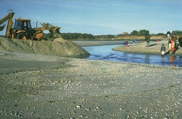
35 Barriers/Berms Physical Herding CLEANUP METHODS 27


36 28 CLEANUP METHODS Manual Oil Removal/Cleaning Mechanical Oil Removal


37 Sorbents Vacuum CLEANUP METHODS 29


38 30 CLEANUP METHODS Debris Removal Sediment Reworking/Tilling

")
39 Vegetation Cutting/Removal Flooding (deluge) CLEANUP METHODS 31


40 32 CLEANUP METHODS Low-pressure Flushing High-pressure Flushing

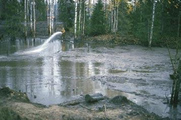
41 High-pressure, Hot-water Flushing CLEANUP METHODS 33
42 34 PERCENT COVER ESTIMATION CHARTS These charts are aids to help you estimate the percent oil coverage in the area you are observing. The black shading represents oil. Do not spend time trying to get a precise measure of percent cover; the four ranges listed are usually sufficient. The chart below would prove most helpful in oil band situations; the one on the following page is best for discrete oil deposits such as tarballs. Chart source: Owens, E.H., and G.A. Sergy. Field Guide to the Documentation and Description of Oiled Shorelines. Environment Canada, Edmonton, Alberta, Canada. March ISBN X.
43 PERCENT COVER ESTIMATION CHARTS 35
44 Donald L. Evans Secretary, U.S. Department of Commerce Vice Admiral Conrad C. Lautenbacher, Jr., USN (Ret.) Under Secretary for Oceans and Atmosphere and NOAA Administrator September 2002 Margaret A. Davidson Acting Assistant Administrator for Ocean Services and Coastal Zone Management, NOAA Ocean Service U.S. Department of Commerce National Oceanic and Atmospheric Administration NOAA Ocean Service
Shorelines and Diesel
 Shorelines and Diesel Rock Platforms (bedrock): A common shoreline type with a rocky environment that is both exposed and submerged from tide cycles. Platforms are generally horizontal and collect sediments
ssessments Ecoregional Assessment
 Standard 7: Select terrestrial, freshwater and marine conservation targets/biodiversity elements/features across multiple biological and spatial scales. Case Study: Shoreline Habitat Classification for
Extent and Degree of Shoreline Oiling: Deepwater Horizon (DWH) Oil Spill, Scott Zengel Research Planning, Inc. Tallahassee, Florida
 Oil Spill, Scott Zengel Research Planning, Inc. Tallahassee, Florida") Extent and Degree of Shoreline Oiling: Deepwater Horizon (DWH) Oil Spill, 2010 2013 Scott Zengel Research Planning, Inc. Tallahassee, Florida Background & Definitions SCAT survey data presented here SCAT
Extent and Degree of Shoreline Oiling: Deepwater Horizon (DWH) Oil Spill, 2010 2013 Scott Zengel Research Planning, Inc. Tallahassee, Florida Background & Definitions SCAT survey data presented here SCAT
Florida Panhandle and Alabama Beaches Welcome Spring Break: Free of Tar Balls at Last
 Florida Panhandle and Alabama Beaches Welcome Spring Break: Free of Tar Balls at Last Ping Wang, James H. Kirby III, and Jun Cheng Coastal Research Laboratory, Department of Geology, University of South
September 21, 2004 GeoInsight Project
 GeoInsight, Inc. GeoInsight, Inc. GeoInsight, Inc. 75 Gilcreast Road, Suite 210 319 Littleton Road, Suite 105 Corporate Ten Center Londonderry, NH 03053-3566 Westford, MA 01886 1781 Highland Avenue, Suite
3 SHORELINE CLASSIFICATION METHODOLOGY
 3 SHORELINE CLASSIFICATION METHODOLOGY Introduction The ESI scale, as described in Section 2, categorizes coastal habitats in terms of their susceptibility to spilled oil, taking into consideration a number
Shoreline and Climate Change Adaptation Alternatives for The Letter Parcel, Bolinas Lagoon
 Shoreline and Climate Change Adaptation Alternatives for The Letter Parcel, Bolinas Lagoon Scenic shoreline vista of Bolinas Lagoon and ridges, from Letter Parcel, March 2016 Peter Baye, Coastal Ecologist
The Marine Environment
 The Marine Environment SECTION 16.1 Shoreline Features In your textbook, read about erosional landforms, beaches, estuaries, longshore currents, and rip currents. For each statement below, write true or
Standardizing Visual Characterization of NAPL in Sediment Cores to Facilitate Remedial Decision-Making
 Standardizing Visual Characterization of NAPL in Sediment Cores to Facilitate Remedial Decision-Making Prepared for: Western Dredging Association Midwest Chapter Meeting Prepared by: Mike Ciarlo Jamie
Environmental Response Management Application
 Environmental Response Management Application Coastal Response Research Center Nancy Kinner, Michele Jacobi, Rob Braswell, Kurt Schwehr & Amy Merten RRT III May 14, 2008 1 Talk Outline Overview of Center
Coastal Response Research Center. Nancy Kinner University of New Hampshire (UNH) Michele Jacobi NOAA ORR. September 27, 2007
 Michele Jacobi NOAA ORR. September 27, 2007") Coastal Response Research Center Nancy Kinner University of New Hampshire (UNH) Michele Jacobi NOAA ORR September 27, 2007 1 Coastal Response Research Center (CRRC) CRRC is partnership between NOAA s Office
Coastal Response Research Center Nancy Kinner University of New Hampshire (UNH) Michele Jacobi NOAA ORR September 27, 2007 1 Coastal Response Research Center (CRRC) CRRC is partnership between NOAA s Office
University of New Hampshire Scholars' Repository
 University of New Hampshire University of New Hampshire Scholars' Repository Center for Coastal and Ocean Mapping Center for Coastal and Ocean Mapping 3-2009 Environmental Response Management Application
The Coast: Beaches and Shoreline Processes
 1 2 3 4 5 6 7 8 9 The Coast: es and Shoreline Processes Trujillo & Thurman, Chapter 10 Oceanography 101 Chapter Objectives Recognize the various landforms characteristic of beaches and coastal regions.
The Coast: Beaches and Shoreline Processes Trujillo & Thurman, Chapter 10
 The Coast: es and Shoreline Processes Trujillo & Thurman, Chapter 10 Oceanography 101 Chapter Objectives Recognize the various landforms characteristic of beaches and coastal regions. Identify seasonal
The Marine Environment
 The Marine Environment SECTION 16.1 Shoreline Features In your textbook, read about erosional landforms, beaches, estuaries, longshore currents, and rip currents. For each statement below, write or. 1.
Erich Gundlach, Ph.D.
 Oil Shoreline Interactions: Deepwater Horizon SETAC Boston, November 2011 Erich Gundlach, Ph.D. E-Tech International Inc. New York, USA ErichEti@ cs.com www.oil-spill-info.com What s Going On Shorelines
Weathering of Rocks. Weathering - Breakdown of rocks into pieces (sediment) 2 main types of weathering to rocks
 2 main types of weathering to rocks") Weathering of Rocks Weathering - Breakdown of rocks into pieces (sediment) 2 main types of weathering to rocks Mechanical weathering requires physical forces to break rocks into smaller pieces. Chemical
Weathering of Rocks Weathering - Breakdown of rocks into pieces (sediment) 2 main types of weathering to rocks Mechanical weathering requires physical forces to break rocks into smaller pieces. Chemical
Your teacher will show you a sample or diagram of each, and show you a settling column. Draw these, and label your diagrams (8 pts) Ungraded:
 Ungraded:") From Sand to Stone: How do we recognize and interpret sedimentary rocks in the rock record? (Based closely on the University of Washington ESS 101 Lab 5: Sedimentary Rocks) Introduction: This lab consists
From Sand to Stone: How do we recognize and interpret sedimentary rocks in the rock record? (Based closely on the University of Washington ESS 101 Lab 5: Sedimentary Rocks) Introduction: This lab consists
Map 4: Cowal Peninsula: Cluniter to Ardyne Point Map Content Descriptions
 Map 4: Cowal Peninsula: Cluniter to Ardyne Point Map Content Descriptions 1. Built Heritage and Archaeology A total of twenty four sites were recorded in the area covered by Map 4. Of these six were previously
Lecture Outline Wednesday - Friday February 14-16, 2018
 Lecture Outline Wednesday - Friday February 14-16, 2018 Quiz 2 scheduled for Friday Feb 23 (Interlude B, Chapters 6,7) Questions? Chapter 6 Pages of the Past: Sedimentary Rocks Key Points for today Be
Relatively little hard substrate occurs naturally in the
 CHAPTER FIVE Rock Habitats Relatively little hard substrate occurs naturally in the estuary, owing mainly to the vast quantities of fine sediment that have been deposited by the rivers. Rock habitat is
Aim and objectives Components of vulnerability National Coastal Vulnerability Assessment 2
 ASSESSING THE UTILITY OF GEOMORPHIC SENSITIVITY MAPPING ON THE ILLAWARRA COAST Pamela Abuodha, Christina Baker, Chris Sharples, Darren Skene and Colin Woodroffe Geoquest Research Centre, University of
Beach Pebbles Tell a Story
 Maine Geologic Facts and Localities September, 2000 Text by Joseph T. Kelley, Department of Agriculture, Conservation & Forestry 1 Introduction The smooth, sandy beaches of southern Maine are popular with
Geol 117 Lecture 18 Beaches & Coastlines. I. Types of Coastlines A. Definition:
 I. Types of Coastlines A. Definition: 1. Shore = narrow zone where ocean meets land (e.g. beach) 2. Coast is a broad area where both ocean and land processes act a. Includes onshore marshes, dunes, sea
Quantifying effects of oil on coastal dune vegetation. Thomas Miller and Elise Gornish Biological Science, Florida State University
 Quantifying effects of oil on coastal dune vegetation Thomas Miller and Elise Gornish Biological Science, Florida State University Natural History of Barrier Islands in the Northern Gulf Make up ~70% of
2 THE ENVIRONMENTAL SENSITIVITY INDEX MAPPING SYSTEM
 2 THE ENVIRONMENTAL SENSITIVITY INDEX MAPPING SYSTEM ESI maps are comprised of three general types of information: 1. Shoreline Classification ranked according to a scale relating to sensitivity, natural
SEDIMENTARY ROCKS. When mountains are first formed, they are tall and jagged like the Rocky Mountains on the west coast of North America.
 SEDIMENTARY ROCKS When mountains are first formed, they are tall and jagged like the Rocky Mountains on the west coast of North America. Over time (millions of years) mountains become old mountains like
March 11, 2011 Japanese Tsunami
 John Fassell March 11, 2011 Japanese Tsunami An earthquake occurred 30 miles under ground which lifted the seafloor Incoming wave as seen from shore Tsunami up to 130 feet tall in Miyako, JA that averaged
Objectives: Define Relative Age, Absolute Age
 S6E5. Students will investigate the scientific view of how the earth s surface is formed. c. Classify rocks by their process of formation. g. Describe how fossils show evidence of the changing surface
Geographic Response Plan Mapping and Digital Area Contingency Plan
 Geographic Response Plan Mapping and Digital Area Contingency Plan Ryan Druyor Digital ACP Coordinator Florida Fish and Wildlife Conservation Commission Fish and Wildlife Research Institute Background
Phillip Island Nature Parks Coastal Process Study 8 October 2014
 Phillip Island Nature Parks Coastal Process Study 8 October 2014 Project Overview Coastal Geology Basaltic and fragmented lavas, granite at Pyramid Rock and Cape Woolamai Weathered basalt (>10m thick)
C. STUDENT FIELD DATA SHEETS
 C. STUDENT FIELD DATA SHEETS Student Name Date Time Stream Location Parameter to find Your Group s Results Units trial trial average Transparency cm Water Temperature Air Temperature Weather N sunny N
Coastal and Marine Ecological Classification Standard (CMECS)
") Coastal and Marine Ecological Classification Standard (CMECS) Kathy Goodin, NatureServe EMECS, August 2011 Baltimore, MD 1 Outline Objectives & Process Classification Content Questions 2 Objectives Develop
Coastal and Marine Ecological Classification Standard (CMECS) Kathy Goodin, NatureServe EMECS, August 2011 Baltimore, MD 1 Outline Objectives & Process Classification Content Questions 2 Objectives Develop
BOUCHARD B120 RELEASE SHORELINE SEGMENT SUMMARY
 BOUCHARD B120 RELEASE SHORELINE SEGMENT SUMMARY 5 Lan Drive, Suite 200 Westford, Massachusetts 01886 Tel. (978) 692-1114 Fax (978) 692-1115 GeoInsight Project Number 3871-002 SEGMENT IDENTIFICATION: SEGMENT
Bishopville Prong Study
 Bathymetric and Sediment Assessment in the Bishopville Prong of St. Martin River Darlene V. Wells, Richard A. Ortt, Jr., and Stephen Van Ryswick Funded by MCBP 2011-2012 Implementation Grant Objectives
Depositional Environment
 Depositional Environment Sedimentary depositional environment describes the combination of physical, chemical and biological processes associated with the deposition of a particular type of sediment. Types
BOUCHARD B120 RELEASE SHORELINE SEGMENT SUMMARY
 BOUCHARD B120 RELEASE SHORELINE SEGMENT SUMMARY 5 Lan Drive, Suite 200 Westford, Massachusetts 01886 Tel. (978) 692-1114 Fax (978) 692-1115 GeoInsight Project Number 3871-002 SEGMENT IDENTIFICATION: SEGMENT
Regional-scale understanding of the geologic character and sand resources of the Atlantic inner continental shelf, Maine to Virginia
 Regional-scale understanding of the geologic character and sand resources of the Atlantic inner continental shelf, Maine to Virginia Workshop on Dredging, Beach Nourishment and Bird Conservation Atlantic
Sea-level Rise on Cape Cod: How Vulnerable Are We? Rob Thieler U.S. Geological Survey Woods Hole, MA
 Sea-level Rise on Cape Cod: How Vulnerable Are We? Rob Thieler U.S. Geological Survey Woods Hole, MA Outline Sea-level and coastal processes Past sea-level change Predictions for the future Coastal responses
American Institute of Professional Geologists South Dakota Section
 American Institute of Professional Geologists South Dakota Section 2015 Field Trip Guide Deadwood Formation in the Black Hills of South Dakota and Frac Sand Potential Saturday, September 12, 2015 1 Field
Edexcel 2 Landscape systems, processes and change
 Edexcel 2 Landscape systems, processes and change Area of the Spec Field Site Research areas Primary data collection Secondary data access Statistical analysis High and low Identifying of different Local
Sedimentary Rocks Chapter 6
 Sedimentary Rocks Chapter 6 I. What is a sedimentary rock? A. Sedimentary rock 1) Rock made of detrital sediments (such as sand) or inorganic/organic chemical precipitates (such as calcite) 2) Detrital
Do you think sediment transport is a concern?
 STREAM RESTORATION FRAMEWORK AND SEDIMENT TRANSPORT BASICS Pete Klingeman 1 What is Your Restoration Project Like? k? Do you think sediment transport is a concern? East Fork Lewis River, WA Tidal creek,
Cattaraugus Creek: A Story of Flowing Water and the Geology of the Channel It Flows Through Presentation to West Valley Citizen Task Force 4/27/16
 Cattaraugus Creek: A Story of Flowing Water and the Geology of the Channel It Flows Through Presentation to West Valley Citizen Task Force 4/27/16 Raymond C. Vaughan, Ph.D. What happens if you drop a
Black Point & Bihler Point
 Black Point & Bihler Point Conglomerate Photo: looking north toward end of Black Point (south of post 1) All of the rocks in this photo are conglomerate. Both Black Point and Bihler Point are formed from
GLG Chapter 7 Sedimentary Environments & Rocks
 GLG 101 - Chapter 7 Sedimentary Environments & Rocks Name Note, Oct 11: I ll be writing this study sheet over the next few days. Each day I will add questions until the entire chapter is done, hopefully
Jasper Beach, Machiasport, Maine
 Maine Geologic Facts and Localities June, 2000 Jasper Beach, Machiasport, Maine 44 o 38 30.28 N, 67 o 22 31.96 W Text by Joesph T. Kelley, Department of Agriculture, Conservation & Forestry 1 Map by USGS
COASTAL DYNAMICS VIRTUAL FIELD TRIP, NORTHEAST FLORIDA. Joann Mossa Department of Geography University of Florida
 COASTAL DYNAMICS VIRTUAL FIELD TRIP, NORTHEAST FLORIDA Joann Mossa Department of Geography University of Florida WHERE ARE WE GOING? In NE Florida (Flagler and St. Johns County, south of St. Augustine),
Exercise 3 Texture of siliciclastic sediments
 Exercise 3 Texture of siliciclastic sediments Siliciclastic sediments are derived from the weathering and erosion of preexisting rocks. Once a sedimentary particle is loosened from its parent rock, it
Use of Elevation Data in NOAA Coastal Mapping Shoreline Products. Coastal GeoTools April 1, 2015
 Use of Elevation Data in NOAA Coastal Mapping Shoreline Products Coastal GeoTools April 1, 2015 - NOAA s Coastal Mapping Program & CUSP - Shoreline Uses, Delineation Issues, Definitions - Current Extraction
Oyster Reef for Shoreline Stabilization and Restoration. Jason Kirkpatrick Conservation Program Manager MacDill AFB Tampa, Florida
 Oyster Reef for Shoreline Stabilization and Restoration Jason Kirkpatrick Conservation Program Manager MacDill AFB Tampa, Florida Interbay Penninsula Port of Tampa X The few remaining mangroves are being
Feet. SAND; clayey, fine grained; shells are common; rounded quartz grains. SHELLS; muddy; almost no sand, shells and fragments common
 SAND; clayey, fine grained; shells are common; rounded quartz grains SHELLS; muddy; almost no sand, shells and fragments common SAND; back to medium to fine; has a mottled appearance and looks burrowed;
Bowen s Chemical Stability Series
 Lab 5 - Identification of Sedimentary Rocks Page - Introduction Sedimentary rocks are the second great rock group. Although they make up only a small percentage of the rocks in the earth s crust (~5%)
Environment Canada. Environnement Canada
 Environment Canada Environnement Canada THE SCAT MANUAL A Field Guide to the Documentation and Description of Oiled Shorelines Second Edition Edward H. Owens Polaris Applied Sciences, Inc. and Gary A.
Sediment Management in the Coastal Bays
 Sediment Management in the Coastal Bays Introduction Need for ecosystem view of sediment management in Coastal Bays Island loss and restoration Navigation needs Habitat Trade offs Living Shoreline Requirements
Glacial Geology of Moose Point State Park, ME
 Geologic Site of the Month May, 2013 Glacial Geology of Moose Point State Park, Maine 44 o 25 59.18"N, 68 o 56 37.11"W Text and photos by Woodrow B. Thompson, Department of Agriculture, Conservation &
Chapter 6 Sedimentary and Metamorphic Rock
 Chapter 6 Sedimentary and Metamorphic Rock Weathering and Erosion Wherever rock is exposed at Earth s surface, it is continuously being broken down by weathering a set of physical and chemical processes
PROBABILITY-BASED ESTIMATION OF NEARSHORE HABITAT CHARACTERISTICS
 In: Proceedings of Puget Research '98 Conference, Seattle, WA. PROBABILITY-BASED ESTIMATION OF NEARSHORE HABITAT CHARACTERISTICS Allison Bailey, Helen Berry, Betty Bookheim Washington State Department
Adaptation to Sea Level Rise A Regional Approach
 Adaptation to Sea Level Rise A Regional Approach Project Partners: in Saco Bay, ME Peter Slovinsky, Marine Geologist Maine Geological Survey, Department of Conservation Project Funding from: Saco Bay Hazards
Chapter 11 10/30/2013. Mass Wasting. Introduction. Factors That Influence Mass Wasting. Introduction. Factors That Influence Mass Wasting
 Introduction Chapter 11 Mass wasting - The downslope movement of material resulting from the force of gravity. Mass Wasting Mass wasting results when the force of gravity acting on a slope exceeds the
Modeling habitat suitability for the European green crab using the ShoreZone mapping system
 Modeling habitat suitability for the European green crab using the ShoreZone mapping system Jodi N. Harney, Ph.D. and John R. Harper, Ph.D. Coastal and Ocean Resources Inc. Mary Morris, R.P. Bio. Archipelago
The Agents of Erosion
 The Agents of Erosion 1. Erosion & Deposition 2. Water 3. Wind 4. Ice California Science Project 1 1. Erosion and Deposition Erosion is the physical removal and transport of material by mobile agents such
Connecticut Coastal Management Program
 Connecticut Coastal Management Program Fact Sheet for SHORELINE FLOOD AND EROSION CONTROL STRUCTURES What are Shoreline Flood and Erosion Control Structures? The Connecticut General Statutes (CGS) define
DIVISION OF COASTAL MANAGEMENT TO STUDY CURRENT LONG-TERM EROSION RATES ADJACENT TO TERMINAL GROINS
 DIVISION OF COASTAL MANAGEMENT TO STUDY CURRENT LONG-TERM EROSION RATES ADJACENT TO TERMINAL GROINS North Carolina Department of Environmental Quality Division of Coastal Management February 22, 2018 N.
Sediment and sedimentary rocks Sediment
 Sediment and sedimentary rocks Sediment From sediments to sedimentary rocks (transportation, deposition, preservation and lithification) Types of sedimentary rocks (clastic, chemical and organic) Sedimentary
MEMORANDUM FOR SWG
 MEMORANDUM FOR SWG-2007-1623 Subject: Jurisdictional Determination (JD) for SWG-2007-1623 on Interdunal Wetlands Adjacent to Traditional Navigable Waters (TNWs) Summary The U.S. Environmental Protection
BOUCHARD B120 RELEASE SHORELINE SEGMENT SUMMARY
 BOUCHARD B120 RELEASE SHORELINE SEGMENT SUMMARY 5 Lan Drive, Suite 200 Westford, Massachusetts 01886 Tel. (978) 692-1114 Fax (978) 692-1115 GeoInsight Project Number 3871-002 SEGMENT IDENTIFICATION: SEGMENT
Estimated Sediment Volume: Bridge Street Dam Impoundment, Royal River, Yarmouth, Maine
 University of Southern Maine USM Digital Commons Publications Casco Bay Estuary Partnership (CBEP) 2015 Estimated Sediment Volume: Bridge Street Dam Impoundment, Royal River, Yarmouth, Maine Stantec Follow
Ch 10 Deposition Practice Questions
 1. Base your answer to the following question on the data table below. Six identical cylinders, A through F, were filled with equal volumes of sorted spherical particles. The data table shows the particle
Australian Coastal Councils Conference
 Australian Coastal Councils Conference 11 March 2015 Estimating Future Coastal Inundation and Erosion Hazards Dr Andrew McCowan Dr Christine Lauchlan-Arrowsmith Warwick Bishop Background Victorian Future
Sediment. Weathering: mechanical and chemical decomposition and disintegration of rock and minerals at the surface
 Sediment Some basic terminology Weathering: mechanical and chemical decomposition and disintegration of rock and minerals at the surface Erosion: removal of weathered rock and minerals from one place to
Mapping Coastal Change Using LiDAR and Multispectral Imagery
 Mapping Coastal Change Using LiDAR and Multispectral Imagery Contributor: Patrick Collins, Technical Solutions Engineer Presented by TABLE OF CONTENTS Introduction... 1 Coastal Change... 1 Mapping Coastal
SEGMENTED BREAKWATERS AND THEIR USE IN COASTAL LOUISIANA
 SEGMENTED BREAKWATERS AND THEIR USE IN COASTAL LOUISIANA Prepared by: Louisiana Coastal Protection and Restoration Authority Engineering Division March 2016 The geology of Louisiana s coastal zone is intimately
Materials. Use materials meeting the following.
 208.01 Section 208. SOIL EROSION AND SEDIMENTATION CONTROL 208.01 Description. Install and maintain erosion and sedimentation controls to minimize soil erosion and to control sedimentation from affecting
Topic 6: Weathering, Erosion and Erosional-Deposition Systems (workbook p ) Workbook Chapter 4, 5 WEATHERING
 Workbook Chapter 4, 5 WEATHERING") Topic 6: Weathering, Erosion and Erosional-Deposition Systems (workbook p. 95-125) Workbook Chapter 4, 5 THE BIG PICTURE: Weathering, erosion and deposition are processes that cause changes to rock material
Topic 6: Weathering, Erosion and Erosional-Deposition Systems (workbook p. 95-125) Workbook Chapter 4, 5 THE BIG PICTURE: Weathering, erosion and deposition are processes that cause changes to rock material
Stream Simulation: A Simple Example
 Stream Simulation: A Simple Example North Thompson Creek, CO Paul T. Anderson U.S.D.A. Forest Service Here s How We Started May 2011 2-1 USDA-Forest Service Here s How We Finished Forest Service Aquatic
Submerged Oil Recovery Systems and Recommendations. RDC Kurt Hansen Regional Response Team 5 Minneapolis, MN April 30, 2014
 Submerged Oil Recovery Systems and Recommendations RDC Kurt Hansen Regional Response Team 5 Minneapolis, MN April 30, 2014 Outline Submerged Oil Background Past R&D Related Efforts Project at USCG RDC
Figure 1 The map shows the top view of a meandering stream as it enters a lake. At which points along the stream are erosion and deposition dominant?
 1. In which type of climate does chemical weathering usually occur most rapidly? 1. hot and dry 3. cold and dry 2. hot and wet 4. cold and wet 2. Figure 1 The map shows the top view of a meandering stream
Fish Passage at Road Crossings
 Fish Passage at Road Crossings 1 Crossing Design Workshop Outline 1:00 to 2:00 Intro, Design Overview, Channel Width 2:00 to 2:15 Break 2:15 to 3:15 No-Slope, Stream Simulation Design 3:15 to 3:30 Break
Essential Questions. What is erosion? What is mass wasting?
 Erosion Essential Questions What is erosion? What is mass wasting? What is Erosion? Erosion The transportation of sediment from one area to another Caused mainly by running water but also caused by glaciers,
Virginia Shoreline Mapping Tools
 Virginia Shoreline Mapping Tools December 15, 2017 Karen Duhring Center for Coastal Resources Management Virginia Institute of Marine Science College of William & Mary Virginia Shoreline Mapping Tools
APPENDIX F SEDIMENT DEPOSITION AND HABITAT CONVERSION ANALYSIS
 APPENDIX F SEDIMENT DEPOSITION AND HABITAT CONVERSION ANALYSIS San Dieguito Lagoon W-19 Restoration Project Draft EIR March 2017 Appendices Introduction: The following is an analysis to provide the volume
KEYWORDS: erosion shoreline change nourishment community issues
 UNC Coastal Studies Institute 1 TITLE: Sand, Soil, Sediment Selection for Beach Nourishment KEYWORDS: erosion shoreline change nourishment community issues ABSTRACT: North Carolina s barrier islands are
Module 9 Sedimentary Rocks
 Module 9 Sedimentary Rocks SEDIMENTARY ROCKS Rocks formed from material derived from preexisting rocks by surfacial processes followed by diagenesis There are two main classes of sedimentary rocks Clastic
Sedimentary Rocks, our most Valuable Rocks. Or, what you will probably find when you are outdoors exploring.
 Sedimentary Rocks, our most Valuable Rocks Or, what you will probably find when you are outdoors exploring. Sedimentary rocks give us evidence to earth s earlier history. We look at processes happening
Holocene evolution of Dahab coastline Gulf of Aqaba, Sinai Peninsula, Egypt 1
 Holocene evolution of Dahab coastline Gulf of Aqaba, Sinai Peninsula, Egypt 1 Magdy Torab* 2 * Prof. of Geomorphology, Department of Geography, Damanhour University, Egypt 3 E-mail: magdytorab@hotmail.com.
GEOL.3250 Geology for Engineers Sedimentary & Metamorphic Rocks
 GEOL.3250 Geology for Engineers Sedimentary & Metamorphic Rocks Name I. Introduction The bulk of the earth's crust is composed of relatively few minerals. These can be mixed together, however, to give
Lecture Outlines PowerPoint. Chapter 13 Earth Science 11e Tarbuck/Lutgens
 Lecture Outlines PowerPoint Chapter 13 Earth Science 11e Tarbuck/Lutgens 2006 Pearson Prentice Hall This work is protected by United States copyright laws and is provided solely for the use of instructors
BOUCHARD B120 RELEASE SHORELINE SEGMENT SUMMARY
 BOUCHARD B120 RELEASE SHORELINE SEGMENT SUMMARY 5 Lan Drive, Suite 200 Westford, Massachusetts 01886 Tel. (978) 692-1114 Fax (978) 692-1115 GeoInsight Project Number 3871-002 SEGMENT IDENTIFICATION: SEGMENT
Professors Dean and Dalrymple are also authors of the well-known Water Wave Mechanics for Engineers and Scientists.
 COASTAL PROCESSES The world s coastlines, dividing land from sea, are geological environments unique in their composition and the physical processes affecting them. Humans have been building structures
200 Meters Down Topic: Ocean Zones (5 th 8 th grade)
") 200 Meters Down Topic: Ocean Zones (5 th 8 th grade) by Lodge 200 Meters Down Have you people heard about the plankton? Just tiny algae and it s floating, right What about the nekton like jellyfish? They
200 Meters Down Topic: Ocean Zones (5 th 8 th grade) by Lodge 200 Meters Down Have you people heard about the plankton? Just tiny algae and it s floating, right What about the nekton like jellyfish? They
Sediments and. Sedimentary Rocks
 Sediments and Sedimentary Rocks Bottom Line Sedimentary rocks form from particles accumulated in sedimentary layers Sedimentary layers can be formed by clastic or detrital particles (e.g., sand grains,
Clyde River Landslide
 Clyde River Landslide Department of Geology, Perkins Hall, University of Vermont, Burlington, VT 05405 Abstract: This paper investigates a landslide on the Clyde River in Newport, Vermont. The landslide
BOUCHARD B120 RELEASE SHORELINE SEGMENT SUMMARY
 BOUCHARD B120 RELEASE SHORELINE SEGMENT SUMMARY 5 Lan Drive, Suite 200 Westford, Massachusetts 01886 Tel. (978) 692-1114 Fax (978) 692-1115 GeoInsight Project Number 3871-002 SEGMENT IDENTIFICATION: SEGMENT
Habitat Mapping in The Hauraki Gulf Marine Park. Dan Breen
 Habitat Mapping in The Hauraki Gulf Marine Park Dan Breen Outline 1. Intro Habitat mapping 2. Coastal marine habitats and marine protected areas in the New Zealand Territorial Sea: a broad scale gap analysis
Sediment and Sedimentary rock
 Sediment and Sedimentary rock Sediment: An accumulation of loose mineral grains, such as boulders, pebbles, sand, silt or mud, which are not cemented together. Mechanical and chemical weathering produces
netw rks Guided Reading Activity Essential Question: How does geography influence the way people live? Earth's Physical Geography
 Guided Reading Activity Lesson 1 Earth and the Sun Essential Question: How does geography influence the way people live? Looking at Earth Directions: What are the layers that make up Earth? Use your textbook
Guided Notes Rocks & Minerals
 Guided Notes Rocks & Minerals is Mineral 1.What is a Mineral Tests 2.Mineral Properties Cycle 3.Rock Rocks 4.Igneous Rocks 5.Sedimentary Rocks 6. Metamorphic Rocks Reference Tables K. Coder 2015 12. What
1 Shoreline Landforms 2. 2 Emergent v. Submergent 2. 3 Wavecutting 3. 4 Planview 4. 5 Marine Terraces 5. 6 California 7. 7 Tombolos, Sea Stacks 8
 Shorelines November 9, 2008 Contents 1 Shoreline Landforms 2 2 Emergent v. Submergent 2 3 Wavecutting 3 4 Planview 4 5 Marine Terraces 5 6 California 7 7 Tombolos, Sea Stacks 8 8 Active Processes 9 9 Emergence
Paleo Lab #4 - Sedimentary Environments
 Paleo Lab #4 - Sedimentary Environments page - 1. CHARACTERISTICS OF SEDIMENT Grain size and grain shape: The sizes and shapes of sedimentary particles (grains) are modified considerably during their transportation