Restoration of a boulder reef in Kattegat a numerical study of the design parameters and impact on sediment transport
|
|
|
- Reynard McDowell
- 5 years ago
- Views:
Transcription


1 Restoration of a boulder reef in Kattegat a numerical study of the design parameters and impact on sediment transport S. Niemann, K. Bundgaard, et. al. DHI Water Environment Health, Denmark Boulder reef restoration project. Recreation of natural habitat for fish, lobsters and other crustaceans. Long term stability of the reef ensured through numerical modelling of design parameters. Impacts on the nearby and local morphology of the seabed determined through numerical modelling of sediment transport. Sustainable solution reached. Dredging site in Kattegat, Denmark

2 Background Reefs in shallow water is a rare type of reef in Denmark only 0.01 % is left. This reef was subject of stone fishing for harbours. Especially large stones was removed. Remaining reef subject to erosion. Flora and fauna degenerating Restauration project launched supported by EU and Danish authorities to restore reef
3 Facts on the restoration 7 acres of reef to be restored Extensive field investigations prior to actual restoration. Extensive numerical investigations on waves, hydrodynamics and sediment transport m 3 of stones mainly from norway and sweeden to be used. Project to be carried out slowly in while closely monoring the migration of flora and fauna into the reef. All progress and further information can be viewed at
4 DHI investigations DHI was commisioned to do hydrographic and sediment transport modelling. The purpose of the hydrophic modelling was to establish knowledge of the hydronamics in the area including waves and currents for normal conditions and extreme conditions. This includes design data Modelling of sediment transport was for the purpose of determining a layout for the reef where a minimum of erosion and accretion whould occur.

5 Hydrographic conditions The current in the Kattegat estuary is often 3 dimensional and the effect of meteorology, salinity, temperature and global circulations has to be taken into account. This includes the flow in and out of the Baltic sea. The reef itself is very local and needs special care when modelling. Waves will break over it and wave driven currents will be present. Modelling the reef will require good bathymetric and sediment data and results from a global hydrodynamic 3D model.


6 Global hydrodynamic model


7 Local hydrodynamic model

8 Wave model


 with")
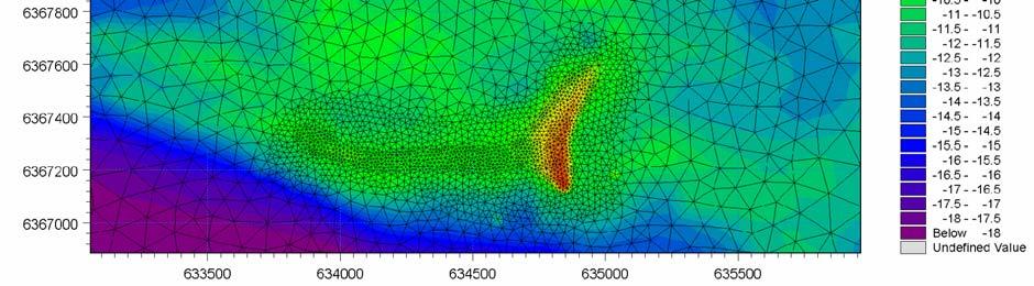
9 Physical conditions for new layout Bathymetry of Læsø Trindel. The restoration area is shown (right) with and without the new structures.
10 Physical conditions for new layout Water depths are generally between 8m and 12m in the main part of the plateau. Locally the water depth is only 4m at the top of the reef. Four different structures are proposed by the designer Orbicon A/S The Western and Central structures are areas where the sea bed to 1.5 m below mean sea level (MSL). level is increased approximately 1 m with singular pillars reaching up The Eastern structure is stabilizing the shallowest part of the existing reef areas with plateaus of boulders in different levels up to 1 m below MSL. The Wall structure is stabilizing the northern part of the shallowest area reaching to 4 m below mean sea level
 for the period 1996-2005. Wind direction is defined as coming from.")
11 Physical conditions for new layout Wind rose (hindcast wind data) north of Læsø (LONG ;LAT ) for the period Wind direction is defined as coming from.


12 Model considerations at the reef Calm wheather flow may be stratified and use of 3D model required with no wave influence. Storms Flow will be uniform and use of 2D model including wave driven currents will be used. This includes wave modelling. 3D surface flow during storm 2D depth averaged flow during storm


13 Validation currents regional model Comparison of measured and modelled current in January 2005 from Læsø Rende West
14 Validation waves
15 Simulation plan 10 years of 3D hydrodynamics and waves for design purposes in global model. 10 years of 3D hydrodynamics and waves in the local model. 5 hydrodynamic scenarios in 3D for the local model. For each layout 4 hydrodynamic scenarios in 2D and 4 wave scenarios in the local model. For each layout. Sediment transport calculations for the selected 9 scenarios in 2D and 3D. For each layout.
![Design data Simulation period 1997-2006 (10 years) Current speed statistics for 1997-2006 at position A-F Current Speed [m/s] Max Mean](/docs-images/92/110706270/images/16-0.jpg "Std. Dev. Point A surface 2.01 0.60 0.32 Point A bottom (4m) 0.98 0.22 0.14 Point B surface 1.79 0.48 0.27 Point B bottom (9m) 0.82 0.")
 0.88 0.15 0.11 Point F surface 1.71 0.46 0.26 Point F bottom (9m) 0.76 0.")
16 Design data Simulation period (10 years) Current speed statistics for at position A-F Current Speed [m/s] Max Mean Std. Dev. Point A surface Point A bottom (4m) Point B surface Point B bottom (9m) Point C surface Point C bottom (7m) Point D surface Point D bottom (8m) Point E surface Point E bottom (8m) Point F surface Point F bottom (9m)
17 Design data extrema values The key results of the extreme value analysis of depth integrated current with 10- and 50- year return periods for the 6 positions A-F on Læsø Trindel Return Period [years] A B C D E F Depth [m] Current speed [m/s] Current speed [m/s] The key results of the extreme value analysis of surface current with 10- and 50-year return periods for the 6 positions A-F on Læsø Trindel Return Period A B C D E F [years] Depth [m] Current speed [m/s] Current speed [m/s]
18 Sediment transport approach 9 events choesen. Four storms and four conditions with gentle weather and one purely tidal case. Events chosen on the basis of the 10 years data of wind, waves and currents at the reef. For calm periods a 3D approach was used due to stratification For storm events a 2D approach was used assuming fully mixed water column at the reef All simulations carried out using MIKE21/3 FM fully coupled hydrodynamic model. Sediment transport model was MIKE 21 ST based on a tabular approach using a quasi 3D description. Based on surveys 4 grain size diameters were considered. 0.2mm, 2mm, 20mm and 100mm representative for different water depths.
19 Period Case 1: Strong wind from W 29/11/ :00 AM - 03/12/ :00 PM Case 2: Medium-strong wind from S-SW 26/12/ :00 PM - 29/12/ :00 PM Case 3: Medium-strong wind from S-SE 9/1/ :00 PM - 12/1/ :00 PM Case 4: Medium wind from W 17/2/1998 0:00 AM - 20/2/1998 0:00 AM Peak wind speed [m/s] Wind direction at peak wind speed [degr. N] Selected events Average wind speed [m/s] Average wind direction (wind speed > 8 m/s) [degr. N] Period Case 5: Strong NW current in upper layer, varying direction in lower layer 13/10/ :00 AM - 14/10/ :00 PM Case 6: Medium W-NW current in upper layer, varying direction in lower layer 05/10/2005 4:00 PM - 06/10/2005 4:00 PM Case 7: NW-SE current. Uniform flow direction over depth. Weak-medium current speeds 10/1/2005 3:00 AM - 11/1/2005 3:00 AM Case 8: NW-SE current. Medium current speeds 27/3/2005 4:00 AM - 28/3/2005 4:00 AM Maximum current speed, surface [m/s] Current directions, surface [degr. N] Period Varying tidal variation Maximum tidal amplitude [m] Minimum tidal amplitude [m] 28/08/2005 0:00 AM /09/2005 0:00 AM


 2 mm >11 m 7 (<")
20 Sediment distribution Water depth Finest sediment fraction present Sediment grain size in modelling <7 m 4-5 ( mm) 20 mm 7-11 m 6 (2-20 mm) 2 mm >11 m 7 (< 2 mm) 0.2 mm
")
 at the peak of the case 1")
21 Hydrodynamic results Instantaneous flow field for existing conditions (upper figure) compared to the situation including design 1 (lower figure) at the peak of the case 1 storm.

22 Hydrodynamic results Deviation in flow speed flow speed between the situation including the new structures and the existing conditions at the peak of the case 1 storm


23 Sediment results Magnitude of sediment transport at locations A (upper figure, water depth approximately 9m) and B (lower figure, water depth approximately 4 m) at LæsøTrindel. Medium strong wind from S-SE for grain sizes d50=0.2 mm, 2 mm, and 20mm.
24 Sediment results First reef design Existing conditions Area covered Accumulated net sediment transport rates during the severe storm for water depths above 11 m (sediment grain size 0.2 mm, upper figures), water depths 7-11 m (sediment grain size 2.0 mm, middle figures) and water depths below 7 m (sediment grain size 20.0 mm, lower figures). Triangle indicates area, where submarine structures created by leaking gases have been found.

 and")

25 Sediment results Erosion and deposition pattern in reef area for calculation with sediment grain size 2.0 mm. Existing conditions (upper figure) and including reef design 1 (lower figure). Representative for water depths between 7 and 11 m.
26 Conclusions Design data based on 10 years of model data was produced including waves and 3D currents. A comprehensive study was carried out for 9 weather conditions to determine impacts of reef layouts. Accumulated sediment transport rates are low. Annual sediment transport rates is 5-7 m 3 /m on the plateau and 5-15 m 3 /m in the deeper areas. Little impact from the proposed structures on the transport. Only very locally a decrease in the transport rates are seen. It was shown that the designers have large degrees of fredom to design the reef favourable for the flora and fauna. The model was proven to be a very powerfull design tool in areas of great complexity.
Appendix G.19 Hatch Report Pacific NorthWest LNG Lelu Island LNG Maintenance Dredging at the Materials Offloading Facility
 Appendix G.19 Hatch Report Pacific NorthWest LNG Lelu Island LNG Maintenance Dredging at the Materials Offloading Facility Project Memo H345670 To: Capt. David Kyle From: O. Sayao/L. Absalonsen December
F E H M A R N B E L T H Y D R O G R A P H Y
 F E H M A R N B E L T H Y D R O G R A P H Y Final Report FEHMARNBELT FIXED LINK HYDROGRAPHIC SERVICES (FEHY) Marine Soil - Baseline Sea Bed Morphology of the Fehmarnbelt Area E1TR0056 - Volume I Prepared
Appendix G.18 Hatch Report Pacific NorthWest LNG Lelu Island LNG Potential Impacts of the Marine Structures on the Hydrodynamics and Sedimentation
 Appendix G.18 Hatch Report Pacific NorthWest LNG Lelu Island LNG Potential Impacts of the Marine Structures on the Hydrodynamics and Sedimentation Patterns Project Memo H345670 To: Capt. David Kyle From:
Forecast of Nearshore Wave Parameters Using MIKE-21 Spectral Wave Model
 Forecast of Nearshore Wave Parameters Using MIKE-21 Spectral Wave Model Felix Jose 1 and Gregory W. Stone 2 1 Coastal Studies Institute, Louisiana State University, Baton Rouge, LA 70803 2 Coastal Studies
Eutrophication (H01.05), Contaminant pollution (H01.05), Contaminant pollution (H03),
, Contaminant pollution (H01.05), Contaminant pollution (H03),") English name: Code in HUB: Submarine structures made by leaking gases 1180 Characteristic species: Polycirrus norwegicus, Kellia suborbicularis Past and Current Threats (Habitat directive Future Threats
English name: Code in HUB: Submarine structures made by leaking gases 1180 Characteristic species: Polycirrus norwegicus, Kellia suborbicularis Past and Current Threats (Habitat directive Future Threats
Environmental impact assessment study of the new offshore dumping sites for Šventoji port in Lithuania
 Environmental impact assessment study of the new offshore dumping sites for Šventoji port in Lithuania Introduction Summary In 2003 Lithuanian Ministry of Transport initiated the preparation of feasibility
FOWPI Metocean Workshop Modelling, Design Parameters and Weather Windows
 FOWPI Metocean Workshop Modelling, Design Parameters and Weather Windows Jesper Skourup, Chief Specialist, COWI 1 The Project is funded by The European Union Agenda 1. Metocean Data Requirements 2. Site
The use of MIKE21 to study the. barrier beach system of Inner Dingle Bay, Co. Kerry, Ireland. Dr. Michael O Shea Malachy Walsh and Partners
 The use of MIKE21 to study the morphodynamic evolution of the mid-bay barrier beach system of Inner Dingle Bay, Co. Kerry, Ireland Dr. Michael O Shea Malachy Walsh and Partners Contents Why Study Morphodynamics
EIA FOR THE FEHMARNBELT CROSSING THE WORLD S LONGEST IMMERSED TUNNEL
 EIA FOR THE FEHMARNBELT CROSSING THE WORLD S LONGEST IMMERSED TUNNEL Ida Brøker 1, Ian Sehested Hansen 2, Anne Lise Middelboe 3 An 18 km long immersed tunnel is going to be built between Denmark and Germany.
Texas A & M University and U.S. Bureau of Reclamation Hydrologic Modeling Inventory Model Description Form
 Texas A & M University and U.S. Bureau of Reclamation Hydrologic Modeling Inventory Model Description Form JUNE, 1999 Name of Model: Two-Dimensional Alluvial River and Floodplain Model (MIKE21 CHD & CST)
Red Sea - Dead Sea Water Conveyance Study Program Additional Studies
 Red Sea - Dead Sea Water Conveyance Study Program Additional Studies Red Sea Study Final Report Annex 1 Field and laboratory activities carried out during the study and their results July 213 TABLE OF
Environmental concerns for marina planning in the Gulf of Suez
 Journal of Coastal Conservation 6: 51-56, 2000 EUCC; Opulus Press Uppsala. Printed in Sweden - Environmental concerns for marina planning in the Gulf of Suez - 51 Environmental concerns for marina planning
Morphological Modeling of Inlets and Adjacent Shorelines on Engineering Timescales
 CB&I Morphological Modeling of Inlets and Adjacent Shorelines on Engineering Timescales Challenges and Model Improvements based on Recent Studies Dobrochinski, J.P.H.; Benedet, L.; Signorin, M.; Pierro,
1. Oceans. Example 2. oxygen.
 1. Oceans a) Basic facts: There are five oceans on earth, making up about 72% of the planet s surface and holding 97% of the hydrosphere. Oceans supply the planet with most of its oxygen, play a vital
High Resolution Numerical Models of Tidal Marshes in the Delaware Bay
 High Resolution Numerical Models of Tidal Marshes in the Delaware Bay Ramona Stammermann Dept. of Civil, Architectural & Environmental Engineering, Drexel University, Philadelphia, PA Michael Piasecki
2 MATERIALS AND METHODS
 2 MATERIALS AND METHODS 2.1. Sand Movement on Coral Cays Sand movement in Semak Daun cay was recognized by the monsoonal morphological change of the beach line. It is found that certain beach lines advanced
Celine DUFFA / Hervé THEBAULT. A radioecological risk assessment tool for post-accidental situations: application in the Toulon marine area
 Celine DUFFA / Hervé THEBAULT A radioecological risk assessment tool for post-accidental situations: application in the Toulon marine area Objectives and method IRSN carries out research on the consequences
NAME: GEL 109 Final Winter 2010
 GEL 109 Final Winter 2010 1. The following stratigraphic sections represents a single event followed by the slow accumulation of background sedimentation of shale. Describe the flows that produced the
Hauraki regional harbour model : set-up calibration and verification
 Hauraki regional harbour model : set-up calibration and verification August 2004 TP238 Auckland Regional Council Technical Publication 238, August 2004 ISSN 1175 205X ISBN 1-877353-52-3 Printed on recycled
MORPHOLOGICAL MODELLING OF ARTIFICIAL SAND RIDGE NEAR HOEK VAN HOLLAND, THE NETHERLANDS. L.C. van Rijn, D.J.R. Walstra and P.K.
 MORPHOLOGICAL MODELLING OF ARTIFICIAL SAND RIDGE NEAR HOEK VAN HOLLAND, THE NETHERLANDS L.C. van Rijn, D.J.R. Walstra and P.K. Tonnon Delft Hydraulics, P.O. Box 177, 2700 MH Delft, The Netherlands. leo.vanrijn@wldelft.nl
June 2018 Sediments and Dredging at GBR Ports
 June 2018 Sediments and Dredging at GBR Ports Reef 2050 Long Term Sustainability Plan The Great Barrier Reef is over 2000 km long and covers an area of approximately 350,000 square kilometres. It is a
Development and application of demonstration MIKE 21C morphological model for a bend in Mekong River
 Development and application of demonstration MIKE 21C morphological model for a bend in Mekong River September 2015 0 Table of Contents 1. Introduction... 2 2. Data collection... 3 2.1 Additional data...
Aquatic Transfer Facility (ATF) San Pablo Bay (SPB) Proposed Region of ATF. Proposed Seabed Pipeline
 San Pablo Bay (SPB) Proposed Region of ATF. Proposed Seabed Pipeline") Aquatic Transfer Facility (ATF) San Pablo Bay (SPB) Proposed Region of ATF Proposed Seabed Pipeline Technical Studies An Overview Scope: Provide background and new scientific information and analysis for
Aquatic Transfer Facility (ATF) San Pablo Bay (SPB) Proposed Region of ATF Proposed Seabed Pipeline Technical Studies An Overview Scope: Provide background and new scientific information and analysis for
4. The map below shows a meandering stream. Points A, B, C, and D represent locations along the stream bottom.
 1. Sediment is deposited as a river enters a lake because the A) velocity of the river decreases B) force of gravity decreases C) volume of water increases D) slope of the river increases 2. Which diagram
Highland Lake Bathymetric Survey
 Highland Lake Bathymetric Survey Final Report, Prepared For: The Town of Highland Lake 612 Lakeshore Drive Oneonta, AL 35121 Prepared By: Tetra Tech 2110 Powers Ferry Road SE Suite 202 Atlanta, GA 30339
Main issues of Deltas
 Global sediment supply to coastal seas and oceans; location of major river deltas RIVER DELTAS Depositional processes - Course Coastal Morphodynamics GEO3-436; lecture 4 Nile Delta, Egypt Solo Delta, Java,
12.0 COASTAL PROCESSES
 12.0 COASTAL PROCESSES 12.1 Introduction This Chapter of the EIS considers the potential and likely significant effects of the proposed alterations to the permitted development. The purpose of this chapter
SUBJECT INDEX. ~ ~5 physico-chemical properties 254,255 Redox potential 254,255
 Aggregates: beds formed by deposition 81,82 breakup by fluid shear, introduction 85,86 deposition from flowing water 80 implications in cohesive sediment transport 102-105 needs for further research 83
The surface of the ocean floor is as varied as the land. The five major oceans, from largest to smallest, are
 11.1 Ocean Basins The surface of the ocean floor is as varied as the land. The five major oceans, from largest to smallest, are w the Pacific w the Atlantic w the Indian w the Southern w the Arctic The
Impact of Sea Level Change on Inner Coastal Waters of the Baltic Sea
 ICHE 2014, Hamburg - Lehfeldt & Kopmann (eds) - 2014 Bundesanstalt für Wasserbau ISBN 978-3-939230-32-8 Impact of Sea Level Change on Inner Coastal Waters of the Baltic Sea G. Seiß Bundesanstalt für Wasserbau,
B-1. Attachment B-1. Evaluation of AdH Model Simplifications in Conowingo Reservoir Sediment Transport Modeling
 Attachment B-1 Evaluation of AdH Model Simplifications in Conowingo Reservoir Sediment Transport Modeling 1 October 2012 Lower Susquehanna River Watershed Assessment Evaluation of AdH Model Simplifications
NAME: GEL 109 Final Study Guide - Winter 2008 Questions 6-24 WILL be on the final exactly as written here; this is 60% of the test.
 GEL 109 Final Study Guide - Winter 2008 Questions 6-24 WILL be on the final exactly as written here; this is 60% of the test. 1. Sketch a map view of three types of deltas showing the differences in river,
BYPASS IN GROYNE FIELDS: CASE STUDY ALONG THE LOBITO SPIT
 BYPASS IN GROYNE FIELDS: CASE STUDY ALONG THE LOBITO SPIT Sten Esbjørn Kristensen 1, Nils Drønen 2, Rolf Deigaard 3, Berry Elfrink 4 Abstract The Lobito spit, in Angola, is fronted by a groyne field along
E x a m p l e s o f t o o l s f o r s e a s i t u a t i o n a l a w a r e n e s s u s i n g C M E M S d a t a. Copernicus EU
 E x a m p l e s o f t o o l s f o r s e a s i t u a t i o n a l a w a r e n e s s u s i n g C M E M S d a t a Copernicus EU Copernicus EU Copernicus EU www.copernicus.eu S e a S i t u a t i o n a l A w
PTM: A Lagrangian Particle Tracking Model. Joseph Gailani
 PTM: A Lagrangian Particle Tracking Model Joseph Gailani Joe.Z.Gailani@usace.army.mil OUTLINE Motivation for sediment/constituent modeling system Objectives of modeling system Description of PTM PTM Example
Tropical Cyclones Modelling For Natural Disaster Risk Management
 Tropical Cyclones Modelling For Natural Disaster Risk Management Juan Savioli a, M. Britton b, S. Szylkarski a and Claus Pederson a a DHI Water and Environment, 2 Elliott Street, Suite 1a, QLD 4217 Surfers
STORMS IN DENMARK SINCE 1891
 STORMS IN DENMARK SINCE 1891 Period Remarks Classification Days Year Date Index 4-5/1 1891 Snow storm 5/1-1891 *2 10-11/12 1891 11/12-1891 SW2 24-25/6 1892 25/6-1892 W1 12/2 1894 12/2-1894 W2 25-25/3 1895
New developments in data assimilation in MIKE 21/3 FM Assimilation of along-track altimetry data with correlated measurement errors
 New developments in data assimilation in MIKE 21/3 FM Assimilation of along-track altimetry data with correlated measurement errors EnKF Workshop 2016-06-20 Jesper Sandvig Mariegaard Henrik Andersson DHI
Shoreline and Climate Change Adaptation Alternatives for The Letter Parcel, Bolinas Lagoon
 Shoreline and Climate Change Adaptation Alternatives for The Letter Parcel, Bolinas Lagoon Scenic shoreline vista of Bolinas Lagoon and ridges, from Letter Parcel, March 2016 Peter Baye, Coastal Ecologist
Dunes Growth Estimation for Coastal Protection
 Dunes Growth Estimation for Coastal Protection Muhammad Zikra Department of Ocean Engineering, Faculty of Marine Technology, ITS, Kampus ITS Keputih Sukolilo, Surabaya 60111 Abstract: This paper describes
Leibniz Institute for Baltic Sea Research Warnemünde (Germany)
") Leibniz Institute for Baltic Sea Research Warnemünde (Germany) C r u i s e R e p o r t r/v "Poseidon" Cruise No. P 475 This report based on preliminary data and results Institut für Ostseeforschung Warnemünde
Leibniz Institute for Baltic Sea Research Warnemünde (Germany) C r u i s e R e p o r t r/v "Poseidon" Cruise No. P 475 This report based on preliminary data and results Institut für Ostseeforschung Warnemünde
PREDICTION ON MORPHOLOGICAL RESPONSE OF DREDGED SAND-BORROW PITS. Qimiao Lu 1 and Robert B. Nairn 1
 PREDICTION ON MORPHOLOGICAL RESPONSE OF DREDGED SAND-BORROW PITS Qimiao Lu 1 and Robert B. Nairn 1 Dredged pits in coastal zones are generally required for sand borrows for beach nourishment. The morphological
every continent has an extensive dry region! " deserts are as much as 1/3 of Earth s surface!
 deserts! deserts! every continent has an extensive dry region! " deserts are as much as 1/3 of Earth s surface! Hollywood portrayal of vast stretches of sand dune! " Sahara has only 10% covered by sand!
Simulating the large-scale spatial sand-mud distribution in a schematized process-based tidal inlet system model
 DOI: 10.3990/2.196 Simulating the large-scale spatial sand-mud distribution in a schematized process-based tidal inlet system model F. Scheel1,2,3, M. van Ledden1,2, B.C. van Prooijen1 and M.J.F. Stive1
8.1 Attachment 1: Ambient Weather Conditions at Jervoise Bay, Cockburn Sound
 8.1 Attachment 1: Ambient Weather Conditions at Jervoise Bay, Cockburn Sound Cockburn Sound is 20km south of the Perth-Fremantle area and has two features that are unique along Perth s metropolitan coast
Prediction of changes in tidal system and deltas at Nakdong estuary due to construction of Busan new port
 Prediction of changes in tidal system and deltas at Nakdong estuary due to construction of Busan new port H. Gm1 & G.-Y. park2 l Department of Civil & Environmental Engineering, Kookmin University, Korea
Sediments in a changing Environment Ecological implications of dredging and relocation in the Elbe estuary Günther Eichweber, WSD-Nord
 Sediments in a changing Environment Ecological implications of dredging and relocation in the Elbe estuary Günther Eichweber, WSD-Nord 2011-04-07 S1 Basic problem: sediment budget out of equilibrium 2011-04-07
Sediment Connectivity and Exchange in Ameland Inlet
 Sediment Connectivity and Exchange in Ameland Inlet Stuart G. Pearson, Bram C. van Prooijen, Zheng Bing Wang, and Jasper P. Bak January 11 th, 2017 NCK Symposium on Sediment Sorting Study Site: Ameland
Jammerland Bay Nearshore A/S. Hydrography and sediment spill
 Jammerland Bay Nearshore A/S Hydrography and sediment spill JANUARY 2017 Jammerland Bay Nearshore A/S Hydrography and sediment spill JANUARY 2017 Client Consultant Jammerland Bay Nearshore A/S Gyngemose
Everglades National Park
 National Park Service U.S. Department of the Interior Climate Variability and the Coastal Physical Environment (Florida Bay) Presented by: Erik Stabenau - National Park Service Contributions from: Christina
SEDIMINTATION CHALLENGES IN UMM QASR PORT, IRAQ
 Paper No: P021 SEDIMINTATION CHALLENGES IN UMM QASR PORT, IRAQ by C. Jürgensen 1, A.A. Samir 2, S. Salim 3, J.B. Abild 4, M. Hassan 5, H.J. Vested 6, L. Dall 7 and N. Arndal 8 ABSTRACT The paper describes
Long-term shoreline displacements and coastal morphodynamic pattern of north Rhodes Island, Greece
 15 th International Conference on Environmental Science and Technology Rhodes, Greece, 31 August to 2 September 2017 Long-term shoreline displacements and coastal morphodynamic pattern of north Rhodes
Wetland Sediment Dynamics at Crissy Field Marsh Annual Report
 Wetland Sediment Dynamics at Crissy Field Marsh 27 Annual Report John Callaway Department of Environmental Science University of San Francisco 217 Fulton St. San Francisco, CA 94117 (415) 422-572 callaway@usfca.edu
Coastal Sediment Properties and Longshore Sediment Transport
 Coastal Sediment Properties and Longshore Sediment Transport Julie Rosati Julie.D.Rosati@erdc.usace.army.mil 601-634-3005 Coastal Planning Course Lesson #8 Tuesday 8:00-9:00 am CEM III-1, III-2 1. Coastal
Linking Sediment Transport in the Hudson from the Tidal River to the Estuary
 Linking Sediment Transport in the Hudson from the Tidal River to the Estuary Or, what happened to all the mud from Irene? David Ralston, Rocky Geyer, John Warner, Gary Wall Hudson River Foundation seminar
Sediment and Water Quality in HEC-RAS. Mark Jensen
 Sediment and Water Quality in HEC-RAS Mark Jensen The HEC-RAS Modeling System 1D River Hydraulics Graphical User Interface Steady & Unsteady Flow Bridges, Culverts, Dams, weirs, gates, etc Data storage/management
Annual transport rates at two locations on the fore-slope.
 Sediment Transport by Currents Fore-slope Sediment transport rates and sediment concentrations were computed from the hydrodynamic model runs as well as from direct measurements of current velocities at
Same Risk Area Concept An area based approach to exemptions
 Same Risk Area Concept An area based approach to exemptions Can ships operating solely in a specified area be exempted from the discharge criteria of the BWMC? Is the area based approach for risk assessment
West Galveston Bay Regional Sediment Management Plan (An Eco-geomorphologic Approach)
") West Galveston Bay Regional Sediment Management Plan (An Eco-geomorphologic Approach) Juan Moya, Matthew Mahoney and Mike Smith Restore America s Estuaries Conference Tampa, FL, October 23, 2012 Atkins
West Galveston Bay Regional Sediment Management Plan (An Eco-geomorphologic Approach) Juan Moya, Matthew Mahoney and Mike Smith Restore America s Estuaries Conference Tampa, FL, October 23, 2012 Atkins
A model of suspended sediment transport by internal tides
 A model of suspended sediment transport by internal tides Joachim Ribbe Peter E. Holloway School of Geography and Oceanography University College University of New South Wales Australian Defence Force
APPLICATION OF A SCIENTIFICALLY-DRIVEN APPROACH FOR THE MANAGEMENT OF COASTAL EROSION ALONG THE HEL PENINSULA
 7 th ISE & 8 th HIC Chile, 2009 APPLICATION OF A SCIENTIFICALLY-DRIVEN APPROACH FOR THE MANAGEMENT OF COASTAL EROSION ALONG THE HEL PENINSULA WOJCIECH SULISZ Department of Wave Mechanics and Structural
WP4: COASTAL PROCESSES
 WP4: COASTAL PROCESSES Coordinator: G. EBERHARDS Faculty of Geography and Earth Sciences, University of Latvia Daugavpils, 2008 Goal: The objective of this study is analysis of coastal changes and forecast
Modelling Storm-load Sediment Deposition Thresholds for Potential Ecological Effects in Okura Estuary
 Modelling Storm-load Sediment Deposition Thresholds for Potential Ecological Effects in Okura Estuary Karepiro Bay: Model Development and Calibration May TR 2010/024 Auckland Regional Council Technical
TIME-DEPENDENT EFFECTS OF NOURISHMENTS ON SHOREFACE BAR BEHAVIOUR. Abstract
 TIME-DEPENDENT EFFECTS OF NOURISHMENTS ON SHOREFACE BAR BEHAVIOUR Tommer Vermaas 1, Edwin Elias 2, Ad van der Spek 3 and Rena Hoogland 4 Abstract In 2011/2012 a shoreface nourishment was placed at Heemskerk,
Purpose of large scale mapping/inventories
 Mapping of benthic habitats in NE Baltic Sea Georg Martin Estonian Marine Institute, University of Tartu & good colleagues from EMI, IAE and CORPI Protecting the marine ecosystem Lessons learned from project
THE DEPOSITS OF TSUNAMIS WESLEY PESANTEZ, CATHERINE NIELD, COLIN WINTER
 THE DEPOSITS OF TSUNAMIS WESLEY PESANTEZ, CATHERINE NIELD, COLIN WINTER AN OVERVIEW OF OUR SEMINAR WHAT IS A TSUNAMI WHY STUDY TSUNAMIS PROPERTIES OF TSUNAMIS TSUNAMI HYDRODYNAMICS IDEALIZED DEPOSITS SEDIMENT
The Tswaing Impact Crater, South Africa: derivation of a long terrestrial rainfall record for the southern mid-latitudes
 The Tswaing Impact Crater, South Africa: derivation of a long terrestrial rainfall record for the southern mid-latitudes T.C. PARTRIDGE Climatology Research Group, University of the Witwatersrand, Johannesburg,
IMPACTS OF MARINE ENERGY ON COASTAL SEDIMENTATION B) TIDAL POWER C) COASTAL SEDIMENTS D) GRAND CHALLENGES
 TIDAL POWER C) COASTAL SEDIMENTS D) GRAND CHALLENGES") IMPACTS OF MARINE ENERGY ON COASTAL SEDIMENTATION DAVID PRANDLE A) MARINE ENERGY PRACTICALITIES? B) TIDAL POWER C) COASTAL SEDIMENTS D) GRAND CHALLENGES MARINE ENERGY PRACTICALITIES? PARAMETER THEORY LA
IMPACTS OF MARINE ENERGY ON COASTAL SEDIMENTATION DAVID PRANDLE A) MARINE ENERGY PRACTICALITIES? B) TIDAL POWER C) COASTAL SEDIMENTS D) GRAND CHALLENGES MARINE ENERGY PRACTICALITIES? PARAMETER THEORY LA
Oceanography and Marine Research
 Journal of Oceanograp hy and Marine Research ISSN: 2572-3103 Journal of Oceanography and Marine Research Negm et al., Oceanography 2015, 3:1 DOI: 10.4172/2332-2632.1000132 Research Article Article Open
Appendix O. Sediment Transport Modelling Technical Memorandum
 Appendix O Sediment Transport Modelling Technical Memorandum w w w. b a i r d. c o m Baird o c e a n s engineering l a k e s design r i v e r s science w a t e r s h e d s construction Final Report Don
SHORELINE AND BEACH PROCESSES: PART 2. Implications for Coastal Engineering
 SHORELINE AND BEACH PROCESSES: PART 2 Implications for Coastal Engineering Objectives of the lecture: Part 2 Show examples of coastal engineering Discuss the practical difficulties of ocean engineering
Monitoring of sediment dynamics during disposal of dredged harbour sediment in Port of Esbjerg, Denmark
 Monitoring of sediment dynamics during disposal of dredged harbour sediment in Port of Esbjerg, Denmark Ulrik Lumborg, DHI Jacob Vested, DHI Signe Marie Ingvardsen, Kystdirektoratet Agenda Port of Esbjerg
Numerical Simulation of Hydrodynamic for Abrupt Bathymetry in Palu River Estuary
 Indian Journal of Science and Technology, Vol 10(29), DOI: 10.17485/ijst/2017/v10i29/116502, August 2017 ISSN (Print) : 0974-6846 ISSN (Online) : 0974-5645 Numerical Simulation of Hydrodynamic for Abrupt
Episodic and Long-Term Sediment Transport Capacity in The Hudson River Estuary
 Estuaries and Coasts (2009) 32:1130 1151 DOI 10.1007/s12237-009-9206-4 Episodic and Long-Term Sediment Transport Capacity in The Hudson River Estuary David K. Ralston & W. Rockwell Geyer Received: 1 September
Sediment Traps. CAG Meeting May 21, 2012
 Sediment Traps CAG Meeting May 21, 2012 Agenda Background Fundamentals of Sediment Transport Sediment Trap Existing Information Next Steps 2 The Site Saginaw River 22 mile river beginning at confluence
SEDIMENT TRANSPORT IN RIVER MOUTH ESTUARY
 SEDIMENT TRANSPORT IN RIVER MOUTH ESTUARY Katsuhide YOKOYAMA, Dr.Eng. dredge Assistant Professor Department of Civil Engineering Tokyo Metropolitan University 1-1 Minami-Osawa Osawa, Hachioji,, Tokyo,
Securing Manoeuverability of a Deep Draft Ship in a Sediment loaded Tidal River Berth
 Securing Manoeuverability of a Deep Draft Ship in a Sediment loaded Tidal River Berth O. Stoschek 1, A. Matheja 1 & C. Zimmermann 1 1 Franzius-Institute for Hydraulic, Waterways and Coastal Engineering,
Process-based Long Term Morphological Modelling the present state-of-the-art and the way ahead. Dirk-Jan Walstra
 Process-based Long Term Morphological Modelling the present state-of-the-art and the way ahead Dirk-Jan Walstra Deltares Delft Hydraulics Delft University of Technology Les littoraux à l heure du changement
Assessment of the Hood River Delta Hood River, Oregon
 Assessment of the Hood River Delta Hood River, Oregon Pacific Northwest Waterways Association Annual Meeting October 13, 2010 Michael McElwee, Executive Director Port of Hood River Overview U.S. Army Corps
The Marine Environment
 The Marine Environment SECTION 16.1 Shoreline Features In your textbook, read about erosional landforms, beaches, estuaries, longshore currents, and rip currents. For each statement below, write true or
Hindcast Arabian Gulf
 Hindcast Arabian Gulf Image of isobars of atmospheric pressure and hindcast wind- and wave field over the Arabian Gulf during a storm in January 1993. Detailed wave studies are supported by nesting of
ΛTKINS. Applications of Regional Sediment Management Concepts in Texas Estuarine Restoration Projects. Riparian Workshop Fort Worth, October 17, 2012
 Juan C Moya, PhD., PG Coastal Planning and Restoration Applications of Regional Sediment Management Concepts in Texas Estuarine Restoration Projects Riparian Workshop Fort Worth, October 17, 2012 West
The Marine Environment
 The Marine Environment SECTION 16.1 Shoreline Features In your textbook, read about erosional landforms, beaches, estuaries, longshore currents, and rip currents. For each statement below, write or. 1.
THERMOHALINE OCEAN CIRCULATION IN MAKRAN COASTS-IRAN by
 THERMOHALINE OCEAN CIRCULATION IN MAKRAN COASTS-IRAN by Mohammad Bagheri 1, M. Reza Allahyar 1, Mehdi Shafieefar 2, M. Hosein Nemati 1, Ali Ghasemi 2, Ahmad Rezaei 2 ABSTRACT Ocean currents are generated
The Field Research Facility, Duck, NC Warming Ocean Observations and Forecast of Effects
 The Field Research Facility, Duck, NC Warming Ocean Observations and Forecast of Effects A potential consequence of a warming ocean is more frequent and more intense wind events (Hurricanes & Typhoons)
Ms. A. Mormando's Class *
 8 th Grade Science Essential Standard: 8.E.1.1 Explain the structure of the hydrosphere including: Water distribution on Earth; Local river basin and water availability Stream - A stream is a body of water
Chapter 7 Benthic deep-sea carbonates: reefs and seeps
 Chapter 7 Benthic deep-sea carbonates: reefs and seeps Carbonates are formed across most latitudes and they are not restricted to shallow water but are also found in all but the deepest abyssal and hadal
Scenarios for the NI coast in the 21 st Century
 Scenarios for the NI coast in the 21 st Century Prof Julian Orford Geography, Archaeology & Palaeoecology Queen s University, Belfast Challenging perspective Living by the coast is good for your health!
Water Stratification under Wave Influence in the Gulf of Thailand
 Water Stratification under Wave Influence in the Gulf of Thailand Pongdanai Pithayamaythakul and Pramot Sojisuporn Department of Marine Science, Faculty of Science, Chulalongkorn University, Bangkok, Thailand
SEDIMENT TRANSPORT AND GO-CONG MORPHOLOGICAL CHANGE MODELING BY TELEMAC MODEL SUITE
 SEDIMENT TRANSPORT AND GO-CONG MORPHOLOGICAL CHANGE MODELING BY TELEMAC MODEL SUITE TABLE OF CONTENTS 1. INTRODUCTION... 2 2. OBJECTIVES... 2 3. METHOLOGY... 2 4. MODEL CALIBRATION, VALIDATION OF SEDIMENT
Effects burial Borssele export cables
 Appendix A-18 Effects burial Borssele export cables Assessment of siltation in the EPZ intake due to dredging/dumping Client: TenneT TSO BV. Date: 20/06/2018 Clients Reference: 2018B Our Reference: WP2018_1104_R2r1
National Polish services using regional products
 Oceanographic services for the European regions - session organized by EuroGOOS European Maritime Day, Gdańsk, 20th May 2011 Polish Baltic Frédéric Chopin Philharmonic, Chamber Green Hall National Polish
Where is all the water?
 Where is all the water? The distribution of water at the Earth's surface % of total Oceans 97.25 Ice caps and glaciers 2.05 Groundwater 0.68 Lakes 0.01 Soils 0.005 Atmosphere (as vapour) 0.001 Rivers 0.0001
Lecture 9+10: Buoyancy-driven flow, estuarine circulation, river plume, Tidal mixing, internal waves, coastal fronts and biological significance
 Lecture 9+10: Buoyancy-driven flow, estuarine circulation, river plume, Tidal mixing, internal waves, coastal fronts and biological significance Thermohaline circulation: the movement of water that takes
Erosion and Accretion Patterns along the Danish Shores
 Department of Geosciences and Natural Resource Management rosion and Accretion Patterns along the Danish Shores Aart Kroon Danish Coasts and Climate Adaptation (COADAPT) Climate Change and Coastal Adaptation
9 th INTECOL Orlando, Florida June 7, 2012
 Restoration of the Everglades Saline Wetlands and Florida Bay: Responses Driven from Land and Sea David Rudnick 1, Colin Saunders 2, Carlos Coronado 2, Fred Sklar 2 Erik Stabenau 1, Vic Engel 1, Rene Price
Sediment and Sedimentary rock
 Sediment and Sedimentary rock Sediment: An accumulation of loose mineral grains, such as boulders, pebbles, sand, silt or mud, which are not cemented together. Mechanical and chemical weathering produces
PDCE2007. Possibilities of minimizing sedimentation in harbours in a brackish tidal environment
 PDCE2007 Possibilities of minimizing sedimentation in harbours in a brackish tidal environment Dr.-Ing. Oliver Stoschek DHI Wasser& Umwelt GmbH, Syke, Germany Abstract Sedimentation in harbour entrances
Mapping of marine habitats in shallow coastal areas in Denmark
 6 th Workshop Seabed Acoustics, Rostock, November 14/15, 2013 P11-1 Mapping of marine habitats in shallow coastal areas in Denmark Dr. Zyad Al-Hamdani Geological Survey of Denmark and Greenland - GEUS