Celine DUFFA / Hervé THEBAULT. A radioecological risk assessment tool for post-accidental situations: application in the Toulon marine area
|
|
|
- Brandon Griffith
- 6 years ago
- Views:
Transcription


1 Celine DUFFA / Hervé THEBAULT A radioecological risk assessment tool for post-accidental situations: application in the Toulon marine area


2 Objectives and method IRSN carries out research on the consequences of a possible accidental release of radionuclides into the environment. This project aims to provide an adapted tool to help decision makers to target vulnerable areas, to estimates consequences and to plan sampling strategies. Risk Radionuclide dispersion simulations Concentration maps Sensitivity Ecological and economical intrinsic value for homogeneous zones Vulnerability


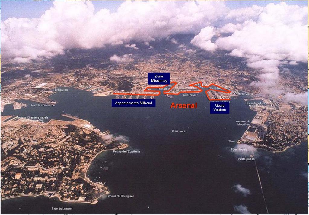
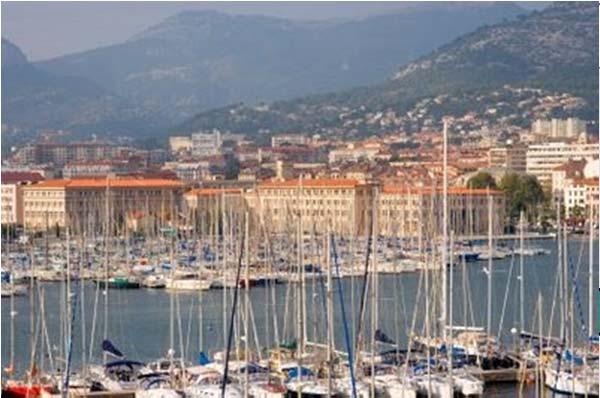
3 Situation First French military harbour

4 Radionuclide dispersion modelling Risk Radionuclide dispersion simulations Concentration maps Sensitivity Ecological and economical intrinsic value for homogeneous zones Vulnerability
5 Radionuclide dispersion modelling COUPLING Hydrodynamic sediment transport contaminant behaviour Source Term WATER COLUMN Dissolve + SM Partition coeff., T1/2 U, V, Temp, Sal MARS 3D Initial and boundary cond. Meteorological data Regional scale model MM5 Aladin (Meteo-France) Deposition Resuspension WAVES Bathymetric data SHOM data + Local records Bottom shear stress WW3 SWAN SEDIMENTS Mud - Sand Particulate settling velocity Grain size data Local measurements


6 Radionuclide dispersion modelling Implementation on Toulon area from Cap Sicié in the west to the Presqu île de Giens in the east. High spatial resolution 100m square meshes / 30 sigma vertical levels.


.")
7 Radionuclide dispersion modelling Meteorology météo OBC CDL West ouest CDL OBC East est Main forcing: wind (no tide) Meteorological data from Météo-France models CDL OBC South sud Nested models principle: Initial and Open boundary Conditions given by larger models (regional scale model 400m + northwest Mediterranean area model 1200m). MODELE LOCAL / Concentrations en Cs


8 Radionuclide dispersion modelling Two main wind directions : NW (mistral) and E - SE Surface current vectors and water temperature


9 Radionuclide dispersion modelling Wind Surface S N Bottom South North profile : current intensities Mid-depth current reversal
10 Radionuclide dispersion modelling Test : 1 GBq 137 Cs spill into harbour water simulated on 15 June 2009 Dissolve 137 Cs concentration (Bq.m -3 ) - log scale

11 Radionuclide dispersion modelling Test : 1 GBq 137 Cs spill into harbour water simulated on 15 June Cs in bottom sediments (Bq.m -3 ) - log scale
12 Sensitivity mapping Risk Radionuclide dispersion simulations Concentration maps Sensitivity Ecological and economical intrinsic value for homogeneous zones Vulnerability
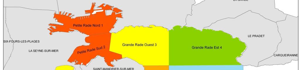
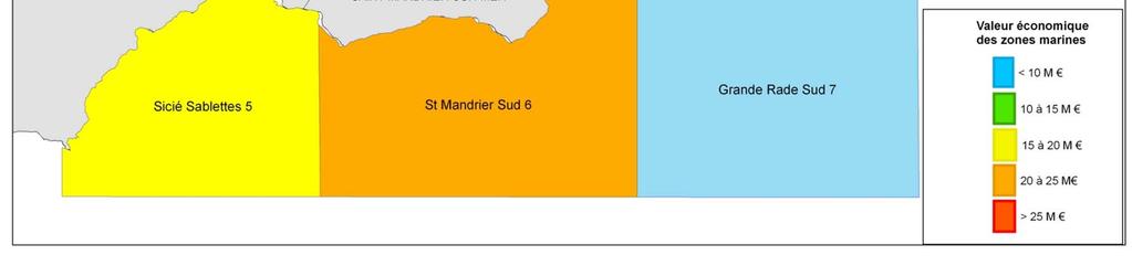
13 Sensitivity mapping 1/ to characterize defined coastal zones through their environmental and socio-economic aspects. 2/ to elaborate sensitivity maps to identify preferred zones.

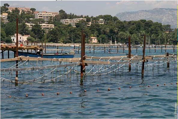
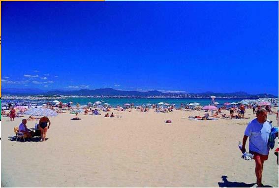
14 Sensitivity mapping 7 homogeneous areas (1) «ecological» aspects defined by remarkable benthic habitats (2) «socio-economic» aspects market activities: fisheries, aquaculture, lodging, restaurants, yachting, scuba diving, etc non market activities: beach going, recreational fishing, etc..


15 Sensitivity mapping Posidonia Oceanica sea grass beds Coralligène formations Ecological sensitivity
16 Sensitivity mapping Socio - Economical sensitivity (summer)


17 Sensitivity mapping Socio - Economical sensitivity (winter)
18 Conclusion Radionuclide dispersion simulation tool is now implemented in Toulon area - Different in-situ measurements are operated since 2009 for its validation. First modeling results suggest that in case of any accidental release occuring in the Little Bay, the dispersion of radionuclides would be very slow. The Little Bay and the western part of the Toulon Bay would be the most contaminated. Little Bay is of economical importance (more than 64 million euros of direct or indirect benefits). The western part of the studied area, from Cap Sicié to Saint-Mandrier peninsula, is the more ecologically sensitive. Looking at these results, these areas can be qualified as the most vulnerable in any accidental situation concerning the marine environment of Toulon.
Towards a decision support tool: sensitivity mapping of the French Mediterranean coastal environment (a case study of fishery and lodging)
") Environmental Economics and Investment Assessment III 135 Towards a decision support tool: sensitivity mapping of the French Mediterranean coastal environment (a case study of fishery and lodging) C. Scheurle,
Environmental Economics and Investment Assessment III 135 Towards a decision support tool: sensitivity mapping of the French Mediterranean coastal environment (a case study of fishery and lodging) C. Scheurle,
Environmental impact assessment study of the new offshore dumping sites for Šventoji port in Lithuania
 Environmental impact assessment study of the new offshore dumping sites for Šventoji port in Lithuania Introduction Summary In 2003 Lithuanian Ministry of Transport initiated the preparation of feasibility
Modelling the Channel and the Bay of Biscay using the MARS model. Contributions: Dyneco Physed / Pelagos / Benthos EMH
 Modelling the Channel and the Bay of Biscay using the MARS model Contributions: Dyneco Physed / Pelagos / Benthos EMH Overview 1. The MANGA Configuration 2. Model validation: Sea Surface Temperature 3.
of ecosystem around bay. Coral Reef as one of ecosystem in Bungus Bay has boundary condition to keep functional. One
 Study of Coral Reef Ecosystem Vulnerability using Sediment Transport Modeling in Bungus Bay, West Sumatera Ibnu Faizal 1, Nita Yuanita 2 1 Ocean Engineering Master Program, Faculty of Civil and Environmental
PTM: A Lagrangian Particle Tracking Model. Joseph Gailani
 PTM: A Lagrangian Particle Tracking Model Joseph Gailani Joe.Z.Gailani@usace.army.mil OUTLINE Motivation for sediment/constituent modeling system Objectives of modeling system Description of PTM PTM Example
The use of MIKE21 to study the. barrier beach system of Inner Dingle Bay, Co. Kerry, Ireland. Dr. Michael O Shea Malachy Walsh and Partners
 The use of MIKE21 to study the morphodynamic evolution of the mid-bay barrier beach system of Inner Dingle Bay, Co. Kerry, Ireland Dr. Michael O Shea Malachy Walsh and Partners Contents Why Study Morphodynamics
Jing Lu,Fangli Qiao,Yonggang Wang,Changshui Xia,Feng Shan
 Laboratory of Marine Science and Numerical Modeling (MASNUM) The First Institute of Oceanography (FIO),SOA, CHINA Jing Lu,Fangli Qiao,Yonggang Wang,Changshui Xia,Feng Shan Email: lujing@fio.org.cn Content
and applications Litto 3 D - GEBCO 09/29/09 Vincent DONATO
 Litto 3 D and applications Vincent DONATO Contents Litto3D project Applications : modeling sea-land interaction Simulating the tide Cadastral management Sea-rising risk management Continuous, high resolution
Contents. Preface. IC. Introductory Chapter. 1. The Ocean in the Earth System. Ocean Studies and Pedagogy Acknowledgments
 Contents Preface Ocean Studies and Pedagogy Acknowledgments IC. Introductory Chapter IC.1 Why the Ocean is Important to Us? IC.1.1 Biological Resources IC.1.1.1 Fisheries IC.1.1.2 Other Biological Resources
Coastal Vulnerability and Risk Parameters
 European Water 11/12: 3-7, 2005. 2005 E.W. Publications Coastal Vulnerability and Risk Parameters E. Doukakis National Technical University of Athens-Dept. of Rural and Surveying Engineering, Lab. of Higher
Restoration of a boulder reef in Kattegat a numerical study of the design parameters and impact on sediment transport
 Restoration of a boulder reef in Kattegat a numerical study of the design parameters and impact on sediment transport S. Niemann, K. Bundgaard, et. al. DHI Water Environment Health, Denmark Boulder reef
Behavior of radioactive cesium accumulation in water bodies in contaminated area by FDNPP accident
 Behavior of radioactive cesium accumulation in water bodies in contaminated area by FDNPP accident Seiji HAYASHI Center for Regional Environmental Research National Institute for Environmental Studies
Applying Gerris to Mixing and Sedimentation in Estuaries
 Applying Gerris to Mixing and Sedimentation in Estuaries Timothy R. Keen U.S. Naval Research Laboratory Stennis Space Center, Mississippi, U.S.A. 4 July 2011 Université Pierre et Marie Curie Paris, France
Marine environment monitoring : The basic requirements to support Marine Renewable Energies
 Marine environment monitoring : The basic requirements to support Marine Renewable Energies SHOM in brief SHOM is the French Government agency in charge of Hydrography and Oceanography SHOM s vocation
TASMANIAN SEAGRASS COMMUNITIES
 TASMANIAN SEAGRASS COMMUNITIES by Christopher Grant Rees, B.Ed (}Ions.) Submitted in partial fulfilment of the requirement for the degree of Master of Environmental Studies (By Coursework) Centre for Environmental
Climate change and socio-economic impact on the long term sediment balance in the Belgian Part of the North Sea
 Climate change and socio-economic impact on the long term sediment balance in the Belgian Part of the North Sea De Sutter Renaat, Ghent University & IMDC Van Lancker Vera, Fettweis Michael, Van den Eynde
Using the Mercator ocean forecasting system to compute coastal maritime pollution risk indicators on the Atlantic European coasts
 Environmental Problems in Coastal Regions VI 437 Using the Mercator ocean forecasting system to compute coastal maritime pollution risk indicators on the Atlantic European coasts S. Besnard 1, E. Dombrowsky
Climate change, ocean acidification and individual-based models: Why the little things matter
 Climate change, ocean acidification and individual-based models: Why the little things matter Author Richards, Russell, Meynecke, Olaf, Chaloupka, M, Tomlinson, Rodger Benson Published 2012 Conference
E x a m p l e s o f t o o l s f o r s e a s i t u a t i o n a l a w a r e n e s s u s i n g C M E M S d a t a. Copernicus EU
 E x a m p l e s o f t o o l s f o r s e a s i t u a t i o n a l a w a r e n e s s u s i n g C M E M S d a t a Copernicus EU Copernicus EU Copernicus EU www.copernicus.eu S e a S i t u a t i o n a l A w
heterogeneous vs homogeneous distribution of radionuclides in sediment regarding dose rate calculation
 heterogeneous vs homogeneous distribution of radionuclides in sediment regarding dose rate calculation EMRAS II BMG Vienna January 2011 K. Beaugelin-Seiller Summary of the previous episodes Context Sediments
WIND EFFECTS ON CHEMICAL SPILL IN ST ANDREW BAY SYSTEM
 WIND EFFECTS ON CHEMICAL SPILL IN ST ANDREW BAY SYSTEM PETER C. CHU, PATRICE PAULY Naval Postgraduate School, Monterey, CA93943 STEVEN D. HAEGER Naval Oceanographic Office, Stennis Space Center MATHEW
Characteristics of sediment distribution and influencing factors at the Lingshanwan bathing beach of Qingdao
 33 2 2014 4 MARINE SCIENCE BULLETIN Vol. 33,No. 2 Apr. 2014 Doi 10. 11840/j. issn. 1001-6392. 2014. 02. 006 1 2 3 4 1 1 1 1 1. 2665802. 3. 2660714. 257061 266061 - P736.21 P76 A 1001-69322014 02-0157-06
The Portuguese Forecasting System. Instituto Superior Técnico Lisbon Portugal. Guillaume Riflet, POL workshop, 22nd 24th October, Mallorca
 The Portuguese Forecasting System Instituto Superior Técnico Lisbon Portugal Guillaume Riflet, POL workshop, 22nd 24th October, Mallorca Contents The portuguese in the ECOOP framework Observation system
Dunes Growth Estimation for Coastal Protection
 Dunes Growth Estimation for Coastal Protection Muhammad Zikra Department of Ocean Engineering, Faculty of Marine Technology, ITS, Kampus ITS Keputih Sukolilo, Surabaya 60111 Abstract: This paper describes
Temporal variability of partially-contaminated sediments in a strongly regulated reservoir of the upper Rhine River
 Temporal variability of partially-contaminated sediments in a strongly regulated reservoir of the upper Rhine River Germain Antoine 1,2,, Thomas Pretet 1,3,, Matthieu Secher 3,, and Anne Clutier 3, 1 Laboratoire
Modeling of Dredging-Induced Sediment Resuspension: Remaining Questions and Progress Toward Answers
 Modeling of Dredging-Induced Sediment Resuspension: Remaining Questions and Progress Toward Answers Thomas Borrowman Douglas Clarke Tahirih Lackey US Army Corps of Engineers Research and Development Center,
Predicting the Fate of Sediment Suspended Due to Dredging and Placement
 Predicting the Fate of Sediment Suspended Due to Dredging and Placement Tahirih Lackey and Thomas Borrowman US Army ERDC, Vicksburg, MS Tahirih.C.Lackey@erdc.usace.army.mil Thomas.D.Borrowman@erdc.usace.army.mil
Validation of KPP in a coastal area
 Validation of KPP in a coastal area By (Météo France/SHOM) and Rémy Baraille (SHOM), Yves Morel (SHOM), Gwenaëlle Hello (Météo France), Hervé Giordani (Météo France) Contents I. Data from MOUTON2007; II.
SW Florida Escarpment Mapping Area
 Overview NOAA s Okeanos Explorer (EX) Program plans to conduct systematic mapping and telepresence-enabled ROV explorations in the Gulf of Mexico during Spring 2014. In 2011, the EX conducted mapping operations
Sediment management: a european perspective. Piet den Besten Centre for Water Management Rijkswaterstaat, Netherlands
 Sediment management: a european perspective Piet den Besten Centre for Water Management Rijkswaterstaat, Netherlands Content Background of Dutch-German exchange (DGE plus) What is needed for adequate sediment
Overview of HYCOM activities at SHOM
 Overview of HYCOM activities at SHOM Stéphanie Louazel, Stéphanie Corréard, Rémy Baraille, Annick Pichon, Cyril Lathuilière, Audrey Pasquet, Emeric Baquet LOM2015 Copenhagen 2 nd 4 th June 2015 French
Sand and Oil Agglomerates in the Surf Zone Using Science to Aid Deepwater Horizon Clean-up Efforts
 Sand and Oil Agglomerates in the Surf Zone Using Science to Aid Deepwater Horizon Clean-up Efforts P. Soupy Dalyander St. Petersburg Coastal and Marine Science Center DOI USGS Sand and Oil Agglomerates
NAME: GEL 109 Final Winter 2010
 GEL 109 Final Winter 2010 1. The following stratigraphic sections represents a single event followed by the slow accumulation of background sedimentation of shale. Describe the flows that produced the
High Resolution Numerical Models of Tidal Marshes in the Delaware Bay
 High Resolution Numerical Models of Tidal Marshes in the Delaware Bay Ramona Stammermann Dept. of Civil, Architectural & Environmental Engineering, Drexel University, Philadelphia, PA Michael Piasecki
Major human activities affecting Norwegian coastal marine ecosystems; present status and challenges
 Major human activities affecting Norwegian coastal marine ecosystems; present status and challenges Erlend Moksness PICES Annual Meeting - Science Board Symposium 26. October 2009, Jeju, Korea FUTURE:
Opening their Shells Getting commercial clammers involved in marine spatial planning
 Opening their Shells Getting commercial clammers involved in marine spatial planning Ed Lewandowski Coastal Communities Development Specialist University of Delaware/Delaware Sea Grant Highlights Background
Aquaculture Spatial Planning: The case of Greece
 Aquaculture Spatial Planning: The case of Greece Nikos Anagnopoulos Panhellenic Association for Small-Medium sized Aquaculture Enterprises Panhellenic Association for Small-Medium sized Aquaculture Enterprises
Marine/Maritime Spatial Planning Andrej Abramić
 Marine/Maritime Spatial Planning Andrej Abramić EcoAqua SUMMER SCHOOL: Ecosystem approach to aquaculture 26-29th of October 2015 Research and Technology to enhance excellence in Aquaculture development
Marine Spatial Planning: A Tool for Implementing Ecosystem-Based Management
 Marine Spatial Planning: A Tool for Implementing Ecosystem-Based Management Steven Murawski, Ph.D., Ecosystem Goal Team Lead National Oceanic and Atmospheric Administration NOAA November 16, 2009 1 To
Liana Talaue McManus. Division of Marine Affairs and Policy Rosenstiel School of Marine & Atmospheric Science University of Miami
 Liana Talaue McManus Division of Marine Affairs and Policy Rosenstiel School of Marine & Atmospheric Science University of Miami Outline 1. Coasts as vulnerable & resilient social ecological systems 2.
Exploring the impacts of future global change on mangrove-fishery-community linkages
 Exploring the impacts of future global change on mangrove-fishery-community linkages Rachel Seary University of Cambridge/ UNEP-WCMC Supervisors: Dr Tom Spencer, Dr Mike Bithell & Dr Chris McOwen Photograph:
Coastal Barrier Island Network (CBIN): Management strategies for the future
: Management strategies for the future") Coastal Barrier Island Network (CBIN): Management strategies for the future Heather Joesting*, Amy Williams**, Rusty Feagin**, and William K. Smith* *Department of Biology, Wake Forest University, Winston
Coastal Barrier Island Network (CBIN): Management strategies for the future Heather Joesting*, Amy Williams**, Rusty Feagin**, and William K. Smith* *Department of Biology, Wake Forest University, Winston
Quantifying effects of oil on coastal dune vegetation. Thomas Miller and Elise Gornish Biological Science, Florida State University
 Quantifying effects of oil on coastal dune vegetation Thomas Miller and Elise Gornish Biological Science, Florida State University Natural History of Barrier Islands in the Northern Gulf Make up ~70% of
Observing the Ocean:
 Observing the Ocean: A changing Paradigm A vision for Operational Oceanography James Baker* - Jean-François Minster ** * Chair Goos Committee,, Président CEO Academy of Natural Sciences Philadelphie **
Application and verification of the ECMWF products Report 2007
 Application and verification of the ECMWF products Report 2007 National Meteorological Administration Romania 1. Summary of major highlights The medium range forecast activity within the National Meteorological
Significant Ecological Marine Area Assessment Sheet
 Significant Ecological arine Area Assessment Sheet Name: Eastern Bay of Island Biogenic Soft Sediment Complex Summary: The semi-sheltered areas between the central islands of the Eastern Bay of Islands
Welsh Assembly Debate on the proposal to dump 300,000 tonnes of radioactively contaminated sediment into the Cardiff Grounds marine dispersal site
 Welsh Assembly Debate on the proposal to dump 300,000 tonnes of radioactively contaminated sediment into the Cardiff Grounds marine dispersal site As Assembly Members, you have to make a decision which
12.0 COASTAL PROCESSES
 12.0 COASTAL PROCESSES 12.1 Introduction This Chapter of the EIS considers the potential and likely significant effects of the proposed alterations to the permitted development. The purpose of this chapter
The assessment of sediment bed properties within the York River estuary as a function of spring and neap tidal cycles
 The assessment of sediment bed properties within the York River estuary as a function of spring and neap tidal cycles Lindsey Kraatz and Carl Friedrichs York River Research Symposium April 20, 2011 Motivation
DRIVEN LARVAL TRANSPORT ON SALEH BAY, SUMBAWA, INDONESIA *)
") BAROTROPIC TIDAL AND WIND-DRIVEN DRIVEN LARVAL TRANSPORT ON SALEH BAY, SUMBAWA, INDONESIA *) Widodo S. Pranowo 1), Yulia Herdiani 2) Ivonne M. Radjawane 3) 2), *) Presenting on WOM-12 APEC/MRC/OMISAR in
BAROTROPIC TIDAL AND WIND-DRIVEN DRIVEN LARVAL TRANSPORT ON SALEH BAY, SUMBAWA, INDONESIA *) Widodo S. Pranowo 1), Yulia Herdiani 2) Ivonne M. Radjawane 3) 2), *) Presenting on WOM-12 APEC/MRC/OMISAR in
nuclear science and technology
 EUROPEAN COMMISSION nuclear science and technology Processes Regulating Remobilisation, Bioavailability, and Translocation of Radionuclides in Marine Sediments (REMOTRANS) Contract No: FIGE-CT-2000-00085
Habitat Suitability for Forage Fishes in Chesapeake Bay
 Habitat Suitability for Forage Fishes in Chesapeake Bay Aug 2017 Jul 2019 Mary C Fabrizio Troy D Tuckey Aaron J Bever Michael L MacWilliams 21 June 2018 Photo: Chesapeake Bay Program Motivation Production
INTEGRATED COASTAL SEDIMENT MANAGEMENT AT PHYSIOGRAPHIC UNIT SCALE, AN APPLICATION IN VERSILIA LITTORAL (TUSCANY, ITALY)
") INTEGRATED COASTAL SEDIMENT MANAGEMENT AT PHYSIOGRAPHIC UNIT SCALE, AN APPLICATION IN VERSILIA LITTORAL (TUSCANY, ITALY) Damiano Scarcella (Msc) Sergio Cappucci (PhD) Andrea Taramelli (PhD) OUTLINE Sediment
INTEGRATED COASTAL SEDIMENT MANAGEMENT AT PHYSIOGRAPHIC UNIT SCALE, AN APPLICATION IN VERSILIA LITTORAL (TUSCANY, ITALY) Damiano Scarcella (Msc) Sergio Cappucci (PhD) Andrea Taramelli (PhD) OUTLINE Sediment
Larvae. Juvenile. Adult. Bipartite life cycle of benthic marine fishes with pelagic larvae. Pelagic Environment. settlement.
 13 - Marine Ecology Bipartite life cycle of benthic marine fishes with pelagic larvae Larvae survive, grow, develop, disperse reproduce Pelagic Environment Benthic Environment settlement Adult Juvenile
Chapter 2 Planet Earth
 Chapter 2 Planet Earth Section Notes Earth and the Sun s Energy Water on Earth The Land Close-up The Water Cycle World Almanac Major Eruptions in the Ring of Fire Quick Facts Chapter 2 Visual Summary Video
HUMAN INTERVENTIONS AND ALTERATIONS OF THE GEOMORPHOLOGICAL CHARACTERISTICS IN PARTS OF THE COASTAL AREA IN THE IONIAN COAST (IPIROS - GREECE)
") HUMAN INTERVENTIONS AND ALTERATIONS OF THE GEOMORPHOLOGICAL CHARACTERISTICS IN PARTS OF THE COASTAL AREA IN THE IONIAN COAST (IPIROS - GREECE) Α. Mertzanis (1), F. Marabini (2), A. Galvani (3), S. Castelli
HUMAN INTERVENTIONS AND ALTERATIONS OF THE GEOMORPHOLOGICAL CHARACTERISTICS IN PARTS OF THE COASTAL AREA IN THE IONIAN COAST (IPIROS - GREECE) Α. Mertzanis (1), F. Marabini (2), A. Galvani (3), S. Castelli
CURRENT ACTIVITY IN THE THERMAIKOS GULF CONTINENTAL MARGIN, IN RELATION TO MODERN SEDIMENTATION PROCESSES
 ελτίο της Ελληνικής Γεωλογικής Εταιρίας τοµ. XXXVI, 2004 Πρακτικά 10 ου ιεθνούς Συνεδρίου, Θεσ/νίκη Απρίλιος 2004 Bulletin of the Geological Society of Greece vol. XXXVI, 2004 Proceedings of the 10 th
Reexamining the Relationship of Beryllium-7 Adsorption to Grain Size in the York River, Virginia
 Reexamining the Relationship of Beryllium-7 Adsorption to Grain Size in the York River, Virginia A thesis submitted in partial fulfillment of the requirements for the degree of Bachelor of Science in Geology
Possible causes of sediment dynamics and mixing in western Baltic Sea basins
 Tauber, F. (2012), BSH, BSBD Possible causes of sediment dynamics and mixing in western Baltic Sea basins Dennis Bunke Thomas Leipe, Matthias Moros & Helge W. Arz dennis.bunke@io-warnemuende.de Tauber,
Modeling habitat suitability for the European green crab using the ShoreZone mapping system
 Modeling habitat suitability for the European green crab using the ShoreZone mapping system Jodi N. Harney, Ph.D. and John R. Harper, Ph.D. Coastal and Ocean Resources Inc. Mary Morris, R.P. Bio. Archipelago
TOSCA RESULTS OVERVIEW
 TOSCA RESULTS OVERVIEW Almost 3 years after the project started, TOSCA has proved capable of improving oil spill tracking systems. TOSCA has brought updated knowledge on surface currents and noticeable
WHAT IS THE EARTH MADE OF? LITHOSPHERE AND HYDROSPHERE
 UNIT 8 WHAT IS THE EARTH MADE OF? LITHOSPHERE AND HYDROSPHERE TABLE OF CONTENTS 1 THE STRUCTURE OF THE EARTH... 2 2 THE FORMATION OF THE RELIEF: INTERNAL AND EXTERNAL FORCES.... 2 2.1 Internal forces:
USING METEOROLOGICAL ENSEMBLES FOR ATMOSPHERIC DISPERSION MODELLING OF THE FUKUSHIMA NUCLEAR ACCIDENT
 USING METEOROLOGICAL ENSEMBLES FOR ATMOSPHERIC DISPERSION MODELLING OF THE FUKUSHIMA NUCLEAR ACCIDENT 17th International Conference on Harmonisation within Atmospheric Dispersion Modelling for Regulatory
Risks to Estuarine Biota under Proposed Development in the Whitford Catchment Summary Report
 Risks to Estuarine Biota under Proposed Development in the Whitford Catchment Summary Report August 2003 TP204 Auckland Regional Council Technical Publication No. 204, 2003 ISSN 1175-205X ISBN -1-877353051
Sediment Connectivity and Exchange in Ameland Inlet
 Sediment Connectivity and Exchange in Ameland Inlet Stuart G. Pearson, Bram C. van Prooijen, Zheng Bing Wang, and Jasper P. Bak January 11 th, 2017 NCK Symposium on Sediment Sorting Study Site: Ameland
Hurricane IRMA Shom s actions & lessons learned
 Hurricane IRMA Shom s actions & lessons learned MACHC 18 Varadero, Cuba 30.11.17 TIDE OBSERVATION FRENCH PERMANENT SEA LEVEL OBSERVATION NETWORK IN THE CARIBBEAN S t Martin Deshaies La Désirade Point à
June 2018 Sediments and Dredging at GBR Ports
 June 2018 Sediments and Dredging at GBR Ports Reef 2050 Long Term Sustainability Plan The Great Barrier Reef is over 2000 km long and covers an area of approximately 350,000 square kilometres. It is a
ROMS Modelling in Australia: current status, plans and aspirations:
 ROMS Modelling in Australia: current status, plans and aspirations: John F Middleton, Moninya Roughan, Chari Pattiaratchi, Greg Ivey, Ryan Lowe, Jessica Benthuysen. and teams : John Luick, Charles James,
Aquatic Transfer Facility (ATF) San Pablo Bay (SPB) Proposed Region of ATF. Proposed Seabed Pipeline
 San Pablo Bay (SPB) Proposed Region of ATF. Proposed Seabed Pipeline") Aquatic Transfer Facility (ATF) San Pablo Bay (SPB) Proposed Region of ATF Proposed Seabed Pipeline Technical Studies An Overview Scope: Provide background and new scientific information and analysis for
Aquatic Transfer Facility (ATF) San Pablo Bay (SPB) Proposed Region of ATF Proposed Seabed Pipeline Technical Studies An Overview Scope: Provide background and new scientific information and analysis for
Seasonal forecasting as a stepping stone to climate adaptation in marine fisheries and aquaculture
 Seasonal forecasting as a stepping stone to climate adaptation in marine fisheries and aquaculture Alistair Hobday Paige Eveson Jason Hartog Claire Spillman Projected changes (e.g. distribution) 11 species
Seabed knowledge In support of UN SDGs
 Seabed knowledge In support of UN SDGs Evert Flier Fiskerifaglig forum 2. november 2017 Hydrography & small scale fishing Hydrography in Transition Serving the Maritime Community Hydrography in Transition
TOWARDS CLIMATE-RESILIENT COASTAL MANAGEMENT: OPPORTUNITIES FOR IMPROVED ICZM IN BELIZE
 TOWARDS CLIMATE-RESILIENT COASTAL MANAGEMENT: OPPORTUNITIES FOR IMPROVED ICZM IN BELIZE CHANTALLE SAMUELS Coastal Zone Management Authority and Institute The Caribbean Community Climate Change Centre VULNERABILITY
New developments in data assimilation in MIKE 21/3 FM Assimilation of along-track altimetry data with correlated measurement errors
 New developments in data assimilation in MIKE 21/3 FM Assimilation of along-track altimetry data with correlated measurement errors EnKF Workshop 2016-06-20 Jesper Sandvig Mariegaard Henrik Andersson DHI
NOAA s OCM: Services, tools and collaboration opportunities & Puerto Rico s NE Marine Corridor as a case study
 NOAA s OCM: Services, tools and collaboration opportunities & Puerto Rico s NE Marine Corridor as a case study Dr. Antares Ramos Álvarez NOAA s Office of Coastal Management September 15 th, 2016 Conservation
Economic Valuation of the Montego Bay Marine Park
 Economic Valuation of the Montego Bay Marine Park Methodology Test Cases Presenter: Brian L. Zane What? A means to estimate the value of environmental resources How? Different methodologies exist Total
The known requirements for Arctic climate services
 The known requirements for Arctic climate services based on findings described in STT White paper 8/2015 Johanna Ekman / EC PHORS STT Regional drivers The Arctic region is home to almost four million people
Suspension sorting at the Sand Motor NCK theme day
 Suspension sorting at the Sand Motor NCK theme day B.J.A. Huisman oct 2010 may 2011 oct 2013 feb 2014 1 Context PhD research Where do the sand grains go? Bed composition changes Case : Sand Motor Big disturbance!
Climate Change Impacts, Adaptation and Vulnerability: Small Islands - South West Pacific
 Climate Change Impacts, Adaptation and Vulnerability: Small Islands - South West Pacific Penehuro F. Lefale Lead Author (LA), Chapter 16 Manager, International Cooperation & Development NZ Meteorological
Del Mar Sediment Management Study
 Del Mar Sediment Management Study Shoreline Preservation Working Group, June 7, 2018 Lindsey Sheehan Current work in Del Mar 2016 Sea-Level Rise Vulnerability Assessment 2018 Adaptation Plan 2018 Sediment
Sediments in a changing Environment Ecological implications of dredging and relocation in the Elbe estuary Günther Eichweber, WSD-Nord
 Sediments in a changing Environment Ecological implications of dredging and relocation in the Elbe estuary Günther Eichweber, WSD-Nord 2011-04-07 S1 Basic problem: sediment budget out of equilibrium 2011-04-07
Fukushima nuclear power plant damaged by M9 Earthquake with some focus on ocean
 Fukushima nuclear power plant damaged by M9 Earthquake with some focus on ocean Moto Ikeda (Hokkaido Univ. & JAMSTEC) Oceanographic Society of Japan, Earthquake Disaster Working Group Magnitude-9 earthquake
BEFORE THE ENVIRONMENTAL PROTECTION AUTHORITY AT WELLINGTON
 BEFORE THE ENVIRONMENTAL PROTECTION AUTHORITY AT WELLINGTON IN THE MATTER of the Exclusive Economic Zone and Continental Shelf (Environmental Effects) Act 2012 (EEZ Act) AND IN THE MATTER BETWEEN AND AND
Computer Model of Water Clarity in Shallow Water for Chesapeake Bay Water Quality Management
 Computer Model of Water Clarity in Shallow Water for Chesapeake Bay Water Quality Management P. Wang 1 and L.C. Linker 2 1 UMCES/CBPO, 2 USEPA/CBPO CERF 09 - Portland, OR November 4, 2009 USA Chesapeake
Sediment Traps. CAG Meeting May 21, 2012
 Sediment Traps CAG Meeting May 21, 2012 Agenda Background Fundamentals of Sediment Transport Sediment Trap Existing Information Next Steps 2 The Site Saginaw River 22 mile river beginning at confluence
A process-based approach toward assessing the coastal impact of projected sea level rise and severe storms
 A process-based approach toward assessing the coastal impact of projected sea level rise and severe storms Patrick Barnard 1, Cheryl Hapke 2, Li Erikson 1, Amy Foxgrover 1, and Maarten van Ormondt 3 1
Sediment and Sedimentary rock
 Sediment and Sedimentary rock Sediment: An accumulation of loose mineral grains, such as boulders, pebbles, sand, silt or mud, which are not cemented together. Mechanical and chemical weathering produces
Introduction to IMP: need and added value
 Introduction to IMP: need and added value Christophe Le Visage Consultant Stratégies Mer et Littoral 1 Summary IMP : Why? The case for integration 1 What is IMP? 2 Content, process IMP: Added Value 3 2
Combining multi source data to estimate a suspended sediment budget for a Mediterranean deltaic hydro-system (Rhone delta, France).
.") Combining multi source data to estimate a suspended sediment budget for a Mediterranean deltaic hydro-system (Rhone delta, France). Chauvelon 1,P., Boutron 1, O., Loubet 1,2, A., M. Pichaud 1, and P. Höhener
Combining multi source data to estimate a suspended sediment budget for a Mediterranean deltaic hydro-system (Rhone delta, France). Chauvelon 1,P., Boutron 1, O., Loubet 1,2, A., M. Pichaud 1, and P. Höhener
HF radarcontribution to South Africa Blue Economy
 HF radarcontribution to South Africa Blue Economy Anton G Kjelaas1, Andres Alonso- Martirena2, Chad Whelan3 South Africa- Norway Science Week 2016 Oct 31- Nov 4 2016 1 2 3 BLUE ECONOMY Sustainable use
Research Topic Updated on Oct. 9, 2014
 Research Topic Updated on Oct. 9, 204 Mixed Cohesive/Non-cohesive Sediments Sedimentation in Estuary: Flocculation Deposition Erosion Transport Consolidation *: It has been recognized that when the fraction
Scenarios for the NI coast in the 21 st Century
 Scenarios for the NI coast in the 21 st Century Prof Julian Orford Geography, Archaeology & Palaeoecology Queen s University, Belfast Challenging perspective Living by the coast is good for your health!
Sediment Stability in the Lower Passaic River Integration of Multiple Lines of Evidence
 Sediment Stability in the Lower Passaic River Integration of Multiple Lines of Evidence Fourth Passaic River Symposium June 22, 21 Michael Barbara, mab.consulting, LLC Marcia Greenblatt, AECOM John Connolly,
Appendix G.18 Hatch Report Pacific NorthWest LNG Lelu Island LNG Potential Impacts of the Marine Structures on the Hydrodynamics and Sedimentation
 Appendix G.18 Hatch Report Pacific NorthWest LNG Lelu Island LNG Potential Impacts of the Marine Structures on the Hydrodynamics and Sedimentation Patterns Project Memo H345670 To: Capt. David Kyle From:
Sediment Management for Dam Removals
 Sediment Management for Dam Removals As Presented To: Sediment Management for Dam Removals, A Hands on Workshop on the Latest Techniques for Dam Modification and Removal, Purdue University Calumet, IN,
Beach Recovery Processes in Urban Beach Systems : A Study in Hong Kong after an Extreme Storm Event
 Beach Recovery Processes in Urban Beach Systems : A Study in Hong Kong after an Extreme Storm Event LIFE+ FLANDRE international workshop "Management of coastal dunes and sandy beaches" Session 1. Climate
1. Oceans. Example 2. oxygen.
 1. Oceans a) Basic facts: There are five oceans on earth, making up about 72% of the planet s surface and holding 97% of the hydrosphere. Oceans supply the planet with most of its oxygen, play a vital
SEDIMENT TRANSPORT AND GO-CONG MORPHOLOGICAL CHANGE MODELING BY TELEMAC MODEL SUITE
 SEDIMENT TRANSPORT AND GO-CONG MORPHOLOGICAL CHANGE MODELING BY TELEMAC MODEL SUITE TABLE OF CONTENTS 1. INTRODUCTION... 2 2. OBJECTIVES... 2 3. METHOLOGY... 2 4. MODEL CALIBRATION, VALIDATION OF SEDIMENT
Using seascapes to help predict Australia s benthic marine habitat diversity in the development of a national system of marine protected areas
 Using seascapes to help predict Australia s benthic marine habitat diversity in the development of a national system of marine protected areas A.D. Heap 1, T. Whiteway 1, V. Lucieer 2, S. Nichol 1 1. Geoscience
Coastal Inundation Forecasting Demonstration Project CIFDP. Flood Forecasting Initiative-Advisory Group (FFI-AG 3), Geneva, 5-7 Dec, 2017
, Geneva, 5-7 Dec, 2017") Coastal Inundation Forecasting Demonstration Project CIFDP Flood Forecasting Initiative-Advisory Group (FFI-AG 3), Geneva, 5-7 Dec, 2017 Coastal Flooding & Vulnerable Populations Coastal populations are
Coastal Inundation Forecasting Demonstration Project CIFDP Flood Forecasting Initiative-Advisory Group (FFI-AG 3), Geneva, 5-7 Dec, 2017 Coastal Flooding & Vulnerable Populations Coastal populations are