From seafloor geomorphology to predictive habitat mapping: progress in applications of biophysical data to ocean management.
|
|
|
- Duane Berry
- 5 years ago
- Views:
Transcription

1 From seafloor geomorphology to predictive habitat mapping: progress in applications of biophysical data to ocean management. Peter T. Harris Geoscience Australia, Canberra ACT, Australia Currently seconded to: UNEP/GRID Arendal, Norway

2 Acknowledgements Thanks to Thaiënne van Dijk and conference organisers for invitation to attend Hydro12 Geoscience Australia travel support Research products of Geoscience Australia and many other scientists/institutions involved
3 Uses of hydrographic data: Safe Navigation (nautical charts) Offshore oil and gas exploration and development Fisheries management Offshore minerals and aggregates Determining national marine jurisdiction (ECS) Port development and maintenance Computer models of tides, waves, ocean currents Communication (Google Oceans) Naval operations Marine zone management
4 Outline of talk: Introduction - Spatial Marine Management Approaches to seafloor characterisation and applications to decision-making Geomorphic features Unsupervised seascapes classification Supervised predictive habitat models Conclusions
5 Spatial marine management Flaws of the sector-based approach Fishing, oil and gas, shipping etc. managed separately Inconsistent with broader goals of biodiversity and ecosystem conservation Ecosystem based management (EBM) Addresses multiple pressures Acknowledges ecosystem services How to apply EBM? Need a spatial frame of reference (bioregions, ecosystem components, inventory of assets).
6 Mapping approaches that help to define bioregions and habitats: Seafloor geomorphic features Multivariate seascapes Predictive habitat modelling
 Predictive habitat maps supervised classifications (maximum entropy, decision-trees, etc.")
7 Approaches to seafloor characterisation: Approach How generated? Advantages Disadvantages Geomorphic features Biophysical interpolations unsupervised classifications (eg. seascapes) Predictive habitat maps supervised classifications (maximum entropy, decision-trees, etc.) interpreted from bathymetric data apply classification scheme multivariate analysis to spatially combine several biophysical data layers include direct observations of marine life with biophysical data to predict the potential distribution of species and benthic communities. + simple to communicate, technically easy to generate - limited predictive power + simple to generate with spatial data - limited predictive power, difficult to communicate + good predictive power, performance indicators - Difficult to generate (data hungry), relate to single species or group
8 Applications to decision-making (Australia case study) 1. Geomorphic features used to define Australian marine bioregions


9 Geomorphic features (IHO classes) mapped based on 250 m bathymetric grid of Australia Heap and Harris (2008) Australian Journal of Earth Sciences, 55:

10 Heap and Harris (2008) Geomorphic features map of Australia
11 The correlation between geomorphic features and benthic habitats is the focus of recent GeoHab book:

12 Marine management based on IMCRA provincial bioregions Many boundaries based on geomorphology IMCRA = Integrated Marine and Coastal Regionalisation of Australia
13 Heap and Harris (2008) Biophysical model - Geomorphology

14 Example of application of geomorphic features to assessment of industrial use Petroleum titles cover an area of about 620,000 km 2 or about 8.7% of Australia s EEZ (excluding offshore territories)
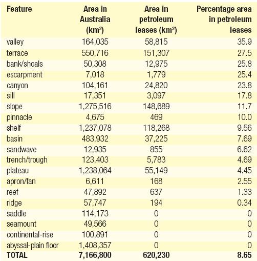
15
 APPEA Journal,")
16 Harris et al. (2007) APPEA Journal, 48:
17 Applications to decision-making (Australia case study) 2. Seascapes used to identify biodiversity hotspots and priorities for Marine Protected Areas
 = (e.g., tidal currents) + (e.g., bathymetry) + (e.g., slope) + (e.g., % sand)")
18 Integration of ecologically-significant biophysical variables to create a single map (Seascapes) Not scale dependant Integrated product Input physical data (Seascapes) = (e.g., tidal currents) + (e.g., bathymetry) + (e.g., slope) + (e.g., % sand)
19 Seven variables derived from interpolation of bathymetry, samples & modelled data Water Depth Slope %Gravel %Mud Effective Disturbance Seafloor Temperature Primary Productivity Completed using ERMapper ISOClass facility (Iterative Self Organising Classification)

20 Depth Slope %Gravel Grid resolution %Mud 0.01 o, ~5 km Seafloor Effective Primary Grid resolution Temperature 0.01 Productivity Disturbance o, ~5 km Grid resolution 0.01 o, ~5 km Grid resolution 0.01 o, ~5 km Grid Grid resolution o, ~5 o ~5 km km Grid resolution 0.01 o, ~5 km

21 Australia Shelf Seascapes 13 Ecologically unique Seascapes (Unsupervised Classification) 1. Moderate depth, flat, slightly gravelly, cold, low disturbance, moderate primary productivity

22 How relevant to Biodiversity? Seascape heterogeneity based on Focal Variety Analysis Used to identify hotspots of seascape heterogeneity (surrogate for biodiversity) 20 x 20 cell analysis area
 Ocean Coastal Management, 51:701-711.")
23 Australian Shelf Seascapes - Heterogeneity Harris et al. (2008) Ocean Coastal Management, 51:

24 SEWPaC Proposal June 2012, 60 reserves covering 3.1 million square kilometres, largest system of marine reserves in the world. Some MPAs suggested by seascape analysis, others by geomorphology
25 Applications to decision-making (Australia case study) 3. Predictive habitat model of coral habitat distribution in the Great Barrier Reef to assess marine park management scheme

26 Physical measurements: - Depth - Slope - Temperature - Sediment size - Current speed - etc. + = Biological observations Predicted habitat for species or community
27 Predictive Habitat Modeling Techniques (Huang et al., Ecological Informatics, 2011) BIOCLIMatic (BIOCLIM) (Nix, 1986) DOMAIN (Carpenter et al., 1993) Logistic Regression (LoR) (Peeters and Gardeniers, 1998; Ozesmi and Ozesmi, 1999; Felicisimo et al., 2002) Decision Trees (DT) (Zacharias et al., 1999; Pitcher et al., 2007) Genetic Algorithm for Rule-set Production (GARP) (Stockwell and Peters, 1999) Ecological Niche Factor Analysis (ENFA) (Hirzel et al., 2002) Generalised Additive Model (GAM) (Zaniewski et al., 2002) Artificial Neural Networks (ANN) (Joy and Death, 2004) Generalised Linear Model (GLM) (Brotons et al., 2004; Hirzel et al., 2006) Multivariate Adaptive Regression Spline (MARS) (Leathwick et al., 2005) Maximum Entropy (MAXENT) (Phillips et al., 2006) Support Vector Machine (SVM) (Drake et al., 2006; Guo et al., 2005,) Generalised Dissimilar Model (GDM) (Ferrier et al., 2007) Limiting Variable and Environmental Suitability (LIVES) (Li and Hilbert, 2008)


28 Maps of reef distribution based on satellite images and air photographs
 Some reefs were unable to keep pace")
29 Reef geology Most Holocene reefs in the GBR have Pleistocene reef limestone foundations. = BANK Most reefs are multi-generation limestone geomorphic banks (but not all banks support reefs) Some reefs were unable to keep pace with post-glacial sea level rise (submerged reefs)

30 Used new 100 m bathymetry grid (Beaman, 2010) - data contoured at 5 m

31 Digitising geomorphic banks: Banks exceed 15 m in elevation and have at least one steep side Digitised by hand NSS coral reef Example from 11 o S

32 Statistics of geomorphic banks in the GBR: Overall mean depth of banks = 27.3 m Total area of all bank types (less NSS reefs) = 25,599 km 2

33 How much of the 25,599 km 2 of bank area actually supports living coral communities? Use small, high-resolution data set to predict area of potential coral habitat Hydrographer s Passage
 5 m resolution 70% data used as training set Coral coverage on")
34 Occurrence records derived from optical images taken by autonomous underwater vehicle, together with: Area of deep coral habitat estimated using Maximum Entropy (MaxEnt) on a data set from Hydrographer s Passage - depth - slope - aspect - rugosity - acoustic backscatter -geomorphic zone (slope, crest, flat or depression) 5 m resolution 70% data used as training set Coral coverage on nine banks = 55 +/- 23%.
35 Interpretation: /- 23% of all banks = 14,000 +/ km 2 deep water coral communities. 2. NSS coral reefs area = 20,679 km 2 3. Therefore the area of coral habitat in the GBR is at least 50% larger and perhaps double the size previously believed to exist. 1 2

36 Protection of banks (deep reefs): Not protected from trawling ZONE TYPE Area (km 2 ) of banks included Number of banks included* Percent of banks by area Preservation Zone Marine National Park Zone 7, Conservation Park Zone Habitat Protection Zone 12, General Use Zone 3, Banks beyond GBR Marine Park 1, *Parts of banks may occur in more than one zone. Harris et al. (in press) ICES Journal of Marine Science
37 Concluding remarks
38 Concluding remarks Bathymetry underpins all seafloor characterisation maps Geomorphic features and seascapes useful for government decision-making and management Predictive habitat modelling the future GeoHab 2013 will be held in Rome, Italy (6-10 May)

39 Thank You!
Using seascapes to help predict Australia s benthic marine habitat diversity in the development of a national system of marine protected areas
 Using seascapes to help predict Australia s benthic marine habitat diversity in the development of a national system of marine protected areas A.D. Heap 1, T. Whiteway 1, V. Lucieer 2, S. Nichol 1 1. Geoscience
Seabed knowledge In support of UN SDGs
 Seabed knowledge In support of UN SDGs Evert Flier Fiskerifaglig forum 2. november 2017 Hydrography & small scale fishing Hydrography in Transition Serving the Maritime Community Hydrography in Transition
e-atlas Metadata Template
 e-atlas Metadata Template The template provided below is a summary of the key information required by the e-atlas inorder for the ISO19115 MCP standard records to be created. To create a new meta-data
June 2018 Sediments and Dredging at GBR Ports
 June 2018 Sediments and Dredging at GBR Ports Reef 2050 Long Term Sustainability Plan The Great Barrier Reef is over 2000 km long and covers an area of approximately 350,000 square kilometres. It is a
Outline. - Background of coastal and marine conservation - Species distribution modeling (SDM) - Reserve selection analysis. - Results & discussion
 - Reserve selection analysis. - Results & discussion") Application of GIS for data preparation and modeling for coastal and marine conservation planning in Madagascar Rija Rajaonson Technical Assistant, REBIOMA Wildlife Conservation Society Madagascar Outline
Application of GIS for data preparation and modeling for coastal and marine conservation planning in Madagascar Rija Rajaonson Technical Assistant, REBIOMA Wildlife Conservation Society Madagascar Outline
MARITIME PLANNING IN PORTUGAL
 MARITIME PLANNING IN PORTUGAL Marta Chantal Ribeiro 2 May 2007 In Portugal there is currently no strategic planning system in force for the maritime area as a whole The maritime area under Portuguese jurisdiction
Marine ecosystem mapping at the Prince Edward Islands
 Marine ecosystem mapping at the Prince Edward Islands Biodiversity Planning Forum NBA special session June 2018 R Adams, C von der Meden, A Dayaram, K Sink, A Lombard, A Bosman, M Dopolo, F Fourie, L Harris,
National Marine Sanctuary Program
 National Marine Sanctuary Program NMSP/USGS Joint Seabed Mapping Initiative: September 2004 AA National Ocean Service National Marine Sanctuaries Interim Report September 2004 Background: Since 2002,
Multiple methods, maps, and management applications: purpose made maps in support of Ocean Management. Craig J. Brown McGregor GeoScience Ltd.
 Multiple methods, maps, and management applications: purpose made maps in support of Ocean Management Craig J. Brown McGregor GeoScience Ltd. International workshop on seabed mapping methods and technology,
DFO Maritimes Region Update. Gulf of Maine Council - Coastal and Marine Spatial Planning (CMSP) Committee Web-Ex May 16, 2017
 Committee Web-Ex May 16, 2017") DFO Maritimes Region Update Gulf of Maine Council - Coastal and Marine Spatial Planning (CMSP) Committee Web-Ex May 16, 2017 1 National Oceans Priorities Marine Conservation Targets Oceans Protection Plan
DFO Maritimes Region Update Gulf of Maine Council - Coastal and Marine Spatial Planning (CMSP) Committee Web-Ex May 16, 2017 1 National Oceans Priorities Marine Conservation Targets Oceans Protection Plan
SW Florida Escarpment Mapping Area
 Overview NOAA s Okeanos Explorer (EX) Program plans to conduct systematic mapping and telepresence-enabled ROV explorations in the Gulf of Mexico during Spring 2014. In 2011, the EX conducted mapping operations
NOAA Nautical Charts and Coastal and Marine Spatial Planning. Meredith Westington Chief Geographer NOAA/NOS/Office of Coast Survey
 NOAA Nautical Charts and Coastal and Marine Spatial Planning Meredith Westington Chief Geographer NOAA/NOS/Office of Coast Survey Ocean Policy Task Force What is CMSP? A comprehensive, adaptive, integrated,
Using remote-sensed data for quantitative shallow water habitat mapping in New Zealand
 Using remote-sensed data for quantitative shallow water habitat mapping in New Zealand Friday 24 February 2012 Geoffroy Lamarche National Institute of Water and Atmospheric Research Wellington with substantial
Identifying and characterizing biodiversity hotspots in the BCLME: its relevance in the light of climate change
 Identifying and characterizing biodiversity hotspots in the BCLME: its relevance in the light of climate change Kirkman SP 1, Yemane D 2, Kathena J 3, Mafwila S 4, Nsiangango S 5, Samaai T 1, Singh L 2
Sediment classification from multibeam backscatter images using simple histogram analysis
 Sediment classification from multibeam backscatter images using simple histogram analysis Rozaimi Che Hasan 1,2, Mohd Razali Mahmud 3 and Shahrin Amizul Shamsudin 1 1 UTM Razak School of Engineering and
Marine benthic habitats of the George V Land shelf, Antarctica
 Marine benthic habitats of the George V Land shelf, Antarctica Linking geophysical and biological data in a polar environment Robin J. Beaman Project acknowledgements Geoscience Australia seismic profiles,
Your web browser (Safari 7) is out of date. For more security, comfort and the best experience on this site: Update your browser Ignore
 is out of date. For more security, comfort and the best experience on this site: Update your browser Ignore") Your web browser (Safari 7) is out of date. For more security, comfort and the best experience on this site: Update your browser Ignore BATHYMETRY For the complete encyclopedic entry with media resources,
Your web browser (Safari 7) is out of date. For more security, comfort and the best experience on this site: Update your browser Ignore BATHYMETRY For the complete encyclopedic entry with media resources,
Natura 2000 in the marine environment: state of implementation and next steps
 Life on the blue planet: biodiversity research and the new European marine policies EPBRS European Platform on Biodiversity Research Strategy Porto, Portugal 7-9 November 2007 Natura 2000 in the marine
12/11/2013& egm502 seafloor mapping
 egm502 seafloor mapping lecture 13 multi-beam echo-sounders The majority of the current charts of the ocean floors have been produced from single beam echo-sounder data. Even though these data have been
Inspire Conference Istanbul, 2012 Ralf Lindgren. Inspire Conference Istanbul, 2012 Ralf Lindgren
 Background A Baltic Sea Bathymetry Database Concept and Hans Öiås Swedish Maritime Administration Hydrographic Office A national directive: The Swedish Maritime Administration shall, in cooperation with
Designing Networks of Marine Protected Areas in DFO s Three Atlantic Bioregions
 Designing Networks of Marine Protected Areas in DFO s Three Atlantic Bioregions Presentation for Indigenous Protected Areas Workshop Max Westhead, DFO and Adrian Gerhartz-Abraham, Dalhousie March 29, 2017
Habitat Mapping in The Hauraki Gulf Marine Park. Dan Breen
 Habitat Mapping in The Hauraki Gulf Marine Park Dan Breen Outline 1. Intro Habitat mapping 2. Coastal marine habitats and marine protected areas in the New Zealand Territorial Sea: a broad scale gap analysis
Mapping of marine habitats in shallow coastal areas in Denmark
 6 th Workshop Seabed Acoustics, Rostock, November 14/15, 2013 P11-1 Mapping of marine habitats in shallow coastal areas in Denmark Dr. Zyad Al-Hamdani Geological Survey of Denmark and Greenland - GEUS
Detailed mapping of seabed topography,
 MAREANO program Detailed mapping of seabed topography, sediments, bottom fauna and pollutants in Norwegian waters HYDROGRAPHIC DATA FOR THE BENEFIT OF SOCIETY MAREANO program - Detailed mapping of seabed
Introduction: The Gulf of Mexico Alliance. The Gulf GAME project MERMAid and PHINS Results & Conclusions What s next? Examples
 AAG Las Vegas March 25, 2009 Introduction: Ocean governance and Ecosystem-Based Management The Gulf of Mexico Alliance Habitat Identification and Characterization The Gulf GAME project MERMAid and PHINS
The Arctic - A New Frontier The geological, environmental and engineering challenges for submarine telecommunication cables
 The Arctic - A New Frontier The geological, environmental and engineering challenges for submarine telecommunication cables Ryan Wopschall 5 September 2013 Oceanology International China, Shanghai Fugro
Cross-border Maritime Spatial Plan for the Black sea - Romania and Bulgaria project
 Cross-border Maritime Spatial Plan for the Black sea - Romania and Bulgaria project in Romania and Bulgaria Plan Presentation A first step in the management of the marine areas of Romania and Bulgaria
Earth / Environmental Science. Ch. 14 THE OCEAN FLOOR
 Earth / Environmental Science Ch. 14 THE OCEAN FLOOR The Blue Planet Nearly 70% of the Earth s surface is covered by the global ocean It was not until the 1800s that the ocean became an important focus
Options in Capacity Building. Underpinning the Blue Economy. Slide 1/78. Derrick R. Peyton. 14 th MACHC Meeting. IIC Technologies. December 9-13, 2013
 Options in Capacity Building Underpinning the Blue Economy Derrick R. Peyton IIC Technologies 14 th MACHC Meeting December 9-13, 2013 Slide 1/78 Overview Blue Economy Defined Challenges (SDI, MSDI, Standards)
Effects of Rising Sea Levels on Coral Reef and Mangrove Distributions along the Great Barrier Reef in Australia
 Effects of Rising Sea Levels on Coral Reef and Mangrove Distributions along the Great Barrier Reef in Australia Sarah Barfield Graduate Student Department of Integrative Biology University of Texas, Austin
Future Ocean Floor Mapping: Ocean Stewardship & Initial Industry Contributions. U.S Hydro Galveston, TX March 23, 2017 David Millar - Fugro
 Future Ocean Floor Mapping: Ocean Stewardship & Initial Industry Contributions U.S Hydro 2017 - Galveston, TX March 23, 2017 David Millar - Fugro Presentation Outline The Need for Ocean Mapping GEBCO GEBCO
Marine Spatial Planning: A Tool for Implementing Ecosystem-Based Management
 Marine Spatial Planning: A Tool for Implementing Ecosystem-Based Management Steven Murawski, Ph.D., Ecosystem Goal Team Lead National Oceanic and Atmospheric Administration NOAA November 16, 2009 1 To
Characterization of the Nigerian Shoreline using Publicly-Available Satellite Imagery
 University of New Hampshire University of New Hampshire Scholars' Repository Center for Coastal and Ocean Mapping Center for Coastal and Ocean Mapping 1-2014 Characterization of the Nigerian Shoreline
xxv PART I THE DIVIDED OCEANS: INTERNATIONAL LAW GOVERNING JURISDICTIONAL ZONES 1
 Contents Preface page xv List of Figures xvii List of Tables xviii List of Abbreviations xix Table of Cases xxi Table of Treaties and Instruments xxv PART I THE DIVIDED OCEANS: INTERNATIONAL LAW GOVERNING
Marine Spatial Planning Leslie-Ann McGee Battelle Memorial Institute
 Marine Spatial Planning Leslie-Ann McGee Battelle Memorial Institute Rev061708 1 Marine Spatial Planning What is it? Why is it different? Where is it currently being employed? What is happening in the
Australian Marine Physical Environmental Data
 G E O S C I E N C E A U S T R A L I A Australian Marine Physical Environmental Data Descriptions and Metadata Zhi Huang, Brendan Brooke, Nathan Whitta, Anna Potter, Mike Fuller, Jeff Dunn and Roland Pitcher
CANADIAN HYDROGRAPHIC SERVICE
 CANADIAN HYDROGRAPHIC SERVICE Surveying and Charting Canada s Waters Since 1883 Ilulisat Maritime Workshop 2017 The Importance and Need for Hydrography Denis Hains, Hydrographer General of Canada & Director
Possibilities of LIDAR in the shallow waters of the Baltic Sea and it s application for habitat modeling
 Possibilities of LIDAR in the shallow waters of the Baltic Sea and it s application for habitat modeling Michael Haldin Natural Heritage Services / Metsähallitus Markku Viitasalo SYKE BACKGROUND LIDAR
Introduction to Acoustic Remote Sensing and Seafloor Mapping (AE4-E13) May 19, 2010
 May 19, 2010") Introduction to Acoustic Remote Sensing and Seafloor Mapping (AE4-E13) May 19, 2010 1 Delft Vermelding Institute onderdeel of Earth organisatie Observation and Space Systems Why Acoustic Remote Sensing?
Introduction to Acoustic Remote Sensing and Seafloor Mapping (AE4-E13) May 19, 2010 1 Delft Vermelding Institute onderdeel of Earth organisatie Observation and Space Systems Why Acoustic Remote Sensing?
Evaluating and monitoring the status of marine biodiversity assets on the continental shelf.
 Evaluating and monitoring the status of marine biodiversity assets on the continental shelf. Workshop and Milestone Report for Phase 1- Shelf reef key ecological features. Identification and collation
Geomorphological classification of reefs - Draft Framework for an Australian Standard
 Geomorphological classification of reefs - Draft Framework for an Australian Standard Scott Nichol, Zhi Huang, Floyd Howard, Rick Porter-Smith, Vanessa Lucieer, Neville Barrett NESP Project D3 - Evaluating
Specification & Content of Marine Reference Information
 Specification & Content of Marine Reference Information By Mike Osborne and James Rapaport SeaZone Solutions Limited CONTENTS 1. History of Marine Data 2. User Requirements 3. Geographic Content 4. SeaZone
6 th Meeting of the Scientific Committee Puerto Varas, Chile, 9-14 September 2018
 6 th Meeting of the Scientific Committee Puerto Varas, Chile, 9-14 September 2018 SC6-DW11 Methods for designing spatial management areas using outputs from Zonation software and other spatial data Martin
4. In areas where tectonic plates collide, the seafloor has deep. 5. In areas where tectonic plates separate, the seafloor has mid- ocean
 Name Date Hour Table Chapter 14 Lesson One- General Directions: Use the word bank below to complete each statement. NOT all terms are used. abyssal plains brackish water condensation energy freshwater
Seabed 2030: A Call to Action
 Seabed 2030: A Call to Action Rear Adm. Shepard Smith NOAA Office of Coast Survey shep.smith@noaa.gov Introduction Many people like me start speeches about mapping the ocean with we know more about the
Offshore Energy and Maritime Spatial Planning in the German EEZ
 Offshore Energy and Maritime Spatial Planning in the German EEZ Bettina Käppeler, BSH Federal Maritime and Hydrographic Agency On Duty for Shipping and Seas German Exclusive Economic Zone EEZ not part
Pacific Islands Regional Maritime Boundaries Project
 Pacific Islands Regional Maritime Boundaries Project 31 st Star Conference, Nadi, FIJI 6-8 June 2016 Jens Kruger Head of Ocean & Coastal Geoscience Sector Andrick Lal Project Officer (Surveying) Emily
Benthic habitat mapping: a synopsis of methodologies and approaches. Dr. Craig Brown University of Ulster
 Benthic habitat mapping: a synopsis of methodologies and approaches Dr. Craig Brown University of Ulster Technological advances in remote sensing Insitu sampling Improving technology Single beam acoustics/video
Ecological mapping using satellite imagery: an Abu Dhabi case study Middle East Geospatial Forum 16 th February 2015
 Ecological mapping using satellite imagery: an Abu Dhabi case study Middle East Geospatial Forum 16 th February 2015 Richard Flemmings rf@proteusgeo.com About Proteus Formed in UAE 2011 We specialise in
Rethinking Ocean Governance as if Ecosystems Mattered
 Rethinking Ocean Governance as if Ecosystems Mattered Gail Osherenko Marine Science Institute University of California Santa Barbara Marine Protected Areas Federal Advisory Committee October 10, 2006 -
Coastal and Marine Ecological Classification Standard (CMECS)
") Coastal and Marine Ecological Classification Standard (CMECS) Mark Finkbeiner NOAA Coastal Services Center Presented at the International Workshop on Seabed Mapping Methods and Technology 18 October 2012
Coastal and Marine Ecological Classification Standard (CMECS) Mark Finkbeiner NOAA Coastal Services Center Presented at the International Workshop on Seabed Mapping Methods and Technology 18 October 2012
Predicting drivers and distributions of deep-sea ecosystems: A cold-water coral case study
 3rd Science for the Environment Conference Aarhus, Denmark 1-2 October 2015 AARHUS UNIVERSITY Predicting drivers and distributions of deep-sea ecosystems: A cold-water coral case study Christian Mohn,
Benthic habitat mapping using multibeam sonar
 Benthic habitat mapping using multibeam sonar Iain M. Parnum 1, Alexander Gavrilov 1 and Justy Siwabessy 2 1. Centre for Marine Science and Technology, Curtin University, Perth, Australia 2. Geoscience
Liana Talaue McManus. Division of Marine Affairs and Policy Rosenstiel School of Marine & Atmospheric Science University of Miami
 Liana Talaue McManus Division of Marine Affairs and Policy Rosenstiel School of Marine & Atmospheric Science University of Miami Outline 1. Coasts as vulnerable & resilient social ecological systems 2.
The role of the Italian Navy Hydrographic Institute in the Arctic activities
 The role of the Italian Navy Hydrographic Institute in the Arctic activities Luigi Sinapi Director of the Italian Hydrographic Institute Early Arctic hydrographic surveys ICE ICE Arctic hydrographic monitoring
Regional-scale understanding of the geologic character and sand resources of the Atlantic inner continental shelf, Maine to Virginia
 Regional-scale understanding of the geologic character and sand resources of the Atlantic inner continental shelf, Maine to Virginia Workshop on Dredging, Beach Nourishment and Bird Conservation Atlantic
Observations on CSDI/MGDI Data Themes
 Observations on CSDI/MGDI Data Themes Roger Longhorn Secretary-General, GSDI Association - rlonghorn@gsdi.org Member, IHO Marine SDI Working Group ral@alum.mit.edu Member, UNESCO IOC IODE International
Multilateral Governance in the Arctic via the Arctic Council and its Observers
 Multilateral Governance in the Arctic via the Arctic Council and its Observers an Arctic Community? Arne Riedel LL.M. Ecologic Institute, Berlin Table of contents The Arctic The Arctic region and Climate
Designing A Comprehensive, Adequate And Representative (CAR) Network Of Marine Protected Areas For Australia s Commonwealth Waters
 Network Of Marine Protected Areas For Australia s Commonwealth Waters") Designing A Comprehensive, Adequate And Representative (CAR) Network Of Marine Protected Areas For Australia s Commonwealth Waters Progress Report - February 2009 Daniel Beaver and Ghislaine Llewellyn,
Designing A Comprehensive, Adequate And Representative (CAR) Network Of Marine Protected Areas For Australia s Commonwealth Waters Progress Report - February 2009 Daniel Beaver and Ghislaine Llewellyn,
Geophysical Site Surveys
 Geophysical Site Surveys Simon Oakley Geoscience Team Leader Fugro Survey Limited 16/04/2014 Contents Menu Introduction Section 1 - Geophysical Site Surveys - Seabed Bathymetry - Shallow Geology - Seabed
Australia s Marine Bioregional Planning
 Australia s Marine Bioregional Planning And possible lessons for areas beyond national jurisdiction Nautilus (Dr M. Norman, Museum Victoria) Butterfly fish & Yellowback Fusiliners (R.Thorn) Soft coral
MARINE SPATIAL PLANNING & MARINE CADASTRE: CHALLENGES AND ISSUES
 MARINE SPATIAL PLANNING & MARINE CADASTRE: CHALLENGES AND ISSUES Roger Longhorn Secretary General, GSDI Association rlonghorn@gsdi.org Member, IHO Marine SDI Working Group ral@alum.mit.edu Member, UNESCO
Marine Geomorphology as a Determinant for Essential Life Habitat III
 Marine Geomorphology as a Determinant for Essential Life Habitat III marinecoastalgis.net/aag08 10:10 Dawn Wright, Oregon 10:30 Will McClintock, California 10:50 Daniel Sampson, Massachusetts 11:10 Gary
Mapping ecosystem services provided by benthic habitats in the European Atlantic Ocean
 Mapping and Assessment Ecosystem Services and Links to Good Environmental Status Mapping ecosystem services provided by benthic habitats in the European Atlantic Ocean Ibon Galparsoro, Angel Borja and
MPAs - do we need them?
 MPAs - do we need them? Thomas Peschak We all want healthy oceans We all want healthy oceans Our Natural Heritage conserved for future generations We all want healthy oceans To enjoy our sea and the economic
General Bathymetric Chart of the Oceans
 General Bathymetric Chart of the Oceans GEBCO A look at the world from an ocean s perspective On behalf of GEBCO: Boris Dorschel 1, Martin Jakobsson 2 1 Department of Geophysics, Alfred Wegener Institute
SEMESTER AT SEA COURSE SYLLABUS. Introduction to Oceanography
 COURSE DESCRIPTION SEMESTER AT SEA COURSE SYLLABUS Introduction to Oceanography More of an exploration of the seas than a class, this course engages students in direct observation, reflection, and analysis.
International Guidelines for Ecosystem-based, Marine Spatial Management
 International Guidelines for Ecosystem-based, Marine Spatial Management Charles Ehler and Fanny Douvere, Consultants Intergovernmental Oceanographic Commission and Man and the Biosphere Programme UNESCO
Marine habitat map of Northland: Mangawhai to Ahipara
 Marine habitat map of Northland: Mangawhai to Ahipara Version 1 April 2009 Vince Kerr Published by Department of Conservation P.O. Box 842 Whangarei 0140, New Zealand This report was prepared by Vince
The Relevance of Hydrography to UNCLOS; an Indonesian Perspective By: Prof. Dr. Hasjim Djalal, MA*
 The Relevance of Hydrography to UNCLOS; an Indonesian Perspective By: Prof. Dr. Hasjim Djalal, MA* As I understand it, the theme of this 6 th ABLOS Conference 2010 is Contentious Issues in UNCLOS- surely
Environmental impact assessment study of the new offshore dumping sites for Šventoji port in Lithuania
 Environmental impact assessment study of the new offshore dumping sites for Šventoji port in Lithuania Introduction Summary In 2003 Lithuanian Ministry of Transport initiated the preparation of feasibility
Review of Ten Key Ecological Features (KEFs) in the Northwest Marine Region
 in the Northwest Marine Region") G E O S C I E N C E A U S T R A L I A Review of Ten Key Ecological Features (KEFs) in the Northwest Marine Region A report to the Department of the Environment, Water, Heritage and the Arts by Geoscience
G E O S C I E N C E A U S T R A L I A Review of Ten Key Ecological Features (KEFs) in the Northwest Marine Region A report to the Department of the Environment, Water, Heritage and the Arts by Geoscience
Underwater Parks: Three Case Studies, and a Primer on Marine Boundary Issues. Robert E. Johnson Leland F. Thormahlen
 Robert E. Johnson Leland F. Thormahlen Underwater Parks: Three Case Studies, and a Primer on Marine Boundary Issues Unlike boundaries on land, most marine boundaries are not marked with monuments or fences.
NOAA/University of New Hampshire Joint Hydrographic Center & Center for Coastal and Ocean Mapping. MAPPS Summer Conference July 23, 2013
 NOAA/University of New Hampshire Joint Hydrographic Center & Center for Coastal and Ocean Mapping MAPPS Summer Conference July 23, 2013 07/23/2013 2 07/23/2013 3 Center Goals To be a world leader in the
Science and Policy Considerations for Coastal and Marine Spatial Planning in the Wider Caribbean. John Ogden, University of South Florida
 Science and Policy Considerations for Coastal and Marine Spatial Planning in the Wider Caribbean John Ogden, University of South Florida The Caribbean is Ecologically and Politically Complex The Caribbean
A Conceptual Model for Submarine Feature Description and Generalisation in Nautical Chart Production
 A Conceptual Model for Submarine Feature Description and Generalisation in Nautical Chart Production Jingya YAN Naval Academy Research Institute Department of Land Surveying and Geo-Informatics The Hong
Dorset MSP Evidence Base 18 th February Ness Smith C-SCOPE Project Officer
 Dorset MSP Evidence Base 18 th February 2011 Ness Smith C-SCOPE Project Officer Sectoral Topic Papers MMA Description document gives an overview of the area, it s physical and human influences 20 Topic
ICES Journal of Marine Science
 ICES Journal of Marine Science ICES Journal of Marine Science (2013), 70(2), 284 293. doi:10.1093/icesjms/fss165 Submerged banks in the Great Barrier Reef, Australia, greatly increase available coral reef
Marine Spatial Data for Marine Spatial Planning. Ocean Leadership 2010 Public Policy Forum
 Marine Spatial Data for Marine Spatial Planning Ocean Leadership 2010 Public Policy Forum March 10, 2010 Edward Saade President, Fugro EarthData, Inc 1 Marine Spatial Data What is Marine Spatial Data?
MONITORING OF VENICE INLET CHANNELS. Sharing knowledge to make data available for everyone
 MONITORING OF VENICE INLET CHANNELS Sharing knowledge to make data available for everyone Introduction What does hydrography really mean? IHO defines hydrography as a description of the physical features
Conserving freshwater ecosystem values in Tasmania, Australia: identification and application of freshwater conservation management priority areas
 Conserving freshwater ecosystem values in Tasmania, Australia: identification and application of freshwater conservation management priority areas Danielle Hardie 1 and Peter Davies 2 1 Department of Primary
Understanding Earth Fifth Edition
 Understanding Earth Fifth Edition Grotzinger Jordan Press Siever Chapter 5: SEDIMENTATION: Rocks Formed by Surface Processes Lecturer: H Mohammadzadeh Assistant professors, Department of Geology, FUM Copyright
Submersible investigation of unconfirmed western Miami Terrace habitat
 Submersible investigation of unconfirmed western Miami Terrace habitat Prepared By: Brian K. Walker, Ph.D. Nova Southeastern University Oceanographic Center 6/08/2015 On June 5, 2015 Nova Southeastern
Major achievements of the Comparative Geomorphology of Estuaries Project. Lynda Radke, Brendan Brooke, Catherine Ticehurst and Emma Murray
 Major achievements of the Comparative Geomorphology of Estuaries Project Lynda Radke, Brendan Brooke, Catherine Ticehurst and Emma Murray June 2006 Major achievements of the Comparative Geomorphology of
Marine Ecology Pacing Guide
 Marine Ecology Pacing Guide Course Description: The focus of the course is the interrelationships among marine organisms and the physical, chemical, geological and biological factors. North Carolina coastal
Linking Global and Regional Levels in the Management of Marine Areas Beyond National Jurisdiction
 Linking Global and Regional Levels in the Management of Marine Areas Beyond National Jurisdiction South Atlantic Region Session 4: «Experiences, Priorities and Opportunities in the South Atlantic and Indian
The Teak-Samaan-Poui marine ecosystem mapping study
 The Teak-Samaan-Poui marine ecosystem mapping study Teak-Samaan-Poui (TSP) Offshore Oil and Gas Production Block operated by Repsol E&P T&T Limited, Trinidad & Tobago Identification of the relevant tip(s)
Marine Information Objects: What, Why and How
 Marine Information Objects: What, Why and How Dr. Lee Alexander, Univ. of New Hampshire Michel Huet, IHB Marine Information Objects (MIOs) - Chart and navigation-related information that supplement the
PARC NATUREL DE LA MER DE CORAIL. The planned management project. with 15 objectives. Jean-Michel Boré - IRD
 Jean-Michel Boré - IRD PARC NATUREL DE LA MER DE CORAIL The planned management project with 15 objectives 1 CHAPTER 1 Protected natural and cultural heritage OBJECTIVE 1 Carefully protect the ecosystems
Essential Question: How are the geological features that exist on land similar to the geological features on the ocean floor?
 Essential Question: How are the geological features that exist on land similar to the geological features on the ocean floor? Geography of the Oceans The world ocean can be divided into four main ocean
Seafloor Mapping and Research Activities
 Seafloor Mapping and Research Activities Marco D Emidio Mississippi Mineral Resources Institute Advisory Board Meeting Jackson, MS February 12, 2015 Outline 1. Define your Goal/Target What do you want
Marine Information Objects (MIOs)
") Marine Information Objects (MIOs) Part 1: What They Are and Why Important Dr. Lee Alexander, Univ. of New Hampshire Michel Huet, IHB Marine Information Objects (MIOs) - Chart and navigation-related information
Marine Information Objects (MIOs) Part 1: What They Are and Why Important Dr. Lee Alexander, Univ. of New Hampshire Michel Huet, IHB Marine Information Objects (MIOs) - Chart and navigation-related information
Economic and Social Council 10 July 2013
 ADVANCE UNEDITED VERSION UNITED NATIONS E/C.20/2013/10/Add.1 Economic and Social Council 10 July 2013 Committee of Experts on Global Geospatial Information Management Third session Cambridge, United Kingdom
COASTAL QUATERNARY GEOLOGY MAPPING FOR NSW: EXAMPLES AND APPLICATIONS
 COASTAL QUATERNARY GEOLOGY MAPPING FOR NSW: EXAMPLES AND APPLICATIONS A Troedson Geological Survey of New South Wales Abstract Detailed geological mapping of the coastal plains of regional NSW was undertaken
Coastal and Marine Ecological Classification Standard (CMECS)
") Coastal and Marine Ecological Classification Standard (CMECS) Kathy Goodin, NatureServe EMECS, August 2011 Baltimore, MD 1 Outline Objectives & Process Classification Content Questions 2 Objectives Develop
Coastal and Marine Ecological Classification Standard (CMECS) Kathy Goodin, NatureServe EMECS, August 2011 Baltimore, MD 1 Outline Objectives & Process Classification Content Questions 2 Objectives Develop
science transit voyage application form RV Southern Surveyor
 science transit voyage application form RV Southern Surveyor 2011-2012 20100118 A. PROJECT SUMMARY 1. Project Title and Transit Voyage Number Please use a short, descriptive title of no more than 10 words.
Moreton Bay and Key Geographic Concepts Worksheet
 Moreton Bay and Key Geographic Concepts Worksheet The Australian Curriculum: Geography draws on seven key geographic concepts: place scale space environment change interconnection sustainability They are
Confidence Assessment Scoring System
 Confidence Assessment Scoring System Confidence field Confidence group Confidence question Comments Remote sensing data collection RemoteTechnique Were the techniques used appropriate for the ground type?
14 th NIOHC, Myanmar National Report MYANMAR NAVAL HYDROGRAPHIC CENTRE (MNHC) NATIONAL REPORT HYDROGRAPHIC DEPARTMENT, ROYAL THAI NAVY-HDRTN
 NATIONAL REPORT HYDROGRAPHIC DEPARTMENT, ROYAL THAI NAVY-HDRTN") 14 th NIOHC, Myanmar National Report MYANMAR NAVAL HYDROGRAPHIC CENTRE (MNHC) NATIONAL REPORT 14 th NORTH INDIAN OCEAN HYDROGRAPHIC COMMISSION CONFERENCE HYDROGRAPHIC DEPARTMENT, ROYAL THAI NAVY-HDRTN
14 th NIOHC, Myanmar National Report MYANMAR NAVAL HYDROGRAPHIC CENTRE (MNHC) NATIONAL REPORT 14 th NORTH INDIAN OCEAN HYDROGRAPHIC COMMISSION CONFERENCE HYDROGRAPHIC DEPARTMENT, ROYAL THAI NAVY-HDRTN
Kyle Griebel NRS 509 Dr. August & Dr. Wang GIS and remote sensing in Seafloor mapping
 GIS and remote sensing in Seafloor mapping Introduction to seafloor mapping Seafloor maps have a wide variety of uses for scientists and coastal planning needs. Some of these uses include biological assessment