Pacific Islands Regional Maritime Boundaries Project
|
|
|
- Harold Wilkins
- 6 years ago
- Views:
Transcription

 Emily Artack Maritime Boundaries Technical Officer")
1 Pacific Islands Regional Maritime Boundaries Project 31 st Star Conference, Nadi, FIJI 6-8 June 2016 Jens Kruger Head of Ocean & Coastal Geoscience Sector Andrick Lal Project Officer (Surveying) Emily Artack Maritime Boundaries Technical Officer (Cartographer)

2 Contents of Presentation United Nations Convention on the Law of the Sea (UNCLOS) and Maritime Boundaries Regional Maritime Boundaries Project background Current status of Project Lessons learnt over past 10 years Importance of the Project in the region Future directions

3 UNCLOS and Maritime Boundaries Geoscience Australia, Maritime Boundary Definitions retrieved December 8, 2013, from sdiction/maritime-boundarydefinitions.html One of the major features of the UNCLOS Is the definition of a number of jurisdictional zones. These zones refer to an area of ocean in which the coastal state has specific rights relating to the seabed, the subsoil, airspace and the water column
4 How is this defined under UNCLOS? Article 16 (para.1&2): Charts and lists of geographical coordinates for the baseline which draws the territorial sea, or the limits derived therefrom to be shownon charts, oralternatively inalist ofcoordinatesand this isto begiven due publicityanddepositacopywiththeun. Article 47 (para.8&9): Charts and lists of geographical coordinates for the archipelagic baselines to be shown on charts, or alternatively in a list of coordinatesandthisistobegivenduepublicityanddepositacopywiththeun. Article 75 (para.1&2): : Charts and lists of geographical coordinates which show the outer limits of the EEZ and lines of delimitation to be shown on charts, or alternativelyinalistofcoordinatesandthisistobegivenduepublicityanddeposit acopywiththeun. Article 84 (para.1&2): : Charts and lists of geographical coordinates which show the outer limits of the continental shelf and the lines of delimitation to be shown on charts, or where appropriate, a list of coordinates and this is to be given due publicity and deposit a copy with the UN, and in the case of those showing the outer limits lines of the continental shelf, with the Secretary General of the Authority
5 Nauru
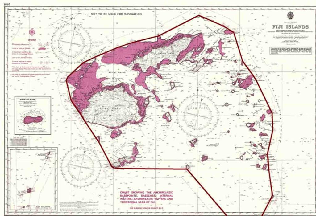
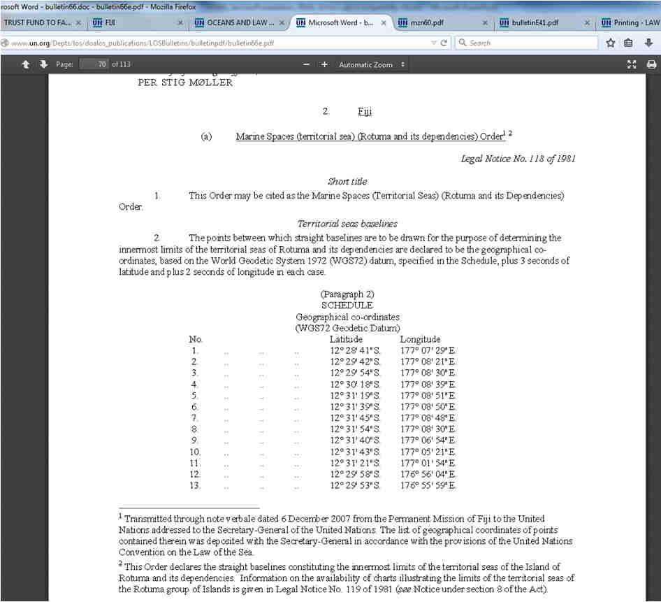
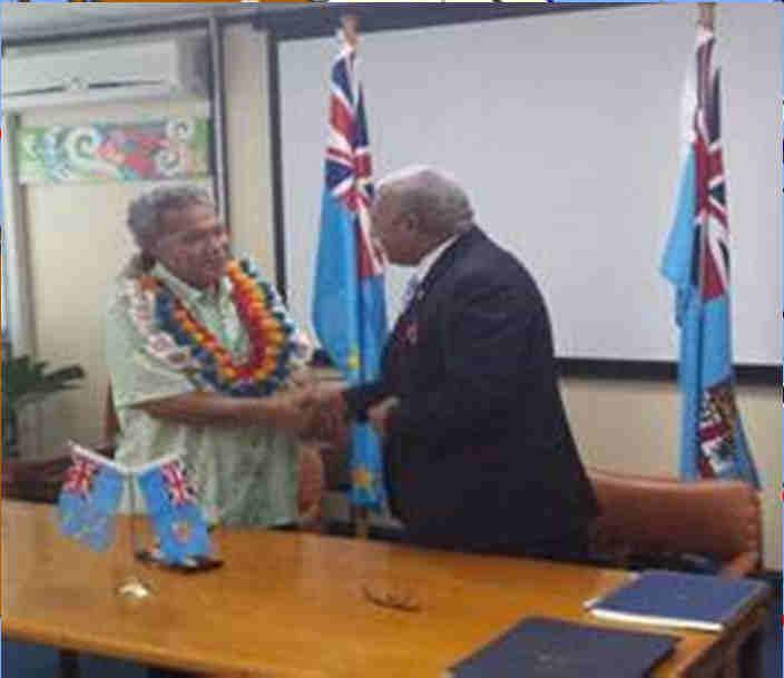
6 Fiji
7 Regional Maritime Boundaries Project background Started in the late 1990s under the fisheries programme at Forum Fisheries Agency (FFA) based in Honiara, Solomon Islands Governing Council agreed to transfer the Project to the South Pacific Applied Geoscience Commission (SOPAC) in 2000 Project is funded by the Government of Australia Project staff: 1 Technical officer (Full time) + 1 Senior Project Officer: Surveying (Part-time) Team Unit Manager, Programme Administrator
8 Regional Maritime Boundaries Unit 1. Baseline development definition of low water line along edge of reef, or outer most edge of outlying islands and drying reefs of an archipelago using best available datasets. 2. Maritime Zones development calculating the zones of the 12 nautical miles (Territorial Sea), 24 nautical miles (Contiguous Zone) and the 200 nautical miles(exclusive Economic Zone). 3. Technical solutions prepared with PICs for shared/overlapping EEZs 4. Extended Continental Shelf activities (ECS) extending the seabed territory beyond the 200 nautical miles(eez).
9 Source Data & Information Hydrographic Charts Topographical Maps Satellite Imagery Aerial Photographs Promulgated Baselines (& treaties)


10 Capacity Building Since 2002, SPC has been building the capacity of Pacific Island surveyors, cartographers to develop the baseline and the outer limits of the maritime zones


11 Regional MB working sessions Since 2007, the SPC Regional Maritime Boundaries Unit has been working with country teams, Geoscience Australia & other technical partners in a series of working sessions to develop PICs submissions in relation to the Extended Continental Shelf (ECS) claims and the development of the Maritime Boundaries. The intensive face to face training with PICs., the funding grants by the Government of Australia and the good will of many people and institutions have been instrumental in facilitating these workshops
 Successfully built a community of maritime")

12 14 th Pacific Islands Maritime Boundaries Working Session (December 2015) Successfully built a community of maritime boundary technical and legal expertise in the region who lead in their national Maritime boundary negotiations in their respective countries


13 Treaty Development opportunities An excellent example of a successful partnerships between regional organisations and testament to the excellent relationships between Pacific Island neighbours.


14 Treaty Development (2012) Marshall Islands, Kiribati and Nauru meeting This trilateral meeting was funded by the Forum Fisheries Agency (FFA) and held at the Geoscience Division of SPC in April 2012
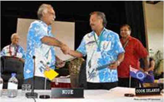
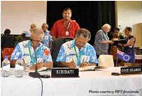
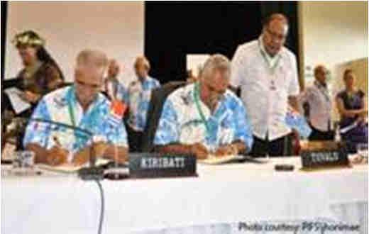
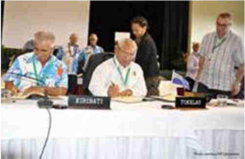
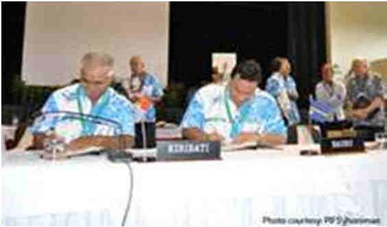
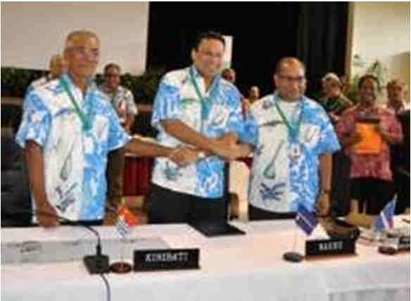
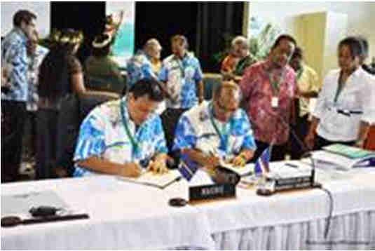

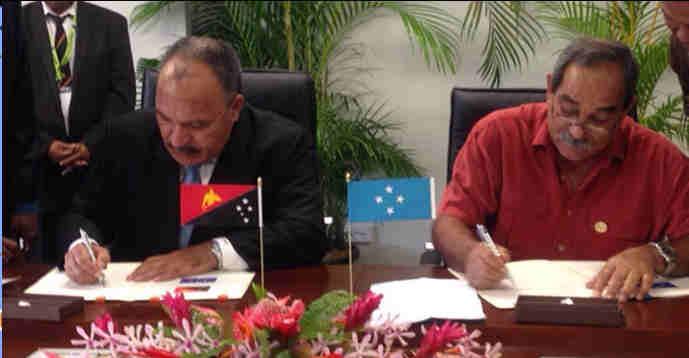
15 Milestone:Signingofthe7Bilateral MaritimeBoundaries,2012ForumMeeting NIUE & COOK IS KIRIBATI & COOK IS KIRIBATI & TUVALU KIRIBATI & TOKELAU KIRIBATI & NAURU NAURU & MARSHALL IS KIRIBATI & MARSHALL IS KIRIBATI NAURU-MARSHALL IS


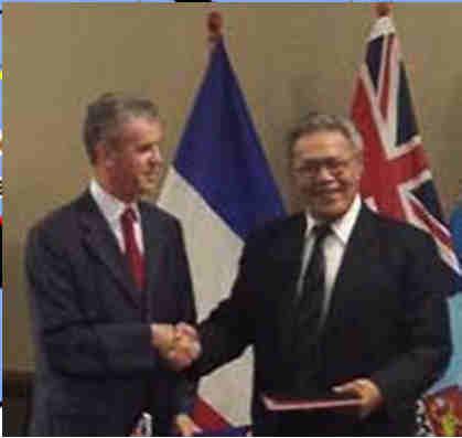
16 USA Kiribati Maritime Boundary (2013) Technical and legal meeting hosted at the Geoscience Division of SPC in May 2013 This bilateral meeting was funded by the Forum Fisheries Agency (FFA) who also provided legal advice to the Kiribati team, and technical advice provided by SPC Maritime Boundaries team
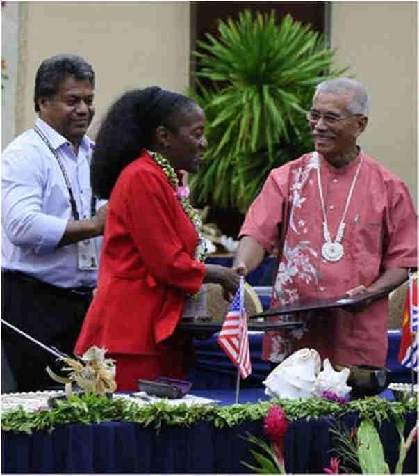
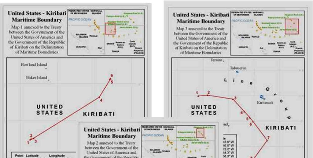
17 SigningoftheKiribatiandUSA Maritimetreaty,ForumMeeting,2013
 Technical")


18 USA FSM Maritime Boundary negotiations (2014) Technical and legal meeting hosted by the US in Hawaii in April 2014 (FSM team officials travel costs were supported by the Forum Fisheries Agency)


19 Signed maritime boundary treaties Sept 2015 Sept 2015 October 2014


20 Deposit of MB information International Declaration -

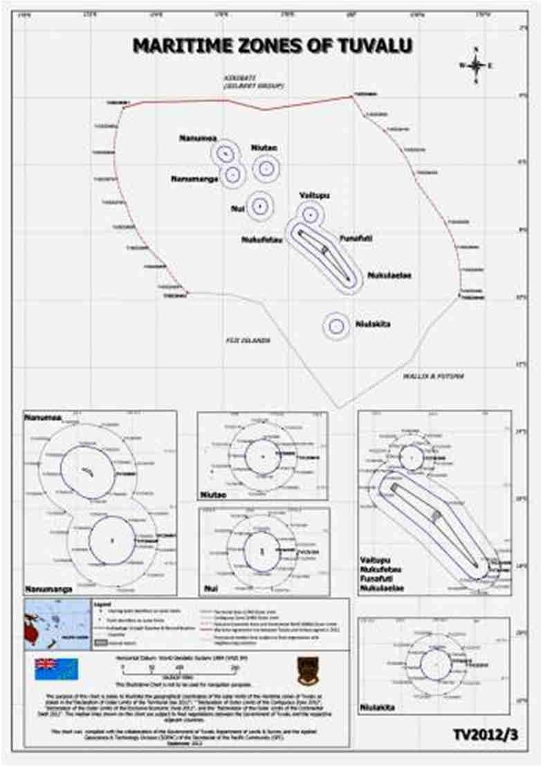
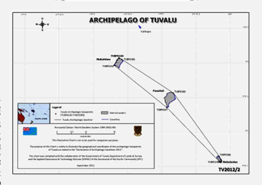
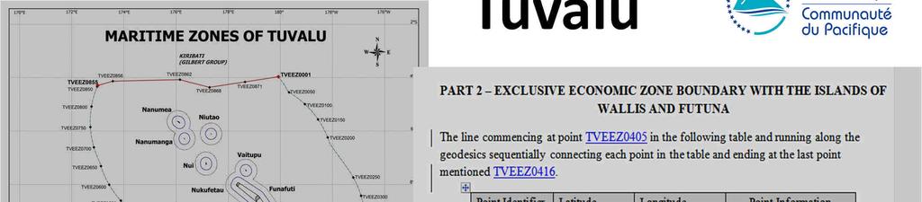
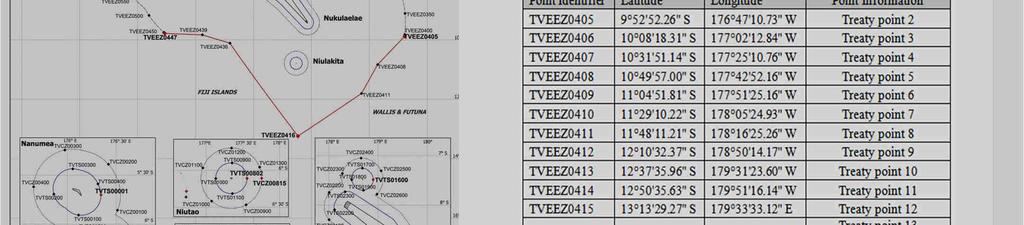
21 Tuvalu National Declaration -


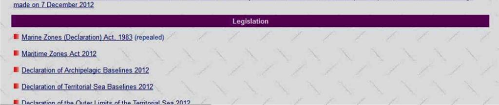
22 Maritime Legislation for Kiribati deposited with the UN in December 2014 International Declaration -


23 Maritime Legislation for Marshall Islands deposited with the UN in April 2016 International Declaration -


24 Overall Regional progress in implementing UNCLOS and the PICs maritime boundaries
25 Lessons learnt Lack of legal capacity within the Project Drafting new legislation(and replacing out-dated maritime spaces legislations) to allow the use of latest and more accurate technical/geodetic datasets in the development of PIC maritime boundaries work. Given this lack of legal capacity within the Unit, the Geoscience Division sought legal advice and support from the Australian Attorney General s Department in early 2011 SPC also strengthened its collaboration with the Forum Fisheries Agency (FFA) and the Commonwealth Secretariat.
26 Issues Requires the political will and support of National Governments (groundworkhastakenthepast10yearsofthisproject) There are certain technical and legal capacity constraints within the project teams(trained staff get promoted internally) Sovereign issue but it is heavily dependent on regional support and assistance (cost of field surveys to collect data, purchase of satellite imagery, etc.) National Maritime Laws and Legislation needs to be reviewed and updated to reflect the technical datasets being used to develop the baselines and maritime zones The 10 project countries who have submitted their claims for Extended Continental Shelf (under Article 76 of UNCLOS) are facing capacity constraints in the process of the defence of the theseclaimstotheun.


27 Status of efforts at regional scale as compared to efforts at the national scale
28 Why is it important? The clear definition of the limits of the maritime jurisdiction is important as it provides the legal framework for the governance of maritime space and the management of the valuable marine resources within the country s national jurisdiction areas: Fisheries management Deep sea minerals development Security Biodiversity Conservation Research Transport Vessel monitoring


29 Fisheries Management Formalising the shared boundaries between neighbouring countries; AND Declaring the outer limits of the EEZs which borders with the high seas

 in a legal manner and deposit this")
30 Future Challenges Increasing reports of IUU fishing activities in the region Leaders need to formally establish their maritime boundaries (including signed treaties for overlapping EEZs) in a legal manner and deposit this information with the UN.


")
31 Future Challenges Tools, Technology to combat IUU using effective methods of Monitoring, Control and Surveillance(MCS) is improving


32 Future Challenges Deep Sea Mining Implications Application and approval of mining leases for seabed exploration and exploitation within a country s EEZ and also in the Area

33 Deep sea minerals development The Area

34 Regional support for remaining Negotiations (14 shared EEZs yet to be finalised) Country visit to Palau in March 2015 for a national consultation workshop. Outcome was to develop a strategy paper for the national taskforce to consider in upcoming negotiations. SPC & FFA provided technical & legal assistance to the delegation from Palau during the fourth (4 th ) round of negotiations between Palau and Indonesia in July 2015.
 Current funding mechanism (via the Enhancing Pacific Ocean Governance EPOG) from Government of Australia for the regional workshops")
35 Future Directions (for Project) BuildonacommonplatformtosharelegalMB,Treaties(GIS layers) with other stakeholders(ffa VMS, etc.) Current funding mechanism (via the Enhancing Pacific Ocean Governance EPOG) from Government of Australia for the regional workshops ceases in 2016
36 POLICY (at regional level) Pacific Oceanscape Framework (2010)- to protect, manage and sustain the cultural and natural integrity of the ocean for present and future generations and for the broader global community. 6 strategic priorities identified for the implementation: establishing jurisdictional rights and responsibilities, fostering good ocean governance, supporting sustainable development, management and conservation, promoting listening, learning, liaising and leading, sustaining action, and facilitating adaptation to a rapidly changing environment.
37 POLICY (at regional level) The Palau Declaration The Ocean: Life & Future Charting a Course to Sustainability(2014) AnnexB 10. We call for strengthened regional efforts to fix baselines and maritime boundaries to ensure that the impact of climate change and sea level rise does not result in reduced jurisdiction.


38 Thank you Emily Artack
Pacific Islands Regional Maritime Boundaries Project the latest Update. Malakai Vakautawale (Mr) Maritime Boundaries Adviser
 Maritime Boundaries Adviser") Pacific Islands Regional Maritime Boundaries Project the latest Update Malakai Vakautawale (Mr) Maritime Boundaries Adviser Consortium Partners 2 What we do? Provide technical advice and support on MB
Pacific Islands Regional Maritime Boundaries Project the latest Update Malakai Vakautawale (Mr) Maritime Boundaries Adviser Consortium Partners 2 What we do? Provide technical advice and support on MB
Pacific Islands Regional Maritime Boundaries Project
 Pacific Islands Regional Maritime Boundaries Project Presented By Filimoni Yaya (Andrick Lal, Sachindra Singh, Emily Artack) Geoscience Division Pacific Community (SPC Geoscience Division, GSD STAR Sessions,
Briefing document of the status of maritime boundaries in Pacific island countries
 Secretariat of the Pacific Community Seventh Heads of Fisheries Meeting (28 Feb. 4 March 2011, Noumea, New Caledonia) Working Paper 5 Original: English Briefing document of the status of maritime boundaries
Pacific Geospatial and Surveying Council (PGSC) Geospatial and GNSS CORS Infrastructure Forum. Kuala Lumpur October
 Geospatial and GNSS CORS Infrastructure Forum. Kuala Lumpur October") Pacific Geospatial and Surveying Council (PGSC) Geospatial and GNSS CORS Infrastructure Forum. Kuala Lumpur 16-17 October Beginning and Progress Members PGSC Charter PGSC Strategy 2017-2027 Meetings Geodetic
Pacific Geospatial and Surveying Council (PGSC) Geospatial and GNSS CORS Infrastructure Forum. Kuala Lumpur 16-17 October Beginning and Progress Members PGSC Charter PGSC Strategy 2017-2027 Meetings Geodetic
Niue Maritime Boundaries Delimitation Project. Christchurch FIGMM
 Niue Maritime Boundaries Delimitation Project Christchurch FIGMM 30 th April 6 th May 2016 Hubert Mana Kalauni Secretary for Justice Department of Justice, Lands and Survey Ministry of Social Services
Faatasi Malologa (PGSC Chair) Director Department of Lands & Survey, Tuvalu
 Director Department of Lands & Survey, Tuvalu") Seventh Session of the United Nations Committee of Experts on Global Geospatial Information Management (UN-GGIM) - 31 July -4 August 2017 Faatasi Malologa (PGSC Chair) Director Department of Lands & Survey,
Seventh Session of the United Nations Committee of Experts on Global Geospatial Information Management (UN-GGIM) - 31 July -4 August 2017 Faatasi Malologa (PGSC Chair) Director Department of Lands & Survey,
Pacific Oceanscape Vision:
 Oceania is vast, Oceania is expanding, Oceania is hospitable and generous, Oceania is humanity rising from the depths of brine and regions of fire deeper still, Oceania is us. We are the sea, we are the
A Pacific Regional Economics of Climate Change Study: Assessing adaptation needs in Small Island Developing States
 Regional Economics of Climate Change: Practitioners Workshop 4-5 March 2009 Washington, DC, USA A Pacific Regional Economics of Climate Change Study: Assessing adaptation needs in Small Island Developing
Clive Schofield * and David Freestone **
 Holding Back the Waves: Options to Secure Maritime Jurisdictional Claims in the Face of Sea Level Rise Clive Schofield * and David Freestone ** *Australian National Centre for Ocean Resources and Security
IMA s ROLE IN COASTAL AND OCEAN GOVERNANCE IN TRINIDAD AND TOBAGO
 IMA s ROLE IN COASTAL AND OCEAN GOVERNANCE IN TRINIDAD AND TOBAGO Presented by Rahanna Juman, Deputy Director (Ag.) About the Institute of Marine Affairs Institute of Marine Affairs (IMA) was established,
Applied Geoscience and Technology Division SOPAC. Joy Papao, Risk Information Systems Officer
 Joy Papao, Risk Information Systems Officer Secretariat of the Pacific Community SPC 22 Pacific Island States Head office in Noumea, New Caledonia 2 Regional offices (Pohnpei and Honiara) 600 staff 9 Technical
Ocean Governance and the Japanese Basic Act on Ocean Policy
 Ocean Governance and the Japanese Basic Act on Ocean Policy Hiroshi Terashima Executive Director Ocean Policy Research Foundation 14 April 2009 The United Nations Nippon Foundation Fellowship Programme
Ocean governance in Samoa: A case study of ocean governance in the South Pacific
 Ocean governance in Samoa: A case study of ocean governance in the South Pacific Anama Solofa UN-Nippon Nippon Foundation of Japan Fellowship 2009-2010 2010 Outline: I. Ocean governance in the South Pacific
Australia Government Geospatial Capacity Building Efforts in Asia and the Pacific. Dr John Dawson
 Australia Government Geospatial Capacity Building Efforts in Asia and the Pacific Dr John Dawson Presentation Overview About Geoscience Australia Examples of Geospatial Capacity Building Activity Geodesy
Sam Bateman and. State Practice Regarding Straight Baselines In East Asia Legal, Technical and Political Issues in a
 State Practice Regarding Straight Baselines In East Asia Legal, Technical and Political Issues in a Changing Environment Sam Bateman and Clive Schofield The Australian National Centre for Ocean Resources
xxv PART I THE DIVIDED OCEANS: INTERNATIONAL LAW GOVERNING JURISDICTIONAL ZONES 1
 Contents Preface page xv List of Figures xvii List of Tables xviii List of Abbreviations xix Table of Cases xxi Table of Treaties and Instruments xxv PART I THE DIVIDED OCEANS: INTERNATIONAL LAW GOVERNING
JOINT SUBMISSION TO THE COMMISSION ON THE LIMITS OF THE CONTINENTAL SHELF BY TUVALU, THE REPUBLIC OF FRANCE AND NEW ZEALAND (TOKELAU)
") JOINT SUBMISSION TO THE COMMISSION ON THE LIMITS OF THE CONTINENTAL SHELF BY TUVALU, THE REPUBLIC OF FRANCE AND NEW ZEALAND (TOKELAU) TABLE OF CONTENTS i. PREFACE... iii ii. LIST OF FIGURES... iv iii.
JOINT SUBMISSION TO THE COMMISSION ON THE LIMITS OF THE CONTINENTAL SHELF BY TUVALU, THE REPUBLIC OF FRANCE AND NEW ZEALAND (TOKELAU) TABLE OF CONTENTS i. PREFACE... iii ii. LIST OF FIGURES... iv iii.
Requirement for Hydrographic Surveying and Nautical Charting for Small Island Developing States within the South West Pacific Region
 Requirement for Hydrographic Surveying and Nautical Charting for Small Island Developing States within the South West Pacific Region John Maschke September 2013 Overview Welcome Introduction Current Situation
Country Fiche Latvia Updated October 2016
 Country Fiche Latvia Updated October 2016 1. General information Marine area under Latvian jurisdiction includes inland sea waters, Territorial sea (12 nautical miles from the baseline) and exclusive economic
Monitoring Surveys PSLMP COSPPac
 Monitoring Surveys PSLMP COSPPac Andrick Lal, Marika Kalouniviti & Veenil Rattan Science, Technology And Resources (STAR) Conference 26 th 29 th June 2017 Nadi FIJI Geodetic Survey Unit (SPC) Andrick Lal,
Current status of operations of Pacific Islands Climate Outlook Forum (PICOF) Alexander Montoro Technical Expert on Climate and Weather Services
 Alexander Montoro Technical Expert on Climate and Weather Services") Current status of operations of Pacific Islands Climate Outlook Forum (PICOF) Alexander Montoro Technical Expert on Climate and Weather Services Secretariat of the Pacific Regional Environment Programme
Current status of operations of Pacific Islands Climate Outlook Forum (PICOF) Alexander Montoro Technical Expert on Climate and Weather Services Secretariat of the Pacific Regional Environment Programme
Economic and Social Council
 United Nations Economic and Social Council Distr.: General 18 July 2016 Original: English Committee of Experts on Global Geospatial Information Management Sixth session New York, 3-5 August 2016 Item 2
1982 United Nations Convention on the Law of the Sea
 1982 United Nations Convention on the Law of the Sea Article 16, 47, 75, 76 and 84 Article 16, 47, 75, 76 and 84 require Coastal States to deposit geographic information pertaining to their maritime limits
Executive Summary and Recommendations
 ANNEX I: EXECUTIVE SUMMARY AND RECOMMENDATIONS OF THE 12RMSD TWELFTH REGIONAL MEETING OF THE METEOROLOGICAL SERVICE DIRECTORS 30 -JUNE to 6 -JULY 2007 Rarotonga, Cook Islands Executive Summary and Recommendations
Seabed knowledge In support of UN SDGs
 Seabed knowledge In support of UN SDGs Evert Flier Fiskerifaglig forum 2. november 2017 Hydrography & small scale fishing Hydrography in Transition Serving the Maritime Community Hydrography in Transition
Nineteenth SPREP Meeting
 Page 1 SECRETARIAT OF THE PACIFIC REGIONAL ENVIRONMENT PROGRAMME Nineteenth SPREP Meeting Pohnpei, Federated States of Micronesia 04 12 September 2008 Agenda Item 9.2.5: Regional Meteorological Services
Areas Beyond National Jurisdiction (ABNJ) 2016 Regional Leaders Program. March 22 to April 1, 2016 United Nations, New York
 2016 Regional Leaders Program. March 22 to April 1, 2016 United Nations, New York") Areas Beyond National Jurisdiction (ABNJ) 2016 Regional Leaders Program March 22 to April 1, 2016 United Nations, New York Welcome and Introductions Biliana Cicin-Sain President, Global Ocean Forum Vladimir
Areas Beyond National Jurisdiction (ABNJ) 2016 Regional Leaders Program March 22 to April 1, 2016 United Nations, New York Welcome and Introductions Biliana Cicin-Sain President, Global Ocean Forum Vladimir
PACIFIC ISLANDS REGIONAL OCEAN POLICY. A healthy Ocean that sustains the livelihoods and aspirations of Pacific Island communities.
 PACIFIC ISLANDS REGIONAL OCEAN POLICY VISION A healthy Ocean that sustains the livelihoods and aspirations of Pacific Island communities. THIS IS OUR OCEAN 1. The care of the ocean is the responsibility
Positioning in the Pacific Islands
 Positioning in the Pacific Islands Andrick Lal United Nations/Nepal Workshop on the Applications of Global Navigation Satellite Systems Kathmandu - Nepal 15 th December 2016 Presentation Outline Introduction
GIS, Charts and UNCLOS Can they live together?
 GIS, Charts and UNCLOS Can they live together? Bill Hirst 1 and David Robertson 2 Address 1 Geoscience Australia GPO Box 378 Canberra, ACT 2601 Phone: 02 6249 9741 Fax: 02 6249 9939 Email: Bill.Hirst@ga.gov.au
THIRD MEETING OF THE PACIFIC METEOROLOGICAL COUNCIL. Theme: "Sustainable Weather and Climate Services for a Resilient Pacific "
 PMC-3/InformationPaper-1-Provisional Agenda THIRD MEETING OF THE PACIFIC METEOROLOGICAL COUNCIL Theme: "Sustainable Weather and Climate Services for a Resilient Pacific " 20-23 July 2015 Fa'onelua Convention
NUKU ALOFA MINISTERIAL DECLARATION For SUSTAINABLE WEATHER AND CLIMATE SERVICES FOR A RESILIENT PACIFIC. 24th July 2015, Nuku alofa, Tonga
 NUKU ALOFA MINISTERIAL DECLARATION For SUSTAINABLE WEATHER AND CLIMATE SERVICES FOR A RESILIENT PACIFIC 24th July 2015, Nuku alofa, Tonga The First Pacific Ministerial Meeting on Meteorology was held on
Linking Global and Regional Levels in the Management of Marine Areas Beyond National Jurisdiction
 Linking Global and Regional Levels in the Management of Marine Areas Beyond National Jurisdiction South Atlantic Region Session 4: «Experiences, Priorities and Opportunities in the South Atlantic and Indian
MARITIME PLANNING IN PORTUGAL
 MARITIME PLANNING IN PORTUGAL Marta Chantal Ribeiro 2 May 2007 In Portugal there is currently no strategic planning system in force for the maritime area as a whole The maritime area under Portuguese jurisdiction
Chapter 12: Pacific Realm and Polar Futures
 Geography: Realms, Regions and Concepts 15 th Edition By de Blij and Muller Chapter 12: Pacific Realm and Polar Futures Defining the Realm Sea Hemisphere: seas covering nearly an entire hemisphere Fragmented,
Briefing. H.E. Mr. Gyan Chandra Acharya
 Briefing by H.E. Mr. Gyan Chandra Acharya Under-Secretary-General and High Representative for the Least Developed Countries, Landlocked Developing Countries and Small Island Developing States Briefing
HONIARA MINISTERIAL STATEMENT For STRENGTHENING SUSTAINABLE WEATHER, CLIMATE, OCEAN AND WATER SERVICES FOR A RESILIENT PACIFIC
 HONIARA MINISTERIAL STATEMENT For STRENGTHENING SUSTAINABLE WEATHER, CLIMATE, OCEAN AND WATER SERVICES FOR A RESILIENT PACIFIC 18 August 2017, Honiara, Solomon Islands 1. The Second Pacific Ministerial
Economic and Social Council 10 July 2013
 ADVANCE UNEDITED VERSION UNITED NATIONS E/C.20/2013/10/Add.1 Economic and Social Council 10 July 2013 Committee of Experts on Global Geospatial Information Management Third session Cambridge, United Kingdom
Slide 1 Geography: Realms, Regions, and Concepts 15 th Edition. Slide 2. Slide 3 Defining the Realm. Chapter 12: Pacific Realm and Polar Futures
 Slide 1 Geography: Realms, Regions, and Concepts 15 th Edition Chapter 12: Pacific Realm and Polar Futures Slide 2 Slide 3 Defining the Realm Sea Hemisphere: seas cover nearly an entire hemisphere: Fragmented,
Our Sea of Islands Our Livelihoods Our Oceania Framework for a Pacific Oceanscape
 Our Sea of Islands Our Livelihoods Our Oceania Framework for a Pacific Oceanscape Our Sea of Islands Our Livelihoods Our Oceania Framework for a Pacific Oceanscape Table of Contents Framework Purpose...3
Mindful of the interests which the Parties share as immediate neighbours, and in a spirit of cooperation, friendship and goodwill; and
 page 1 Delimitation Treaties Infobase accessed on 13/03/2002 Treaty between the Government of Australia and the Government of the Republic of Indonesia establishing an exclusive economic zone boundary
COMPLICATIONS IN DELIMITING THE OUTER CONTINENTAL SHELF. Ron Macnab Geological Survey of Canada (Retired)
") COMPLICATIONS IN DELIMITING THE OUTER CONTINENTAL SHELF Ron Macnab Geological Survey of Canada (Retired) DISCLAIMER The contents of this presentation are the author s personal views only, and do not represent
COMPLICATIONS IN DELIMITING THE OUTER CONTINENTAL SHELF Ron Macnab Geological Survey of Canada (Retired) DISCLAIMER The contents of this presentation are the author s personal views only, and do not represent
Maritime Spatial Planning: Transboundary Cooperation in the Celtic Seas Looking Ahead
 Maritime Spatial Planning: Transboundary Cooperation in the Celtic Seas Looking Ahead Looking ahead MSP in the context of the European Maritime and Fisheries Fund (EMFF) and beyond SIMCelt Final Conference
State Practice on the Establishment of Multiple Maritime Boundaries: Assessing the Challenges of Separating Seabed and Water Column Boundaries
 State Practice on the Establishment of Multiple Maritime Boundaries: Assessing the Challenges of Separating Seabed and Water Column Boundaries Professor Clive Schofield The Australian National Centre for
REPUBLIC OF THE MARSHALL ISLANDS MARITIME ZONES DECLARATION ACT 2016.
 Republic of the Marshall Islands Maritime Zones Declaration Act 2016. 33MIRCCh.1Index TITLE 33 - MARINE ZONES AND PROTECTION OF MAMMALS CHAPTER 1 - MARITIME ZONE DECLARATION s Republic of the Marshall
FIG Asia Pacific Capacity Development Network
 FIG Asia Pacific Capacity Development Network Report to the 41th General Assembly FIG Congress 2018, Istanbul - Turkey Rob Sarib Chair FIG Asia Pacific Capacity Development Network (AP CDN) Story of the
Natura 2000 in the marine environment: state of implementation and next steps
 Life on the blue planet: biodiversity research and the new European marine policies EPBRS European Platform on Biodiversity Research Strategy Porto, Portugal 7-9 November 2007 Natura 2000 in the marine
Country Fiche Estonia
 Country Fiche Estonia Deleted: October Updated May 2018 Deleted: 7 1. General information Size of internal waters (to the baseline) and territorial sea (12-nm zone from the baseline) approximately 25 200
Valuing and conserving the benefits of marine biodiversity in the South Pacific
 Valuing and conserving the benefits of marine biodiversity in the South Pacific Five years of support for integrated ocean governance in Pacific Island Countries 2 We are the sea, we are the ocean we must
DELIMITATION OF THE MOZAMBIQUE MARITIME BOUNDARIES WITH NEIGHBORING STATES (INCLUDING THE EXTENDED CONTINENTAL SHELF) AND MANAGEMENT OF OCEAN ISSUES
 AND MANAGEMENT OF OCEAN ISSUES") DELIMITATION OF THE MOZAMBIQUE MARITIME BOUNDARIES WITH NEIGHBORING STATES (INCLUDING THE EXTENDED CONTINENTAL SHELF) AND MANAGEMENT OF OCEAN ISSUES Elisio B. Jamine United Nations The Nippon Fellowship
DELIMITATION OF THE MOZAMBIQUE MARITIME BOUNDARIES WITH NEIGHBORING STATES (INCLUDING THE EXTENDED CONTINENTAL SHELF) AND MANAGEMENT OF OCEAN ISSUES Elisio B. Jamine United Nations The Nippon Fellowship
ECONOMIC AND SOCIAL COUNCIL
 UNITED NATIONS E/CONF.102/3 ECONOMIC AND SOCIAL COUNCIL Nineteenth United Nations Regional Cartographic Conference for Asia and the Pacific Bangkok, 29 October 1 November 2012 Item 4 of the provisional
Ocean & Islands Programme May 2007
 1 st RIF level trilateral May 2007 PIROP Pacific Island Regional Ocean Policy & Strategic Action Plan 5 Guiding Principles of PIROP 1. Improving our understanding of the ocean. 2. Sustainably developing
2018/1 The integration of statistical and geospatial information. The Regional Committee of UN-GGIM: Americas:
 The following are the conclusions and recommendations of the Regional Committee of the United Nations on Global Geospatial Information Management for the Americas, during its Fifth Session, Thursday 8
A National Ocean Policy for Malaysia: Rationale and Proposed Components. Mohd Nizam Basiron and Cheryl Rita Kaur Maritime Institute of Malaysia
 A National Ocean Policy for Malaysia: Rationale and Proposed Components Mohd Nizam Basiron and Cheryl Rita Kaur Maritime Institute of Malaysia Outline of Presentation Objectives of Presentation Introduction
HAMILTON DECLARATION ON COLLABORATION FOR THE CONSERVATION OF THE SARGASSO SEA
 HAMILTON DECLARATION ON COLLABORATION FOR THE CONSERVATION OF THE SARGASSO SEA Hamilton, Bermuda 11 March, 2014 WE, THE SIGNATORIES LISTED BELOW: Recognising that the islands of Bermuda are the only land
STATUS OF MARINE SPATIAL DATA INFRASTRUCTURE
 STATUS OF MARINE SPATIAL DATA INFRASTRUCTURE IN PACIFIC ISLAND COUNTRIES 26 th January, 2016 7 th IHO Marine Spatial Data Infrastructure Working Group Meeting Tokyo Sachindra Singh Senior Geospatial Systems
Council conclusions on Arctic issues. 2985th FOREIGN AFFAIRS Council meeting Brussels, 8 December 2009
 COU CIL OF THE EUROPEA U IO EN Council conclusions on Arctic issues 2985th FOREIGN AFFAIRS Council meeting Brussels, 8 December 2009 The Council adopted the following conclusions: The Council recalls its
EUSAIR on sea topics from Slovenian perspective
 MINISTRY OF FOREIGN AFFAIRS REPUBLIC OF SLOVENIA EUSAIR on sea topics from Slovenian perspective Mag. Andreja Jerina National Coordinator 4 EU MRS: 270 millions of population 19 MS 12 non MS Sea basin
Marine/Maritime Spatial Planning Andrej Abramić
 Marine/Maritime Spatial Planning Andrej Abramić EcoAqua SUMMER SCHOOL: Ecosystem approach to aquaculture 26-29th of October 2015 Research and Technology to enhance excellence in Aquaculture development
MARINE SPATIAL PLANNING & MARINE CADASTRE: CHALLENGES AND ISSUES
 MARINE SPATIAL PLANNING & MARINE CADASTRE: CHALLENGES AND ISSUES Roger Longhorn Secretary General, GSDI Association rlonghorn@gsdi.org Member, IHO Marine SDI Working Group ral@alum.mit.edu Member, UNESCO
Indonesia s Internal Maritime Boundaries
 University of Wollongong-Lecture in Boundaries, November 2005 Indonesia s Internal Maritime Boundaries 1 Lecture Outline Indonesia's internal maritime boundaries Law no. 22/1999 --> Law no. 32/2004 Technical
Sharing the Resources of the South China Sea
 Sharing the Resources of the South China Sea MARK J. VALENCIA Senior Fellow, East-West Center, Honolulu, Hawaii, U.SA. JON M. VAN DYKE Professor oflaw, Wm. S. Richardson School oflaw, University of Hawaii,
EXECUTIVE SUMMARY A SUBMISSION OF DATA AND INFORMATION ON THE OUTER LIMITS OF THE CONTINENTAL SHELF OF THE REPUBLIC OF NIGERIA PURSUANT TO
 EXECUTIVE SUMMARY A SUBMISSION OF DATA AND INFORMATION ON THE OUTER LIMITS OF THE CONTINENTAL SHELF OF THE REPUBLIC OF NIGERIA PURSUANT TO PART VI OF AND ANNEX II TO THE UNITED NATIONS CONVENTION ON THE
The Relevance of Hydrography to UNCLOS; an Indonesian Perspective By: Prof. Dr. Hasjim Djalal, MA*
 The Relevance of Hydrography to UNCLOS; an Indonesian Perspective By: Prof. Dr. Hasjim Djalal, MA* As I understand it, the theme of this 6 th ABLOS Conference 2010 is Contentious Issues in UNCLOS- surely
ECONOMIC AND SOCIAL COUNCIL 10 July 2007
 UNITED NATIONS E/CONF.98/CRP.22 ECONOMIC AND SOCIAL COUNCIL 10 July 2007 Ninth United Nations Conference on the Standardization of Geographical Names New York, 21-30 August 2007 Item 9(a) of the provisional
The OSCE s Role in Trade and Transport Facilitation
 1 The OSCE s Role in Trade and Transport Facilitation Roel Janssens,, Economic and Environmental Adviser Office of the Co-ordinator ordinator of OSCE Economic and Environmental Activities 14 th OSCE Economic
E/CONF.105/115/CRP.115***
 E/CONF.105/115/CRP.115*** 30 June 2017 Original: English 11 th United Nations Conference on the Standardization of Geographical Names New York, 8-17 August 2017 Item 9a) of the provisional agenda* National
CONFERENCE STATEMENT
 Final draft CONFERENCE STATEMENT We, the elected representatives of Canada, Denmark/Greenland, the European Parliament, Finland, Iceland, Norway, Russia, Sweden and the United States of America; In collaboration
MAPS AND COORDINATES...
 Table of Contents 1 INTRODUCTION... 2 2 MAPS AND COORDINATES... 3 3 ADVISORY ASSISTANCE FROM COMMISSION MEMBERS... 3 4 PROVISIONS OF ARTICLE 76 INVOKED... 3 5 OUTSTANDING MARITIME DELIMITATIONS... 4 6
Report of the Regional Committee of UN-GGIM for Asia and the Pacific (UN-GGIM-AP)
") Report of the Regional Committee of UN-GGIM for Asia and the Pacific (UN-GGIM-AP) At the Eighth Session of UN-GGIM UN Headquarters, New York, 1 3 August 2018 About UN-GGIM-AP One of the five regional committees
Report of the Regional Committee of UN-GGIM for Asia and the Pacific (UN-GGIM-AP) At the Eighth Session of UN-GGIM UN Headquarters, New York, 1 3 August 2018 About UN-GGIM-AP One of the five regional committees
Item 9.1 The Pacific Meteorological Desk Partnership (PMDP) Salesa Nihmei and Alex Montoro SPREP
 Salesa Nihmei and Alex Montoro SPREP") 1993 RMSD-1 Item 9.1 The Pacific Meteorological Desk Partnership (PMDP) Salesa Nihmei and Alex Montoro SPREP Content Who/what is the PMDP Partnerships The Pacific Met. Strategy Pacific Meteorological
1993 RMSD-1 Item 9.1 The Pacific Meteorological Desk Partnership (PMDP) Salesa Nihmei and Alex Montoro SPREP Content Who/what is the PMDP Partnerships The Pacific Met. Strategy Pacific Meteorological
Policy framework The Netherlands and the Polar Regions, Summary and priorities
 Policy framework The Netherlands and the Polar Regions, 2011-2015 Summary and priorities The policy outlined in this Policy Framework for the Polar Regions (2011-2015) is part of the government s orientation
Marine Spatial Planning (MSP): A practical approach to ecosystembased
: A practical approach to ecosystembased") Marine Spatial Planning (MSP): A practical approach to ecosystembased management Erik Olsen, Institute of Marine Research, Norway Fanny Douvere, International Oceanographic Commission Overview Why we need
Marine Spatial Planning (MSP): A practical approach to ecosystembased management Erik Olsen, Institute of Marine Research, Norway Fanny Douvere, International Oceanographic Commission Overview Why we need
SIXTH REGULAR SESSION, 2017 C.B. NO A BILL FOR AN ACT
 NINETEENTH CONGRESS OF THE FEDERATED STATES OF MICRONESIA SIXTH REGULAR SESSION, 0 C.B. NO. - A BILL FOR AN ACT To amend title of the code of the Federated States of Micronesia by amending existing sections
MODELS AND TOOLS FOR GOVERNANCE OF
 Working Papers Collection No. 1/2015 MODELS AND TOOLS FOR GOVERNANCE OF THE ADRIATIC AND IONIAN SEAS www.unimc.it/maremap NATIONAL POLITICS AND EU POLITICS: THE MARITIME SPATIAL PLANNING AND INTEGRATED
Background Document: Report of the Regional Committee of United Nations Global Geospatial Information Management for Asia and the Pacific
 Background Document: Report of the Regional Committee of United Nations Global Geospatial Information Management for Asia and the Pacific 1. Summary 1. This report highlights the activities carried out
Community based approaches to natural resource management governance and the role of government
 Community based approaches to natural resource management governance and the role of government Hugh Govan LMMA Network Content A challenge An opportunity Recent progress in (M)PA development A workable
Marine Spatial Planning in Hellas; Recent Facts and Perspectives
 XXV FIG CONGRESS Engaging the Challenges, Enhancing the Relevance Kuala Lumpur, Malaysia 16 21 June 2014 Marine Spatial Planning in Hellas; Recent Facts and Perspectives Mrs. Chaiditsa BOLANOU Surveying
KUNMING FORUM ON UNITED NATIONS GLOBAL GEOSPATIAL INFORMATION MANAGEMENT CITIES OF THE FUTURE: SMART, RESILIENT
 KUNMING FORUM ON UNITED NATIONS GLOBAL GEOSPATIAL INFORMATION MANAGEMENT CITIES OF THE FUTURE: SMART, RESILIENT and SUSTAINABLE Yunnan Zhenzhuang Guest House, Kunming, China 10 12 May 2017 BACKGROUND CONCEPT
THE SEVILLE STRATEGY ON BIOSPHERE RESERVES
 THE SEVILLE STRATEGY ON BIOSPHERE RESERVES 1 VISION FOR BIOSPHERE RESERVES IN THE 21 ST CENTURY The international Seville Conference on Biosphere Reserves, organised by UNESCO, adopted a two-pronged approach,
World Oceans Day 2010 Our oceans: opportunities and challenges
 World Oceans Day 2010 Our oceans: opportunities and challenges Roundtable discussion on the United Nations Convention on the Law of the Sea fifteen years after its entry into force HOW EFFECTIVELY IS UNCLOS
Tore Henriksen a & Geir Ulfstein b a Faculty of Law, University of Tromsø, Tromsø, Norway. Available online: 18 Feb 2011
 This article was downloaded by: [Bibliotheek van het Vredespaleis] On: 03 May 2012, At: 03:44 Publisher: Taylor & Francis Informa Ltd Registered in England and Wales Registered Number: 1072954 Registered
Maritime Spatial Planning Framework Directive Supported by INSPIRE
 Maritime Spatial Planning Framework Directive Supported by INSPIRE Andrej Abramić, Vanda Nunes de Lima, Paul Smits, Emanuele Bigagli, Chris Schubert European Commission Joint Research Centre Institute
JCOMM-CHy Coastal Inundation Forecasting Demonstration Project (CIFDP)
") WMO World Meteorological Organization Working together in weather, climate and water JCOMM-CHy Coastal Inundation Forecasting Demonstration Project (CIFDP) Coastal Flooding & Vulnerable Populations Coastal
WMO World Meteorological Organization Working together in weather, climate and water JCOMM-CHy Coastal Inundation Forecasting Demonstration Project (CIFDP) Coastal Flooding & Vulnerable Populations Coastal
Marine Spatial Planning in the Baltic Sea Region
 Marine Spatial Planning in the Baltic Sea Region Towards coherence and cross-border solutions in Baltic Maritime Spatial Plans Coordinator & Project manager Dr Ingela Isaksson Swedish Agency for Marine
Maritime Boundary Negotiations National Considerations Dr. Robert W. Smith
 Maritime Boundary Negotiations National Considerations Dr. Robert W. Smith ABLOS: ADDRESSING DIFFICULT ISSUES IN UNCLOS 28 OCTOBER 2003 Practical Steps in the Negotiating Process 1. The Delimitation Process
Country Report Vanuatu
 Country Report Vanuatu Ministry Infrastructure and Public Utilities. Application of Space Technology and the Geographic information system for DRR and Sustainable Development 18 th 22 nd December 2012
Economic and Social Council
 United Nation E/C.20/2012/4/Add.1 Economic and Social Council Distr.: General 2 July 2012 Original: English Committee of Experts on Global Geospatial Information Management Second session New York, 13-15
OUTER CONTINENTAL SHELF CLAIMS IN THE ARCTIC. Presentation given by Dr. Kamrul Hossain ASA University Bangladesh 15 March 2010
 OUTER CONTINENTAL SHELF CLAIMS IN THE ARCTIC Presentation given by Dr. Kamrul Hossain ASA University Bangladesh 15 March 2010 Contents Historical background of the continental shelf Concept of continental
Dorset MSP Evidence Base 18 th February Ness Smith C-SCOPE Project Officer
 Dorset MSP Evidence Base 18 th February 2011 Ness Smith C-SCOPE Project Officer Sectoral Topic Papers MMA Description document gives an overview of the area, it s physical and human influences 20 Topic
PRIORITY TWO-YEAR ACTIVITIES ( ) PRIORITY ONE: INTERNATIONAL RECOGNITION OF ECOLOGICAL IMPORTANCE
 PRIORITY ONE: INTERNATIONAL RECOGNITION OF ECOLOGICAL IMPORTANCE") PREFACE: The Work Programme goals and priority activities were developed at the Second Joint Meeting of the Signatories to the Hamilton Declaration and the Sargasso Sea Commission, held in Key West Florida,
PREFACE: The Work Programme goals and priority activities were developed at the Second Joint Meeting of the Signatories to the Hamilton Declaration and the Sargasso Sea Commission, held in Key West Florida,
CONFERENCE OF PARLIAMENTARIANS OF THE ARCTIC REGION. UN LOS Convention and the extended continental shelf in the Arctic
 CONFERENCE OF PARLIAMENTARIANS OF THE ARCTIC REGION UN LOS Convention and the extended continental shelf in the Arctic Presentation given by Dr. Kamrul Hossain Finnish Parliament 18 November 2009 Contents
PACIFIC ISLANDS APPLIED GEOSCIENCE COMMISSION
 PACIFIC ISLANDS APPLIED GEOSCIENCE COMMISSION MARINE SURVEY AND MAPPING ACTIVITIES, 2009-2010 SOPAC Report to the South West Pacific Hydrographic Commission (SWPHC) 10 th IHO SWPHC Conference, Honiara,
Geological Survey of Canada Lands and Minerals Sector Natural Resources Canada OneGeology, June 2018
 Geological Survey of Canada Lands and Minerals Sector Natural Resources Canada OneGeology, June 2018 Geological Survey of Canada Mission The Geological Survey of Canada provides public geoscience knowledge
UN-GGIM: Strengthening Geospatial Capability
 Fifth Plenary Meeting of UN-GGIM: Europe Brussels, 6-7 June 2018 UN-GGIM: Strengthening Geospatial Capability Walking the talk to leave no one behind Greg Scott, UN-GGIM Secretariat Environmental Statistics
2012 FORUM OF MARINE PROTECTED AREAS IN THE MEDITERRANEAN ANTALYA, TURKEY
 2012 FORUM OF MARINE PROTECTED AREAS IN THE MEDITERRANEAN ANTALYA, TURKEY SPECIAL EVENT Challenges for Open Seas MPAs in the Mediterranean region November 27, 2012. 15h00-16H00 Slide # 1 2012 FORUM OF
National Perspectives - Portugal. Margarida Almodovar
 National Perspectives - Portugal Margarida Almodovar margarida.almodovar@mam.gov.pt from base line to the external limit of the continental shelf behind 200 miles and according to UNCLOS definitions Economic
Country Fiche Lithuania
 Country Fiche Lithuania Updated June 2018 1. General information The Lithuanian maritime space is delimited by the Decree of the Government of the Republic of Lithuania of 6 December, 2004, No. 1597 and
NOAA Nautical Charts and Coastal and Marine Spatial Planning. Meredith Westington Chief Geographer NOAA/NOS/Office of Coast Survey
 NOAA Nautical Charts and Coastal and Marine Spatial Planning Meredith Westington Chief Geographer NOAA/NOS/Office of Coast Survey Ocean Policy Task Force What is CMSP? A comprehensive, adaptive, integrated,
This Book Belonged to
 THE AMERICAN UNIVERSITY Washington College of Law Library This Book Belonged to The Private Collection of Judge Richard R, Baxter I THE AMERICAN UNIVERSITY Washington College of Law Law Library W-, D.C.