Final Survey/Data Report
|
|
|
- Erick Lambert Alexander
- 5 years ago
- Views:
Transcription


1 US ARMY CORPS OF ENGINEERS New England District Contract No. DACW33-03-D-004 Delivery Order No. 05 November 2004 Final Survey/Data Report Boston Harbor Deep Draft Navigation Improvement Project Biological Resource Surveys Benthic Infauna Collection Survey
2 FINAL SURVEY/DATA REPORT BOSTON HARBOR DEEP DRAFT NAVIGATION IMPROVEMENT PROJECT BIOLOGICAL RESOURCE SURVEYS BENTHIC INFAUNA COLLECTION SURVEY Contract Number DACW33-03-D-004 Delivery Order No. 05 To: U.S. Army Corps of Engineers North Atlantic Division New England District 696 Virginia Road Concord, MA Prepared by: Battelle 397 Washington Street Duxbury, MA (781) November 2004
3 Final Benthic Infauna Collection Survey Report November 2004 Boston Harbor Biological Resources Surveys Page i TABLE OF CONTENTS 1.0 INTRODUCTION METHODS Grab Sampling Processing Infaunal Samples Grain Size and TOC Samples Grain Size and TOC Analyses Deviations SURVEY CHRONOLOGY SURVEY RESULTS Grab Sample Collection Information Grain Size and TOC Results PROBLEMS EXPERIENCED, ACTIONS TAKEN, AND RECOMMENDATIONS Technical REFERENCES...7 LIST OF TABLES Table 1. Survey Personnel for Sediment Sampling...1 Table 2. Benthic Infauna Station Coordinates...4 Table 3. Results of TOC Analyses...6 Table 4. Results of Grain Size Analyses...6 LIST OF FIGURES Figure 1. Benthic Sampling Areas...8 Figure 2. Benthic Stations, Magnolia...9 Figure 3. Benthic Stations, Nahant Bay...10 Figure 4. Benthic Stations, Broad Sound...11 Figure 5. Benthic Stations, Massachusetts Bay...12 Figure 6. Benthic Stations, Nantasket Roads...13 APPENDICES Appendix 1. Field Station Logs Appendix 2. Chain of Custody Logs Appendix 3. Results of Grain Size and TOC Analyses
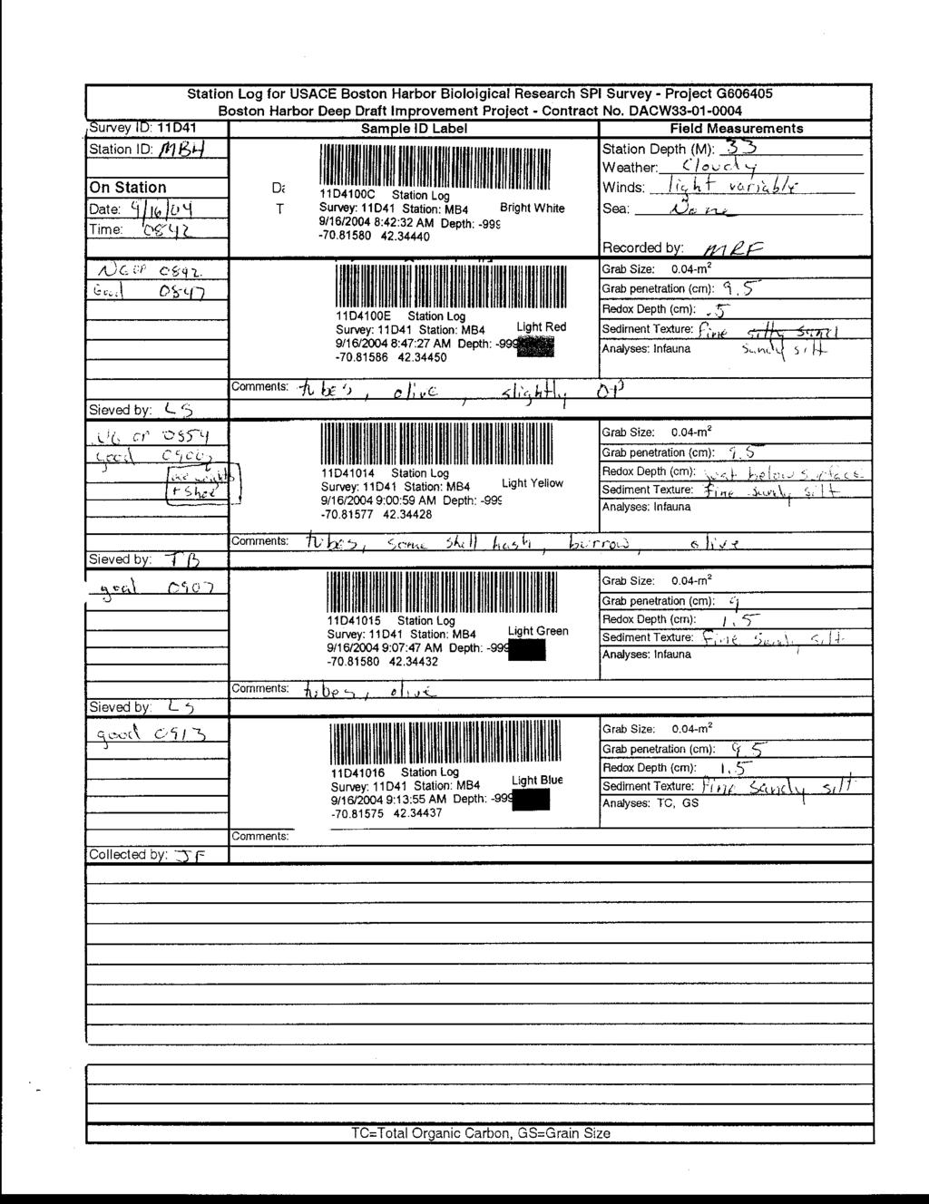
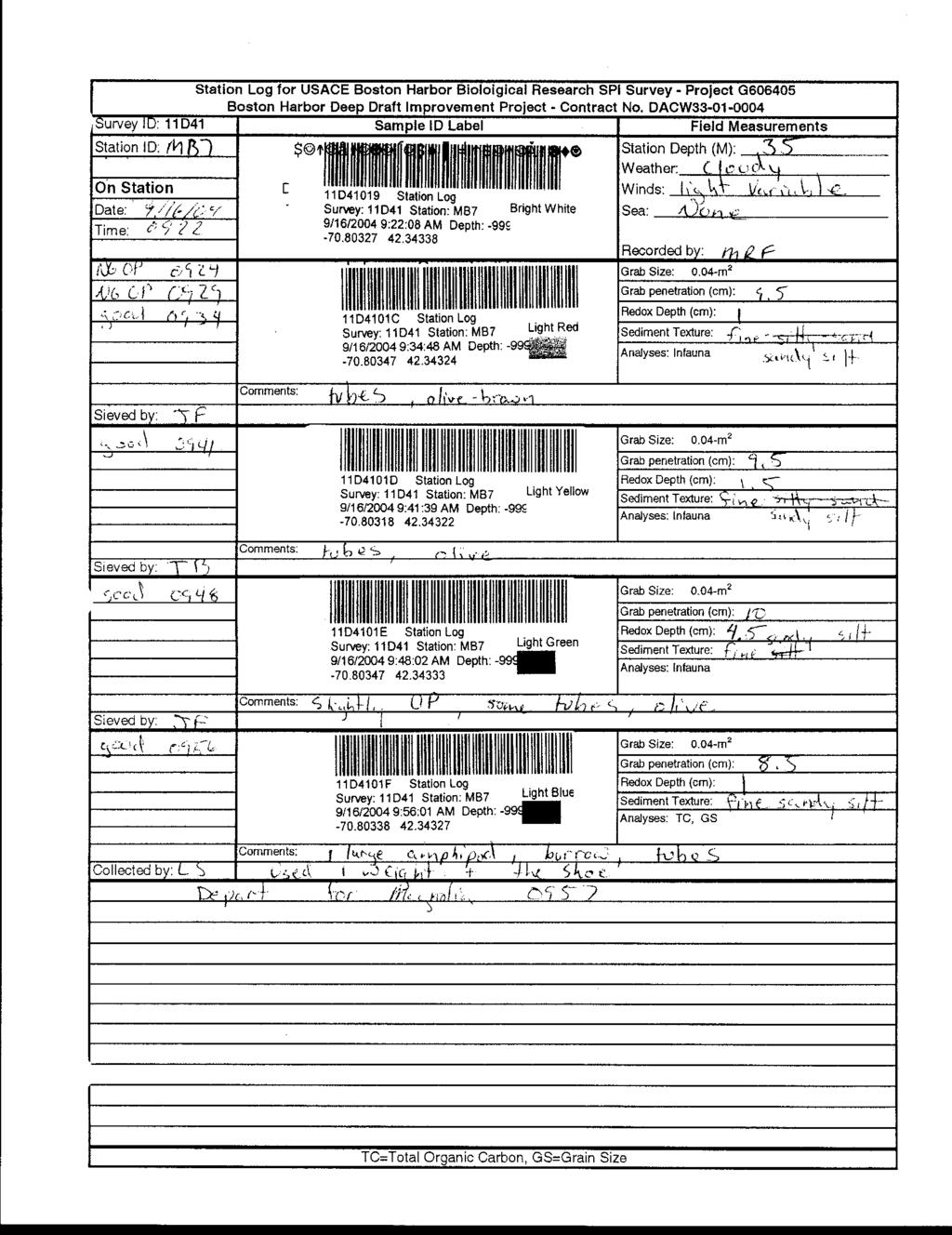
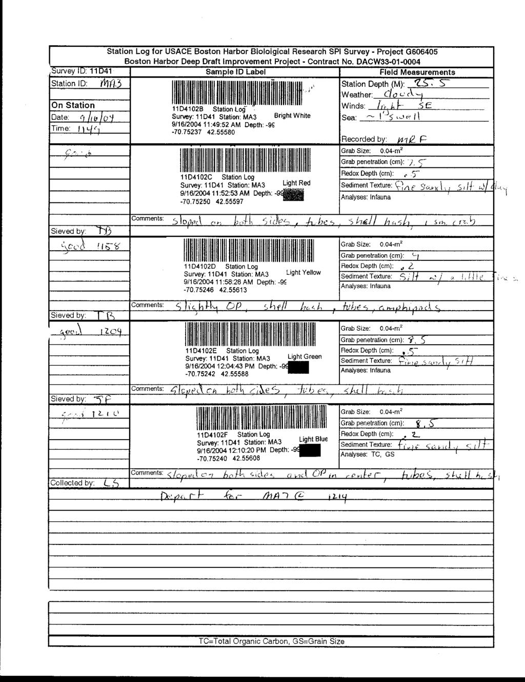
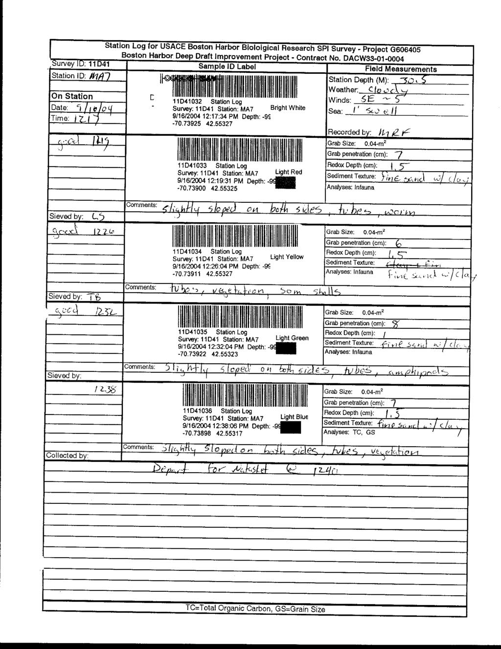
4 Final Benthic Infauna Collection Survey Report November 2004 Boston Harbor Biological Resources Surveys Page INTRODUCTION On September 16 and 17, 2004 sediment grab sampling was conducted at 15 stations within five areas in and around Boston Harbor, MA. The five areas have been proposed for hard bottom habitat creation by the U. S. Army Corps of Engineers, New England District (USACE). The survey information will be used in conjunction with a sidescan survey and a sediment profile imaging (SPI) survey to describe the benthic community. The R/V Aquamonitor, owned and operated by Battelle Memorial Institute, served as a sampling platform for the survey. Mr. Robert Ryder captained the vessel. Survey personnel are shown in Table 1. Table 1. Survey Personnel for Sediment Sampling. Activity: Date: Sediment Collection Survey September 16, 2004 Sediment Collection Survey September 17, 2004 Physical Oceanographer C. Gagnon C. Gagnon Facilities Engineer M. Fitzpatrick M. Fitzpatrick Marine Benthic Ecologist L. Short L. Short Marine Benthic Ecologist J. Fahey J. Fahey Marine Benthic Ecologist T. Barber Boat Operator R. Ryder R. Ryder This survey report describes the activities conducted during sampling and provides a synopsis of some preliminary observations from the survey. Figures 1 6 show actual sample collection locations. A description of survey methods is provided in Section 2. A chronological summary of survey activities for sediment sampling is provided in Section 3. Preliminary survey results are provided in Section 4. A description of survey problems and corrective actions, and recommendations for future surveys, can be found in Section METHODS This survey involved collecting benthic infauna samples. Results will be used to (a) determine whether there are differences in benthic community and/or habitat parameters between sites, (b) determine whether there are differences in benthic community and/or habitat parameters associated with differences in grain size of the substrate, and (c) determine which sites are appropriate to support rock rubble by determining the surface and underlying sediment type. Ultimately this data will be used to rank sites for suitability for placement of rock for lobster habitat enhancement. Details on the survey/sampling methods can be found in the Survey Plan for Boston Harbor (Battelle, 2004). 2.1 Grab Sampling Five areas were surveyed in and around Boston Harbor with three stations sampled per area. Station coordinates were determined based on sidescan work provided by CR Environmental
5 Final Benthic Infauna Collection Survey Report November 2004 Boston Harbor Biological Resources Surveys Page 2 (Battelle 2004a) and SPI data collected by Diaz and Daughters (Battelle 2004b) in support of this project. Based on these surveys, three (3) stations were chosen to represent the range of soft bottom sediments within each area. At each of these stations sediment was collected for benthic infauna sample enumeration. Observations for each grab sample include a visual description of the grain size (e.g., silty sand, presence of gravel, etc.), estimate of apparent Redox Potential Depth (RPD), presence of surface features such as shells, mats, etc., presence of biota such as crabs or shellfish, presence of any layering, any problems encountered, and any other descriptive information noted. One grab sample per station was also collected for grain size and total organic carbon (TOC) analyses. 2.2 Processing Infaunal Samples Samples for infaunal analysis were collected with a 0.04-m 2 Young-modified van Veen grab sampler. After the sample was determined to be acceptable and the visual measurements were recorded, the entire sample was washed with filtered seawater from the sampler into a plastic bucket positioned beneath the grab. Any sediment adhering to the surface of the ruler after depth measurements were obtained was also rinsed back into the grab for processing with the remainder of the sample. Grab samples for infaunal analysis were rinsed with filtered seawater through 500-µm mesh sieves. The samples retained on the screens were transferred to labeled jars and fixed in 10% formalin [10 parts saturated solution (37-40%) of aqueous formaldehyde to 90 parts sample/seawater]. No sample jar was more than ½ full of sieved sediment so that there was, at a minimum, an equal volume of 10% formalin/seawater solution overlying the sediment. One teaspoon of borax was added for each liter of fixed sample to buffer the formalin. The jar was gently turned around on its side to distribute the borax and formalin evenly throughout the sample. Sieving technicians initialed the survey log to identify themselves as the sample processor. Sieves were scrubbed with nylon brushes to remove any clinging material between samples. In between stations, the 0.04-m 2 grab sampler was cleaned with soap and water Grain Size and TOC Samples One additional grab sample, as detailed above, was collected at each station. Two subsamples were taken from each these grab samples for analysis of grain size and total organic carbon (TOC). After the grab sample was deemed acceptable and the visual measurements were recorded, the overlying water was siphoned from the grab. The top two centimeters of sediment were removed with a Kynar-coated scoop and homogenized in a clean, glass bowl. The sediment was divided between two subsample containers and refrigerated (grain size, ~4 C) or frozen (TOC). Station Logs for this study are provided in Appendix 1. Chain of Custody Logs are provided in Appendix 2.
6 Final Benthic Infauna Collection Survey Report November 2004 Boston Harbor Biological Resources Surveys Page Grain Size and TOC Analyses Sediment samples for grain size and TOC analysis were collected from 15 stations. Grain size and TOC analyses were performed at Applied Marine Sciences (AMS) in League City, TX. Grain size samples were analyzed according to method National Oceanic and Atmospheric Administration (NOAA) EMAP protocol (NOAA 1993). TOC samples were analyzed according to EPA Method Original data sheets and quality control results are provided in Appendix Deviations No deviations from the survey plan or proposed methods occurred. 3.0 SURVEY CHRONOLOGY Note: All times are recorded as Eastern Daylight Time Sediment Collection Survey: Thursday, September 16, Perform navigation check. Depart for station MB Arrive station MB1: collect 4 good grabs. Proceed to station MB Arrive station MB4: collect 6 grabs (2 unacceptable). Proceed to station MB Arrive station MB7: collect 6 grabs (2 unacceptable). Proceed to station MA Arrive station MA1: collect 6 grabs (2 unacceptable). Proceed to station MA Arrive station MA3: collect 4 good grabs. Proceed to station MA Arrive station MA7: collect 4 good grabs. Aquamonitor developing steering problems. Proceed to station NR Arrive station NR2: collect 5 grabs (1 unacceptable). Proceed to station NR Arrive station NR4: collect 4 good grabs. Proceed to station NR Arrive station NR7: collect 4 good grabs. Proceed to Hewitts Cove Marina Arrive Hewitts Cove. Perform navigation check. Sediment Collection Survey: Friday, September 17, Perform navigation check. Depart for station NB3. Late start due to repairs needed on Aquamonitor steering system Arrive station NB3: collect 4 good grabs. Proceed to station NB Arrive station NB5: collect 4 good grabs. Proceed to station NB Arrive station NB7: collect 4 good grabs. Proceed to station BR Arrive station BR1: collect 6 grabs (2 unacceptable). Proceed to station BR Arrive station BR3: collect 6 grabs (2 unacceptable). Proceed to station BR Arrive station BR6: collect 5 grabs (1 unacceptable). Survey complete. Proceed to Hewitts Cove Marina Arrive Hewitts Cove. Perform navigation check.
7 Final Benthic Infauna Collection Survey Report November 2004 Boston Harbor Biological Resources Surveys Page SURVEY RESULTS 4.1 Grab Sample Collection Information Sediment samples were collected at 15 planned locations in and around Boston Harbor. Three separate grabs were collected for benthic infauna analyses and one grab was collected for sediment analyses. Sampling was completed in two days. Station coordinates are provided in Table 2. The date, time and location were recorded and linked to a specific sample ID. Table 2. Benthic Infauna Station Coordinates. Site Station ID Sample ID Longitude Latitude Sample/Date/Time Depth (m) Broad Sound BR1 11D /17/ :09: BR1 11D /17/ :15: BR1 11D4106B /17/ :25: BR1 11D4106C /17/ :31: BR3 11D /17/ :47: BR3 11D /17/ :53: BR3 11D /17/ :59: BR3 11D /17/ :09: BR6 11D4107B /17/ :25: BR6 11D4107C /17/ :31: BR6 11D4107D /17/ :38: BR6 11D4107E /17/ :43: Magnolia MA1 11D /16/ :17: MA1 11D /16/ :31: MA1 11D /16/ :36: MA1 11D /16/ :41: MA3 11D4102C /16/ :52: MA3 11D4102D /16/ :58: MA3 11D4102E /16/ :04: MA3 11D4102F /16/ :10: MA7 11D /16/ :19: MA7 11D /16/ :26: MA7 11D /16/ :32: MA7 11D /16/ :38: Mass Bay MB1 11D /16/2004 7:57: MB1 11D /16/2004 8:08: MB1 11D /16/2004 8:20: MB1 11D /16/2004 8:28: MB4 11D4100E /16/2004 8:47: MB4 11D /16/2004 9:00:
8 Final Benthic Infauna Collection Survey Report November 2004 Boston Harbor Biological Resources Surveys Page 5 Site Station ID Sample ID Longitude Latitude Sample/Date/Time Depth (m) MB4 11D /16/2004 9:07: MB4 11D /16/2004 9:13: MB7 11D4101C /16/2004 9:34: MB7 11D4101D /16/2004 9:41: MB7 11D4101E /16/2004 9:48: MB7 11D4101F /16/2004 9:56: Nahant Bay NB3 11D /17/ :36: NB3 11D /17/ :42: NB3 11D /17/ :46: Nantasket Roads NB3 11D /17/ :50: NB5 11D /17/ :01: NB5 11D4105A /17/ :06: NB5 11D4105B /17/ :11: NB5 11D4105C /17/ :16: NB7 11D /17/ :25: NB7 11D /17/ :32: NB7 11D /17/ :38: NB7 11D /17/ :44: NR2 11D4103B /16/ :14: NR2 11D4103C /16/ :20: NR2 11D4103D /16/ :24: NR2 11D4103E /16/ :29: NR4 11D /16/ :40: NR4 11D /16/ :45: NR4 11D /16/ :50: NR4 11D /16/ :55: NR7 11D /16/ :04: NR7 11D4104A /16/ :12: NR7 11D4104B /16/ :17: NR7 11D4104C /16/ :21:
9 Final Benthic Infauna Collection Survey Report November 2004 Boston Harbor Biological Resources Surveys Page Grain Size and TOC Results Tables 3 and 4 summarize the results of the TOC and grain size analyses, respectively. Results for quality control samples were all within method specific criteria. Appendix 3 contains the original data sheets for all samples and includes the results of all QC samples. Table 3. Results of TOC Analyses. Site Station ID Battelle ID AMS ID TOC (%) Mass Bay MB1 11D41007TC1 MB MB4 11D41016TC1 MB MB7 11D4101FTC1 MB Magnolia MA1 11D41028TC1 MA MA3 11D4102FTC1 MA MA7 11D41036TC1 MA Nantasket Roads NR2 11D4103ETC1 NR NR4 11D41045TC1 NR NR7 11D4104CTC1 NR Nahant Bay NB3 11D41055TC1 NB NB5 11D4105CTC1 NB NB7 11D41063TC1 NB Broad Sound BR1 11D4106CTC1 BR BR3 11D41076TC1 BR BR6 11D4107ETC1 BR Table 4. Results of Grain Size Analyses. Gravel V. Cs Sand Coarse Sand Medium Fine Sand V. Fine Sand Silt (5- Clay Station (>-1φ) (0φ) (1φ) Sand (2φ) (3φ) (4φ) 7φ) (<8φ) Site ID (%) (%) (%) (%) (%) (%) (%) (%) Mass Bay MB MB MB Magnolia MA MA MA Nantasket Roads NR NR NR Nahant Bay NB NB NB Broad Sound BR BR BR
10 Final Benthic Infauna Collection Survey Report November 2004 Boston Harbor Biological Resources Surveys Page PROBLEMS EXPERIENCED, ACTIONS TAKEN, AND RECOMMENDATIONS 5.1 Technical No problems were experienced during the sampling operation 6.0 REFERENCES Battelle Survey Plan for Boston Harbor Deep Draft Navigation Improvement Project. Biological Resource Surveys Task 11D. Revision Number 1.0. September Battelle 2004a. Boston Harbor Deep Draft Navigation Improvement Project Biological Resource Surveys, 11A Sidescan Report. October Draft. Battelle 2004b. Boston Harbor Deep Draft Navigation Improvement Project Biological Resource Surveys, Task 11B Sediment Profile Imaging (SPI) Survey. October Draft. NOAA Comprehensive descriptions of complementary measurements. Sampling and Analytical Methods of the National Status and Trends Program, National Benthic Surveillance and Mussel Watch Projects, (Volume II). NOAA Technical Memorandum NOS/ORCA/CMBAD 71. pp II.15 to II.22.


11 Final Benthic Infauna Collection Survey Report November 2004 Boston Harbor Biological Resources Surveys Page '0" W 71 0'0" W 70 56'0" W 70 52'0" W 70 48'0" W 70 44'0" W 42 36'0" N 42 36'0" N 42 32'0" N Magnolia 42 32'0" N 42 28'0" N 42 28'0" N 42 24'0" N Nahant Bay Broad Sound 42 24'0" N 42 20'0" N Massachusetts Bay 42 20'0" N 42 16'0" N Nantasket Roads 42 16'0" N 71 4'0" W 71 0'0" W 70 56'0" W 70 52'0" W 70 48'0" W 70 44'0" W Figure 1. Benthic Sampling Areas.
12 Final Benthic Infauna Collection Survey Report November 2004 Boston Harbor Biological Resources Surveys Page '30"W 70 45'0"W 70 44'30"W 42 34'0"N MA '0"N MA3 MA '30"N 42 33'0"N 42 33'0"N 42 33'30"N 42 33'30"N 2004 Benthic Infauna - Magnolia Benthic Station 0 1,000 2,000 3,000 Feet 42 32'30"N 70 45'30"W 70 45'0"W 70 44'30"W Figure 2. Benthic Stations, Magnolia.

13 Final Benthic Infauna Collection Survey Report November 2004 Boston Harbor Biological Resources Surveys Page '30"W 70 54'0"W 70 53'30"W 70 53'0"W 42 27'0"N NB '0"N NB '30"N NB '30"N 42 25'30"N 42 26'0"N 42 26'0"N 2004 Benthic Infauna - Nahant Bay Benthic Station 42 25'30"N 0 1,500 3,000 4,500 Feet 70 54'30"W 70 54'0"W 70 53'30"W 70 53'0"W Figure 3. Benthic Stations, Nahant Bay.
14 Final Benthic Infauna Collection Survey Report November 2004 Boston Harbor Biological Resources Surveys Page '30"W 70 54'0"W 70 53'30"W 70 53'0"W 42 24'30"N BR1 BR '30"N BR '0"N 42 23'30"N 42 23'30"N 42 24'0"N 42 24'0"N 2004 Benthic Infauna - Broad Sound Benthic Station 0 1,000 2,000 3,000 4,000 Feet 42 23'0"N 70 54'30"W 70 54'0"W 70 53'30"W 70 53'0"W Figure 4. Benthic Stations, Broad Sound.
15 Final Benthic Infauna Collection Survey Report November 2004 Boston Harbor Biological Resources Surveys Page '0"W 70 49'30"W 70 49'0"W 70 48'30"W 70 48'0"W 70 47'30"W 42 21'0"N MB '0"N 42 20'30"N MB4 MB '30"N 42 19'0"N 42 19'0"N 42 19'30"N 42 19'30"N 42 20'0"N 42 20'0"N 42 21'30"N 42 21'30"N 2004 Benthic Infauna - Mass Bay Benthic Station 0 2,000 4,000 6,000 Feet 70 50'0"W 70 49'30"W 70 49'0"W 70 48'30"W 70 48'0"W 70 47'30"W Figure 5. Benthic Stations, Massachusetts Bay.


16 Final Benthic Infauna Collection Survey Report November 2004 Boston Harbor Biological Resources Surveys Page '0"W 70 57'30"W 70 57'0"W 70 56'30"W 70 56'0"W 42 18'30"N NR '30"N 42 18'0"N NR '0"N 42 17'30"N NR '0"N 42 17'0"N 42 19'0"N 42 17'30"N 42 19'0"N 42 16'30"N 2004 Benthic Infauna - Nantasket Roads Benthic Station 0 1,500 3,000 4,500 6,000 Feet 42 16'30"N 70 58'0"W 70 57'30"W 70 57'0"W 70 56'30"W 70 56'0"W Figure 6. Benthic Stations, Nantasket Roads.
17

18
19
20

21
22
23
24
25

26
27

28

29

30
31

32
33
34

35
36
37
38
39
40
41
42
43
44
45
46
47
48
49
50
51
52
53
54
55
56
57
58
59
60
61
62
63
64
65
66
67
68
69
70
71
72
73

74
Sediment Sampling Methods & Considerations. MSC-210 Marine Environmental Sampling & Analysis Lecture 7
 Sediment Sampling Methods & Considerations EQUIPMENT, DECONTAMINATION, PRESERVATION, STORAGE, & TRANSPORTATION MSC-210 Marine Environmental Sampling & Analysis Lecture 7 Purpose of Sediment Collection
Redwood City Harbor, California, Navigation Improvement Feasibility Study. Appendix D. Geotechnical Engineering. DRAFT April 2015
 1 Redwood City Harbor, California, Navigation Improvement Feasibility Study Appendix D Geotechnical Engineering DRAFT April 2015 2 Contents 1 Purposes of Report... 3 2 Background... 3 3 References and
7.1 PROTOCOL FOR SEDIMENT MONITORING FOR NUTRIENTS, METALS AND PHYSICAL CHARACTERISTICS
 7.1 PROTOCOL FOR SEDIMENT MONITORING FOR NUTRIENTS, METALS AND PHYSICAL CHARACTERISTICS Overview Sediments can be collected using either a grab or core sampler. Core samplers are tube-like devices that
Coring and sediment sampling
 Coring and sampling Principle: In order to ground-truth geophysical data, it is necessary to obtain a sample of the seabed. There are two main techniques available for sampling unconsolidated s : (1) seabed
RECENT SEDIMENTS OF CALIFORNIA PART A. INTRODUCTION AND GRAIN SIZE ANALYSIS HYDRAULIC ENGINEERING LABORATORY COLLEGE OF ENGINEERING C.
 HEL-2-19! 9* I 1 f RECENT SEDIMENTS OF BOLINAS BAY CALIFORNIA PART A. INTRODUCTION AND GRAIN SIZE ANALYSIS by C. ISSELHARDT L. OSUCH RWILDE. HYDRAULIC ENGINEERING LABORATORY COLLEGE OF ENGINEERING UNIVERSITY
NEW HAVEN HARBOR CONNECTICUT NAVIGATION IMPROVEMENT PROJECT DRAFT INTEGRATED FEASIBILITY REPORT AND ENVIRONMENTAL IMPACT STATEMENT
 NEW HAVEN HARBOR CONNECTICUT NAVIGATION IMPROVEMENT PROJECT DRAFT INTEGRATED FEASIBILITY REPORT AND ENVIRONMENTAL IMPACT STATEMENT APPENDIX I BENTHIC RESOURCES Environmental Sampling and Survey In Support
Results of a Sediment Survey in the Near Offshore Waters of the Proposed Quarry Site in the Vicinity of Whites Cove, Digby Neck, Nova Scotia
 Results of a Sediment Survey in the Near Offshore Waters of the Proposed Quarry Site in the Vicinity of Whites Cove, Digby Neck, Nova Scotia Prepared for Paul G. Buxton P.O. Box 98 Annapolis Royal, Nova
2000 harbor benthic monitoring report
 2 harbor benthic monitoring report Massachusetts Water Resources Authority Environmental Quality Department Report ENQUAD 22-2 Citation: Kropp RK, Diaz RJ, Dahlen DT, Boyle JD, Hunt, CD. 22. 2 Harbor Benthic
Mound Study Project Cape Fear, North Carolina Report Summary VIMS Reports: CHSD to CHSD EHI Project No
 Mound Study Project Cape Fear, North Carolina Report Summary VIMS Reports: CHSD-2003-02 to CHSD-2003-06 EHI Project No. 6000.21 February 2003 Final VIMS Report CHSD-2003-01 Prepared for Evans-Hamilton,
Tikrit University College of Engineering Civil engineering Department
 Tikrit University SOIL CLASSIFICATION College of Engineering Civil engineering Department Soil Mechanics 3 rd Class Lecture notes Up Copyrights 2016 Classification of soil is the separation of soil into
PROFESSIONAL SERVICES DESCRIPTION FOR THE POSITION OF:
 PROFESSIONAL SERVICES DESCRIPTION FOR THE POSITION OF: Paulsboro Marine Terminal Sediment and Benthic Sampling and Characterization Plan Addendum No. 1 SUBMISSION DEADLINE: May 27, 2009 at 11:00 A.M. FAIR
US ARMY CORPS OF ENGINEERS New England District BUILDING STRONG
 US ARMY CORPS OF ENGINEERS New England District STUDIES Sediment Sampling Biological Sampling (benthic community analysis) Hydroacoustic Surveys (side scan sonar, bathymetry) Remotely Operated Vehicle
Cruise Report 2004 RMP Sediment Report
 Cruise Report 2004 RMP Sediment Report July 27 - August 3, 2004 A P P L I E D S C I E N C E S 1.0 INTRODUCTION This report details activities associated with the Regional Monitoring Program for Trace Substances
STABILITY AND RECOVERY OF CAPPED IN-CHANNEL CAD CELLS: BOSTON HARBOR, MASSACHUSETTS
 STABILITY AND RECOVERY OF CAPPED IN-CHANNEL CAD CELLS: BOSTON HARBOR, MASSACHUSETTS Steven Wolf 1, Marcia Greenblatt 2, Thomas J. Fredette 3, Drew A. Carey 4, Stephanie Kelly 5, Robert J. Diaz 6, Pamela
Aarno Kotilainen, The Geological Survey of Finland Anu Reijonen, The Geological Survey of Finland. Open
 Title BALANCE Cruise Report: The Archipelago Sea, 18/7 18/8 2006 BALANCE Interim Report No. 6 Editors Aarno Kotilainen, The Geological Survey of Finland Anu Reijonen, The Geological Survey of Finland Date
Joint Federal Agency Submerged Aquatic Vegetation Survey Guidance for the New England Region Updated August 11, 2016
 Joint Federal Agency Submerged Aquatic Vegetation Survey Guidance for the New England Region Updated August 11, 2016 FOREWORD This guidance is the result of on-going interagency collaboration between the
North Atlantic Coast Comprehensive Study (NACCS) APPENDIX A: ENGINEERING
 APPENDIX A: ENGINEERING") North Atlantic Coast Comprehensive Study (NACCS) APPENDIX A: ENGINEERING NORTH ATLANTIC COAST COMPREHENSIVE STUDY: RESILIENT ADAPTATION TO INCREASING RISK Appendix A - Engineering Table of Contents North
North Atlantic Coast Comprehensive Study (NACCS) APPENDIX A: ENGINEERING NORTH ATLANTIC COAST COMPREHENSIVE STUDY: RESILIENT ADAPTATION TO INCREASING RISK Appendix A - Engineering Table of Contents North
Lower 8.3 Miles of the Lower Passaic River Operable Unit 2 Presentation to The Passaic River Community Advisory Group. September 14, 2017
 Lower 8.3 Miles of the Lower Passaic River Operable Unit 2 Presentation to The Passaic River Community Advisory Group September 14, 2017 Agenda Pre-Design Investigation (PDI) Status Geophysical, Bathymetric,
Disposal Area Monitoring System DAMOS
 Monitoring Survey at the Cape Cod Bay Disposal Site August 2003 Disposal Area Monitoring System DAMOS Cape Cod Bay, Massachusetts 5 Duxbury Massachusetts Bay Provincetown Long Point Contribution 157 August
Sacramento River Bank Protection Project
 2005 - FIELD RECONNAISSANCE REPORT OF BANK EROSION SITES - SACRAMENTO RIVER FLOOD CONTROL LEVEES AND TRIBUTARIES Sacramento River Bank Protection Project Project No. 32-0530.10, Task 3 Prepared for: U.S.
Nantasket Beach Characterization Study 2005
 Nantasket Beach Characterization Study 2005 Prepared for: The Commonwealth of Massachusetts Department of Conservation and Recreation (DCR) Engineering and Construction Prepared by: U.S. Army Corps of
Microplastics in the marine environment of coastal British Columbia
 Microplastics in the marine environment of coastal British Columbia Jean-Pierre Desforges 1, Moira Galbraith 2, Neil Dangerfield 2, Peter Ross 1 1 School of Earth and Ocean Sciences, University of Victoria,
Metals Sediment Study in Lower Newport Bay (Post-dredging) Final Report
 Final Report") Metals Sediment Study in Lower Newport Bay (Post-dredging) Final Report by Orange County Coastkeeper and Linda M. Candelaria, PhD for the Santa Ana Regional Water Quality Control Board March 2014 Page
Metals Sediment Study in Lower Newport Bay (Post-dredging) Final Report by Orange County Coastkeeper and Linda M. Candelaria, PhD for the Santa Ana Regional Water Quality Control Board March 2014 Page
Tom Blackman Project Lead. Mékell Mikell Communications Representative
 Sediment Cleanup Middle River Complex, 2016-17 Season 1 Project Photo Tour Updated November 15, 2016 Tom Blackman Project Lead Mékell Mikell Communications Representative 1 Sediment Cleanup - Season 1
B-1 BORE LOCATION PLAN. EXHIBIT Drawn By: 115G BROOKS VETERINARY CLINIC CITY BASE LANDING AND GOLIAD ROAD SAN ANTONIO, TEXAS.
 N B-1 SYMBOLS: Exploratory Boring Location Project Mngr: BORE LOCATION PLAN Project No. GK EXHIBIT Drawn By: 115G1063.02 GK Scale: Checked By: 1045 Central Parkway North, Suite 103 San Antonio, Texas 78232
patersongroup Mineral Aggregate Assessment 3119 Carp Road Ottawa, Ontario Prepared For Mr. Greg LeBlanc March 7, 2014 Report: PH2223-REP.
 Geotechnical Engineering Environmental Engineering group Hydrogeology Geological Engineering Archaeological Studies Materials Testing 3119 Carp Road Prepared For Mr. Greg LeBlanc March 7, 2014 Paterson
PCB Aroclor Concentrations in Puget Sound Sediments
 PCB Aroclor Concentrations in Puget Sound Sediments Margaret Dutch, Sandra Aasen and Edward R. Long Washington State Department of Ecology Environmental Assessment Program [Editor s note: Tables and Figures
Estimation of Bed Load Transport in River Omi, South Western Nigeria using Grain Size Distribution Data
 International Journal of Engineering and Technology Volume 2 No. 9, September, 2012 Estimation of Bed Load Transport in River Omi, South Western Nigeria using Grain Size Distribution Data A.A. Adegbola
Appendix F4.11 Geologic Unit Summaries, Hazard Areas, and Boring Locations
 Appendix F4.11 Geologic Unit Summaries, Hazard Areas, and Boring Locations Appendix F4.11 Geologic Unit Summaries and Hazard Areas TABLE F4.11-1 Summary of Geologic Units and their Engineering Properties
Correlation of gravel deposits from trenching project on Alder Creek fluvial terrace near Point Arena, California
 Correlation of gravel deposits from trenching project on Alder Creek fluvial terrace near Point Arena, California Aletha Lee Department of Geology and Geography, West Virginia University, White Hall, Morgantown,
IN SITU SPECIFIC GRAVITY VS GRAIN SIZE: A BETTER METHOD TO ESTIMATE NEW WORK DREDGING PRODUCTION
 IN SITU SPECIFIC GRAVITY VS GRAIN SIZE: A BETTER METHOD TO ESTIMATE NEW WORK DREDGING PRODUCTION Nancy Case O Bourke, PE 1, Gregory L. Hartman, PE 2 and Paul Fuglevand, PE 3 ABSTRACT In-situ specific gravity
1999 harbor benthic monitoring report
 1999 harbor benthic monitoring report Massachusetts Water Resources Authority Environmental Quality Department Report ENQUAD 2001-03 Citation: Kropp RK, Diaz RJ, Dahlen DT, Boyle JD, Hunt, CD. 2000. 1999
THE QUATERNARY GEOLOGY OF NEWARK BAY AND KILL VAN KULL CHANNEL, NEW YORK AND NEW JERSEY. and
 THE QUATERNARY GEOLOGY OF NEWARK BAY AND KILL VAN KULL CHANNEL, NEW YORK AND NEW JERSEY Stephanie Beda, W. Bruce Ward, William Murphy, Robert Fleming, Gary Fleming, Beckett Boyd Earthworks LLC 27 Glen
Variability in Geotechnical Properties of Sediments and Dredged Materials
 Variability in Geotechnical Properties of Sediments and Dredged Materials PURPOSE: This technical note provides an overview of selected uncertainties involved in estimating or characterizing pre-dredged
FINAL. Contract No. W52P1J-06-D-0019 Delivery Order 0004
 POHAKULOA TRAINING AREA INDUCTIVELY COUPLED PLASMA MASS SPECTROMETRY (ICP-MS) URANIUM RESULTS TECHNICAL MEMORANDUM FOR TOTAL SUSPENDED PARTICULATE AIR FILTERS Contract No. W52P1J-06-D-0019 Delivery Order
ATLANTIC INTRACOASTAL WATERWAY NORFOLK DISTRICT. Joel F. Scussel, Operations Support Section Dismal Swamp Canal July 27, 2017
 ATLANTIC INTRACOASTAL WATERWAY 1 255 255 255 237 237 237 0 0 0 217 217 217 163 163 163 200 200 200 131 132 122 239 65 53 80 119 27 NORFOLK DISTRICT 110 135 120 252 174.59 112 92 56 62 102 130 102 56 48
ANALYSIS OF SEISMIC PROFILES AND SIDE-SCAN SONAR RECORDS FROM LOWER NEW YORK HARBOR, A PROGRESS REPORT. Roger D. Flood Vicki Lynn Ferrini
 45 ANALYSIS OF SISMIC PROFILS AND SID-SCAN SONAR RCORDS FROM LOWR NW YORK HARBOR, A PROGRSS RPORT Roger D. Flood Vicki Lynn Ferrini Marine Sciences Research Center State University of New York, Stony Brook,
Relatively little hard substrate occurs naturally in the
 CHAPTER FIVE Rock Habitats Relatively little hard substrate occurs naturally in the estuary, owing mainly to the vast quantities of fine sediment that have been deposited by the rivers. Rock habitat is
Cruise Report 2007 RMP Sediment Report
 Cruise Report 2007 RMP Sediment Report August 21-29, 2007 1.0 INTRODUCTION This report details activities associated with the Regional Monitoring Program for Water Quality in the San Francisco Estuary
Lab: Porosity and Permeability in Different Soil Types
 Lab: Porosity and Permeability in Different Soil Types Important note: Do not proceed until you have read and understand the procedures. Some of the procedures must be timed and can only be performed once
2013 Sediment Profile Imaging Surveys
 2013 Sediment Profile Imaging Surveys Commencement Bay and Elliott Bay DMMP Sites Final October 21, 2013 NewFields 115 2 nd Ave N, Suite 100 Edmonds, WA 98020 Cover photo compliments of Charlie Eaton Photo
Sediment Traps. CAG Meeting May 21, 2012
 Sediment Traps CAG Meeting May 21, 2012 Agenda Background Fundamentals of Sediment Transport Sediment Trap Existing Information Next Steps 2 The Site Saginaw River 22 mile river beginning at confluence
Lincoln County Board of Commissioner s Agenda Item Cover Sheet
 Lincoln County Board of Commissioner s Agenda Item Cover Sheet Board Meeting Date: Agenda Item Type: Consent Agenda: Public Hearing: Regular Agenda: Presentation Time (est): Submitting Person: Phone Number/Ext:
ATTACHMENT A PRELIMINARY GEOTECHNICAL SUMMARY
 ATTACHMENT A PRELIMINARY GEOTECHNICAL SUMMARY Kevin M. Martin, P.E. KMM Geotechnical Consultants, LLC 7 Marshall Road Hampstead, NH 0384 603-489-6 (p)/ 603-489-8 (f)/78-78-4084(m) kevinmartinpe@aol.com
Phase I System Characterization: Year 2 Study Plans
 Phase I System Characterization: Year 2 Study Plans Year I Physical and Biological Data Sets Quarterly Storm Sampling Four storm events with 8 sample stations at bridges Monthly Baseline Characterization
Applying Electrical Resistivity Methods for Measuring Dredged Material Density in Hopper Bins
 DRP-3-07 November 1992 Dredging Technical Research Notes Applying Electrical Resistivity Methods for Measuring Dredged Material Density in Hopper Bins Purpose This technical note provides information on
7. STREAMBED TEXTURE ANALYSIS
 Geomorphology 7. Streambed Texture Analysis 7. STREAMBED TEXTURE ANALYSIS 50 Points The purpose of this exercise is to analyze the size characteristics of the sediment samples collected in the field. We
Monitoring Survey Over Boston Harbor CAD Cell M19. Disposal Area Monitoring System DAMOS
 Monitoring Survey Over Boston Harbor CAD Cell M19 Disposal Area Monitoring System DAMOS Contribution 148 October 2003 REPORT DOCUMENTATION PAGE form approved OMB No. 0704-0188 Public reporting concern
ATTACHMENT A WEAVER BOTTOMS SEDIMENT BASIN MAINTENANCE PROJECT PROJECT REPORT SUMMARY (APRIL 7, 2014)
") ATTACHMENT A WEAVER BOTTOMS SEDIMENT BASIN MAINTENANCE PROJECT PROJECT REPORT SUMMARY (APRIL 7, 2014) PRE-PROJECT DREDGE MATERIAL SEDIMENT CORE AND BASELINE CONTAMINANT ANALYSIS PREPARED BY BRAUN INTERTEC
ATTACHMENT A WEAVER BOTTOMS SEDIMENT BASIN MAINTENANCE PROJECT PROJECT REPORT SUMMARY (APRIL 7, 2014) PRE-PROJECT DREDGE MATERIAL SEDIMENT CORE AND BASELINE CONTAMINANT ANALYSIS PREPARED BY BRAUN INTERTEC
PENOBSCOT RIVER MERCURY STUDY. Chapter 8. Total and methyl mercury concentrations in mobile and surface sediments in the Upper Penobscot estuary
 PENOBSCOT RIVER MERCURY STUDY Chapter 8 Total and methyl mercury concentrations in mobile and surface sediments in the Upper Penobscot estuary Submitted to Judge John Woodcock United States District Court
PRELIMINARY WORKING DRAFT Work in Progress
 IV. ENVIRONMENTAL IMPACT ANALYSIS H. MINERAL RESOURCES 1.0 INTRODUCTION This section addresses the potential impacts of the Proposed Project on mineral resources (i.e., sand, gravel and petroleum). The
Salmon Aquaculture Environmental Monitoring Data Report. Results of Sampling Program for Year Clayton Rd., RR #1 Sidney, BC V8L 5P6
 Salmon Aquaculture Environmental Monitoring Data Report Results of Sampling Program for Year 2002 by Cindy Wright 1, Bernie Taekema 2, Brenda Burd 1, and Eric McGreer 2 1 Ecostat Research Ltd. 1040 Clayton
GY 402: Sedimentary Petrology
 UNIVERSITY OF SOUTH ALABAMA GY 402: Sedimentary Petrology Lecture 2: Grain size and Descriptive Parameters Instructor: Dr. Douglas W. Haywick Lecture 2 Agenda A) Basic sediment grain size B) Ternary plots
Intertidal shellfish monitoring in the northern North Island region,
 Intertidal shellfish monitoring in the northern North Island region, 2014 15 New Zealand Fisheries Assessment Report 2015/59 K. Berkenbusch P. Neubauer ISSN 1179-6480 (online) ISBN 978-1-77665-063-7 (online)
January Submitted by: 2200 Commonwealth Blvd, Suite 300 Ann Arbor, MI Ph: Fax:
 BOARDMAN RIVER FEASIBILITY STUDY A Report on Boardman River Existing Sediment Chemistry Data January 2009 Submitted by: 2200 Commonwealth Blvd, Suite 300 Ann Arbor, MI 48105 Ph: 734-769-3004 Fax: 734-769-3164
Seagrass Percentage Cover
 Seagrass Percentage Cover 5 25 30 40 55 65 80 95 80% SEAGRASS SPECIES CODES Cs Cymodocea serrulata Serrated leaf tip Wide leaf blade (5-9mm wide) Leaves 6-15cm long 13-17 longitudinal veins Cr Cymodocea
Effects of D~edghag Technical Notes
 Environmental Effects of D~edghag Technical Notes PCDDF89--UPDATEDCOMPUTER MODEL TO EVALUATE CONSOLIDATION/DESICCATIONOF SOFT SOILS PURPOSE: This technical note describes a modified and updated version
Geology for Engineers Sediment Size Distribution, Sedimentary Environments, and Stream Transport
 Name 89.325 Geology for Engineers Sediment Size Distribution, Sedimentary Environments, and Stream Transport I. Introduction The study of sediments is concerned with 1. the physical conditions of a sediment,
APPENDIX F SEDIMENT PROFILE REPORT
 APPENDIX F SEDIMENT PROFILE REPORT F-1 F-2 Appendix F SEDIMENT PROFILE CAMERA RECONNAISSANCE OF BENTHIC HABITATS IN DELAWARE BAY, SEPTEMBER 2000. Robert J. Diaz R. J. Diaz and Daughters 6198 Driftwood
2007 Raleigh Colony Investigation: Magnetic Anomaly Identification & Assessment Roanoke Sound and Shallowbag Bay Roanoke Island, North Carolina
 2007 Raleigh Colony Investigation: Magnetic Anomaly Identification & Assessment Roanoke Sound and Shallowbag Bay Roanoke Island, North Carolina 2007 Raleigh Colony Investigation: Magnetic Anomaly Identification
Confidence Assessment Scoring System
 Confidence Assessment Scoring System Confidence field Confidence group Confidence question Comments Remote sensing data collection RemoteTechnique Were the techniques used appropriate for the ground type?
FINAL REPORT WINTER 2009 SHEFFIELD HARBOR AND LONG ISLAND SOUND NORWALK, CONNECTICUT OSI REPORT NO. 07ES077.4A
 FINAL REPORT SIX-MONTH POST-CONSTRUCTION SEAFLOOR MAPPING SURVEY A COMPONENT OF THE BENTHIC MONITORING STUDY FOR THE LONG ISLAND REPLACEMENT CABLE PROJECT WINTER 2009 SHEFFIELD HARBOR AND LONG ISLAND SOUND
Form 4 of Schedule 5 of the Exclusive Economic Zone and Continental Shelf (Environmental Effects Permitted Activities) Regulations 2013
 Regulations 2013") FORM 4 Permitted activities: Post-activity report Form 4 of Schedule 5 of the Exclusive Economic Zone and Continental Shelf (Environmental Effects Permitted Activities) Regulations 2013 How to use this
FORM 4 Permitted activities: Post-activity report Form 4 of Schedule 5 of the Exclusive Economic Zone and Continental Shelf (Environmental Effects Permitted Activities) Regulations 2013 How to use this
Texas Coastal Ocean Observation Network. Richard Edwing Director, Center for Operational Oceanographic Products and Services November 2016
 Texas Coastal Ocean Observation Network Richard Edwing Director, Center for Operational Oceanographic Products and Services November 2016 What is CO-OPS? Meaningful oceanographic data for the Nation CO-OPS
Geoduck Floating Nursery Monitoring Plan, Quarterly Reporting
 December 23, 2014 Mason County Department of Community Development Attn: Grace Miller, Senior Planner 411 N. Fifth Street PO Box 279 Shelton, WA 98584 Re: Geoduck Floating Nursery Monitoring Plan, Quarterly
Climate Outlook through 2100 South Florida Ecological Services Office Vero Beach, FL January 13, 2015
 Climate Outlook through 2100 South Florida Ecological Services Office Vero Beach, FL January 13, 2015 Short Term Drought Map: Short-term (
3.4 Typical Soil Profiles
 SEI.UoC.0002.11 Figure 4. Streams in central Christchurch as mapped in March 1850, superposed on aerial photography captured on 24 February 2011. Streams digitised from the Black Map of Christchurch (March
Delaware Bay Dikes Repair and Prevention Project Preliminary Design for New Castle Dikes
 City of New Castle Presentation Delaware Bay Dikes Repair and Prevention Project Preliminary Design for New Castle Dikes New Castle Conservation District DNREC August 22, 2012 Agenda Project Background
Highland Lake Bathymetric Survey
 Highland Lake Bathymetric Survey Final Report, Prepared For: The Town of Highland Lake 612 Lakeshore Drive Oneonta, AL 35121 Prepared By: Tetra Tech 2110 Powers Ferry Road SE Suite 202 Atlanta, GA 30339
EXHIBIT H LOT 317 GRADING AND SITE PLAN
 EXHIBIT H LOT 317 GRADING AND SITE PLAN EXHIBIT I LOT 317 ELEVATIONS ridge height 4915'-6" GENERAL & KEYED NOTES ridge height 4905'-9" 3 7 4 A5.1 1 5 ridge height 4910'-6" 2 ridge height 4906'-3" 1 Provide
National Marine Sanctuary Program
 National Marine Sanctuary Program NMSP/USGS Joint Seabed Mapping Initiative: September 2004 AA National Ocean Service National Marine Sanctuaries Interim Report September 2004 Background: Since 2002,
Carte des peuplements benthiques des substrats meubles de la baie de Saint-Brieuc (Source Thouzeau G., Hamon D., 1992) - Echelle 1/ Score sheet
 - Echelle 1/ Score sheet") 16/07/2010 Carte des peuplements benthiques des substrats meubles de la baie de Saint-Brieuc (Source Thouzeau G., Hamon D., 1992) - Echelle 1/100000 sheet sensing? How good is the ground-truthing? How
16/07/2010 Carte des peuplements benthiques des substrats meubles de la baie de Saint-Brieuc (Source Thouzeau G., Hamon D., 1992) - Echelle 1/100000 sheet sensing? How good is the ground-truthing? How
MARTIN COUNTY BOARD OF COUNTY COMMISSIONERS
 MARTIN COUNTY BOARD OF COUNTY COMMISSIONERS 4 S.E. MONTEREY ROAD STUART, FL 34996 DOUG SMITH Commissioner, District ED FIELDING Commissioner, District ANNE SCOTT Commissioner, District 3 SARAH HEARD Commissioner,
HISTORY OF CONSTRUCTION FOR EXISTING CCR SURFACE IMPOUNDMENT PLANT GASTON ASH POND 40 CFR (c)(1)(i) (xii)
(1)(i) (xii)") HISTORY OF CONSTRUCTION FOR EXISTING CCR SURFACE IMPOUNDMENT PLANT GASTON ASH POND 40 CFR 257.73(c)(1)(i) (xii) (i) Site Name and Ownership Information: Site Name: E.C. Gaston Steam Plant Site Location:
HISTORY OF CONSTRUCTION FOR EXISTING CCR SURFACE IMPOUNDMENT PLANT GASTON ASH POND 40 CFR 257.73(c)(1)(i) (xii) (i) Site Name and Ownership Information: Site Name: E.C. Gaston Steam Plant Site Location:
 Project: ITHACA-TOMPKINS REGIONAL AIRPORT EXPANSION Project Location: ITHACA, NY Project Number: 218-34 Key to Soil Symbols and Terms TERMS DESCRIBING CONSISTENCY OR CONDITION COARSE-GRAINED SOILS (major
RADIOIODINE COLLECTION FILTER EFFICIENCY TESTING PROGRAM at F&J SPECIALTY PRODUCTS, INC. by FRANK M. GAVILA. Atlantic City, New Jersey June 2002
 F&J SPECIALTY PRODUCTS, INC. PO Box 2888 Ocala, Florida 34478-2888 Tel: (352) 680-1177 (352) 680-1178 Fax: (352) 680-1454 Email: fandj@fjspecialty.com Internet: www.fjspecialty.com The Nucleus of Quality
Acoustic classification of fine-scale sediment variability and interconnection with benthic habitats of the Eckernförde Bay, Kiel
 7 th Workshop Seabed Acoustics, Rostock, November 19/20, 2015 P11-1 Acoustic classification of fine-scale sediment variability and interconnection with benthic habitats of the Eckernförde Bay, Kiel Evangelos
FORENSIC GEOLOGY SAND SIZE-DISTRIBUTIONS AS INDICATORS OF CRIME SCENE LOCATIONS
 I. Introduction 89.215 FORENSIC GEOLOGY SAND SIZE-DISTRIBUTIONS AS INDICATORS OF CRIME SCENE LOCATIONS If you think about the world around you sand, and other sediments, occur in many environments. For
Hach Method Total Organic Carbon in Finished Drinking Water by Catalyzed Ozone Hydroxyl Radical Oxidation Infrared Analysis
 Hach Method 1061 Total Organic Carbon in Finished Drinking Water by Catalyzed Ozone Hydroxyl Radical Oxidation Infrared Analysis Hach Company Method 1061 Revision 1. December 015 Organic Carbon in Finished
MONITORING SYSTEM GEOPHYSICAL ASPECTS OF CAPPING OPERATIONS
 STATUS REPORT DISPOSAL OPERATIONS AT THE CENTRAL LONG ISLAND SOUND DISPOSAL SITE DISPOSAL AREA MONITORING SYSTEM (DAMOS) FIELD VERIFICATION PROGRAM () GEOPHYSICAL ASPECTS OF CAPPING OPERATIONS CONTRIBUTION
UPPER OHIO NAVIGATION STUDY, PENNSYLVANIA ENVIRONMENTAL APPENDIX
 UPPR OHIO NAVIGATION STUDY, PNNSYLVANIA NVIRONMNTAL APPNDIX Benthic Substrate Characterization Riverbed Substrate Characterization Ground-Truthing of Side Scan Acoustic Signatures, Ohio River Mile 0.0
EXTENSION OF A HOTEL IN POIANA BRASOV ON AN INCLINED SLOPE
 Bulletin of the Transilvania University of Braşov Vol. 9 (58) - 2016 Series I: Engineering Sciences EXTENSION OF A HOTEL IN POIANA BRASOV ON AN INCLINED SLOPE M. MĂNTULESCU 1 I. TUNS 2 Abstract: Extension
Appendix D Geotechnical
 USACE JACKSONVIE DISTRICT Appendix D Geotechnical LEE COUNTY GASPARIA SHORE PROTECTION PROJECT 934 REPORT June 216 TABLE OF CONTENTS 1 Background... 1 1.1 Regional Geology... 1 1.2 Local Geology... 2 2
IMPORTANCE OF GEOLOGIC CHARACTERIZATION FOR LEVEE FOUNDATION AND BORROW MATERIALS AS STUDIED AT THE INDIAN GRAVES LEVEE DISTRICT, ADAMS COUNTY, IL
 IMPORTANCE OF GEOLOGIC CHARACTERIZATION FOR LEVEE FOUNDATION AND BORROW MATERIALS AS STUDIED AT THE INDIAN GRAVES LEVEE DISTRICT, ADAMS COUNTY, IL Conor Watkins Missouri University of Science and Technology
Solution:Example 1. Example 2. Solution: Example 2. clay. Textural Soil Classification System (USDA) CE353 Soil Mechanics Dr.
 CE353 Soil Mechanics Dr.") CE353 Soil Mechanics CE353 Lecture 5 Geotechnical Engineering Laboratory SOIL CLASSIFICATION Lecture 5 SOIL CLASSIFICATION Dr. Talat A Bader Dr. Talat Bader 2 Requirements of a soil Systems Why do we need
CE353 Soil Mechanics CE353 Lecture 5 Geotechnical Engineering Laboratory SOIL CLASSIFICATION Lecture 5 SOIL CLASSIFICATION Dr. Talat A Bader Dr. Talat Bader 2 Requirements of a soil Systems Why do we need
M E M O R A N D U M. Mr. Jonathan K. Thrasher, P.E., Mr. Ian Kinnear, P.E. (FL) PSI
 PSI") M E M O R A N D U M TO: FROM: Mr. Mark Schilling Gulf Interstate Engineering Mr. Jonathan K. Thrasher, P.E., Mr. Ian Kinnear, P.E. (FL) PSI DATE: November 11, 2014 RE: Summary of Findings Geotechnical
M E M O R A N D U M TO: FROM: Mr. Mark Schilling Gulf Interstate Engineering Mr. Jonathan K. Thrasher, P.E., Mr. Ian Kinnear, P.E. (FL) PSI DATE: November 11, 2014 RE: Summary of Findings Geotechnical
APPENDIX II QUALITY CONTROL SUMMARY TABLES
 APPENDIX II QUALITY CONTROL SUMMARY TABLES Table II-1: Completeness Checklist Quality Assurance/Quality Control Questions? Comments? 1. Was the report signed by the responsible applicant approved representative?
2011 Thomson Reservoir Sediment Sampling
 2011 Thomson Reservoir Sediment Sampling Prepared by: Minnesota Power Environmental and Land Management Department 30 West Superior Street Duluth, MN 55802 12/19/11 TABLE OF CONTENTS ECECUTIVE SUMMARY..1
WORK PLAN SEDIMENT, SURFACE WATER, AND GROUNDWATER SAMPLING PLAN TO ASSESS CURRENT GROUNDWATER DISCHARGE IMPACTS TO THE OFFSHORE ENVIRONMENT
 WORK PLAN SEDIMENT, SURFACE WATER, AND GROUNDWATER SAMPLING PLAN TO ASSESS CURRENT GROUNDWATER DISCHARGE IMPACTS TO THE OFFSHORE ENVIRONMENT Prepared for Severstal-Sparrows Point, LLC 1430 Sparrows Point
Geology Chapter Teacher Sheet. Activity #3: Determining the Percolation Rate of Soil
 Geology Chapter Teacher Sheet Activity #3: Determining the Percolation Rate of Soil Adapted from The Percolation Rate of a Soil, CurriculumResources for Earth Science Teachers, Maine Department of Conservation.
Imagine the result Sediment Sampling Plan. 1½-Mile Reach of the Housatonic River. General Electric Company Pittsfield, Massachusetts
 Imagine the result General Electric Company Pittsfield, Massachusetts 2012 Sediment Sampling Plan 1½-Mile Reach of the Housatonic River March 2012 2012 Sediment Sampling Plan 1½-Mile Reach of the Housatonic
3. MARINE HABITAT RESTORATION
 Feasibility Study for Restoration of Titlow Lagoon Fish Passage South Puget Sound Salmon Enhancement Group 3. MARINE HABITAT RESTORATION Marine habitat restoration at Titlow Park could include restoration
Disposal Area Monitoring System DAMOS
 Disposal Plume Tracking and Assessment at the Rhode Island Sound Disposal Site Summer 2004 Disposal Area Monitoring System DAMOS Rhode Island Brenton Point Point Judith Contribution 167 October 2005 Block
ABP Southampton. Environmental Statement for Port of Southampton: Berth 201/202 Works. Appendix B. Dredge Material Characterisation
 ABP Southampton Environmental Statement for Port of Southampton: Berth 201/202 Works Appendix B Dredge Material Characterisation Appendix B Dredge Material Characterisation Environmental Statement for
Trace metal contamination of soils and sediments in the Port Kembla area, New South Wales, Australia
 University of Wollongong Thesis Collections University of Wollongong Thesis Collection University of Wollongong Year 2009 Trace metal contamination of soils and sediments in the Port Kembla area, New South
Near-Field Sturgeon Monitoring for the New NY Bridge at Tappan Zee. Quarterly Report October 1 December 31, 2014
 Near-Field Sturgeon Monitoring for the New NY Bridge at Tappan Zee Quarterly Report October 1 December 31, 2014 Prepared by AKRF, Inc. 7250 Parkway Drive, Suite 210 Hanover, MD 21076 for New York State
5. TRACKING AND SURVEILLANCE
 5. Knowledge of the present position of spilled oil and an ability to predict its motion are essential components of any oil spill response. This function is known as surveillance and tracking and has
DATA REPORT GEOTECHNICAL INVESTIGATION GALVESTON CRUISE TERMINAL 2 GALVESTON, TEXAS
 DATA REPORT GEOTECHNICAL INVESTIGATION GALVESTON CRUISE TERMINAL 2 GALVESTON, TEXAS SUBMITTED TO PORT OF GALVESTON 123 ROSENBERG AVENUE, 8TH FLOOR GALVESTON, TEXAS 77553 BY HVJ ASSOCIATES, INC. HOUSTON,
DEPARTMENT OF THE ARMY BADGER ARMY AMMUNITION PLANT S7273 BLUFF ROAD MERRIMAC, WISCONSIN June 6, 2018
 DEPARTMENT OF THE ARMY BADGER ARMY AMMUNITION PLANT S7273 BLUFF ROAD MERRIMAC, WISCONSIN 53561 June 6, 2018 SUBJECT: Gruber s Grove Bay Sediment Sampling Work Plan Addendum Mr. Bill Fitzpatrick, P.E.,
Field Sampling Report
 Field Sampling Report September 26, 2014 Submitted to: Mr. Geoff Brosseau Bay Area Stormwater Management Agencies Association (BASMAA) P.O. Box 2385 Menlo Park, CA 94026 info@basmaa.org Submitted by: 4749