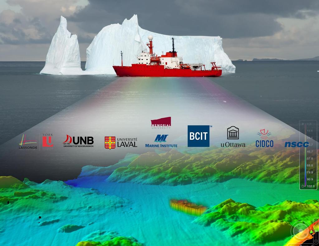
Mission of the Network
|
|
|
- Evangeline Atkinson
- 6 years ago
- Views:
Transcription
1
2
3 Mission of the Network The purpose of the COMREN is to Develop research activities, Achieve technology transfer to the Industry, Develop and run educational programs, in liaison with government agencies, increase Canada s capacity in research and education in Ocean Mapping. This includes opportunities for High Qualified Personnel (HQP) to develop their capacity in, and specialized knowledge of, ocean mapping.
4 Focus Designed to provide a collaborative environment Enhancing research activities, To share educational curriculum To address key research questions of interest to the hydrographic and ocean science community It will also be a priority for COMREN to work closely with the Canadian Hydrographic Services (CHS) and NRCan (Natural Resources Canada) to identify and engage in relevant ocean mapping activities associated with various leading-edge initiatives
5 Who are the members of COMREN and what are their capabilities?


/Bachelor of Technology IHO/FIG")


6 Fisheries and Marine Institute of Memorial University School of Ocean Technology Research Interest Ocean Mapping Fisheries Acoustic GIS Remote Sensing Geodesy Big Data Education Diploma (Ocean Mapping)/Bachelor of Technology IHO/FIG Cat B recognized. Master of Technology Management Eng. Graduate Diploma in Ocean Mapping Under development Equipment MV Enquisitor Multibeam sonar Kongsberg EM710 Sub-bottom profiler Knudsen 4 channel CHIRP Sidescan sonar Klein 3000 (100/500kHz) Scanning LIDAR Dynascan M250 Moving Vessel Profiler Rolls Royce MVP200 Deck equipment: Oceanographic winch (1,000kg pull)


7 Research Educational Capacity Equipment University of New Brunswick Department of Geodesy and Geomatics Engineering Ocean Mapping Group Ian Church Ocean Mapping Numerical Hydrodynamic Modelling Applications GNSS GIS Remote Sensing Geodesy Big Data Bachelor of Science in Geomatics Eng. Bachelor of Geomatics Master of Eng. Master of Science in Eng. Doctor of Philosophy CSL Heron EM710 Mesotech M3 EM x MVP30 Applanix POSMv Coda F185 GNSS Systems Trimble TX5 3D Laser Scanner


8 Research topics end expertise: Centre Interdisciplinaire pour le Développement de la Cartographie des Océans, Rimouski, Québec CIDCO is a non for profit organization which activity is devoted to Research, Education and Technology Transfert. Advanced MBES data processing Automatic calibration of MBES and mobile LiDAR systems Automatic methods for MBES QA/QC and performance analysis Autonomous Survey systems Special works in Hydrography CIDCO Course in Hydrographic surveying: IHO recognized Category B course, partially in e-learning
 Degree (+2yrs) (w/ prior diploma) in Geomatics - Bachelor of Technology (20 students per cohort) Aligned with CBEPS Curriculum (Canadian")
9 BCIT School of Construction & Environment Geomatics Department Educational Capacity Geomatics Department is geared towards preparing students for entry into Land Surveying Profession Diploma (2yrs) in Geomatics Engineering Technology (50 students per cohort) Degree (+2yrs) (w/ prior diploma) in Geomatics - Bachelor of Technology (20 students per cohort) Aligned with CBEPS Curriculum (Canadian Board of Examiners for Professional Surveyors) upon graduation students attain 11/13 CBEPS Certificates of Completion, allowing them to article as an LST Hydrographic Equipment (in storage sigh) We currently do not have a institute vessel (engine failed in 2014) Knudsen 320BP Dual Frequency Single Echo-Sounder Imagenex Sportscan SideScan Sonar Valeport Tide Gauge ODOM DigiBar SVP Educations Site Licenses of CARIS HIPS/SIPS - LOTS Terrascan LiDAR Tools - TSCAN/TMODEL software (BathyLiDAR compatible or Vessel Mounted Lidar)

10 Nova Scotia Community College Research Capacity - Two research groups at NSCC with a focus on ocean mapping: Applied Oceans Research Group (AORG): Dr. Craig Brown, NSERC Industrial Research Chair in Integrated Ocean Mapping Technologies Offshore mapping using integrated approaches and tools Multibeam sonar bathymetry, backscatter and water column collection and analysis Ground-truthing technologies technology development (e.g. sensors and platforms) Autonomous platforms (ASVs/AUVs) Geological, Benthic Habitat and Fisheries Resource Mapping: development and testing of GIS tools and methods Equipment: Multibeam echosounder Sidescan sonar Bathymetric LIDAR AUV Sidescan sonar 4K underwater video system ADCP etc Applied Oceans Research Group (AGRG): Dr. Tim Webster, Research Scientist Coastal Mapping Bathymetric LIDAR, areal imagery, shallow subtidal (multibeam) Coastal oceanography Various applications of technologies for coastal zone mapping. UAVs Educational Capacity : Certificates, Diplomas and Advanced Diplomas in numerous related fields: e.g Marine Geomatics Remote Sensing Ocean Technology GIS MSc Applied Geomatics (joint with Acadia University)


11 LiDAR / Multibeam / Sidescan sonar / Acoustic camera Sonar image matching & change detection Seabed mapping and classification 2D / 3D mosaic Multibeam and sonar image data fusion 3D reconstruction of underwater scenes Automatic calibration and performance analysis Hydrographic sounding based on autonomous (surface & underwater) vehicles Educational training in hydrography and marine geomatics
12 Research capacity: 3 professors in geomatics sciences + 1 professor in geography + 2 teaching & research assistants Educational capacity: 2 undergraduate programs (Land surveyor and Geomatics engineer) providing the main knowledge and competencies with respect to Category A certification in hydrography + M.SC. + PhD. Equipment: Metrology lab: Laser interferometer and calibration bench + Leica TS06 Total stations (13) + Leica Sprinter levels (13) + Topcon AT B4 levels (15) GPS lab: Trimble R8 GNSS receivers (6) Trimble TX5 LiDAR scanner + Qimera software + Marine Geoscience lab: Kongsberg Munin AUV (summer 2017) + Multibeam sonar (Kongsberg EM2040c, EM302, Odom ES3, Reson 8101) + Subsurface profiler + Sidescan sonar Klein GeoAcoustic GeoSwath + Magnetometer + Core drill
 directly useful for ocean mapping.")
13 Department of Geography, University of Ottawa. Expertise primarily in Satellite-Derived Bathymetry, mapping and monitoring Canadian Arctic glaciers. BSc, MSc, PhD... Four CFI labs with computing and field equipment (Anders Knudby, Luke Copland, Jackie Dawson, Michale Sawada) directly useful for ocean mapping. Several other ancillary CFI labs with additional equipment. Equipment single-beam sounder, several drones, hyperspectral imaging sensor. Access to a privately owned Cessna 172 based in Ottawa.

 BSc (Geomatics Sci.) MSc (Earth & Space Sci.) PhD (Earth & Space Sci.")

14 Research Interests Educational Capacity Equipment York University Department of Earth & Space Science & Engineering Geomatics Engineering / Geomatics Science Positioning / Navigation Unmanned Aerial / Surface Vehicles / Marine Systems Geodesy / Gravity / Satellite Altimetry Remote Sensing / GIS Marine Infrastructures Dense 3D Surface Reconstruction Data Analytics / Visualization Coastal Risk Mapping BEng (Geomatics Eng.) BSc (Geomatics Sci.) MSc (Earth & Space Sci.) PhD (Earth & Space Sci.) Certificate GIS & Remote Sensing CEAB Engineering Accreditation Association of Ontario Land Surveyors Accreditation Esri Canada GIS Centre of Excellence GNSS receivers GNSS simulator Geodetic equipment Autopilots UAVs CARIS HIPS and SIPS ArcGIS ERDAS Imagine PCI Geomatica Terrasolid
15 Vision Promote increased research and education capacity in Canada and to the international community. Each of its members bring unique educational opportunities and research themes to the network that will complement and enhance the programs of the individual members. Not to be cliché but the whole of the network outweighs the sum of the individual parts.

16 Paul M Brett Head School of Ocean Technology Fisheries and Marine Institute of Memorial University St. Johns NL Canada Paul.Brett@mi.mun.ca
Costas Armenakis (York University), Craig Brown (NSCC), Paul Brett (Marine Institute, Memorial University), Ian Church (UNB), Sylvie Daniel (Laval
, Craig Brown (NSCC), Paul Brett (Marine Institute, Memorial University), Ian Church (UNB), Sylvie Daniel (Laval") Costas Armenakis (York University), Craig Brown (NSCC), Paul Brett (Marine Institute, Memorial University), Ian Church (UNB), Sylvie Daniel (Laval University), Sean Galway (BCIT), Anders Knudsby (Ottawa
Costas Armenakis (York University), Craig Brown (NSCC), Paul Brett (Marine Institute, Memorial University), Ian Church (UNB), Sylvie Daniel (Laval University), Sean Galway (BCIT), Anders Knudsby (Ottawa
NOAA/University of New Hampshire Joint Hydrographic Center & Center for Coastal and Ocean Mapping. MAPPS Summer Conference July 23, 2013
 NOAA/University of New Hampshire Joint Hydrographic Center & Center for Coastal and Ocean Mapping MAPPS Summer Conference July 23, 2013 07/23/2013 2 07/23/2013 3 Center Goals To be a world leader in the
CANADIAN HYDROGRAPHIC SERVICE
 CANADIAN HYDROGRAPHIC SERVICE Surveying and Charting Canada s Waters Since 1883 Ilulisat Maritime Workshop 2017 The Importance and Need for Hydrography Denis Hains, Hydrographer General of Canada & Director
Hydrography at MSc and Category A level: a European perspective. Victor Abbott & Nicolas Seube
 Hydrography at MSc and Category A level: a European perspective Victor Abbott & Nicolas Seube La Manche A map of our localities... Plymouth University of Plymouth RNHMS Training School Plymouth Martine
National Marine Sanctuary Program
 National Marine Sanctuary Program NMSP/USGS Joint Seabed Mapping Initiative: September 2004 AA National Ocean Service National Marine Sanctuaries Interim Report September 2004 Background: Since 2002,
What is special about geospatial? or A discipline in constant transition
 What is special about geospatial? or A discipline in constant transition Marinos Kavouras NTUA Ensuring the Rapid Response to Change, Ensuring the Surveyor of Tomorrow FIG 2015 Several paradigm shifts
12/11/2013& egm502 seafloor mapping
 egm502 seafloor mapping lecture 13 multi-beam echo-sounders The majority of the current charts of the ocean floors have been produced from single beam echo-sounder data. Even though these data have been
Themes for Geomatics Conference. Geodesy Themes
 Themes for Geomatics Conference Geodesy Themes Geodynamics o Modeling the Deformation of the Earth s Crust o Recent Advances in Geometric Approaches to Deformation Analysis o Monitoring Systems (Sensors
MONITORING OF VENICE INLET CHANNELS. Sharing knowledge to make data available for everyone
 MONITORING OF VENICE INLET CHANNELS Sharing knowledge to make data available for everyone Introduction What does hydrography really mean? IHO defines hydrography as a description of the physical features
Multiple methods, maps, and management applications: purpose made maps in support of Ocean Management. Craig J. Brown McGregor GeoScience Ltd.
 Multiple methods, maps, and management applications: purpose made maps in support of Ocean Management Craig J. Brown McGregor GeoScience Ltd. International workshop on seabed mapping methods and technology,
14 th NIOHC, Myanmar National Report MYANMAR NAVAL HYDROGRAPHIC CENTRE (MNHC) NATIONAL REPORT HYDROGRAPHIC DEPARTMENT, ROYAL THAI NAVY-HDRTN
 NATIONAL REPORT HYDROGRAPHIC DEPARTMENT, ROYAL THAI NAVY-HDRTN") 14 th NIOHC, Myanmar National Report MYANMAR NAVAL HYDROGRAPHIC CENTRE (MNHC) NATIONAL REPORT 14 th NORTH INDIAN OCEAN HYDROGRAPHIC COMMISSION CONFERENCE HYDROGRAPHIC DEPARTMENT, ROYAL THAI NAVY-HDRTN
14 th NIOHC, Myanmar National Report MYANMAR NAVAL HYDROGRAPHIC CENTRE (MNHC) NATIONAL REPORT 14 th NORTH INDIAN OCEAN HYDROGRAPHIC COMMISSION CONFERENCE HYDROGRAPHIC DEPARTMENT, ROYAL THAI NAVY-HDRTN
Work Package 5: Signal Processing and Seafloor Classification
 Work Package 5: Signal Processing and Seafloor Classification Jarosław Tęgowski and Karolina Trzcińska Marine Geophysics Lab. Institute of Oceanography University of Gdańsk, Poland Kick-Off Meeting, Kiel,
XXIII CONGRESS OF ISPRS RESOLUTIONS
 XXIII CONGRESS OF ISPRS RESOLUTIONS General Resolutions Resolution 0: Thanks to the Czech Society commends: To congratulate The Czech Society, its president and the Congress Director Lena Halounová, the
DAVID L. COLVILLE. Education
 DAVID L. COLVILLE Applied Geomatics Research Group (AGRG) Centre of Geographic Sciences (COGS) Annapolis Valley Campus, NSCC Middleton, Nova Scotia, Canada B0S 1P0 Phone: (902) 825 5476 Fax: (902) 825-5479
Use of a nested finite-element hydrodynamic model to predict phase and amplitude modification of tide within narrow fjords
 Use of a nested finite-element hydrodynamic model to predict phase and amplitude modification of tide within narrow fjords Ian Church, John E. Hughes Clarke and Susan Haigh Dept. Geodesy and Geomatics
enny Mills chool of Civil ngineering & eosciences ewcastle University
 Future of Surveying: Educating the future geospatial expert A Newcastle University perspective enny Mills chool of Civil ngineering & eosciences ewcastle University Future of surveying: Do we still need
Mapping and monitoring sedimentary processes and fluxes across fjord deltas - Baffin Island
 Mapping and monitoring sedimentary processes and fluxes across fjord deltas - Baffin Island John E. Hughes Clarke, Steve Brucker, Auke van der Werfe, Ian Church and Kashka Iwanowska Ocean Mapping Group,
Excel Geomatics: Offering Excellence with Unique Consultancy & Services
 Excel Geomatics: Offering Excellence with Unique Consultancy & Services Providing consultancy and value Added Services using Remote Sensing, Photogrammetry and LiDAR in areas such as Agriculture, Forestry,
The courses presently offered in the Geomatics Engineering Program by the Department of Geodesy and Geomatics Engineering are described below.
 GGE GEODESY AND GEOMATICS ENGINEERING The courses presently offered in the Geomatics Engineering Program by the Department of Geodesy and Geomatics Engineering are described below. The first digit of the
GEOMATICS. Shaping our world. A company of
 GEOMATICS Shaping our world A company of OUR EXPERTISE Geomatics Geomatics plays a mayor role in hydropower, land and water resources, urban development, transport & mobility, renewable energy, and infrastructure
Automated Seabed Mapping and Data Delivery in the Cloud
 Automated Seabed Mapping and Data Delivery in the Cloud London, 2nd November 2017 11/20/2017 1 2 WE CALL IT SEABED INTELLIGENCE Ocean Infinity are explorers. We go to unmapped locations to survey the seabed
Autonomous Platforms for Marine Mapping and Monitoring: A UK Perspective. Dr Russell B Wynn (Head of NOC Marine Geoscience, MARS Chief Scientist)
") Autonomous Platforms for Marine Mapping and Monitoring: A UK Perspective Dr Russell B Wynn (Head of NOC Marine Geoscience, MARS Chief Scientist) Marine mapping and monitoring: an escalating problem. Policy
Autonomous Platforms for Marine Mapping and Monitoring: A UK Perspective Dr Russell B Wynn (Head of NOC Marine Geoscience, MARS Chief Scientist) Marine mapping and monitoring: an escalating problem. Policy
COMPARATIVE STUDY BETWEEN FLAT AND UNIFORM BOTTOM ASSUMPTIONS FOR SNIPPET IMAGERIES IN HYDROGRAPHIC APPLICATIONS
 COMPARATIVE STUDY BETWEEN FLAT AND UNIFORM BOTTOM ASSUMPTIONS FOR SNIPPET IMAGERIES IN HYDROGRAPHIC APPLICATIONS Rubasingam R., Mahmud M.R. and Gunathilaka M.D.E.K. Hydrographic Research and Training Office,
Tools to Assess Flood Risk of Commercial Property Investment
 Tools to Assess Flood Risk of Commercial Property Investment NSERC Workshop March 1, 2016 Kate Collins, Tim Webster, Nathan Crowell AGRG, NSCC, Middleton, NS https://eatsleepride.com/ http://users.eastlink.ca/~tbulley/
WHAT YOU WILL LEARN TODAY
 WHAT YOU WILL LEARN TODAY Overview of the new QGIS Academy Curriculum Background on curriculum development Curriculum alignment with national standards Description of the five GIS courses Details of the
Bachelor of Geospatial Science The University of the South Pacific
 Bachelor of Geospatial Science The University of the South Pacific Geospatial Science Unit School of Geography, Earth Science and Environment Aleen Elisha Prasad Inesha Manzini Semisi Ketenilagi Geospatial
Introduction to Acoustic Remote Sensing and Seafloor Mapping (AE4-E13) May 19, 2010
 May 19, 2010") Introduction to Acoustic Remote Sensing and Seafloor Mapping (AE4-E13) May 19, 2010 1 Delft Vermelding Institute onderdeel of Earth organisatie Observation and Space Systems Why Acoustic Remote Sensing?
Introduction to Acoustic Remote Sensing and Seafloor Mapping (AE4-E13) May 19, 2010 1 Delft Vermelding Institute onderdeel of Earth organisatie Observation and Space Systems Why Acoustic Remote Sensing?
Kyle Griebel NRS 509 Dr. August & Dr. Wang GIS and remote sensing in Seafloor mapping
 GIS and remote sensing in Seafloor mapping Introduction to seafloor mapping Seafloor maps have a wide variety of uses for scientists and coastal planning needs. Some of these uses include biological assessment
Different Models of the Curriculum for the Higher Education of Surveying & Mapping in China
 Different Models of the Curriculum for the Higher Education of Surveying & Mapping in China NING Jinsheng, LIU Yanfang, LIU Yaolin, China P. R. Key words: curriculum, common foundation, distinguished feature
Geospatial Policy Development and Institutional Arrangements *
 HIGH LEVEL FORUM ON GLOBAL GEOSPATIAL MANAGEMENT INFORMATION WORKING PAPER No. 13 First Forum Seoul, Republic of Korea, 24-26 October 2011 Geospatial Policy Development and Institutional Arrangements *
The 1st International Hydrographic Summer Camp 2007 in Germany. Volker Böder
 T2F Young Surveyors (2967) The 1st International Hydrographic Summer Camp 2007 in Germany Volker Böder Integrating the Generations FIG Working Week 2008 Stockholm, Sweden 14-19 June 2008 Motivation Missing
ON THE ROAD JULY/AUGUST MAP PROJECTIONS The importance of horizontal and vertical datums in GIS mapping
 VOLUME 4 ISSUE 5 JULY/AUGUST 2014 ON THE ROAD 30 40 62 MAP PROJECTIONS The importance of horizontal and vertical datums in GIS mapping FOLLOW THE LEDDAR A special purpose sensor that does several 3D measurement
BCIT Geomatics Report
 BCIT Geomatics Report ABCLS AGM 2006 School of Construction and The Environment Contents Geomatics Department Overview Faculty/Students Statistics Geomatics Programs/Options Full-Time Programs Diploma:
River bed classification using multi-beam echo-sounder backscatter data. Niels KINNEGING Rijkswaterstaat Centre for Water Management
 River bed classification using multi-beam echo-sounder backscatter data Niels KINNEGING Rijkswaterstaat Centre for Water Management Mirjam SNELLEN Delft University of Techonology Dimitrios ELEFTHERAKIS
WHAT YOU WILL LEARN TODAY
 WHAT YOU WILL LEARN TODAY Overview of the new GeoAcademy Curriculum Background on curriculum development Curriculum alignment with national standards Description of the five GIS courses Details of the
Seamless Online Distribution of Amundsen Multibeam Data
 Seamless Online Distribution of Amundsen Multibeam Data J. Muggah 1, I. Church 1, J. Beaudoin 1 and J. Hughes Clarke 1 1 Ocean Mapping Group, University of New Brunswick. Abstract Since 2003, all underway
Europass Curriculum Vitae
 Europass Curriculum Vitae Personal information First name(s) / Surname(s) Clinci Tudorel Silviu Address Valea Doftanei, Prahova county, 107640, Romania E-mail(s) tudorelsilviu@yahoo.com Nationality Romanian
The B.S.G.E. program is accredited by the Engineering Accreditation Commission of ABET,
 Geomatics Engineering The program of study leading to the Bachelor of Science in Geomatics Engineering (B.S.G.E.) deals with designing solutions to measure, map, model, analyze and graphically display
H.A.R.S. PRA #1 (Historic Area Remediation Site)
") H.A.R.S. PRA #1 (Historic Area Remediation Site) 2009 Multibeam Bathymetry TABLE OF CONTENTS Page LIST OF TABLES 2 LIST OF FIGURES 3 1.0 INTRODUCTION 4 2.0 OBJECTIVE 4 3.0 PROCEDURE 4 3.1 DATA ACQUISITION
H.A.R.S. PRA #1 (Historic Area Remediation Site) 2009 Multibeam Bathymetry TABLE OF CONTENTS Page LIST OF TABLES 2 LIST OF FIGURES 3 1.0 INTRODUCTION 4 2.0 OBJECTIVE 4 3.0 PROCEDURE 4 3.1 DATA ACQUISITION
Offshore Operations and Project Execution Geophysical Site Surveys
 Offshore Operations and Project Execution Geophysical Site Surveys Chris Almond Senior Geophysicist Fugro Survey Limited 22/04/2015 Presentation Summary: Office-based Personnel Project Awarded Pre Offshore
Earth Sciences at the University of Windsor.
 Earth Sciences at the University of Windsor http://www.uwindsor.ca/earth Earth Sciences is:! Geology! Physical Geography! The Environment Our Degree Programs! B.Sc. Geology*! B.Sc. Environmental Geoscience*!
Field and Numerical Study of the Columbia River Mouth
 DISTRIBUTION STATEMENT A. Approved for public release; distribution is unlimited. Field and Numerical Study of the Columbia River Mouth Guy Gelfenbaum 400 Natural Bridges Dr. Santa Cruz, CA 95060 Phone:
CSL HERON MAPPING OPERATIONS, MAY 23 RD -JUNE 4 TH BLUE HILL BAY, MAINE, USA OCEAN MAPPING GROUP CRUISE REPORT JAMES MUGGAH AND TRAVIS HAMILTON
 CSL HERON MAPPING OPERATIONS, MAY 23 RD -JUNE 4 TH BLUE HILL BAY, MAINE, USA OCEAN MAPPING GROUP CRUISE REPORT JAMES MUGGAH AND TRAVIS HAMILTON SPRING 2009 / NOVEMBER 2009 OCEAN MAPPING GROUP UNIVERSITY
NEW SEAFLOOR INSTALLATIONS REQUIRE ULTRA-HIGH RESOLUTION SURVEYS
 NEW SEAFLOOR INSTALLATIONS REQUIRE ULTRA-HIGH RESOLUTION SURVEYS Donald Hussong (Fugro Seafloor Surveys, Inc.) dhussong@fugro.com Fugro Seafloor Surveys, Inc., 1100 Dexter Avenue North (Suite 100), Seattle,
Recent developments in multi-beam echo-sounder processing at the Delft
 Recent developments in multi-beam echo-sounder processing at the Delft University of Technology Prof. Dr. Dick G. Simons Acoustic Remote Sensing Group, Faculty of Aerospace Engineering, Delft University
Modelling the estuarine circulation of the Port of Saint John: Visualizing complex sound speed distribution.
 Modelling the estuarine circulation of the Port of Saint John: Visualizing complex sound speed distribution. Ian CHURCH, John HUGHES CLARKE, Susan HAIGH and Reenu TOODESH, Canada Key words: Hydrodynamic
Geophysical Site Surveys
 Geophysical Site Surveys Simon Oakley Geoscience Team Leader Fugro Survey Limited 16/04/2014 Contents Menu Introduction Section 1 - Geophysical Site Surveys - Seabed Bathymetry - Shallow Geology - Seabed
THE NEW CHALLENGES FOR THE HIGHER EDUCATION OF GEODESY IN UACEG SOFIA
 THE NEW CHALLENGES FOR THE HIGHER EDUCATION OF GEODESY IN UACEG SOFIA Ivan Kunchev University of Architecture, Civil Engineering and Geodesy, 1 Hristo Smirnenski Blvd., Sofia 1046, Bulgaria Abstract Report
What can I do with a major in Earth Information Science?
 Lewis-Clark State College offers a Bachelor of Arts or Science Degree in Earth Information Science through the Natural Sciences and Mathematics Division. You can learn more about the Natural Sciences and
Islands beaches & Coral reefs
 Islands beaches & Coral reefs water solutions Since 2005 www.water-solutions.biz ABOUT US Water Solutions Established in 2005, we are one of the leading environmental and surveying companies in the Maldives
Canadian Coastal Lidar Mapping Initiatives in Support of the Ocean Protection Plan
 Canadian Coastal Lidar Mapping Initiatives in Support of the Ocean Protection Plan Stephen Parsons Canadian Hydrographic Service Bedford Institute of Oceanography Dartmouth, Nova Scotia stephen.parsons@dfo-mpo.gc.ca
FINMARINET: Inventories and Planning for the Marine Natura 2000 Network in Finland. A.2 Geological inventories of the seafloor Final Report
 LIFE07 NAT/FIN/000151 FINMARINET: Inventories and Planning for the Marine Natura 2000 Network in Finland A.2 Geological inventories of the seafloor Final Report Geological Survey of Finland, GTK 1. Introduction
Surveyors, Cartographers, Photogrammetrists, and Surveying and Mapping Technicians
 http://www.bls.gov/oco/ocos040.htm Surveyors, Cartographers, Photogrammetrists, and Surveying and Mapping Technicians * Nature of the Work * Training, Other Qualifications, and Advancement * Employment
DINGLE FISHERY HARBOUR CENTRE COUNTY KERRY BATHYMETRIC AND GEOPHYSICAL SURVEY. September 2016 REPORT
 Doc. Ref. 1253-16-1 DINGLE FISHERY HARBOUR CENTRE COUNTY KERRY BATHYMETRIC AND GEOPHYSICAL SURVEY September 2016 REPORT Client: Report by: Marine engineering Division Blennerville Tralee, Co. Kerry Irish
Data and Information Management. UK All Energy 22 nd May Presented by Leo James
 Data and Information Management UK All Energy 22 nd May 2013 Presented by Leo James Strategic Development Plans Observations at the outset Data and information management and dissemination: company or
Land Administration and Cadastre
 Geomatics play a major role in hydropower, land and water resources and other infrastructure projects. Lahmeyer International s (LI) worldwide projects require a wide range of approaches to the integration
Arctic Observing Systems Challenges, New opportunities and Integration
 Arctic Observing Systems Challenges, New opportunities and Integration Japan Norway Arctic Science Week 03 June 2016 By Stein Sandven, NERSC Building an integrated Arctic Observing System Need to collect,
NATIONAL HYDROGRAPHIC OFFICE
 NATIONAL HYDROGRAPHIC OFFICE OF SRI LANKA NATIONAL REPORT TO THE 18 TH NORTH INDIAN OCEAN HYDROGRAPHIC COMMISSION GOA, INDIA (9-12 APRIL 2018) CONTENTS 1. Introduction 03 2. Surveys 03 3. New Charts and
Open Geospatial Consortium activities in the Maritime domain
 Open Geospatial Consortium activities in the Maritime domain Scott Simmons Executive Director, Standards Program General Maritime efforts participants Alliance partners IHO ISO / TC 211 Members Danish
surr1ch H Y D R 0 G R A P H I C S Capability Statelllent
 H Y D R 0 G R A P H I C S Capability Statelllent 2015 Company Profile Surrich Hydrographics provides Level 1 Certified Hydrographic Services and Geophysical Services for activities including navigational
Proposal for Revision to the Geographic Information Systems (GIS) Academic Certificate Community College of Philadelphia.
 Academic Certificate Community College of Philadelphia.") Proposal for Revision to the Geographic Information Systems (GIS) Academic Certificate Community College of Philadelphia February 24, 2010 Kathy Smith Chair, Social Science Contributors Christopher Murphy
Proposal for Revision to the Geographic Information Systems (GIS) Academic Certificate Community College of Philadelphia February 24, 2010 Kathy Smith Chair, Social Science Contributors Christopher Murphy
Geodesy. orientation. shape. gravity field
 Geodesy noun Science of measuring the shape, orientation and gravity field of the Earth and how it changes over time. shape orientation gravity field Positioning has always been important Downstream applications
S/He reports to the Programme Effectiveness Manager. Lead, review and process the development of NO GIS framework and tools.
 GIS Coordinator Location: [Africa] [Ghana] Town/City: Accra Category: Knowledge Management GIS Coordinator To provide leadership and management to cluster staff (of 2 to 3 Area Programs) by ensuring that
This report addresses the Arctic-related activities of the Canadian Hydrographic Service since last ARHC meeting.
 ARHC4-2.1 Canadian Hydrographic Service Report to the 4th meeting of the Arctic Regional Hydrographic Commission January 29-30, 2014 Portsmouth, New Hampshire, USA This report addresses the Arctic-related
An Overview of Geomatics Involvement in the Offshore Oil & Gas Industry
 An Overview of Geomatics Involvement in the Offshore Oil & Gas Industry David Whitcombe Head Offshore Surveys - Europe Explore Appraise Develop ProduceDecommission Content Overview Oil & Gas Industry Geomatics
Inspire Conference Istanbul, 2012 Ralf Lindgren. Inspire Conference Istanbul, 2012 Ralf Lindgren
 Background A Baltic Sea Bathymetry Database Concept and Hans Öiås Swedish Maritime Administration Hydrographic Office A national directive: The Swedish Maritime Administration shall, in cooperation with
Joint Hydrographic Center, National Oceanic and Atmospheric Administration, Durham, NH 03824, USA
 Future directions in hydrography using satellite-derived bathymetry Shachak Pe eri 1, Christopher Parrish 2, 3, Lee Alexander 1, Chukwuma Azuike 1, Andrew Armstrong 1,3 and Maryellen Sault 2 1 Center for
Acoustic seafloor mapping systems. September 14, 2010
 Acoustic seafloor mapping systems September 14, 010 1 Delft Vermelding Institute onderdeel of Earth organisatie Observation and Space Systems Acoustic seafloor mapping techniques Single-beam echosounder
Current Hydrographic Projects at BSH
 7 th Workshop Seabed Acoustics, Rostock, November 19/20, 2015 P01-1 Current Hydrographic Projects at BSH Thomas Dehling Federal Maritime and Hydrographic Agency (BSH) Germany Contact Address Website BSH
GIS Visualization: A Library s Pursuit Towards Creative and Innovative Research
 GIS Visualization: A Library s Pursuit Towards Creative and Innovative Research Justin B. Sorensen J. Willard Marriott Library University of Utah justin.sorensen@utah.edu Abstract As emerging technologies
R E P U B L I C O F C Y P R U S. NATIONAL REPORT OF CYPRUS TO THE 19 th MEDITERRANEAN AND BLACK SEAS HYDROGRAPHIC COMMISSION (MBSHC)
") R E P U B L I C O F C Y P R U S NATIONAL REPORT OF CYPRUS TO THE 19 th MEDITERRANEAN AND BLACK SEAS HYDROGRAPHIC COMMISSION (MBSHC) BATUMI MEETING 30 JUNE TO 02 JULY 2015 NATIONAL REPORT OF CYPRUS TO THE
R E P U B L I C O F C Y P R U S NATIONAL REPORT OF CYPRUS TO THE 19 th MEDITERRANEAN AND BLACK SEAS HYDROGRAPHIC COMMISSION (MBSHC) BATUMI MEETING 30 JUNE TO 02 JULY 2015 NATIONAL REPORT OF CYPRUS TO THE
The Arctic - A New Frontier The geological, environmental and engineering challenges for submarine telecommunication cables
 The Arctic - A New Frontier The geological, environmental and engineering challenges for submarine telecommunication cables Ryan Wopschall 5 September 2013 Oceanology International China, Shanghai Fugro
Byblos & the Sea - an HFF funded project Summary report: Sea Survey Mission 7 - Sept. 2016
 Byblos & the Sea - an HFF funded project Summary report: Sea Survey Mission 7 - Sept. 2016 In the framework of the research program Byblos and the Sea a marine remote sensing and sampling survey was carried
MID-TERM CONFERENCE CREST
 MID-TERM CONFERENCE CREST 23 November 2017 Innovation in Coastal Monitoring Alain De Wulf (Ugent, Geography Dept.) Innovation in coastal monitoring Outline Why? How? What (tools do we use to assess)? Conclusion
Inspection of Waterfront Facilities Using Vessel-Based Remote Sensing Mitchell, Del Bello, Suarez
 Inspection of Waterfront Facilities Using Vessel-Based Remote Sensing Mitchell, Del Bello, Suarez American Association of Port Authorities Facilities Engineering Conference October 20-22, 2015 Waterfront
Qualitative Spatio-Temporal Reasoning & Spatial Database Design
 Qualitative Spatio-Temporal Reasoning Focus on 2 research topics at the of the University of Liège J-P. Donnay P. Hallot F. Laplanche Curriculum in «Surveying & Geomatics» in the Faculty of Sciences of
SEABED CLASSIFICATION FROM MULTIBEAM ECHOSOUNDER BACKSCATTER DATA USING WAVELET TRANSFORMATION AND NEURAL NETWORK APPROACH
 SEABED CLASSIFICATION FROM MULTIBEAM ECHOSOUNDER BACKSCATTER DATA USING WAVELET TRANSFORMATION AND NEURAL NETWORK APPROACH Jaroslaw Tegowski a,b, Jaroslaw Nowak a, Mateusz Moskalik c, Kazimierz Szefler
Regional GIS Initiatives Geospatial Technology Center
 Regional GIS Initiatives Geospatial Technology Center Mr. Bobby Lear GIS Coordinator St. James Parish & Dr. Balaji Ramachandran Contractors Educational Trust Fund Endowed Professor Geomatics Program, Department
Integrating Environmental and Geomatics Technologies for Landscape Monitoring, Assessment and Restoration
 Integrating Environmental and Geomatics Technologies for Landscape Monitoring, Assessment and Restoration Applied Geomatics Research Group (AGRG) Centre of Geographics Sciences (COGS) NSCC Annapolis Valley
GIS Workshop Data Collection Techniques
 GIS Workshop Data Collection Techniques NOFNEC Conference 2016 Presented by: Matawa First Nations Management Jennifer Duncan and Charlene Wagenaar, Geomatics Technicians, Four Rivers Department QA #: FRG
The XXIV FIG International Congress April 2010, Sydney, Australia
 Impact of TEMPUS CARDS Project GIST- CroHE on the new MSc in Geoinformatics Curriculum and on the Implementation of Bologna Process at the Faculty of Geodesy, University of Zagreb, Croatia Damir Medak,
STATISTICAL ANALYSIS FOR AUTOMATED SEEP EXTRACTION IN GIS
 STATISTICAL ANALYSIS FOR AUTOMATED SEEP EXTRACTION IN GIS Presented by Pamela Kanu, GISP ESRI USER CONFERENCE JULY 2017 SEEPS Seeps are natural gas and crude oil that enter the ocean through cracks and
CONTENT. 2 Subject Aims 2. 6 Assessment Strategies 5. 7 Maintaining Standards 5. 9 Annexes 8
 CONTENT Page No Foreword III 1 Introduction 1 1.1 Subject Benchmark statement 1 1.2 Nature and Extent of the Subject 2 2 Subject Aims 2 3 Subject Knowledge and Understanding 3 4 Skills and Attitudes 4
USING LANDSAT IN A GIS WORLD
 USING LANDSAT IN A GIS WORLD RACHEL MK HEADLEY; PHD, PMP STEM LIAISON, ACADEMIC AFFAIRS BLACK HILLS STATE UNIVERSITY This material is based upon work supported by the National Science Foundation under
The courses presently offered in the Geomatics Engineering Program by the Department of Geodesy and Geomatics Engineering are described below.
 GGE GEODESY AND GEOMATICS ENGINEERING The courses presently offered in the Geomatics Engineering Program by the Department of Geodesy and Geomatics Engineering are described below. The first digit of the
A century in Surveying Education. The recruitment challenge in the 2000 s
 Bridging the gap between academic, governement and private sectors to recruit the next generations of Land Surveyors & Geomatics Engineers A success story in Québec, Canada Annick Jaton Communication presented
Department of Geosciences. Geology Meteorology Oceanography
 Department of Geosciences Geology Meteorology Oceanography Geoscientists study the earth Rivers Soils Lake sediments Evidence of ancient oceans Maps Volcanoes Fence offset by San Andreas fault Water quality
Technical Drafting, Geographic Information Systems and Computer- Based Cartography
 Technical Drafting, Geographic Information Systems and Computer- Based Cartography Project-Specific and Regional Resource Mapping Services Geographic Information Systems - Spatial Analysis Terrestrial
Benthic habitat mapping using multibeam sonar
 Benthic habitat mapping using multibeam sonar Iain M. Parnum 1, Alexander Gavrilov 1 and Justy Siwabessy 2 1. Centre for Marine Science and Technology, Curtin University, Perth, Australia 2. Geoscience
Backscatter and Seafloor Acoustical Properties of Wellington Harbour; Preliminary Results and Potential
 Backscatter and Seafloor Acoustical Properties of Wellington Harbour; Preliminary Results and Potential Geoffroy Lamarche 1, Xavier Lurton 2, Jean-Marie Augustin 2, Anne- Laure Verdier 1 and Arne Pallentin
CHAPTER 6 RESULTS FIGURE 8.- DATA WORK FLOW FOR BACKSCATTER PROCESSING IN HYPACK
 CHAPTER 6 RESULTS 6.1. Backscatter Workflow Comparison Currently, INOCAR owns and operates RESON and Kongsberg multibeam systems for nearshore surveys. The RESON system is integrated with HYPACK Hysweep
Jun Cheng School of Geosciences, University of South Florida 4202 E. Fowler Ave., NES 117, Tampa, FL 33620
 EDUCATION Jun Cheng 4202 E. Fowler Ave., NES 117, Tampa, FL 33620 Phone: 813-974-2759 Email: jun@mail.usf.ed University of South Florida (Tampa, FL) Ph.D. in Geology, 2015 Dissertation: Multiple Scale
Remote Sensing and EO activities at the University of Turku
 Remote Sensing and EO activities at the University of Turku Niina Käyhkö Associate Professor Department of Geography and Geology GEO meeting/syke May 23rd, 2018 Geospatial competence at the University
Joanne N. Halls, PhD Dept. of Geography & Geology David Kirk Information Technology Services
 Joanne N. Halls, PhD Dept. of Geography & Geology David Kirk Information Technology Services Geographic Information Systems manage and analyze data to solve spatial problems. Real World Abstraction Analysis
Grade 11 Student Electives Guidelines for 2015/16
 Grade 11 Student Guidelines for 2015/16 Overview As part of Abu Dhabi Education Council s continuous improvements efforts towards raising the standard of education in the Emirate of Abu Dhabi, the Cycle
Indonesia Frontier Basin SUNDA (SU-08) NON-EXCLUSIVE 2-D SURVEY 3084km
 NON-EXCLUSIVE 2-D SURVEY 3084km") Indonesia Frontier Basin SUNDA (SU-08) NON-EXCLUSIVE 2-D SURVEY 3084km SEISMIC ACQUISITION PARAMETERS Acquisition Date: January - March 2008 Vessel: M/V Osprey Explorer Shooting Orientation: Strike-Dip
Indonesia Frontier Basin SUNDA (SU-08) NON-EXCLUSIVE 2-D SURVEY 3084km SEISMIC ACQUISITION PARAMETERS Acquisition Date: January - March 2008 Vessel: M/V Osprey Explorer Shooting Orientation: Strike-Dip
Capacity Building Activities at CRECTEALC. Ing. Jerjes Molina Blancas Professor and Developer.
 Capacity Building Activities at CRECTEALC Ing. Jerjes Molina Blancas Professor and Developer. Centro Regional de Enseñanza de Ciencia y Tecnología del Espacio para América Latina y el Caribe (CRECTEALC)
REPORT BY THE HYDROGRAPHIC AND GEODETIC SERVICE OF THE REPUBLIC OF CUBA. 18 th MESO AMERICAN AND CARIBBEAN SEA HYDROGRAPHIC COMMISSION MEETING
 REPORT BY THE HYDROGRAPHIC AND GEODETIC SERVICE OF THE REPUBLIC OF CUBA 18 th MESO AMERICAN AND CARIBBEAN SEA HYDROGRAPHIC COMMISSION MEETING 1. STRUCTURE OF THE HYDROGRAPHIC AND GEODETIC SERVICE OF THE
Yrd. Doç. Dr. Saygın ABDİKAN Öğretim Yılı Güz Dönemi
 Yabancı Dil III (YDL285) Introduction to Geomatics Yrd. Doç. Dr. Saygın ABDİKAN 2017-2018 Öğretim Yılı Güz Dönemi 1 géomatique Geo (Earth) + informatics Geodesy + Geoinformatics Geomatics: The mathematics
LEHMAN COLLEGE OF THE CITY UNIVERSITY OF NEW YORK. 1. Type of Change: Change in Degree Requirements
 Alpha Number: Hegis Code 1214 Program Code: 30600 1. Type of Change: Change in Degree Requirements 2. From: [The curriculum consists of 45 graduate credits and includes core courses, an area of specialization,