Qualitative Spatio-Temporal Reasoning & Spatial Database Design
|
|
|
- Samson Bradford
- 5 years ago
- Views:
Transcription
1 Qualitative Spatio-Temporal Reasoning Focus on 2 research topics at the of the University of Liège J-P. Donnay P. Hallot F. Laplanche
2 Curriculum in «Surveying & Geomatics» in the Faculty of Sciences of the University of Liège Only education programme devoted to this field in the French-speaking Belgian Universities! Any other Bac. Degree in Sciences or Engineering Common 1st year Bachelor Degree in Geographical Sciences 2d year Geography Surveying & Geomatics 3d year Geography Surveying & Geomatics 1st year 2d year Master Degree in Applied Geomatics Master Degree in Applied Geomatics Master Degree in Surveying & Geomatics Master Degree in Surveying & Geomatics Other Master Degrees in Sciences or Engineering Doctorate Degree in Sciences 1


3 International Education Networks Master Degree in Applied Geomatics Master Degree in Surveying & Geomatics Sherbrooke Montpellier Laval Paris Le Mans - Strasbourg 2
4 The Chairs and shared research domains Geodesy Photogrammetr y GNSS Staff Topography Remote Sensing Cartography Spatial Analysis GIS Professors: 5 Prof. Assistant (Dr): 1 Researchers - Assistants (PhD Students): 7 Researchers: 5 Tech/Admin: 2 3
5 Typical applied researches Federal & Regional Agencies GIS design & reengineering See Poster 1 Distributed GISystem based on network technology RTK GPS network assessment «Crime mapping» & «Geographic profiling» Academic subcontracting, Local Authorities & Private Companies Web GIS development Maps and Atlas design and production International projects Geodesy & mathematical cartography (border conflicts) GIS & SDI design 4
6 Examples of fundamental research topics GNSS See poster 2 Ionosphere Modelling for GALILEO Single-Frequency Users Satellite photogrammetry See poster 3 DTM extraction and validation from SPOT 5 satellite imagery Qualitative spatial reasoning Spatio-temporal reasoning: Lecture 1 GIS design Open Source Spatial Database Design: Lecture 2 5
7 Qualitative Spatio-Temporal Reasoning Research on a generalized spatio-temporal reasoning model J-P. Donnay P. Hallot F. Laplanche
8 Outlines Introduction Life-lines representation Research objectives Spatial states Spatio-temporal configurations 7
9 Qualitative spatio-temporal reasoning Growth of dynamics data acquisition systems (on-board GPS, RFID-tags, Wi-Fi, ) Huge quantity of spatio-temporal data Necessity to develop spatio-temporal reasoning model to extract information Several ways to develop spatio-temporal reasoning model : Combining a spatial and a temporal logic Create a mereotopology from the analysis of spatio-temporal histories Users expects simple systems, useful and easily integrated 8

10 9
11 Time The wolf eats the red rabbit. Intersection between the ST histories Space Space 10
12 Spatio-temporal situation Primitive Space Qualitative Spatio-Temporal Reasoning Moving points in a 1D space time No topological intersection between the two life-lines (blue and grey) -> No ST meeting 1D spatial space space Topological touch between the two life-lines (red and grey) -> ST meeting 11
13 General research objectives The underlying idea of this research is to extract spatio-temporal information by applying topological calculi on the lifelines. Research s steps of PhD : Construct an exhaustive set of ST configurations mixing topological relationships and Allen s time intervals. Develop a ST model based on topological calculi. Study the relevance of such a model / generalisation. 12
14 Degenerated Topological topological relationships relationships Disjoint Equal Not A Not B Not A and Not B «d» «e» «A» «B» «A B» To fully encompass the ST information complexity, we propose 3 degenerated topological relationships between points. 13


15 Degenerated topological relationships A «state» is a particular relationships between objects at a given time. JEPD set of relationships: 14
16 e e d e A e e d e B A e d e A A e d e B B e d e B A e e d e A B e e d e B ST configurations of level 3 with continuity A δ A A e e d e A δ A A e e A δ A A A δ A A e d e d e A A δ A A A δ A A Number of spatio-temporal configurations d d A δ A A A δ A A e d e B A δ A A A A with continuity δ A assumption δ A : A A - 1 Level 2 : Level 3 : 36 d e e A d e e B Level 4 : 159 Level 5 : 507 Level 6 : 1363 δ A δ A without continuity assumption : A A Level 2 : 26 e e d Level e e A 3 : e e B 126 e d e Level 4 : 626 Level 5 : 3126 Level 6 : A δ A A A δ A A A δ A A - 1 Exhaustive 1 1 A - 1 1list 1 available A at A δ A A A e e A A δ A A A δ A A A e e B A δ A A d e d A δ A A A δ A A Topological relationships between lines d e A A δ A A B e e B A δ A A d e B A δ A A


17 Conclusion and further research Check if generalisation of ST configurations provides enough ST meaning to perform ST analyses. Robot navigation Behaviour monitoring B δb B - A δa A Extend model to higher spatial dimensions and extend to moving regions or bodies. Crime mapping Check possible integration / combination with others ST models Epidemiology Vehicle monitoring and management B δb B - A δa A


18 Ternary projective relationships model Clementini E. & Billen R Modeling and Computing Ternary Projective Relations Between Regions, IEEE Transactions on Knowledge and Data Engineering, 18 (6), pp Qualitative spatial reasoning Binary projective relationships model Billen R., Zlatanova S., Mathonet P. & Boniver F The Dimensional Model: a framework to distinguish spatial relationships. in D.Richardson & P. Van Oosterom (Ed.), Advances in Spatial Data Handling. Berlin Heidelberg, Springer-Verlag, pp
19 Spatial Database Design Web2GIS: a spatial database conception environment J-P. Donnay P. Hallot F. Laplanche
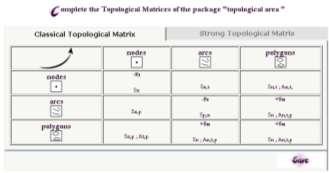
20 Web2GIS Realized in the framework of a PhD defended on September 8th 2006 Assessment: Integrated tools for Spatial Databases conception stay essentially proprietary High cost Lack of standardization Solution : Using Open Source software implementing well-known standards Some problems still penalize Open Source solutions: Maintenance and compatibility problems due to fast update Lack of user-friendly interfaces Lack of technical support 19
21 Web2GIS Our original solution: Web2GIS Spatial database conception environment centralized on a web server No need of particular tools on client, just a web browser Adapted to a large panel of users Spatial data producers, spatial database designers, spatial data users Giving priority to Open Source products and international standards Apache, Php, PostGIS, MapServer ISO/TC 211 (19 1..), OGC In the philosophy of WEB 2.0 «Web 2.0 is the business revolution in the computer industry caused by the move to the internet as platform» 20

22 The 5 modules of Web2GIS 21
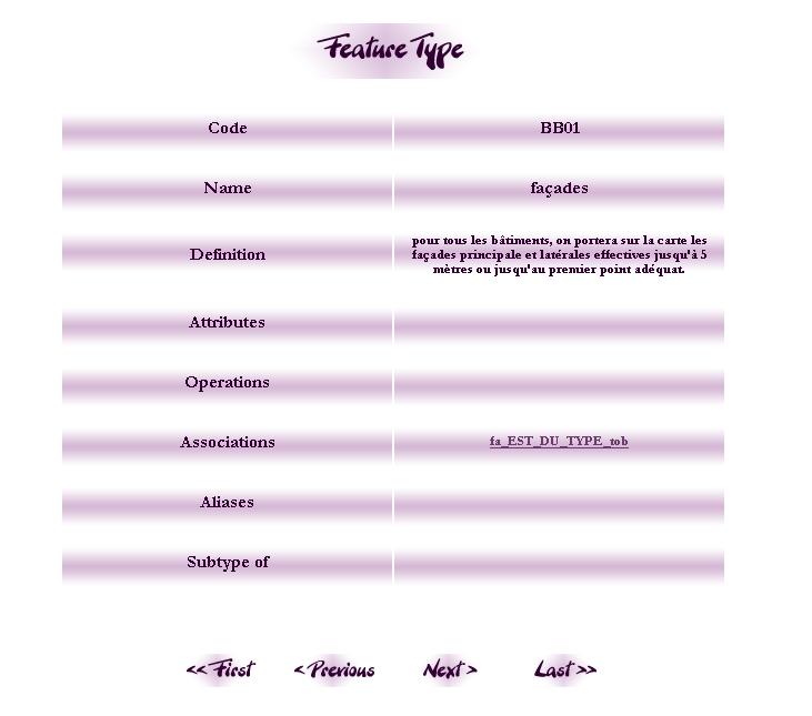
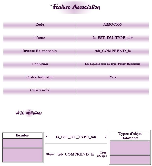
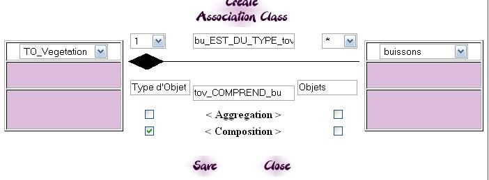
23 Web2GIS Feature Cataloguing Module Goal: Generate Feature Catalogues for data producer communities whishing to describe their specifications ISO/TC : Methodology for feature cataloguing Metabase model is inherited from the norm More important purpose than just a textual description Reflection on the concept of object UML design of associations Reflection on the concept of cardinality Possibility to reuse associations during conceptual modelling 22

24 23
25 24
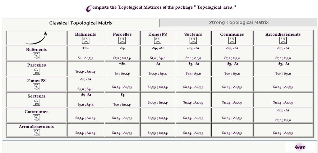
26 Web2GIS Conceptual Modelling Module Goal: Offering to the user a conceptual data model generator enabling to deal with specific applications from scratch or from one or several Feature Catalogues UML has been chosen as formalism It s based on a metamodel expressed in UML UML can be extended Metabase model is based on UML metamodel and spatio-temporal extensions ISO (Rules for application schema) and (Spatial schema) Topological constraints based on (enriched) CONGOO concepts 25


27 Concepts taken into account thanks to the notion of package 26
28 27
29 Web2GIS Spatial Databases Implementation module Goal: Allowing to generate the schema of a spatial database from one or several UML models and to load data into the tables of this database The «Case tool» part of Web2GIS Automatic generation of spatial databases Data Loading Spatial data: Shapefiles Text files (geometry column in WKT) Non spatial data: Text files 28

30 Implementation module 29


31 Data loading in a temporary database Data loading in the final database 30

32 Web2GIS Cartographic Module Goal: Allowing an end user to visualize and to carry on spatial queries through a cartographic interface 3 types of spatial data PostGIS spatial tables WMS WFS Functionalities: zoom, panning, object identification, classification on field values, links between POSTGIS tables 31
33 Web2GIS Privileges Management Module Goal: Allowing a project manager to manage efficiently users and privileges for protecting users developments Registration needed before the first use A valid address is needed Users give a username and password A user receives full privileges on his developments and may provide access to other users 3 levels of privileges Basic: reading Large: reading and edition All: reading, edition, addition/deletion and privileges management 32
34 Web2GIS - Prospects Reports generators For Feature catalogue and conceptual modelling modules A metadata module Customization of proposed generic profiles (UML models) to generate new meta-database Metadata publication and sharing of spatial data Dealing with the temporal dimension For conceptual modelling and implementation modules Dealing with the third dimension and integration of works on 3D data acquisition 33
Practical teaching of GIS at University of Liège
 Practical teaching of GIS at University of Liège Jean-Paul Kasprzyk, assistant Lessons Pr. Jean-Paul Donnay: For non-geographers (geologists, urban planners, engineers ) GIS users Master: Introduction
Technical Specifications. Form of the standard
 Used by popular acceptance Voluntary Implementation Mandatory Legally enforced Technical Specifications Conventions Guidelines Form of the standard Restrictive Information System Structures Contents Values
Overview of Geospatial Open Source Software which is Robust, Feature Rich and Standards Compliant
 Overview of Geospatial Open Source Software which is Robust, Feature Rich and Standards Compliant Cameron SHORTER, Australia Key words: Open Source Geospatial Foundation, OSGeo, Open Standards, Open Geospatial
ISO Series Standards in a Model Driven Architecture for Landmanagement. Jürgen Ebbinghaus, AED-SICAD
 ISO 19100 Series Standards in a Model Driven Architecture for Landmanagement Jürgen Ebbinghaus, AED-SICAD 29.10.2003 The Company 100% SIEMENS PTD SIEMENS Business Services Shareholder & Strategic Business
SDI Standards at work
 SDI Standards at work Jan Juul Jensen Senior Technology Strategist Informi GIS Denmark Informi GIS Private held Limited Company Specialized in GIS 100+ employees HQ in Charlottenlund, Copenhagen Regional
SITR-IDT The Spatial Data Infrastructure of Sardinia Region
 ITALY LOCAL AUTHORITY FOR MUNICIPALITIES, FINANCES AND URBAN PLANNING REGIONAL DEPARTMENT FOR CARTOGRAPHY AND INFORMATION SYSTEMS SITR-IDT The Spatial Data Infrastructure of Sardinia Region Content of
PaikkaOppi - a Virtual Learning Environment on Geographic Information for Upper Secondary School
 PaikkaOppi - a Virtual Learning Environment on Geographic Information for Upper Secondary School Jaakko Kähkönen*, Lassi Lehto*, Juha Riihelä** * Finnish Geodetic Institute, PO Box 15, FI-02431 Masala,
WEB-BASED SPATIAL DECISION SUPPORT: TECHNICAL FOUNDATIONS AND APPLICATIONS
 WEB-BASED SPATIAL DECISION SUPPORT: TECHNICAL FOUNDATIONS AND APPLICATIONS Claus Rinner University of Muenster, Germany Piotr Jankowski San Diego State University, USA Keywords: geographic information
Increasing GI awareness in local authorities in Poland experiences from the INSPIRE Academy training programme
 Increasing GI awareness in local authorities in Poland experiences from the INSPIRE Academy training programme http://www.akademiainspire.pl Maria Andrzejewska, Monika Rusztecka UNEP/GRID-Warsaw Centre,
These modules are covered with a brief information and practical in ArcGIS Software and open source software also like QGIS, ILWIS.
 Online GIS Training and training modules covered are: 1. ArcGIS, Analysis, Fundamentals and Implementation 2. ArcGIS Web Data Sharing 3. ArcGIS for Desktop 4. ArcGIS for Server These modules are covered
Towards a better adoption of ISO/TC 211 standards: Courses on international standards in geomatics
 Towards a better adoption of ISO/TC 211 standards: Courses on international standards in geomatics Dr. Thierry Badard Centre for Research in Geomatics (CRG) University Laval, Québec, Canada Thierry.Badard@scg.ulaval.ca
Statement on. Usage of BoK at our institute
 BoK workshop AGILE 2012, Avignon Statement on Usage of BoK at our institute Wolfgang Reinhardt AGIS / Institut für Angewandte Informatik Universität der Bundeswehr München Wolfgang.Reinhardt@unibw.de www.agis.unibw.de
Existing Open Source Tools and Possibilities for Cadastre Systems
 Existing Open Source Tools and Possibilities for Cadastre Systems Gertrude Pieper Espada FIG Congress Sydney, 11-16 April 2010 What is FLOSS? What is open source? What open source software tools are available?
A decade of geoinformation sharing at ETH Zurich
 A decade of geoinformation sharing at ETH Zurich Ionuț Iosifescu-Enescu, Cristina Iosifescu-Enescu, Nadia H. Panchaud, Angeliki Tsorlini, Lorenz Hurni {iosifescu,ciosifescu,nadia.panchaud,atsorlini,lhurni}@ethz.ch
Programme Study Plan
 Faculty of Social and Life Sciences Programme Study Plan Geographic Information Systems Programme Code: Programme Title: TGLIT Engineering: Surveying Technology and Geographical IT Credits: 180 Programme
RESULTS OF DEVELOPMENT AND APPLICATION GEOGRAPHIC INFORMATION STANDARDS IN VIETNAM. Dr. Tran Bach Giang Vietnam
 RESULTS OF DEVELOPMENT AND APPLICATION GEOGRAPHIC INFORMATION STANDARDS IN VIETNAM Dr. Tran Bach Giang Vietnam Shibu lijack Contents 1. BACKGROUND 2. BASIC GEOGRAPHIC INFORMATION STANDARDS (BGIS) Background
Software. People. Data. Network. What is GIS? Procedures. Hardware. Chapter 1
 People Software Data Network Procedures Hardware What is GIS? Chapter 1 Why use GIS? Mapping Measuring Monitoring Modeling Managing Five Ms of Applied GIS Chapter 2 Geography matters Quantitative analyses
David Lanter PhD GISP. Information Security Risks and Controls of Public Geospatial Datasets July 17, 2014
 David Lanter PhD GISP Information Security Risks and Controls of Public Geospatial Datasets July 17, 2014 This Presentation CDM Smith applies GIS and develops custom applications producing, deploying and
Spatio-Temporal Relationships in a Primitive Space: an attempt to simplify spatio-temporal analysis
 Spatio-Temporal Relationships in a Primitive Space: an attempt to simplify spatio-temporal analysis Pierre Hallot 1 1 Geomatics Unit / University of Liège (Belgium) P.Hallot@ulg.ac.be INTRODUCTION Nowadays,
Free and Open Source Software for Cadastre and Land Registration : A Hidden Treasure? Gertrude Pieper Espada. Overview
 Free and Open Source Software for Cadastre and Land Registration : A Hidden Treasure? Gertrude Pieper Espada Overview FLOSS concepts Digital Land Administration systems FLOSS Database alternatives FLOSS
Finding geodata that otherwise would have been forgotten GeoXchange a portal for free geodata
 Finding geodata that otherwise would have been forgotten GeoXchange a portal for free geodata Sven Tschirner and Alexander Zipf University of Applied Sciences FH Mainz Department of Geoinformatics and
Geo Web Services: An NSDI-Embedded Approach
 Geo Web Services: An NSDI-Embedded Approach Christine Najar 1, Christine Giger 1 Francois Golay 2, Camilla Moreni 2, Marc Riedo 2 1 Institute for Geodesy and Photogrammetry Swiss Institute of Technology
Bentley Map Advancing GIS for the World s Infrastructure
 Bentley Map Advancing GIS for the World s Infrastructure Presentation Overview Why would you need Bentley Map? What is Bentley Map? Where is Bentley Map Used? Why would you need Bentley Map? Because your
The Geodetic Infrastructure Management Via Web-Based Mapping Technology in Morocco
 The Geodetic Infrastructure Management Via Web-Based Mapping Technology in Morocco Moha EL-AYACHI, Khalid EL HAJARI, Said ALAOUI, and Omar JELLABI, Morocco Key words: infrastructure, web mapping, governance,
GIS at UCAR. The evolution of NCAR s GIS Initiative. Olga Wilhelmi ESIG-NCAR Unidata Workshop 24 June, 2003
 GIS at UCAR The evolution of NCAR s GIS Initiative Olga Wilhelmi ESIG-NCAR Unidata Workshop 24 June, 2003 Why GIS? z z z z More questions about various climatological, meteorological, hydrological and
TERMS OF REFERENCE FOR PROVIDING THE CONSULTANCY SERVICES OF
 1 Cartographic Database and TM100 Product Specifications TERMS OF REFERENCE FOR PROVIDING THE CONSULTANCY SERVICES OF Production and establishment of cartographic database for scale 1:100,000 and production
OSGIS Platform. Storing and distributing PostGIS, Deegree, UMN Map Server Desktop visualization JUMP, QGIS, Thuban, udig, gvsig
 GIS groups of tasks Geodata collecting, updating Geodata storing and distributing Geodata analysis Geodata visualization: Desktop, Internet, Printing Geodata describing: metadata management Geodata converting:
Summary Descriptions of Modules and Courses (Curriculum and Examination Regulations, Version 7)
") Summary Descriptions of Modules and Courses (Curriculum and Examination Regulations, Version 7) International Geomatics Master program (GMC/M) Modules/Courses ECTS points Semester 1 2 3 Elective GIS &
Summary Descriptions of Modules and Courses (Curriculum and Examination Regulations, Version 7) International Geomatics Master program (GMC/M) Modules/Courses ECTS points Semester 1 2 3 Elective GIS &
Canadian Board of Examiners for Professional Surveyors Core Syllabus Item C 5: GEOSPATIAL INFORMATION SYSTEMS
 Study Guide: Canadian Board of Examiners for Professional Surveyors Core Syllabus Item C 5: GEOSPATIAL INFORMATION SYSTEMS This guide presents some study questions with specific referral to the essential
Cartographic Workshop
 http://lazarus.elte.hu/cet/ Cartographic Workshop One of the roles of the ICA, Commission on Education and Training is to provide member nations with cartographic workshop experiences that enhance the
Version 1.1 GIS Syllabus
 GEOGRAPHIC INFORMATION SYSTEMS CERTIFICATION Version 1.1 GIS Syllabus Endorsed 1 Version 1 January 2007 GIS Certification Programme 1. Target The GIS certification is aimed at: Those who wish to demonstrate
Design and implementation of a new meteorology geographic information system
 Design and implementation of a new meteorology geographic information system WeiJiang Zheng, Bing. Luo, Zhengguang. Hu, Zhongliang. Lv National Meteorological Center, China Meteorological Administration,
Innovation. The Push and Pull at ESRI. September Kevin Daugherty Cadastral/Land Records Industry Solutions Manager
 Innovation The Push and Pull at ESRI September 2004 Kevin Daugherty Cadastral/Land Records Industry Solutions Manager The Push and The Pull The Push is the information technology that drives research and
AN OBJECT-ORIENTED DATA MODEL FOR DIGITAL CARTOGRAPHIC OBJECT
 AN OBJECT-ORIENTED DATA MODEL FOR DIGITAL CARTOGRAPHIC OBJECT Chen Yijin China University of Mining Technology (Beijing) 100083 Email :Y.J.Chen@263.net GuBin 1521,No.15 XinXingDongXiang XiZhiMenWai Beijing
Spatio-temporal configurations of dynamics points in a 1D space
 Spatio-temporal configurations of dynamics points in a 1D space Pierre Hallot 1, Roland Billen 1 1 Geomatics Unit, University of Liège, Allée du 6 Août, 17 B-4000 Liège Belgium {P.Hallot@ulg.ac.be, rbillen@ulg.ac.be}
a system for input, storage, manipulation, and output of geographic information. GIS combines software with hardware,
 Introduction to GIS Dr. Pranjit Kr. Sarma Assistant Professor Department of Geography Mangaldi College Mobile: +91 94357 04398 What is a GIS a system for input, storage, manipulation, and output of geographic
Innovation in Land Management: Integrated Solutions For National Cadastre Projects
 Success With GIS Innovation in Land Management: Integrated Solutions For National Cadastre Projects XXIII International FIG Congress Munich These documents are only complete, when used in connection with
ESTABLISHMENT OF KARNATAKA GEOPORTAL AND ITS ROLE IN PLANNING
 ESTABLISHMENT OF KARNATAKA GEOPORTAL AND ITS ROLE IN PLANNING By H. Hemanth Kumar Karnataka State Council for Science & Technology (KSCST), Indian Institute of Science, Bangalore, India Abstract Natural
USING GIS CARTOGRAPHIC MODELING TO ANALYSIS SPATIAL DISTRIBUTION OF LANDSLIDE SENSITIVE AREAS IN YANGMINGSHAN NATIONAL PARK, TAIWAN
 CO-145 USING GIS CARTOGRAPHIC MODELING TO ANALYSIS SPATIAL DISTRIBUTION OF LANDSLIDE SENSITIVE AREAS IN YANGMINGSHAN NATIONAL PARK, TAIWAN DING Y.C. Chinese Culture University., TAIPEI, TAIWAN, PROVINCE
Convex Hull-Based Metric Refinements for Topological Spatial Relations
 ABSTRACT Convex Hull-Based Metric Refinements for Topological Spatial Relations Fuyu (Frank) Xu School of Computing and Information Science University of Maine Orono, ME 04469-5711, USA fuyu.xu@maine.edu
Free Open Source Software: FOSS Based GIS for Spatial Retrievals of Appropriate Locations for Ocean Energy Utilizing Electric Power Generation Plants
 Free Open Source Software: FOSS Based GIS for Spatial Retrievals of Appropriate Locations for Ocean Energy Utilizing Electric Power Generation Plants Kohei Arai 1 Graduate School of Science and Engineering
GIS = Geographic Information Systems;
 What is GIS GIS = Geographic Information Systems; What Information are we talking about? Information about anything that has a place (e.g. locations of features, address of people) on Earth s surface,
May 2011 Oracle Spatial User Conference
 May 2011 Oracle Spatial User Conference Oracle Spatial User Conference! May 19, 2011 Ronald Reagan Building and International Trade Center Washington, DC USA May 2011 Oracle Spatial User Conference Francois
Geographical Information System (GIS) Prof. A. K. Gosain
 Prof. A. K. Gosain") Geographical Information System (GIS) Prof. A. K. Gosain gosain@civil.iitd.ernet.in Definition of GIS GIS - Geographic Information System or a particular information system applied to geographical data
Geographical Information System (GIS) Prof. A. K. Gosain gosain@civil.iitd.ernet.in Definition of GIS GIS - Geographic Information System or a particular information system applied to geographical data
Lecture 12. Data Standards and Quality & New Developments in GIS
 Lecture 12 Data Standards and Quality & New Developments in GIS Lecture 12: Outline I. Data Standards and Quality 1. Types of Spatial Data Standards 2. Data Accuracy 3. III. Documenting Spatial Data Accuracy
EuroSDR (European Spatial Data Research)
") EuroSDR (European Spatial Data Research) ROLLING RESEARCH PLAN 2015-2018 EuroSDR Secretariat Public Governance Institute KU Leuven Parkstraat 45 bus 3609 3000 Leuven Belgium Tel.: +32 16 32 31 80 Fax:
EuroSDR (European Spatial Data Research) ROLLING RESEARCH PLAN 2015-2018 EuroSDR Secretariat Public Governance Institute KU Leuven Parkstraat 45 bus 3609 3000 Leuven Belgium Tel.: +32 16 32 31 80 Fax:
A Technique for Importing Shapefile to Mobile Device in a Distributed System Environment.
 A Technique for Importing Shapefile to Mobile Device in a Distributed System Environment. 1 Manish Srivastava, 2 Atul Verma, 3 Kanika Gupta 1 Academy of Business Engineering and Sciences,Ghaziabad, 201001,India
ST-Links. SpatialKit. Version 3.0.x. For ArcMap. ArcMap Extension for Directly Connecting to Spatial Databases. ST-Links Corporation.
 ST-Links SpatialKit For ArcMap Version 3.0.x ArcMap Extension for Directly Connecting to Spatial Databases ST-Links Corporation www.st-links.com 2012 Contents Introduction... 3 Installation... 3 Database
GEOGRAPHIC INFORMATION SYSTEMS AND IT SOLUTIONS FOR THE ENVIRONMENT
 GEOGRAPHIC INFORMATION SYSTEMS AND IT SOLUTIONS FOR THE ENVIRONMENT Mission We focus on Solutions is a worldwide operating business offering Geographic Information Systems and IT solutions to assist environmental
Lecture 11. Data Standards and Quality & New Developments in GIS
 Lecture 11 Data Standards and Quality & New Developments in GIS Lecture 11: Outline I. Data Standards and Quality 1. Types of Spatial Data Standards 2. Data Accuracy II. New Developments/The Future of
GIS FOR MAZOWSZE REGION - GENERAL OUTLINE
 GIS FOR MAZOWSZE REGION - GENERAL OUTLINE S. Bialousz 1), K Mączewski 2), E. Janczar 2), K. Osinska-Skotak 1) 1) Warsaw University of Technology, Warsaw, Poland 2) Office of the Surveyor of the Mazowieckie
A Distributed GIS Architecture for Research in Baalbek Based on CISAR
 234 Frank Henze A Distributed GIS Architecture for Research in Baalbek Based on CISAR Abstract: Research underway in Baalbek extends from the immediate vicinity of the excavation areas to the monumental
UNIT 4: USING ArcGIS. Instructor: Emmanuel K. Appiah-Adjei (PhD) Department of Geological Engineering KNUST, Kumasi
 Department of Geological Engineering KNUST, Kumasi") UNIT 4: USING ArcGIS Instructor: Emmanuel K. Appiah-Adjei (PhD) Department of Geological Engineering KNUST, Kumasi Getting to Know ArcGIS ArcGIS is an integrated collection of GIS software products ArcGIS
UNIT 4: USING ArcGIS Instructor: Emmanuel K. Appiah-Adjei (PhD) Department of Geological Engineering KNUST, Kumasi Getting to Know ArcGIS ArcGIS is an integrated collection of GIS software products ArcGIS
GEOGRAPHICAL INFORMATION SYSTEMS. GIS Foundation Capacity Building Course. Introduction
 GEOGRAPHICAL INFORMATION SYSTEMS. GIS Foundation Capacity Building Course. Introduction In recent times digital mapping has become part and parcel of our daily lives with experience from Google Maps on
Methodological Chain for Hydrological Management with Web-GIS Applications
 Advances in Geosciences Konstantinos Perakis & Athanasios Moysiadis, Editors EARSeL, 2012 Methodological Chain for Hydrological Management with Web-GIS Applications Alexandros Konstantinidis 1, Eleni Tzanou
A Model of GIS Interoperability Based on JavaRMI
 A Model of GIS Interoperability Based on Java Gao Gang-yi 1 Chen Hai-bo 2 1 Zhejiang University of Finance & Economics, Hangzhou 310018, China 2 College of Computer Science and Technology, Zhejiang UniversityHangzhou
Key Words: geospatial ontologies, formal concept analysis, semantic integration, multi-scale, multi-context.
 Marinos Kavouras & Margarita Kokla Department of Rural and Surveying Engineering National Technical University of Athens 9, H. Polytechniou Str., 157 80 Zografos Campus, Athens - Greece Tel: 30+1+772-2731/2637,
A FOSS approach to Integrated Water Resource Management: the case study of Red-Thai Binh rivers system in Vietnam
 A FOSS approach to Integrated Water Resource Management: the case study of Red-Thai Binh rivers system in Vietnam Carolina Arias Munoz1, Maria Antonia Brovelli1, Simone Corti1, Marco Micotti2, Rodolfo
Leveraging Your Geo-spatial Data Investments with Quantum GIS: an Open Source Geographic Information System
 Leveraging Your Geo-spatial Data Investments with Quantum GIS: an Open Source Geographic Information System Donald L. Schrupp Colorado Division of Wildlife (Retired) Danny Lewis Texas Parks and Wildlife
GIS for the Police s Property Management Case study
 GIS for the Police s Property Management Case study TS02I - State Land Management, paper No 5807 Elzbieta Bielecka Military University of Technology Faculty of Civil Engineering and Geodesy F1G Working
K. Zainuddin et al. / Procedia Engineering 20 (2011)
") Available online at www.sciencedirect.com Procedia Engineering 20 (2011) 154 158 The 2 nd International Building Control Conference 2011 Developing a UiTM (Perlis) Web-Based of Building Space Management
Available online at www.sciencedirect.com Procedia Engineering 20 (2011) 154 158 The 2 nd International Building Control Conference 2011 Developing a UiTM (Perlis) Web-Based of Building Space Management
Scope of the professional activities. Professional fields for the Surveyor. Traditional fields. Global drivers. The Surveyor of the XXIst Century
 The Surveyor of the XXIst Century Prof. Stig Enemark Aalborg University, Denmark Past Chair of FiG Commission 2 Prof. Pedro J. Cavero Technical University of University of Madrid Chair of FIG Commission
gvsig: Open Source Solutions in spatial technologies
 gvsig: Open Source Solutions in spatial technologies gvsig is a tool for handling geographical information, a completely GIS client with license GNU GPL. Alvaro A. Anguix Alfaro, Gabriel Carrión Rico Conselleria
Hosted by Esri Official Distributor
 Hosted by Esri Official Distributor Esri European User Conference October 15-17, 2012 Oslo, Norway Hosted by Esri Official Distributor Interoperability and Standards Support in ArcGIS 10.1 Roberto Lucchi
OPEN SOURCE TECHNOLOGIES IN GEOGRAPHIC INFORMATION SYSTEMS
 GEOGRAPHIC INFORMATION SYSTEMS OPEN SOURCE TECHNOLOGIES IN GEOGRAPHIC INFORMATION SYSTEMS Marijana Petković 1, Vladmir Bulatović 1, Ivan Aleksić 2 1 University of Novi Sad, Faculty of Technical Sciences,
Develop a Spatial Information Management System: A Case Study for Faculty of Agriculture, University of Ruhuna, Sri Lanka
 Develop a Spatial Information Management System: A Case Study for Faculty of Agriculture, University of Ruhuna, Sri Lanka Prabath Priyankara 1*, Upul Indika 2 and Dimuthu Piyaratne 1 1 Computer Unit, Faculty
Teaching GIS for Land Surveying
 Teaching GIS for Land Surveying Zhanjing (John) Yu Evergreen Valley College, San Jose, California James Crossfield California State University at Fresno, Fresno California 7/13/2006 1 Outline of the Presentation
USGIF Essential Body of Knowledge Competency Areas
 GEOINT Job/Practice Analysis USGIF, in consultation with psychometric consultants and the GEOINT community, executed a job/practice analysis to identify common competencies within the GEOINT profession.
Surveying, Mapping and Remote Sensing (LIESMARS), Wuhan University, China
, Wuhan University, China") Name: Peng Yue Title: Professor and Director, Institute of Geospatial Information and Location Based Services (IGILBS) Associate Chair, Department of Geographic Information Engineering School of Remote
Name: Peng Yue Title: Professor and Director, Institute of Geospatial Information and Location Based Services (IGILBS) Associate Chair, Department of Geographic Information Engineering School of Remote
Cartographic and Geospatial Futures
 Cartographic and Geospatial Futures 1. Web Cartography, WebGIS, & Virtual Globes--New Roles for Maps, GIS, and GIS professionals 2. Map Mashups, the Neo Neo-geography Movement, & Crowd-sourcing Geospatial
Among various open-source GIS programs, QGIS can be the best suitable option which can be used across partners for reasons outlined below.
 Comparison of Geographic Information Systems (GIS) software As of January 2018, WHO has reached an agreement with ESRI (an international supplier of GIS software) for an unlimited use of ArcGIS Desktop
Smart Data Collection and Real-time Digital Cartography
 Smart Data Collection and Real-time Digital Cartography Yuji Murayama and Ko Ko Lwin Division of Spatial Information Science Faculty of Life and Environmental Sciences University of Tsukuba IGU 2013 1
Experiences and Directions in National Portals"
 FIG Seminar on e-land Administration Innsbruck/Austria 2-4 June 2004 "ESRI's Experiences and Directions in National Portals" Kevin Daugherty Cadastral/Land Records Manager ESRI Topic Points Technology
Basics of GIS reviewed
 Basics of GIS reviewed Martin Breunig Karlsruhe Institute of Technology martin.breunig@kit.edu GEODETIC INSTITUTE, DEPARTMENT OF CIVIL ENGINEERING, GEO AND ENVIRONMENTAL SCIENCES, CHAIR IN GEOINFORMATICS
Development and operation of GIS exercise materials for undergraduate students
 Development and operation of GIS exercise materials for undergraduate students Since around 2000, GIS researchers in Japan have collaborated to provide materials for GIS lecture classes for university
1. Omit Human and Physical Geography electives (6 credits) 2. Add GEOG 677:Internet GIS (3 credits) 3. Add 3 credits to GEOG 797: Final Project
 2. Add GEOG 677:Internet GIS (3 credits) 3. Add 3 credits to GEOG 797: Final Project") The Department of Geography and the Office of Professional Studies propose to modify the Master of Professional Studies in Geospatial Information Sciences (GIS) as follows: 1. Omit Human and Physical Geography
The Department of Geography and the Office of Professional Studies propose to modify the Master of Professional Studies in Geospatial Information Sciences (GIS) as follows: 1. Omit Human and Physical Geography
Transactions on Information and Communications Technologies vol 18, 1998 WIT Press, ISSN
 GIS in the process of road design N.C. Babic, D. Rebolj & L. Hanzic Civil Engineering Informatics Center, University ofmaribor, Faculty of Civil Engineering, Smetanova 17, 2000 Maribor, Slovenia. E-mail:
Copyright The McGraw-Hill Companies, Inc. Permission required for reproduction or display.
 CHAPTER 5 GIS DATA Acquisition 5.1 Existing GIS Data 5.1.1 Federal Geographic Data Committee 5.1.2 Geospatial One-Stop Box 5.1 Clearinghouse and Portal 5.1.3 U.S. Geological Survey 5.1.4 U.S. Census Bureau
DP Project Development Pvt. Ltd.
 Dear Sir/Madam, Greetings!!! Thanks for contacting DP Project Development for your training requirement. DP Project Development is leading professional training provider in GIS technologies and GIS application
4D information management system for road maintenance using GIS
 icccbe 2010 Nottingham University Press Proceedings of the International Conference on Computing in Civil and Building Engineering W Tizani (Editor) 4D information management system for road maintenance
CARTOGRAPHY in a Web World
 CARTOGRAPHY in a Web World Nationale GI Minor BAREND KÖBBEN b.j.kobben@utwente.nl Agenda Short introduction to ITC and me Cartography: communicating spatial data Changing GIS & Cartography technology:
Implementing INSPIRE Geoportal in Turkey
 Implementing INSPIRE Geoportal in Turkey Gencay SERTER City and Regional Planner 1 Presentation Plan Introduction INSPIRE and Turkey Importance of al Spatial Planning Portal Logical&Legal Hierarchy GeoPortal
GENERALIZATION APPROACHES FOR CAR NAVIGATION SYSTEMS A.O. Dogru 1, C., Duchêne 2, N. Van de Weghe 3, S. Mustière 2, N. Ulugtekin 1
 GENERALIZATION APPROACHES FOR CAR NAVIGATION SYSTEMS A.O. Dogru 1, C., Duchêne 2, N. Van de Weghe 3, S. Mustière 2, N. Ulugtekin 1 1 Istanbul Technical University, Cartography Division, Istanbul, Turkey
GEOG 508 GEOGRAPHIC INFORMATION SYSTEMS I KANSAS STATE UNIVERSITY DEPARTMENT OF GEOGRAPHY FALL SEMESTER, 2002
 GEOG 508 GEOGRAPHIC INFORMATION SYSTEMS I KANSAS STATE UNIVERSITY DEPARTMENT OF GEOGRAPHY FALL SEMESTER, 2002 Course Reference #: 13210 Meeting Time: TU 2:05pm - 3:20 pm Meeting Place: Ackert 221 Remote
Implementation of INSPIRE Principles: Sardinia Region SDI State of the Art and Further Developments
 REGION OF SARDINIA (ITALY) LOCAL AUTHORITY FOR MUNICIPALITIES, FINANCES AND URBAN PLANNING DEPT. FOR THE REGIONAL SPATIAL DATA INFRASTRUCTURE Implementation of INSPIRE Principles: Sardinia Region SDI State
Intelligent GIS: Automatic generation of qualitative spatial information
 Intelligent GIS: Automatic generation of qualitative spatial information Jimmy A. Lee 1 and Jane Brennan 1 1 University of Technology, Sydney, FIT, P.O. Box 123, Broadway NSW 2007, Australia janeb@it.uts.edu.au
GEOGRAPHIC INFORMATION SYSTEMS SPECIALIST 3 DEFINITION:
 Hunterdon County Department of Planning and Land Use Vacancy: Geographic Information Systems Specialist 3 Full Time: 40 Hours per Week Compensation: $42,000.00 per year GEOGRAPHIC INFORMATION SYSTEMS SPECIALIST
CARTOGRAPHY in a Web World
 CARTOGRAPHY in a Web World SENSE Research Cluster XIII meeting: Concepts and tools for spatial data visualization BAREND KÖBBEN kobben@itc.nl b.j.kobben@utwente.nl Agenda Short introduction to ITC and
A Spatial Data Infrastructure dedicated to scientific research and observation of the coastal environment
 A Spatial Data Infrastructure dedicated to scientific research and observation of the coastal environment http://indigeo.fr Mathias ROUAN - Research Engineer - UMR 6554 LETG CNRS Littoral, Environment,
Web-GIS based Framework for Solid Waste Complaint Management for Sustainable and Smart City
 Cloud Publications International Journal of Advanced Remote Sensing and GIS 2016, Volume 5, Issue 10, pp. 1930-1936 ISSN 2320-0243, DOI: 10.23953/cloud.ijarsg.71 Research Article Open Access Web-GIS based
Lesser Sunda - Banda Seascape Atlas
 Lesser Sunda - Banda Seascape Atlas Report prepared for the development of online interactive map for Lesser Sunda Banda Seascape by WorldFish December 2014 http://sbsatlas.reefbase.org Page 1 of 8 Table
Geospatial Products V8i (SELECTseries 1)
") Geospatial Products V8i (SELECTseries 1) Keith Raymond Product Manager Geospatial Desktop Products Presentation Overview What are the various products? Why would you need them? Demonstrations 2 WWW.BENTLEY.COM
Geospatial Products V8i (SELECTseries 1) Keith Raymond Product Manager Geospatial Desktop Products Presentation Overview What are the various products? Why would you need them? Demonstrations 2 WWW.BENTLEY.COM
Bentley Map V8i (SELECTseries 3)
") Bentley Map V8i (SELECTseries 3) A quick overview Why Bentley Map Viewing and editing of geospatial data from file based GIS formats, spatial databases and raster Assembling geospatial/non-geospatial data
Bentley Map V8i (SELECTseries 3) A quick overview Why Bentley Map Viewing and editing of geospatial data from file based GIS formats, spatial databases and raster Assembling geospatial/non-geospatial data
NOKIS - Information Infrastructure for the North and Baltic Sea
 NOKIS - Information Infrastructure for the North and Baltic Sea Carsten Heidmann 1 and Jörn Kohlus 2 Abstract 1. General The initial motivation for the project NOKIS (German title: Nord- und Ostsee-Küsteninformationssystem)
Evaluating Sustainability of the Georesources Observation System
 Evaluating Sustainability of the Georesources Observation System Michael Mente Federal Institute for Geosciences and Natural Resources Germany, Hannover GEOSS-CBC Meeting Athens April 27th 28th, 2009 GEOSS-CBC
POSITION DESCRIPTION. Position Title: Geographic Information Systems (GIS) Coordinator Department: Engineering
 Coordinator Department: Engineering") POSITION DESCRIPTION Position Title: Geographic Information Systems (GIS) Coordinator Department: Engineering Reports To: Engineering Supervisor FLSA Status: Exempt Date: April 2018 PRIMARY OBJECTIVE OF
POSITION DESCRIPTION Position Title: Geographic Information Systems (GIS) Coordinator Department: Engineering Reports To: Engineering Supervisor FLSA Status: Exempt Date: April 2018 PRIMARY OBJECTIVE OF
Development of a server to manage a customised local version of OpenStreetMap in Ireland
 Development of a server to manage a customised local version of OpenStreetMap in Ireland BłaŜej Ciepłuch 1, Jianghua Zheng 1, Peter Mooney 1,2, Adam C. Winstanley 1 1 Department of Computer Science, National
Introduction to Geographic Information Science. Updates/News. Last Lecture 1/23/2017. Geography 4103 / Spatial Data Representations
 Geography 4103 / 5103 Introduction to Geographic Information Science Spatial Data Representations Updates/News Waitlisted students First graded lab this week: skills learning Instructional labs vs. independence
A Spatial Data Infrastructure for Landslides and Floods in Italy
 V Convegno Nazionale del Gruppo GIT Grottaminarda 14 16 giugno 2010 A Spatial Data Infrastructure for Landslides and Floods in Italy Ivan Marchesini, Vinicio Balducci, Gabriele Tonelli, Mauro Rossi, Fausto
Performing Advanced Cartography with Esri Production Mapping
 Esri International User Conference San Diego, California Technical Workshops July 25, 2012 Performing Advanced Cartography with Esri Production Mapping Tania Pal & Madhura Phaterpekar Agenda Outline generic