Implementation of INSPIRE Principles: Sardinia Region SDI State of the Art and Further Developments
|
|
|
- Charlene Morris
- 6 years ago
- Views:
Transcription
1 REGION OF SARDINIA (ITALY) LOCAL AUTHORITY FOR MUNICIPALITIES, FINANCES AND URBAN PLANNING DEPT. FOR THE REGIONAL SPATIAL DATA INFRASTRUCTURE Implementation of INSPIRE Principles: Sardinia Region SDI State of the Art and Further Developments
2 SITR-IDT: the aims Primary aim: supporting regional and local insitutional activities of land government, planning and control Creation of the regional official spatial database, constituted by all regional territorial data Supply citizens, public adiminstrations and companies with shared, validates and up-to-date spatial data 2
3 SITR-IDT: the regional Spatial Data Infrastructure of Sardinia SITR-IDT UNIQUE-DB FEATURE CATALOGUE DATA METADATA INSPIRE SERVICES + APPLICATIONS WEB USERS PUBLIC ADMINISTRATIONS COMPANIES AND PROFESSIONALS To ensure the efficiency and to reach the interoperability it was created according to INSPIRE Directive, I.R. and technical guidances. Central, services oriented architecture 3
4 Cornerstones of INSPIRE INSPIRE Directive, art. 3: Infrastructure for spatial information means: - Metadata - Spatial data sets and services - Network services and technologies - Agreements on sharing, access and use - Coordination and monitoring mechanisms, processes and procedures 4
5 Compliance with INSPIRE Metadata: - all data and services equipped with ISO19115 and ISO19119 metadata, according to the INSPIRE profile - Metadata feed a Metadata Catalogue accessible on the geoportal - Data are also described by Feature Types, that feed a Feature Catalogue - Both Catalogues are connected Full compliance for metadata 5
6 Compliance with INSPIRE Spatial Datasets: - No INSPIRE Data specifications adopted - No data schema transformation service created No compliance for spatial datasets 6
7 Compliance with INSPIRE Spatial data services: - Discovery service present, not compliant - View service as navigators and OGC-WMS, compliant - Download service as direct download and OGC-WFS, compliant - Transformation service only for coordinates, not compliant Partial compliance for network services 7
8 Compliance with INSPIRE Agreements on sharing, access and use: - No licenses for data access and use, not compliant - Data security and access: no identity and access management architecture; not compliant No compliance for agreements on sharing, access and use 8
9 Compliance with INSPIRE Processes and procedures for coordination and monitoring: - Written rules for data and metadata creation distributed among data creators - A control panel for the management of services, applications and data Compliance for coordination and monitoring procedures 9
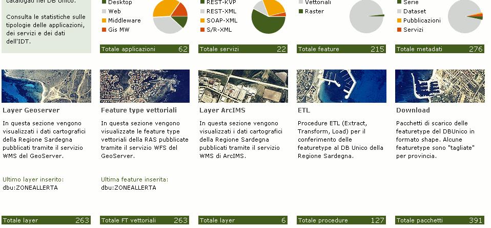
10 View services as cartographic navigators The SDI Geoportal: SardegnaFotoAeree: the basic cartographic navigators; 15 hystorical series of basic orthoimageries of the regional territory since 1954 to SardegnaMappe: like a webgis allows to switch on and off the catalogued basic and thematic data and to query them. Search criteria: coordinates, POI, addresses, toponym. Customizable in several thematizations. 10
11 Network services available Discovery service: - Metadata Catalogue - Feature Catalogue View services: Cartographic navigators with user friendly graphics OGC-WMS: around 6 basic orthoimagery mosaics 11
12 Network services available Download services: - OGC-WFS: around 220 vector data available - Direct download application for the most important basic data Transformation service for coordinates transformation among the most adopted coordinate reference systems in the national territory 12

13 The control panel 13

14 The control panel 14
15 The control panel 15
16 The control panel 16
17 Conclusions and one question SITR-IDT is an almost completely INSPIRE-compliant SDI. Few steps still are required to reach the full compliance. One reflection: plan to invest money for adapting the SDI and make it totally INSPIRE compliant or creating user-oriented services for making the SDI more easily accessible by the community that has financed the SDI? 17
18 www. sardegnaterritorio.it 18
 With the understanding that: Waiver Any of the above conditions can be waived if you get permission")
19 You are free: to Share to copy, distribute and transmit the work to Remix to adapt the work Under the following conditions: Attribution - You must attribute the work in the manner specified by the author or licensor (but not in any way that suggests that they endorse you or your use of the work) With the understanding that: Waiver Any of the above conditions can be waived if you get permission from the copyright holder. Other Rights In no way are any of the following rights affected by the license: Your fair dealing or fair use rights; The author's moral rights; Rights other persons may have either in the work itself or in how the work is used, such as publicity or privacy rights. Notice For any reuse or distribution, you must make clear to others the license terms of this work. 19
SITR-IDT The Spatial Data Infrastructure of Sardinia Region
 ITALY LOCAL AUTHORITY FOR MUNICIPALITIES, FINANCES AND URBAN PLANNING REGIONAL DEPARTMENT FOR CARTOGRAPHY AND INFORMATION SYSTEMS SITR-IDT The Spatial Data Infrastructure of Sardinia Region Content of
Implementing the Smart Growth Priority in an Open and Interoperable System for Geographic Data: Sardinia SITR- IDT
 REGION OF SARDINIA (ITALY) LOCAL AUTHORITY FOR MUNICIPALITIES, FINANCES AND URBAN PLANNING DEPT. FOR THE REGIONAL SPATIAL DATA INFRASTRUCTURE Implementing the Smart Growth Priority in an Open and Interoperable
INSPIRE - A Legal framework for environmental and land administration data in Europe
 INSPIRE - A Legal framework for environmental and land administration data in Europe Dr. Markus Seifert Bavarian Administration for Surveying and Cadastre Head of the SDI Office Bavaria Delegate of Germany
IRDAT Fvg, evolving a regional Spatial Data Infrastructure according to INSPIRE
 IRDAT Fvg, evolving a regional Spatial Data Infrastructure according to INSPIRE Tutti i diritti riservati. Proprietà INSIEL SpA. A. Benvenuti, A. Chiarandini Insiel (Italy) M. Lunardis - Friuli Venezia
Regione Umbria. ESRI EMEA User Conference 2010 Rome, October 27th 2010
 Direzione Ambiente, Territorio e Infrastrutture Servizio Informatico/Informativo: geografico, ambientale e territoriale ESRI EMEA User Conference 2010 Rome, October 27th 2010 Arch. Ambra Ciarapica, Dott.
The Process of Spatial Data Harmonization in Italy. Geom. Paola Ronzino
 The Process of Spatial Data Harmonization in Italy Geom. Paola Ronzino ISSUES Geospatial Information in Europe: lack of data harmonization the lack of data duplication of data CHALLENGES Challenge of INSPIRE:
SITMUN: Cooperating to Build Local SDIs in the Barcelona Region
 SITMUN: Cooperating to Build Local SDIs in the Barcelona Region Diputació de Barcelona Territory and Sustainability Area Territorial Information Systems Department INSPIRE CONFERENCE Barcelona, September
Zagreb Spatial Data Infrastructure. Sanja Batić, APIS IT Split, 14. rujna 2011.
 Zagreb Spatial Data Infrastructure Sanja Batić, APIS IT Split, 14. rujna 2011. Agenda Zagreb Spatial Data Infrastructure - ZIPP Guidelines for further ZIPP Geoportal development Conclusion 1964 The Centre
Horizontal Interoperability among National Geoportals of ES, FR, PT & AD
 Horizontal Interoperability among National Geoportals of ES, FR, PT & AD A. F. Rodríguez S. Mas, D. Richard, J. M. Nataf, D. Furtado, R. P. Julião, S. Pijuan, S. Alba 1 Next 15 minutes Intoduction 4 National
INSPIRing Geospatial Framework For Local Administrations
 This project is financed by the European Union and the Republic of Turkey Presented at the FIG Congress 2018, May 6-11, 2018 in Istanbul, Turkey National Programme for Turkey 2010 Instrument for Pre-Accession
IDEBarcelona: Cooperating for a Smart Region Infrastructure
 IDEBarcelona: Cooperating for a Smart Region Infrastructure Marta Codinachs Serra Diputació de Barcelona Territory and Sustainability Area Territorial Information Systems Department SMART CITY EXPO WORLD
GIS Building Communities beyond National Borders (Building Successful Spatial Data Infrastructures) Nick Land, ESRI Europe
 Nick Land, ESRI Europe") GIS Building Communities beyond National Borders (Building Successful Spatial Data Infrastructures) Nick Land, ESRI Europe UK worst flooding in the last 60 years 350,000 households without drinking water
GIS Building Communities beyond National Borders (Building Successful Spatial Data Infrastructures) Nick Land, ESRI Europe UK worst flooding in the last 60 years 350,000 households without drinking water
Implementing strategy for the Infrastructure for Spatial Information in Europe - INSPIRE Paul Smits
 Implementing strategy for the Infrastructure for Spatial Information in Europe - INSPIRE Paul Smits European Commission DG Joint Research Centre Institute for Environment and Sustainability Ispra, Italy
ArcGIS for INSPIRE. Marten Hogeweg
 ArcGIS for INSPIRE Marten Hogeweg Please Take Our Survey on the App Download the Esri Events app and find your event Select the session you attended Scroll down to find the feedback section Complete answers
QUALITY CONTROL ROLE IN PROCESS OF ESTABLISHMENT OF NSDI
 QUALITY CONTROL ROLE IN PROCESS OF ESTABLISHMENT OF NSDI S. Lemajić a,lj. Rašić b a Croatian Geodetic Institute, Savska 41/XVI, Zagreb, Croatia slavko.lemajic@cgi.hr b State Geodetic Administration, Lastovska
INSPIRE Shared Service
 INSPIRE Shared Service Creation and operation out of the box Petra Fritz (HZD), Michael Voigtländer (Esri Deutschland GmbH) INSPIRE Shared Service Agenda HZD backbone for a geodata infrastructure Implementing
How local communities could profit from Habitats infrastructure
 Social Validation of INSPIRE Annex III Data Structures in EU Habitats How local communities could profit from Habitats infrastructure Andrea Scianna ( Icar CNR Italy ) consultant for Madonie Park Authority
INSPIRE General Introduction & Service Architecture
 INSPIRATION Spatial Data Infrastructure in the Western Balkans INSPIRE General Introduction & Service Architecture 1st National INSPIRATION Workshop Croatia November 21-22, 2012 A multi-countryprojectfunded
Spatial information for urban planning and management case study Zagreb Darko ŠIŠKO, Vlado CETL, Tomislav CICELI. Strasbourg, September 7th, 2017
 Spatial information for urban planning and management case study Zagreb Darko ŠIŠKO, Vlado CETL, Tomislav CICELI Strasbourg, September 7th, 2017 Contents: Cities & INSPIRE Cities in Croatian NSDI City
Roadmap to interoperability of geoinformation
 Roadmap to interoperability of geoinformation and services in Europe Paul Smits, Alessandro Annoni European Commission Joint Research Centre Institute for Environment and Sustainability paul.smits@jrc.it
INSPIRE implementation in the Turkish Ministry of Environment and Urbanization Producing and Publishing Environmental Data
 INSPIRE implementation in the Turkish Ministry of Environment and Urbanization Producing and Publishing Environmental Data Ezgi Sarmusak Urban Planner, MoEU Sibel Süer Toybıyık - Assistant Expert, MoEU
Gistat: moving towards a location information management system
 Gistat: moving towards a location information management system (merging geographical, statistical and historical information) Pina Grazia Ticca Marco Ballin Istat - Italy Aguascalientes, Mexico 2-4 December
Spatial Data Infrastructure Concepts and Components. Douglas Nebert U.S. Federal Geographic Data Committee Secretariat
 Spatial Data Infrastructure Concepts and Components Douglas Nebert U.S. Federal Geographic Data Committee Secretariat August 2009 What is a Spatial Data Infrastructure (SDI)? The SDI provides a basis for
REGION AND STATES INTERCONNEXIONS : CRIGE PACA, SWISSTOPO AND FRENCH PORTALS. Dr. C. Giger (swisstopo) S. Maffren (CRIGE PACA) D.
 S. Maffren (CRIGE PACA) D.") REGION AND STATES INTERCONNEXIONS : CRIGE PACA, SWISSTOPO AND FRENCH PORTALS Dr. C. Giger (swisstopo) S. Maffren (CRIGE PACA) D. Richard (IGN) Components to connect PACA portal French Geoportal Local datasets
REGION AND STATES INTERCONNEXIONS : CRIGE PACA, SWISSTOPO AND FRENCH PORTALS Dr. C. Giger (swisstopo) S. Maffren (CRIGE PACA) D. Richard (IGN) Components to connect PACA portal French Geoportal Local datasets
ISO Series Standards in a Model Driven Architecture for Landmanagement. Jürgen Ebbinghaus, AED-SICAD
 ISO 19100 Series Standards in a Model Driven Architecture for Landmanagement Jürgen Ebbinghaus, AED-SICAD 29.10.2003 The Company 100% SIEMENS PTD SIEMENS Business Services Shareholder & Strategic Business
GRISI: Geomatic Regional Information Society Initiative M. Cabello 1, A. Valentín 2. 2
 GRISI: Geomatic Regional Information Society Initiative M. Cabello 1, A. Valentín 2 1 Trabajos Catastrales, S.A., Pamplona, Spain mcabello@tracasa.es 2 Government of Navarra, SITNA Secretary, Pamplona,
NAG-City Expert Workshop Oslo 8-9. October 2012 SOSI standards and mapping for Europe (INSPIRE)
") NAG-City Expert Workshop Oslo 8-9. October 2012 SOSI standards and mapping for Europe (INSPIRE) Per Ryghaug, Geomatics The Norwegian national standard on geographic information - SOSI Started in 1984 NGU
NAG-City Expert Workshop Oslo 8-9. October 2012 SOSI standards and mapping for Europe (INSPIRE) Per Ryghaug, Geomatics The Norwegian national standard on geographic information - SOSI Started in 1984 NGU
From the Venice Lagoon Atlas towards a collaborative federated system
 From the Venice Lagoon Atlas towards a collaborative federated system City of Venice Alessandro Mulazzani CORILA Consortium for Coordination of Research Activities Concerning the Venice Lagoon System ISMAR-CNR
Status of implementation of the INSPIRE Directive 2016 Country Fiches. COUNTRY FICHE Finland
 Status of implementation of the INSPIRE Directive 2016 Country Fiches COUNTRY FICHE Finland Introduction... 1 1. State of Play... 2 1.1 Coordination... 2 1.2 Functioning and coordination of the infrastructure...
INSPIRE and Land Use Planning System in Portugal
 INSPIRE and Land Use Planning System in Portugal Rui Amaro Alves Director General Directorate General for Territorial Development ruialves@dgterritorio.pt Carlos Simões Senior Technician Directorate General
A FOSS approach to Integrated Water Resource Management: the case study of Red-Thai Binh rivers system in Vietnam
 A FOSS approach to Integrated Water Resource Management: the case study of Red-Thai Binh rivers system in Vietnam Carolina Arias Munoz1, Maria Antonia Brovelli1, Simone Corti1, Marco Micotti2, Rodolfo
Spatial Data Infrastructures in Greece: State of play Spring 2003
 Spatial Data Infrastructures in : State of play Spring 2003 Country report on SDI elaborated in the context of a study commissioned by the EC (EUROSTAT & DGENV) in the framework of the INSPIRE initiative
ArcGIS for INSPIRE. Marten Hogeweg Satish Sankaran
 ArcGIS for INSPIRE Marten Hogeweg Satish Sankaran Outline What is ArcGIS ArcGIS for INSPIRE Web GIS Case Studies Roadmap Q&A What is INSPIRE? INSPIRE is the legal framework for a European Spatial Data
MedIsolae-3D. Mediterranean Islands SDI and 3D Aerial Web Navigation. Giacomo Martirano. (Epsilon Italia)
") MedIsolae-3D Mediterranean Islands SDI and 3D Aerial Web Navigation Giacomo Martirano (Epsilon Italia) GSDI 11 WORLD CONFERENCE 15-19 June, Rotterdam, The Netherlands Presentation Overview SDIs for the
MedIsolae-3D Mediterranean Islands SDI and 3D Aerial Web Navigation Giacomo Martirano (Epsilon Italia) GSDI 11 WORLD CONFERENCE 15-19 June, Rotterdam, The Netherlands Presentation Overview SDIs for the
Global Geospatial Information Management Country Report Finland. Submitted by Director General Jarmo Ratia, National Land Survey
 Global Geospatial Information Management Country Report Finland Submitted by Director General Jarmo Ratia, National Land Survey Global Geospatial Information Management Country Report Finland Background
UNIPD RESEARCH UNIT Progress Report Francesca FISSORE, Marco PIRAGNOLO, Francesco PIROTTI
 UNIPD RESEARCH UNIT Progress Report Francesca FISSORE, Marco PIRAGNOLO, Francesco PIROTTI PRIN PROJECT: URBAN GEOmatics for Bulk Information Generation, Data Assessment and Technology Awareness UR UniPD
Technical Specifications. Form of the standard
 Used by popular acceptance Voluntary Implementation Mandatory Legally enforced Technical Specifications Conventions Guidelines Form of the standard Restrictive Information System Structures Contents Values
TERMS OF REFERENCE FOR PROVIDING THE CONSULTANCY SERVICES OF
 1 Cartographic Database and TM100 Product Specifications TERMS OF REFERENCE FOR PROVIDING THE CONSULTANCY SERVICES OF Production and establishment of cartographic database for scale 1:100,000 and production
Implementing INSPIRE Geoportal in Turkey
 Implementing INSPIRE Geoportal in Turkey Gencay SERTER City and Regional Planner 1 Presentation Plan Introduction INSPIRE and Turkey Importance of al Spatial Planning Portal Logical&Legal Hierarchy GeoPortal
The state-of-the-art of the Finnish SDI. Arctic SDI WG Meeting
 The state-of-the-art of the Finnish SDI Arctic SDI WG Meeting Moscow 8.9.2011 Esa Tiainen Development Centre 1 NATIONAL LAND SURVEY DOWN TO EARTH Contents Legal framework Coordination structure Network
SDI-Challenges European perspective
 THE HIGH LEVEL FORUM ON GLOBAL GEOSPATIAL INFORMATION MANAGEMENT Seoul, Republic of Korea, 24-26 October 2011 Session 1: Challenges in geospatial policy formation and institutional arrangements SDI-Challenges
a national geological survey perspective François ROBIDA BRGM (French Geological Survey)
") a national geological survey perspective François ROBIDA BRGM (French Geological Survey) Pre-Conference Seminar on Socio-Economic Value of Geospatial for National and Regional Development 21 August 2017,
a national geological survey perspective François ROBIDA BRGM (French Geological Survey) Pre-Conference Seminar on Socio-Economic Value of Geospatial for National and Regional Development 21 August 2017,
Implementation of Inspire in Denmark - How we get it flying! Olav Eggers National Survey & Cadastre -Denmark
 Implementation of Inspire in Denmark - How we get it flying! Olav Eggers oe@kms.dk National Survey & Cadastre -Denmark Introduction Overview Infrastructure for Spatial Information Act National Survey and
Land Board, NW Services and SDI Tambet Tiits, FRICS
 Land Board, NW Services and SDI Tambet Tiits, FRICS 07.09.2016 200th anniversary of the Struve Geodetic Arc Friedrich Georg Wilhelm Struve and Carl Friedrich Tenner Struve Geodetic Arc The Struve Geodetic
Estonian approach to implementation of INSPIRE directive. Sulev Õitspuu Head of Bureau of Geoinfosystems Estonian Land Board
 Estonian approach to implementation of INSPIRE directive Sulev Õitspuu Head of Bureau of Geoinfosystems Estonian Land Board 13.06.2016 Contents - INSPIRE coordination in Estonia - INSPIRE implementation
A Spatial Data Infrastructure dedicated to scientific research and observation of the coastal environment
 A Spatial Data Infrastructure dedicated to scientific research and observation of the coastal environment http://indigeo.fr Mathias ROUAN - Research Engineer - UMR 6554 LETG CNRS Littoral, Environment,
Ready for INSPIRE.... connecting worlds. European SDI Service Center
 Ready for INSPIRE Consultancy SOFTWARE T r a i n i n g Solutions... connecting worlds European SDI Service Center Increasing Added Value with INSPIRE and SDI Components INSPIRE In 2007, the European Commission
Implementing INSPIRE in Sweden
 Implementing INSPIRE in Sweden Christina Wasström NSDI-unit, Lantmäteriet Christina.wasstrom@lm.se Standards Cooperation Metadata Competence Infrastructure for Geodata Legal Framework Portal Services Geodata
A Spatial Data Infrastructure for Landslides and Floods in Italy
 V Convegno Nazionale del Gruppo GIT Grottaminarda 14 16 giugno 2010 A Spatial Data Infrastructure for Landslides and Floods in Italy Ivan Marchesini, Vinicio Balducci, Gabriele Tonelli, Mauro Rossi, Fausto
Project based approach developing National Spatial Data Infrastructure in Lithuania
 Project based approach developing National Spatial Data Infrastructure in Lithuania National Land Service under the Ministry of Agriculture of The Republic of Lithuania Cadastres & Geodesy Department Director
Spatial data interoperability and INSPIRE compliance the platform approach BAGIS
 Spatial data interoperability and INSPIRE compliance the platform approach BAGIS BAGIS Voluntary, independent, public, non-profit organization; Organization with main mission to promote the growth of the
Spatially Enabled Society
 International Seminar on Land Administration Trends and Issues in Asia and the Pacific Region Spatially Enabled Society Abbas Rajabifard Vice Chair PCGIAP-WG3 Vice-President (President Elect), GSDI Association
Modular Web Framework for the BRANDENBURGVIEWER
 Modular Web Framework for the BRANDENBURGVIEWER Geoinformation System (GIS) 2 GIS = geo + information + system + + Survey of data Organization of data Processing and Analysis Presentation geodata infrastructure
Technical Framework Methodology as a core of building up the NSDI NSDI Implementation Specifics in Serbia
 Technical Framework Methodology as a core of building up the NSDI NSDI Implementation Specifics in Serbia Luka Jovičić SDI Consultant@ Gramont Ltd. Aleksandar Dedić RGA NSDI department Dragica Pajić RGA
Discovery and Access of Geospatial Resources using the Geoportal Extension. Marten Hogeweg Geoportal Extension Product Manager
 Discovery and Access of Geospatial Resources using the Geoportal Extension Marten Hogeweg Geoportal Extension Product Manager DISCOVERY AND ACCESS USING THE GEOPORTAL EXTENSION Geospatial Data Is Very
ArcGIS for INSPIRE. Paul Hardy. ArcGIS. ArcGIS for INSPIRE Enables Esri ArcGIS users to implement and comply with INSPIRE. INSPIRE Data Themes
 Enables Esri ArcGIS users to implement and comply with INSPIRE Paul Hardy phardy@esri.com EuroGeographics INSPIRE KEN (Schema Transformation) 8/9 October 2013, Marne la Vallée INSPIRE Data Themes Annex
Norwegian spatial data infrastructure supporting disaster risk management Norwegian Mapping Authority
 Norwegian spatial data infrastructure supporting disaster risk management Norwegian Mapping Authority Arvid Lillethun, Norwegian Mapping Authority Land and Poverty 2018 Conference, World Bank 19.-23. March
Portals: Standards in Action
 Portals: Standards in Action David Danko ISO TC 211 Metadata Project Leader GIS Standards Consultant-ESRI. Metadata Portals Portal gateway, place of entry Producers Advertise, expose products Share information
Key Points Sharing fosters participation and collaboration Metadata has a big role in sharing Sharing is not always easy
 Sharing Resources Geoff Mortson esri, Inc. SDI Solutions Team Key Points Sharing fosters participation and collaboration Metadata has a big role in sharing Sharing is not always easy Data Sharing is Good
SWEDISH SDI DEVELOPMENT & IMPLEMENTATION OF INSPIRE
 SWEDISH SDI DEVELOPMENT & IMPLEMENTATION OF INSPIRE Christina Wasström, Lantmäteriet, 801 82 Gävle, Sweden, christina.wasstrom@lm.se ABSTRACT The Swedish Government and Parliament has given Lantmäteriet
SDI in Finland Nordic SDI Seminar Uppsala Panu Muhli
 SDI in Finland Nordic SDI Seminar Uppsala 3.10.2011 Panu Muhli Spatial Data Infrastructure Team Inspire secretariat Development Centre 1 NATIONAL LAND SURVEY DOWN TO EARTH Contents Legal framework Coordination
Proposal for a DIRECTIVE OF THE EUROPEAN PARLIAMENT AND OF THE COUNCIL. establishing an infrastructure for spatial information in the Community
 Proposal for a DIRECTIVE OF THE EUROPEAN PARLIAMENT AND OF THE COUNCIL establishing an infrastructure for spatial information in the Community INSPIRE http://inspire.jrc.it/ Alessandro Annoni 1 EU Commission
Finding geodata that otherwise would have been forgotten GeoXchange a portal for free geodata
 Finding geodata that otherwise would have been forgotten GeoXchange a portal for free geodata Sven Tschirner and Alexander Zipf University of Applied Sciences FH Mainz Department of Geoinformatics and
The Swedish National Geodata Strategy and the Geodata Project
 The Swedish National Geodata Strategy and the Geodata Project Ewa Rannestig, Head of NSDI Co-ordination Unit, Lantmäteriet, ewa.rannstig@lm.se Ulf Sandgren, Project Manager Geodata Project, Lantmäteriet,
Geoíndex: a public data dissemination service from the IGC. Geoíndex IGC Team Reporter: Carme Puig
 Geoíndex: a public data dissemination service from the IGC Geoíndex IGC Team Reporter: Carme Puig 2 Brief IGC introduction The IGC was created through the Law 19/2005 of the Catalan Parliament. The IGC
INSPIREd solutions for Air Quality problems Alexander Kotsev
 INSPIREd solutions for Air Quality problems Alexander Kotsev www.jrc.ec.europa.eu Serving society Stimulating innovation Supporting legislation The European data puzzle The European data puzzle 24 official
RESOURCES DEVELOPMENT GEOSPATIAL DATA USING THE DIGITAL TOPOGRAPHIC PLAN OF ROMANIA- TOPRO5
 C. C-tin Muşat, F. M. Brebu, A. C. Bălă, I. S. Herban Resources Development Digital Geospatial Data Using the Digital Topographic Plan of Romania - TOPRO5 RESOURCES DEVELOPMENT GEOSPATIAL DATA USING THE
UNOFFICIAL TRANSLATION
 UNOFFICIAL TRANSLATION THE CROATIAN PARLIAMENT 1135 Pursuant to Article 89 of the Constitution of the Republic of Croatia, I hereby issue the DECISION PROMULGATING THE NATIONAL SPATIAL DATA INFRASTRUCTURE
Linked Open Data From OGC Compliant Web Services: The Case of Regione Emilia - Romagna Geoportal
 Linked Open Data From OGC Compliant Web Services: The Case of Regione Emilia - Romagna Geoportal Inspire Conference Florence 26/06/2013 Giovanni Ciardi (Regione Emilia-Romagna) Alfredo Abrescia (Planetek
SDI Development in Georgia. Mari Khardziani Head of International Relations Unit National Agency of Public Registry
 SDI Development in Georgia Mari Khardziani Head of International Relations Unit National Agency of Public Registry Kehl, Germany September 5, 2017 2 National Agency of Public Registry Legal Entity of Public
Solving the European Data Puzzle Simplifying INSPIRE Challenges and Usage. con terra GmbH Dipl.-Ing. Mark Döring
 Solving the European Data Puzzle Simplifying INSPIRE Challenges and Usage con terra GmbH Dipl.-Ing. Mark Döring INSPIRE Reference Projects GeoBAK 2.0 Project // INSPIRE Data & Services The Project Evolution
INSPIRE Monitoring and Reporting Implementing Rule Draft v2.1
 INSPIRE Infrastructure for Spatial Information in Europe INSPIRE Monitoring and Reporting Implementing Rule Draft v2.1 Title INSPIRE Monitoring and Reporting Implementing Rule v2.1 Creator DT Monitoring
Arctic Spatial Data Infrastructure
 Arctic Spatial Data Infrastructure à Enabling Access to Arctic Land and Marine Data Across Borders, Across Time Simon Riopel, GeoConnections Canada Centre for Mapping and Earth Observation Draft Outline
gvsig: Open Source Solutions in spatial technologies
 gvsig: Open Source Solutions in spatial technologies gvsig is a tool for handling geographical information, a completely GIS client with license GNU GPL. Alvaro A. Anguix Alfaro, Gabriel Carrión Rico Conselleria
SDI in Lombardia (Italy(
 SDI in Lombardia (Italy( Italy) Andrea Piccin European SDI Best Practice Awards 2009 - Learning from Best Practices Turin, 26th and 27th November 2009 Lombardia, in Italy, is 4 th Region for territorial
Standards in Action: The Canadian Geospatial Data Infrastructure (CGDI)
") Standards in Action: The Canadian Geospatial Data Infrastructure (CGDI) Craig Stewart ISO/TC211 Standards in Action Workshop, September 14, 2005 Presentation Outline Overview of SDIs Overview of Canada
Standards in Action: The Canadian Geospatial Data Infrastructure (CGDI) Craig Stewart ISO/TC211 Standards in Action Workshop, September 14, 2005 Presentation Outline Overview of SDIs Overview of Canada
Increasing GI awareness in local authorities in Poland experiences from the INSPIRE Academy training programme
 Increasing GI awareness in local authorities in Poland experiences from the INSPIRE Academy training programme http://www.akademiainspire.pl Maria Andrzejewska, Monika Rusztecka UNEP/GRID-Warsaw Centre,
INSPIRE in Sweden - an Important Part of the National Geodata Strategy
 INSPIRE in Sweden - an Important Part of the National Geodata Strategy Ewa RANNESTIG and Monica LAGERQVIST NILSSON, Sweden Key words: National Geodata Strategy, National Infrastructure for Spatial Information,
Oman NSDI Supporting Economic Development. Saud Al-Nofli Director of Spatial Data Directorate General of NSDI, NCSI
 Oman NSDI Supporting Economic Development 2017 Saud Al-Nofli Director of Spatial Data Directorate General of NSDI, NCSI "It s critical to make correct decisions the first time to optimize the Investments
Evaluating e-government : implementing GIS services in Municipality
 Evaluating e-government : implementing GIS services in Municipality Municipality of Thessaloniki - G.I.S. Unit Misirloglou Symeon Head of the GIS Unit ESRI UC - 2016 The GIS Section - subset of the department
Upgrade the Datasets in NSDI for Smarter Services with the Cases of China
 Upgrade the Datasets in NSDI for Smarter Services with the Cases of China By Dr. JIANG Jie Dept of GeoInformaiton Service Platform National Geomatics Center of China October 7, 2015 Jeju, Republic of Korea
Demonstration of a local SDI solution with several stakeholders in pilot areas in line with EU best practices
 EU Twinning project for the Agency of Land Relations and Cadaster (ALRC)- Organization, Streamlining and Computerization Process in Mapping in the Republic of Moldova. Demonstration of a local SDI solution
DGIWG 200. Defence Geospatial Information Framework (DGIF) Overview
 Overview") DGIWG 200 Defence Geospatial Information Framework (DGIF) Overview Document type: Standard Document date: 28 November 2017 Edition: 2.0.0 Responsible Party: Audience: Abstract: Copyright: Defence Geospatial
DGIWG 200 Defence Geospatial Information Framework (DGIF) Overview Document type: Standard Document date: 28 November 2017 Edition: 2.0.0 Responsible Party: Audience: Abstract: Copyright: Defence Geospatial
Innovation in Land Management: Integrated Solutions For National Cadastre Projects
 Success With GIS Innovation in Land Management: Integrated Solutions For National Cadastre Projects XXIII International FIG Congress Munich These documents are only complete, when used in connection with
Testing of Geoportals: INSPIRE demands and challenges
 Testing of Geoportals: INSPIRE demands and challenges Imad Abugessaisa & Solgerd Tanzilli Lantmäteriet - Swedish Mapping, Cadastre and Land Registration Authority / Future Position X, Gävle INSPIRE 2010
Using OGC standards to improve the common
 Using OGC standards to improve the common operational picture Abstract A "Common Operational Picture", or a, is a single identical display of relevant operational information shared by many users. The
INSPIRE Implementation in Estonia using ArcGIS
 INSPIRE Implementation in Estonia using ArcGIS Sulev Õitspuu Head of Bureau of Geoinfosystems Estonian Land Board 26.09.2016 Population: 1,3 million (69% Estonians) Area: 45,339 km 2 15 counties Estonia
A decade of geoinformation sharing at ETH Zurich
 A decade of geoinformation sharing at ETH Zurich Ionuț Iosifescu-Enescu, Cristina Iosifescu-Enescu, Nadia H. Panchaud, Angeliki Tsorlini, Lorenz Hurni {iosifescu,ciosifescu,nadia.panchaud,atsorlini,lhurni}@ethz.ch
Improving waste water management support from the European Structural and Investment Funds
 Improving waste water management support from the European Structural and Investment Funds 4 th meeting of the CoR/EC Technical Plateform for Cooperation on the Environment Wednesday 8 October 2014 Development
ESTABLISHMENT OF KARNATAKA GEOPORTAL AND ITS ROLE IN PLANNING
 ESTABLISHMENT OF KARNATAKA GEOPORTAL AND ITS ROLE IN PLANNING By H. Hemanth Kumar Karnataka State Council for Science & Technology (KSCST), Indian Institute of Science, Bangalore, India Abstract Natural
Infrastructure for Spatial Information in Europe (INSPIRE)
") Infrastructure for Spatial Information in Europe (INSPIRE) 2011 GISCO Working Party 8-9.3.2012 INSPIRE is about improving access to spatial information: the environment doesn t stop at borders EU Geoportal
Infrastructure for Spatial Information in Europe (INSPIRE) 2011 GISCO Working Party 8-9.3.2012 INSPIRE is about improving access to spatial information: the environment doesn t stop at borders EU Geoportal
ESDIN Results from a Crossborder INSPIRE Preparatory Project. Jörgen Hartnor, Lantmäteriet.
 ESDIN Results from a Crossborder INSPIRE Preparatory Project Jörgen Hartnor, Lantmäteriet www.esdin.eu Ett econtentplus Best Practice Network projekt September 2008 February 2011 Coordinated by EuroGeographics
INSPIRE Basics. Vlado Cetl European Commission Joint Research Centre. https://ec.europa.eu/jrc/
 INSPIRE Basics Vlado Cetl European Commission Joint Research Centre https://ec.europa.eu/jrc/ Serving society Stimulating innovation Supporting legislation Outline SDI? Why European SDI? INSPIRE Policy
Harmonisation of Spatial Planning Data
 INSPIRE Conference 18 June 2011 Edinburgh, Great Britain Harmonisation of Spatial Planning Data Tomas Mildorf University of West Bohemia mildorf@centrum.cz Pilsen, Czech Republic Co-funded by the Community
Data Aggregation with InfraWorks and ArcGIS for Visualization, Analysis, and Planning
 Data Aggregation with InfraWorks and ArcGIS for Visualization, Analysis, and Planning Stephen Brockwell President, Brockwell IT Consulting, Inc. Join the conversation #AU2017 KEYWORD Class Summary Silos
GMES Service for Geospatial Reference Data Access (RDA) Covering Areas Outside Europe
 Covering Areas Outside Europe") INSPIRE Conference 2011 Edinburgh 27 June - 1 July GMES Service for Geospatial Reference Data Access (RDA) Covering Areas Outside Europe Andrea Ajmar, Simone Balbo, Piero Boccardo, Simone Dalmasso, Anna
INSPIRE Conference 2011 Edinburgh 27 June - 1 July GMES Service for Geospatial Reference Data Access (RDA) Covering Areas Outside Europe Andrea Ajmar, Simone Balbo, Piero Boccardo, Simone Dalmasso, Anna
EXPECTATIONS OF TURKISH ENVIRONMENTAL SECTOR FROM INSPIRE
 EXPECTATIONS OF TURKISH ENVIRONMENTAL SECTOR FROM INSPIRE June, 2010 Ahmet ÇİVİ Tuncay DEMİR INSPIRE in the Eyes of MoEF Handling of Geodata by MoEF Benefits Expected TEIEN First Steps for INSPIRE Final
Status of implementation of the INSPIRE Directive 2016 Country Fiches. COUNTRY FICHE Spain
 Status of implementation of the INSPIRE Directive 2016 Country Fiches COUNTRY FICHE Spain Introduction... 1 1. State of Play... 2 1.1 Coordination... 2 1.2 Functioning and coordination of the infrastructure...
INSPIRE Implementation Stories and Data Harmonization Solution Patterns at Land Management Agencies Across Europe
 INSPIRE Implementation Stories and Data Harmonization Solution Patterns at Land Management Agencies Across Europe Dean Hintz, Safe Software Sören Dupke, con terra Agenda FME & INSPIRE Consuming, Writing
Overview of Geospatial Open Source Software which is Robust, Feature Rich and Standards Compliant
 Overview of Geospatial Open Source Software which is Robust, Feature Rich and Standards Compliant Cameron SHORTER, Australia Key words: Open Source Geospatial Foundation, OSGeo, Open Standards, Open Geospatial