Finding geodata that otherwise would have been forgotten GeoXchange a portal for free geodata
|
|
|
- Sherman Davidson
- 5 years ago
- Views:
Transcription
1 Finding geodata that otherwise would have been forgotten GeoXchange a portal for free geodata Sven Tschirner and Alexander Zipf University of Applied Sciences FH Mainz Department of Geoinformatics and Surveying i3mainz - Institute for Spatial Information and Surveying Technology Holzstrasse Mainz, Germany zipf@geoinform.fh-mainz.de Abstract. A key problem of small organizations like departments of geography, ecology, geodesy, architecture, landscape planning, archeology etc is, that they also produce from time to time some spatial data mostly in small projects or master theses or PhD thesis. This data is usually not included in any spatial data infrastructure. Therefore we developed a GeoPortal the geoxchange Portal - that gives the possibility to store, annotate and share such geodata produced by small institutions that do not have the resources to build up a SDI on their own. The portal is realized using open standards of OGC, ISO and W3C. It allows describing the geodata sets with metadata according to ISO (CORE) as well as Dublin Core. This metadata can be queried using a Web Interface to an OGC conformant Catalog Service (CSW) and also using a graphical map interface (bounding-box) through a Web Map Service (WMS). Geodata itself can be uploaded to the portal directly though a transactional Web Feature Service (WFS) through which it also can be accessed. Uploaded data is made automatically available via the map query interface, too, in order to allow visual queries. 1 Introduction A lot of initiatives, organizations and projects start to develop spatial data infrastructures (SDI) in order to ease access and use of their spatial data and geo-services. Most of these projects care for geodata that is being generated either by federal agencies or by big organizations. A key problem of small organizations like departments of geography, ecology, geodesy, architecture, landscape planning, archeology etc is, that they also produce from time to time some spatial data mostly in small projects or master theses or PhD thesis. This data is usually not included in any spatial data infrastructure. In the contrary, in nearly all time the data is forgotten and lost after the respective project or thesis finishes or the person directly involved with generating the data has left the organization. While the individual dataset that has been produced
2 may be small, the cumulative loss of all that data sets over the years on an international scale is enormous and not acceptable. The generated data sets usually are not even put to the Web and even when they usually are not found by search engines (except for exceptions like GeoMeta.Info (xxx). At least they are not found using standard catalog services using structured search capabilities including parameters like: BoundingBox, Thematic and temporal aspects. Further the data comes in a variety of formats, leaving the future user the task to convert this into the desired format and spatial reference system. The only solution is to make these kinds of data sets available worldwide via standardized interfaces and Metadata. While indeed such data sets from research results are sometimes published on the web, the data itself isn t documented at all or even if it is it is badly. This means that it will either be not found a all in the first place or even when it has been found, it cannot be used adequately because of the lack of metadata which renders the whole dataset useless after the person that produced the data is no longer available. We therefore developed an first version of a GeoPortal the geoxchange Portal - that gives the possibility to store, annotated and share geodata of these small institutions, projects or persons that usually do not have the resources to build up a spatial data infrastructure (SDI) on their own. The portal is realized with open source software and developed using open standards of the OGC, ISO and W3C. Most important it allows to describe the geodata sets with metadata according to ISO (currently CORE). This metadata can be queried using a Web Interface to an OGC conformant Catalog Service (CSW) and also using a graphical map interface through a Web Map Service. The data itself can be uploaded to our Portal directly though a transactional Web Feature Service (WFS) through which it also can be accessed. As the WFS itself only supports GML we additionally realized the automatic Web-based conversion from other proprietary datasets to GML and vice versa in order to ease the use of the portal for people without the technical background or access to a full GIS package. During the upload process the geodata is usually converted to a common Spatial Reference System (CRS) and by default written to the database Postgres which is the standard datastore. Technical Issues and Architecture In the following section we present a short overview on the architecture and technical background of the project. The Geoportal has been realized using the Java Struts-Framework, which is based on Java Server Pages (JSP) and Java Servlets running in a Jakarta-Tomcat Servlet Container. Some parts of the user interface also use Javascript. The database where all the geodata as well the metadata is being stored is postgresql with the postgis extension in order to allow storing of spatial data in an OGC compliant way as simple features with their respective set of methods for converting, describing and analysing (geometrical/topological) the geodata.
 (realized through the geoserver project) as well as a Web Map Service (WMS).")
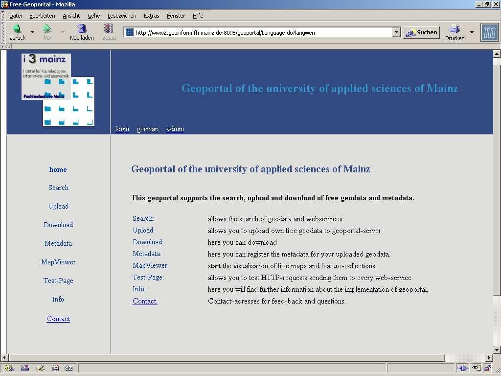
3 The portal consists of different Web applications: The Catalog Service (degree) manages all metadata and allows querying and filtering these in order to find datasets according to the search criteria. A transactional Web Feature Service (WFS) (realized through the geoserver project) as well as a Web Map Service (WMS). Last there is the portal itself which consists of the client-applications (frontend for the user) that communicates with the different web services (Catalog Service, WFS, WMS) through http-requests (mostly exchanging XMLdocuments). figure 1: UML-diagram of the used components User Interface and Search capabilities Dependent from the format of the data that has been uploaded and the converting tools used provided by geoxchange there are different download formats available. In any case the geodata can be downloaded in the format in which they were uploaded and also as ESRI Shape-files and of course as GML as the standard output of the Web Feature Service. Search: Upload: Download: Metadata: MapViewer: Test-Page Info: Contact: allows the search of geodata and webservices. allows you to upload own free geodata to geoportal-server. allows the user to download geodata allows the user to register metadata for the geodata he has uploaded. starts the visualization of free maps and feature-collections. allows to test HTTP-requests sending them to a web-service. information about the implementation of geoportal is available Contact-adresses for feedback and questions.
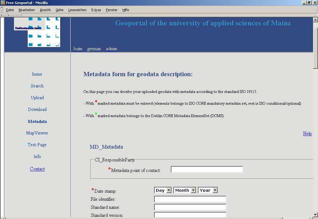
4 The user has the possibility to insert the metadata into the database either with graphical user interface or per upload of ISO-XML- or DublinCore-RDF files. Using the search user interface the user has the possibility to search for all ISO Core Metadata-elements provided by the current implementation of the portal. Due to limitations in manpower we do not yet support all metadata elements (>300), but only a small subset. We will extend the supported set of metadata elements in future releases of the geoxchange portal. Inserting metadata is always a time-consuming task and in most cases only a minimal set of metadata elements are actually dilled in in most projects. Automated extraction of metadata elements from existing datasets is still a research issue (Manso 2005) and we could not work on this in detail so far. The following search criteria are available within the current prototype: Title/keywords The important criteria is the one with which you can search for words in the title or optional in the abstract, the latter one is a short describing text about the geodata. Features of the text search: Extract terms with a leading minus: -term Insert word groups with quotation marks: "word group" An automatic search over upper and lower case letters and with the first letter to upper case: if input equals: input terms will be searched for: input,input,input and input Search in the abstract element optionally Search for all words optionally: result contains only metadata sets which have fullfill all the entered word conditions Category The user can choose from a predetermined list of topic categories, the corresponding term for the data searched. This list matches the domain elements of the ISO-Core metadata element "Topic category". Date (of creation, publishing, updating): The user can select the temporal limitations for his search. Currently this search criteria will only regard the element "Dataset reference date" of the ISO Core metadata set, comparable or rather mapped to the DublinCore element "Date", due to limitations of the Catalog service used. But this limitation will be extended soon to a more exhaustive temporal search. Location: At the moment the local search is implemented by receiving the coordinates of the smallest surrounded bounding box (=rectangle)out of a map-display which shows you a world-map to zoom in and out. With every zoom in or with specifying an area of interest (=rectangle as the former described bounding box) new bounding coordinates are displayed on the right side. To activate the local search, set the option field activate to true. Maybe in the future, it could be possible to integrate a Gazetteer Service with which a geographic term like "Berlin" could be inserted in a textfield and then
5 would be transformated in the same bounding box coordinates as it is done with the world-map. Another feature would be a Thesauri, a synonym dictionary to receive the official geographic name if you enter only a regional known term for a city, river, state and so on. Conclusion and Outlook This first version of the portal is going online in 2005 and will be extended until the end of the year to also support raster data (Web Coverage Server) and more extensible search capabilities which include also the search in other OGC Catalogs that are currently being made available worldwide in Europe most of all inspired through the INSPIRE initiative as an aggregate search within several OGC catalog services, that are being developed in several organizations at the moment. Further the more extensive use of Gazetteer services in combination with Thesaurus Services is planned and we are also watching the work on Web Ontology Services in order to see when there is a good chance to integrate these developments into the portal. Further we need to raise awareness within the institutions that possibly could contribute datasets on the one hand side and on the other hand side also find existing datasets and include them into our database. Future extensions include the integration of 2,5 dimensional digital elevation models (DEM) and 3D geodata (3D city models). Work in this direction is already in progress, but with a focus on implementing the basic software components that would be needed for a 3D-geodata infrastructure. References 1. Baldonado, M., Chang, C.-C.K., Gravano, L., Paepcke, A.: The Stanford Digital Library Metadata Architecture. Int. J. Digit. Libr. 1 (1997) Reuter, A. and Zipf, A. (2005 in print): GIScience - Where Next. In: Fotheringham S. and Wilson, J.P. (eds.): Handbook to GIS. Blackwell Publishers. (due Sept. 2005) 3. Zipf, A. (2003): How to enrich GIS development through aspects using formal ontologies. GISRUK GIS Research UK. London. 4. Zipf, A. and Krüger, S. (2001): TGML - Extending GML by Temporal Constructs - A Proposal for a Spatiotemporal Framework in XML. ACM-GIS The Ninth ACM International Symp. on Advances in Geographic Information Systems. Atlanta. USA. 5. Nogueras-Iso, J. (2005): WEB ONTOLOGY SERVICE, A KEY COMPONENT OF A SPATIAL DATA INFRASTRUCTURE 11th EC-GI & GIS Workshop, ESDI: Setting the Framework Alghero, Sardinia, 29th June - 1st July Vaccari; L. et al. (2005): A SERVICE ORIENTED APPROACH FOR GEOGRAPHICAL DATA SHARING: 11th EC-GI & GIS Workshop, ESDI: Setting the Framework Alghero, Sardinia, 29th June - 1st July Manso, M. A. et al. (2005): NEW ADVANCES IN THE AUTOMATIC METADATA RETRIEVAL FROM GEOGRAPHIC INFORMATION. 11th EC-GI
: INSPIRE - STATE OF PLAY STUDY: STATUS OF THE NATIONAL SPATIAL DATA INFRASTRUCTURES IN EUROPE. 11th EC- GI & GIS Workshop, ESDI: Setting the Framework.")
6 & GIS Workshop, ESDI: Setting the Framework. Alghero, Sardinia, 29th June - 1st July Vandenbroucke, D. (2005): INSPIRE - STATE OF PLAY STUDY: STATUS OF THE NATIONAL SPATIAL DATA INFRASTRUCTURES IN EUROPE. 11th EC- GI & GIS Workshop, ESDI: Setting the Framework. Alghero, Sardinia, 29th June - 1st July Ostländer, N. (2005): DEVELOPING AN SDI FOR TIME-VARIANT AND MULTI-LINGUAL INFORMATION DISSEMINATION AND DATA DISTRIBUTION. 11th EC-GI & GIS Workshop, ESDI: Setting the Framework. Alghero, Sardinia, 29th June - 1st July Attachments: Screenshots of the current geoxchange portal prototype
7


8 Fig. 1. Example of the User Interface

9 Fig. 1. Example of the User Interface
Spatial Data Infrastructure Concepts and Components. Douglas Nebert U.S. Federal Geographic Data Committee Secretariat
 Spatial Data Infrastructure Concepts and Components Douglas Nebert U.S. Federal Geographic Data Committee Secretariat August 2009 What is a Spatial Data Infrastructure (SDI)? The SDI provides a basis for
The EOC Geoservice: Standardized Access to Earth Observation Data Sets and Value Added Products
 The EOC Geoservice: Standardized Access to Earth Observation Data Sets and Value Added Products Klaus Dengler, Torsten Heinen, Albert Huber, Katrin Molch, Eberhard Mikusch DLR German Remote Sensing Data
Portals: Standards in Action
 Portals: Standards in Action David Danko ISO TC 211 Metadata Project Leader GIS Standards Consultant-ESRI. Metadata Portals Portal gateway, place of entry Producers Advertise, expose products Share information
THE WASHINGTON COASTAL ATLAS
 THE ICAN COASTAL ATLAS MEDIATOR PROTOTYPE AND CONNECTING THE WASHINGTON COASTAL ATLAS Liz O Dea 1, Yassine Lassoued 2, Tanya Haddad 3, Declan Dunne 2 1 GIS Services Unit, WA State Dept. of Ecology 2 Coastal
Discovery and Access of Geospatial Resources using the Geoportal Extension. Marten Hogeweg Geoportal Extension Product Manager
 Discovery and Access of Geospatial Resources using the Geoportal Extension Marten Hogeweg Geoportal Extension Product Manager DISCOVERY AND ACCESS USING THE GEOPORTAL EXTENSION Geospatial Data Is Very
Paper UC1351. Conference: User Conference Date: 08/10/2006 Time: 8:30am-9:45am Room: Room 23-B (SDCC)
") Conference: User Conference Date: 08/10/2006 Time: 8:30am-9:45am Room: Room 23-B (SDCC) Title of Paper: Increasing the Use of GIS in the Federal Government Author Name: Miss Abstract This presentation
Conference: User Conference Date: 08/10/2006 Time: 8:30am-9:45am Room: Room 23-B (SDCC) Title of Paper: Increasing the Use of GIS in the Federal Government Author Name: Miss Abstract This presentation
Overview of Geospatial Open Source Software which is Robust, Feature Rich and Standards Compliant
 Overview of Geospatial Open Source Software which is Robust, Feature Rich and Standards Compliant Cameron SHORTER, Australia Key words: Open Source Geospatial Foundation, OSGeo, Open Standards, Open Geospatial
SITR-IDT The Spatial Data Infrastructure of Sardinia Region
 ITALY LOCAL AUTHORITY FOR MUNICIPALITIES, FINANCES AND URBAN PLANNING REGIONAL DEPARTMENT FOR CARTOGRAPHY AND INFORMATION SYSTEMS SITR-IDT The Spatial Data Infrastructure of Sardinia Region Content of
Using OGC standards to improve the common
 Using OGC standards to improve the common operational picture Abstract A "Common Operational Picture", or a, is a single identical display of relevant operational information shared by many users. The
The PREVIEW Global Risk Data Platform: a geoportal to serve and share global data on risk to natural hazards
 The PREVIEW Global Risk Data Platform: a geoportal to serve and share global data on risk to natural hazards Gregory Giuliani (UNEP/GRID-Geneva & University of Geneva/enviroSPACE ) http://www.grid.unep.ch
WEB MAP SERVICE (WMS) FOR GEOLOGICAL DATA GEORGE TUDOR
 FOR GEOLOGICAL DATA GEORGE TUDOR") WEB MAP SERVICE (WMS) FOR GEOLOGICAL DATA GEORGE TUDOR WEB MAP SERVICE (WMS) - GENERALITIES Projects with data from different sources Geological data are in different GIS software format Large amount of
WEB MAP SERVICE (WMS) FOR GEOLOGICAL DATA GEORGE TUDOR WEB MAP SERVICE (WMS) - GENERALITIES Projects with data from different sources Geological data are in different GIS software format Large amount of
Modular Web Framework for the BRANDENBURGVIEWER
 Modular Web Framework for the BRANDENBURGVIEWER Geoinformation System (GIS) 2 GIS = geo + information + system + + Survey of data Organization of data Processing and Analysis Presentation geodata infrastructure
WEB-BASED SPATIAL DECISION SUPPORT: TECHNICAL FOUNDATIONS AND APPLICATIONS
 WEB-BASED SPATIAL DECISION SUPPORT: TECHNICAL FOUNDATIONS AND APPLICATIONS Claus Rinner University of Muenster, Germany Piotr Jankowski San Diego State University, USA Keywords: geographic information
Modern Education at Universities: Improvements through the Integration of a Spatial Data Infrastructure SDI into an e-learning Environment
 Modern Education at Universities: Improvements through the Integration of a Spatial Data Infrastructure SDI into an e-learning Environment Ingo Simonis Institute for Geoinformatics, University of Muenster
INSPIRE implementation in Portugal: the operational approach
 INSPIRE implementation in Portugal: the operational approach REIS, Rui; SANTOS, Ana Sofia; FONSECA, Alexandra; SILVA, Henrique; GOMES, Ana Luisa; FURTADO, Danilo; GEIRINHAS, João rui.reis@igeo.pt AGENDA
ISO Series Standards in a Model Driven Architecture for Landmanagement. Jürgen Ebbinghaus, AED-SICAD
 ISO 19100 Series Standards in a Model Driven Architecture for Landmanagement Jürgen Ebbinghaus, AED-SICAD 29.10.2003 The Company 100% SIEMENS PTD SIEMENS Business Services Shareholder & Strategic Business
A decade of geoinformation sharing at ETH Zurich
 A decade of geoinformation sharing at ETH Zurich Ionuț Iosifescu-Enescu, Cristina Iosifescu-Enescu, Nadia H. Panchaud, Angeliki Tsorlini, Lorenz Hurni {iosifescu,ciosifescu,nadia.panchaud,atsorlini,lhurni}@ethz.ch
Arne SCHILLING, Steffen NEUBAUER, Alexander ZIPF Germany. Key words: 3D city models, OpenGIS, SDI, interoperability, service oriented architecture
 Putting GDI-3D into practice: Experiences from developing an 3D spatial data infrastructure based on OpenGIS standards for the sustainable management of urban areas Arne SCHILLING, Steffen NEUBAUER, Alexander
NOKIS - Information Infrastructure for the North and Baltic Sea
 NOKIS - Information Infrastructure for the North and Baltic Sea Carsten Heidmann 1 and Jörn Kohlus 2 Abstract 1. General The initial motivation for the project NOKIS (German title: Nord- und Ostsee-Küsteninformationssystem)
A Spatial Data Infrastructure for Landslides and Floods in Italy
 V Convegno Nazionale del Gruppo GIT Grottaminarda 14 16 giugno 2010 A Spatial Data Infrastructure for Landslides and Floods in Italy Ivan Marchesini, Vinicio Balducci, Gabriele Tonelli, Mauro Rossi, Fausto
Solving the European Data Puzzle Simplifying INSPIRE Challenges and Usage. con terra GmbH Dipl.-Ing. Mark Döring
 Solving the European Data Puzzle Simplifying INSPIRE Challenges and Usage con terra GmbH Dipl.-Ing. Mark Döring INSPIRE Reference Projects GeoBAK 2.0 Project // INSPIRE Data & Services The Project Evolution
UNIPD RESEARCH UNIT Progress Report Francesca FISSORE, Marco PIRAGNOLO, Francesco PIROTTI
 UNIPD RESEARCH UNIT Progress Report Francesca FISSORE, Marco PIRAGNOLO, Francesco PIROTTI PRIN PROJECT: URBAN GEOmatics for Bulk Information Generation, Data Assessment and Technology Awareness UR UniPD
Technical Framework Methodology as a core of building up the NSDI NSDI Implementation Specifics in Serbia
 Technical Framework Methodology as a core of building up the NSDI NSDI Implementation Specifics in Serbia Luka Jovičić SDI Consultant@ Gramont Ltd. Aleksandar Dedić RGA NSDI department Dragica Pajić RGA
A Model of GIS Interoperability Based on JavaRMI
 A Model of GIS Interoperability Based on Java Gao Gang-yi 1 Chen Hai-bo 2 1 Zhejiang University of Finance & Economics, Hangzhou 310018, China 2 College of Computer Science and Technology, Zhejiang UniversityHangzhou
From the Venice Lagoon Atlas towards a collaborative federated system
 From the Venice Lagoon Atlas towards a collaborative federated system City of Venice Alessandro Mulazzani CORILA Consortium for Coordination of Research Activities Concerning the Venice Lagoon System ISMAR-CNR
Regione Umbria. ESRI EMEA User Conference 2010 Rome, October 27th 2010
 Direzione Ambiente, Territorio e Infrastrutture Servizio Informatico/Informativo: geografico, ambientale e territoriale ESRI EMEA User Conference 2010 Rome, October 27th 2010 Arch. Ambra Ciarapica, Dott.
Development of a server to manage a customised local version of OpenStreetMap in Ireland
 Development of a server to manage a customised local version of OpenStreetMap in Ireland BłaŜej Ciepłuch 1, Jianghua Zheng 1, Peter Mooney 1,2, Adam C. Winstanley 1 1 Department of Computer Science, National
A Spatial Data Infrastructure dedicated to scientific research and observation of the coastal environment
 A Spatial Data Infrastructure dedicated to scientific research and observation of the coastal environment http://indigeo.fr Mathias ROUAN - Research Engineer - UMR 6554 LETG CNRS Littoral, Environment,
Local SDI Collaboration on SOA
 Institute of Geodesy Local SDI Collaboration on SOA Dr.-Ing. Jörg Blankenbach Dipl.-Ing. Christian Hickel FIG Commission 3 Workshop Paris, 27.10.2011 Agenda Local SDI in Hesse: GDI-Südhessen Overview Service
Open Geoportal lands to Europe: use cases and improvements from
 Free and Open Source Software for Geospatial (FOSS4G) Conference Proceedings Volume 17 FOSS4G 2017 Full Conference Proceedings (papers and posters), Boston, USA. Article 11 2017 : use cases and improvements
Spatial data interoperability and INSPIRE compliance the platform approach BAGIS
 Spatial data interoperability and INSPIRE compliance the platform approach BAGIS BAGIS Voluntary, independent, public, non-profit organization; Organization with main mission to promote the growth of the
The CLIMB Geoportal. A web-based dissemination and documentation platform for hydrological modelling data
 European Geosciences Union GA 2015 ESSI2.13/SSS1.8: Vienna, 14 th April The CLIMB Geoportal A web-based dissemination and documentation platform for hydrological modelling data Michael Blaschek*1, Daniel
Innovation in Land Management: Integrated Solutions For National Cadastre Projects
 Success With GIS Innovation in Land Management: Integrated Solutions For National Cadastre Projects XXIII International FIG Congress Munich These documents are only complete, when used in connection with
INSPIRE - A Legal framework for environmental and land administration data in Europe
 INSPIRE - A Legal framework for environmental and land administration data in Europe Dr. Markus Seifert Bavarian Administration for Surveying and Cadastre Head of the SDI Office Bavaria Delegate of Germany
Web-GIS based Framework for Solid Waste Complaint Management for Sustainable and Smart City
 Cloud Publications International Journal of Advanced Remote Sensing and GIS 2016, Volume 5, Issue 10, pp. 1930-1936 ISSN 2320-0243, DOI: 10.23953/cloud.ijarsg.71 Research Article Open Access Web-GIS based
Methodological Chain for Hydrological Management with Web-GIS Applications
 Advances in Geosciences Konstantinos Perakis & Athanasios Moysiadis, Editors EARSeL, 2012 Methodological Chain for Hydrological Management with Web-GIS Applications Alexandros Konstantinidis 1, Eleni Tzanou
Web Portal to European Soil Database
 Web Portal to European Soil Database A step towards harmonization of Soil Information in Europe Marc Van Liedekerke, Panos Panagos, Jean Dusart Soils Portal: http://eusoils.jrc.it Data The European Soil
DESIGNING AND APPLICATION OF WEB-BASED GEOGRAPHICAL INFORMATION SYSTEM FOR VISUAL ASSESSMENT OF LAND LEVELS
 DOI: 10.21917/ijsc.2018.0235 DESIGNING AND APPLICATION OF WEB-BASED GEOGRAPHICAL INFORMATION SYSTEM FOR VISUAL ASSESSMENT OF LAND LEVELS Ri NamSong, Choe JongAe and Kim Jonggun Institute of Information
Introduction to geoprocessing services using SEXTANTE. Víctor Olaya SEXTANTE Geospatial Services
 Introduction to geoprocessing services using SEXTANTE. Víctor Olaya SEXTANTE Geospatial Services Overview Quick introduction to SEXTANTE Client/Server fundamentals Standards for web-based geoservices SEXTANTE
NAG-City Expert Workshop Oslo 8-9. October 2012 SOSI standards and mapping for Europe (INSPIRE)
") NAG-City Expert Workshop Oslo 8-9. October 2012 SOSI standards and mapping for Europe (INSPIRE) Per Ryghaug, Geomatics The Norwegian national standard on geographic information - SOSI Started in 1984 NGU
NAG-City Expert Workshop Oslo 8-9. October 2012 SOSI standards and mapping for Europe (INSPIRE) Per Ryghaug, Geomatics The Norwegian national standard on geographic information - SOSI Started in 1984 NGU
These modules are covered with a brief information and practical in ArcGIS Software and open source software also like QGIS, ILWIS.
 Online GIS Training and training modules covered are: 1. ArcGIS, Analysis, Fundamentals and Implementation 2. ArcGIS Web Data Sharing 3. ArcGIS for Desktop 4. ArcGIS for Server These modules are covered
Technical Specifications. Form of the standard
 Used by popular acceptance Voluntary Implementation Mandatory Legally enforced Technical Specifications Conventions Guidelines Form of the standard Restrictive Information System Structures Contents Values
Launch of Data Collection or Production Centre for World Weather Information Service
 Launch of Data Collection or Production Centre for World Weather Information Service The Hong Kong Observatory (HKO) announces that the Data Collection or Production Centre (DCPC) for the World Weather
Project EuroGeoNames (EGN) Results of the econtentplus-funded period *
 Results of the econtentplus-funded period *") UNITED NATIONS Working Paper GROUP OF EXPERTS ON No. 33 GEOGRAPHICAL NAMES Twenty-fifth session Nairobi, 5 12 May 2009 Item 10 of the provisional agenda Activities relating to the Working Group on Toponymic
UNITED NATIONS Working Paper GROUP OF EXPERTS ON No. 33 GEOGRAPHICAL NAMES Twenty-fifth session Nairobi, 5 12 May 2009 Item 10 of the provisional agenda Activities relating to the Working Group on Toponymic
The INSPIRE Community Geoportal
 Infrastructure for Spatial Information in the European Community The INSPIRE Community Geoportal Gianluca Luraschi EC INSPIRE GEOPORTAL TEAM European Commission Joint Research Centre Institute for Environment
SDI Standards at work
 SDI Standards at work Jan Juul Jensen Senior Technology Strategist Informi GIS Denmark Informi GIS Private held Limited Company Specialized in GIS 100+ employees HQ in Charlottenlund, Copenhagen Regional
Data Aggregation with InfraWorks and ArcGIS for Visualization, Analysis, and Planning
 Data Aggregation with InfraWorks and ArcGIS for Visualization, Analysis, and Planning Stephen Brockwell President, Brockwell IT Consulting, Inc. Join the conversation #AU2017 KEYWORD Class Summary Silos
Web 3D Service & CityGML Update
 Technische Universität Berlin Web 3D Service & CityGML Update Thomas H. Kolbe Institute for Geodesy and Geoinformation Science Berlin University of Technology kolbe@igg.tu-berlin.de 2nd of November, 2007
Hosted by Esri Official Distributor
 Hosted by Esri Official Distributor Esri European User Conference October 15-17, 2012 Oslo, Norway Hosted by Esri Official Distributor Interoperability and Standards Support in ArcGIS 10.1 Roberto Lucchi
IRDAT Fvg, evolving a regional Spatial Data Infrastructure according to INSPIRE
 IRDAT Fvg, evolving a regional Spatial Data Infrastructure according to INSPIRE Tutti i diritti riservati. Proprietà INSIEL SpA. A. Benvenuti, A. Chiarandini Insiel (Italy) M. Lunardis - Friuli Venezia
SERVICE-BASED APPROACH TO GEOPORTALS ARCHITECTURE
 SERVICE-BASED APPROACH TO GEOPORTALS ARCHITECTURE Evgeny Panidi Saint-Petersburg State University Saint-Petersburg, Russia, panidi@yandex.ru Abstract. This paper describes the author s view on service-based
Key Points Sharing fosters participation and collaboration Metadata has a big role in sharing Sharing is not always easy
 Sharing Resources Geoff Mortson esri, Inc. SDI Solutions Team Key Points Sharing fosters participation and collaboration Metadata has a big role in sharing Sharing is not always easy Data Sharing is Good
GEOSPATIAL WEB SERVICE INTEGRATION AND MASHUPS FOR WATER RESOURCE APPLICATIONS
 GEOSPATIAL WEB SERVICE INTEGRATION AND MASHUPS FOR WATER RESOURCE APPLICATIONS C. Granell a, *, L. Díaz a, M. Gould a a Center for Interactive Visualization, Department of Information Systems, Universitat
INSPIRE implementation in the Turkish Ministry of Environment and Urbanization Producing and Publishing Environmental Data
 INSPIRE implementation in the Turkish Ministry of Environment and Urbanization Producing and Publishing Environmental Data Ezgi Sarmusak Urban Planner, MoEU Sibel Süer Toybıyık - Assistant Expert, MoEU
Finnish Open Data Portal for Meteorological Data
 18.11.2013 1 Finnish Open Data Portal for Meteorological Data 14th Workshop on meteorological operational systems Roope Tervo Finnish Meteorological Institute Example of Data Sets -- Observations Data
E-Government and SDI in Bavaria, Germany
 135 E-Government and SDI in Bavaria, Germany Wolfgang STOESSEL, Germany Key words: GDI-BY, Bavaria, Spatial Data Infrastructure SUMMARY Spatial Data Infrastructure (SDI) is an important part of the e-government
Leveraging the OGC Capabilities of ArcGIS Server
 Leveraging the OGC Capabilities of ArcGIS Server Satish Sankaran Interoperability and Standards Team Yingqi Tang Server Team Jessica Parteno Geodatabase Team ArcGIS Server is Open & Interoperable Using
The ecadastre System. Francis KAELL ecadastre project manager
 The ecadastre System Francis KAELL ecadastre project manager ecadastre what s that? A mapping tool to view, combine and analyze geodata in a browser A product catalogue which describes all the available
Ready for INSPIRE.... connecting worlds. European SDI Service Center
 Ready for INSPIRE Consultancy SOFTWARE T r a i n i n g Solutions... connecting worlds European SDI Service Center Increasing Added Value with INSPIRE and SDI Components INSPIRE In 2007, the European Commission
Implementation of INSPIRE Principles: Sardinia Region SDI State of the Art and Further Developments
 REGION OF SARDINIA (ITALY) LOCAL AUTHORITY FOR MUNICIPALITIES, FINANCES AND URBAN PLANNING DEPT. FOR THE REGIONAL SPATIAL DATA INFRASTRUCTURE Implementation of INSPIRE Principles: Sardinia Region SDI State
Publishing Value Added EO Products as Linked Data
 Publishing Value Added EO Products as Linked Data Massimo Zotti Head of Government & Security SBU, Planetek Italia Pkm002-02-8.2 Planetek Group Roma Bari Athens 2 Key Numbers year 1994 Planetek Group SME
EXPECTATIONS OF TURKISH ENVIRONMENTAL SECTOR FROM INSPIRE
 EXPECTATIONS OF TURKISH ENVIRONMENTAL SECTOR FROM INSPIRE June, 2010 Ahmet ÇİVİ Tuncay DEMİR INSPIRE in the Eyes of MoEF Handling of Geodata by MoEF Benefits Expected TEIEN First Steps for INSPIRE Final
Evaluating Sustainability of the Georesources Observation System
 Evaluating Sustainability of the Georesources Observation System Michael Mente Federal Institute for Geosciences and Natural Resources Germany, Hannover GEOSS-CBC Meeting Athens April 27th 28th, 2009 GEOSS-CBC
TRANSFORMATION THROUGH CLC WITH THE CONTINUOUS RESEARCH TECHNIQUES - GIS (OPEN CODE) AND RS (GEO-WEB SERVICES)
 AND RS (GEO-WEB SERVICES)") DOI 10.2478/pesd-2018-0036 PESD, VOL. 12, no. 2, 2018 TRANSFORMATION THROUGH CLC WITH THE CONTINUOUS RESEARCH TECHNIQUES - GIS (OPEN CODE) AND RS (GEO-WEB SERVICES) Florim Isufi 1, Shpejtim Bulliqi 2,
DOI 10.2478/pesd-2018-0036 PESD, VOL. 12, no. 2, 2018 TRANSFORMATION THROUGH CLC WITH THE CONTINUOUS RESEARCH TECHNIQUES - GIS (OPEN CODE) AND RS (GEO-WEB SERVICES) Florim Isufi 1, Shpejtim Bulliqi 2,
ESTABLISHMENT OF KARNATAKA GEOPORTAL AND ITS ROLE IN PLANNING
 ESTABLISHMENT OF KARNATAKA GEOPORTAL AND ITS ROLE IN PLANNING By H. Hemanth Kumar Karnataka State Council for Science & Technology (KSCST), Indian Institute of Science, Bangalore, India Abstract Natural
Qualitative Spatio-Temporal Reasoning & Spatial Database Design
 Qualitative Spatio-Temporal Reasoning Focus on 2 research topics at the of the University of Liège J-P. Donnay P. Hallot F. Laplanche Curriculum in «Surveying & Geomatics» in the Faculty of Sciences of
Purpose. The Norwegian O-Map Register. Statistics - registration. Current contents. Marketing of orienteering maps. Administration
 The Norwegian O-Map Register Intro Håvard Tveite Norwegian Orienteering Federations Map Group & Norwegian University of Life Sciences Purpose Marketing of orienteering maps Information Availability Sales
geonorge.no The New Norwegian geoportal An implementation of a geoportal using Arc_IMS Portal toolkit
 geonorge.no The New Norwegian geoportal An implementation of a geoportal using Arc_IMS Portal toolkit Roy Mellum, Norwegian Mapping Autorithy Abstract In January this year, the Norwegian geoportal was
INSPIRE Implementation Stories and Data Harmonization Solution Patterns at Land Management Agencies Across Europe
 INSPIRE Implementation Stories and Data Harmonization Solution Patterns at Land Management Agencies Across Europe Dean Hintz, Safe Software Sören Dupke, con terra Agenda FME & INSPIRE Consuming, Writing
ArcGIS Data Reviewer: Assessing Positional Accuracy. Roslyn Dunn
 ArcGIS Data Reviewer: Assessing Positional Accuracy Roslyn Dunn What is ArcGIS Data Reviewer? Data Quality Management for ArcGIS Provides - Rule-based validation - Interactive tools - Track errors Validate
Implementation of Inspire in Denmark - How we get it flying! Olav Eggers National Survey & Cadastre -Denmark
 Implementation of Inspire in Denmark - How we get it flying! Olav Eggers oe@kms.dk National Survey & Cadastre -Denmark Introduction Overview Infrastructure for Spatial Information Act National Survey and
GIS at UCAR. The evolution of NCAR s GIS Initiative. Olga Wilhelmi ESIG-NCAR Unidata Workshop 24 June, 2003
 GIS at UCAR The evolution of NCAR s GIS Initiative Olga Wilhelmi ESIG-NCAR Unidata Workshop 24 June, 2003 Why GIS? z z z z More questions about various climatological, meteorological, hydrological and
Overview. Everywhere. Over everything.
 Cadenza Desktop Cadenza Web Cadenza Mobile Cadenza Overview. Everywhere. Over everything. The ultimate GIS and reporting suite. Provide, analyze and report data efficiently. For desktop, web and mobile.
One platform for desktop, web and mobile
 One platform for desktop, web and mobile Search and filter Get access to all data thematically filter data in context factually and spatially as well as display it dynamically. Export a selection or send
Semantic Evolution of Geospatial Web Services: Use Cases and Experiments in the Geospatial Semantic Web
 Semantic Evolution of Geospatial Web Services: Use Cases and Experiments in the Geospatial Semantic Web Joshua Lieberman, Todd Pehle, Mike Dean Traverse Technologies, Inc., Northrop Grumman Information
A Data Repository for Named Places and Their Standardised Names Integrated With the Production of National Map Series
 A Data Repository for Named Places and Their Standardised Names Integrated With the Production of National Map Series Teemu Leskinen National Land Survey of Finland Abstract. The Geographic Names Register
19.2 Geographic Names Register General The Geographic Names Register of the National Land Survey is the authoritative geographic names data
 Section 7 Technical issues web services Chapter 19 A Data Repository for Named Places and their Standardised Names Integrated with the Production of National Map Series Teemu Leskinen (National Land Survey
The Process of Spatial Data Harmonization in Italy. Geom. Paola Ronzino
 The Process of Spatial Data Harmonization in Italy Geom. Paola Ronzino ISSUES Geospatial Information in Europe: lack of data harmonization the lack of data duplication of data CHALLENGES Challenge of INSPIRE:
TERMS OF REFERENCE FOR PROVIDING THE CONSULTANCY SERVICES OF
 1 Cartographic Database and TM100 Product Specifications TERMS OF REFERENCE FOR PROVIDING THE CONSULTANCY SERVICES OF Production and establishment of cartographic database for scale 1:100,000 and production
An easy-to-use application that lets end users prepare and deploy background maps to your Carmenta based applications.
 Introducing Carmenta Map Builder An easy-to-use application that lets end users prepare and deploy background maps to your Carmenta based applications. Carmenta s geospatial technology is known for its
INSPIREd solutions for Air Quality problems Alexander Kotsev
 INSPIREd solutions for Air Quality problems Alexander Kotsev www.jrc.ec.europa.eu Serving society Stimulating innovation Supporting legislation The European data puzzle The European data puzzle 24 official
Bentley Map Advancing GIS for the World s Infrastructure
 Bentley Map Advancing GIS for the World s Infrastructure Presentation Overview Why would you need Bentley Map? What is Bentley Map? Where is Bentley Map Used? Why would you need Bentley Map? Because your
PaikkaOppi - a Virtual Learning Environment on Geographic Information for Upper Secondary School
 PaikkaOppi - a Virtual Learning Environment on Geographic Information for Upper Secondary School Jaakko Kähkönen*, Lassi Lehto*, Juha Riihelä** * Finnish Geodetic Institute, PO Box 15, FI-02431 Masala,
ArcGIS for INSPIRE. Marten Hogeweg Satish Sankaran
 ArcGIS for INSPIRE Marten Hogeweg Satish Sankaran Outline What is ArcGIS ArcGIS for INSPIRE Web GIS Case Studies Roadmap Q&A What is INSPIRE? INSPIRE is the legal framework for a European Spatial Data
OSGIS Platform. Storing and distributing PostGIS, Deegree, UMN Map Server Desktop visualization JUMP, QGIS, Thuban, udig, gvsig
 GIS groups of tasks Geodata collecting, updating Geodata storing and distributing Geodata analysis Geodata visualization: Desktop, Internet, Printing Geodata describing: metadata management Geodata converting:
Karsten Vennemann, Seattle. QGIS Workshop CUGOS Spring Fling 2015
 Karsten Vennemann, Seattle 2015 a very capable and flexible Desktop GIS QGIS QGIS Karsten Workshop Vennemann, Seattle slide 2 of 13 QGIS - Desktop GIS originally a GIS viewing environment QGIS for the
Implementing an online spatial database using the GRASS GIS environment
 Proceedings of the Open source GIS - GRASS users conference 2002 - Trento, Italy, 11-13 September 2002 Implementing an online spatial database using the GRASS GIS environment Venkatesh Raghavan*, Shinji
Framework for on an open 3D urban analysis platform based on OGC Web Services
 Platzhalter für Bild, Bild auf Titelfolie hinter das Logo einsetzen Framework for on an open 3D urban analysis platform based on OGC Web Services Marc-O. Löwner & Thomas Adolphi (née Becker) Technische
ArcGIS for INSPIRE. Marten Hogeweg
 ArcGIS for INSPIRE Marten Hogeweg Please Take Our Survey on the App Download the Esri Events app and find your event Select the session you attended Scroll down to find the feedback section Complete answers
INSPIRE Implementation in Estonia using ArcGIS
 INSPIRE Implementation in Estonia using ArcGIS Sulev Õitspuu Head of Bureau of Geoinfosystems Estonian Land Board 26.09.2016 Population: 1,3 million (69% Estonians) Area: 45,339 km 2 15 counties Estonia
Estonian approach to implementation of INSPIRE directive. Sulev Õitspuu Head of Bureau of Geoinfosystems Estonian Land Board
 Estonian approach to implementation of INSPIRE directive Sulev Õitspuu Head of Bureau of Geoinfosystems Estonian Land Board 13.06.2016 Contents - INSPIRE coordination in Estonia - INSPIRE implementation
Experiences and Directions in National Portals"
 FIG Seminar on e-land Administration Innsbruck/Austria 2-4 June 2004 "ESRI's Experiences and Directions in National Portals" Kevin Daugherty Cadastral/Land Records Manager ESRI Topic Points Technology
A Web Service based U.S. Cropland Visualization, Dissemination and Querying System
 A Web Service based U.S. Cropland Visualization, Dissemination and Querying System Rick Mueller and Zhengwei Yang USDA/National Agricultural Statistics Service Weiguo Han and Liping Di GMU/Center for Spatial
A FOSS approach to Integrated Water Resource Management: the case study of Red-Thai Binh rivers system in Vietnam
 A FOSS approach to Integrated Water Resource Management: the case study of Red-Thai Binh rivers system in Vietnam Carolina Arias Munoz1, Maria Antonia Brovelli1, Simone Corti1, Marco Micotti2, Rodolfo
ArcGIS Enterprise: What s New. Philip Heede Shannon Kalisky Melanie Summers Shreyas Shinde
 ArcGIS Enterprise: What s New Philip Heede Shannon Kalisky Melanie Summers Shreyas Shinde ArcGIS Enterprise is the new name for ArcGIS for Server ArcGIS Enterprise Software Components ArcGIS Server Portal
ONLINE DECISION SUPPORT TOOL FOR AVALANCHE RISK MANAGEMENT. Patrick Nairz* Avalanche Warning Center Tyrol, Austria
 ONLINE DECISION SUPPORT TOOL FOR AVALANCHE RISK MANAGEMENT Patrick Nairz* Avalanche Warning Center Tyrol, Austria Karel Kriz and Michaela Kinberger Department of Geography and Regional Research, University
Visualizing Uncertainty In Environmental Work-flows And Sensor Streams
 Visualizing Uncertainty In Environmental Work-flows And Sensor Streams Karthikeyan Bollu Ganesh and Patrick Maué Institute for Geoinformatics (IFGI), University of Muenster, D-48151 Muenster, Germany {karthikeyan,pajoma}@uni-muenster.de
The impacts of Open Government initiatives on SDIs
 The impacts of Open Government initiatives on SDIs Martin Seiler Coordination Office SDI Germany INSPIRE Conference 2013 Florence, 27 June 2013 Outline (Open) Government in Germany GDI-DE-architecture
YYT-C3002 Application Programming in Engineering GIS I. Anas Altartouri Otaniemi
 YYT-C3002 Application Programming in Engineering GIS I Otaniemi Overview: GIS lectures & exercise We will deal with GIS application development in two lectures. Because of the versatility of GIS data models
Imagery and the Location-enabled Platform in State and Local Government
 Imagery and the Location-enabled Platform in State and Local Government Fred Limp, Director, CAST Jim Farley, Vice President, Leica Geosystems Oracle Spatial Users Group Denver, March 10, 2005 TM TM Discussion