Arne SCHILLING, Steffen NEUBAUER, Alexander ZIPF Germany. Key words: 3D city models, OpenGIS, SDI, interoperability, service oriented architecture
|
|
|
- Phebe Hunter
- 5 years ago
- Views:
Transcription
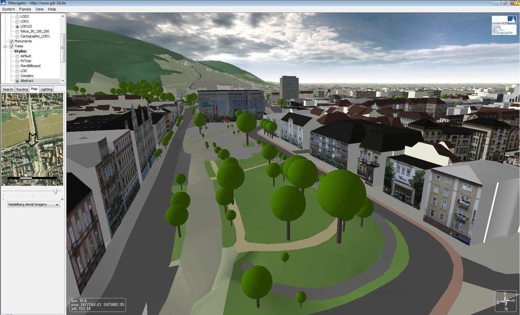
1 Putting GDI-3D into practice: Experiences from developing an 3D spatial data infrastructure based on OpenGIS standards for the sustainable management of urban areas Arne SCHILLING, Steffen NEUBAUER, Alexander ZIPF Germany Key words: 3D city models, OpenGIS, SDI, interoperability, service oriented architecture SUMMARY When someone wanted to publish 3D-city models on the internet, until recently there were only some proprietary digital globes or special solutions of a few companies available. But as the success of the OpenGIS WMS demonstrates, distributed solutions based on standardized web services provide an attractive alternative. The system described here tries to achieve this. The benefit of transmitting real 3D scenes instead of only pictures is evident (also known from typical virtual globes), as the 3D city models can be experienced interactively and also enriched with further information and applications when you actually need to work with the data. For example with such a solution data providers can integrate their own highly detailed digital elevation models. The main goal of the project GDI-3D (geo-spatial data infrastructure 3D) is to built and evaluate a complete 3D spatial data infrastructure (3D-SDI) based on OGC services. Such service oriented architectures (SOA) gain importance also for GI applications and in urban management. GDI-3D implements for the first time a whole set of relevant OpenGIS services and integrates those into a comprehensive web-based 3D application for an urban area. The fist testcase is the City of Heidelberg, Germany, but a range of other cities have shown interest and we have tested the system for much larger areas. The core of the system GDI-3D.de is one of the first implementations of the OpenGIS Web 3D (OGC W3DS) discussion paper. Within the OGC 3D Information Management (3DIM) working group a subgroup works on extending this towards becoming an OGC implementation specification together with some other aspects of 3D Portrayal. Our system comes with a free 3Dclient called <XNavigator>. This client is a Java WebStart-Application and will be installed automatically if you follow the respective URL and if Java 6 is already installed on the computer. XNavigator allows exploring and analysing the 3D city and landscaping models which are streamed by the W3DS server. A range of applications have been integrated in order to let the user work with the 3d model. In contrast to conventional proprietary 3D GIS the whole system is totally based on standards of the Open Geospatial Consortium (OGC). This ensures a maximum of flexibility of the architecture as you can insert or exchange standardized components realized as web services from arbitrary vendors quite easily. The system consists of the following OGC services which have either been implemented within the project or our research group (e.g. the OpenLS services) or are available as open source (such as WMS, WFS): - The W3DS (Web 3D ) itself as 3D portrayal service. It has its own 3D database and tools for generating optimized 3D models from raw data, including CityGML as import. - OpenLS Route (3D-Routing with height profile & animation routes also over bridges - Geocoder of the OGC OpenLS Utility (adress search and vice versa). - OpenGIS Web Processing (WPS). There are several WPS processes involved: for preprocessing of the geodata, as well as special analysis functions. Among others one WPS process also uses the 1/6
2 - OpenGIS Sensor Observation (SOS) for near real timeinformation from sensors (gauge levels, weather etc.). - OpenLS Directory, performs spatial queries for Points of Interest (POIs) and display them in 3D within our W3DS-Client XNavigator. The POIs have been imported from the OpenStreetMap data. They contain a variety of important and interesting locations like shops, ATMs, cafes, pharmacies, bus stops, hotels, night clubs, and many more. Currently over 50 categories are available within our service. The possible categories are unlimited and the data is being extended rapidly. The user can click on the 3D scene and search for specific types of locations within a selected radius. The result is shown as 3D labels. - Of course the system also includes the well known base components for SDIs, such as the * Web Map (WMS), (overview map) * Web Feature (WFS) (e.g. CityGML) * Catalogue (CS-W). Only shortly after CityGML became an official OGC standard it was also supported as import format for the GDI-3D technology. The CityGML data is being processed into an optimized 3D visualization format and stored in a special 3D geodatabase for efficient web-based visualization through streaming Further components will be added as the project proceeds (e.g. specialized WPS processes and other Sensor Web services). A special feature of the system is that the appearance of the 3D visualization can be controlled from the client through the OGC Symbology Encoding Specification. Similar to the well known WMS Styled Layer Descriptor (SLD) this approach allows realizing thematic cartography in 3D. One usage is to harmonize the look of data that comes from different server in one scene. An integrated SLDeditor allows doing this by the user on the fly. A range of visualization styles are already offered by the server. The 3D model has been generated in very close cooperation with the surveying office of the city of Heidelberg. Further content stems from other partners or has been digitized within the project itself. Most of the data has been generated from 2D data automatically. The system includes the complete set of buildings of the city of Heidelberg (~40.000) that can be accessed from the web. Further it features a 5 meter-dem, landuse, airborne photographs, street names and a range of other data such as historic flood areas, parking lots, laterns, street and traffic signs, trees and even a detailed model of the Virgin Mary that has been generated from terrestrial laser scan. A increasing set of important buildings and bridges have been modeled in higher detail and have textures. All data is preprocessed for efficient streaming and managed within a geodatabase. The goal of the project, that is funded by the Klaus-Tschira-Foundation in Heidelberg, is to develop new technologies and standards for the interoperable processing, visualization and analysis of 3D city and landscape models. The first version of the system will be developed further and has also already been tested successfully with 3D models of other cities. Further information, videos, screenshots, publications and the link for starting the actual online system can be found at: / 2/6


 Web Map 2D Maps")


3 Figures Catalogue Web Metadata for Data & s Map 3D Client Visualization Interaction Web Coverage Raster Data W3DS 3D City Models 3DDB Web Processing Pre-Processing Geo Data (DEM, 2D, 3D) Web Map 2D Maps (Overview) Web Feature Geo Database OpenLS Route 3D Route Calculations (on 3D Network) OpenLS Directory Yellow Pages OpenLS Utility Geocoder Web Processing Analytics (Emissions, Risk Assessment etc.) Sensor Observation Current Sensor Data 3/6

4 4/6
5 Project related publications: Hagedorn, B., Schilling, A., Neubauer, S., Zipf, A. (2008): 3D Portrayal s - Use Cases. Open Geospatial Consortium Discussion Paper (pending). OGC DocNr Walenciak, G., Stollberg, B., Neubauer, S. and Zipf, A. (2009): Extending Spatial Data Infrastructures 3D by Geoprocessing Functionality --3D Simulations in Disaster Management and environmental Research. The International Conference on Advanced Geographic Information Systems & Web s (GEOWS 2009). Cancun. Mexico. Schilling, A.; Lanig, S.; Neis, P.; Zipf, A. (2008): Integrating Terrain Surface and Street Network for 3D Routing. 3rd International Workshop on 3D Geo-Information. Seoul. South Korea. Goebel, R., Zipf, Al.(2008): How to define 3D Geoprocessing Operations for the OGC Web Processing. (WPS)? Towards a Classification of 3D Operations. International Workshop on Computational Geoinformatics. (CompGeo 2008). The 2008 International Conference on Computational Science and Its Applications (ICCSA 2008). Perugia. Italy. Lanig, S., Schilling, A., Stollberg, B., Zipf, A. (2008): Towards Standards-based Processing of Digital Elevation Models for Grid Computing through Web Processing (WPS). The 2008 International Conference on Computational Science and Its Applications (ICCSA 2008). Perugia. Italy. Zipf, A. (2008): Integrating 3D, Processing and Location s into future SDIs. GSDI_10. Tenth International Conference for Spatial Data Infrastructure. Port of Spain. Trinidad. Neis, P. and Zipf, A. (2008): Generating 3D Focus Maps for the (mobile) Web - an interoperable approach. In: International Journal of Location Based s (JLBS). Vol. 2, Issue 2. Nonn, U. and A. Zipf (2007): Metadata for 3D City Models - Analysis of the Applicability of the ISO Standard and Possibilities for further Amendments. AGILE International Conference on Geographic Information Science of the Association of Geograpic Information Laboratories for Europe (AGILE). Aalborg, Denmark. Neubauer, S., Zipf, A. (2007): Suggestions for Extending the OGC Styled Layer Descriptor (SLD) Specification into 3D â Towards Visualization Rules for 3D City Models, Urban Data Management Symposium. UDMS Stuttgart. Germany. Zipf, A., J. Basanow, P. Neis, S. Neubauer, A. Schilling (2007): Towards 3D Spatial Data Infrastructures (3D-SDI) based on Open Standards - experiences, results and future issues.. In: "3D GeoInfo07". ISPRS WG IV/8 International Workshop on 3D Geo-Information: Requirements, Acquisition, Modelling, Analysis, Visualisation. Delft, NETHERLANDS. Schilling, A., Basanow, J., Zipf, A. (2007): VECTOR BASED MAPPING OF POLYGONS ON IRREGULAR TERRAIN MESHES FOR WEB 3D MAP SERVICES. 3rd International Conference on Web Information Systems and Technologies (WEBIST). Barcelona, Spain. March Neis, P., A. Schilling, A. Zipf (2007): 3D Emergency Route (3D-ERS) based on OpenLS Specifications. GI4DM rd International Symposium on Geoinformation for Disaster Management. Toronto, Canada. 5/6
6 Personal Information: Prof. Dr. Alexander Zipf holds the Chair of Cartography at the Department of Geography at the University of Bonn. Before that he was Professor for Applied Computer Science and Geoinformatics at the Department of Geoinformatics and Surveying at the University of Applied Sciences FH Mainz. He did his PhD at the private research institute European Media Laboratory (EML) in Heidelberg in his project Deep Map after studying mathematics and geography at the University of Heidelberg, Germany. His research interests include a broad range of aspects of Geoinformatics, GIScience and Cartography from LBS to Web2.0, 3D SDI and ubiquitous GI services. Arne Schilling and Stefan Neubauer work in the research group of Alexander Zipf. Contact: Prof. Dr. Alexander Zipf Chair of Cartography University of Bonn / Department of Geography Meckenheimer Allee 172 (3.OG), Bonn, Germany 50 43' 32'' N / 7 05' 28'' E zipf@geographie.uni-bonn.de tel /6
How do Free and Open Geodata and Open Standards fit together?
 How do Free and Open Geodata and Open Standards fit together? From Sceptisim versus high Potential to real Applications. Michael Auer, Alexander Zipf University of Bonn, Department of Geography, Chair
Suggestions for Extending the OGC Styled Layer Descriptor (SLD) Specification into 3D Towards Visualization Rules for 3D City Models
 Specification into 3D Towards Visualization Rules for 3D City Models") Suggestions for Extending the OGC Styled Layer Descriptor (SLD) Specification into 3D Towards Visualization Rules for 3D City Models S. Neubauer University of Applied Sciences FH Mainz, Germany A. Zipf
Suggestions for Extending the OGC Styled Layer Descriptor (SLD) Specification into 3D Towards Visualization Rules for 3D City Models S. Neubauer University of Applied Sciences FH Mainz, Germany A. Zipf
Finding geodata that otherwise would have been forgotten GeoXchange a portal for free geodata
 Finding geodata that otherwise would have been forgotten GeoXchange a portal for free geodata Sven Tschirner and Alexander Zipf University of Applied Sciences FH Mainz Department of Geoinformatics and
European Spatial Data Research. EuroSDR. Prof. Dr. Ir. Joep Crompvoets. General Assembly CLGE Tirana 18 March
 EuroSDR Prof. Dr. Ir. Joep Crompvoets General Assembly CLGE - 2016 Tirana 18 March 2016 INTRODUCTORY QUESTIONS Who knows what is EuroSDR? Who does NOT know what is EuroSDR? Who is employed at mapping agencies?
Modern Education at Universities: Improvements through the Integration of a Spatial Data Infrastructure SDI into an e-learning Environment
 Modern Education at Universities: Improvements through the Integration of a Spatial Data Infrastructure SDI into an e-learning Environment Ingo Simonis Institute for Geoinformatics, University of Muenster
Pushing the Standards Edge: Collaborative Testbeds to Accelerate Standards Development and Implementation
 Pushing the Standards Edge: Collaborative Testbeds to Accelerate Standards Development and Implementation Mark E. Reichardt President mreichardt@opengeospatial.org 31 October 2006 2006 Open Geospatial
Geoinformation Science at TU Berlin
 Technische Universität Berlin Department of Geoinformation Science Geoinformation Science at TU Berlin Prof. Dr. Thomas H. Kolbe Institute for Geodesy and Geoinformation Science Berlin University of Technology
Imagery and the Location-enabled Platform in State and Local Government
 Imagery and the Location-enabled Platform in State and Local Government Fred Limp, Director, CAST Jim Farley, Vice President, Leica Geosystems Oracle Spatial Users Group Denver, March 10, 2005 TM TM Discussion
Implementing an online spatial database using the GRASS GIS environment
 Proceedings of the Open source GIS - GRASS users conference 2002 - Trento, Italy, 11-13 September 2002 Implementing an online spatial database using the GRASS GIS environment Venkatesh Raghavan*, Shinji
Open Contextual Cartographic Visualization
 J. Kozel 223 Open Contextual Cartographic Visualization Jiří Kozel Laboratory on Geoinformatics and Cartography, Insitute of Geography, Faculty of Science, Masaryk University, Czech Republic jirikozel@centrum.cz
7 11 August 2011, Vancouver. Don Brutzman, Benjamin Hagedorn. The OGC: Making Location Count
 OGC 3D Portrayal Interoperability Experiment, OGC 3D Summit 2011 SIGGRAPH 2011 7 11 August 2011, Vancouver Don Brutzman, Benjamin Hagedorn The OGC: Making Location Count What is the Open Geospatial Consortium?
IDEBarcelona: Cooperating for a Smart Region Infrastructure
 IDEBarcelona: Cooperating for a Smart Region Infrastructure Marta Codinachs Serra Diputació de Barcelona Territory and Sustainability Area Territorial Information Systems Department SMART CITY EXPO WORLD
GIS Building Communities beyond National Borders (Building Successful Spatial Data Infrastructures) Nick Land, ESRI Europe
 Nick Land, ESRI Europe") GIS Building Communities beyond National Borders (Building Successful Spatial Data Infrastructures) Nick Land, ESRI Europe UK worst flooding in the last 60 years 350,000 households without drinking water
GIS Building Communities beyond National Borders (Building Successful Spatial Data Infrastructures) Nick Land, ESRI Europe UK worst flooding in the last 60 years 350,000 households without drinking water
Using OGC standards to improve the common
 Using OGC standards to improve the common operational picture Abstract A "Common Operational Picture", or a, is a single identical display of relevant operational information shared by many users. The
SDI Standards at work
 SDI Standards at work Jan Juul Jensen Senior Technology Strategist Informi GIS Denmark Informi GIS Private held Limited Company Specialized in GIS 100+ employees HQ in Charlottenlund, Copenhagen Regional
<Insert Picture Here> Oracle Spatial 11g. Dr. Siva Ravada
 Oracle Spatial 11g Dr. Siva Ravada New in Oracle Spatial 11g 3D Support Spatial Web Services Network Data Model GeoRaster Performance Improvements 3D Applications Location-based services
Web 3D Service & CityGML Update
 Technische Universität Berlin Web 3D Service & CityGML Update Thomas H. Kolbe Institute for Geodesy and Geoinformation Science Berlin University of Technology kolbe@igg.tu-berlin.de 2nd of November, 2007
Overview of Geospatial Open Source Software which is Robust, Feature Rich and Standards Compliant
 Overview of Geospatial Open Source Software which is Robust, Feature Rich and Standards Compliant Cameron SHORTER, Australia Key words: Open Source Geospatial Foundation, OSGeo, Open Standards, Open Geospatial
Overview of CityGML. Dave Capstick, Ordnance Survey Research Department
 Overview of CityGML Dave Capstick, Ordnance Survey Research Department Introduction Why is citygml necessary CityGML development who is responsible? Ordnance Surveys interest 3D modelling basic concepts
GEOMATICS. Shaping our world. A company of
 GEOMATICS Shaping our world A company of OUR EXPERTISE Geomatics Geomatics plays a mayor role in hydropower, land and water resources, urban development, transport & mobility, renewable energy, and infrastructure
Spatial Data Infrastructure Concepts and Components. Douglas Nebert U.S. Federal Geographic Data Committee Secretariat
 Spatial Data Infrastructure Concepts and Components Douglas Nebert U.S. Federal Geographic Data Committee Secretariat August 2009 What is a Spatial Data Infrastructure (SDI)? The SDI provides a basis for
SITR-IDT The Spatial Data Infrastructure of Sardinia Region
 ITALY LOCAL AUTHORITY FOR MUNICIPALITIES, FINANCES AND URBAN PLANNING REGIONAL DEPARTMENT FOR CARTOGRAPHY AND INFORMATION SYSTEMS SITR-IDT The Spatial Data Infrastructure of Sardinia Region Content of
Sustainable and Harmonised Development for Smart Cities The Role of Geospatial Reference Data. Peter Creuzer
 Sustainable and Harmonised Development for Smart Cities The Role of Geospatial Reference Data Peter Creuzer 1. Introduction - Smart Cities and Geodata 2. Geodata in Germany 3. Examples 4. Data and Service
OGC 3D Portrayal Interoperability Experiment (3DPIE) Insights and Results
 Insights and Results") OGC 3D Portrayal Interoperability Experiment (3DPIE) Insights and Results Jan Klimke, Benjamin Hagedorn (Hasso-Plattner-Institut at the University Potsdam) Web 3D 2012 Los Angeles, August 4, 2012 Agenda
OGC 3D Portrayal Interoperability Experiment (3DPIE) Insights and Results Jan Klimke, Benjamin Hagedorn (Hasso-Plattner-Institut at the University Potsdam) Web 3D 2012 Los Angeles, August 4, 2012 Agenda
Local SDI Collaboration on SOA
 Institute of Geodesy Local SDI Collaboration on SOA Dr.-Ing. Jörg Blankenbach Dipl.-Ing. Christian Hickel FIG Commission 3 Workshop Paris, 27.10.2011 Agenda Local SDI in Hesse: GDI-Südhessen Overview Service
EuroSDR (European Spatial Data Research)
") EuroSDR (European Spatial Data Research) ROLLING RESEARCH PLAN 2015-2018 EuroSDR Secretariat Public Governance Institute KU Leuven Parkstraat 45 bus 3609 3000 Leuven Belgium Tel.: +32 16 32 31 80 Fax:
EuroSDR (European Spatial Data Research) ROLLING RESEARCH PLAN 2015-2018 EuroSDR Secretariat Public Governance Institute KU Leuven Parkstraat 45 bus 3609 3000 Leuven Belgium Tel.: +32 16 32 31 80 Fax:
Bentley Map V8i (SELECTseries 3)
") Bentley Map V8i (SELECTseries 3) A quick overview Why Bentley Map Viewing and editing of geospatial data from file based GIS formats, spatial databases and raster Assembling geospatial/non-geospatial data
Bentley Map V8i (SELECTseries 3) A quick overview Why Bentley Map Viewing and editing of geospatial data from file based GIS formats, spatial databases and raster Assembling geospatial/non-geospatial data
Discovery and Access of Geospatial Resources using the Geoportal Extension. Marten Hogeweg Geoportal Extension Product Manager
 Discovery and Access of Geospatial Resources using the Geoportal Extension Marten Hogeweg Geoportal Extension Product Manager DISCOVERY AND ACCESS USING THE GEOPORTAL EXTENSION Geospatial Data Is Very
WEB-BASED SPATIAL DECISION SUPPORT: TECHNICAL FOUNDATIONS AND APPLICATIONS
 WEB-BASED SPATIAL DECISION SUPPORT: TECHNICAL FOUNDATIONS AND APPLICATIONS Claus Rinner University of Muenster, Germany Piotr Jankowski San Diego State University, USA Keywords: geographic information
These modules are covered with a brief information and practical in ArcGIS Software and open source software also like QGIS, ILWIS.
 Online GIS Training and training modules covered are: 1. ArcGIS, Analysis, Fundamentals and Implementation 2. ArcGIS Web Data Sharing 3. ArcGIS for Desktop 4. ArcGIS for Server These modules are covered
GIS at UCAR. The evolution of NCAR s GIS Initiative. Olga Wilhelmi ESIG-NCAR Unidata Workshop 24 June, 2003
 GIS at UCAR The evolution of NCAR s GIS Initiative Olga Wilhelmi ESIG-NCAR Unidata Workshop 24 June, 2003 Why GIS? z z z z More questions about various climatological, meteorological, hydrological and
Experiences and Directions in National Portals"
 FIG Seminar on e-land Administration Innsbruck/Austria 2-4 June 2004 "ESRI's Experiences and Directions in National Portals" Kevin Daugherty Cadastral/Land Records Manager ESRI Topic Points Technology
ArcGIS Online Tools and Water-Related Web Services You Can Use Every Day of Your Life!
 ArcGIS Online Tools and Water-Related Web Services You Can Use Every Day of Your Life! Brian Rowley, PE, CFM FMA 2014 Annual Conference 1 Gold Rush (49ers) John Sutter Sutter s Mill South fork of American
Developing 3D Geoportal for Wilayah Persekutuan Iskandar
 Developing 3D Geoportal for Wilayah Persekutuan Iskandar Dionnald Beh BoonHeng and Alias Abdul Rahman Department of Geoinformatics, Faculty of Geoinformation Engineering and Sciences, Universiti Teknologi
Modular Web Framework for the BRANDENBURGVIEWER
 Modular Web Framework for the BRANDENBURGVIEWER Geoinformation System (GIS) 2 GIS = geo + information + system + + Survey of data Organization of data Processing and Analysis Presentation geodata infrastructure
E-Government and SDI in Bavaria, Germany
 135 E-Government and SDI in Bavaria, Germany Wolfgang STOESSEL, Germany Key words: GDI-BY, Bavaria, Spatial Data Infrastructure SUMMARY Spatial Data Infrastructure (SDI) is an important part of the e-government
PaikkaOppi - a Virtual Learning Environment on Geographic Information for Upper Secondary School
 PaikkaOppi - a Virtual Learning Environment on Geographic Information for Upper Secondary School Jaakko Kähkönen*, Lassi Lehto*, Juha Riihelä** * Finnish Geodetic Institute, PO Box 15, FI-02431 Masala,
Introduction to geoprocessing services using SEXTANTE. Víctor Olaya SEXTANTE Geospatial Services
 Introduction to geoprocessing services using SEXTANTE. Víctor Olaya SEXTANTE Geospatial Services Overview Quick introduction to SEXTANTE Client/Server fundamentals Standards for web-based geoservices SEXTANTE
Basics of GIS reviewed
 Basics of GIS reviewed Martin Breunig Karlsruhe Institute of Technology martin.breunig@kit.edu GEODETIC INSTITUTE, DEPARTMENT OF CIVIL ENGINEERING, GEO AND ENVIRONMENTAL SCIENCES, CHAIR IN GEOINFORMATICS
Roadmap to interoperability of geoinformation
 Roadmap to interoperability of geoinformation and services in Europe Paul Smits, Alessandro Annoni European Commission Joint Research Centre Institute for Environment and Sustainability paul.smits@jrc.it
Hosted by Esri Official Distributor
 Hosted by Esri Official Distributor Esri European User Conference October 15-17, 2012 Oslo, Norway Hosted by Esri Official Distributor Interoperability and Standards Support in ArcGIS 10.1 Roberto Lucchi
Esri s Living Atlas of the World Community Maps
 Esri s Living Atlas of the World Community Maps Seth Sarakaitis Wednesday May 7, 2014 ArcGIS Living Atlas Concept Living Atlas Content Tour Contributing to the Living Atlas (Community Maps) Seth Sarakaitis
GIS-based Smart Campus System using 3D Modeling
 GIS-based Smart Campus System using 3D Modeling Hardik Panchal & Rizwan Khan, Smita Sengupta, GISE Advance Lab, Indian Institute of Technology, Bombay, India N.L. Sarda, Dept. Of Computer Science, Indian
ISO Series Standards in a Model Driven Architecture for Landmanagement. Jürgen Ebbinghaus, AED-SICAD
 ISO 19100 Series Standards in a Model Driven Architecture for Landmanagement Jürgen Ebbinghaus, AED-SICAD 29.10.2003 The Company 100% SIEMENS PTD SIEMENS Business Services Shareholder & Strategic Business
3D-SDI contribution to energy-efficient cities 3D CityModels for Energy Demand Simulation
 HFT Research 3D-SDI contribution to energy-efficient cities 3D CityModels for Energy Demand Simulation Claudia Schulte, HFT Stuttgart, Institute for Applied Research Prof. Dr. Volker Coors, HFT Stuttgart,
USING GIS CARTOGRAPHIC MODELING TO ANALYSIS SPATIAL DISTRIBUTION OF LANDSLIDE SENSITIVE AREAS IN YANGMINGSHAN NATIONAL PARK, TAIWAN
 CO-145 USING GIS CARTOGRAPHIC MODELING TO ANALYSIS SPATIAL DISTRIBUTION OF LANDSLIDE SENSITIVE AREAS IN YANGMINGSHAN NATIONAL PARK, TAIWAN DING Y.C. Chinese Culture University., TAIPEI, TAIWAN, PROVINCE
Portals: Standards in Action
 Portals: Standards in Action David Danko ISO TC 211 Metadata Project Leader GIS Standards Consultant-ESRI. Metadata Portals Portal gateway, place of entry Producers Advertise, expose products Share information
INSPIREd solutions for Air Quality problems Alexander Kotsev
 INSPIREd solutions for Air Quality problems Alexander Kotsev www.jrc.ec.europa.eu Serving society Stimulating innovation Supporting legislation The European data puzzle The European data puzzle 24 official
Norwegian spatial data infrastructure supporting disaster risk management Norwegian Mapping Authority
 Norwegian spatial data infrastructure supporting disaster risk management Norwegian Mapping Authority Arvid Lillethun, Norwegian Mapping Authority Land and Poverty 2018 Conference, World Bank 19.-23. March
Methodological Chain for Hydrological Management with Web-GIS Applications
 Advances in Geosciences Konstantinos Perakis & Athanasios Moysiadis, Editors EARSeL, 2012 Methodological Chain for Hydrological Management with Web-GIS Applications Alexandros Konstantinidis 1, Eleni Tzanou
3D MAPS SCALE, ACCURACY, LEVEL OF DETAIL
 26 th International Cartographic Conference August 25 30, 2013 Dresden, Germany 3D MAPS SCALE, ACCURACY, LEVEL OF DETAIL Prof. Dr. Temenoujka BANDROVA Eng. Stefan BONCHEV University of Architecture, Civil
Innovation. The Push and Pull at ESRI. September Kevin Daugherty Cadastral/Land Records Industry Solutions Manager
 Innovation The Push and Pull at ESRI September 2004 Kevin Daugherty Cadastral/Land Records Industry Solutions Manager The Push and The Pull The Push is the information technology that drives research and
Data Aggregation with InfraWorks and ArcGIS for Visualization, Analysis, and Planning
 Data Aggregation with InfraWorks and ArcGIS for Visualization, Analysis, and Planning Stephen Brockwell President, Brockwell IT Consulting, Inc. Join the conversation #AU2017 KEYWORD Class Summary Silos
Geospatial Products V8i (SELECTseries 1)
") Geospatial Products V8i (SELECTseries 1) Keith Raymond Product Manager Geospatial Desktop Products Presentation Overview What are the various products? Why would you need them? Demonstrations 2 WWW.BENTLEY.COM
Geospatial Products V8i (SELECTseries 1) Keith Raymond Product Manager Geospatial Desktop Products Presentation Overview What are the various products? Why would you need them? Demonstrations 2 WWW.BENTLEY.COM
EXPECTATIONS OF TURKISH ENVIRONMENTAL SECTOR FROM INSPIRE
 EXPECTATIONS OF TURKISH ENVIRONMENTAL SECTOR FROM INSPIRE June, 2010 Ahmet ÇİVİ Tuncay DEMİR INSPIRE in the Eyes of MoEF Handling of Geodata by MoEF Benefits Expected TEIEN First Steps for INSPIRE Final
How does ArcGIS Server integrate into an Enterprise Environment? Willy Lynch Mining Industry Specialist ESRI, Denver, Colorado USA
 How does ArcGIS Server integrate into an Enterprise Environment? Willy Lynch Mining Industry Specialist ESRI, Denver, Colorado USA wlynch@esri.com ArcGIS Server Technology Transfer 1 Agenda Who is ESRI?
reviewed paper EU-Project: Cross-border Spatial Information System with High Added Value (CROSS-SIS) Stefan SANDMANN
 Stefan SANDMANN") reviewed paper EU-Project: Cross-border Spatial Information System with High Added Value (CROSS-SIS) Stefan SANDMANN Surveying and Mapping Agency NRW, Bonn, Muffendorfer Str. 19-21, Germany, sandman@lverma.nrw.de
reviewed paper EU-Project: Cross-border Spatial Information System with High Added Value (CROSS-SIS) Stefan SANDMANN Surveying and Mapping Agency NRW, Bonn, Muffendorfer Str. 19-21, Germany, sandman@lverma.nrw.de
A Spatial Data Infrastructure for Landslides and Floods in Italy
 V Convegno Nazionale del Gruppo GIT Grottaminarda 14 16 giugno 2010 A Spatial Data Infrastructure for Landslides and Floods in Italy Ivan Marchesini, Vinicio Balducci, Gabriele Tonelli, Mauro Rossi, Fausto
IRDAT Fvg, evolving a regional Spatial Data Infrastructure according to INSPIRE
 IRDAT Fvg, evolving a regional Spatial Data Infrastructure according to INSPIRE Tutti i diritti riservati. Proprietà INSIEL SpA. A. Benvenuti, A. Chiarandini Insiel (Italy) M. Lunardis - Friuli Venezia
CES Seminar 2016: Geospatial information services based on official statistics Key issues from the session II papers
 Norbert Rainer 64 th plenary session of the Conference of European Statisticians 28 April 2016, Paris CES Seminar 2016: Geospatial information services based on official statistics Key issues from the
Metadata for 3D City Models. Analysis of the Applicability of the ISO Standard and Possibilities for further Amendments
 Page 1 of 9 Metadata for 3D City Models Analysis of the Applicability of the ISO 19115 Standard and Possibilities for further Amendments Leonhard Dietze, Ulrike Nonn, Alexander Zipf University of Applied
Overview. Everywhere. Over everything.
 Cadenza Desktop Cadenza Web Cadenza Mobile Cadenza Overview. Everywhere. Over everything. The ultimate GIS and reporting suite. Provide, analyze and report data efficiently. For desktop, web and mobile.
One platform for desktop, web and mobile
 One platform for desktop, web and mobile Search and filter Get access to all data thematically filter data in context factually and spatially as well as display it dynamically. Export a selection or send
SITMUN: Cooperating to Build Local SDIs in the Barcelona Region
 SITMUN: Cooperating to Build Local SDIs in the Barcelona Region Diputació de Barcelona Territory and Sustainability Area Territorial Information Systems Department INSPIRE CONFERENCE Barcelona, September
Canadian Board of Examiners for Professional Surveyors Core Syllabus Item C 5: GEOSPATIAL INFORMATION SYSTEMS
 Study Guide: Canadian Board of Examiners for Professional Surveyors Core Syllabus Item C 5: GEOSPATIAL INFORMATION SYSTEMS This guide presents some study questions with specific referral to the essential
ArcGIS. for Server. Understanding our World
 ArcGIS for Server Understanding our World ArcGIS for Server Create, Distribute, and Manage GIS Services You can use ArcGIS for Server to create services from your mapping and geographic information system
GSDI Global Spatial Data Infrastructure. Convergences between Geo Spatial Communities: key decision for decision making
 GSDI Global Spatial Data Infrastructure Convergences between Geo Spatial Communities: key decision for decision making April 14 th 2010 Bas Kok GSDI Past-President Director of International Affairs, Dutch
Technical Specifications. Form of the standard
 Used by popular acceptance Voluntary Implementation Mandatory Legally enforced Technical Specifications Conventions Guidelines Form of the standard Restrictive Information System Structures Contents Values
Karsten Vennemann, Seattle. QGIS Workshop CUGOS Spring Fling 2015
 Karsten Vennemann, Seattle 2015 a very capable and flexible Desktop GIS QGIS QGIS Karsten Workshop Vennemann, Seattle slide 2 of 13 QGIS - Desktop GIS originally a GIS viewing environment QGIS for the
OGC Standards Update 29 November 2018 Orlando
 OGC Standards Update 29 November 2018 Orlando Mark Reichardt mreichardt@opengeospatial.org +1 301 840-1361 OGC S INTEREST It s simple You have this or this and you need to make this... or this Courtesy
Regional Spatial Data Infrastructures What Makes them Possible?
 Article for Geoinformatics June 2007 Regional Spatial Data Infrastructures What Makes them Possible? by Sam Bacharach Executive Director Outreach Open Geospatial Consortium, Inc. (OGC) INTRODUCTION The
GIS for 3D Object Generation, Modelling, and Exploitation. Paul Hardy Esri
 GIS for 3D Object Generation, Modelling, and Exploitation Paul Hardy Esri ArcGIS has long understood 3D Multipatch data type in geodatabase - 3D volumetric objects - Collection of triangles, strips, fans,
Digital Map of Mexico Platform and MxSIG. March 2017
 Digital Map of Mexico Platform and MxSIG March 2017 1 I. Digital Map of Mexico Platform Concept Evolution II. Digital Map of Mexico online Concept Capabilities Information available Other state units information
3D Portrayal Interoperability Experiment
 3D Portrayal Interoperability Experiment Benjamin Hagedorn Computergraphische Systeme Hasso-Plattner-Institut an der Universität Potsdam Workshop 3D-Stadtmodelle 2011 Bonn, 9. November 2011 OGC & 3DIM
On the convergence of 3D-GIS, CAD and 3D Simulation
 On the convergence of 3D-GIS, CAD and 3D Simulation V. Coors, Stuttgart University of Applied Science, Volker.Coors@hft-stuttgart.de Urban information space Due to improved tools for the design and acquisition
ADDING METADATA TO MAPS AND STYLED LAYERS TO IMPROVE MAP EFFICIENCY
 ADDING METADATA TO MAPS AND STYLED LAYERS TO IMPROVE MAP EFFICIENCY B. Bucher, S. Mustière, L. Jolivet, J. Renard IGN-COGIT, Saint Mandé, France Introduction Standard APIs to visualise geodata on information
A Vision for ArcGIS Applying Geography Everywhere
 A Vision for ArcGIS Applying Geography Everywhere WELCOME PURPOSE A Network of GIS Professionals Are Awakening the World to the Power of Web GIS You Your WORK Making a Difference Your Work Open Maps and
A decade of geoinformation sharing at ETH Zurich
 A decade of geoinformation sharing at ETH Zurich Ionuț Iosifescu-Enescu, Cristina Iosifescu-Enescu, Nadia H. Panchaud, Angeliki Tsorlini, Lorenz Hurni {iosifescu,ciosifescu,nadia.panchaud,atsorlini,lhurni}@ethz.ch
Reprint of article that appeared in Hydro INTERNATIONAL November 2006 Volume 10 Issue 9
 Reprint of article that appeared in Hydro INTERNATIONAL November 2006 Volume 10 Issue 9 While Google Earth is the best known 3D web-mapping viewer currently in the public domain, there are alternative
Global 3D Models with Local Content
 Gunnar Misund Associate Professor Head of Environmental Computing gunnar.misund@hiof.no - Morten Granlund, Scientfic Assistant Herman Kolås, Master Student Mats Lindh, Master Student - Østfold University
CARTOGRAPHY in a Web World
 CARTOGRAPHY in a Web World SENSE Research Cluster XIII meeting: Concepts and tools for spatial data visualization BAREND KÖBBEN kobben@itc.nl b.j.kobben@utwente.nl Agenda Short introduction to ITC and
Massachusetts Institute of Technology Department of Urban Studies and Planning
 Massachusetts Institute of Technology Department of Urban Studies and Planning 11.520: A Workshop on Geographic Information Systems 11.188: Urban Planning and Social Science Laboratory GIS Principles &
Spatially Enabled Society
 International Seminar on Land Administration Trends and Issues in Asia and the Pacific Region Spatially Enabled Society Abbas Rajabifard Vice Chair PCGIAP-WG3 Vice-President (President Elect), GSDI Association
VISUALIZING THE SMART CITY 3D SPATIAL INFRASTRUCTURE GEOSMART ASIA- 30 SEP, 2015
 www.aamgroup.com VISUALIZING THE SMART CITY 3D SPATIAL INFRASTRUCTURE GEOSMART ASIA- 30 SEP, 2015 Agenda AAM What is a Smart City? Data Acquisition 3D Modelling Benefits Questions AAM AAM is a Geospatial
NSDI Policy Framework of Japan - Roles of the Private Sector in SDI -
 NSDI Policy Framework of Japan - Roles of the Private Sector in SDI - Hiroshi Murakami (GSI) Geospatial World Forum 2012 Amsterdam Background Survey Act (1949) mandates the (GSI) to develop and provide
OGC and GSDI: A Partnership in Advancing SDI Best Practices
 OGC and GSDI: A Partnership in Advancing SDI Best Practices GSDI 11 Workshop 1.4 SDI Challenges 15 June 2009 Mark Reichardt President and CEO mreichardt@opengeospatial.org +1 301 840-1361 Copyright 2009,
Features and Benefits
 Autodesk LandXplorer Features and Benefits Use the Autodesk LandXplorer software family to help improve decision making, lower costs, view and share changes, and avoid the expense of creating physical
UN-GGIM Arab States Meeting Welcome Address. Denise McKenzie Open Geospatial Consortium 21 February 2017 Doha, Qatar
 UN-GGIM Arab States Meeting Welcome Address Denise McKenzie Open Geospatial Consortium 21 February 2017 Doha, Qatar The Open Geospatial Consortium Not-for-profit, international voluntary consensus standards
Oman NSDI Supporting Economic Development. Saud Al-Nofli Director of Spatial Data Directorate General of NSDI, NCSI
 Oman NSDI Supporting Economic Development 2017 Saud Al-Nofli Director of Spatial Data Directorate General of NSDI, NCSI "It s critical to make correct decisions the first time to optimize the Investments
Introduction to ArcGIS Server - Creating and Using GIS Services. Mark Ho Instructor Washington, DC
 Introduction to ArcGIS Server - Creating and Using GIS Services Mark Ho Instructor Washington, DC Technical Workshop Road Map Product overview Building server applications GIS services Developer Help resources
Mark E Reichardt. President & CEO Open Geospatial Consortium
 Mark E Reichardt President & CEO Open Geospatial Consortium mreichardt@myogc.org Agenda 0900-0915 Welcome and Introduction - Topic setting (Chair) 0915-0935 Ron Bloksma, The next step is interoperability
NOKIS - Information Infrastructure for the North and Baltic Sea
 NOKIS - Information Infrastructure for the North and Baltic Sea Carsten Heidmann 1 and Jörn Kohlus 2 Abstract 1. General The initial motivation for the project NOKIS (German title: Nord- und Ostsee-Küsteninformationssystem)
Building a National Data Repository
 Building a National Data Repository Mladen Stojic, Vice President - Geospatial 1/30/2013 2012 Intergraph Corporation 1 Information has meaning and gives power only when shared and distributed. Information,
Increasing GI awareness in local authorities in Poland experiences from the INSPIRE Academy training programme
 Increasing GI awareness in local authorities in Poland experiences from the INSPIRE Academy training programme http://www.akademiainspire.pl Maria Andrzejewska, Monika Rusztecka UNEP/GRID-Warsaw Centre,
Paper UC1351. Conference: User Conference Date: 08/10/2006 Time: 8:30am-9:45am Room: Room 23-B (SDCC)
") Conference: User Conference Date: 08/10/2006 Time: 8:30am-9:45am Room: Room 23-B (SDCC) Title of Paper: Increasing the Use of GIS in the Federal Government Author Name: Miss Abstract This presentation
Conference: User Conference Date: 08/10/2006 Time: 8:30am-9:45am Room: Room 23-B (SDCC) Title of Paper: Increasing the Use of GIS in the Federal Government Author Name: Miss Abstract This presentation
Institute of Statistical and Geographical Information of Jalisco State Subnational Statistical and Geographical System India.
 Institute of Statistical and Geographical Information of Jalisco State Subnational Statistical and Geographical System India. January 2017 Subnational Statistical and Geographical System National Statistical
Compact guides GISCO. Geographic information system of the Commission
 Compact guides GISCO Geographic information system of the Commission What is GISCO? GISCO, the Geographic Information System of the COmmission, is a permanent service of Eurostat that fulfils the requirements
Business Model for sustainable regional development by tourism
 Business Model for sustainable regional development by tourism Why EuroVeloPark Banat? Steps to Success Action proposal 1. Drawing of the Basis Map 2. Data Acquisition, POIs, etc. 3. Printed Map and Distribution
UBGI and Address Standards
 Workshop on address standards UBGI and Address Standards 2008. 5.25 Copenhagen, Denmark Sang-Ki Hong Convenor, WG 10 1 Evolution of Geographic Information Visualization Feature (Contents) Context Accessibility
A Model of GIS Interoperability Based on JavaRMI
 A Model of GIS Interoperability Based on Java Gao Gang-yi 1 Chen Hai-bo 2 1 Zhejiang University of Finance & Economics, Hangzhou 310018, China 2 College of Computer Science and Technology, Zhejiang UniversityHangzhou