OGC 3D Portrayal Interoperability Experiment (3DPIE) Insights and Results
|
|
|
- Luke Montgomery
- 6 years ago
- Views:
Transcription
 Insights and Results Jan Klimke,")
 Web 3D 2012 Los Angeles,")
1 OGC 3D Portrayal Interoperability Experiment (3DPIE) Insights and Results Jan Klimke, Benjamin Hagedorn (Hasso-Plattner-Institut at the University Potsdam) Web 3D 2012 Los Angeles, August 4, 2012
2 Agenda Introduction OGC 3DIM 3D PIE 3D Portrayal Services Experiments Results
3 OGC 3D Information Management (3DIM) Domain Working Group Overview Background A great deal of technical innovation has been accomplished in the areas of CAD, AEC, geospatial, 3D visualization, and urban simulation. A variety of products, information and services abound in each of these environments. A framework of data interoperability should exist across the lifecycle of building and infrastructure investment: planning, design, construction, operation, and decommissioning. This work is of interest to the geospatial community in that there is a growing need for technologies and information to effectively interoperate between these domains to support a range of vital services and decision support needs. The working group was formed in 2005 to identify and act on opportunities to improve interoperability of geospatial data and services across these domains.
4 3DIM DWG History Formed as CAD/GIS Domain Working Group Initiated CityGML Standards Working Group 3D Portrayal Interoperability Experiment (3DPIE) CAD/GIS/BIM-Thread in OGC Web Services Initiative Phase 4 (OWS-4) Changed name to 3D Information Management Domain Working Group in 2007 to better reflect the diversity of work in the group Initiated Oblique Imagery Domain Working Group IndoorGML Standards Working Group

5 3DIM DWG Activities Forum and incubator for 3D-related topics Devise Architecture for open interop. 3D services Advance Discussion Papers and Best Practices Participate in Testbeds Build on industry Partnerships
 Development of IFC, the major open standard for Building Information Modeling (BIM) AECOO-1 Testbed: OGC Discussion Paper released BIM-GIS Information Exchange Project")
6 3DIM DWG - Relationships 3DIM relationships include, e.g., buildingsmart alliance (MoU) Development of IFC, the major open standard for Building Information Modeling (BIM) AECOO-1 Testbed: OGC Discussion Paper released BIM-GIS Information Exchange Project Special Interest Group 3D (MoU) German organization resp. for initial CityGML format Web 3D Consortium (MoU) X3D: ISO standard for 3D graphics on the Web W3C Point of Interest Working Group Mission is to develop a technical specification for the representation of "Points of Interest" information on the Web
 3D at the OGC An")

7 OGC Domain Working Groups (Aug-8-11) 3D at the OGC An interest or focus in 3D content modeling, sharing, and integration/fusion
8 OGC 3D Data Standards OGC Geography Markup Language XML-based language for encoding geographic information to be stored and transported over the Internet Defines both the 2D and 3D geometry and properties of objects that comprise geographic information. CityGML Format Application independent geospatial information model and exchange format for 3D city models comprising different thematic areas (buildings, vegetation, water, terrain, traffic etc.) and dimensions KML Encoding Standard XML for geographic visualization on 2D and 3D Earth browsers Ex. of display features: placemarks, images, polygons, 3D models

9 Other 3D Data Formats and Standards Collada (Collaborative Design Activity) Model and Format for 3D graphics data Developed and managed by the Khronos Group X3D (Extensible 3D Graphics Format) Successor of VRML; ISO standard for 3D graphics data Geospatial support through various GeoNodes Developed and managed by Web 3D Consortium X3DOM Approach for the integration of HTML5 and declarative 3D content Integrates X3D elements as part of HTML5 DOM tree Currently developed by Fraunhofer IGD

10 CityGML application- independent NOT only for visualization object-oriented information model + geo data exchange format CityGML 4 LODs Levels-of-Detail, e.g., simple blocks to indoor models semantics topology 3D geometry multidimensional thematic data appearance
 to test, demonstrate, and bring forward different approaches and standards for service-based.")
11 3DPIE In mid 2011, the OGC 3DIM Working Group initialized and launched the OGC 3D Portrayal Interoperability Experiment (3DPIE) to test, demonstrate, and bring forward different approaches and standards for service-based...
12 3DPIE Portrayal presentation of information to humans [ISO 19117]
13 3DPIE Missing Link: Open Services for 3D Portrayal Proprietary 3D portrayal solutions available for Perspective Street Views, Virtual Globes (commercial and open source) However, extensibility and interoperability are limited and projects (e.g. 3D City Models) depend on the business model of existing platforms By opening the 3D portrayal interfaces it becomes possible to exchange servers and clients in a flexible way Service based 3D visualization systems have different requirements than full desktop GIS

14 3DPIE We need a Map Server for 3D


15 3DPIE Participants Fraunhofer IGD GIScience at University Heidelberg Hasso-Plattner-Institut at University Potsdam Bitmanagement CACI IGG at Technical University Berlin Institute Geographic Nationale (IGN) LSIS at Aix-Marseille University MOVES at the Naval Post Graduate School Virginia Tech

16 3D Portrayal Services Separation of rendering concerns; examples of services and formats: Google Earth X3D Viewer GML CityGML KML X3D SLD for WMS DP DP WVS WFS W3DS WMS


17 3D Portrayal Services Web 3D Service and Web View Service


 can be")
18 OGC Candidate Standard: Web 3D Service Web-based, Graphics-Based Provision of and Access to Virtual 3D Worlds Geodata is delivered as scenes that are comprised of display elements, optimized for efficient real time rendering at high frame rates It can be used for web applications and datasets that are too big for being stored in single files. Streaming allows effective fly-throughs. All features supported by web 3D standards (VRML, X3D, COLLADA, KML) can be exploited.


19 OGC Candidate Standard: Web View Service Web-based, Image-Based Provision of and Access to Virtual 3D Worlds Server-side model management and 3D rendering Generation of images of views on the 3D model and transfer to viewer clients Provides visual, thematic, and geometric information as images Reduces data complexity and rendering complexity for clients WVS is a 3D equivalent of 2D map services

20 3DPIE Focus Main focus on Web 3D Service and Web View Service Can the WVS and W3DS adequately support the web-based management, portrayal, and exploration of urban 3D geodata? Can the W3DS and WVS specifications be further harmonized to provide a more common interface to 3D portrayal capabilities and to support their potential integration and combination? What are best practices for the application of the various 3D portrayal approaches, including graphics-based 3D portrayal through W3DS and image-based 3D portrayal through WVS? What are best practices for the application of the various 3D geodata formats and 3D graphics data formats including CityGML, X3D, KML, COLLADA, and others? How to exploit W3DS and WVS from various client platforms, including thin-clients, web-based clients, and mobile clients?


21 Architecture 3DPIE Architecture #4A/B Website showing 3D content CityGML Datasets #1A 3D Database W3DS Server #3 #2 W3DS Client Application Other Datasets #1B 3D Database WVS Client Application WVS Server #5A/B Mobile Apps WI-1: Data Integration WI-2: Service Integration WI-3: Service Delivery
22 3DPIE Datasets Paris LARGE Mainz Berlin textured buildings, terrain OSM Blacksburg CityGML/X3D LOD1/2
23 3DPIE Servers and Clients OSM Data OSM-3D W3DS VRML, X3D, KML, KMZ/Collada Mainz Data (CityGML) IGD CityServer3D W3DS KML, Collada, X3D, HTML5 Berlin Data (CityGML) IGG 3DCityDB W3DS KML, Collada Paris 3D (CityGML) HPI 3D Server WVS Images (Color/Depth/ObjectIds)
24 3DPIE Servers and Clients OSM Data OSM-3D (W3DS) XNavigator Mainz Data (CityGML) Berlin Data (CityGML) Paris 3D (CityGML) IGD CityServer3D (W3DS) IGG 3DCityDB (W3DS) HPI 3D Server (WVS) Newly implemented Connections HTML5 Browser Instant Reality Player Google Earth BS Contact Geo, BS Contact Mobile HPI Mobile Client
25 Data integration 3DPIE Experiment Activities Importing Paris data into IGG Web 3D Service Importing Berlin data into IGG Web 3D Service Importing Mainz data into CityServer3D Importing Paris data into CityServer3D Importing Paris data into HPI Web View Service Importing OpenStreetMap data into OSM-3D Web 3D Service Service Integration + Service Delivery Displaying KML from W3DS in Google Earth Accessing X3D Merging data from multiple Web 3D Services in XNavigator Merging 3D models from W3DS and imagery from WVS in XNavigator Sharing and displaying WVS imagery in web browsers Displaying WVS imagery on mobile clients Rendering CityGML data in the web browser Rendering W3DS data in the web browser Rendering W3DS data on mobile devices Extended LOD concept for X3D


26 Result Examples W3DS in Google Earth Integrated W3DS client W3DS for Web and Mobile WVS for Web and Mobile W3DS + WVS

")

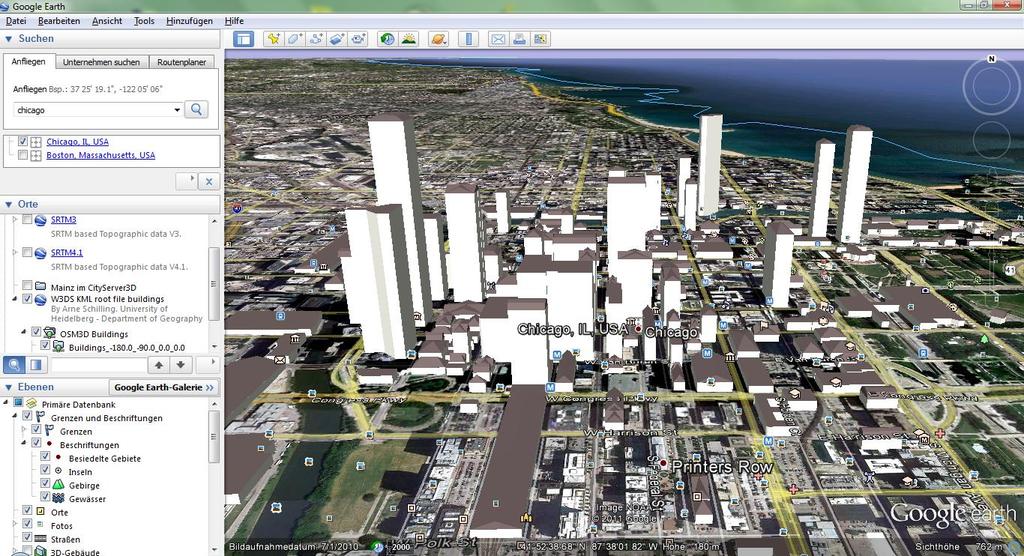
27 Results: W3DS in Google Earth (1) OSM-3D W3DS in Google Earth
 to Google")
28 Results: W3DS in Google Earth (2) IGG s W3DS serves Paris data (from CityGML) to Google Earth

 + Mainz- W3DS")
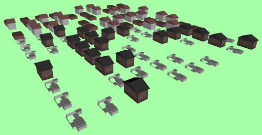
29 Results: Multiple W3DS in an integrated client Integrating data from OSM-3D (textured terrain) + Mainz- W3DS (building model)


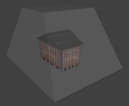
30 Results: W3DS for Web and Mobile Fraunhofer s X3DOM City Viewer in the Web browser and on mobile device


31 Results: WVS for Web and Mobile HPI s WVS serves Paris city model to a web and mobile client

32 Results: Combining W3DS + WVS


33 Other Experiments Virginia Tech: Advanced Levelof-Detail mechanism for X3D Bitmanagement: Rendering CityGML and X3D in the Browser LSIS: CityGML for the Web
34 Results: Web-based Rendering of CityGML Experiments on serving CityGML and JSON and rendering in the borwser based on WebGL W3DS-like approach

35 Results: Using W3DS in BS Contact Geo


36 Results: Advanced LOD mechanism for X3D Optimized distance computation for LOD3/LOD4-transitions based on a bounding prism
37 ... some more details WVS W3DS 3DPIE
38 Web View Service (WVS) Approach A WVS renders and provides G-Buffers (color, depth, object-ids, normals, etc) to a consumer WVS provides additional service operations for navigation, feature data retrieval, and analysis (GetPosition, GetFeatureInfo, GetMeasurement, GetCamera) Major Characteristics of Service-Based 3D Rendering Complexity of the transferred G-buffers is independent from original 3D scene's complexity 3D rendering takes place in controlled server environment No specialized 3D hardware or software required at the client side Web-based access is provided, while original 3D content is kept protected


39 Importer HPI3D Server Overview Service interface, images WVS Client Scalability, CPU/GPU parallel WVS Interface Supporting massive, complex models Styling according to application, task, user 3D Rendering Engine Parallel Processing Out-of-Core Rendering Styling Space/time efficient transmission Image Encoding Massive data (CityGML, 3DS, dae, shp, dxf, VRML,...) HPI 3D Server


40 WVS Preprocessing massive 3D geodata Conversion of 3D geodata to an efficiently renderable scene graph representation CityGML Semantics Geometry Appearance 1 1. Data Extraction Feature Extraction Geometry Triangulation Object-Id Assignment Spatial Organisation 2. Geometry Optimization Geometry Batching Serialization Texture Optimization Texture Atlas Computation MipMap Generation Texture Coordinate Adjustment


41 HPI3D Web-Client Lightweight JavaScript-Based Web Client displays mainly images retrieved from the WVS
42 HPI3D Mobile Client Real-Time 3D Viewer Client Creating the illusion of a 3D environment by partial reconstruction of the scene from a cubemap retrieved from WVS


43 HPI3D Mobile Client Real-Time 3D Viewer Client Creating the illusion of a 3D environment by partial reconstruction of the scene from a cubemap retrieved from WVS Method 1: 3D illusion by placing the virtual 3D camera in a textured cube that is created and rendered at the client side


44 HPI3D Mobile Client Real-Time 3D Viewer Client Creating the illusion of a 3D environment by partial reconstruction of the scene from a cubemap retrieved from WVS Method 1: 3D illusion by placing the virtual 3D camera in a textured cube that is created and rendered at the client side Method 2: Client-side reconstruction and rendering of a textured 3D mesh from the retrieved depth information 2D depth information 3D mesh geometry
45 HPI3D Mobile Client Demo
46 Delivery of 3D Graphics Data (W3DS) Approaches for delivering 3D Graphics Data 1. Integrated 3D clients consume services capability documents 2. 3D Viewer clients receive a master file that contains valid service getdata requests (file-based integration/combination) 1. W3DS Capabilities url 2. Master file Integrated Client Capabilities url Viewer Client W3DS

 Suitable Formats X3D with Geo-Extension KML/COLLADA")
47 Delivery of 3D Graphics Data (W3DS) 3D Graphics Formats must support High precision Geo-coordinates Group nodes and transformation matrices View or distance dependent rendering (LOD) Possibility to represent Icons/placemarks and labels (Inlining / loading remote data via URLs) Suitable Formats X3D with Geo-Extension KML/COLLADA combination
48 Generating and Displaying KML W3DS delivery to Google Earth Google Earth does not understand W3DS (or WVS) syntax no plugin, no content negotiation In order to support GE, a root KML file must be created NetworkLink elements are used for dynamic loading of 3D content from service Approaches: 1.Additional Service Operation GetTileDefinition provides KML including all NetworkLinks using GetScene requests 2.GetScene request generates KML including NetworkLinks pointing directly to resources 3.A root KML is provided. Quadtree is generated recursively using GetScene requests.

 yes Tile too big?")

49 Root KML file provides Quadtree Structure Root KML with 4 Network Links GetScene OSM-3D W3DS Google Earth KML with 4 Network Links (W3DS Requests) yes Tile too big? Refine Tiles / Iteration through Quadtree KMZ Archive with 4 COLLADA Models Tile Size > MaxScaleDenominator no
 Group of 4 COLLADA Models contained in KMZ Archive")
50 Root KML file provides Quadtree Structure Pure KMZ/KML with NetworkLinks (KMZ/KML Requests) KMZ Archive with NetworkLinks (COLLADA Requests) Group of 4 COLLADA Models contained in KMZ Archive


51 W3DS based on 3D CityGML Database Exported Building Models Import Google Earth IGG W3DS 3DCityDB (CityGML Database Oracle Spatial)

52 Overall 3DPIE Results Successful test and demonstration of how to set up 3D portrayal pipelines based on open formats and services for various client platforms and devices Identification of challenges and solutions, e.g., for serving large 3D city models or dealing with height references Identification of potential changes for the W3DS and WVS specification 3DPIE Report to be made publicly available

53 Next Steps for 3DPIE/3DIM


54 Thank you for your attention! Thank you for your Attention. Jan Klimke, Benjamin Hagedorn Hasso-Plattner-Institut at the University Potsdam OGC 3D Information Management Working Group OGC 3D Portrayal Interoperability Experiment
7 11 August 2011, Vancouver. Don Brutzman, Benjamin Hagedorn. The OGC: Making Location Count
 OGC 3D Portrayal Interoperability Experiment, OGC 3D Summit 2011 SIGGRAPH 2011 7 11 August 2011, Vancouver Don Brutzman, Benjamin Hagedorn The OGC: Making Location Count What is the Open Geospatial Consortium?
3D Portrayal Interoperability Experiment
 3D Portrayal Interoperability Experiment Benjamin Hagedorn Computergraphische Systeme Hasso-Plattner-Institut an der Universität Potsdam Workshop 3D-Stadtmodelle 2011 Bonn, 9. November 2011 OGC & 3DIM
GIS-based Smart Campus System using 3D Modeling
 GIS-based Smart Campus System using 3D Modeling Smita Sengupta GISE Advance Research Lab. IIT Bombay, Powai Mumbai 400 076, India smitas@cse.iitb.ac.in Concept of Smart Campus System Overview of IITB Campus
Developing 3D Geoportal for Wilayah Persekutuan Iskandar
 Developing 3D Geoportal for Wilayah Persekutuan Iskandar Dionnald Beh BoonHeng and Alias Abdul Rahman Department of Geoinformatics, Faculty of Geoinformation Engineering and Sciences, Universiti Teknologi
Web 3D Service & CityGML Update
 Technische Universität Berlin Web 3D Service & CityGML Update Thomas H. Kolbe Institute for Geodesy and Geoinformation Science Berlin University of Technology kolbe@igg.tu-berlin.de 2nd of November, 2007
Features and Benefits
 Autodesk LandXplorer Features and Benefits Use the Autodesk LandXplorer software family to help improve decision making, lower costs, view and share changes, and avoid the expense of creating physical
Generating and Caching 3D-Tiles for Large-Scale 3D-Visualization GeoSharing , Bern, Switzerland
 Generating and Caching 3D-Tiles for Large-Scale 3D-Visualization GeoSharing 02.11.2013, Bern, Switzerland Martin Christen, Robert Wüest, Benjamin Loesch, Stephan Nebiker FHNW University of Applied Sciences
Pushing the Standards Edge: Collaborative Testbeds to Accelerate Standards Development and Implementation
 Pushing the Standards Edge: Collaborative Testbeds to Accelerate Standards Development and Implementation Mark E. Reichardt President mreichardt@opengeospatial.org 31 October 2006 2006 Open Geospatial
GIS-based Smart Campus System using 3D Modeling
 GIS-based Smart Campus System using 3D Modeling Hardik Panchal & Rizwan Khan, Smita Sengupta, GISE Advance Lab, Indian Institute of Technology, Bombay, India N.L. Sarda, Dept. Of Computer Science, Indian
Web-based Exploration of and Interaction with Large and Deeply Structured Semantic 3D City Models using HTML5 and WebGL
 Web-based Exploration of and Interaction with Large and Deeply Structured Semantic 3D City Models using HTML5 and WebGL KANISHK CHATURVEDI 1, ZHIHANG YAO 2 & THOMAS H. KOLBE 1 Abstract: The aim of the
OGC Standards Update 29 November 2018 Orlando
 OGC Standards Update 29 November 2018 Orlando Mark Reichardt mreichardt@opengeospatial.org +1 301 840-1361 OGC S INTEREST It s simple You have this or this and you need to make this... or this Courtesy
Data Conversion to I3S for 3D Modeling from CityGML. Christian Dahmen (con terra GmbH) Satish Sankaran (Esri)
 Satish Sankaran (Esri)") Data Conversion to I3S for 3D Modeling from CityGML Christian Dahmen (con terra GmbH) Satish Sankaran (Esri) 3D Across the ArcGIS Platform Manage Multiscale 3D Models 3D Geodesign ArcGIS for 3D Cities
Data Conversion to I3S for 3D Modeling from CityGML Christian Dahmen (con terra GmbH) Satish Sankaran (Esri) 3D Across the ArcGIS Platform Manage Multiscale 3D Models 3D Geodesign ArcGIS for 3D Cities
Overview of CityGML. Dave Capstick, Ordnance Survey Research Department
 Overview of CityGML Dave Capstick, Ordnance Survey Research Department Introduction Why is citygml necessary CityGML development who is responsible? Ordnance Surveys interest 3D modelling basic concepts
INTEROPERABLE VISUALIZATION OF 3D CITY MODELS USING OGC S STANDARD 3D PORTRAYAL SERVICE
 INTEROPERABLE VISUALIZATION OF 3D CITY MODELS USING OGC S STANDARD 3D PORTRAYAL SERVICE A. Koukofikis 1, V. Coors 1, R. Gutbell 2 1 Hochschule für Technik Stuttgart, Faculty Geomatics, Computer Science
Global 3D Models with Local Content
 Gunnar Misund Associate Professor Head of Environmental Computing gunnar.misund@hiof.no - Morten Granlund, Scientfic Assistant Herman Kolås, Master Student Mats Lindh, Master Student - Østfold University
Web Visualization of Geo-Spatial Data using SVG and VRML/X3D
 Web Visualization of Geo-Spatial Data using SVG and VRML/X3D Jianghui Ying Falls Church, VA 22043, USA jying@vt.edu Denis Gračanin Blacksburg, VA 24061, USA gracanin@vt.edu Chang-Tien Lu Falls Church,
Questions and Answers
 AUTODESK LANDXPLORER SOFTWARE FAMILY Questions and Answers The Autodesk LandXplorer 3D city model software family can help you create, analyze, and visualize digital city models. Contents Autodesk Landxplorer
Overview of Geospatial Open Source Software which is Robust, Feature Rich and Standards Compliant
 Overview of Geospatial Open Source Software which is Robust, Feature Rich and Standards Compliant Cameron SHORTER, Australia Key words: Open Source Geospatial Foundation, OSGeo, Open Standards, Open Geospatial
Open Geospatial Consortium
 Open Geospatial Consortium Approval Date: 2012-06-23 Publication Date: 2012-08-27 External identifier of this OGC docu ment: http://www.opengis.net/doc/ie/3dpie Reference number of this document: OGC 12-075
I. Pispidikis *, E. Dimopoulou
 DEVELOPMENT OF A 3D WEBGIS SYSTEM FOR RETRIEVING AND VISUALIZING CITYGML DATA BASED ON THEIR GEOMETRIC AND SEMANTIC CHARACTERISTICS BY USING FREE AND OPEN SOURCE TECHNOLOGY I. Pispidikis *, E. Dimopoulou
WEB-BASED SPATIAL DECISION SUPPORT: TECHNICAL FOUNDATIONS AND APPLICATIONS
 WEB-BASED SPATIAL DECISION SUPPORT: TECHNICAL FOUNDATIONS AND APPLICATIONS Claus Rinner University of Muenster, Germany Piotr Jankowski San Diego State University, USA Keywords: geographic information
Bentley Map Advancing GIS for the World s Infrastructure
 Bentley Map Advancing GIS for the World s Infrastructure Presentation Overview Why would you need Bentley Map? What is Bentley Map? Where is Bentley Map Used? Why would you need Bentley Map? Because your
Semantic 3D City Models for Strategic Energy Planning in Berlin & London
 Semantic 3D City Models for Strategic Energy Planning in Berlin & London The content of this presentation is provided by Zhihang Yao, Robert Kaden, and Thomas H. Kolbe Chair of Geoinformatics, TU München
Spatial Data Infrastructure Concepts and Components. Douglas Nebert U.S. Federal Geographic Data Committee Secretariat
 Spatial Data Infrastructure Concepts and Components Douglas Nebert U.S. Federal Geographic Data Committee Secretariat August 2009 What is a Spatial Data Infrastructure (SDI)? The SDI provides a basis for
Geoprovisioning delivers geodata and its analysis for specific areas on request.
 DRAFT 27 February 2009 Geoprovisioning Geoprovisioning delivers geodata and its analysis for specific areas on request. What are the components of a geoprovisioning service? The sample web site geoprovisioning.com
Geospatial Products V8i (SELECTseries 1)
") Geospatial Products V8i (SELECTseries 1) Keith Raymond Product Manager Geospatial Desktop Products Presentation Overview What are the various products? Why would you need them? Demonstrations 2 WWW.BENTLEY.COM
Geospatial Products V8i (SELECTseries 1) Keith Raymond Product Manager Geospatial Desktop Products Presentation Overview What are the various products? Why would you need them? Demonstrations 2 WWW.BENTLEY.COM
Integrating Building Information Models with Open Geospatial Web Services
 Open Geospatial Consortium Interoperability Testbed 4 for CAD/GIS/BIM Integrating Building Information Models with Open Geospatial Web Services Prepared by: Paul Cote Harvard Graduate School of Design
Imagery and the Location-enabled Platform in State and Local Government
 Imagery and the Location-enabled Platform in State and Local Government Fred Limp, Director, CAST Jim Farley, Vice President, Leica Geosystems Oracle Spatial Users Group Denver, March 10, 2005 TM TM Discussion
Geo-Enabling Digital India. 15 th Esri India User Conference GIS and Smart Cities
 15 th Esri India User Conference 2014 GIS and Smart Cities 15 th Esri India User Conference 2014 GIS and Smart Cities Agendra Kumar President, Esri India Our World Is Facing Serious Challenges Our World
OpenGeospatial Consortium Working Group Reports 3DIM, Urban planning, Land & Infrastructure
 OpenGeospatial Consortium Working Group Reports 3DIM, Urban planning, Land & Infrastructure Leif Granholm BIM Ambassador, Trimble October 30, 2014 Toronto 3DIM Charter The 3D Information Management (3DIM)
Arne SCHILLING, Steffen NEUBAUER, Alexander ZIPF Germany. Key words: 3D city models, OpenGIS, SDI, interoperability, service oriented architecture
 Putting GDI-3D into practice: Experiences from developing an 3D spatial data infrastructure based on OpenGIS standards for the sustainable management of urban areas Arne SCHILLING, Steffen NEUBAUER, Alexander
A Vision for ArcGIS Applying Geography Everywhere
 A Vision for ArcGIS Applying Geography Everywhere WELCOME PURPOSE A Network of GIS Professionals Are Awakening the World to the Power of Web GIS You Your WORK Making a Difference Your Work Open Maps and
<Insert Picture Here> Oracle Spatial 11g. Dr. Siva Ravada
 Oracle Spatial 11g Dr. Siva Ravada New in Oracle Spatial 11g 3D Support Spatial Web Services Network Data Model GeoRaster Performance Improvements 3D Applications Location-based services
Discovery and Access of Geospatial Resources using the Geoportal Extension. Marten Hogeweg Geoportal Extension Product Manager
 Discovery and Access of Geospatial Resources using the Geoportal Extension Marten Hogeweg Geoportal Extension Product Manager DISCOVERY AND ACCESS USING THE GEOPORTAL EXTENSION Geospatial Data Is Very
New Methods for GeoDesign with ArcGIS and CityEngine. Dr. Özgür Ertac, Prof. Dr. Jörg Schaller, Cristina Mattos Tech. Uni. Munich, Esri Germany
 New Methods for GeoDesign with ArcGIS and CityEngine Dr. Özgür Ertac, Prof. Dr. Jörg Schaller, Cristina Mattos Tech. Uni. Munich, Esri Germany Agenda Evolution in 3D Introduction 3D Across the ArcGIS Platform
CityGML in Detail Part 2
 CityGML in Detail Part 2 Prof. Dr. Thomas H. Kolbe Institute for Geodesy and Geoinformation Science Berlin University of Technology kolbe@igg.tu-berlin.de May 2008 EduServ6 Course on CityGML Copyright
PaikkaOppi - a Virtual Learning Environment on Geographic Information for Upper Secondary School
 PaikkaOppi - a Virtual Learning Environment on Geographic Information for Upper Secondary School Jaakko Kähkönen*, Lassi Lehto*, Juha Riihelä** * Finnish Geodetic Institute, PO Box 15, FI-02431 Masala,
Virtual Cities of the Future and Past. Paul Cote Geographic Information Systems Specialist Harvard University Graduate School of Design
 Virtual Cities of the Future and Past Paul Cote Geographic Information Systems Specialist Harvard University Graduate School of Design 500 Design Students 250 Architecture 50 Urban Planning 100 Urban Design
ArcGIS is Advancing. Both Contributing and Integrating many new Innovations. IoT. Smart Mapping. Smart Devices Advanced Analytics
 ArcGIS is Advancing IoT Smart Devices Advanced Analytics Smart Mapping Real-Time Faster Computing Web Services Crowdsourcing Sensor Networks Both Contributing and Integrating many new Innovations ArcGIS
COLLADA BOF Siggraph 2012 Neil Trevett, NVIDIA, Khronos President Fabrice Robinet, Motorola Mobility, COLLADA Chair
 COLLADA BOF Siggraph 2012 Neil Trevett, NVIDIA, Khronos President Fabrice Robinet, Motorola Mobility, COLLADA Chair Copyright Khronos Group 2012 Page 1 Copyright Khronos Group 2012 Page 2 Welcome! Update
Mark E Reichardt. President & CEO Open Geospatial Consortium
 Mark E Reichardt President & CEO Open Geospatial Consortium mreichardt@myogc.org Agenda 0900-0915 Welcome and Introduction - Topic setting (Chair) 0915-0935 Ron Bloksma, The next step is interoperability
Using OGC standards to improve the common
 Using OGC standards to improve the common operational picture Abstract A "Common Operational Picture", or a, is a single identical display of relevant operational information shared by many users. The
Paper UC1351. Conference: User Conference Date: 08/10/2006 Time: 8:30am-9:45am Room: Room 23-B (SDCC)
") Conference: User Conference Date: 08/10/2006 Time: 8:30am-9:45am Room: Room 23-B (SDCC) Title of Paper: Increasing the Use of GIS in the Federal Government Author Name: Miss Abstract This presentation
Conference: User Conference Date: 08/10/2006 Time: 8:30am-9:45am Room: Room 23-B (SDCC) Title of Paper: Increasing the Use of GIS in the Federal Government Author Name: Miss Abstract This presentation
Leveraging the OGC Capabilities of ArcGIS Server
 Leveraging the OGC Capabilities of ArcGIS Server Satish Sankaran Interoperability and Standards Team Yingqi Tang Server Team Jessica Parteno Geodatabase Team ArcGIS Server is Open & Interoperable Using
Making interoperability persistent: A 3D geo database based on CityGML
 Making interoperability persistent: A 3D geo database based on CityGML Alexandra Stadler, Claus Nagel, Gerhard König, Thomas H. Kolbe Technische Universität Berlin Chair of Geoinformation Science Motivation
Hosted by Esri Official Distributor
 Hosted by Esri Official Distributor Esri European User Conference October 15-17, 2012 Oslo, Norway Hosted by Esri Official Distributor Interoperability and Standards Support in ArcGIS 10.1 Roberto Lucchi
What you always wanted to know about the OGC Programs, Process, Participation
 What you always wanted to know about the OGC Programs, Process, Participation UNIGIS International u_lecture, 25. March 2014 https://www3.gotomeeting.com/register/909498390 Dipl.-Geogr. Athina Trakas Open
CityGML 3D Geospatial and Semantic Modelling of Urban Structures
 Technische Universität Berlin CityGML 3D Geospatial and Semantic Modelling of Urban Structures Prof. Dr. Thomas H. Kolbe Institute for Geodesy and Geoinformation Science Berlin University of Technology
Implementing INSPIRE Geoportal in Turkey
 Implementing INSPIRE Geoportal in Turkey Gencay SERTER City and Regional Planner 1 Presentation Plan Introduction INSPIRE and Turkey Importance of al Spatial Planning Portal Logical&Legal Hierarchy GeoPortal
Compression Techniques for 3D SDI
 Compression Techniques for 3D SDI Bernad S. ChengXi and Alias Abdul Rahman 3D GIS Research Lab Faculty of Geoinformation and Real Estate Universiti Teknologi Malaysia Outline Introduction Background of
3-1 Data Standardiza5on
 ITS488 Geographic Informa5on System 3-1 Data Standardiza5on 2014 08 26 Teerayut Horanont, PhD Sirindhorn Interna5onal Ins5tute of Technology (SIIT) Thammasat University E: teerayut@siit.tu.ac.th Part of
OGC GEOPACKAGE AND HOW OPEN SOURCE IS CHANGING THE WAY GOVERNMENTS THINK ABOUT STANDARDS. Nathan Frantz Geospatial Research Lab
 OGC GEOPACKAGE AND HOW OPEN SOURCE IS CHANGING THE WAY GOVERNMENTS THINK ABOUT STANDARDS Nathan Frantz Geospatial Research Lab Dr. Ben Tuttle National Geospatial-Intelligence Agency FOSS4G 2015 Geospatial
BIM Building Information Modelling/Management
 1 BIM Building Information Modelling/Management Outline What is the Industry Foundation Classes? Background Schema Domains What is the Information Delivery Manual? 2 Managing Data Requirements The Information
ArcGIS. for Server. Understanding our World
 ArcGIS for Server Understanding our World ArcGIS for Server Create, Distribute, and Manage GIS Services You can use ArcGIS for Server to create services from your mapping and geographic information system
Web-Based 3D Geospatial Facility Model Data Interfaces
 Web-Based 3D Geospatial Facility Model Interfaces Federal Facilities Council Symposia October 31, 2006 BIM: Grass Root Experiences Alex Viana Naval Facilities Engineering Command Washington Navy Yard,
How does ArcGIS Server integrate into an Enterprise Environment? Willy Lynch Mining Industry Specialist ESRI, Denver, Colorado USA
 How does ArcGIS Server integrate into an Enterprise Environment? Willy Lynch Mining Industry Specialist ESRI, Denver, Colorado USA wlynch@esri.com ArcGIS Server Technology Transfer 1 Agenda Who is ESRI?
Innovation. The Push and Pull at ESRI. September Kevin Daugherty Cadastral/Land Records Industry Solutions Manager
 Innovation The Push and Pull at ESRI September 2004 Kevin Daugherty Cadastral/Land Records Industry Solutions Manager The Push and The Pull The Push is the information technology that drives research and
3D City GIS. Agenda. Why 3D City GIS? What does 3D City GIS mean?
 3D City GIS 1 of 60 WWW.BENTLEY.COM Ben Fredericque, Product Manager, Geospatial Agenda Why 3D City GIS? What does 3D City GIS mean? 2 of 60 WWW.BENTLEY.COM Sydney, Australia, 11 16 April 2010 1 Why 3D
Semantic Evolution of Geospatial Web Services: Use Cases and Experiments in the Geospatial Semantic Web
 Semantic Evolution of Geospatial Web Services: Use Cases and Experiments in the Geospatial Semantic Web Joshua Lieberman, Todd Pehle, Mike Dean Traverse Technologies, Inc., Northrop Grumman Information
Why GIS & Why Internet GIS?
 Why GIS & Why Internet GIS? The Internet bandwagon Internet mapping (e.g., MapQuest) Location-based services Real-time navigation (e.g., traffic) Real-time service dispatch Business Intelligence Spatial
Geospatial Standards Support - An Overview. Marten Hogeweg & Satish Sankaran
 Geospatial Standards Support - An Overview Marten Hogeweg & Satish Sankaran Agenda Interoperability and Standards ArcGIS Open, Interoperable and Standards Compliant Esri Open initiatives Understanding
Key Points Sharing fosters participation and collaboration Metadata has a big role in sharing Sharing is not always easy
 Sharing Resources Geoff Mortson esri, Inc. SDI Solutions Team Key Points Sharing fosters participation and collaboration Metadata has a big role in sharing Sharing is not always easy Data Sharing is Good
Bentley Map Advancing GIS for the World s Infrastructure
 Bentley Map Advancing GIS for the World s Infrastructure Presentation Overview Why would you need Bentley Map? What is Bentley Map? Where is Bentley Map Used? Red text signifies new things in Bentley Map
CARTOGRAPHY in a Web World
 CARTOGRAPHY in a Web World SENSE Research Cluster XIII meeting: Concepts and tools for spatial data visualization BAREND KÖBBEN kobben@itc.nl b.j.kobben@utwente.nl Agenda Short introduction to ITC and
ArcGIS Earth for Enterprises DARRON PUSTAM ARCGIS EARTH CHRIS ANDREWS 3D
 ArcGIS Earth for Enterprises DARRON PUSTAM ARCGIS EARTH CHRIS ANDREWS 3D ArcGIS Earth is ArcGIS Earth is a lightweight globe desktop application that helps you explore any part of the world and investigate
Charter for the. Information Transfer and Services Architecture Focus Group
 for the Information Transfer and Services Architecture Focus Group 1. PURPOSE 1.1. The purpose of this charter is to establish the Information Transfer and Services Architecture Focus Group (ITSAFG) as
CARTOGRAPHY in a Web World
 CARTOGRAPHY in a Web World Nationale GI Minor BAREND KÖBBEN b.j.kobben@utwente.nl Agenda Short introduction to ITC and me Cartography: communicating spatial data Changing GIS & Cartography technology:
ISO Series Standards in a Model Driven Architecture for Landmanagement. Jürgen Ebbinghaus, AED-SICAD
 ISO 19100 Series Standards in a Model Driven Architecture for Landmanagement Jürgen Ebbinghaus, AED-SICAD 29.10.2003 The Company 100% SIEMENS PTD SIEMENS Business Services Shareholder & Strategic Business
Cadastral Standards & Interoperability
 Cadastral Standards & Interoperability Some Considerations Black Hills Digital Mapping Association September 18, 2007 Jeanne Foust ESRI Spatial Data Infrastructure Global Manager jfoust@esri.com Why is
Multimodal Location Based Services Semantic 3D City Data as Virtual and Augmented Reality
 Multimodal Location Based Services Semantic 3D City Data as Virtual and Augmented Reality José Miguel Santana Agustín Trujillo José Pablo Suárez Jochen Wendel Alexander Simons Andreas Koch Collaboration
ArcGIS Enterprise: What s New. Philip Heede Shannon Kalisky Melanie Summers Sam Williamson
 ArcGIS Enterprise: What s New Philip Heede Shannon Kalisky Melanie Summers Sam Williamson ArcGIS Enterprise is the new name for ArcGIS for Server What is ArcGIS Enterprise ArcGIS Enterprise is powerful
Introduction to ArcGIS Server Development
 Introduction to ArcGIS Server Development Kevin Deege,, Rob Burke, Kelly Hutchins, and Sathya Prasad ESRI Developer Summit 2008 1 Schedule Introduction to ArcGIS Server Rob and Kevin Questions Break 2:15
CARTOGRAPHIC WEB SERVICES AND CARTOGRAPHIC RULES A NEW APPROACH FOR WEB CARTOGRAPHY
 CARTOGRAPHIC WEB SERVICES AND CARTOGRAPHIC RULES A NEW APPROACH FOR WEB CARTOGRAPHY 1. Introduction Ionut Iosifescu, Marco Hugentobler, Lorenz Hurni ETH Zurich, Institute of Cartography Wolfgang-Pauli-Str.
Perform. Xcel. Lead. Presenter. Raghavendran S. GM Technical (GIS)
") Perform. Xcel. Lead. Presenter Raghavendran S GM Technical (GIS) Perform. Xcel. Lead. The Trademarks/Logos belong to the respective companies 2015 PIXEL SOFTEK PVT. LTD. 1 Incorporated in 1996 HQ in Bangalore,
Perform. Xcel. Lead. Presenter Raghavendran S GM Technical (GIS) Perform. Xcel. Lead. The Trademarks/Logos belong to the respective companies 2015 PIXEL SOFTEK PVT. LTD. 1 Incorporated in 1996 HQ in Bangalore,
Reprint of article that appeared in Hydro INTERNATIONAL November 2006 Volume 10 Issue 9
 Reprint of article that appeared in Hydro INTERNATIONAL November 2006 Volume 10 Issue 9 While Google Earth is the best known 3D web-mapping viewer currently in the public domain, there are alternative
UBGI and Address Standards
 Workshop on address standards UBGI and Address Standards 2008. 5.25 Copenhagen, Denmark Sang-Ki Hong Convenor, WG 10 1 Evolution of Geographic Information Visualization Feature (Contents) Context Accessibility
These modules are covered with a brief information and practical in ArcGIS Software and open source software also like QGIS, ILWIS.
 Online GIS Training and training modules covered are: 1. ArcGIS, Analysis, Fundamentals and Implementation 2. ArcGIS Web Data Sharing 3. ArcGIS for Desktop 4. ArcGIS for Server These modules are covered
SDI Standards at work
 SDI Standards at work Jan Juul Jensen Senior Technology Strategist Informi GIS Denmark Informi GIS Private held Limited Company Specialized in GIS 100+ employees HQ in Charlottenlund, Copenhagen Regional
The (Rough) road to BIM- Geospatial standards. Leif Granholm BIM ambassador
 road to BIM- Geospatial standards. Leif Granholm BIM ambassador") The (Rough) road to BIM- Geospatial standards Leif Granholm BIM ambassador What is Structured Semantic data BIM Graphics to objects Drawings geometry are graphics (appearance important) A Model consists
The (Rough) road to BIM- Geospatial standards Leif Granholm BIM ambassador What is Structured Semantic data BIM Graphics to objects Drawings geometry are graphics (appearance important) A Model consists
ESRI Survey Summit August Clint Brown Director of ESRI Software Products
 ESRI Survey Summit August 2006 Clint Brown Director of ESRI Software Products Cadastral Fabric How does Cadastral fit with Survey? Surveyors process raw field observations Survey measurements define high-order
3D Urban Information Models in making a smart city the i-scope project case study
 UDC: 007:528.9]:004; 007:912]:004; 004.92 DOI: 10.14438/gn.2014.17 Typology: 1.04 Professional Article 3D Urban Information Models in making a smart city the i-scope project case study Dragutin PROTIĆ
Enabling ENVI. ArcGIS for Server
 Enabling ENVI throughh ArcGIS for Server 1 Imagery: A Unique and Valuable Source of Data Imagery is not just a base map, but a layer of rich information that can address problems faced by GIS users. >
THE SPATIAL DATA SERVER BASED ON OPEN GIS STANDARDS IN HETEROGENEOUS DISTRIBUTED ENVIRONMENT
 Geoinformatics 2004 Proc. 12th Int. Conf. on Geoinformatics Geospatial Information Research: Bridging the Pacific and Atlantic University of Gävle, Sweden, 7-9 June 2004 THE SPATIAL DATA SERVER BASED ON
You are Building Your Organization s Geographic Knowledge
 You are Building Your Organization s Geographic Knowledge And Increasingly Making it Available Sharing Data Publishing Maps and Geo-Apps Developing Collaborative Approaches Citizens Knowledge Workers Analysts
WEB MAP SERVICE (WMS) FOR GEOLOGICAL DATA GEORGE TUDOR
 FOR GEOLOGICAL DATA GEORGE TUDOR") WEB MAP SERVICE (WMS) FOR GEOLOGICAL DATA GEORGE TUDOR WEB MAP SERVICE (WMS) - GENERALITIES Projects with data from different sources Geological data are in different GIS software format Large amount of
WEB MAP SERVICE (WMS) FOR GEOLOGICAL DATA GEORGE TUDOR WEB MAP SERVICE (WMS) - GENERALITIES Projects with data from different sources Geological data are in different GIS software format Large amount of
ArcGIS Earth an Intro
 ArcGIS Earth an Intro Chris Andrews Product Manager, 3D and ArcGIS Earth Brian Sims 3D Content Lead 3D across the Esri product family ArcGIS Pro 3D Analyst CityEngine ArcGIS for Server ArcGIS Online ArcGIS
Health DWG ad-hoc. May 31 st, 2013 OGC-TC
 Health DWG ad-hoc May 31 st, 2013 OGC-TC AGENDA 1. Welcome / Roundtable Introductions 2. Background of OGC and proposal of Health DWG 3. Toward an OGC Health DWG 4. Draft Health DWG Charter 5. Potential
Strategies for Integrating CAD and BIM in ArcGIS. Don Kuehne Esri 3D Product Manager: CAD/BIM/AEC
 Strategies for Integrating CAD and BIM in ArcGIS Don Kuehne Esri 3D Product Manager: CAD/BIM/AEC CAD Digital Drawing CAD in ArcGIS Desktop CAD in Desktop CAD as Data CAD as a Map EXPORT TO CAD Create and
A Technique for Importing Shapefile to Mobile Device in a Distributed System Environment.
 A Technique for Importing Shapefile to Mobile Device in a Distributed System Environment. 1 Manish Srivastava, 2 Atul Verma, 3 Kanika Gupta 1 Academy of Business Engineering and Sciences,Ghaziabad, 201001,India
Framework for on an open 3D urban analysis platform based on OGC Web Services
 Platzhalter für Bild, Bild auf Titelfolie hinter das Logo einsetzen Framework for on an open 3D urban analysis platform based on OGC Web Services Marc-O. Löwner & Thomas Adolphi (née Becker) Technische
Bentley Map V8i (SELECTseries 3)
") Bentley Map V8i (SELECTseries 3) A quick overview Why Bentley Map Viewing and editing of geospatial data from file based GIS formats, spatial databases and raster Assembling geospatial/non-geospatial data
Bentley Map V8i (SELECTseries 3) A quick overview Why Bentley Map Viewing and editing of geospatial data from file based GIS formats, spatial databases and raster Assembling geospatial/non-geospatial data
A Geographer s role in a Google Maps World. Jeremy Bartley ESRI
 A Geographer s role in a Google Maps World Jeremy Bartley ESRI 1 It is a good time to be a Geographer. 2 Microsoft, Google, Yahoo, and others are pushing geographic awareness to the general public Providing
Extension of Electronical Nautical Charts for 3D interactive Visualization via CityGML
 Extension of Electronical Nautical Charts for 3D interactive Visualization via CityGML Kristine HAASE und Reinhard KOCH Multimedia Information Processing Group, Department of Computer Science Christian-Albrechts-University
Magnetar Games Corporation
 'The higher we soar the smaller we appear to those who cannot fly.. Friedrich Nietzsche Magnetar Games Corporation Magnetar Multiverse Highlights! Standards based virtual alternate reality authoring and
What is GIS and How Can It Help Me?
 esri European User Conference Madrid 2011 What is GIS and How Can It Help Me? Jaime Nieves Ignacio Vázquez esri spain «Knowing where things are, and why, is essential to rational decision making.» Jack
ArcGIS Enterprise: What s New. Philip Heede Shannon Kalisky Melanie Summers Shreyas Shinde
 ArcGIS Enterprise: What s New Philip Heede Shannon Kalisky Melanie Summers Shreyas Shinde ArcGIS Enterprise is the new name for ArcGIS for Server ArcGIS Enterprise Software Components ArcGIS Server Portal
Spatial data interoperability and INSPIRE compliance the platform approach BAGIS
 Spatial data interoperability and INSPIRE compliance the platform approach BAGIS BAGIS Voluntary, independent, public, non-profit organization; Organization with main mission to promote the growth of the
GEOSPATIAL WEB SERVICE INTEGRATION AND MASHUPS FOR WATER RESOURCE APPLICATIONS
 GEOSPATIAL WEB SERVICE INTEGRATION AND MASHUPS FOR WATER RESOURCE APPLICATIONS C. Granell a, *, L. Díaz a, M. Gould a a Center for Interactive Visualization, Department of Information Systems, Universitat
Data Aggregation with InfraWorks and ArcGIS for Visualization, Analysis, and Planning
 Data Aggregation with InfraWorks and ArcGIS for Visualization, Analysis, and Planning Stephen Brockwell President, Brockwell IT Consulting, Inc. Join the conversation #AU2017 KEYWORD Class Summary Silos
What is CERA? Coastal Emergency Risks Assessment
 What is CERA? Coastal Emergency Risks Assessment Visualization tool using OGC standards Displays the outputs from the ADCIRC storm surge model or other coastal models Represents the maps on interactive