BIM Building Information Modelling/Management
|
|
|
- Augusta West
- 6 years ago
- Views:
Transcription
1 1 BIM Building Information Modelling/Management
2 Outline What is the Industry Foundation Classes? Background Schema Domains What is the Information Delivery Manual? 2
3 Managing Data Requirements The Information Delivery Manual (IDM) was developed as a direct response to the challenge of defining data requirements to meet BLC processes. It has been developed by buildingsmart Together with Model View Definitions (MVDs), they provide a methodology for different domain experts to model the specific data requirements that are needed to meet their own use cases.
4 The Information Delivery Manual The IDM/MVD methodology defines how to specify business use cases and how to coordinate involved stakeholders with their tools and data requirements. A prerequisite for this is to be clear about processes, actors, shared or exchanged data and used interfaces or data structures. It provides a framework for the specification of collaborative design scenarios, in particular for Building Information Modelling (BIM)
5 IDM Methodology IDM focuses on knowledge defined by domain experts. It defines processes and exchange requirements, which will answer: what kind of tasks (processes) must be carried out? who is responsible? when they have to carry out (order, dependencies?) what data needs to be exchanged?
6 IDM Methodology Two kinds of specifications are used 1. Process Maps based on the Business Process Modelling Notation (BPMN) 2. Exchange Requirements typically collected in a table format
 Model View Definition (MVD, blue parts)")
7 IDM/MVD Methodology Information Delivery Manual (IDM, orange parts) Model View Definition (MVD, blue parts)
8 IDM Methodology Process Maps define the various tasks to be carried out throughout the life-cycle of a building. Each task is placed within a swim lane, which is assigned to an actor role Arrows between tasks define data dependencies and are typically linked with data exchange requirements.

9 IDM Methodology For making data exchanges more explicit IDM introduces swim lanes which carry additional information about the kind of data exchange E.g. BIM, drawings, regulations or other kinds of data. The horizontal axis is tailored according to the life-cycle phases so that it is visible what BLC stage the task is to be carried out
10 IDM Methodology Exchange Requirements specify the data that needs to be exchanged. As mentioned above it typically starts with identifying main data sources in terms of high-level data structures or domains

11 IDM Methodology (Process Map)

12 IDM Methodology (Exchange Requirement)
 2.")
13 IFC in Use Establish Exchange Requirements Two kinds of specifications are used 1. Process Maps based on the Business Process Modelling Notation (BPMN) 2. Exchange Requirements typically collected in a table format
14 IDM Conclusion IDM provides a method for collaborative capture of use cases and data requirements, supporting mapping of conceptual models to existing standards The flexible nature of the process modelling and conceptual modelling of exchanges, can often lead to several representations of data requirements Tools like IFC.DOC are also difficult to use for nonexperts to identify the appropriate way to support a data exchange in IFC

15 Guidelines for Publishing BIM Data
16 16 Related Ontologies and Linking
17 Network Management of Devices Brief introduction to the drive for standardisation of device models and its relevance to Network Management Introduction to a current standard for smart appliances Smart Appliances Reference Ontology (SAREF) Links between the SAREF and another BIM standard (IFC).
18 Network Management of Devices Network management of devices is fundamental to network management. Most devices are housed in buildings. Standardization in IoT has largely focused at the technical communication level, leading to a large number of different solutions based on various standards and protocols Widespread fragmentation in current market and technology Existing IoT solutions are characterized by non-interoperable concepts, and cannot integrate with one another as wished Little attention has been given to the common semantics contained in the data structures exchanged at the technical level Need to abstract from specific details of individual standards and create an abstraction layer based on a commonly agreed semantics (interoperable concepts) 18
19 SAREF: Smart Appliances Reference Ontology 19 In 2013, the European Commission (EC) launched a standardization initiative and issued a tender to create a reference ontology for the smart appliances domain TNO (the Netherlands Organisation for applied scientific research) was invited by the EC to perform the work and created SAREF the Smart Appliances REFerence ontology (January April 2015) Project website In November 2015, SAREF was standardized by ETSI (the European Telecommunications Standard Institute) as a Technical Specification, TS V1.1.1 ( ) The first extension of SAREF, called SAREF4EE, was created for the energy domain and published in December 2015 TNO currently involved in a Special Task Force (STF 513) funded by ETSI for the maintenance and evolution of SAREF and its extensions (March December 2016)
20 SAREF: Smart Appliances Reference Ontology Reference ontology for smart appliances that focuses on the smart home environment. Makes an important contribution to enable semantic interoperability in the IoT. Developed in close interaction with the industry, supported by the European Commission (EC). First ontology standard in the Internet of Things (IoT) ecosystem. 20
 http://www.etsi.")
21 SAREF: Smart Appliances Reference Ontology SAREF is an OWL-DL ontology 110 classes, 31 object properties and 11 datatype properties available at registered in LOV at SAREF is standardized by ETSI in ETSI TS V1.1.1 ( ) 01p.pdf 21
22 SAREF: General Overview

23 SAREF: Device
24 SAREF: Types of Devices
25 SAREF: Device Functions
26 SAREF: Device Commands
27 SAREF: Device State
28 SAREF: Measurements
29 SAREF: Extensions
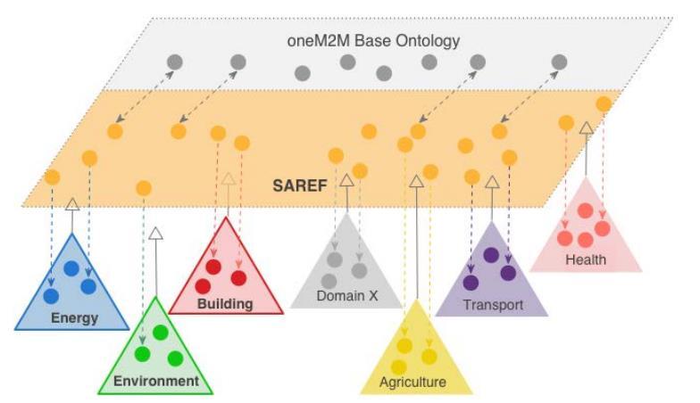
30 SAREF: OneM2M Alignment
31 SAREF4BLDG: SAREF for Buildings Links IfcBuilding to BuildingSpace

32 SAREF4BLDG: IFC Relations
33 SAREF Conclusions SAREF provides detailed descriptions of Building Devices Supports a wide range of additional modelling which can be utilised for monitoring and control. Takes a modular approach, allowing different areas of concern to be included or ignored SAREF has also been extended with IFC concepts
34 SAREF Conclusions Currently, the danger for SAREF is that it may overreach its original scope. Linking between ontologies can potentially reduce the size of the ontology Links to other ontologies, IFC, SSN, etc.
35
36 Network Management of Sensors Brief introduction to the drive for standardisation of sensor models and its relevance to Network Management Introduction to a current standard for sensors Semantic Sensor Network Ontology (SSN) Links between the SSN and another BIM standard (IFC). 36
37 Integrating BIM and Sensor Data Existing BIM standards (e.g. IFC) do not provide good support for modelling sensors or sensor readings. Sensor models are central to many Smart Building applications (see SAREF), which make use of the contextual data they provide. These sensors need to be integrated into Network Management to support their monitoring and control A method is needed to make use of BIM alongside available sensor models. 37
38 W3C Semantic Sensor Network Goal of Ontology: To define the capabilities of sensors and sensor networks. But - Sensor Data are not just about the measurements Event-based nature of sensors and sensor networks Temporal and spatial relationships Physical constraints (e.g. limited power availability, limited memory, variable data quality, loose connectivity) 38
 Observations and Measurement (O&M) OWL-2 DL ontology for describing sensors and the observations")
39 W3C Semantic Sensor Network SSN reflects existing Open Geospatial Consortium standards Sensor Model Language (SensorML) Observations and Measurement (O&M) OWL-2 DL ontology for describing sensors and the observations 39

40 Overview: Sensor configuration and management
41 SSN: Diagram Legend
42 Ontology Modularisation Ontology modularization is a common method used in ontology engineering to segment an ontology into smaller parts aims at providing users of ontologies with the knowledge they require, reducing the scope as much as possible to what is strictly necessary in a given use case. SSN make extensive use of modules, each of which can be though of as its own ontology (similar to an IFC MVD)
43 SSN Modules * * Stimulus Sensor Observation
44 Overview of SSN Ontologies
45 Sensor and environmental properties
46 DOCLE UltraLite Ontology Descriptive Ontology for Linguistic and Cognitive Engineering* (DOLCE) *
47 Main Conclusions on SSN The SSN ontology: Is compatible with the Open Geospatial Consortium (OGC) standards Is aligned with an upper ontology Dolce Ultra Light (DUL) Only includes core concepts; needs to be extended Time, location, units of measurement, domain specific (feature/property/sensor) hierarchies, etc. Does not need to be wholly reused Only observations Only sensors Unfortunately, SSN has suffered due to the complexity of the layering underneath with the DOLCE UltraLite upper level ontology!
48 Sensor, Observation, Sample and Actuator (SOSA) The Sensor, Observation, Sample and Actuator (SOSA) ontology is now one of the modules provided by the SSN. It acts as the core building block of SSN around which all other classes and relationships evolve. Support standalone usage of the ontology for applications that merely require light-weight specifications such as many Linked Datasets, the Internet Of Things, citizen science, Schema.org-style semantic enrichment of data repositories etc.
49 SOSA: Integrating Dolce-UltraLite, SSN and O&M Vertical segmentation: Vertical modules build upon each other. Without importing, may lead to different answers when reasoning over a module Lower level modules are independent of higher, and logical consistent SOSA is independent of the other ontologies
50 SOSA: Main Classes Classes: Actuation Actuator FeatureOfInterest ObservableProperty Observation Platform Procedure Result Sample Sensor
51 Aligning SSN/SOSA with IFC

52 Aligning SOSA with IFC

53 Aligning SSN/SOSA with IFC
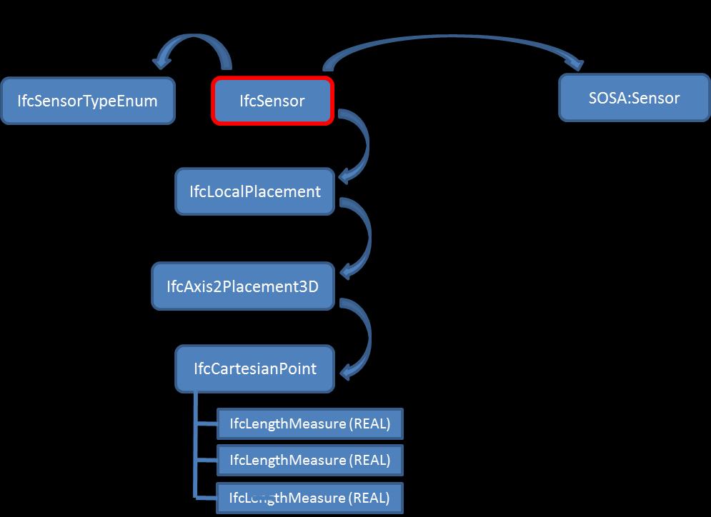
54 SOSA: Conclusions SOSA provides detailed descriptions of sensors, beyond IFC and SAREF Supports additional modelling which can be utilised for monitoring and control, e.g. related to measurement capabilities SOSA can be aligned with IFC through the IfcSensor and SOSA:Sensor concept concepts
55 55 Related Ontologies and Linking
56 Network Management of Sensors Brief introduction to the drive for standardisation of district/city models and its relevance to Network Management Introduction to a current standard for district/city modelling CityGML 56 Links between the CityGML and another BIM standard (IFC).
57 Network Management Across Districts and Cities Network managers may have networks of interest distributed across different geological scales: campuses, cities, countries, even globally. How to move between different scales to configure systems, identify and locate faults, security breaches, improve performance, etc.? District/City models provide a means to present information at larger scales, supporting different types of network management applications 57

58 DAREED: Demo
59 Integrating BIM and GIS (Geolocation) Data Existing standards for supporting BIM do not currently provide good support for geolocation. Need to identify and define requirements where convergence between geospatial and building information across the building lifecycle. 59 Spatial awareness across AEC lifecycle is defined to be a critical requirement Inside and outside of a building

60 BuildingSMART: Integrating BIM and GIS Data
61 BIM-GIS Focus How can Network Management applications and information seamlessly interact with BIM and geospatial information across the lifecycle process? How can BIM and geospatial applications be used to communicate building and district/city information requirements for Network Management operations?
62 BIM-GIS Interaction Issues What open standard tool sets (IFC-BIM, GIS, OWL/RDF, etc.) should be used to perform what functions? Are there requirements for convergence that can only be supplied by file exchange? What message format(s) should be used for data exchange? What data standards and protocols exist or need to be developed?


63 Elements in BIM are Created at a High Level of Detail This data is required to convey the information needed to construct the facility, but is not essential for other services, such as those relevant to network management and related to location.

64 Can We Use BIM As a Spatial Data Repository? File-based Proprietary data formats Exports to IFC not uniform Not easily query-able across multiple buildings Not scalable to large number of users BIM Server technology limited to design stage of buildings Not a Viable Solution Look at standards-based geospatial tools
65 Traditional Scalability Using GIS World Country Region State / Province County City Site Natural Asset Real Property Asset Air / Space Underground Water / Sea Land / Parcel Traditional GIS Space Facility / Built Building Traditional CAD/BIM Space System Space Overlay Structure Sub-Systems Level Components Room System Space Overlay Sub-Systems Level Components Room


66 Traditional Scalability Using GIS World Country Region State / Province County City Site Natural Asset Real Property Asset Air / Space Underground Water / Sea Land / Parcel Traditional GIS Space Facility / Built Building Traditional CAD/BIM Space System Space Overlay Structure Sub-Systems Level Components Room System Space Overlay Sub-Systems Level Components Room

 Device maintenance data Some of the missing")
67 BIM to GIS Integration Issues BIM is MUCH richer in detail than a GIS database GIS has only recently become fully 3-D Design BIM contains all the information needed to construct a building, but not to manage it Space polygons Asset details (make, model, etc.) Device maintenance data Some of the missing data can be supplied by other related standards, e.g. COBie GIS database and BIM will require network capabilities to share information
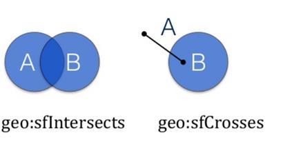
68 Fundamental Differences Between Traditional BIM and GIS BIM (IFC) Highly standardized structure Parametric highly structured File based File based exchange Inferior data exchange between commercial products Not yet widely used outside AEC Thick client GIS User defined structures Parametric loosely structured Server based - relational database File and web services for exchange Large numbers of users Thick and thin clients
69 CityGML for Integrating BIM and GIS CityGML is an application independent Geospatial Information Model for virtual 3D city and landscape models Comprises different thematic areas (buildings, vegetation, water, terrain, traffic etc.) Data model (UML) according to ISO standards family Exchange format results from mapping of the UML diagrams to a Geography Markup Language (GML3) application schema Adopted OGC standard since 08/2008


70 CityGML LOD 0 Regional, landscape model 2.5D Digital terrain model, 3D landmarks LOD 1 City / Site model Prismatic buildings without roof structures LOD 2 City / Site model Simple buildings with detailed roof structures LOD 3 City / Site model Detailed architectural models, landmarks The same object may be represented in different LODs simultaneously CityGML represents LOD 4 Interior Model Walkable architectural models 3D geometry, 3D topology, semantics, and appearance In 5 discrete scales (Levels of Detail, LOD)

71 CityGML Modules CityGML 2.0

72 CityGML Core: Geometry

73 CityGML Building Different LODs for buildings are still only small subsets of what IFC supports. Very basic information, has more in common with VR models, e.g. VRML, X3D, COLLADA and geovisualization standards like KML
74 CityGML Limitations CityGML is focused on visualization and building representation Useful for selecting buildings as part of wider district/city views thus supporting network management applications at larger scales Active research is taking place to understand how IFC and CityGML can work together.

75 Linking CityGML to IFC CityGML OWL -
76
77 GeoSPARQL GeoSPARQL is an OGC standard, which provides a minimal RDF/OWL/SPARQL vocabulary for storage and query of geospatial information Should be able to be easily attached to ontologies with a need for spatial information Represents *only* geometries and the concept of a Feature (a thing with Geometry) and the geospatial relationships between them Result: Triple store implementation can spatially index the information in the vocabulary and perform spatial reasoning GeoSPARQL intends to be: Robust enough to be used for serious geospatial data Simple enough for Linked Open Data
78 GeoSPARQL Three main components for encoding geographic information: 1. The definition of vocabularies for representing features, geometries and their relationships 2. A set of domain-specific, spatial functions for use in SPARQL queries 3. A set of query transformation rules

79 GeoSPARQL Vocabulary: Basic Classes and Relations

80 Topological Relations between geo:spatialobject i
81 GeoSPARQL Componenets Vocabulary for Query Patterns Classes Spatial Object, Feature, Geometry Properties Topological relations Links between features and geometries Datatypes for geometry literals Geo:wktLiteral, geo:gmlliteral Query Functions Topological relations, distance, buffer, intersection

82 Some GeoSPARQL Examples
83 Linking GeoSPARQL with IFC? geos:hasgeometry geo:spatial Object geo:feature geo:geometry Point Surface Polygon wkt IfcBuilding? See slides on IFC for more information on possible linking!
84
85 Future Directions: Building Topology Ontology The IFC schema is complex for new developers Currently there are moves to create a W3C Standard for Building Data on the Web Should it be based on ifcowl? GeoSPARQL? Building Topology Ontology?
86 Building Topology Ontology Focus only on the topology of buildings Developed by Pieter Pauwels and Mads Holten Being further explored within the auspices of the W3C Linked Building Data on the Web Group Community group The topology ontology is intended as a references ontology to support linking with other ontologies Provides basic concepts to model a building For web developers
87 BOT Ontology: Overview Bot:hasStorey Bot:hasSpace Bot:adjacentElement Bot:hasElement bot:building bot:storey bot:space bot:element
88 Linking BOT to GeoSPARQL Bot:hasStorey Bot:hasSpace Bot:adjacentElement Bot:hasElement bot:building bot:storey bot:space bot:element geos:hasgeometry geo:feature geo:geometry Point Surface Polygon geo:spatialobj ect wkt/gml Level of detail of wkt to support more complex building geometries?

89 Linked Building Data on the Web Get involved!
90

 Surface")
")

91 The Analytic Power of GIS Spatial analysis and modeling Overlay analysis (union, intersect) Proximity analysis (buffer, near) Surface analysis (hill shade, slope) Linear analysis (connectivity, tracing) Raster analysis Geoprocessing tools Relational Database structure Enterprise-ready Web services
GIS-based Smart Campus System using 3D Modeling
 GIS-based Smart Campus System using 3D Modeling Smita Sengupta GISE Advance Research Lab. IIT Bombay, Powai Mumbai 400 076, India smitas@cse.iitb.ac.in Concept of Smart Campus System Overview of IITB Campus
IDBE. Common conceptual framework and roadmap of collaboration in Spatial Standards for the Digital Built Environment
 IDBE Common conceptual framework and roadmap of collaboration in Spatial Standards for the Digital Built Environment GeoBIM: 3D GIS in China Mei Xue: In my opinion, what matters most in the integration
Roadmap to interoperability of geoinformation
 Roadmap to interoperability of geoinformation and services in Europe Paul Smits, Alessandro Annoni European Commission Joint Research Centre Institute for Environment and Sustainability paul.smits@jrc.it
Overview of CityGML. Dave Capstick, Ordnance Survey Research Department
 Overview of CityGML Dave Capstick, Ordnance Survey Research Department Introduction Why is citygml necessary CityGML development who is responsible? Ordnance Surveys interest 3D modelling basic concepts
3D Urban Information Models in making a smart city the i-scope project case study
 UDC: 007:528.9]:004; 007:912]:004; 004.92 DOI: 10.14438/gn.2014.17 Typology: 1.04 Professional Article 3D Urban Information Models in making a smart city the i-scope project case study Dragutin PROTIĆ
Semantic 3D City Models for Strategic Energy Planning in Berlin & London
 Semantic 3D City Models for Strategic Energy Planning in Berlin & London The content of this presentation is provided by Zhihang Yao, Robert Kaden, and Thomas H. Kolbe Chair of Geoinformatics, TU München
Geospatial Semantics for Topographic Data
 Geospatial Semantics for Topographic Data E. Lynn Usery U.S. Geological Survey Abstract. Whereas The National Map of the U.S. Geological Survey is based on data models and processes of geographic information
Spatial Data on the Web Working Group. Geospatial RDA P9 Barcelona, 5 April 2017
 Spatial Data on the Web Working Group Geospatial IG @ RDA P9 Barcelona, 5 April 2017 Spatial Data on the Web Joint effort of the World Wide Web Consortium (W3C) and the Open Geospatial Consortium (OGC)
Bentley Map Advancing GIS for the World s Infrastructure
 Bentley Map Advancing GIS for the World s Infrastructure Presentation Overview Why would you need Bentley Map? What is Bentley Map? Where is Bentley Map Used? Why would you need Bentley Map? Because your
Pushing the Standards Edge: Collaborative Testbeds to Accelerate Standards Development and Implementation
 Pushing the Standards Edge: Collaborative Testbeds to Accelerate Standards Development and Implementation Mark E. Reichardt President mreichardt@opengeospatial.org 31 October 2006 2006 Open Geospatial
GIS-based Smart Campus System using 3D Modeling
 GIS-based Smart Campus System using 3D Modeling Hardik Panchal & Rizwan Khan, Smita Sengupta, GISE Advance Lab, Indian Institute of Technology, Bombay, India N.L. Sarda, Dept. Of Computer Science, Indian
Investigating the practical relationship between GIS and BIM; then relating that to a 3D cadastre. J. Gabriel van Wyk, Johan Nel
 Investigating the practical relationship between GIS and BIM; then relating that to a 3D cadastre. J. Gabriel van Wyk, Johan Nel Overview So exactly what is BIM? Available BIM offerings in the market Traditional
CityGML XFM Application Template Documentation. Bentley Map V8i (SELECTseries 2)
") CityGML XFM Application Template Documentation Bentley Map V8i (SELECTseries 2) Table of Contents Introduction to CityGML 1 CityGML XFM Application Template 2 Requirements 2 Finding Documentation 2 To
CityGML XFM Application Template Documentation Bentley Map V8i (SELECTseries 2) Table of Contents Introduction to CityGML 1 CityGML XFM Application Template 2 Requirements 2 Finding Documentation 2 To
Virtual Cities of the Future and Past. Paul Cote Geographic Information Systems Specialist Harvard University Graduate School of Design
 Virtual Cities of the Future and Past Paul Cote Geographic Information Systems Specialist Harvard University Graduate School of Design 500 Design Students 250 Architecture 50 Urban Planning 100 Urban Design
Geo-Enabling Digital India. 15 th Esri India User Conference GIS and Smart Cities
 15 th Esri India User Conference 2014 GIS and Smart Cities 15 th Esri India User Conference 2014 GIS and Smart Cities Agendra Kumar President, Esri India Our World Is Facing Serious Challenges Our World
Features and Benefits
 Autodesk LandXplorer Features and Benefits Use the Autodesk LandXplorer software family to help improve decision making, lower costs, view and share changes, and avoid the expense of creating physical
Application Domain Extensions definition for crowd source and Volunteer Geographic Information for smart-cities services deployment.
 Application Domain Extensions definition for crowd source and Volunteer Geographic Information for smart-cities services deployment. F. Prandi, R. de Amicis, P. Parslow, M. Ford, E. D Hondt Outlook Introduction
The (Rough) road to BIM- Geospatial standards. Leif Granholm BIM ambassador
 road to BIM- Geospatial standards. Leif Granholm BIM ambassador") The (Rough) road to BIM- Geospatial standards Leif Granholm BIM ambassador What is Structured Semantic data BIM Graphics to objects Drawings geometry are graphics (appearance important) A Model consists
The (Rough) road to BIM- Geospatial standards Leif Granholm BIM ambassador What is Structured Semantic data BIM Graphics to objects Drawings geometry are graphics (appearance important) A Model consists
Web Visualization of Geo-Spatial Data using SVG and VRML/X3D
 Web Visualization of Geo-Spatial Data using SVG and VRML/X3D Jianghui Ying Falls Church, VA 22043, USA jying@vt.edu Denis Gračanin Blacksburg, VA 24061, USA gracanin@vt.edu Chang-Tien Lu Falls Church,
BIM Week October 2013 Munich, GERMANY
 BIM Week October 2013 Munich, GERMANY Paul Scarponcini, PE, PhD Bentley Systems, Inc. COBie (for Buildings) Based on MVD of Building IFCs no geometry extended constraints, attributes, relationships Uses
Developing 3D Geoportal for Wilayah Persekutuan Iskandar
 Developing 3D Geoportal for Wilayah Persekutuan Iskandar Dionnald Beh BoonHeng and Alias Abdul Rahman Department of Geoinformatics, Faculty of Geoinformation Engineering and Sciences, Universiti Teknologi
INSPIREd solutions for Air Quality problems Alexander Kotsev
 INSPIREd solutions for Air Quality problems Alexander Kotsev www.jrc.ec.europa.eu Serving society Stimulating innovation Supporting legislation The European data puzzle The European data puzzle 24 official
Using OGC standards to improve the common
 Using OGC standards to improve the common operational picture Abstract A "Common Operational Picture", or a, is a single identical display of relevant operational information shared by many users. The
7 11 August 2011, Vancouver. Don Brutzman, Benjamin Hagedorn. The OGC: Making Location Count
 OGC 3D Portrayal Interoperability Experiment, OGC 3D Summit 2011 SIGGRAPH 2011 7 11 August 2011, Vancouver Don Brutzman, Benjamin Hagedorn The OGC: Making Location Count What is the Open Geospatial Consortium?
Bentley Map V8i (SELECTseries 3)
") Bentley Map V8i (SELECTseries 3) A quick overview Why Bentley Map Viewing and editing of geospatial data from file based GIS formats, spatial databases and raster Assembling geospatial/non-geospatial data
Bentley Map V8i (SELECTseries 3) A quick overview Why Bentley Map Viewing and editing of geospatial data from file based GIS formats, spatial databases and raster Assembling geospatial/non-geospatial data
Questions and Answers
 AUTODESK LANDXPLORER SOFTWARE FAMILY Questions and Answers The Autodesk LandXplorer 3D city model software family can help you create, analyze, and visualize digital city models. Contents Autodesk Landxplorer
CARTOGRAPHIC WEB SERVICES AND CARTOGRAPHIC RULES A NEW APPROACH FOR WEB CARTOGRAPHY
 CARTOGRAPHIC WEB SERVICES AND CARTOGRAPHIC RULES A NEW APPROACH FOR WEB CARTOGRAPHY 1. Introduction Ionut Iosifescu, Marco Hugentobler, Lorenz Hurni ETH Zurich, Institute of Cartography Wolfgang-Pauli-Str.
Canadian Board of Examiners for Professional Surveyors Core Syllabus Item C 5: GEOSPATIAL INFORMATION SYSTEMS
 Study Guide: Canadian Board of Examiners for Professional Surveyors Core Syllabus Item C 5: GEOSPATIAL INFORMATION SYSTEMS This guide presents some study questions with specific referral to the essential
Spatial Data Infrastructure Concepts and Components. Douglas Nebert U.S. Federal Geographic Data Committee Secretariat
 Spatial Data Infrastructure Concepts and Components Douglas Nebert U.S. Federal Geographic Data Committee Secretariat August 2009 What is a Spatial Data Infrastructure (SDI)? The SDI provides a basis for
Paper UC1351. Conference: User Conference Date: 08/10/2006 Time: 8:30am-9:45am Room: Room 23-B (SDCC)
") Conference: User Conference Date: 08/10/2006 Time: 8:30am-9:45am Room: Room 23-B (SDCC) Title of Paper: Increasing the Use of GIS in the Federal Government Author Name: Miss Abstract This presentation
Conference: User Conference Date: 08/10/2006 Time: 8:30am-9:45am Room: Room 23-B (SDCC) Title of Paper: Increasing the Use of GIS in the Federal Government Author Name: Miss Abstract This presentation
CityGML in Detail Part 2
 CityGML in Detail Part 2 Prof. Dr. Thomas H. Kolbe Institute for Geodesy and Geoinformation Science Berlin University of Technology kolbe@igg.tu-berlin.de May 2008 EduServ6 Course on CityGML Copyright
NR402 GIS Applications in Natural Resources
 NR402 GIS Applications in Natural Resources Lesson 1 Introduction to GIS Eva Strand, University of Idaho Map of the Pacific Northwest from http://www.or.blm.gov/gis/ Welcome to NR402 GIS Applications in
Model Setup IDM Vol 2: Process Model
 Model Setup IDM Vol 2: Process Model Gateway to Melbourne, Australia. Source: Fender Katsalidis, Architects Version 1.4 27 June 2017 Contents Model Setup Exchange Scenarios... 1 Overview... 1 Project Roles...
Mark E Reichardt. President & CEO Open Geospatial Consortium
 Mark E Reichardt President & CEO Open Geospatial Consortium mreichardt@myogc.org Agenda 0900-0915 Welcome and Introduction - Topic setting (Chair) 0915-0935 Ron Bloksma, The next step is interoperability
<Insert Picture Here> Oracle Spatial 11g. Dr. Siva Ravada
 Oracle Spatial 11g Dr. Siva Ravada New in Oracle Spatial 11g 3D Support Spatial Web Services Network Data Model GeoRaster Performance Improvements 3D Applications Location-based services
Your Perfect 3D World (BIM and GIS Integrated)
") Your Perfect 3D World (BIM and GIS Integrated) June 2015 Larisa Kruger Background Larisa Kruger- Enterprise GIS Manager FITS- Facilities Information Technology Services 2 years (GIS for 15) 2 FTE, 4 students
Your Perfect 3D World (BIM and GIS Integrated) June 2015 Larisa Kruger Background Larisa Kruger- Enterprise GIS Manager FITS- Facilities Information Technology Services 2 years (GIS for 15) 2 FTE, 4 students
Overview of Geospatial Open Source Software which is Robust, Feature Rich and Standards Compliant
 Overview of Geospatial Open Source Software which is Robust, Feature Rich and Standards Compliant Cameron SHORTER, Australia Key words: Open Source Geospatial Foundation, OSGeo, Open Standards, Open Geospatial
On the convergence of 3D-GIS, CAD and 3D Simulation
 On the convergence of 3D-GIS, CAD and 3D Simulation V. Coors, Stuttgart University of Applied Science, Volker.Coors@hft-stuttgart.de Urban information space Due to improved tools for the design and acquisition
Esri UC2013. Technical Workshop.
 Esri International User Conference San Diego, California Technical Workshops July 9, 2013 CAD: Introduction to using CAD Data in ArcGIS Jeff Reinhart & Phil Sanchez Agenda Overview of ArcGIS CAD Support
Semantic Evolution of Geospatial Web Services: Use Cases and Experiments in the Geospatial Semantic Web
 Semantic Evolution of Geospatial Web Services: Use Cases and Experiments in the Geospatial Semantic Web Joshua Lieberman, Todd Pehle, Mike Dean Traverse Technologies, Inc., Northrop Grumman Information
OGC 3D Portrayal Interoperability Experiment (3DPIE) Insights and Results
 Insights and Results") OGC 3D Portrayal Interoperability Experiment (3DPIE) Insights and Results Jan Klimke, Benjamin Hagedorn (Hasso-Plattner-Institut at the University Potsdam) Web 3D 2012 Los Angeles, August 4, 2012 Agenda
OGC 3D Portrayal Interoperability Experiment (3DPIE) Insights and Results Jan Klimke, Benjamin Hagedorn (Hasso-Plattner-Institut at the University Potsdam) Web 3D 2012 Los Angeles, August 4, 2012 Agenda
Ontological requirement specification for smart irrigation system: a SSN and SAREF comparison
 1 Ontological requirement specification for smart irrigation system: a SSN and SAREF comparison María POVEDA-VILLALÓN Quang-Duy NGUYEN Catherine ROUSSEY Jean-Pierre CHANET Christophe de VAULX Workshop
INSPIRing Geospatial Framework For Local Administrations
 This project is financed by the European Union and the Republic of Turkey Presented at the FIG Congress 2018, May 6-11, 2018 in Istanbul, Turkey National Programme for Turkey 2010 Instrument for Pre-Accession
DGIWG 200. Defence Geospatial Information Framework (DGIF) Overview
 Overview") DGIWG 200 Defence Geospatial Information Framework (DGIF) Overview Document type: Standard Document date: 28 November 2017 Edition: 2.0.0 Responsible Party: Audience: Abstract: Copyright: Defence Geospatial
DGIWG 200 Defence Geospatial Information Framework (DGIF) Overview Document type: Standard Document date: 28 November 2017 Edition: 2.0.0 Responsible Party: Audience: Abstract: Copyright: Defence Geospatial
Discovery and Access of Geospatial Resources using the Geoportal Extension. Marten Hogeweg Geoportal Extension Product Manager
 Discovery and Access of Geospatial Resources using the Geoportal Extension Marten Hogeweg Geoportal Extension Product Manager DISCOVERY AND ACCESS USING THE GEOPORTAL EXTENSION Geospatial Data Is Very
Visualizing Big Data on Maps: Emerging Tools and Techniques. Ilir Bejleri, Sanjay Ranka
 Visualizing Big Data on Maps: Emerging Tools and Techniques Ilir Bejleri, Sanjay Ranka Topics Web GIS Visualization Big Data GIS Performance Maps in Data Visualization Platforms Next: Web GIS Visualization
DECISION SUPPORT SYSTEMS FOR PARTICIPATORY FLOOD RISK AND DISASTER MANAGEMENT
 DECISION SUPPORT SYSTEMS FOR PARTICIPATORY FLOOD RISK AND DISASTER MANAGEMENT PhD Thesis Panayiotis Sophronides, Dipl.-Ing., MSc & DIC, PhD Candidate Advisory committee: Prof. Maria Giaoutzi (Supervisor),
You are Building Your Organization s Geographic Knowledge
 You are Building Your Organization s Geographic Knowledge And Increasingly Making it Available Sharing Data Publishing Maps and Geo-Apps Developing Collaborative Approaches Citizens Knowledge Workers Analysts
Innovation. The Push and Pull at ESRI. September Kevin Daugherty Cadastral/Land Records Industry Solutions Manager
 Innovation The Push and Pull at ESRI September 2004 Kevin Daugherty Cadastral/Land Records Industry Solutions Manager The Push and The Pull The Push is the information technology that drives research and
The importance of persistent URIs for the implementation of INSPIRE
 The importance of persistent URIs for the implementation of INSPIRE INSPIRE Conference 2012, Istanbul Clemens Portele, interactive instruments GmbH Drafting Team Data Specifications (Chair) Directive,
ESRI Survey Summit August Clint Brown Director of ESRI Software Products
 ESRI Survey Summit August 2006 Clint Brown Director of ESRI Software Products Cadastral Fabric How does Cadastral fit with Survey? Surveyors process raw field observations Survey measurements define high-order
BIM and INSPIRE, for a better integration of built infrastructures in their environment : the MINnD project
 BIM and INSPIRE, for a better integration of built infrastructures in their environment : the MINnD project François ROBIDA Christophe CASTAING Strasbourg, > 1 8 septembre 2017 ABOUT BIM Building Information
Part 1: Fundamentals
 Provläsningsexemplar / Preview INTERNATIONAL STANDARD ISO 19101-1 First edition 2014-11-15 Geographic information Reference model Part 1: Fundamentals Information géographique Modèle de référence Partie
OGC Standards Update 29 November 2018 Orlando
 OGC Standards Update 29 November 2018 Orlando Mark Reichardt mreichardt@opengeospatial.org +1 301 840-1361 OGC S INTEREST It s simple You have this or this and you need to make this... or this Courtesy
Smart Cities: Visualization
 Smart Cities: Visualization ISO/IEC JTC 1/SC24 Meetings 20-25 January 2019 Seoul, Korea Peter Ryan 1 and Myeong Won Lee 2 1 Defence Science & Technology Group, Australia 2 University of Suwon, Korea Presentation
SMART CITIES NEED LOCATION DATA
 SMART CITIES NEED LOCATION DATA Carsten Rönsdorf 27 May 2015 Lisbon Future Cities need Location Data Geospatial World Forum 27 May 2015 Carsten Rönsdorf, Head of Advisory Services, OS International OFFICIAL
Chapter 10: BIM for Facilitation of Land Administration Systems in Australia
 Chapter 10: BIM for Facilitation of Land Administration Systems in Australia Sam Amirebrahimi Introduction With the introduction of the concept of 3D Cadastre and extensive efforts in this area, currently
June 19 Huntsville, Alabama 1
 June 19 Huntsville, Alabama 1 Real-Time Geospatial Data: The Fusion of PI and ArcGIS Enabling Smarter Facilities Management OSIsoft and Esri Mapping and Location Analytics Platform Supporting Your Use
Geog 469 GIS Workshop. Managing Enterprise GIS Geodatabases
 Geog 469 GIS Workshop Managing Enterprise GIS Geodatabases Outline 1. Why is a geodatabase important for GIS? 2. What is the architecture of a geodatabase? 3. How can we compare and contrast three types
Implementing INSPIRE Geoportal in Turkey
 Implementing INSPIRE Geoportal in Turkey Gencay SERTER City and Regional Planner 1 Presentation Plan Introduction INSPIRE and Turkey Importance of al Spatial Planning Portal Logical&Legal Hierarchy GeoPortal
NAG-City Expert Workshop Oslo 8-9. October 2012 SOSI standards and mapping for Europe (INSPIRE)
") NAG-City Expert Workshop Oslo 8-9. October 2012 SOSI standards and mapping for Europe (INSPIRE) Per Ryghaug, Geomatics The Norwegian national standard on geographic information - SOSI Started in 1984 NGU
NAG-City Expert Workshop Oslo 8-9. October 2012 SOSI standards and mapping for Europe (INSPIRE) Per Ryghaug, Geomatics The Norwegian national standard on geographic information - SOSI Started in 1984 NGU
From the Venice Lagoon Atlas towards a collaborative federated system
 From the Venice Lagoon Atlas towards a collaborative federated system City of Venice Alessandro Mulazzani CORILA Consortium for Coordination of Research Activities Concerning the Venice Lagoon System ISMAR-CNR
Web 3D Service & CityGML Update
 Technische Universität Berlin Web 3D Service & CityGML Update Thomas H. Kolbe Institute for Geodesy and Geoinformation Science Berlin University of Technology kolbe@igg.tu-berlin.de 2nd of November, 2007
Imagery and the Location-enabled Platform in State and Local Government
 Imagery and the Location-enabled Platform in State and Local Government Fred Limp, Director, CAST Jim Farley, Vice President, Leica Geosystems Oracle Spatial Users Group Denver, March 10, 2005 TM TM Discussion
INTEGRATING GIS AND BIM FOR COMMUNITY BUILDING ENERGY DESIGN. Yunpiao Bai. B.E.s., The University of Waterloo, 2014
 INTEGRATING GIS AND BIM FOR COMMUNITY BUILDING ENERGY DESIGN by Yunpiao Bai B.E.s., The University of Waterloo, 2014 A THESIS SUBMITTED IN PARTIAL FULFILLMENT OF THE REQUIREMENTS FOR THE DEGREE OF MASTER
ISO Series Standards in a Model Driven Architecture for Landmanagement. Jürgen Ebbinghaus, AED-SICAD
 ISO 19100 Series Standards in a Model Driven Architecture for Landmanagement Jürgen Ebbinghaus, AED-SICAD 29.10.2003 The Company 100% SIEMENS PTD SIEMENS Business Services Shareholder & Strategic Business
Geog 469 GIS Workshop. Data Analysis
 Geog 469 GIS Workshop Data Analysis Outline 1. What kinds of need-to-know questions can be addressed using GIS data analysis? 2. What is a typology of GIS operations? 3. What kinds of operations are useful
Making interoperability persistent: A 3D geo database based on CityGML
 Making interoperability persistent: A 3D geo database based on CityGML Alexandra Stadler, Claus Nagel, Gerhard König, Thomas H. Kolbe Technische Universität Berlin Chair of Geoinformation Science Motivation
INSPIRE General Introduction & Service Architecture
 INSPIRATION Spatial Data Infrastructure in the Western Balkans INSPIRE General Introduction & Service Architecture 1st National INSPIRATION Workshop Croatia November 21-22, 2012 A multi-countryprojectfunded
The File Geodatabase API. Craig Gillgrass Lance Shipman
 The File Geodatabase API Craig Gillgrass Lance Shipman Schedule Cell phones and pagers Please complete the session survey we take your feedback very seriously! Overview File Geodatabase API - Introduction
gvsig a real tool for GIS technicians
 gvsig a real tool for GIS technicians Jorge Gaspar Sanz Salinas jsanz@prodevelop.es International Geodetic Students Meeting 05/05/08 Valencia Agenda of the project OK, but what can gvsig do for me now?
A Geographer s role in a Google Maps World. Jeremy Bartley ESRI
 A Geographer s role in a Google Maps World Jeremy Bartley ESRI 1 It is a good time to be a Geographer. 2 Microsoft, Google, Yahoo, and others are pushing geographic awareness to the general public Providing
INSPIRE - A Legal framework for environmental and land administration data in Europe
 INSPIRE - A Legal framework for environmental and land administration data in Europe Dr. Markus Seifert Bavarian Administration for Surveying and Cadastre Head of the SDI Office Bavaria Delegate of Germany
Technical Specifications. Form of the standard
 Used by popular acceptance Voluntary Implementation Mandatory Legally enforced Technical Specifications Conventions Guidelines Form of the standard Restrictive Information System Structures Contents Values
Important note To cite this publication, please use the final published version (if applicable). Please check the document version above.
. Please check the document version above.") Delft University of Technology Building Information Modelling: essentials and issues The need to Integrate BIM and Geoinformation Zlatanova, Sisi; Isikdag, Umit Publication date 2016 Document Version Early
Delft University of Technology Building Information Modelling: essentials and issues The need to Integrate BIM and Geoinformation Zlatanova, Sisi; Isikdag, Umit Publication date 2016 Document Version Early
Free and Open Source Software for Cadastre and Land Registration : A Hidden Treasure? Gertrude Pieper Espada. Overview
 Free and Open Source Software for Cadastre and Land Registration : A Hidden Treasure? Gertrude Pieper Espada Overview FLOSS concepts Digital Land Administration systems FLOSS Database alternatives FLOSS
Geospatial Preservation: State of the Landscape. A Quick Overview. Steve Morris NCSU Libraries
 Geospatial Preservation: State of the Landscape A Quick Overview Steve Morris NCSU Libraries SAA 2011 August 26, 2011 14 Brief Overview of the Problem 15 Variety of Geospatial Data Types Variety of producers
TRAITS to put you on the map
 TRAITS to put you on the map Know what s where See the big picture Connect the dots Get it right Use where to say WOW Look around Spread the word Make it yours Finding your way Location is associated with
AEC 3 United Kingdom. Industry Foundation Classes. Norwegian IFG project Harmonisation IFC and gml3. Dr. Thomas Liebich, Jeffrey Wix AEC3 Ltd.
 Industry Foundation Classes AEC 3 United Kingdom Thatcham, Berkshire RG18 3ES Tel: +44-1635 86 4590 Fax: +44-1635 86 0673 email: jeffrey.wix@aec3.com Germany D-80636 München Tel: +49-89-1870 3223 Fax:
3D City/Landscape Modeling Non-Building Thematic: Vegetation
 3D City/Landscape Modeling Non-Building Thematic: Vegetation Presenter: Shafarina Wahyu Trisyanti shafarina.wahyu@gmail.com Co-Author: Deni Suwardhi, Agung Budi Harto dsuwardhi@kk-insig.org, agung@gd.itb.ac.id
Sova3D - Pilot Case: Hyvinkää Architectural Competition. Internet of Spaces
 Sova3D - Pilot Case: Hyvinkää Architectural Competition SOVA3D SOVA3D offers Internet Based Services for Building Environment 3D Digitalisation. - 3D-VIRTUALMODELS - City Model - Geometry Models - BIM
Data Aggregation with InfraWorks and ArcGIS for Visualization, Analysis, and Planning
 Data Aggregation with InfraWorks and ArcGIS for Visualization, Analysis, and Planning Stephen Brockwell President, Brockwell IT Consulting, Inc. Join the conversation #AU2017 KEYWORD Class Summary Silos
May 2011 Oracle Spatial User Conference
 May 2011 Oracle Spatial User Conference Oracle Spatial User Conference! May 19, 2011 Ronald Reagan Building and International Trade Center Washington, DC USA May 2011 Oracle Spatial User Conference Francois
Geospatial Products V8i (SELECTseries 1)
") Geospatial Products V8i (SELECTseries 1) Keith Raymond Product Manager Geospatial Desktop Products Presentation Overview What are the various products? Why would you need them? Demonstrations 2 WWW.BENTLEY.COM
Geospatial Products V8i (SELECTseries 1) Keith Raymond Product Manager Geospatial Desktop Products Presentation Overview What are the various products? Why would you need them? Demonstrations 2 WWW.BENTLEY.COM
CityGML 3D Geospatial and Semantic Modelling of Urban Structures
 Technische Universität Berlin CityGML 3D Geospatial and Semantic Modelling of Urban Structures Prof. Dr. Thomas H. Kolbe Institute for Geodesy and Geoinformation Science Berlin University of Technology
Introduction to GIS I
 Introduction to GIS Introduction How to answer geographical questions such as follows: What is the population of a particular city? What are the characteristics of the soils in a particular land parcel?
The Standard Infrastructure
 GISize! The Standard Infrastructure Management Interface for Wonderware Presenter Selim Birced GISize! Introduction 2 GISize! The Standard Infrastructure Management Interface A framework designed to: Helping
ArcGIS Enterprise: What s New. Philip Heede Shannon Kalisky Melanie Summers Shreyas Shinde
 ArcGIS Enterprise: What s New Philip Heede Shannon Kalisky Melanie Summers Shreyas Shinde ArcGIS Enterprise is the new name for ArcGIS for Server ArcGIS Enterprise Software Components ArcGIS Server Portal
Building a National Data Repository
 Building a National Data Repository Mladen Stojic, Vice President - Geospatial 1/30/2013 2012 Intergraph Corporation 1 Information has meaning and gives power only when shared and distributed. Information,
buildingsmart International and Open Geospatial Consortium Framework for Collaboration on BIM-GIS Interoperability
 buildingsmart International and Open Geospatial Consortium Framework for Collaboration on BIM-GIS Interoperability Jim Plume, Carsten Rönsdorf, and Scott Simmons Copyright 2017 Open Geospatial Consortium
Bentley Map Advancing GIS for the World s Infrastructure
 Bentley Map Advancing GIS for the World s Infrastructure Presentation Overview Why would you need Bentley Map? What is Bentley Map? Where is Bentley Map Used? Red text signifies new things in Bentley Map
Technical Framework Methodology as a core of building up the NSDI NSDI Implementation Specifics in Serbia
 Technical Framework Methodology as a core of building up the NSDI NSDI Implementation Specifics in Serbia Luka Jovičić SDI Consultant@ Gramont Ltd. Aleksandar Dedić RGA NSDI department Dragica Pajić RGA
Web-based Exploration of and Interaction with Large and Deeply Structured Semantic 3D City Models using HTML5 and WebGL
 Web-based Exploration of and Interaction with Large and Deeply Structured Semantic 3D City Models using HTML5 and WebGL KANISHK CHATURVEDI 1, ZHIHANG YAO 2 & THOMAS H. KOLBE 1 Abstract: The aim of the
Design and implementation of a new meteorology geographic information system
 Design and implementation of a new meteorology geographic information system WeiJiang Zheng, Bing. Luo, Zhengguang. Hu, Zhongliang. Lv National Meteorological Center, China Meteorological Administration,
Integrating Building Information Models with Open Geospatial Web Services
 Open Geospatial Consortium Interoperability Testbed 4 for CAD/GIS/BIM Integrating Building Information Models with Open Geospatial Web Services Prepared by: Paul Cote Harvard Graduate School of Design
What is GIS and How Can It Help Me?
 esri European User Conference Madrid 2011 What is GIS and How Can It Help Me? Jaime Nieves Ignacio Vázquez esri spain «Knowing where things are, and why, is essential to rational decision making.» Jack
EXPLORING SUBSET PROFILE AND VALIDATION PROCEDURES OF GEOGRAPHICAL MARKUP LANGUAGE (GML) FOR 3D AREAL PLAN INFORMATION.
 FOR 3D AREAL PLAN INFORMATION.") www.sgem.org Geoinformatics EXPLORING SUBSET PROFILE AND VALIDATION PROCEDURES OF GEOGRAPHICAL MARKUP LANGUAGE (GML) FOR 3D AREAL PLAN INFORMATION. Assoc. Prof Dr Erling Onstein 1 Assist. Prof Sverre Stikbakke
www.sgem.org Geoinformatics EXPLORING SUBSET PROFILE AND VALIDATION PROCEDURES OF GEOGRAPHICAL MARKUP LANGUAGE (GML) FOR 3D AREAL PLAN INFORMATION. Assoc. Prof Dr Erling Onstein 1 Assist. Prof Sverre Stikbakke
An Ontology-based Framework for Modeling Movement on a Smart Campus
 An Ontology-based Framework for Modeling Movement on a Smart Campus Junchuan Fan 1, Kathleen Stewart 1 1 Department of Geographical and Sustainability Sciences, University of Iowa, Iowa City, IA, 52242,
SPATIAL INFORMATION GRID AND ITS APPLICATION IN GEOLOGICAL SURVEY
 SPATIAL INFORMATION GRID AND ITS APPLICATION IN GEOLOGICAL SURVEY K. T. He a, b, Y. Tang a, W. X. Yu a a School of Electronic Science and Engineering, National University of Defense Technology, Changsha,
Spatial Statistical Information Services in KOSTAT
 Distr. GENERAL WP.30 12 April 2010 ENGLISH ONLY UNITED NATIONS ECONOMIC COMMISSION FOR EUROPE (UNECE) CONFERENCE OF EUROPEAN STATISTICIANS EUROPEAN COMMISSION STATISTICAL OFFICE OF THE EUROPEAN UNION (EUROSTAT)