The impacts of Open Government initiatives on SDIs
|
|
|
- Ariel Phelps
- 6 years ago
- Views:
Transcription
1 The impacts of Open Government initiatives on SDIs Martin Seiler Coordination Office SDI Germany INSPIRE Conference 2013 Florence, 27 June 2013
2 Outline (Open) Government in Germany GDI-DE-architecture govdata.de architecture Providing geospatial metadata to govdata.de Conclusion & Outlook
3 Administrative structure federation 16 federal states ( Bundesländer ) GeoBasis-DE / BKG 2013


4 Administrative structure federation 16 federal states ( Bundesländer ) ~ municipalities GeoBasis-DE / BKG 2013
5 Administrative structure federation 16 federal states ( Bundesländer ) ~ municipalities They all own data! GeoBasis-DE / BKG 2013
6 Open Government Common Drivers: public discourse about transparency in politics revision of PSI directive governmental data as public good economic potential through innovation
7 Open Government But diverse: laws cultures mindsets implementations GeoBasis-DE / BKG 2013
8 What is open data? Open Knowledge Foundation: defines 11 criteria: / (e.g. access/technological restriction, reuse/attribution, integrity, details about licenses, statements regarding discrimination, )
9 What is open data? Open Knowledge Foundation: defines 11 criteria: / (e.g. access/technological restriction, reuse/attribution, integrity, details about licenses, statements regarding discrimination, ) govdata.de is less demanding clear license statement license considered open data available for download data available in a machine readable format


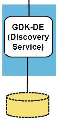
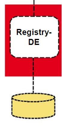
10 SDI architecture
11 SDI architecture
12 SDI architecture
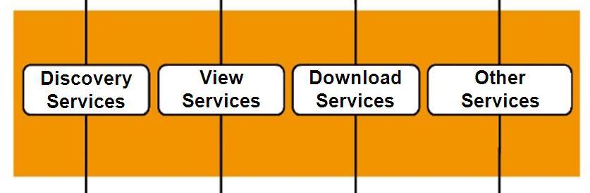
13 SDI architecture > 30 Discovery Services connected
14 Govdata.de portal on federal level nation-wide, harmonized access to open data search and access through a single website harmonized categories, metadata prototype online since 03/2013 large share of data in administrations is spatial data!
15 Govdata.de portal on federal level nation-wide, harmonized access to open data search and access through a single website harmonized categories, metadata prototype online since 03/2013 large share of data in administrations is spatial data! We have an application for your SDI!!


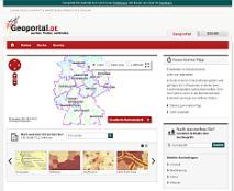
16 Govdata.de
17 Govdata.de architecture Source: Marienfeld (2012)

18 Govdata.de architecture Source: Marienfeld (2012)
19 GDI-DE vs. govdata.de GDI-DE Govdata.de Interface ISO AP CKAN-APIs Format XML JSON Data model ISO CKAN-Profil Complexity high low Standard license no yes
20 GDI-DE vs. govdata.de GDI-DE Govdata.de Interface ISO AP CKAN-APIs Format XML JSON Data model ISO CKAN-Profile Complexity high low Standard license no yes
21 Challenges identifying open data in the central
22 Challenges identifying open data in the central mapping ISO to CKAN-Profile, e.g. Point of Contacts
23 Challenges identifying open data in the central mapping ISO to CKAN-Profile, e.g. Point of Contacts
24 Challenges identifying open data in the central mapping ISO to CKAN-Profile, e.g. Point of Contacts Data Service Coupling
25 Challenges identifying open data in the central mapping ISO to CKAN-Profile, e.g. Point of Contacts Data Service Coupling Restrictions on access and use
26 Challenges identifying open data in the central mapping ISO to CKAN-Profile, e.g. Point of Contacts Data Service Coupling Restrictions on access and use additional agreements on metadata in GDI-DE
27 Challenges identifying open data in the central mapping ISO to CKAN-Profile, e.g. Point of Contacts Data Service Coupling Restrictions on access and use additional agreements on metadata in GDI-DE Keyword:
28 Challenges identifying open data in the central mapping ISO to CKAN-Profile, e.g. Point of Contacts Data Service Coupling Restrictions on access and use additional agreements on metadata in GDI-DE {name: Name of License URL: Attribution: Attribution Text }
29 Challenges identifying open data in the central mapping ISO to CKAN-Profile, e.g. Point of Contacts Data Service Coupling Restrictions on access and use additional agreements on metadata in GDI-DE resolve data-service coupling
30 Challenges identifying open data in the central mapping ISO to CKAN-Profile, e.g. Point of Contacts Data Service Coupling Restrictions on access and use additional agreements on metadata in GDI-DE resolve data-service coupling json export
31 Challenges identifying open data in the central mapping ISO to CKAN-Profile, e.g. Point of Contacts Data Service Coupling Restrictions on access and use promote common licenses keeping the infrastructures in sync identification of resources
32 Challenges GDI-DE central local
33 Challenges GDI-DE central local (local, regional, thematic)
34 Challenges GDI-DE central (central) ISO local (local, regional, thematic) Source: Weichand (2013), edited
35 Challenges GDI-DE central (central) ISO local (local, regional, thematic) (local, regional, thematic) Source: Weichand (2013), edited
36 Challenges GDI-DE central (central) ISO local (local, regional, thematic) (local, regional, thematic) Source: Weichand (2013), edited
37 Challenges GDI-DE central (central) ISO local (local, regional, thematic) ISO CKAN (local, regional, thematic) Source: Weichand (2013), edited
38 Challenges GDI-DE central (central) Govdata.de (central) ISO local (local, regional, thematic) ISO CKAN (local, regional, thematic) Source: Weichand (2013), edited
39 Challenges GDI-DE central (central) Govdata.de (central) ISO CKAN local (local, regional, thematic) ISO CKAN (local, regional, thematic) Source: Weichand (2013), edited
40 Challenges GDI-DE central (central) Govdata.de (central) ISO CKAN local (local, regional, thematic) ISO CKAN (local, regional, thematic) Source: Weichand (2013), edited
41 Challenges GDI-DE central (central) ISO CKAN Govdata.de (central) ISO CKAN local (local, regional, thematic) ISO CKAN (local, regional, thematic) Source: Weichand (2013), edited
42 Challenges GDI-DE Transformation A: central (central) ISO CKAN Govdata.de (central) Transformation A!= Transformation B ISO CKAN local (local, regional, thematic) Transformation B: ISO CKAN (local, regional, thematic) Source: Weichand (2013), edited
43 Challenges GDI-DE Transformation A: central (central) ISO CKAN Govdata.de (central) Transformation A!= Transformation B ISO CKAN - Duplicates? - Priorities? local (local, regional, thematic) Transformation B: ISO CKAN (local, regional, thematic) Source: Weichand (2013), edited
44 Challenges SDI Europe central (central) Transformation A: ISO CKAN Govdata.de (central) ISO CKAN local (local, regional, thematic) Transformation B: ISO CKAN (local, regional, thematic) Source: Weichand (2013), edited
45 Challenges SDI Europe (INSPIRE) ISO CKAN DCAT central (central) Transformation A: ISO CKAN Govdata.de (central) ISO CKAN local (local, regional, thematic) Transformation B: ISO CKAN (local, regional, thematic) Source: Weichand (2013), edited
46 Challenges SDI Transformation C: Europe (INSPIRE) ISO ISO DCAT Transformation D: CKAN DCAT central (central) Transformation A: ISO CKAN Govdata.de (central) ISO CKAN local (local, regional, thematic) Transformation B: ISO CKAN (local, regional, thematic) Source: Weichand (2013), edited
47 Conclusion lessons learned about usefulness of the infrastructure for others
48 Conclusion lessons learned about usefulness of the infrastructure for others reduce complexity
49 Conclusion lessons learned about usefulness of the infrastructure for others reduce complexity care about requirements of potential/new users
50 Conclusion lessons learned about usefulness of the infrastructure for others reduce complexity care about requirements of potential/new users open up
51 Conclusion lessons learned about usefulness of the infrastructure for others reduce complexity care about requirements of potential/new users open up high quality metadata is crucial (automatisms, editors)
52 Conclusion lessons learned about usefulness of the infrastructure for others reduce complexity care about requirements of potential/new users open up high quality metadata is crucial (automatisms, editors) INSPIRE metadata IR/TG need improvement
53 Conclusion lessons learned about usefulness of the infrastructure for others reduce complexity care about requirements of potential/new users open up high quality metadata is crucial (automatisms, editors) INSPIRE metadata IR/TG need improvement clear license statements are essential
54 Conclusion lessons learned about usefulness of the infrastructure for others reduce complexity care about requirements of potential/new users open up high quality metadata is crucial (automatisms, editors) INSPIRE metadata IR/TG need improvement clear license statements are essential centralized architecture is adjusting slowly
55 Conclusion lessons learned about usefulness of the infrastructure for others reduce complexity care about requirements of potential/new users open up high quality metadata is crucial (automatisms, editors) INSPIRE metadata IR/TG need improvement clear license statements are essential centralized architecture is adjusting slowly is a challenge and a chance
56 Thank you Questions?
Connecting SDI to an Open Data Portal The German Technical Adapter
 Connecting SDI to an Open Data Portal The German Technical Adapter INSPIRE-Geospatial World Forum, 28 May 2015, Lisbon Jürgen Walther Federal Agency for Cartography and Geodesy Outline Why participating
Implementing the Smart Growth Priority in an Open and Interoperable System for Geographic Data: Sardinia SITR- IDT
 REGION OF SARDINIA (ITALY) LOCAL AUTHORITY FOR MUNICIPALITIES, FINANCES AND URBAN PLANNING DEPT. FOR THE REGIONAL SPATIAL DATA INFRASTRUCTURE Implementing the Smart Growth Priority in an Open and Interoperable
EXPECTATIONS OF TURKISH ENVIRONMENTAL SECTOR FROM INSPIRE
 EXPECTATIONS OF TURKISH ENVIRONMENTAL SECTOR FROM INSPIRE June, 2010 Ahmet ÇİVİ Tuncay DEMİR INSPIRE in the Eyes of MoEF Handling of Geodata by MoEF Benefits Expected TEIEN First Steps for INSPIRE Final
INSPIRE - A Legal framework for environmental and land administration data in Europe
 INSPIRE - A Legal framework for environmental and land administration data in Europe Dr. Markus Seifert Bavarian Administration for Surveying and Cadastre Head of the SDI Office Bavaria Delegate of Germany
OPEN GOVERNMENT - BENEFITS OF INSPIRE IN THE PUBLIC SECTOR
 Brussels, 04th March 2013 - Daniela Hogrebe and André Caffier from GDI-DE 1 OPEN GOVERNMENT - BENEFITS OF INSPIRE IN THE PUBLIC SECTOR Powered by INSPIRE Open Government 2 SDI is a fundament of transparent
INSPIREd solutions for Air Quality problems Alexander Kotsev
 INSPIREd solutions for Air Quality problems Alexander Kotsev www.jrc.ec.europa.eu Serving society Stimulating innovation Supporting legislation The European data puzzle The European data puzzle 24 official
INSPIRE Coordination in Germany
 Inter-ministerial Committee for Geo Information INSPIRE Coordination in Germany The federal administrative level Pier-Giorgio Zaccheddu Head of Administration Office Inter-ministerial Committee for Geo
Ready for INSPIRE.... connecting worlds. European SDI Service Center
 Ready for INSPIRE Consultancy SOFTWARE T r a i n i n g Solutions... connecting worlds European SDI Service Center Increasing Added Value with INSPIRE and SDI Components INSPIRE In 2007, the European Commission
ArcGIS for INSPIRE. Marten Hogeweg
 ArcGIS for INSPIRE Marten Hogeweg Please Take Our Survey on the App Download the Esri Events app and find your event Select the session you attended Scroll down to find the feedback section Complete answers
Status of implementation of the INSPIRE Directive 2016 Country Fiches. COUNTRY FICHE Netherlands
 Status of implementation of the INSPIRE Directive 2016 Country Fiches COUNTRY FICHE Netherlands Introduction... 1 1. State of Play... 2 1.1 Coordination... 2 1.2 Functioning and coordination of the infrastructure...
Spatial data interoperability and INSPIRE compliance the platform approach BAGIS
 Spatial data interoperability and INSPIRE compliance the platform approach BAGIS BAGIS Voluntary, independent, public, non-profit organization; Organization with main mission to promote the growth of the
Spatial Data Infrastructure Concepts and Components. Douglas Nebert U.S. Federal Geographic Data Committee Secretariat
 Spatial Data Infrastructure Concepts and Components Douglas Nebert U.S. Federal Geographic Data Committee Secretariat August 2009 What is a Spatial Data Infrastructure (SDI)? The SDI provides a basis for
CLICK HERE TO KNOW MORE
 CLICK HERE TO KNOW MORE GeoSpace for Singapore s Whole-of-Government Data Sharing Asia GeoSpatial Forum 17 19 Oct 2011 Lee Kim Haw Singapore Land Authority Introducing Singapore Land Authority Limited
E-Government and SDI in Bavaria, Germany
 135 E-Government and SDI in Bavaria, Germany Wolfgang STOESSEL, Germany Key words: GDI-BY, Bavaria, Spatial Data Infrastructure SUMMARY Spatial Data Infrastructure (SDI) is an important part of the e-government
Discovery and Access of Geospatial Resources using the Geoportal Extension. Marten Hogeweg Geoportal Extension Product Manager
 Discovery and Access of Geospatial Resources using the Geoportal Extension Marten Hogeweg Geoportal Extension Product Manager DISCOVERY AND ACCESS USING THE GEOPORTAL EXTENSION Geospatial Data Is Very
SDI-Challenges European perspective
 THE HIGH LEVEL FORUM ON GLOBAL GEOSPATIAL INFORMATION MANAGEMENT Seoul, Republic of Korea, 24-26 October 2011 Session 1: Challenges in geospatial policy formation and institutional arrangements SDI-Challenges
NAG-City Expert Workshop Oslo 8-9. October 2012 SOSI standards and mapping for Europe (INSPIRE)
") NAG-City Expert Workshop Oslo 8-9. October 2012 SOSI standards and mapping for Europe (INSPIRE) Per Ryghaug, Geomatics The Norwegian national standard on geographic information - SOSI Started in 1984 NGU
NAG-City Expert Workshop Oslo 8-9. October 2012 SOSI standards and mapping for Europe (INSPIRE) Per Ryghaug, Geomatics The Norwegian national standard on geographic information - SOSI Started in 1984 NGU
INSPIRE Basics. Vlado Cetl European Commission Joint Research Centre. https://ec.europa.eu/jrc/
 INSPIRE Basics Vlado Cetl European Commission Joint Research Centre https://ec.europa.eu/jrc/ Serving society Stimulating innovation Supporting legislation Outline SDI? Why European SDI? INSPIRE Policy
ESBN. Working Group on INSPIRE
 ESBN Working Group on INSPIRE by Marc Van Liedekerke, Endre Dobos and Paul Smits behalf of the WG members WG participants Marc Van Liedekerke Panos Panagos Borut Vrščaj Ivana Kovacikova Erik Obersteiner
ISO Series Standards in a Model Driven Architecture for Landmanagement. Jürgen Ebbinghaus, AED-SICAD
 ISO 19100 Series Standards in a Model Driven Architecture for Landmanagement Jürgen Ebbinghaus, AED-SICAD 29.10.2003 The Company 100% SIEMENS PTD SIEMENS Business Services Shareholder & Strategic Business
Implementation of INSPIRE Principles: Sardinia Region SDI State of the Art and Further Developments
 REGION OF SARDINIA (ITALY) LOCAL AUTHORITY FOR MUNICIPALITIES, FINANCES AND URBAN PLANNING DEPT. FOR THE REGIONAL SPATIAL DATA INFRASTRUCTURE Implementation of INSPIRE Principles: Sardinia Region SDI State
Major Opportunities in Spatial Data Infrastructure Communities
 Major Opportunities in Spatial Data Infrastructure Communities Bas Kok President GSDI June 17 th 2008 FIG Working Week: Integrating Generations 14-19 June 2008 Stockholm, Sweden http://www.gsdi.org 1 GSDI
Technical Specifications. Form of the standard
 Used by popular acceptance Voluntary Implementation Mandatory Legally enforced Technical Specifications Conventions Guidelines Form of the standard Restrictive Information System Structures Contents Values
SITR-IDT The Spatial Data Infrastructure of Sardinia Region
 ITALY LOCAL AUTHORITY FOR MUNICIPALITIES, FINANCES AND URBAN PLANNING REGIONAL DEPARTMENT FOR CARTOGRAPHY AND INFORMATION SYSTEMS SITR-IDT The Spatial Data Infrastructure of Sardinia Region Content of
Providing Marine Data. The German Marine Data Infrastructure (MDI-DE) as an example for best practice
 as an example for best practice") Providing Marine Data The German Marine Data Infrastructure (MDI-DE) as an example for best practice Data Originators 18 Agencies and Institutions in the EEZ and 12 Mile Zone Federal Government BSH Schleswig-Holstein
Providing Marine Data The German Marine Data Infrastructure (MDI-DE) as an example for best practice Data Originators 18 Agencies and Institutions in the EEZ and 12 Mile Zone Federal Government BSH Schleswig-Holstein
Geospatial Information Management, a Feasible Tool for Small Island Developing States?
 Geospatial Information Management, a Feasible Tool for Small Island Developing States? Hartmut Müller FIG Pacific Small Island Developing States Symposium, Policies and Practices for Responsible Governance
Proposal for a DIRECTIVE OF THE EUROPEAN PARLIAMENT AND OF THE COUNCIL. establishing an infrastructure for spatial information in the Community
 Proposal for a DIRECTIVE OF THE EUROPEAN PARLIAMENT AND OF THE COUNCIL establishing an infrastructure for spatial information in the Community INSPIRE http://inspire.jrc.it/ Alessandro Annoni 1 EU Commission
The Process of Spatial Data Harmonization in Italy. Geom. Paola Ronzino
 The Process of Spatial Data Harmonization in Italy Geom. Paola Ronzino ISSUES Geospatial Information in Europe: lack of data harmonization the lack of data duplication of data CHALLENGES Challenge of INSPIRE:
INSPIRE as a Powerful Tool for Managing and Opening Environmental Data
 INSPIRE as a Powerful Tool for Managing and Opening Environmental Data Leszek Litwin Maria Lenartowicz 1, Alina Litwiak 2, Elżbieta Duraj 2, Łukasz Łukasiewicz 2, Leszek Litwin 2 1 Chief Inspectorate of
Marine Spatial Planning, a Norwegian user case NSHC33
 Marine Spatial Planning, a Norwegian user case NSHC33 Marine Spatial Management Tool Support the marine spatial planning process with updated and reliable geospatial information Marine management is important
Bentley Map Advancing GIS for the World s Infrastructure
 Bentley Map Advancing GIS for the World s Infrastructure Presentation Overview Why would you need Bentley Map? What is Bentley Map? Where is Bentley Map Used? Why would you need Bentley Map? Because your
Establishing the National Spatial Data Infrastructure (NSDI) for Norway a joint effort by many stakeholders SPATIAL DATA FOR BENEFIT OF THE SOCIETY
 for Norway a joint effort by many stakeholders SPATIAL DATA FOR BENEFIT OF THE SOCIETY") Establishing the National Spatial Data Infrastructure (NSDI) for Norway a joint effort by many stakeholders SPATIAL DATA FOR THE BENEFIT OF SOCIETY OUTLINE Political background Norway digital - The Norwegian
Establishing the National Spatial Data Infrastructure (NSDI) for Norway a joint effort by many stakeholders SPATIAL DATA FOR THE BENEFIT OF SOCIETY OUTLINE Political background Norway digital - The Norwegian
INSPIRE Data Harmonization and Network Services at the German Federal Institute of Hydrology (BfG) Klaus Fretter BfG Sören Dupke con terra
 Klaus Fretter BfG Sören Dupke con terra") INSPIRE Data Harmonization and Network Services at the German Federal Institute of Hydrology (BfG) Klaus Fretter BfG Sören Dupke con terra Outline Introduction BfG Approach used > Matching > Mapping >
INSPIRE Data Harmonization and Network Services at the German Federal Institute of Hydrology (BfG) Klaus Fretter BfG Sören Dupke con terra Outline Introduction BfG Approach used > Matching > Mapping >
NOKIS - Information Infrastructure for the North and Baltic Sea
 NOKIS - Information Infrastructure for the North and Baltic Sea Carsten Heidmann 1 and Jörn Kohlus 2 Abstract 1. General The initial motivation for the project NOKIS (German title: Nord- und Ostsee-Küsteninformationssystem)
Paper UC1351. Conference: User Conference Date: 08/10/2006 Time: 8:30am-9:45am Room: Room 23-B (SDCC)
") Conference: User Conference Date: 08/10/2006 Time: 8:30am-9:45am Room: Room 23-B (SDCC) Title of Paper: Increasing the Use of GIS in the Federal Government Author Name: Miss Abstract This presentation
Conference: User Conference Date: 08/10/2006 Time: 8:30am-9:45am Room: Room 23-B (SDCC) Title of Paper: Increasing the Use of GIS in the Federal Government Author Name: Miss Abstract This presentation
The European Location Framework (ELF) Project One Source for Reference Geo-Information for Europe
 Project One Source for Reference Geo-Information for Europe") The European Location Framework (ELF) Project One Source for Reference Geo-Information for Europe Presentation to: By: Date: INSPIRE Conference Antti Jakobsson, Technical Coordinator 25 th June 2013 25
The European Location Framework (ELF) Project One Source for Reference Geo-Information for Europe Presentation to: By: Date: INSPIRE Conference Antti Jakobsson, Technical Coordinator 25 th June 2013 25
ArcGIS for INSPIRE. Marten Hogeweg Satish Sankaran
 ArcGIS for INSPIRE Marten Hogeweg Satish Sankaran Outline What is ArcGIS ArcGIS for INSPIRE Web GIS Case Studies Roadmap Q&A What is INSPIRE? INSPIRE is the legal framework for a European Spatial Data
Standards in Action: The Canadian Geospatial Data Infrastructure (CGDI)
") Standards in Action: The Canadian Geospatial Data Infrastructure (CGDI) Craig Stewart ISO/TC211 Standards in Action Workshop, September 14, 2005 Presentation Outline Overview of SDIs Overview of Canada
Standards in Action: The Canadian Geospatial Data Infrastructure (CGDI) Craig Stewart ISO/TC211 Standards in Action Workshop, September 14, 2005 Presentation Outline Overview of SDIs Overview of Canada
Institute of Statistical and Geographical Information of Jalisco State Subnational Statistical and Geographical System India.
 Institute of Statistical and Geographical Information of Jalisco State Subnational Statistical and Geographical System India. January 2017 Subnational Statistical and Geographical System National Statistical
INSPIRE and egovernment policies: a common governance for a wider public sector information infrastructure
 INSPIRE and egovernment policies: a common governance for a wider public sector information infrastructure Gabriele Ciasullo Leonardo Donnaloia Antonio Rotundo 2 EU needs and actions Reference document
Open spatial data infrastructure
 Open spatial data infrastructure a backbone for digital government Thorben Hansen Geomatikkdagene 2018 Stavanger 13.-15. mars Spatial Data Infrastructure definition the technology, policies, standards,
EuroGEOSS for Drought - Linking the European Drought Observatory to global and local scales
 EuroGEOSS for Drought - Linking the European Drought Observatory to global and local scales Barbara Hofer, Stefan Niemeyer, EC-JRC INSPIRE Conference 2010 Cracow June 24, 2010 Drought Relevance Droughts
Governance and performance of open spatial data policies in the context of INSPIRE
 Governance and performance of open spatial data policies in the context of INSPIRE Dr. Glenn Vancauwenberghe Delft University of Technology Dr. ir. Bastiaan van Loenen Delft University of Technology 1
Metadata for Supporting Spatial Data on the Web. Marten Hogeweg & Satish Sankaran
 Metadata for Supporting Spatial Data on the Web Marten Hogeweg & Satish Sankaran Tim Berners Lee s rating system for the WWW Published Accessible Discoverable Associations Data is released Data is structured
The future of SDIs. Ian Masser
 The future of SDIs Ian Masser Presentation Considers two questions relating to the future development of SDIs throughout the world Where have we got to now? Where should we go from here? Identifies four
Agenda. Status of GI activities. NGII Framework. SDI from the national policy perspective
 Towards a National Geographic Information Infrastructure: Overcoming Impediments to the Development of SDI in Nepal R.R. Chhatkuli Email: chhatkuli@ngiip.gov.np & D.M. Kayastha Email: chhatkuli@ngiip.gov.np
Spatial Information Management in the Context of Organizational Development the Approach in North-Rhine Westphalia, Germany
 Spatial Information Management in the Context of Organizational Development the Approach in North-Rhine Westphalia, Germany Dr. Jens Riecken DVW Vice President c/o Ministry of the Interior North-Rhine
Finding geodata that otherwise would have been forgotten GeoXchange a portal for free geodata
 Finding geodata that otherwise would have been forgotten GeoXchange a portal for free geodata Sven Tschirner and Alexander Zipf University of Applied Sciences FH Mainz Department of Geoinformatics and
Solving the European Data Puzzle Simplifying INSPIRE Challenges and Usage. con terra GmbH Dipl.-Ing. Mark Döring
 Solving the European Data Puzzle Simplifying INSPIRE Challenges and Usage con terra GmbH Dipl.-Ing. Mark Döring INSPIRE Reference Projects GeoBAK 2.0 Project // INSPIRE Data & Services The Project Evolution
Administrative Maps 1 : VK2500
 Administrative Maps 1 : 2 500 000 Status of documentation: 05.04.2017 Bundesamt für Kartographie und Geodäsie VG2500 Seite 1 Contents VG2500 Seite 1 Overview of the dataset 3 2 General hints 4 3 Specification
Spatial Data Availability Energizes Florida s Citizens
 NASCIO 2016 Recognition Awards Nomination Spatial Data Availability Energizes Florida s Citizens State of Florida Agency for State Technology & Department of Environmental Protection Category: ICT Innovations
Innovation in Land Management: Integrated Solutions For National Cadastre Projects
 Success With GIS Innovation in Land Management: Integrated Solutions For National Cadastre Projects XXIII International FIG Congress Munich These documents are only complete, when used in connection with
INSPIRE Shared Service
 INSPIRE Shared Service Creation and operation out of the box Petra Fritz (HZD), Michael Voigtländer (Esri Deutschland GmbH) INSPIRE Shared Service Agenda HZD backbone for a geodata infrastructure Implementing
The state-of-the-art of the Finnish SDI. Arctic SDI WG Meeting
 The state-of-the-art of the Finnish SDI Arctic SDI WG Meeting Moscow 8.9.2011 Esa Tiainen Development Centre 1 NATIONAL LAND SURVEY DOWN TO EARTH Contents Legal framework Coordination structure Network
An analysis of Agile conferences papers: a snapshot of the GI&GIS research in Europe
 An analysis of Agile conferences papers: a snapshot of the GI&GIS research in Europe Pasquale Di Donato, Mauro Salvemini University of Rome La Sapienza Piazza Borghese 9 00186 Roma, Italy pasquale.didonato@uniroma1.it,
Open Data meets Big Data
 Open Data meets Big Data Max Craglia, Sven Schade, Anders Friis European Commission Joint Research Centre www.jrc.ec.europa.eu Serving society Stimulating innovation Supporting legislation JRC is Technical
IRDAT Fvg, evolving a regional Spatial Data Infrastructure according to INSPIRE
 IRDAT Fvg, evolving a regional Spatial Data Infrastructure according to INSPIRE Tutti i diritti riservati. Proprietà INSIEL SpA. A. Benvenuti, A. Chiarandini Insiel (Italy) M. Lunardis - Friuli Venezia
Global Geospatial Information Management Country Report Finland. Submitted by Director General Jarmo Ratia, National Land Survey
 Global Geospatial Information Management Country Report Finland Submitted by Director General Jarmo Ratia, National Land Survey Global Geospatial Information Management Country Report Finland Background
Economic and Social Council 2 July 2015
 ADVANCE UNEDITED VERSION UNITED NATIONS E/C.20/2015/11/Add.1 Economic and Social Council 2 July 2015 Committee of Experts on Global Geospatial Information Management Fifth session New York, 5-7 August
Sustainable and Harmonised Development for Smart Cities The Role of Geospatial Reference Data. Peter Creuzer
 Sustainable and Harmonised Development for Smart Cities The Role of Geospatial Reference Data Peter Creuzer 1. Introduction - Smart Cities and Geodata 2. Geodata in Germany 3. Examples 4. Data and Service
STATE GEOGRAPHIC INFORMATION DATABASE
 STATE GEOGRAPHIC INFORMATION DATABASE Data Information and Knowledge Management STATE GEOGRAPHIC INFORMATION DATABASE EXECUTIVE SUMMARY Utah has developed one of the most comprehensive statewide GIS resources
Implementing INSPIRE in Sweden
 Implementing INSPIRE in Sweden Christina Wasström NSDI-unit, Lantmäteriet Christina.wasstrom@lm.se Standards Cooperation Metadata Competence Infrastructure for Geodata Legal Framework Portal Services Geodata
Implementation of Inspire in Denmark - How we get it flying! Olav Eggers National Survey & Cadastre -Denmark
 Implementation of Inspire in Denmark - How we get it flying! Olav Eggers oe@kms.dk National Survey & Cadastre -Denmark Introduction Overview Infrastructure for Spatial Information Act National Survey and
INSPIRE and Land Use Planning System in Portugal
 INSPIRE and Land Use Planning System in Portugal Rui Amaro Alves Director General Directorate General for Territorial Development ruialves@dgterritorio.pt Carlos Simões Senior Technician Directorate General
Innovation. The Push and Pull at ESRI. September Kevin Daugherty Cadastral/Land Records Industry Solutions Manager
 Innovation The Push and Pull at ESRI September 2004 Kevin Daugherty Cadastral/Land Records Industry Solutions Manager The Push and The Pull The Push is the information technology that drives research and
ESDIN Results from a Crossborder INSPIRE Preparatory Project. Jörgen Hartnor, Lantmäteriet.
 ESDIN Results from a Crossborder INSPIRE Preparatory Project Jörgen Hartnor, Lantmäteriet www.esdin.eu Ett econtentplus Best Practice Network projekt September 2008 February 2011 Coordinated by EuroGeographics
NOKIS an ISO Based Metadata System
 NOKIS an ISO 19115 Based Metadata System Carsten Heidmann BAW Hamburg (Tyskland) Overview Project NOKIS/NOKIS++ NOKIS Editor Metadata Infrastructure Germany NOKIS Tools: Survey Planning Tool Conclusions
Zagreb Spatial Data Infrastructure. Sanja Batić, APIS IT Split, 14. rujna 2011.
 Zagreb Spatial Data Infrastructure Sanja Batić, APIS IT Split, 14. rujna 2011. Agenda Zagreb Spatial Data Infrastructure - ZIPP Guidelines for further ZIPP Geoportal development Conclusion 1964 The Centre
Status of implementation of the INSPIRE Directive 2016 Country Fiches. COUNTRY FICHE Czech Republic
 Status of implementation of the INSPIRE Directive 2016 Country Fiches COUNTRY FICHE Czech Republic Introduction... 1 1. State of Play... 2 1.1 Coordination... 2 1.2 Functioning and coordination of the
Status of implementation of the INSPIRE Directive 2016 Country Fiches. COUNTRY FICHE Denmark
 Status of implementation of the INSPIRE Directive 2016 Country Fiches COUNTRY FICHE Denmark Introduction... 1 1. State of Play... 2 1.1 Coordination... 2 1.2 Functioning and coordination of the infrastructure...
Copernicus Data Driven Services for Regional & Local Government in Greece
 Workshop on Copernicus uptake by public authorities Gabriel Mavrellis CEO, Geospatial Enabling Technologies Copernicus Data Driven Services for Regional & Local Government in Greece The Company Copernicus
Status of implementation of the INSPIRE Directive 2016 Country Fiches. COUNTRY FICHE Malta
 Status of implementation of the INSPIRE Directive 2016 Country Fiches COUNTRY FICHE Malta Introduction... 1 1. State of Play... 2 1.1 Coordination... 2 1.2 Functioning and coordination of the infrastructure...
Status of implementation of the INSPIRE Directive 2016 Country Fiches. COUNTRY FICHE Finland
 Status of implementation of the INSPIRE Directive 2016 Country Fiches COUNTRY FICHE Finland Introduction... 1 1. State of Play... 2 1.1 Coordination... 2 1.2 Functioning and coordination of the infrastructure...
Paloma Abad LÓPEZ, Emilio; SÁNCHEZ, Alejandra; RODRÍGUEZ, Antonio F; SOTERES, Carolina. September 17
 Paloma Abad LÓPEZ, Emilio; SÁNCHEZ, Alejandra; RODRÍGUEZ, Antonio F; SOTERES, Carolina 1 We know Directive 2007/2/EC requires Member States to monitor the implementation and use of their infrastructures
INSPIRing effort. Peter Parslow Ordnance Survey December Various European approaches to managing an SDI
 INSPIRing effort Peter Parslow Ordnance Survey December 2015 Various European approaches to managing an SDI WHAT IS INSPIRE? A European Union Directive A community effort: http://inspire.ec.europa.eu/
Regione Umbria. ESRI EMEA User Conference 2010 Rome, October 27th 2010
 Direzione Ambiente, Territorio e Infrastrutture Servizio Informatico/Informativo: geografico, ambientale e territoriale ESRI EMEA User Conference 2010 Rome, October 27th 2010 Arch. Ambra Ciarapica, Dott.
ELF products in the ArcGIS platform
 ELF products in the ArcGIS platform Presentation to: Author: Date: NMO Summit 2016, Dublin, Ireland Clemens Portele 18 May 2016 The Building Blocks 18 May, 2016 More ELF users through affiliated platforms
The EOC Geoservice: Standardized Access to Earth Observation Data Sets and Value Added Products
 The EOC Geoservice: Standardized Access to Earth Observation Data Sets and Value Added Products Klaus Dengler, Torsten Heinen, Albert Huber, Katrin Molch, Eberhard Mikusch DLR German Remote Sensing Data
Evaluating Sustainability of the Georesources Observation System
 Evaluating Sustainability of the Georesources Observation System Michael Mente Federal Institute for Geosciences and Natural Resources Germany, Hannover GEOSS-CBC Meeting Athens April 27th 28th, 2009 GEOSS-CBC
INSPIRE at local and municipal level in the state of Hesse (Germany) - acceptance and challenges -
 - acceptance and challenges -") Institute of Geodesy IKGIS e.v. INSPIRE at local and municipal level in the state of Hesse (Germany) - acceptance and challenges - @INSPIREKommunal M. Eng. Benjamin Schnitzer Dipl.-Ing. Christian Hickel
Institute of Geodesy IKGIS e.v. INSPIRE at local and municipal level in the state of Hesse (Germany) - acceptance and challenges - @INSPIREKommunal M. Eng. Benjamin Schnitzer Dipl.-Ing. Christian Hickel
The INSPIRE Community Geoportal
 Infrastructure for Spatial Information in the European Community The INSPIRE Community Geoportal Gianluca Luraschi EC INSPIRE GEOPORTAL TEAM European Commission Joint Research Centre Institute for Environment
EuroGeographics & INSPIRE. Nick Land, Executive Director of EuroGeographics
 EuroGeographics & INSPIRE Nick Land, Executive Director of EuroGeographics EuroGeographics A growing association 49 Members, 42 countries Topographic mapping, cadastre, land registry + Networked organisation
SPATIALIST: Describing and Analysing the current SDI-status in Flanders (Belgium)
") SPATIALIST: Describing and Analysing the current SDI-status in Flanders (Belgium) J. Crompvoets, E. Dessers, K. Janssen, D. Vandenbroucke, G. Vancauwenberghe, T. Geudens - SPATIALIST - Zero measurement
SPATIALIST: Describing and Analysing the current SDI-status in Flanders (Belgium) J. Crompvoets, E. Dessers, K. Janssen, D. Vandenbroucke, G. Vancauwenberghe, T. Geudens - SPATIALIST - Zero measurement
MedIsolae-3D. Mediterranean Islands SDI and 3D Aerial Web Navigation. Giacomo Martirano. (Epsilon Italia)
") MedIsolae-3D Mediterranean Islands SDI and 3D Aerial Web Navigation Giacomo Martirano (Epsilon Italia) GSDI 11 WORLD CONFERENCE 15-19 June, Rotterdam, The Netherlands Presentation Overview SDIs for the
MedIsolae-3D Mediterranean Islands SDI and 3D Aerial Web Navigation Giacomo Martirano (Epsilon Italia) GSDI 11 WORLD CONFERENCE 15-19 June, Rotterdam, The Netherlands Presentation Overview SDIs for the
Developing a Spatial Data Infrastructure for Cultural Heritage
 Developing a Spatial Data Infrastructure for Cultural Heritage Peter M c Keague (RCAHMS) Anthony Corns and Robert Shaw (Discovery Programme) Developing a Spatial Data Infrastructure for Cultural Heritage
CHAPTER 22 GEOGRAPHIC INFORMATION SYSTEMS
 CHAPTER 22 GEOGRAPHIC INFORMATION SYSTEMS PURPOSE: This chapter establishes the administration and use of to improve the quality and accessibility of Department s spatial information and support graphical
Portals: Standards in Action
 Portals: Standards in Action David Danko ISO TC 211 Metadata Project Leader GIS Standards Consultant-ESRI. Metadata Portals Portal gateway, place of entry Producers Advertise, expose products Share information
ArcGIS Enterprise: Administration Workflows STUDENT EDITION
 ArcGIS Enterprise: Administration Workflows STUDENT EDITION Copyright 2019 Esri All rights reserved. Course version 1.1. Version release date April 2019. Printed in the United States of America. The information
The German GDI a public-private cooperation project. Heinz BRÜGGEMANN Surveying and Mapping Agency NRW, Germany
 The German GDI a public-private cooperation project Heinz BRÜGGEMANN Surveying and Mapping Agency NRW, Germany Definition of Grimm Public tasks are all action lines..., which are handled by public actors,
Appropriation Directions for 2007
 INSPIRE in Sweden An Important Part of the National Geodata Strategy Monica Lagerqvist Nilsson Appropriation Directions for 2007 A commission to investigate the necessity to adjust the Swedish legislation
Marine Spatial Management Tool
 Marine Spatial Management Tool Marine Spatial Management Tool Support the marine spatial planning process with updated and reliable geospatial information Marine management is important to Norway with
Pal NIKOLLI Bashkim IDRIZI Ismail KABASHI Adelajda HALILI THE IMPLEMENTATION OF NATIONAL SPATIAL DATA INFRASTRUCTURE IN ALBANIA
 Pal NIKOLLI Bashkim IDRIZI Ismail KABASHI Adelajda HALILI THE IMPLEMENTATION OF NATIONAL SPATIAL DATA INFRASTRUCTURE IN ALBANIA Overview: Goals of paper Some definitions of SDI NSDI Development NSDI in
GTK GeoKernel and Data Management. Material from Niina Ahtonen, Esa Kauniskangas and Tero Rönkkö
 GTK GeoKernel and Data Management Esa Kauniskangas 31.5.2010 Material from Niina Ahtonen, Esa Kauniskangas and Tero Rönkkö 1 GTK s operational areas Northern Finland Office Rovaniemi Western Finland Office
The FIG - Questionnaire on NSDI
 The FIG - Questionnaire on NSDI Bernd Teichert University of Applied Sciences Dresden, Germany Contents NSDI - Definition Com. 3 - Brainstorming in Prague Canberra Implications and Conclusions The SDI
INSPIRE implementation in the Turkish Ministry of Environment and Urbanization Producing and Publishing Environmental Data
 INSPIRE implementation in the Turkish Ministry of Environment and Urbanization Producing and Publishing Environmental Data Ezgi Sarmusak Urban Planner, MoEU Sibel Süer Toybıyık - Assistant Expert, MoEU
USEPA's Comprehensive Geospatial Information Sharing Framework
 USEPA's Comprehensive Geospatial Information Sharing Framework An Overview ESRI Federal User Conference February 22, 2008 Agenda Background What is EPA s Geospatial Information Sharing Framework? Why was
FINNISH LINKED DATA PILOTS
 FINNISH LINKED DATA PILOTS Kai Koistinen Data Linking by Indirect Reference Systems -workshop 5.9.2018 1 NLS FINLAND National Land Survey of Finland National mapping and cadastral agency Geodetic research
INSPIRE implementation in Portugal: the operational approach
 INSPIRE implementation in Portugal: the operational approach REIS, Rui; SANTOS, Ana Sofia; FONSECA, Alexandra; SILVA, Henrique; GOMES, Ana Luisa; FURTADO, Danilo; GEIRINHAS, João rui.reis@igeo.pt AGENDA
Upgrade the Datasets in NSDI for Smarter Services with the Cases of China
 Upgrade the Datasets in NSDI for Smarter Services with the Cases of China By Dr. JIANG Jie Dept of GeoInformaiton Service Platform National Geomatics Center of China October 7, 2015 Jeju, Republic of Korea
Norwegian spatial data infrastructure supporting disaster risk management Norwegian Mapping Authority
 Norwegian spatial data infrastructure supporting disaster risk management Norwegian Mapping Authority Arvid Lillethun, Norwegian Mapping Authority Land and Poverty 2018 Conference, World Bank 19.-23. March