Bachelor of Geospatial Science The University of the South Pacific
|
|
|
- Sharlene Pearl Rogers
- 6 years ago
- Views:
Transcription
1 Bachelor of Geospatial Science The University of the South Pacific Geospatial Science Unit School of Geography, Earth Science and Environment Aleen Elisha Prasad Inesha Manzini Semisi Ketenilagi Geospatial Science at USP a)geospatial Developer Stream I am interested in the data, how we capture it, how we assure its quality and in developing the databases Bachelor and information Geospatial systems Science we use to manage, manipulate and deliver it, both the data itself and as maps or visualisations Geospatial Analyst Geospatial Developer Major in Geospatial Science "I am interested in applying geospatial science and technologies to perform geospatial analyses for problem solving, capturing data and communicating information through geovisualizations including Diploma web based Geospatial maps." Science b)geospatial Analyst stream c) Major in Geospatial Science I am interested in a career outside Certificate of geospatial Geospatial science Science but I would like a good grounding in geospatial science to complement my chosen career. 1


2 2


 certification guidelines.")

3 Professional Certification of Graduates Geospatial Developer Stream & Geospatial Analyst stream Both satisfy the educational requirements for Professional Certification under the Surveying and Spatial Sciences Institute of Australia (SSSI) GISP (AP) certification guidelines. Major in Geospatial Science May satisfy requirements depending on what electives students take 3
4 Staffing and Equipment Associate Professor Dr. Nick Rollings Senior Lecturer John Lowry Lecturer Nathan Wales Professional Officer Amrit Raj Duplication of GIS Laboratory 2017 New equipment such as DJI Phantom 4 Drone DJI Phantom 3 Drone with Sequoia Sensor (4 bands) Aerotestra Quadcopter Drone with Hyper spectral Sensor OpenROV underwater drone Geospatial Science at USP 2015 Approx. 70 students enrolled in geospatial awards 2016 Approx. 60 New students enrolled in Geospatial Awards Total of 180 GS students 4


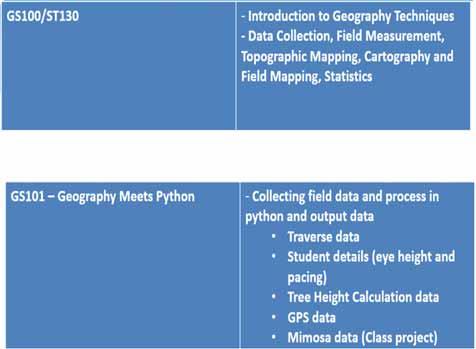
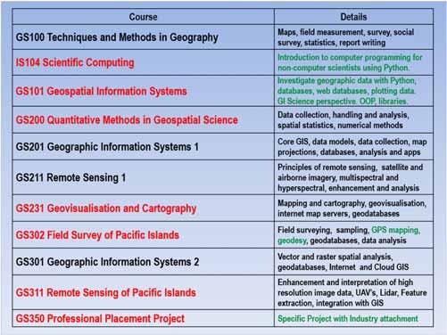
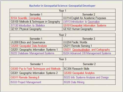
5 GS level units and coverage 5


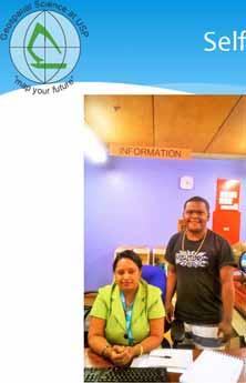
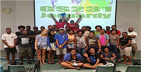
6 2016 Intake of GS Students Selfie with librarian 6


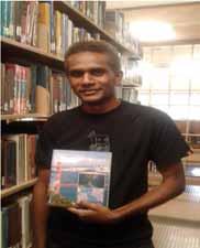
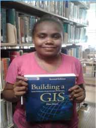

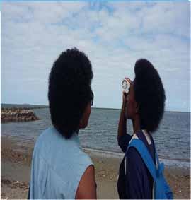
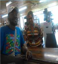
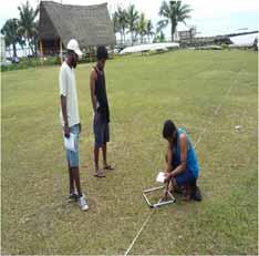
7 Selfie with a GIS book Collecting Traverse/Tree height data 7


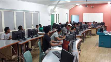
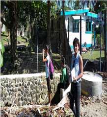
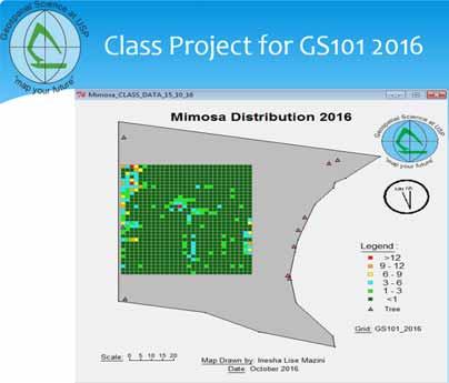
8 Field work Counting mimosa plant Processing data in the lab 8


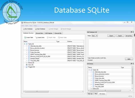

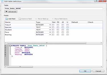
9 Database SQLite Modify Table information 9


10 Python Scripts for each Activity GPS Points Output Proximity 10


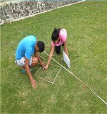
11 Traverse/ Plot Trees location Output Class Project for GS


12 GS231 Cartography and Geovisualisation NEW COURSE In this unit we learnt Modern Professional map making skills, fundamental principles of map design such as map layout, typography, generalization and projection and mapping skills Skills acquired in critiquing other maps 12


13 13


14 GS211 : Remote Sensing 1 Provides students with a foundation of basic remote sensing of the environment. Topics covered were satellite image and aerial photo acquisition, principles of electromagnetic radiation, aerial photography and photogrammetry, geometric and atmospheric correction, image enhancement with band ratio s and digital image processing and classification. Students acquired a hands on learning experience through a variety of exercise conducted in the GIS lab 14


15 GS200 : Quantitative Methods New Course GS200 provides students with a foundation in numerical data analysis and problem solving specific to quantitative research in geography and related disciplines. Building on classical descriptive and inferential statistics the course introduces the student to statistical data analysis in the geographic context 15


")
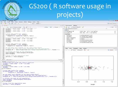
16 GS200 Field Work GS200 ( R software usage in projects) 16

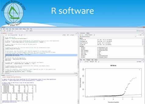

17 R software R software 17
18 GS 302 : Field survey of Pacific Islands New Course offered 2017 Environments unique to the Pacific P3DM (Participatory 3 Dimensional Modelling) Pre and post disaster Mapping Coastal Profiling GNSS Mapping Mangroves, Forest, Plantations and sampling strategies Geodesy dynamic datum, projections and vertical datum GS 311: Remote Sensing of Pacific Islands New Course High Resolution Imagery Satellite Imagery, UAV, Aerial Photography On screen 3D Interpretation Object Orientated Classification 3D Point Cloud Hyperspectral Imaging 18


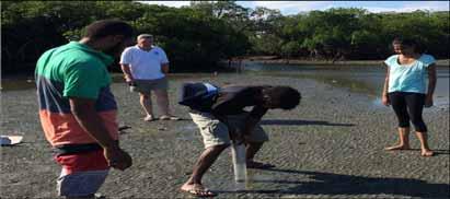
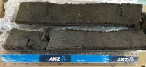
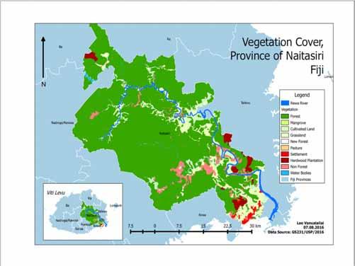
19 Mangrove project Mangrove Coring for Carbon Estimation 19


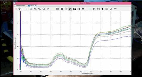
20 Mangrove Spectral Library 20


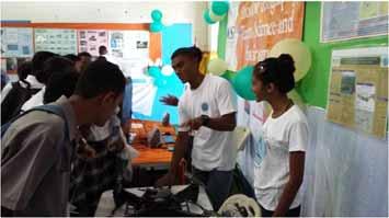


21 USP Open Day Recruiting the next generation of Geospatial Science Thank You 21
22 Please Don't forget to Vote for Best Map Best Poster 22
1. Omit Human and Physical Geography electives (6 credits) 2. Add GEOG 677:Internet GIS (3 credits) 3. Add 3 credits to GEOG 797: Final Project
 2. Add GEOG 677:Internet GIS (3 credits) 3. Add 3 credits to GEOG 797: Final Project") The Department of Geography and the Office of Professional Studies propose to modify the Master of Professional Studies in Geospatial Information Sciences (GIS) as follows: 1. Omit Human and Physical Geography
The Department of Geography and the Office of Professional Studies propose to modify the Master of Professional Studies in Geospatial Information Sciences (GIS) as follows: 1. Omit Human and Physical Geography
WHAT YOU WILL LEARN TODAY
 WHAT YOU WILL LEARN TODAY Overview of the new QGIS Academy Curriculum Background on curriculum development Curriculum alignment with national standards Description of the five GIS courses Details of the
WHAT YOU WILL LEARN TODAY
 WHAT YOU WILL LEARN TODAY Overview of the new GeoAcademy Curriculum Background on curriculum development Curriculum alignment with national standards Description of the five GIS courses Details of the
History & Scope of Remote Sensing FOUNDATIONS
 History & Scope of Remote Sensing FOUNDATIONS Lecture Overview Introduction Overview of visual information Power of imagery Definition What is remote sensing? Definition standard for class History of Remote
Geospatial Intelligence
 Geospatial Intelligence Geospatial analysis has existed as long as humans have made and studied maps but its importance to the intelligence community has skyrocketed in the past several years, with Unmanned
DIPLOMA IN GEOMATICS (NQF Level 6)
") DIPLOMA IN GEOMATICS ( 6) Programme Aims/Purpose: The Diploma in Geomatics programme was purposefully designed to prepare students for a career as survey technician, with specialised knowledge and skills
DIPLOMA IN GEOMATICS ( 6) Programme Aims/Purpose: The Diploma in Geomatics programme was purposefully designed to prepare students for a career as survey technician, with specialised knowledge and skills
Geospatial Science and Technology Model Courses and Certificate:
 Geospatial Science and Technology Model Courses and Certificate: Guidelines and Tools to Align Curriculum to Workforce Needs Ann Johnson Associate Director gisajohnson@delmar.edu Funded by National Science
GIS and Forest Engineering Applications FE 357 Lecture: 2 hours Lab: 2 hours 3 credits
 GIS and Forest Engineering Applications FE 357 Lecture: 2 hours Lab: 2 hours 3 credits Instructor: Michael Wing Assistant Professor Forest Engineering Department Oregon State University Peavy Hall 275
enny Mills chool of Civil ngineering & eosciences ewcastle University
 Future of Surveying: Educating the future geospatial expert A Newcastle University perspective enny Mills chool of Civil ngineering & eosciences ewcastle University Future of surveying: Do we still need
Overview of the William and Mary GIS Certificate Program. Draft Language as of 4/20/2018
 Overview of the William and Mary GIS Certificate Program Draft Language as of 4/20/2018 The Post-Baccalaureate Certificate in Geospatial Information Systems (Science) provides students with a post-baccalaureate
GEOMATICS. Shaping our world. A company of
 GEOMATICS Shaping our world A company of OUR EXPERTISE Geomatics Geomatics plays a mayor role in hydropower, land and water resources, urban development, transport & mobility, renewable energy, and infrastructure
Department of Civil and Environmental Engineering. CE Surveying
 Department of Civil and Environmental Engineering CE 200 - Surveying Instructor: Dr. Laramie Potts Contact: email lpotts@njit.edu Office Hours in 2510 GITC: Wednesday 10:00 12:00 pm Classroom: CULM LEC
Teaching GIS Technology at UW-Superior. Volume 9, Number 8: May 23, 2003
 Teaching GIS Technology at UW-Superior Volume 9, Number 8: May 23, 2003 William Bajjali University of Wisconsin, department of Biology and Earth Science, Superior, WI 54880 Abstract As educators, it is
GIS and Forest Engineering Applications FE 257 Lecture and laboratory, 3 credits
 GIS and Forest Engineering Applications FE 257 Lecture and laboratory, 3 credits Instructor: Michael Wing Associate Professor Forest Engineering, Resources, and Management Oregon State University Crop
GEOGRAPHY (GE) Courses of Instruction
 Courses of Instruction") GEOGRAPHY (GE) GE 102. (3) World Regional Geography. The geographic method of inquiry is used to examine, describe, explain, and analyze the human and physical environments of the major regions of the
GEOGRAPHY (GE) GE 102. (3) World Regional Geography. The geographic method of inquiry is used to examine, describe, explain, and analyze the human and physical environments of the major regions of the
Remote Sensing for Ecosystems
 MODULE GUIDE MSc ENR Remote Sensing for Ecosystems Semester 01 Modul coordinator Lecturers Michael Döring Pascal Ochsner, Diego Tonolla, Diane Whited, Michael Döring Martin Geilhausen Latest update August
Course Syllabus. Geospatial Data & Spatial Digital Technologies: Assessing Land Use/Land Cover Change in the Ecuadorian Amazon.
 Course Syllabus Geospatial Data & Spatial Digital Technologies: Assessing Land Use/Land Cover Change in the Ecuadorian Amazon Co- Instructors Dr. Carlos F. Mena, Universidad San Francisco de Quito, Ecuador
CALIFORNIA STATE POLYTECHNIC UNIVERSITY, POMONA ACADEMIC SENATE ACADEMIC PROGRAMS COMMITTEE REPORT TO THE ACADEMIC SENATE AP
 CALIFORNIA STATE POLYTECHNIC UNIVERSITY, POMONA ACADEMIC SENATE ACADEMIC PROGRAMS COMMITTEE REPORT TO THE ACADEMIC SENATE AP-009-167 BS IN GEOGRAPHY GEOSPATIAL ANALYSIS OPTION Academic Programs Committee
Yrd. Doç. Dr. Saygın ABDİKAN Öğretim Yılı Güz Dönemi
 Yabancı Dil III (YDL285) Introduction to Geomatics Yrd. Doç. Dr. Saygın ABDİKAN 2017-2018 Öğretim Yılı Güz Dönemi 1 géomatique Geo (Earth) + informatics Geodesy + Geoinformatics Geomatics: The mathematics
Open Source Software Education in Texas
 Open Source Software Education in Texas PHILLIP DAVIS / RICHARD SMITH GEOACADEMY The Challenge for Open Source Adoption OPEN SOURCE Less the 5% of US colleges and universities offer training in Free and
ENVIRONMENT AND NATURAL RESOURCES 3700 Introduction to Spatial Information for Environment and Natural Resources. (2 Credit Hours) Semester Syllabus
 Semester Syllabus") ENVIRONMENT AND NATURAL RESOURCES 3700 Introduction to Spatial Information for Environment and Natural Resources COURSE INSTRUCTOR: Dr. Kris Jaeger Assistant Professor 359 Kottman Hall (Mondays and Tuesdays)
ENVIRONMENT AND NATURAL RESOURCES 3700 Introduction to Spatial Information for Environment and Natural Resources COURSE INSTRUCTOR: Dr. Kris Jaeger Assistant Professor 359 Kottman Hall (Mondays and Tuesdays)
INSTITUTE OF AERONAUTICAL ENGINEERING (Autonomous) Dundigal, Hyderabad
 Dundigal, Hyderabad") INSTITUTE OF AERONAUTICAL ENGINEERING (Autonomous) Dundigal, Hyderabad -00 0 CIVIL ENGINEERING TUTORIAL QUESTION BANK Course Name : Remote Sensing and GIS Course Code : A00 Class : IV B. Tech I Semester
INSTITUTE OF AERONAUTICAL ENGINEERING (Autonomous) Dundigal, Hyderabad -00 0 CIVIL ENGINEERING TUTORIAL QUESTION BANK Course Name : Remote Sensing and GIS Course Code : A00 Class : IV B. Tech I Semester
ENVS S102 Earth and Environment (Cross-listed as GEOG 102) ENVS S110 Introduction to ArcGIS (Cross-listed as GEOG 110)
 ENVS S110 Introduction to ArcGIS (Cross-listed as GEOG 110)") ENVS S102 Earth and Environment (Cross-listed as GEOG 102) 1. Describe the fundamental workings of the atmospheric, hydrospheric, lithospheric, and oceanic systems of Earth 2. Explain the interactions
ENVS S102 Earth and Environment (Cross-listed as GEOG 102) 1. Describe the fundamental workings of the atmospheric, hydrospheric, lithospheric, and oceanic systems of Earth 2. Explain the interactions
CERTIFICATE PROGRAM IN
 CERTIFICATE PROGRAM IN GEOGRAPHIC INFORMATION SCIENCE Department of Geography University of Utah 260 S. Central Campus Dr., Rm 270 Salt Lake City, UT 84112-9155 801-581-8218 (voice); 801-581-8219 (fax)
Exit Programme Outcomes (Qualification Outcomes): Upon completion of the Bachelor of Geomatics programme, graduates should be able to:
: Upon completion of the Bachelor of Geomatics programme, graduates should be able to:") BACHELOR OF GEOMATICS (NQF - Level 7) Programme Aims/Purpose: The Bachelor of Geomatics programme is purposefully designed prepare students for a career as professional surveyor, with high level knowledge
BACHELOR OF GEOMATICS (NQF - Level 7) Programme Aims/Purpose: The Bachelor of Geomatics programme is purposefully designed prepare students for a career as professional surveyor, with high level knowledge
https://sites.google.com/a/pdx.edu/gis-2-applications/home
 Page 1 of 5 GIS 2: APPLICATIONS Search this site GEOG 492/592: GIS 2 Syllabus Academic Guidelines Rubrics Presentation Rubric Project Poster Project Proposal Syllabus (PDF) Sitemap GEOG 492/592: GIS 2
Techniques for Science Teachers: Using GIS in Science Classrooms.
 Techniques for Science Teachers: Using GIS in Science Classrooms. After ESRI, 2008 GIS A Geographic Information System A collection of computer hardware, software, and geographic data used together for
BACHELOR OF GEOINFORMATION TECHNOLOGY (NQF Level 7) Programme Aims/Purpose:
 Programme Aims/Purpose:") BACHELOR OF GEOINFORMATION TECHNOLOGY ( Level 7) Programme Aims/Purpose: The Bachelor of Geoinformation Technology aims to provide a skilful and competent labour force for the growing Systems (GIS) industry
BACHELOR OF GEOINFORMATION TECHNOLOGY ( Level 7) Programme Aims/Purpose: The Bachelor of Geoinformation Technology aims to provide a skilful and competent labour force for the growing Systems (GIS) industry
The B.S.G.E. program is accredited by the Engineering Accreditation Commission of ABET,
 Geomatics Engineering The program of study leading to the Bachelor of Science in Geomatics Engineering (B.S.G.E.) deals with designing solutions to measure, map, model, analyze and graphically display
Themes for Geomatics Conference. Geodesy Themes
 Themes for Geomatics Conference Geodesy Themes Geodynamics o Modeling the Deformation of the Earth s Crust o Recent Advances in Geometric Approaches to Deformation Analysis o Monitoring Systems (Sensors
Land Administration and Cadastre
 Geomatics play a major role in hydropower, land and water resources and other infrastructure projects. Lahmeyer International s (LI) worldwide projects require a wide range of approaches to the integration
S/He reports to the Programme Effectiveness Manager. Lead, review and process the development of NO GIS framework and tools.
 GIS Coordinator Location: [Africa] [Ghana] Town/City: Accra Category: Knowledge Management GIS Coordinator To provide leadership and management to cluster staff (of 2 to 3 Area Programs) by ensuring that
GEOG 508 GEOGRAPHIC INFORMATION SYSTEMS I KANSAS STATE UNIVERSITY DEPARTMENT OF GEOGRAPHY FALL SEMESTER, 2002
 GEOG 508 GEOGRAPHIC INFORMATION SYSTEMS I KANSAS STATE UNIVERSITY DEPARTMENT OF GEOGRAPHY FALL SEMESTER, 2002 Course Reference #: 13210 Meeting Time: TU 2:05pm - 3:20 pm Meeting Place: Ackert 221 Remote
Dr. Stephen J. Walsh Department of Geography, UNC-CH Fall, 2007 Monday 3:30-6:00 pm Saunders Hall Room 220. Introduction
 Geographic Information Systems Geography 491 Dr. Stephen J. Walsh Department of Geography, UNC-CH Fall, 2007 Monday 3:30-6:00 pm Saunders Hall Room 220 Introduction Organizations that have a planning,
Geog418: Introduction to GIS Fall 2011 Course Syllabus. Textbook: Introduction to Geographic Information Systems edited by Chang (6th ed.
 Geog418: Introduction to GIS Fall 2011 Course Syllabus AH 1320 3:30 4:45 p.m.tr Instructor: Dr. Shunfu Hu Office: AH1413 Telephone 650-2281 Office hours: 10:00 11:00 a.m. TR or by appointment (shu@siue.edu)
AGRY 545/ASM 591R. Remote Sensing of Land Resources. Fall Semester Course Syllabus
 AGRY 545/ASM 591R Remote Sensing of Land Resources Fall Semester 2005 Course Syllabus Agronomy 545/ASM 591R is a graduate level course designed to teach students how to analyze and interpret remotely sensed
GEOGRAPHY (GEOG) Geography (GEOG) 1. GEOG 11. Laboratory in Physical Geography. 1 Unit Prerequisite(s): GEOG 1; may be taken concurrently.
 Geography (GEOG) 1. GEOG 11. Laboratory in Physical Geography. 1 Unit Prerequisite(s): GEOG 1; may be taken concurrently.") Geography (GEOG) 1 GEOGRAPHY (GEOG) GEOG 1. Physical Geography: The Distribution of Natural Phenomena. 3 Units General Education Area/Graduation Requirement: Physical Science (B1), Summer Introductory
Geography (GEOG) 1 GEOGRAPHY (GEOG) GEOG 1. Physical Geography: The Distribution of Natural Phenomena. 3 Units General Education Area/Graduation Requirement: Physical Science (B1), Summer Introductory
CE 200 Surveying Fall 2017
 Department of Civil and Environmental Engineering CE 200 Surveying Fall 2017 Instructor: Dr. Laramie Potts Contact: email lpotts@njit.edu Office Hours in 2510 GITC: Monday 4:00 5:30 pm Classroom: CULM
GISc Technician model. Diploma in GISc / Geoinformatics NQF level 6. Minimum 240 credits
 GISc Technician model. Diploma in GISc / Geoinformatics NQF level. Minimum 20 credits The workforce and competency requirements of a GISc technicians is defined in terms of the Geomatics Act 19 of 2013,
USGIF Essential Body of Knowledge Competency Areas
 GEOINT Job/Practice Analysis USGIF, in consultation with psychometric consultants and the GEOINT community, executed a job/practice analysis to identify common competencies within the GEOINT profession.
GIS PORTFOLIO MOHAMED MAGDY MOHAMED HUSSAIN GIS ENGINEER. UWF GIS ONLINE CERTIFICATE GIS Internship (GIS4944)
") 2012 GIS PORTFOLIO MOHAMED MAGDY MOHAMED HUSSAIN GIS ENGINEER UWF GIS ONLINE CERTIFICATE GIS Internship (GIS4944) Portfolio Table of Contents Subject... Page Personal statement/mission/philosophy... 1
2012 GIS PORTFOLIO MOHAMED MAGDY MOHAMED HUSSAIN GIS ENGINEER UWF GIS ONLINE CERTIFICATE GIS Internship (GIS4944) Portfolio Table of Contents Subject... Page Personal statement/mission/philosophy... 1
Identifying Audit, Evidence Methodology and Audit Design Matrix (ADM)
") 11 Identifying Audit, Evidence Methodology and Audit Design Matrix (ADM) 27/10/2012 Exercise XXX 2 LEARNING OBJECTIVES At the end of this session participants will be able to: 1. Identify types and sources
11 Identifying Audit, Evidence Methodology and Audit Design Matrix (ADM) 27/10/2012 Exercise XXX 2 LEARNING OBJECTIVES At the end of this session participants will be able to: 1. Identify types and sources
geographic patterns and processes are captured and represented using computer technologies
 Proposed Certificate in Geographic Information Science Department of Geographical and Sustainability Sciences Submitted: November 9, 2016 Geographic information systems (GIS) capture the complex spatial
GIS = Geographic Information Systems;
 What is GIS GIS = Geographic Information Systems; What Information are we talking about? Information about anything that has a place (e.g. locations of features, address of people) on Earth s surface,
GEOSPATIAL ENGINEERING COMPETENCIES. Core Geospatial Competencies
 GEOSPATIAL ENGINEERING COMPETENCIES Core Geospatial Competencies Which Underpin the Chosen Specialism Revision 2018: Security mindedness added to GE CORE 02E The measurement, definition and portrayal,
Programme Study Plan
 Faculty of Social and Life Sciences Programme Study Plan Geographic Information Systems Programme Code: Programme Title: TGLIT Engineering: Surveying Technology and Geographical IT Credits: 180 Programme
Geography (GEOG) Courses
 Courses") Geography (GEOG) 1 Geography (GEOG) Courses GEOG 100. Introduction to Human Geography. 4 (GE=D4) Introduction to the global patterns and dynamics of such human activities as population growth and movements,
Geography (GEOG) 1 Geography (GEOG) Courses GEOG 100. Introduction to Human Geography. 4 (GE=D4) Introduction to the global patterns and dynamics of such human activities as population growth and movements,
SOUTH DAKOTA BOARD OF REGENTS. Academic and Student Affairs ******************************************************************************
 SOUTH DAKOTA BOARD OF REGENTS Academic and Student Affairs AGENDA ITEM: 7 C (4) DATE: June 28-30, 2016 ****************************************************************************** SUBJECT: New Minor:
ARCGIS TRAINING AT KU GIS LABS: INTRODUCTION TO GIS: EXPLORING ARCCATALOG AND ARCGIS TOOLS
 PHASE 1_3 rd SESSION ARCGIS TRAINING AT KU GIS LABS: INTRODUCTION TO GIS: EXPLORING ARCCATALOG AND ARCGIS TOOLS 3 rd SESSION REPORT: 25 TH -27 TH JUNE 2014 SCHOOL OF ENVIRONMENTAL STUDIES COMPUTER LAB
Course overview. Grading and Evaluation. Final project. Where and When? Welcome to REM402 Applied Spatial Analysis in Natural Resources.
 Welcome to REM402 Applied Spatial Analysis in Natural Resources Eva Strand, University of Idaho Map of the Pacific Northwest from http://www.or.blm.gov/gis/ Where and When? Lectures Monday & Wednesday
Introduction to Coastal GIS
 Introduction to Coastal GIS Event was held on Tues, 1/8/13 - Thurs, 1/10/13 Time: 9:00 am to 5:00 pm Location: Roger Williams University, Bristol, RI Audience: The intended audiences for this course are
Cartographic Workshop
 http://lazarus.elte.hu/cet/ Cartographic Workshop One of the roles of the ICA, Commission on Education and Training is to provide member nations with cartographic workshop experiences that enhance the
GIST 4302/5302: Spatial Analysis and Modeling Lecture 1: Overview
 GIST 4302/5302: Spatial Analysis and Modeling Lecture 1: Overview Guofeng Cao www.myweb.ttu.edu/gucao Department of Geosciences Texas Tech University guofeng.cao@ttu.edu Fall 2017 Texas Tech GIS Graduate
Geography and Geographic Information Science (Geog)
") University of North Dakota 1 Geography and Geographic Information Science (Geog) http://www.arts-sciences.und.edu/geography Atkinson, Munski (Graduate Director), Niedzielski, Rundquist, Todhunter, Vandeberg
University of North Dakota 1 Geography and Geographic Information Science (Geog) http://www.arts-sciences.und.edu/geography Atkinson, Munski (Graduate Director), Niedzielski, Rundquist, Todhunter, Vandeberg
Cutting Edge Engineering for Modern Geospatial Systems Rear Admiral Dr. S Kulshrestha, retd
 Cutting Edge Engineering for Modern Geospatial Systems Rear Admiral Dr. S Kulshrestha, retd 11 Jun 2015 GeoIntelligence Asia 2015 The technology would become so pervasive that it becomes a part of you
WESTERN AUSTRALIAN SCHOOL OF MINES AT CURTIN
 Postgraduate Study Spatial Sciences Geographic Surveying and Mapping WESTERN AUSTRALIAN SCHOOL OF MINES AT CURTIN spatial.curtin.edu.au About: Spatial Sciences Xy 2 Curtin University of Technology and
Regional Centre for Mapping of Resources for Development (RCMRD), Nairobi, Kenya. Introduction GIS (2 weeks: 10 days)
, Nairobi, Kenya. Introduction GIS (2 weeks: 10 days)") Regional Centre for Mapping of Resources for Development (RCMRD), Nairobi, Kenya Introduction GIS (: 10 days) Intake Dates: 9 th Jan, 6 th Feb, 6 th Mar, 3 rd April, 8 th May, 5 th June, 3 rd July, 2017
Regional Centre for Mapping of Resources for Development (RCMRD), Nairobi, Kenya Introduction GIS (: 10 days) Intake Dates: 9 th Jan, 6 th Feb, 6 th Mar, 3 rd April, 8 th May, 5 th June, 3 rd July, 2017
LEHMAN COLLEGE OF THE CITY UNIVERSITY OF NEW YORK. 1. Type of Change: Change in Degree Requirements
 Alpha Number: Hegis Code 1214 Program Code: 30600 1. Type of Change: Change in Degree Requirements 2. From: [The curriculum consists of 45 graduate credits and includes core courses, an area of specialization,
Introduction to Coastal GIS
 Held on Tues, 1/8/13 through Thurs, 1/10/13 Location: Roger Williams University, Bristol, RI Audience: The intended audiences for this course are federal and state personnel, municipal staff and officials,
Geographical Information System (GIS) Prof. A. K. Gosain
 Prof. A. K. Gosain") Geographical Information System (GIS) Prof. A. K. Gosain gosain@civil.iitd.ernet.in Definition of GIS GIS - Geographic Information System or a particular information system applied to geographical data
Geographical Information System (GIS) Prof. A. K. Gosain gosain@civil.iitd.ernet.in Definition of GIS GIS - Geographic Information System or a particular information system applied to geographical data
GEOGRAPHY, ENVIRONMENT, AND SUSTAINABILITY (GES)
") Geography, Environment, and Sustainability (GES) 1 GEOGRAPHY, ENVIRONMENT, AND SUSTAINABILITY (GES) GES 102 The Historical Geography of the Western World 3 A study of the geographical factors which combine
Geography, Environment, and Sustainability (GES) 1 GEOGRAPHY, ENVIRONMENT, AND SUSTAINABILITY (GES) GES 102 The Historical Geography of the Western World 3 A study of the geographical factors which combine
MASTER OF APPLIED GEOGRAPHY (M.A.GEO.) MAJOR IN GEOGRAPHIC INFORMATION SCIENCE
 MAJOR IN GEOGRAPHIC INFORMATION SCIENCE") Master of Applied Geography (M.A.Geo.) Major in Geographic Information Science 1 MASTER OF APPLIED GEOGRAPHY (M.A.GEO.) MAJOR IN GEOGRAPHIC INFORMATION SCIENCE Major Program The Master of Applied Geography
Master of Applied Geography (M.A.Geo.) Major in Geographic Information Science 1 MASTER OF APPLIED GEOGRAPHY (M.A.GEO.) MAJOR IN GEOGRAPHIC INFORMATION SCIENCE Major Program The Master of Applied Geography
MASTER OF APPLIED GEOGRAPHY (M.A.GEO.) MAJOR IN GEOGRAPHY RESOURCE AND ENVIRONMENTAL STUDIES
 MAJOR IN GEOGRAPHY RESOURCE AND ENVIRONMENTAL STUDIES") Master of Applied Geography (M.A.Geo.) Major in Geography Resource and Environmental Studies 1 MASTER OF APPLIED GEOGRAPHY (M.A.GEO.) MAJOR IN GEOGRAPHY RESOURCE AND ENVIRONMENTAL STUDIES Major Program
Master of Applied Geography (M.A.Geo.) Major in Geography Resource and Environmental Studies 1 MASTER OF APPLIED GEOGRAPHY (M.A.GEO.) MAJOR IN GEOGRAPHY RESOURCE AND ENVIRONMENTAL STUDIES Major Program
NR402 GIS Applications in Natural Resources
 NR402 GIS Applications in Natural Resources Lesson 1 Introduction to GIS Eva Strand, University of Idaho Map of the Pacific Northwest from http://www.or.blm.gov/gis/ Welcome to NR402 GIS Applications in
ARCGIS TRAINING AT KU GIS LABS: INTRODUCTION TO GIS: EXPLORING ARCCATALOG AND ARCGIS TOOLS
 PHASE 1_4 th SESSION ARCGIS TRAINING AT KU GIS LABS: INTRODUCTION TO GIS: EXPLORING ARCCATALOG AND ARCGIS TOOLS 4 th SESSION REPORT: 30 TH JUNE - 2 ND JULY SCHOOL OF ENVIRONMENTAL STUDIES COMPUTER LAB
CONTENT. 2 Subject Aims 2. 6 Assessment Strategies 5. 7 Maintaining Standards 5. 9 Annexes 8
 CONTENT Page No Foreword III 1 Introduction 1 1.1 Subject Benchmark statement 1 1.2 Nature and Extent of the Subject 2 2 Subject Aims 2 3 Subject Knowledge and Understanding 3 4 Skills and Attitudes 4
ECONOMIC AND SOCIAL COUNCIL 13 July 2007
 UNITED NATIONS E/CONF.98/CRP.34 ECONOMIC AND SOCIAL COUNCIL 13 July 2007 Ninth United Nations Conference on the Standardization of Geographical Names New York, 21-30 August 2007 Item 17(b) of the provisional
Professional Masters Program in Geographic Information Systems Program Description
 University of Washington Department of Geography together with Professional and Continuing Education Professional Masters Program in Geographic Information Systems Program Description The Professional
IDENTIFICATION CRUCIAL COMPONENTS OF NATURAL ECOSYSTEMS
 IDENTIFICATION CRUCIAL COMPONENTS OF NATURAL ECOSYSTEMS Yury S. Otmakhov, Stanislav A. Arbuzov Ph. D., Yury S. Otmakhov; Central Siberian botanical garden Siberian Branch of the Russian Academy of Sciences;
Software. People. Data. Network. What is GIS? Procedures. Hardware. Chapter 1
 People Software Data Network Procedures Hardware What is GIS? Chapter 1 Why use GIS? Mapping Measuring Monitoring Modeling Managing Five Ms of Applied GIS Chapter 2 Geography matters Quantitative analyses
Statement on. Usage of BoK at our institute
 BoK workshop AGILE 2012, Avignon Statement on Usage of BoK at our institute Wolfgang Reinhardt AGIS / Institut für Angewandte Informatik Universität der Bundeswehr München Wolfgang.Reinhardt@unibw.de www.agis.unibw.de
8/28/2011. Contents. Lecture 1: Introduction to GIS. Dr. Bo Wu Learning Outcomes. Map A Geographic Language.
 Contents Lecture 1: Introduction to GIS Dr. Bo Wu lsbowu@polyu.edu.hk Department of Land Surveying & Geo-Informatics The Hong Kong Polytechnic University 1. Learning outcomes 2. GIS definition 3. GIS examples
GERSVIEW: A New Database for Web Mapping
 GERSVIEW: A New Database for Web Mapping William J. Hernández, M.S. Graduate Student Department of Marine Sciences-UPRM Fernando Gilbes, Ph.D. Associate Professor Department of Geology-UPRM Overview Introduction
Remote sensing of forest and land cover at the AUA GIS & Remote Sensing Lab
 AUA GIS AND REMOTE SENSING LAB An initiative of the AUA Acopian Center for the Environment and the AUA College of Science and Engineering http://ace.aua.am/gis-and-remote-sensing Remote sensing of forest
VISUALIZING THE SMART CITY 3D SPATIAL INFRASTRUCTURE GEOSMART ASIA- 30 SEP, 2015
 www.aamgroup.com VISUALIZING THE SMART CITY 3D SPATIAL INFRASTRUCTURE GEOSMART ASIA- 30 SEP, 2015 Agenda AAM What is a Smart City? Data Acquisition 3D Modelling Benefits Questions AAM AAM is a Geospatial
The XXIV FIG International Congress April 2010, Sydney, Australia
 Impact of TEMPUS CARDS Project GIST- CroHE on the new MSc in Geoinformatics Curriculum and on the Implementation of Bologna Process at the Faculty of Geodesy, University of Zagreb, Croatia Damir Medak,
Geologic Remote Imaging - Geology 212 Syllabus Spring 2010
 Geologic Remote Imaging - Geology 212 Syllabus Spring 2010 Dr. Brian Hausback Course Schedule (approximate): Geology Room 1001 Lecture: M-Tu 5:30 6:30 PM Email via SacCT web site Lab: M-Tu 6:50 8:20 PM
3D MAPS SCALE, ACCURACY, LEVEL OF DETAIL
 26 th International Cartographic Conference August 25 30, 2013 Dresden, Germany 3D MAPS SCALE, ACCURACY, LEVEL OF DETAIL Prof. Dr. Temenoujka BANDROVA Eng. Stefan BONCHEV University of Architecture, Civil
Proposal for Revision to the Geographic Information Systems (GIS) Academic Certificate Community College of Philadelphia.
 Academic Certificate Community College of Philadelphia.") Proposal for Revision to the Geographic Information Systems (GIS) Academic Certificate Community College of Philadelphia February 24, 2010 Kathy Smith Chair, Social Science Contributors Christopher Murphy
Proposal for Revision to the Geographic Information Systems (GIS) Academic Certificate Community College of Philadelphia February 24, 2010 Kathy Smith Chair, Social Science Contributors Christopher Murphy
Spatial Analysis Unit Carolina Population Center
 Spatial Analysis Unit Carolina Population Center scan code to link to website: www.cpc.unc.edu/aboutcpc/services/research/spatial Carolina Population Center University Square East 123 West Franklin Street
DEPARTMENT OF GEOGRAPHY B.A. PROGRAMME COURSE DESCRIPTION
 DEPARTMENT OF GEOGRAPHY B.A. PROGRAMME COURSE DESCRIPTION (3 Cr. Hrs) (2340100) Geography of Jordan (University Requirement) This Course pursues the following objectives: - The study the physical geographical
An Introduction to Geographic Information System
 An Introduction to Geographic Information System PROF. Dr. Yuji MURAYAMA Khun Kyaw Aung Hein 1 July 21,2010 GIS: A Formal Definition A system for capturing, storing, checking, Integrating, manipulating,
XXIII CONGRESS OF ISPRS RESOLUTIONS
 XXIII CONGRESS OF ISPRS RESOLUTIONS General Resolutions Resolution 0: Thanks to the Czech Society commends: To congratulate The Czech Society, its president and the Congress Director Lena Halounová, the
CURRICULUM VITAE OF SAMUEL ADU-PRAH
 CURRICULUM VITAE OF SAMUEL ADU-PRAH I. PROFESSIONAL AFFILIATION AND CONTACT INFORMATION A. Lecturer GIS Lab Director-Environmental GIS & Advanced Geospatial Analysis Labs Southern Illinois University Carbondale
FIRE DEPARMENT SANTA CLARA COUNTY
 DEFINITION FIRE DEPARMENT SANTA CLARA COUNTY GEOGRAPHIC INFORMATION SYSTEM (GIS) ANALYST Under the direction of the Information Technology Officer, the GIS Analyst provides geo-spatial strategic planning,
State and National Standard Correlations NGS, NCGIA, ESRI, MCHE
 GEOGRAPHIC INFORMATION SYSTEMS (GIS) COURSE DESCRIPTION SS000044 (1 st or 2 nd Sem.) GEOGRAPHIC INFORMATION SYSTEMS (11, 12) ½ Unit Prerequisite: None This course is an introduction to Geographic Information
GIS certificate; 24th 28th September and 3rd 7th December University of Venda
 ;, TARGET Delegates; Town planners. Geologist, Hydrologist, Hydro-Geologists Botanists Conservationists Land Surveyors, Educators, Researchers, Undergraduate and post-graduate students, companies, Local
APPENDIX B UNDERGRADUATE CATALOG
 APPENDIX B UNDERGRADUATE CATALOG 75 76 Geography-Undergraduate Catalog Richard A. Marston, Head Professors Goodin, J. Harrington, L. Harrington, Marston, Nellis, Paul, and White; Associate Professors Blake,
Conference at a Glance
 Conference at a Glance 8:30 AM MONDAY ROOM 333 ROOM 327/328 ROOM 238 ROOM 296/298 WELCOME and KEYNOTE SPEAKER MICHAEL MILASKA 10 AM BREAK 10:30 AM Web Applications I 12 PM 1:30 PM Intro to R Data Science
BACHELOR OF ARTS GEOGRAPHY
 BACHEL OF ARTS General Education Categories (4-5 credits total) FYS First Year Seminar W-I Written Communication - Level I OC Oral Communication PGR Personal Growth & Responsibility CEA Creative Expression
Educational Qualification No ( No of Positions) 01. Geographic
 01. Geographic") ICZMP, State Project Management Unit-Orissa Plot # 108,Unit VII, Suryanagar,Bhubaneswar 751 003 ICZMP invites applications from eligible candidates for filling up of posts as mentioned below under the
ICZMP, State Project Management Unit-Orissa Plot # 108,Unit VII, Suryanagar,Bhubaneswar 751 003 ICZMP invites applications from eligible candidates for filling up of posts as mentioned below under the
SELF-STUDY FOR THE BACHELOR OF ARTS DEGREE IN GEOLOGY AT THE UNIVERSITY OF HAWAI I AT HILO
 SELF-STUDY FOR THE BACHELOR OF ARTS DEGREE IN GEOLOGY AT THE UNIVERSITY OF HAWAI I AT HILO 1. Is the Geology B.A. degree program organized to meet its objectives? The Bachelor of Arts in Geology program
USING LANDSAT IN A GIS WORLD
 USING LANDSAT IN A GIS WORLD RACHEL MK HEADLEY; PHD, PMP STEM LIAISON, ACADEMIC AFFAIRS BLACK HILLS STATE UNIVERSITY This material is based upon work supported by the National Science Foundation under
GEOGRAPHY COURSES UNDERGRADUATE GRADUATE CERTIFICATE FACULTY. Explanation of Course Numbers. Bachelor's program. Minors.
 GEOGRAPHY The Department of Geography is dedicated to achieving excellence in research and education through the diffusion of geographic knowledge that focuses on the relationships between the physical
GEOGRAPHIC INFORMATION SYSTEMS SPECIALIST 3 DEFINITION:
 Hunterdon County Department of Planning and Land Use Vacancy: Geographic Information Systems Specialist 3 Full Time: 40 Hours per Week Compensation: $42,000.00 per year GEOGRAPHIC INFORMATION SYSTEMS SPECIALIST
Grade 11 Student Electives Guidelines for 2015/16
 Grade 11 Student Guidelines for 2015/16 Overview As part of Abu Dhabi Education Council s continuous improvements efforts towards raising the standard of education in the Emirate of Abu Dhabi, the Cycle
GEOGRAPHICAL INFORMATION SYSTEMS. GIS Foundation Capacity Building Course. Introduction
 GEOGRAPHICAL INFORMATION SYSTEMS. GIS Foundation Capacity Building Course. Introduction In recent times digital mapping has become part and parcel of our daily lives with experience from Google Maps on
Regional Centre for Mapping of Resources for Development (RCMRD), Nairobi, Kenya
, Nairobi, Kenya") Regional Centre for Mapping of Resources for Development (RCMRD), Nairobi, Kenya Introduction to GIS (2 weeks: 10 days) Intakes: 8 th January, 6 th February, 5th March, 3 rd. April 9 th, May 7 th, June
Regional Centre for Mapping of Resources for Development (RCMRD), Nairobi, Kenya Introduction to GIS (2 weeks: 10 days) Intakes: 8 th January, 6 th February, 5th March, 3 rd. April 9 th, May 7 th, June
Geospatial Intelligence
 Geospatial Intelligence Geospatial analysis has existed as long as humans have made and studied maps but its importance to the intelligence community has skyrocketed in the past several years, with Unmanned
Remote Sensing and EO activities at the University of Turku
 Remote Sensing and EO activities at the University of Turku Niina Käyhkö Associate Professor Department of Geography and Geology GEO meeting/syke May 23rd, 2018 Geospatial competence at the University