Backscatter and Seafloor Acoustical Properties of Wellington Harbour; Preliminary Results and Potential
|
|
|
- Rodney Beasley
- 5 years ago
- Views:
Transcription


")
1 Backscatter and Seafloor Acoustical Properties of Wellington Harbour; Preliminary Results and Potential Geoffroy Lamarche 1, Xavier Lurton 2, Jean-Marie Augustin 2, Anne- Laure Verdier 1 and Arne Pallentin 1 1: National Institute of Water and Atmospheric Research (NIWA) 2: Institute Français de Recherche pour l Exploitation de la Mer (IFREMER)
2 Overview Survey details SonarScope in short Compensation how it works and how do the results look? Calibration did it work? Segmentation does it align with what I see?
3 Wellington Harbour Survey Cooperation between NIWA, DoC, WRC Collected in opportunistic fashion in 07/ 08 Platform: NIWA R/V Pelorous Multi-Beam: Kongsberg EM3000D Attitude Sensor: Applanix PosMV Mk 3 Original processing in CARIS HIPS ~80km 2 coverage
4 SonarScope basics Developed by Jean-Marie Augustin at IFREMER MatLab based, run usually compiled Ability to read, analyze and process a large variety of sounder formats Profiles of emission & angular reflectivity Mosaics Compensation Segmentation

5 Bathymetry Depth in image shown is -1.5m to 32m Focusing later on two areas Shoal SE of Makaro/Ward Island Oriental Bay

6 Backscatter Beam Average Processed as part of the original survey data processing Using CARIS HIPS/SIPS Beam Average
7 SonarScope Snippets Calculated in SonarScope from raw (.all) files) Produces a time series signal Shown here is the compensated image

8 Bathymetry/Backscatter Details

9 SonarScope Compensation Statistics computed on a selected line, partial or full Produces a curve describing swath average This average is deducted from lines in project
10 SonarScope Compensation Nadir effect is reduced Problematic in areas of high variability Can be overcome by compensating per region
11 Backscatter Calibration of a EM3000D Trial of curve fitting in SonarScope To date no success Too many factors effecting backscatter Plus dual-head configuration Will keep looking, but better to work on simpler configurations first

12 Sediment Sample Distribution NIWA has several hundred samples from the harbour Taken between the 50 s and 90 s Shown samples have sediment composition data

13 Sediment Distribution Mud dominated samples in the basin Sand dominated samples on shoal areas Gravel influenced samples on rocky outcrops and close to coast
14 Carbonate Component Carbonate percentage used for size of pie chart Indication that sand and gravel dominated samples are also carbonate rich >> biogenic component?
15 Grain Size Prediction Simple trial to show predicted sediment composition by cogrigging Based on grain size distribution Not yet tested against samples (test data set)

16 Sediment Backscatter Correlation Sediment composition is reflected in the backscatter Sample distribution is result of historic projects Not all backscatter facies reflected in sample set

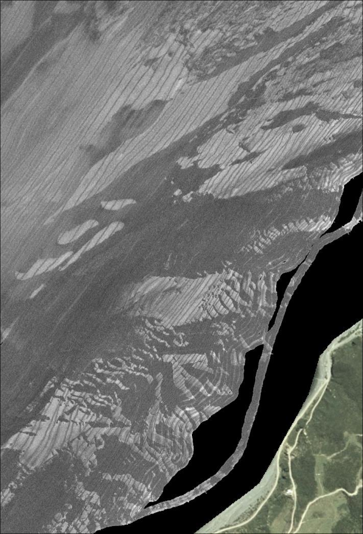
17 Makaro/Ward Island: Backscatter & Samples Shoal area SE of Makaro/Ward Island Relatively few sediment samples Sand dominant grain size Excellent display of seafloor features

18 Makaro/Ward Island: Backscatter Segmentation Segmentation process based on Imen Karoui's MSc thesis An automated segmentation of acoustically similar areas
19 Makaro/Ward Island: Backscatter Segmentation Segmentation process based cooccurrence of pixel values Here we used five classes Originally six, but two classes were too similar

20 Makaro/Ward Island: Backscatter Segmentation

21 Makaro/Ward Island: Backscatter Segmentation
 Sediment distribution again well reflected in")
22 Oriental Bay: Backscatter & Sediment Samples Oriental Bay and Aotea Quay Large human impact (land reclamation, ship traffic) Sediment distribution again well reflected in backscatter

23 Oriental Bay: Segmentation Same segmentation classes as for the Makaro/Ward Island area Swath overlap issues more prominent I n the flat seafloor


24 Oriental Bay/ Aotea Quay: Segmentation & Backscatter
25 Summary Snippet computation in SonarScope gives excellent backscatter imagery Compensation improves visual impression and cleanness greatly Segmentation in SonarScope produces good correlation Preliminary sediment sample correlation with backscatter and segmentation looks promising, but more work is needed
Backscatter calibration for MBES Project Shom / Ifremer
 Backscatter calibration for MBES Project Shom / Ifremer Christophe Vrignaud Sophie Loyer Julian Le Deunf (Shom) Xavier Lurton - Jean-Marie Augustin Laurent Berger (Ifremer) INTRODUCTION The main need:
Using remote-sensed data for quantitative shallow water habitat mapping in New Zealand
 Using remote-sensed data for quantitative shallow water habitat mapping in New Zealand Friday 24 February 2012 Geoffroy Lamarche National Institute of Water and Atmospheric Research Wellington with substantial
CHAPTER 6 RESULTS FIGURE 8.- DATA WORK FLOW FOR BACKSCATTER PROCESSING IN HYPACK
 CHAPTER 6 RESULTS 6.1. Backscatter Workflow Comparison Currently, INOCAR owns and operates RESON and Kongsberg multibeam systems for nearshore surveys. The RESON system is integrated with HYPACK Hysweep
MBES BS calibration on reference patch areas using singlebeam calibrated data
 MBES BS calibration on reference patch areas using singlebeam calibrated data Southampton, U.K. Brussels, Belgium NOC 3 FPS Economy 2, Continental Shelf Service D. Eleftherakis 1, X. Lurton 1, J.M. Augustin
Multibeam Echosounder Mapping to Identify Seafloor Habitats
 Multibeam Echosounder Mapping to Identify Seafloor Habitats Helen NEIL, Kevin MACKAY, John MITCHELL, Arne PALLENTIN, New Zealand Key words: Cartography; Bathymetry; Remote sensing; Ecosystem Classification
Common Dataset Information
 Common Dataset Information Introduction The Common Dataset is a defining feature of the Shallow Survey conferences and consists of a series of surveys conducted over a common area of seabed using a variety
Multibeam echo-sounder mapping to identify seafloor habitats northwest of D'Urville Island. Prepared for the Marlborough District Council
 Multibeam echo-sounder mapping to identify seafloor habitats northwest of D'Urville Island Prepared for the Marlborough District Council June 2015 Prepared by: Helen Neil Arne Pallentin John Mitchell Tim
Recent developments in multi-beam echo-sounder processing at the Delft
 Recent developments in multi-beam echo-sounder processing at the Delft University of Technology Prof. Dr. Dick G. Simons Acoustic Remote Sensing Group, Faculty of Aerospace Engineering, Delft University
Acoustic seafloor mapping systems. September 14, 2010
 Acoustic seafloor mapping systems September 14, 010 1 Delft Vermelding Institute onderdeel of Earth organisatie Observation and Space Systems Acoustic seafloor mapping techniques Single-beam echosounder
MAPPING FISHERIES HABITATS BY ENHANCED MULTIBEAM ACOUSTIC DATA IN ALASKA
 1.0 ABSTRACT MAPPING FISHERIES HABITATS BY ENHANCED MULTIBEAM ACOUSTIC DATA IN ALASKA Jerry Wilson Fugro Pelagos, Inc. Bill Gilmour Fugro Pelagos, Inc. Dr. Gary Greene Moss Landing Marine Laboratories
Coastal Zone Mapping and Imaging Lidar (CZMIL)
") Coastal Zone Mapping (CZMIL) Shallow Survey 2012 Wellington, New Zealand Christopher L. Macon U.S. Army Corps of Engineers, Mobile District Joint Airborne Lidar Bathymetry Technical Center of expertise
Coastal Zone Mapping (CZMIL) Shallow Survey 2012 Wellington, New Zealand Christopher L. Macon U.S. Army Corps of Engineers, Mobile District Joint Airborne Lidar Bathymetry Technical Center of expertise
Sediment classification from multibeam backscatter images using simple histogram analysis
 Sediment classification from multibeam backscatter images using simple histogram analysis Rozaimi Che Hasan 1,2, Mohd Razali Mahmud 3 and Shahrin Amizul Shamsudin 1 1 UTM Razak School of Engineering and
MLLW and the NAD83 Ellipsoid: An Investigation of Local Offsets and Trends Using PPK and Gauge Derived Water Surfaces.
 MLLW and the NAD83 Ellipsoid: An Investigation of Local Offsets and Trends Using PPK and Gauge Derived Water Surfaces. Abstract: Authors Doug Lockhart, Fugro Pelagos, Inc. Andy Orthmann, Fugro Pelagos,
7.0 Project Reports 7.1 Geophysical Mapping of Submarine Environments
 7.0 Project Reports 7.1 Geophysical Mapping of Submarine Environments Suzanne Carbotte, Robin Bell, Roger Flood 7.1.1 METHODS In April 2000 we deployed the R/V Onrust, operated by MSRC at SUNY Stony Brook,
The data for Practical 2 is available for download at the dropbox link embedded in the I sent you.
 EGM310 UNDERWATER REMOTE SENSING PRACTICALS RORY QUINN PRACTICAL 2: MBES BACKSCATTER DATA Aim of practical To gain confidence in interpreting backscatter data derived from multi-beam echo-sounder surveys,
Smart Survey Approach: Multibeam Echosounder and Integrated Water Column Data as an Added Value for Seep Hunting
 Smart Survey Approach: Multibeam Echosounder and Integrated Water Column Data as an Added Value for Seep Hunting HYDRO 2016 8 November 2016 Marco Filippone Introduction, Multibeam Sonars & water column
Programme. Monday 20 February
 Programme Monday 20 February 8:30am 12:30pm 1:00pm - 5:00pm 5:00pm Hosted Workshops: (Telstra Clear Centre, Te Papa) CARIS: New methods for processing bathymetric and sonar data RESON: PDS2000 software
FINMARINET: Inventories and Planning for the Marine Natura 2000 Network in Finland. A.2 Geological inventories of the seafloor Final Report
 LIFE07 NAT/FIN/000151 FINMARINET: Inventories and Planning for the Marine Natura 2000 Network in Finland A.2 Geological inventories of the seafloor Final Report Geological Survey of Finland, GTK 1. Introduction
SEABED CLASSIFICATION FROM MULTIBEAM ECHOSOUNDER BACKSCATTER DATA USING WAVELET TRANSFORMATION AND NEURAL NETWORK APPROACH
 SEABED CLASSIFICATION FROM MULTIBEAM ECHOSOUNDER BACKSCATTER DATA USING WAVELET TRANSFORMATION AND NEURAL NETWORK APPROACH Jaroslaw Tegowski a,b, Jaroslaw Nowak a, Mateusz Moskalik c, Kazimierz Szefler
Changes in Geomorphology and Backscatter Patterns in Mount Misery Shoal, Long Island Sound as Revealed through Multiple Multibeam Surveys
 Changes in Geomorphology and Backscatter Patterns in Mount Misery Shoal, Long Island Sound as Revealed through Multiple Multibeam Surveys Laurie A. Zaleski Laurie.Zaleski@msrc.sunysb.edu, Roger D. Flood
Benthic habitat mapping using multibeam sonar
 Benthic habitat mapping using multibeam sonar Iain M. Parnum 1, Alexander Gavrilov 1 and Justy Siwabessy 2 1. Centre for Marine Science and Technology, Curtin University, Perth, Australia 2. Geoscience
Acoustic classification of fine-scale sediment variability and interconnection with benthic habitats of the Eckernförde Bay, Kiel
 7 th Workshop Seabed Acoustics, Rostock, November 19/20, 2015 P11-1 Acoustic classification of fine-scale sediment variability and interconnection with benthic habitats of the Eckernförde Bay, Kiel Evangelos
WP. 4 Detection and characterization of CWA dumpsites. Zygmunt Klusek Ulf Olsson
 WP. 4 Detection and characterization of CWA dumpsites Zygmunt Klusek Ulf Olsson Stockholm 02.03.2013 Zygmunt Klusek & Ulf Olsson WP. 4 Detection and characterization of CWA dumpsites 0.2.03.2013 This page
RESULTS OF THE 2007 MULTIBEAM BATHYMETRIC AND BACKSCATTER SURVEYS AT THE HISTORIC AREA REMEDIATION SITE
 RESULTS OF THE 2007 MULTIBEAM BATHYMETRIC AND BACKSCATTER SURVEYS AT THE HISTORIC AREA REMEDIATION SITE FINAL DRAFT December 2007 Contract No. SAIC Project No. 01-0236-08-6326-400 SAIC Report No. 724 Prepared
3.2 Geophysical Habitat Mapping
 APPENDIX 3 GEOPHYSICS Prepared for: Namibian Marine Phosphate (Pty) Ltd. Prepared by: Jeremy Midgley September 2014 Mr Jeremy Midgley Pr.Sci.Nat J. Midgley & Associates PO Box 110 Constantia 7806 South
Topic: Bathymetric Survey Techniques. (a) Single-beam echo-sounders (SBES) (b) Multi-beam echo-sounders (MBES)
 Single-beam echo-sounders (SBES) (b) Multi-beam echo-sounders (MBES)") Topic: Bathymetric Survey Techniques (a) Single-beam echo-sounders (SBES) (b) Multi-beam echo-sounders (MBES) Bathymetry is the measurement of water depths - bathymetry is the underwater equivalent of
Topic: Bathymetric Survey Techniques (a) Single-beam echo-sounders (SBES) (b) Multi-beam echo-sounders (MBES) Bathymetry is the measurement of water depths - bathymetry is the underwater equivalent of
Using the MBES for classification of riverbed sediments
 Acoustics 8 Paris Using the MBES for classification of riverbed sediments A. Amiri-Simkooei a, M. Snellen a and D. G Simons b a Acoustic Remote Sensing Group, Delft Institute of Earth Observation and Space
Work Package 5: Signal Processing and Seafloor Classification
 Work Package 5: Signal Processing and Seafloor Classification Jarosław Tęgowski and Karolina Trzcińska Marine Geophysics Lab. Institute of Oceanography University of Gdańsk, Poland Kick-Off Meeting, Kiel,
Storm Response Surveying with Phase- Measuring Bathymetric Sidescan Sonar
 Storm Response Surveying with Phase- Measuring Bathymetric Sidescan Sonar Kevin Jerram and Val Schmidt Center for Coastal and Ocean Mapping Durham, New Hampshire Two sunken subway cars and adjacent bedforms
Image Services Providing Access to Scientific Data at NOAA/NCEI
 Image Services Providing Access to Scientific Data at NOAA/NCEI Jesse Varner Cooperative Institute for Research in Environmental Sciences (CIRES), University of Colorado John Cartwright NOAA National Centers
Remote Identification of Seafloor Properties in Denied Areas
 Remote Identification of Seafloor Properties in Denied Areas Larry Mayer, Luciano Fonseca, and Thomas Weber Center for Coastal and Ocean Mapping University of New Hampshire Durham, NH 03824 Phone: (603)
Mound Study Project Cape Fear, North Carolina Report Summary VIMS Reports: CHSD to CHSD EHI Project No
 Mound Study Project Cape Fear, North Carolina Report Summary VIMS Reports: CHSD-2003-02 to CHSD-2003-06 EHI Project No. 6000.21 February 2003 Final VIMS Report CHSD-2003-01 Prepared for Evans-Hamilton,
Morphology of Canal Isabela in the Galapagos Islands
 Morphology of Canal Isabela in the Galapagos Islands Allison Cougan University of Washington School of Oceanography Box 357940 Seattle, WA 98195 allcoug@u.washington.edu 206.427.9084 November 23, 2005
Monitoring Near-Shore Bathymetry Using a Multi- Image Satellite-Derived Bathymetry Approach
 University of New Hampshire University of New Hampshire Scholars' Repository Center for Coastal and Ocean Mapping Center for Coastal and Ocean Mapping 3-2015 Monitoring Near-Shore Bathymetry Using a Multi-
12/11/2013& egm502 seafloor mapping
 egm502 seafloor mapping lecture 13 multi-beam echo-sounders The majority of the current charts of the ocean floors have been produced from single beam echo-sounder data. Even though these data have been
Geochemistry, Geophysics, Geosystems. Supporting Information for
 Geochemistry, Geophysics, Geosystems Supporting Information for Segment-scale variations in seafloor volcanic and tectonic processes from multibeam sonar imaging, Mid-Atlantic Ridge Rainbow region (35º45-36º35
H.A.R.S. PRA #1 (Historic Area Remediation Site)
") H.A.R.S. PRA #1 (Historic Area Remediation Site) 2009 Multibeam Bathymetry TABLE OF CONTENTS Page LIST OF TABLES 2 LIST OF FIGURES 3 1.0 INTRODUCTION 4 2.0 OBJECTIVE 4 3.0 PROCEDURE 4 3.1 DATA ACQUISITION
H.A.R.S. PRA #1 (Historic Area Remediation Site) 2009 Multibeam Bathymetry TABLE OF CONTENTS Page LIST OF TABLES 2 LIST OF FIGURES 3 1.0 INTRODUCTION 4 2.0 OBJECTIVE 4 3.0 PROCEDURE 4 3.1 DATA ACQUISITION
Rock Boulder RockSand 1 RockSand 2 RockSand 3 Sand
 Figure 15. Histogram comparison of ROV observed primary substrates determined from 33,605 dgps positions to RoxAnn seabed classification. Pie charts represent the percentage of ROV modified primary substrate
Changes in bottom morphology of Long Island Sound near Mount Misery Shoal as observed through Repeated Multibeam Surveys
 Changes in bottom morphology of Long Island Sound near Mount Misery Shoal as observed through Repeated Multibeam Surveys Laurie A. Zaleski Laurie.Zaleski@msrc.sunysb.edu Roger D. Flood rflood@notes.cc.sunysb.edu
GEOPHYSICAL TECHNIQUES FOR MARITIME ARCHAEOLOGICAL SURVEYS. Abstract
 GEOPHYSICAL TECHNIQUES FOR MARITIME ARCHAEOLOGICAL SURVEYS Mark Lawrence, Wessex Archaeology, Salisbury, UK, Ian Oxley, English Heritage, Portsmouth, UK, C. Richard Bates, University of St. Andrews, St.
MONITORING OF VENICE INLET CHANNELS. Sharing knowledge to make data available for everyone
 MONITORING OF VENICE INLET CHANNELS Sharing knowledge to make data available for everyone Introduction What does hydrography really mean? IHO defines hydrography as a description of the physical features
Lecture Outlines PowerPoint. Chapter 13 Earth Science 11e Tarbuck/Lutgens
 Lecture Outlines PowerPoint Chapter 13 Earth Science 11e Tarbuck/Lutgens 2006 Pearson Prentice Hall This work is protected by United States copyright laws and is provided solely for the use of instructors
High-frequency seafloor acoustic backscatter from coastal marine habitats of Australia
 High-frequency seafloor acoustic backscatter from coastal marine habitats of Australia Iain Parnum (1) and Alexander Gavrilov (1) (1) Centre for Marine Science and Technology, Curtin University, Perth,
IDENTIFICATION OF SEAFLOOR HABITATS IN COASTAL SHELF WATERS USING A MULTIBEAM ECHOSOUNDER
 IDENTIFICATION OF SEAFLOOR HABITATS IN COASTAL SHELF WATERS USING A MULTIBEAM ECHOSOUNDER Parnum, I.M.*(1) & (2), Siwabessy, P.J.W. (1) & (2) and Gavrilov A.N. (1) (1) Centre for Marine Science and Technology,
US ARMY CORPS OF ENGINEERS New England District BUILDING STRONG
 US ARMY CORPS OF ENGINEERS New England District STUDIES Sediment Sampling Biological Sampling (benthic community analysis) Hydroacoustic Surveys (side scan sonar, bathymetry) Remotely Operated Vehicle
Submarine Mapping using Multibeam Bathymetry and and Acoustic Backscatter: Illuminating the Seafloor
 4. Conclusions A software-hardware partitioning proposal for designing an embedded digital system for fingerprint identification has been presented. The paper describes the most important stages involved
NIWA Client Report: WLG July 2004 NIWA Project: DOC04403
 BENTHIC HABITATS OFF KAIKOURA - Physical characteristics from side-scan sonar and depth imagery NIWA Client Report: WLG2004-50 July 2004 NIWA Project: DOC04403 BENTHIC HABITATS OFF KAIKOURA - Physical
Habitat Mapping in The Hauraki Gulf Marine Park. Dan Breen
 Habitat Mapping in The Hauraki Gulf Marine Park Dan Breen Outline 1. Intro Habitat mapping 2. Coastal marine habitats and marine protected areas in the New Zealand Territorial Sea: a broad scale gap analysis
A National Outer Continental Shelf Sand / Sediment Inventory
 A National Outer Continental Shelf Sand / Sediment Inventory Sand Resource Areas Lease Areas Lora Turner December 15, 2016 Restoring and Protecting Our Nation s Coasts through Stewardship of OCS Resources
Indonesia Frontier Basin SUNDA (SU-08) NON-EXCLUSIVE 2-D SURVEY 3084km
 NON-EXCLUSIVE 2-D SURVEY 3084km") Indonesia Frontier Basin SUNDA (SU-08) NON-EXCLUSIVE 2-D SURVEY 3084km SEISMIC ACQUISITION PARAMETERS Acquisition Date: January - March 2008 Vessel: M/V Osprey Explorer Shooting Orientation: Strike-Dip
Indonesia Frontier Basin SUNDA (SU-08) NON-EXCLUSIVE 2-D SURVEY 3084km SEISMIC ACQUISITION PARAMETERS Acquisition Date: January - March 2008 Vessel: M/V Osprey Explorer Shooting Orientation: Strike-Dip
Monitoring The Sand Extraction On The Belgian Continental Shelf
 Monitoring The Sand Extraction On The Belgian Continental Shelf Methodology, Results And Expectations K. Degrendele and M. Roche Within the framework of a sustainable exploitation of the mineral resources
River bed classification using multi-beam echo-sounder backscatter data
 River bed classification using multi-beam echo-sounder backscatter data Niels Kinneging Mirjam Snellen Dimitrios Eleftherakis Dick Simons Erik Mosselman Arjan Sieben 13 November 2012 transport water management
Observations of the Spatial and Temporal Variability of Wave Formed Ripples from the 2007 Martha's Vineyard RipplesDRI Experiment
 Observations of the Spatial and Temporal Variability of Wave Formed Ripples from the 2007 Martha's Vineyard RipplesDRI Experiment Dr. Peter Traykovski Woods Hole Oceanographic Institution Applied Ocean
R/V Kaiyo cruise report KY10-04
 R/V Kaiyo cruise report KY10-04 6-9 th March, 2010 Teishi Knoll, Sagami Bay Underwater Technology Research Centre Institute of Industrial Science The University of Tokyo Cruise summary Contents 1. Purpose
Analysis of Physical Oceanographic Data from Bonne Bay, September 2002 September 2004
 Physics and Physical Oceanography Data Report -1 Analysis of Physical Oceanographic Data from Bonne Bay, September September Clark Richards and Brad deyoung Nov. 9 Department of Physics and Physical Oceanography
The Bathymetry of the Central Mediterranean Sea in the framework of the EMODnet project a case study of bathymetric data integration and processing.
 The Bathymetry of the Central Mediterranean Sea in the framework of the EMODnet project a case study of bathymetric data integration and processing. Federica Foglini & Marzia Rovere CNR-ISMAR Institute
Benthic habitat mapping: a synopsis of methodologies and approaches. Dr. Craig Brown University of Ulster
 Benthic habitat mapping: a synopsis of methodologies and approaches Dr. Craig Brown University of Ulster Technological advances in remote sensing Insitu sampling Improving technology Single beam acoustics/video
Mission of the Network
 Mission of the Network The purpose of the COMREN is to Develop research activities, Achieve technology transfer to the Industry, Develop and run educational programs, in liaison with government agencies,
The Ocean Floor Earth Science, 13e Chapter 13
 The Ocean Floor Earth Science, 13e Chapter 13 Stanley C. Hatfield Southwestern Illinois College The vast world ocean Earth is often referred to as the blue planet Seventy-one percent of Earth s surface
Decline of Lake Michigan-Huron Levels Caused by Erosion of the St. Clair River
 Decline of Lake Michigan-Huron Levels Caused by Erosion of the St. Clair River W.F. & Associates Coastal Engineers (in association with Frank Quinn) April 13, 2005 Outline Problem Definition Understanding
Evaluating the USACE's NCMP for NOAA charting operations
 University of New Hampshire University of New Hampshire Scholars' Repository Center for Coastal and Ocean Mapping Center for Coastal and Ocean Mapping 8-2013 Evaluating the USACE's NCMP for NOAA charting
IMPLEMENTATION OF A BATHYMETRY DATABASE FOR GEOSCIENCE AUSTRALIA
 IMPLEMENTATION OF A BATHYMETRY DATABASE FOR GEOSCIENCE AUSTRALIA FELLINGER Christian & KRUIMEL Daniel, CARIS Asia Pacific, Suite 1 Innovation House, Mawson Lakes Boulevard, Mawson Lakes, SA, Australia
Missions from MARS: Marine Autonomous and Robotic Systems - current and future science applications
 Missions from MARS: Marine Autonomous and Robotic Systems - current and future science applications Dr Russell B Wynn (MARS Chief Scientist, Head of NOC Marine Geoscience) Marine Autonomous and Robotic
2) re-positioning of the SSS data, 3) individuation of geomorphological features and morphometrical parameters correlated to instability phenomena.
 re-positioning of the SSS data, 3) individuation of geomorphological features and morphometrical parameters correlated to instability phenomena.") HIGH-RESOLUTION SIDE SCAN SONAR AND MULTIBEAM DATA PROCESSING AND MERGING TO STUDY SUBMARINE INSTABILITY PHENOMENA ON VOLCANIC ISLANDS (PONTINE, CAMPANIAN AND AEOLIAN ARCHIPELAGOS) A. BOSMAN Extended abstract:
HIGH-RESOLUTION SIDE SCAN SONAR AND MULTIBEAM DATA PROCESSING AND MERGING TO STUDY SUBMARINE INSTABILITY PHENOMENA ON VOLCANIC ISLANDS (PONTINE, CAMPANIAN AND AEOLIAN ARCHIPELAGOS) A. BOSMAN Extended abstract:
River bed classification using multi-beam echo-sounder backscatter data. Niels KINNEGING Rijkswaterstaat Centre for Water Management
 River bed classification using multi-beam echo-sounder backscatter data Niels KINNEGING Rijkswaterstaat Centre for Water Management Mirjam SNELLEN Delft University of Techonology Dimitrios ELEFTHERAKIS
The use of MIKE21 to study the. barrier beach system of Inner Dingle Bay, Co. Kerry, Ireland. Dr. Michael O Shea Malachy Walsh and Partners
 The use of MIKE21 to study the morphodynamic evolution of the mid-bay barrier beach system of Inner Dingle Bay, Co. Kerry, Ireland Dr. Michael O Shea Malachy Walsh and Partners Contents Why Study Morphodynamics
SonTek HydroSurveyor M9 now powered by HYPACK! CASE STUDY: USGS HYDROSURVEYOR SURVEY OF FENA VALLEY RESERVOIR, GUAM
 SonTek HydroSurveyor M9 now powered by HYPACK! CASE STUDY: USGS HYDROSURVEYOR SURVEY OF FENA VALLEY RESERVOIR, GUAM Presenters Harold Orlinsky General Manager HYPACK Isaac Jones Product manager, SonTek
Increased-resolution Bathymetry in the Southeast Indian Ocean
 ARTICLE MH370 SEARCH DATA Increased-resolution Bathymetry in the Southeast Indian Ocean The disappearance of Malaysian Airlines flight MH370 on 8 March 2014 led to a deep ocean search effort of unprecedented
Kyle Griebel NRS 509 Dr. August & Dr. Wang GIS and remote sensing in Seafloor mapping
 GIS and remote sensing in Seafloor mapping Introduction to seafloor mapping Seafloor maps have a wide variety of uses for scientists and coastal planning needs. Some of these uses include biological assessment
COMPARATIVE STUDY BETWEEN FLAT AND UNIFORM BOTTOM ASSUMPTIONS FOR SNIPPET IMAGERIES IN HYDROGRAPHIC APPLICATIONS
 COMPARATIVE STUDY BETWEEN FLAT AND UNIFORM BOTTOM ASSUMPTIONS FOR SNIPPET IMAGERIES IN HYDROGRAPHIC APPLICATIONS Rubasingam R., Mahmud M.R. and Gunathilaka M.D.E.K. Hydrographic Research and Training Office,
Inspection of Waterfront Facilities Using Vessel-Based Remote Sensing Mitchell, Del Bello, Suarez
 Inspection of Waterfront Facilities Using Vessel-Based Remote Sensing Mitchell, Del Bello, Suarez American Association of Port Authorities Facilities Engineering Conference October 20-22, 2015 Waterfront
4) Treyson Gillespie and Dr. Leslie Sautter Bathymetric Analysis of Glaciokarstic Limestone Substrate on the Western Irish Coast
 Treyson Gillespie and Dr. Leslie Sautter Bathymetric Analysis of Glaciokarstic Limestone Substrate on the Western Irish Coast") 2017 US Hydro Conference Academic Poster Abstracts by College of Charleston BEAMS Program students 1) Evalynn Barbare and Dr. Leslie Sautter Using Multibeam Sonar to Identify Potential Deep Sea Coral Habitat
2017 US Hydro Conference Academic Poster Abstracts by College of Charleston BEAMS Program students 1) Evalynn Barbare and Dr. Leslie Sautter Using Multibeam Sonar to Identify Potential Deep Sea Coral Habitat
High-frequency multibeam echosounder classification for rapid environmental assessment
 High-frequency multibeam echosounder classification for rapid environmental assessment K. Siemes a, M. Snellen a, D. G Simons b, J.-P. Hermand c, M. Meyer d,c and J.-C. Le Gac e a Acoustic Remote Sensing
Geophysics the use of geology, laboratory & field experiments, mathematics, and instruments to study: Earthquakes and Volcanoes seismometers,
 Geophysics the use of geology, laboratory & field experiments, mathematics, and instruments to study: Earthquakes and Volcanoes seismometers, tiltmeters, EDM, remote sensing, Energy: oil, gas, hydrothermal
Results of the RV Simon Stevin EM2040 Sea Acceptance Test and comparison with EM3002D data from the HS Ter Streep and RV Belgica.
 Results of the RV Simon Stevin EM2040 Sea Acceptance Test and comparison with EM3002D data from the HS Ter Streep and RV Belgica. Cattrijsse Andre, Degrendele Koen, De Mol Lies, Naudts Lieven, Roche Marc,
Earth / Environmental Science. Ch. 14 THE OCEAN FLOOR
 Earth / Environmental Science Ch. 14 THE OCEAN FLOOR The Blue Planet Nearly 70% of the Earth s surface is covered by the global ocean It was not until the 1800s that the ocean became an important focus
SUT WA Research Night
 SUT WA Research Night An introduction to acoustic seafloor observation and geostatistical data interpolation Elizabeth Mair BSc (GIS) Honours Curtin University Contents Project Introduction Methodology
PRESENTATION TITLE. Regional Sediment Management Application of a Coastal Model at the St. Johns River Entrance BUILDING STRONG
 PRESENTATION TITLE Regional Sediment Management Application of a Coastal Model at the St. Johns River Entrance Steven Bratos Senior Coastal Engineer U.S. Army Corps of Engineers Jacksonville District February
Introduction to Acoustic Remote Sensing and Seafloor Mapping (AE4-E13) May 19, 2010
 May 19, 2010") Introduction to Acoustic Remote Sensing and Seafloor Mapping (AE4-E13) May 19, 2010 1 Delft Vermelding Institute onderdeel of Earth organisatie Observation and Space Systems Why Acoustic Remote Sensing?
Introduction to Acoustic Remote Sensing and Seafloor Mapping (AE4-E13) May 19, 2010 1 Delft Vermelding Institute onderdeel of Earth organisatie Observation and Space Systems Why Acoustic Remote Sensing?
Field and Numerical Study of the Columbia River Mouth
 DISTRIBUTION STATEMENT A. Approved for public release; distribution is unlimited. Field and Numerical Study of the Columbia River Mouth Guy Gelfenbaum 400 Natural Bridges Dr. Santa Cruz, CA 95060 Phone:
IEEE JOURNAL OF OCEANIC ENGINEERING, VOL. 36, NO. 2, APRIL
 IEEE JOURNAL OF OCEANIC ENGINEERING, VOL. 36, NO. 2, APRIL 2011 259 Principal Component Analysis of Single-Beam Echo-Sounder Signal Features for Seafloor Classification Ali R. Amiri-Simkooei, Mirjam Snellen,
JALBTCX AND THE USACE NATIONAL COASTAL MAPPING PROGRAM
 JALBTCX AND THE USACE NATIONAL COASTAL MAPPING PROGRAM 237 237 237 217 217 217 200 200 200 80 119 27 252 174.59 1 255 255 255 0 0 0 163 163 163 131 132 122 239 65 53 110 135 120 112 92 56 62 102 130 102
Multi-transducer sediment echo sounder
 Multi-transducer sediment echo sounder Presented at the FIG Working Week 2017, May 29 - June 2, 2017 in Helsinki, Finland for 3D documentation of submerged archaeological sites - a case study at a prehistoric
Seafloor Evidence of Remotely Triggered Slope Failures & Turbidity Currents. Paul Johnson, Joan Gomberg, Susan Hautala, and Marie Salmi
 Seafloor Evidence of Remotely Triggered Slope Failures & Turbidity Currents Paul Johnson, Joan Gomberg, Susan Hautala, and Marie Salmi Why Do We Care? The turbidite record is a key constraint on recurrence
The Self-Compensating Magnetometer (SCM) System Test Results from a Remus 600 AUV Survey in Yellowstone Lake. Matthew Kowalczyk Feb 15, 2017
 System Test Results from a Remus 600 AUV Survey in Yellowstone Lake. Matthew Kowalczyk Feb 15, 2017") The Self-Compensating Magnetometer (SCM) System Test Results from a Remus 600 AUV Survey in Yellowstone Lake Matthew Kowalczyk Feb 15, 2017 Company History OFG was formed in 2007 to develop and deploy
The Self-Compensating Magnetometer (SCM) System Test Results from a Remus 600 AUV Survey in Yellowstone Lake Matthew Kowalczyk Feb 15, 2017 Company History OFG was formed in 2007 to develop and deploy
Hydroacoustic survey and bathymetric map creation for Brant Lake, New York
 Hydroacoustic survey and bathymetric map creation for Brant Lake, New York Holly A. Waterfield CLM 1 INTRODUCTION Brant Lake is located in Warren County, New York, within the bounds of the Adirondack Park.
Joint Hydrographic Center, National Oceanic and Atmospheric Administration, Durham, NH 03824, USA
 Future directions in hydrography using satellite-derived bathymetry Shachak Pe eri 1, Christopher Parrish 2, 3, Lee Alexander 1, Chukwuma Azuike 1, Andrew Armstrong 1,3 and Maryellen Sault 2 1 Center for
Observed bed elevation changes in the data may arise as a result of any of several causes:
 10 July 2014 TECHNICAL MEMORANDUM: INTRODUCTION NEWARK BAY STUDY AREA, NEW JERSEY BATHYMETRIC COMPARISON AND ANALYSIS Periodic single- and multi-beam sonar bathymetric surveys within Newark Bay (Bay) in
ANALYSIS OF SEISMIC PROFILES AND SIDE-SCAN SONAR RECORDS FROM LOWER NEW YORK HARBOR, A PROGRESS REPORT. Roger D. Flood Vicki Lynn Ferrini
 45 ANALYSIS OF SISMIC PROFILS AND SID-SCAN SONAR RCORDS FROM LOWR NW YORK HARBOR, A PROGRSS RPORT Roger D. Flood Vicki Lynn Ferrini Marine Sciences Research Center State University of New York, Stony Brook,
Statistical analysis of high-frequency multibeam backscatter data in shallow water
 Proceedings of ACOUSTICS 006 0- November 006, Christchurch, New Zealand Statistical analysis of high-frequency multibeam backscatter data in shallow water P.J.W. Siwabessy, A.N. Gavrilov, A.J. Duncan and
Foundations of Earth Science, 6e Lutgens, Tarbuck, & Tasa
 Foundations of Earth Science, 6e Lutgens, Tarbuck, & Tasa Oceans: The Last Frontier Foundations, 6e - Chapter 9 Stan Hatfield Southwestern Illinois College The vast world ocean Earth is often referred
A lithological map created from multibeam backscatter data in challenging circumstances: the Lower Sea Scheldt estuary
 A lithological map created from multibeam backscatter data in challenging circumstances: the Lower Sea Scheldt estuary Mieke Mathys*, Marc Sas*, Frederik Roose** HYDRO12, Rotterdam, 15/11/2012 *International
Costas Armenakis (York University), Craig Brown (NSCC), Paul Brett (Marine Institute, Memorial University), Ian Church (UNB), Sylvie Daniel (Laval
, Craig Brown (NSCC), Paul Brett (Marine Institute, Memorial University), Ian Church (UNB), Sylvie Daniel (Laval") Costas Armenakis (York University), Craig Brown (NSCC), Paul Brett (Marine Institute, Memorial University), Ian Church (UNB), Sylvie Daniel (Laval University), Sean Galway (BCIT), Anders Knudsby (Ottawa
Costas Armenakis (York University), Craig Brown (NSCC), Paul Brett (Marine Institute, Memorial University), Ian Church (UNB), Sylvie Daniel (Laval University), Sean Galway (BCIT), Anders Knudsby (Ottawa
Form 4 of Schedule 5 of the Exclusive Economic Zone and Continental Shelf (Environmental Effects Permitted Activities) Regulations 2013
 Regulations 2013") FORM 4 Permitted activities: Post-activity report Form 4 of Schedule 5 of the Exclusive Economic Zone and Continental Shelf (Environmental Effects Permitted Activities) Regulations 2013 How to use this
FORM 4 Permitted activities: Post-activity report Form 4 of Schedule 5 of the Exclusive Economic Zone and Continental Shelf (Environmental Effects Permitted Activities) Regulations 2013 How to use this
are extensively researched over the past few decades, both experimentally and
 Chapter 1 Introduction 1.1 BACKGROUND Acoustic interaction with the seafloor and the properties of seafloor sediments are extensively researched over the past few decades, both experimentally and theoretically.
Cooperative Institute for Meteorological Satellite Studies University of Wisconsin - Madison
 1 Content Introduction Visualize Analyze Validate/ Deep-dive Summary 2 Introduction. McIDAS-V is a powerful and versatile visualization and data analysis software. It is Java based, open source and freely
Acoustical recognition of the bottom sediments in the southern Baltic Sea
 Acoustical recognition of the bottom sediments in the southern Baltic Sea PACS: 43.30.Ma Jaros³aw Têgowski Institute of Oceanology, Polish Academy of Sciences, Powstañców Warszawy 55,8-7 Sopot, Poland,
Bank - An Analog for Carbonate Sand Reservoirs*
 PS Satellite Imagery and Geological Interpretation of the Exumas, Great Bahama Bank - An Analog for Carbonate Sand Reservoirs* Paul (Mitch) Harris 1 and James Ellis 2 Search and Discovery Article #50200
Contents. Introduction. Introduction. Modern Environments. Tools for Stratigraphic Analysis
 Contents Tools for Stratigraphic Analysis Introduction of Study: Modern Environments of Study: Ancient Deposits Summary Introduction Basin analysts use a variety of methods to study modern and ancient
3. SEAFLOOR MAPPING FIELD MANUAL FOR MULTIBEAM SONAR
 3. SEAFLOOR MAPPING FIELD MANUAL FOR MULTIBEAM SONAR Vanessa Lucieer*, Kim Picard, Justy Siwabessy, Alan Jordan, Maggie Tran, Jacquomo Monk * vanessa.lucieer@utas.edu.au Chapter citation: Lucieer V, Picard