FOUNDATIONS FOR OFFSHORE STRUCTURES
|
|
|
- Arlene Barker
- 6 years ago
- Views:
Transcription


1 FOUNDATIONS FOR OFFSHORE STRUCTURES DELHI CHAPTER Pradeep Hora It takes less time to do a thing right than explain why you did it wrong. - Henry Wadsworth Longfellow 2 1
2 Site Investigations (Survey) What do you need site surveys for? Just about anything you need to put on or in the seabed Exploration Surveys, Rig Site Surveys, Platform Site Surveys, Pipeline Route Surveys, Cable Route Surveys, Field Development Surveys, Clearance, Abandonment and Inspection Surveys 3 The data required - site-specific information Seabed topography and morphology such as rock outcrops and boulders Nature of the soils and rocks, their stratification and variability Soil strength, deformation and consolidation characteristics The influence of specific factors such as cyclic loading, rate of loading, soil sensitivity and thixotropy The possibility of scouring 4 2
3 The type and quantity of data required will depend upon factors that include: Type of structure planned. Installation/construction methods proposed. Water depth. Existing site data. Project phase, e.g. feasibility study or final design. Acceptable risk to people and the environment. Type of foundation loads 5 The sequence for the investigation campaign Desk study Topographical and geophysical survey Geotechnical survey and laboratory testing Additional geophysical and/or geotechnical surveys and/or laboratory testing as required Depending on the size of a project and/or the complexity of the geotechnical context and associated risks (geohazards), additional intermediate stages may be necessary. 6 3

4 Geophysical Survey A geophysical survey is required to understand the nature or characteristics of the seabed. Establishing bathymetry. Identification and location of significant seabed features, obstructions and hazards. Determination of the geometry of the subsurface layers. Extrapolation of local geotechnical data across the entire site. 7 Geophysical survey vessel 8 4

5


6


7
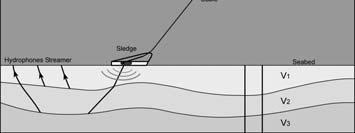
8 Geophysical Survey Basic Principles Use of geophysical remote sensing techniques, calibrated by some limited ground truth sampling. Virtually always use acoustic methods In operation, an acoustic energy source generates a pulse of sound that travels through the water column and, where powerful enough, penetrates into the seabed. The sound energy is reflected back as an echo to a receiver system and the lapse in travel time from transmission to reception is converted into ranges. 15 Geophysical Techniques The sensors tend to fall into three categories: Seabed measuring sensors, e.g. echo sounders, single beam, multi beam sounders (Water depth measurement, seabed topography) Imaging sensors, e.g. side-scan sonar, laser-scan, acoustic scanning systems (for generating a scaled image of the seabed morphology and features, Detection/identification of seabed obstructions) Sub-bottom profilers, e.g. pingers, boomers etc. (Interpretation of soil lithology, stratification, Shallow Gas Detection) 16 8


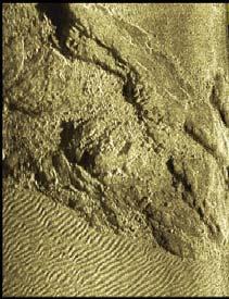

9 Side scan sonar and images


10 GAMBAS operating principles


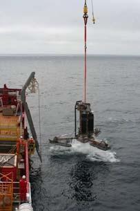
11 Jack-up Rig Foot Prints 21 JUR Imprints 22 11


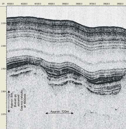
12 Buried Pipelines 23 Pockmarks Acoustic record of pockmarks North Sea Shallow depressions formed in soft clay sediments by escaping gas bubbles. - a long axis of around 57m - with a mean depth of 2m to 8m deep 24 12


13 Autonomous Underwater Vehicles (AUV) AUVs have mission endurance ranging from 12 to 60 or more hours and some can reach depths of 6000 m. 25 HUGIN 3000 (High Precision Untethered Geosurvey and Inspection System) Semi-autonomous vehicle independently powered and controlled (cable free). Depth rated to 3000 metres. Inertial Navigation System Positional accuracy of the AUV is less than 5 m, significantly better than towed systems Sensors Multibeam Bathymetry and Imagery System Chirp Side Scan Sonar Chirp Sub-bottom Profiler Magnetometer (optional) 26 13

14 Gravity Corer Vibro Corer 27 Geotechnical Investigation 28 14
15 Self Elevating Platforms >4.0m & < 20.0m Water Depth Techniques: All onshore drilling, sampling and in-situ testing methods 29 Specialized Geotechnical Investigation Vessels > 20.0m Water depth Techniques: Wire line sampling and insitu testing (CPTU, seismic cone, vane) ONGC GTV- Samudra Sarvekshak 30 15


16 Geotechnical Investigation Inter tidal Zone < 4.0m Water Depth Techniques: All onshore drilling, sampling and in-situ testing methods


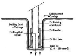
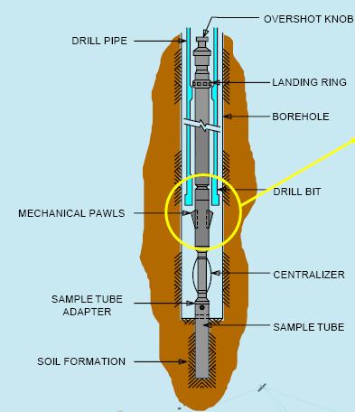
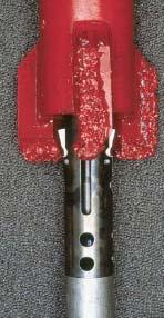
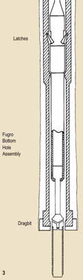
17 DRILLING SYSTEM FOR DOWNHOLE SAMPLING & IN-SITU TESTING Geotechnical Drilling Systems - Drilling Rigs - Reaction Systems - Motion Compensation Systems


18 35 PROD Portable Remotely Operated Drill 2000-m water depths 150-m exploration depths bsf 36 18


19 PROD on deck 37 Launch and recovery 38 19


20 Remotely operated & automated drilling Samples offloaded on deck 39 Scope of a Geotechnical Investigation. One or more soil borings depending on: - Type and size of structure - Soil conditions - Spatial soil variability potential. Supplemented by in-situ testing: - Cone (CPT) soundings - Remove vane tests - Piezo probe tests - Hydraulic fracture tests 40 20


21


22 Sampling and In-Situ Testing Three Approaches:. Down hole mode. Seafloor mode. Over the Side mode Down hole Mode 43 Seabed In Situ Systems Seafloor Mode Deepwater Wheel drive SEACALF 44 22

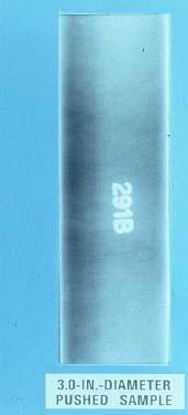
23 45 Push Samples 46 23


24 47 Downhole Vane 48 24

25 WISON Mk-III 49 Downhole Piezo-Cone 50 25


26 Hydraulic Fracture Test 51 Field Laboratory Testing Soil Classification Unit Weight Moisture Content 52 26


27 Field Laboratory Testing Shear Strength Determination Torvane & Pocket Penetrometer tests UU Triaxial Miniature vane test 53 Required Basic Soil and Rock Parameters 54 27
28 Additional Parameters for Specific Design Issues
 Static and Dynamic Lateral Behavior - p-y data 58")
29 Standard Design requirements Axial Pile capacity vs depth of pile penetration Lateral Pile Load-Deflection Data (p-y) Axial Pile Load-Settlement Data (t-z,q-z) Mud-mat Bearing Capacity Pile Driving Recommendations 57 Engineering Analyses Static and Dynamic Axial Behavior - Ultimate Capacity - Load Settlement (t-z, q-z analysis) Static and Dynamic Lateral Behavior - p-y data 58 29
 Pile Driving Analysis Deepwater Anchor Analysis 59 Non-Routine Engineering Analyses Finite Element Studies Conductor Studies - Jetted - Drilled & Grouted - Suction Pile Setup Studies")
30 Additional Engineering Analyses Pile-Spud can Interaction Studies MODU Foundation Stability Assessment Mud-mat Bearing Capacity Pile Monitoring and Drivability Studies Mudflow Studies (Wave induced) Pile Driving Analysis Deepwater Anchor Analysis 59 Non-Routine Engineering Analyses Finite Element Studies Conductor Studies - Jetted - Drilled & Grouted - Suction Pile Setup Studies 60 30
31 A representative schedule for deepwater site investigation 61 Breakdown of project cost 62 31
32 COST One bore hole (Year 2005 ) Mobilization : 600,000 USD Borehole : 130,000 USD Lab testing : 8,000 USD Report : 15,000 USD Total : 753,000 USD Present cost 1.3~2.0 million USD 63 Questions 64 32
33 These presentations are for the purpose of generating awareness in the field of Marine Geotechnology and Foundations for Offshore structures with no commercial intent. Reference: The list below is not exhaustive. API (2000) & Errata & Supplement 1, 2 & 3 (2002, 2005 & 2007) Recommended Practice for Planning, Designing and Constructing Fixed Offshore Platforms Working Stress Design, API RP 2A, American Petroleum Institute, Washington, USA. API (2005) Recommended Practice for Design and Analysis of Station Keeping Systems for Floating Structures, API RP 2SK, American Petroleum Institute, Washington, USA. API (2011) Geotechnical and Foundation Design Considerations, API GEO, American Petroleum Institute, Washington, USA. Herbich, J.B (1991) Handbook of Coastal and Ocean Engineering, Gulf Publishing Co. McCarron, W.O. (2011) Deepwater Foundations and Pipeline Geomechanics, Joss Publishing. OTC (1969 to 2013) Proceedings Annual Offshore Technology Conference, OTC Volumes, Houston Texas, USA Le Tirant, P. (1979) Seabed Reconnaissance and Offshore Soil Mechanics for the Installation of Petroleum Structures, Ed. Technip, Paris Poulos, H.G. (1988) Marine Geotechnics. Unwin Hyman, London. Rendolph, M. & Gourvenec, S. Offshore Geotechnical Engineering, Spon Press, New York, USA. Part-I Foundation Concepts 65 Various Internet Sites: Part-I Foundation Concepts 66 33

34 Thank you for your attention 67 34
Geophysical Site Surveys
 Geophysical Site Surveys Simon Oakley Geoscience Team Leader Fugro Survey Limited 16/04/2014 Contents Menu Introduction Section 1 - Geophysical Site Surveys - Seabed Bathymetry - Shallow Geology - Seabed
Prof. Dr.-Ing. Martin Achmus Institute of Soil Mechanics, Foundation Engineering and Waterpower Engineering. Offshore subsoil investigations
 Prof. Dr.-Ing. Martin Achmus Institute of Soil Mechanics, Foundation Engineering and Waterpower Engineering Offshore subsoil investigations Addis Ababa, September 2010 Offshore subsoil investigations Presentation
Offshore Operations and Project Execution Geophysical Site Surveys
 Offshore Operations and Project Execution Geophysical Site Surveys Chris Almond Senior Geophysicist Fugro Survey Limited 22/04/2015 Presentation Summary: Office-based Personnel Project Awarded Pre Offshore
BAUER MeBo Sea Bed Drill Rig
 BAUER MeBo Sea Bed Drill Rig Spotlights BAUER Maritime Experiences 1993 Diamond deposit exploration with a BC cutter in water depth of 160 m (South Africa) Atlantic Ocean 2005 Drilling inside of a monopile
(32) marine technology April
 marine technology April") As part of a 2012 Gulf of Mexico deep water project, an Echoscope 3D sonar imager documented the depth of a 20 pipeline in a trench, below mud line, during a post-dredging operation. (32) marine technology
As part of a 2012 Gulf of Mexico deep water project, an Echoscope 3D sonar imager documented the depth of a 20 pipeline in a trench, below mud line, during a post-dredging operation. (32) marine technology
Seabed instability and 3D FE jack-up soil-structure interaction analysis
 Seabed instability and 3D FE jack-up soil-structure interaction analysis Lindita Kellezi, GEO Danish Geotechnical Institute, Denmark Gregers Kudsk, Maersk Contractors, Denmark Hugo Hofstede, Marine Structure
Data and Information Management. UK All Energy 22 nd May Presented by Leo James
 Data and Information Management UK All Energy 22 nd May 2013 Presented by Leo James Strategic Development Plans Observations at the outset Data and information management and dissemination: company or
OFFSHORE SURVEY IN THE OIL & GAS INDUSTRY WHAT S THAT ALL ABOUT? Ian Douglas Head, Offshore Surveys, Shell Projects & Technology Europe
 OFFSHORE SURVEY IN THE OIL & GAS INDUSTRY WHAT S THAT ALL ABOUT? Ian Douglas Head, Offshore Surveys, Shell Projects & Technology Europe Hydrofest 2014 13 March 2014 1 Why Position Matters The Exploration
Hydrofest The Hydrographic Society in Scotland
 Hydrofest 2017 The Hydrographic Society in Scotland Offshore Survey in the Oil and Gas Industry Hydrofest 2017 Chris Leaf Head Offshore Surveys Shell Projects and Technology, Europe Presentation Overview
KDOT Geotechnical Manual Edition. Table of Contents
 KDOT Geotechnical Manual 2007 Edition The KDOT Geotechnical Manual is available two volumes. Both volumes are very large electronic (pdf) files which may take several minutes to download. The table of
NEW SEAFLOOR INSTALLATIONS REQUIRE ULTRA-HIGH RESOLUTION SURVEYS
 NEW SEAFLOOR INSTALLATIONS REQUIRE ULTRA-HIGH RESOLUTION SURVEYS Donald Hussong (Fugro Seafloor Surveys, Inc.) dhussong@fugro.com Fugro Seafloor Surveys, Inc., 1100 Dexter Avenue North (Suite 100), Seattle,
Cone Penetration Testing in Geotechnical Practice
 Cone Penetration Testing in Geotechnical Practice Table Of Contents: LIST OF CONTENTS v (4) PREFACE ix (2) ACKNOWLEDGEMENTS xi (1) SYMBOL LIST xii (4) CONVERSION FACTORS xvi (6) GLOSSARY xxii 1. INTRODUCTION
ENCE 3610 Soil Mechanics. Site Exploration and Characterisation Field Exploration Methods
 ENCE 3610 Soil Mechanics Site Exploration and Characterisation Field Exploration Methods Geotechnical Involvement in Project Phases Planning Design Alternatives Preparation of Detailed Plans Final Design
Introduction to Acoustic Remote Sensing and Seafloor Mapping (AE4-E13) May 19, 2010
 May 19, 2010") Introduction to Acoustic Remote Sensing and Seafloor Mapping (AE4-E13) May 19, 2010 1 Delft Vermelding Institute onderdeel of Earth organisatie Observation and Space Systems Why Acoustic Remote Sensing?
Introduction to Acoustic Remote Sensing and Seafloor Mapping (AE4-E13) May 19, 2010 1 Delft Vermelding Institute onderdeel of Earth organisatie Observation and Space Systems Why Acoustic Remote Sensing?
Site Investigations for Offshore Wind
 Site Investigations for Offshore Wind A multi-disciplinary approach Mattijs de Lange Gardline Marine Sciences Limited My thanks to: Maarten Timmerman David Cerda Saltzman Sue Crothers Albert van der Hem
Chapter 12 Subsurface Exploration
 Page 12 1 Chapter 12 Subsurface Exploration 1. The process of identifying the layers of deposits that underlie a proposed structure and their physical characteristics is generally referred to as (a) subsurface
SITE INVESTIGATION 1
 SITE INVESTIGATION 1 Definition The process of determining the layers of natural soil deposits that will underlie a proposed structure and their physical properties is generally referred to as site investigation.
Marine Geophysical Methods: What Can and Cannot Be Done to Iden8fy Hazards to Dredging & Marine Construc8on
 Marine Geophysical Methods: What Can and Cannot Be Done to Iden8fy Hazards to Dredging & Marine Construc8on Marine Geophysics Sham or Savior? Seen alternatively as the silver bullet or snake oil, marine
ADDENDUM 1. Page 1, 1 Scope, replace the final bullet, and insert an additional bullet as follows:
 Date of Issue: October 2014 Affected Publication: API Recommended Practice 2GEO/ISO 19901-4, Geotechnical and Foundation Design Considerations, 1 st Edition, April 2011 ADDENDUM 1 Page 1, 1 Scope, replace
ENERGIES MARINES RENOUVELABLES: Géotechnique & Fondations Hong DOAN & Denys BOREL. Rencontre des partenaires WeAMEC du 7 avril 2017
 ENERGIES MARINES RENOUVELABLES: Géotechnique & Fondations Hong DOAN & Denys BOREL Rencontre des partenaires WeAMEC du 7 avril 2017 Ground model - Making the Development Site Transparent Starting Point
Underground Risk Management Course Marina Del Rey, California November, Geotechnical Data Reports. Greg Raines, PE
 Underground Risk Management Course Marina Del Rey, California November, 2018 Geotechnical Data Reports Greg Raines, PE Gregory.Raines@Stantec.com Introduction What is a Geotechnical Data Report? The GDR
Guidelines for the conduct of offshore drilling hazard site surveys
 Guidelines for the conduct of offshore drilling hazard site surveys Report No. 373-18-1 April 2011 International Association of Oil & Gas Producers P ublications Global experience The International Association
Department of National Defence B-Jetty Reconstruction
 Department of National Defence B-Jetty Reconstruction CFB Esquimalt, BC Presented by: Stantec & Golder Associates February 2, 2016 Agenda 1 B-Jetty Project Background 2 Distinguishing Project Features
Marine Heat Flow Measurements Information Brochure
 Marine Heat Flow Measurements Information Brochure 5 1 2 3 4 5 5 6 7 8 5 9 10 11 12 13 14 5 15 16 17 18 19 20 21 5 22 0 200 400 600 800 1000 1200 1400 1600 Time (s) What is the use of heat flow measurements?
3. EVOLUTION In 1948 the basic mechanical cone was developed (Figure 1) and this cone is still in use today as the
 and this cone is still in use today as the") 1. WHAT IS CPT? A CPT is carried out by pushing a calibrated cone vertically into the ground and measuring the forces applied on its conical tip, the friction on the sides of the cone and, if using a piezocone,
1. WHAT IS CPT? A CPT is carried out by pushing a calibrated cone vertically into the ground and measuring the forces applied on its conical tip, the friction on the sides of the cone and, if using a piezocone,
(C) Global Journal of Engineering Science and Research Management
 Global Journal of Engineering Science and Research Management") GEOTECHNCIAL ASSESSMENT OF PART OF PORT HARCOURT, NIGER DELTA FOR STRUCTURAL ANALYSIS Warmate Tamunonengiyeofori Geostrat International Services Limited, www.geostratinternational.com. *Correspondence
GEOTECHNCIAL ASSESSMENT OF PART OF PORT HARCOURT, NIGER DELTA FOR STRUCTURAL ANALYSIS Warmate Tamunonengiyeofori Geostrat International Services Limited, www.geostratinternational.com. *Correspondence
Exploitation of Ocean Predictions by the Oil and Gas Industry. GODAE OceanView Symposium 2013
 Exploitation of Ocean Predictions by the Oil and Gas Industry GODAE OceanView Symposium 2013 Introduction Information needs Challenges Acknowledgements IMarEST/SUT Metocean Awareness Course Colleagues
ON BOARD GEOTECHNICAL REPORT
 ON BOARD GEOTECHNICAL REPORT ON GEOTECHNICAL INVESTIGATION AND FOUNDATION ASSESSMENT OF JACKUP RIGS AT: GK-28-D, KACHCHH FIELD LOCATION WEST COAST, OFFSHORE INDIA. SUBMITTED TO ONGC MARINE SURVEY DIVISION
The Arctic - A New Frontier The geological, environmental and engineering challenges for submarine telecommunication cables
 The Arctic - A New Frontier The geological, environmental and engineering challenges for submarine telecommunication cables Ryan Wopschall 5 September 2013 Oceanology International China, Shanghai Fugro
OTC Copyright 2008, Offshore Technology Conference
 OTC 19580 Detailed Geotechnical Investigation Around In-Place Mat Foundation Including T-Bar and Cpt Comparisons Jean M.E. Audibert, Quest Geo-Technics, Steve Neubecker, Advanced Geomechanics and Stewart,
Manual on Subsurface Investigations National Highway Institute Publication No. FHWA NHI Federal Highway Administration Washington, DC
 Manual on Subsurface Investigations National Highway Institute Publication No. FHWA NHI-01-031 Federal Highway Administration Washington, DC Geotechnical Site Characterization July 2001 by Paul W. Mayne,
THE 4Gs IN PRACTICE: INVESTIGATING HOW THE 4Gs ARE APPLIED IN THE OIL & GAS INDUSTRY
 THE 4Gs IN PRACTICE: INVESTIGATING HOW THE 4Gs ARE APPLIED IN THE OIL & GAS INDUSTRY Society for Underwater Technology, Evening Technical Meeting 14 AUGUST 2013 GEOPHYSICS & PORT DEVELOPMENTS EXPLORING
Automated Seabed Mapping and Data Delivery in the Cloud
 Automated Seabed Mapping and Data Delivery in the Cloud London, 2nd November 2017 11/20/2017 1 2 WE CALL IT SEABED INTELLIGENCE Ocean Infinity are explorers. We go to unmapped locations to survey the seabed
DESIGN AND INSTALLATION OF DYNAMICALLY INSTALLED PILES
 Guidance Notes on Design and Installation of Dynamically Installed Piles GUIDANCE NOTES ON DESIGN AND INSTALLATION OF DYNAMICALLY INSTALLED PILES DECEMBER 017 (Updated March 018 see next page) American
The process of determining the layers of natural soil deposits that will underlie a proposed structure and their physical properties is generally
 The process of determining the layers of natural soil deposits that will underlie a proposed structure and their physical properties is generally referred to as sub surface investigation 2 1 For proper
TABLE OF CONTENTS CHAPTER TITLE PAGE TITLE PAGE DECLARATION DEDIDATION ACKNOWLEDGEMENTS ABSTRACT ABSTRAK
 TABLE OF CONTENTS CHAPTER TITLE PAGE TITLE PAGE DECLARATION DEDIDATION ACKNOWLEDGEMENTS ABSTRACT ABSTRAK TABLE OF CONTENTS LIST OF TABLE LIST OF FIGURES LIST OF SYMBOLS LIST OF APENDICES i ii iii iv v
IAEA SAFETY STANDARDS Geotechnical Aspects of Site Evaluation and Foundations in NPPs, NS-G-3.6
 IAEA SAFETY STANDARDS Geotechnical Aspects of Site Evaluation and Foundations in NPPs, NS-G-3.6 Regional Workshop on Volcanic, Seismic, and Tsunami Hazard Assessment Related to NPP Siting Activities and
Instructional Objectives
 GE 6477 DISCONTINUOUS ROCK 8. Fracture Detection Dr. Norbert H. Maerz Missouri University of Science and Technology (573) 341-6714 norbert@mst.edu Instructional Objectives 1. List the advantages and disadvantages
ISO INTERNATIONAL STANDARD
 INTERNATIONAL STANDARD ISO 19901-4 First edition 2003-08-01 Petroleum and natural gas industries Specific requirements for offshore structures Part 4: Geotechnical and foundation design considerations
SASKATCHEWAN STRATIGRAPHY GLACIAL EXAMPLE BOULDERS IN GLACIAL DEPOSITS
 SASKATCHEWAN STRATIGRAPHY GLACIAL EXAMPLE BOULDERS IN GLACIAL DEPOSITS 51 SASKATCHEWAN STRATIGRAPHY GLACIAL SURFICIAL STRATIFIED DEPOSITS 52 SASKATCHEWAN STRATIGRAPHY GLACIAL EXAMPLE OF SEDIMENT DEPOSITION
Geophysical Site Investigation (Seismic methods) Amit Prashant Indian Institute of Technology Gandhinagar
 Amit Prashant Indian Institute of Technology Gandhinagar") Geophysical Site Investigation (Seismic methods) Amit Prashant Indian Institute of Technology Gandhinagar Short Course on Geotechnical Aspects of Earthquake Engineering 04 08 March, 2013 Seismic Waves
Geophysical Site Investigation (Seismic methods) Amit Prashant Indian Institute of Technology Gandhinagar Short Course on Geotechnical Aspects of Earthquake Engineering 04 08 March, 2013 Seismic Waves
SI Planning & Laboratory Testing for Hill-Site Development
 SI Planning & Laboratory Testing for Hill-Site Development 21 April 2009 IEM Penang Ir. Tan Yean Chin G&P Geotechnics Sdn Bhd Cameron Highlands, 1961 Genting Highland Tower 1993 Bukit Antarabangsa, 1999
Engineering in Support of Transformative Science
 Engineering in Support of Transformative Science Scientific Ocean Drilling of Mid-Ocean Ridge and Ridge-Flank Setting Workshop August 27, 2009 Austin, Texas Greg Myers IODP-MI Outline o Main engineering
SP-2209-OCN Handbook for Marine Geotechnical Engineering
 ENGINEERING SERVICE CENTER Port Hueneme, California 93043-4370 SP-2209-OCN Handbook for Marine Geotechnical Engineering Technical Editors: David Thompson Diane Jarrah Beasley February 2012 Approved for
Week 3 : (3HL) Coverage : Typical geotechnical problems and usual application of SI methods
 Coverage : Typical geotechnical problems and usual application of SI methods") LEARNING OUTCOMES Week 3 : (3HL) Coverage : Typical geotechnical problems and usual application of SI methods Learning Outcomes : At the end of this lecture/week, the students will be able to : 1. Discuss
LEARNING OUTCOMES Week 3 : (3HL) Coverage : Typical geotechnical problems and usual application of SI methods Learning Outcomes : At the end of this lecture/week, the students will be able to : 1. Discuss
Kyle Griebel NRS 509 Dr. August & Dr. Wang GIS and remote sensing in Seafloor mapping
 GIS and remote sensing in Seafloor mapping Introduction to seafloor mapping Seafloor maps have a wide variety of uses for scientists and coastal planning needs. Some of these uses include biological assessment
10. GEOTECHNICAL EXPLORATION PROGRAM
 Geotechnical site investigations should be conducted in multiple phases to obtain data for use during the planning and design of the tunnel system. Geotechnical investigations typically are performed in
FINMARINET: Inventories and Planning for the Marine Natura 2000 Network in Finland. A.2 Geological inventories of the seafloor Final Report
 LIFE07 NAT/FIN/000151 FINMARINET: Inventories and Planning for the Marine Natura 2000 Network in Finland A.2 Geological inventories of the seafloor Final Report Geological Survey of Finland, GTK 1. Introduction
Multibeam Hydrographic Survey Use for Construction Control of Filling and Ground Improvement Activities
 Multibeam Hydrographic Survey Use for Construction Control of Filling and Ground Improvement Activities WEDA Cincinnati April 10, 2014 Ray Wood C.Eng Executive Vice President Fugro Consultants Inc Advantages
Site Investigations and Geotechnical Risk For Underground Construction Greg Raines, PE
 August 14, 2017 Site Investigations and Geotechnical Risk For Underground Construction Greg Raines, PE Gregory.Raines@Stantec.com Develop Preliminary Geologic / Geotech Conceptual Model for the Project
Coring and sediment sampling
 Coring and sampling Principle: In order to ground-truth geophysical data, it is necessary to obtain a sample of the seabed. There are two main techniques available for sampling unconsolidated s : (1) seabed
GG710 Remote Sensing in Submarine Environments Sidescan Sonar
 GG710 Remote Sensing in Submarine Environments Sidescan Sonar Harold Edgerton, a professor of electrical engineering at the Massachusetts Institute of Technology, developed sidescan sonar technology for
Acoustic seafloor mapping systems. September 14, 2010
 Acoustic seafloor mapping systems September 14, 010 1 Delft Vermelding Institute onderdeel of Earth organisatie Observation and Space Systems Acoustic seafloor mapping techniques Single-beam echosounder
Appendix 3: Sæby Offshore Wind Farm Technical Description, Offshore
 Appendix 3: Sæby Offshore Wind Farm Technical Description, Offshore Appendix 3: Sæby Offshore Wind Farm Technical Description, Offshore Appendix 3: Sæby Offshore Wind Farm Technical Description, Offshore
GUIDANCE NOTES ON GEOTECHNICAL INVESTIGATIONS FOR MARINE PIPELINES
 FOR MARINE PIPELINES PAGE 1 OF 47 GUIDANCE NOTES ON GEOTECHNICAL INVESTIGATIONS FOR MARINE PIPELINES Issue: OSIG Rev 03 Status: Final for Issue Date: 17/09/04 Prepared by the Pipeline Working Group of
INTRODUCTION TO STATIC ANALYSIS PDPI 2013
 INTRODUCTION TO STATIC ANALYSIS PDPI 2013 What is Pile Capacity? When we load a pile until IT Fails what is IT Strength Considerations Two Failure Modes 1. Pile structural failure controlled by allowable
Platforms for Shallow Water Drilling. Gregory Mountain and Neal Driscoll. JOIDES Journal, 1997 Vol.23(2):15-17
:15-17") Platforms for Shallow Water Drilling Gregory Mountain and Neal Driscoll JOIDES Journal, 1997 Vol.23(2):15-17 Additional platforms for shallow water drilling that complement the strengths and capabilities
Platforms for Shallow Water Drilling Gregory Mountain and Neal Driscoll JOIDES Journal, 1997 Vol.23(2):15-17 Additional platforms for shallow water drilling that complement the strengths and capabilities
Boreholes. Implementation. Boring. Boreholes may be excavated by one of these methods: 1. Auger Boring 2. Wash Boring 3.
 Implementation Boreholes 1. Auger Boring 2. Wash Boring 3. Rotary Drilling Boring Boreholes may be excavated by one of these methods: 4. Percussion Drilling The right choice of method depends on: Ground
BELFAST SEWERS PROJECT
 BELFAST SEWERS PROJECT Adam Green - Atkins Tunnelling Scheme Overview New stormwater interceptor Tunnel Scheme within Belfast City Centre to alleviate flooding and divert storm water flows from existing
Estimation of Pore Pressure from Well logs: A theoretical analysis and Case Study from an Offshore Basin, North Sea
 P-217 Estimation of Pore Pressure from Well logs: A theoretical analysis and Case Study from an Offshore Basin, North Sea Pritam Bera Final Year, M.Sc.Tech. (Applied Geophysics) Summary This paper concerns
 www.novotechsoftware.com The standard penetration test (SPT) is an in-situ dynamic penetration test designed to provide information on the geotechnical engineering properties of soil. The test procedure
CHARACTERIZATION OF SOFT CLAY- A CASE STUDY AT CRANEY ISLAND
 National Defense Industrial Association 2005 Tri-Service Infrastructure Systems Conference and Exhibition Re-Energizing Engineering Excellence CHARACTERIZATION OF SOFT CLAY- A CASE STUDY AT CRANEY ISLAND
IN SITU TESTING IN GEOMECHANICS. Fernando Schnaid Universidade Federal do Rio Grande do Sul
 IN SITU TESTING IN GEOMECHANICS Fernando Schnaid Universidade Federal do Rio Grande do Sul Patologia das Fundações Geotechnical investigation British Practice (Weltman & Head,1981): Sufficient finance
ABSTRACT. Use and Application of Piezocone Penetration Testing in Presumpscot Formation
 ABSTRACT Use and Application of Piezocone Penetration Testing in Presumpscot Formation Presumpscot Formation is commonly referred to as glacial marine clay found along the coastline of eastern New England.
SCOPE OF INVESTIGATION Simple visual examination of soil at the surface or from shallow test pits. Detailed study of soil and groundwater to a
 Lecture-5 Soil Exploration Dr. Attaullah Shah 1 Today s Lecture Purpose of Soil Exploration Different methods 1. Test trenches and Pits 2. Auger and Wash Boring 3. Rotary Drilling 4. Geophysical Methods
IGC. 50 th INDIAN GEOTECHNICAL CONFERENCE ESTIMATION OF FINES CONTENT FROM CPT PARAMETERS FOR CALCAREOUS SOILS OF WESTERN INDIAN OFFSHORE
 5 th 5 th INDIAN GEOTECHNICAL CONFERENCE 17 th 19 th DECEMBER 215, Pune, Maharashtra, India ESTIMATION OF FINES CONTENT FROM CPT PARAMETERS FOR CALCAREOUS SOILS OF WESTERN INDIAN OFFSHORE Alankar Srivastava
Gotechnical Investigations and Sampling
 Gotechnical Investigations and Sampling Amit Prashant Indian Institute of Technology Gandhinagar Short Course on Geotechnical Investigations for Structural Engineering 12 14 October, 2017 1 Purpose of
GEOTECHNICAL ENGINEERING II. Subject Code : 06CV64 Internal Assessment Marks : 25 PART A UNIT 1
 GEOTECHNICAL ENGINEERING II Subject Code : 06CV64 Internal Assessment Marks : 25 PART A UNIT 1 1. SUBSURFACE EXPLORATION 1.1 Importance, Exploration Program 1.2 Methods of exploration, Boring, Sounding
Lesson 25. Static Pile Load Testing, O-cell, and Statnamic. Reference Manual Chapter 18
 Lesson 25 Static Pile Load Testing, O-cell, and Statnamic Reference Manual Chapter 18 STATIC LOAD TESTING Most accurate method to determine static pile capacity Perform at design or construction stage
IOGP Hazard Survey Guidelines and Technical Notes. Andy W Hill, BP America, March 2016
 IOGP Hazard Survey Guidelines and Technical Notes Andy W Hill, BP America, March 2016 Summary Background to the IOGP Guidelines for the Conduct of Offshore Drilling Hazard Site Surveys (DHSS) Objective
12/11/2013& egm502 seafloor mapping
 egm502 seafloor mapping lecture 13 multi-beam echo-sounders The majority of the current charts of the ocean floors have been produced from single beam echo-sounder data. Even though these data have been
Engineer. Engineering. Engineering. (in-ja-neer ) A person trained and skilled in any of the various branches of engineering: a civil engineer
 A person trained and skilled in any of the various branches of engineering: a civil engineer") Engineer (in-ja-neer ) A person trained and skilled in any of the various branches of engineering: a civil engineer (Random House Webster s College Dictionary, 1991) CE100 Introduction to Civil Geotechnical
Engineer (in-ja-neer ) A person trained and skilled in any of the various branches of engineering: a civil engineer (Random House Webster s College Dictionary, 1991) CE100 Introduction to Civil Geotechnical
IN SITU TESTING TECHNOLOGY FOR FOUNDATION & EARTHQUAKE ENGINEERING. Wesley Spang, Ph.D., P.E. AGRA Earth & Environmental, Inc.
 IN SITU TESTING TECHNOLOGY FOR FOUNDATION & EARTHQUAKE ENGINEERING Wesley Spang, Ph.D., P.E. AGRA Earth & Environmental, Inc. Portland, Oregon In situ testing of soil, which essentially consists of evaluating
GEOTECHNICAL ENGINEERING INVESTIGATION HANDBOOK Second Edition
 GEOTECHNICAL ENGINEERING INVESTIGATION HANDBOOK Second Edition Roy E. Hunt Taylor & Francis Taylor & Francis Croup Boca Raton London New York Singapore A CRC title, part of the Taylor & Francis imprint,
Exploration, Drilling & Production
 Nontechnical Guide to PETMOLEUM Geology, Exploration, Drilling & Production Third Edition Norman J. Hyne, Ph.D. Contents Preface *i Introduction 1 The Nature of Gas and Oil 1 Petroleum 1 The Chemistry
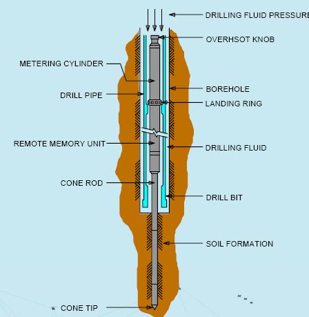
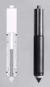
NEW DOWN-HOLE PENETROMETER (DHP-CIGMAT) FOR CONSTRUCTION APPLICATIONS
 FOR CONSTRUCTION APPLICATIONS") NEW DOWN-HOLE PENETROMETER (DHP-CIGMAT) FOR CONSTRUCTION APPLICATIONS 1 2 C. Vipulanandan 1, Ph.D., M. ASCE and Omer F. Usluogullari 2 Chairman, Professor, Director of Center for Innovative Grouting Materials
NEW DOWN-HOLE PENETROMETER (DHP-CIGMAT) FOR CONSTRUCTION APPLICATIONS 1 2 C. Vipulanandan 1, Ph.D., M. ASCE and Omer F. Usluogullari 2 Chairman, Professor, Director of Center for Innovative Grouting Materials
VMS-GeoMil. Background
 Background When using a drilling rig for cone penetration testing, a mechanical clamp can be mounted to the drilling head (by means of a special transition piece). The depth than can be achieved depends
National Marine Sanctuary Program
 National Marine Sanctuary Program NMSP/USGS Joint Seabed Mapping Initiative: September 2004 AA National Ocean Service National Marine Sanctuaries Interim Report September 2004 Background: Since 2002,
Role of the Geotechnical Consultant in Design Build Projects a General Contractors Geotechnical Engineer s Perspective
 Role of the Geotechnical Consultant in Design Build Projects a General Contractors Geotechnical Engineer s Perspective Steven R. Saye Kiewit Engineering Group, Inc. Design Build Geotechnical Goal All parties
The Seafloor deformation and well bore stability monitoring during gas production in unconsolidated reservoirs
 The Seafloor deformation and well bore stability monitoring during gas production in unconsolidated reservoirs *Joo Yong Lee, Jong-Hwa Chun and Se Joon Kim Petroleum & Marine Research Division, KIGAM,
 UNIT I SITE INVESTIGATION AND SELECTION OF FOUNDATION Types of boring 1.Displacement borings It is combined method of sampling & boring operation. Closed bottom sampler, slit cup, or piston type is forced
Lecture 7. Pile Analysis
 Lecture 7 14.5 Release Pile Analysis 2012 ANSYS, Inc. February 9, 2013 1 Release 14.5 Pile definition in Mechanical - There are a number of methods that can be used to analyze piled foundations in ANSYS
Conventional Field Testing & Issues (SPT, CPT, DCPT, Geophysical methods)
") Conventional Field Testing & Issues (SPT, CPT, DCPT, Geophysical methods) Ajanta Sachan Assistant Professor Civil Engineering IIT Gandhinagar Conventional Field Testing 1 Field Test: In-situ shear strength
Conventional Field Testing & Issues (SPT, CPT, DCPT, Geophysical methods) Ajanta Sachan Assistant Professor Civil Engineering IIT Gandhinagar Conventional Field Testing 1 Field Test: In-situ shear strength
Ship heave effects while drilling: observations from Legs 185 & 188
 Ship heave effects while drilling: observations from Legs 185 & 188 D. Goldberg 1, G. Myers 1, G. Guerin 1, D. Schroeder 2 and the Legs 185 & 188 scientific parties 1 Lamont-Doherty Earth Observatory,
Engineering Geophysical Application to Mine Subsidence Risk Assessment
 Engineering Geophysical Application to Mine Subsidence Risk Assessment By: Kanaan Hanna, Sr. Mining Engineer Steve Hodges, Sr. Geophysicist Jim Pfeiffer, Sr. Geophysicist Dr. Keith Heasley, Professor West
Topic: Bathymetric Survey Techniques. (a) Single-beam echo-sounders (SBES) (b) Multi-beam echo-sounders (MBES)
 Single-beam echo-sounders (SBES) (b) Multi-beam echo-sounders (MBES)") Topic: Bathymetric Survey Techniques (a) Single-beam echo-sounders (SBES) (b) Multi-beam echo-sounders (MBES) Bathymetry is the measurement of water depths - bathymetry is the underwater equivalent of
Topic: Bathymetric Survey Techniques (a) Single-beam echo-sounders (SBES) (b) Multi-beam echo-sounders (MBES) Bathymetry is the measurement of water depths - bathymetry is the underwater equivalent of
Regional Workshop on Essential Knowledge of Site Evaluation Report for Nuclear Power Plants. IAEA Safety Guide on Geotechnical Aspects, NS-G-3.
 Regional Workshop on Essential Knowledge of Site Evaluation Report for Nuclear Power Plants Kuala Lumpur, Malaysia, 26-30 August 2013 IAEA Safety Guide on Geotechnical Aspects, NS-G-3.6 Hamid Mahmood International
Rock Berm Restraint of an Untrenched Pipeline on Soft Clay
 Rock Berm Restraint of an Untrenched Pipeline on Soft Clay J.-C. Ballard, P.H. Yonatan and M.J. Rattley, Fugro GeoConsulting A. Griffiths, Shell UK Limited ABSTRACT This paper discusses soil structure
WORK PLAN SEDIMENT, SURFACE WATER, AND GROUNDWATER SAMPLING PLAN TO ASSESS CURRENT GROUNDWATER DISCHARGE IMPACTS TO THE OFFSHORE ENVIRONMENT
 WORK PLAN SEDIMENT, SURFACE WATER, AND GROUNDWATER SAMPLING PLAN TO ASSESS CURRENT GROUNDWATER DISCHARGE IMPACTS TO THE OFFSHORE ENVIRONMENT Prepared for Severstal-Sparrows Point, LLC 1430 Sparrows Point
MEDAT-2: Some Geotechnical Opportunities. Site Characterization -- Opportunities. Down-hole CPT & vane (Fugro)
") MEDAT-2: Some Geotechnical Opportunities Ross W. Boulanger Department of Civil & Environmental Engineering University of California Davis, California 95616-5294 rwboulanger@ucdavis.edu Presentation for
MEDAT-2: Some Geotechnical Opportunities Ross W. Boulanger Department of Civil & Environmental Engineering University of California Davis, California 95616-5294 rwboulanger@ucdavis.edu Presentation for
Importance of CPT in development of offshore windfarms
 Importance of CPT in development of offshore windfarms Tom Lunne, NGI Outline Background Overview of potential foundation types, forces and special challenges Range of soils typically encountered Soil
Cavity Expansion Methods in Geomechanics
 Cavity Expansion Methods in Geomechanics by Hai-Sui Yu School of Civil Engineering, University of Nottingham, U. K. KLUWER ACADEMIC PUBLISHERS DORDRECHT / BOSTON / LONDON TABLE OF CONTENTS Foreword Preface
Themes for Geomatics Conference. Geodesy Themes
 Themes for Geomatics Conference Geodesy Themes Geodynamics o Modeling the Deformation of the Earth s Crust o Recent Advances in Geometric Approaches to Deformation Analysis o Monitoring Systems (Sensors
COBRA Cable Site Investigation in the Wadden Sea, Denmark
 NGM 2016 Reykjavik Proceedings of the 17 th Nordic Geotechnical Meeting Challenges in Nordic Geotechnic 25 th 28 th of May COBRA Cable Site Investigation in the Wadden Sea, Denmark L. Klinkby COWI, Denmark,
Effect of the Spudcan s Footprints on Nearby Jacket s Mudmat in Clayey Soil-Case Study
 INTERNATIONAL JOURNAL OF MARITIME TECHNOLOGY IJMT Vol.6/ Summer 2016 (41-50) Available online at: http://ijmt.ir/browse.php?a_code=a-10-700-1&sid=1&slc_lang=en Effect of the Spudcan s Footprints on Nearby
Geophysics for Environmental and Geotechnical Applications
 Geophysics for Environmental and Geotechnical Applications Dr. Katherine Grote University of Wisconsin Eau Claire Why Use Geophysics? Improve the quality of site characterization (higher resolution and
Sea floor stability offshore Lofoten, Northern Norway (LOSLOPE) A PETROMAKS FP by the University of Tromsø (UiT)
 A PETROMAKS FP by the University of Tromsø (UiT)") Sea floor stability offshore Lofoten, Northern Norway (LOSLOPE) A PETROMAKS FP by the University of Tromsø (UiT) Main objective The main objective of this research project is to evaluate the present-day
Sea floor stability offshore Lofoten, Northern Norway (LOSLOPE) A PETROMAKS FP by the University of Tromsø (UiT) Main objective The main objective of this research project is to evaluate the present-day
A lithological map created from multibeam backscatter data in challenging circumstances: the Lower Sea Scheldt estuary
 A lithological map created from multibeam backscatter data in challenging circumstances: the Lower Sea Scheldt estuary Mieke Mathys*, Marc Sas*, Frederik Roose** HYDRO12, Rotterdam, 15/11/2012 *International
Introduction / General Aspects of Marine Sonar and Seismic Surveys. Mustafa Ergün
 Introduction / General Aspects of Marine Sonar and Seismic Surveys Mustafa Ergün INTRODUCTION TO MARINE STUDIES Exploration of the oceans using the techniques of the marine sonar and seismics has had a
A New Generation Seafloor Drill UNICORN-1
 A New Generation Seafloor Drill UNICORN-1 Koji Ochi Fukada Salvage and Marine Works Co., Ltd. Tatsumi Bldg. 3-8-7 Iidabashi, Chiyoda-ku, Tokyo 102-0072 Japan Eric Jackson Cellula Robotics Ltd. B109-9000