Site Investigations for Offshore Wind
|
|
|
- Anis Blair
- 6 years ago
- Views:
Transcription
1 Site Investigations for Offshore Wind A multi-disciplinary approach Mattijs de Lange Gardline Marine Sciences Limited My thanks to: Maarten Timmerman David Cerda Saltzman Sue Crothers Albert van der Hem Cliff Whatrup 1

2 Choose a Location Consents and Permitting considerations 2


3 Design your layout Turbine locations will be defined by: Wind directions/yield Water Depth Geology Shipping Lanes Access to Shore Bird Migration Paths Etc. Turbine Design considerations rotor hub nacelle RNA blade tower platform ladder boat landing transition piece support structure offshore wind turbine power J-tube scour protection mudline cable scour hole foundation pile 3
4 Forces on Foundations air wind waves & current sea soil Preliminary Site Assessment Review existing data and undertake a desk study. Consider Pre-Existing Geological data and key geological processes Preliminary met ocean conditions Identify geotechnical risks Identify areas of insufficient information Outline scope of survey 4


5 Preliminary Site Assessment Preliminary Site Assessment 5


6 Preliminary Site Assessment Preliminary Site Assessment 6
7 A Cautionary Note No recognised guidelines on survey practice for wind farms similar to those outlined for oil and gas by UKOOA An up to date replacement for SUT s OSIG 2005 guidance notes on Site Investigation for Offshore Renewable Energy Projects not yet published Client knowledge based upon previous experience in the design of offshore wind-farms has been very limited due to inexperience and lack of engagement with Oil & Gas sector. There is always a need to minimise survey costs. Funding to do a proper job of the survey only approved after completion of a formal acceptance of an Environmental Impact Assessment. but survey work is required for a comprehensive EIA archaeology, UXO and habitat assessments Site Investigations Need to ensure full swathe bathymetry t and sonar coverage over survey area Ensure sub-bottom profiler data below all probable turbine locations (piling locations), to anticipated pile depth Probable need to see below the multiple in shallow water, and map the refusal surface for foundation design. (Consider the use of multi-channel techniques) Detailed shallow penetration geophysics for cable routes and jack-up leg penetration Different tasks have different requirements: 7


8 Consider what you need from your data and / or Survey Scope Phase 1 - Geophysics Decide on the need for a reconnaissance or detailed IHO Order 1survey over the whole site Establish bathymetry using swathe systems Indentify and locate seabed hazards Determine geometry of subsurface layers Develop your scope for detailed survey or subsequent geotechnical investigations 8


9 The Right Survey Vessels The Right Equipment 9

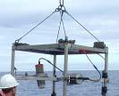
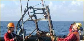

10 The Right People Bathymetry 10


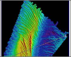
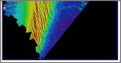
11 Sea Bed Features Sub-bottom Geology 11
12 Survey Scope Phase 2 - Geotechnics Thickness and properties of seabed layers Complexity of the geological model Presence and distribution of hazardous layers Variability and uncertainty in geotechnical parameters Number of CPT tests vs. Number of Boreholes The Right Drill Vessels 12

13 The Right Equipment The Right People 13


14 Geotechnical Surveys Provide Refined geological model Variation in ground conditions Idealised ground profile at foundation location Geotechnical parameters for foundation design Identification of geotechnical hazards Geotechnical Survey Results 14
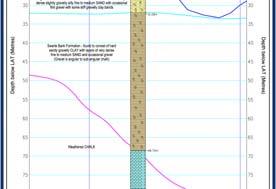
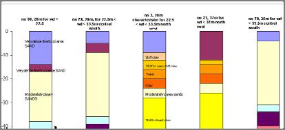

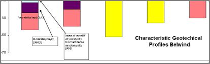
15 Geotechnical Survey Results Refined Geological Model 15


16 Parameters for Foundation Design Metocean Data 16
17 Metocean Data Data Integration and Reporting Data comparison over time 17


18 Data Integration and Reporting Wind turbine suitability mapping: Data Integration and Reporting 3D visualisation example with data from different sources: 18


19 Foundation Design Length Diameter scour protection mudline scour hole Foundation Design 19
20 Foundation Design Questions Mattijs de Lange Gardline Marine Sciences Limited 20
Data and Information Management. UK All Energy 22 nd May Presented by Leo James
 Data and Information Management UK All Energy 22 nd May 2013 Presented by Leo James Strategic Development Plans Observations at the outset Data and information management and dissemination: company or
Geophysical Site Surveys
 Geophysical Site Surveys Simon Oakley Geoscience Team Leader Fugro Survey Limited 16/04/2014 Contents Menu Introduction Section 1 - Geophysical Site Surveys - Seabed Bathymetry - Shallow Geology - Seabed
Deep Water Marine Surveys
 Deep Water Marine Surveys Deep Sea International Consortium Workshop Rio de Janeiro, February 01st & 2nd Fred Marins Marketing Director fred.marins@gardline.com.br Key Aspects Gardline: Since 1969 + 1500
IOGP Hazard Survey Guidelines and Technical Notes. Andy W Hill, BP America, March 2016
 IOGP Hazard Survey Guidelines and Technical Notes Andy W Hill, BP America, March 2016 Summary Background to the IOGP Guidelines for the Conduct of Offshore Drilling Hazard Site Surveys (DHSS) Objective
Guidelines for the conduct of offshore drilling hazard site surveys
 Guidelines for the conduct of offshore drilling hazard site surveys Report No. 373-18-1 April 2011 International Association of Oil & Gas Producers P ublications Global experience The International Association
Numerical crashworthiness analysis of an offshore wind turbine monopile impacted by a ship
 Analysis and Design of Marine Structures Guedes Soares & Shenoi (Eds) 2015 Taylor & Francis Group, London, ISBN 978-1-138-02789-3 Numerical crashworthiness analysis of an offshore wind turbine monopile
Managing bathymetric data in a hydrographic survey company
 Managing bathymetric data in a hydrographic survey company Overview Brief Introduction to MMT How MMT use GIS Why we need to manage bathy data The BIS Inputting Data to the BIS Using the BIS GIS Product
FOUNDATIONS FOR OFFSHORE STRUCTURES
 FOUNDATIONS FOR OFFSHORE STRUCTURES DELHI CHAPTER Pradeep Hora It takes less time to do a thing right than explain why you did it wrong. - Henry Wadsworth Longfellow 2 1 Site Investigations (Survey) What
BELFAST SEWERS PROJECT
 BELFAST SEWERS PROJECT Adam Green - Atkins Tunnelling Scheme Overview New stormwater interceptor Tunnel Scheme within Belfast City Centre to alleviate flooding and divert storm water flows from existing
GUIDANCE D. Part D: Guidelines for the geotechnical investigation and assessment of subdivisions in the Canterbury region.
 GUIDANCE D CONTENTS Part D: Guidelines for the geotechnical investigation and assessment of subdivisions in the Canterbury region Minimum requirements for geotechnical assessment for land development (
RECOMMENDED PRACTICE FOR SITE SPECIFIC ASSESSMENT OF MOBILE JACK-UP UNITS
 RECOMMENDED PRACTICE FOR SITE SPECIFIC ASSESSMENT OF MOBILE JACK-UP UNITS GULF OF MEXICO ANNEX Revision 0 September 2007 Rev Issue Date Details 0 September 2007 Submitted to SNAME OC7 for Adoption Introduction:
Exploitation of Ocean Predictions by the Oil and Gas Industry. GODAE OceanView Symposium 2013
 Exploitation of Ocean Predictions by the Oil and Gas Industry GODAE OceanView Symposium 2013 Introduction Information needs Challenges Acknowledgements IMarEST/SUT Metocean Awareness Course Colleagues
The Arctic - A New Frontier The geological, environmental and engineering challenges for submarine telecommunication cables
 The Arctic - A New Frontier The geological, environmental and engineering challenges for submarine telecommunication cables Ryan Wopschall 5 September 2013 Oceanology International China, Shanghai Fugro
Prof. Dr.-Ing. Martin Achmus Institute of Soil Mechanics, Foundation Engineering and Waterpower Engineering. Offshore subsoil investigations
 Prof. Dr.-Ing. Martin Achmus Institute of Soil Mechanics, Foundation Engineering and Waterpower Engineering Offshore subsoil investigations Addis Ababa, September 2010 Offshore subsoil investigations Presentation
Appendix 3: Sæby Offshore Wind Farm Technical Description, Offshore
 Appendix 3: Sæby Offshore Wind Farm Technical Description, Offshore Appendix 3: Sæby Offshore Wind Farm Technical Description, Offshore Appendix 3: Sæby Offshore Wind Farm Technical Description, Offshore
ENERGIES MARINES RENOUVELABLES: Géotechnique & Fondations Hong DOAN & Denys BOREL. Rencontre des partenaires WeAMEC du 7 avril 2017
 ENERGIES MARINES RENOUVELABLES: Géotechnique & Fondations Hong DOAN & Denys BOREL Rencontre des partenaires WeAMEC du 7 avril 2017 Ground model - Making the Development Site Transparent Starting Point
Impact of Noise on the Marine Environment a Regulatory Perspective
 Impact of Noise on the Marine Environment a Regulatory Perspective John Hartley Hartley Anderson Ltd. Photographs courtesy of JNCC Over-arching Objective Minimise the Impact of Oil and Gas Activities &
Chapter 16 Marine Archaeology and Cultural Heritage
 East Anglia TWO Offshore Windfarm Chapter 16 Marine Archaeology and Cultural Heritage Preliminary Environmental Information Volume 1 Document Reference: EA2-DEVWF-ENV-REP-IBR-000811 Prepared by: Paolo
Implementation of the Political Declaration on energy cooperation between the North Seas Countries. Support Group 1 on Maritime Spatial Planning
 Implementation of the Political Declaration on energy cooperation between the North Seas Countries Support Group 1 on Maritime Spatial Planning Work Programme 1. Work area as outlined in Annex I to the
East Anglia ONE North Offshore Windfarm. Chapter 16 Marine Archaeology and Cultural Heritage
 East Anglia ONE North Offshore Windfarm Chapter 16 Marine Archaeology and Cultural Heritage Preliminary Environmental Information Volume 1 Document Reference: EA1N-DEVWF-ENV-REP-IBR000285 Prepared by:
Remote Sensing Techniques for Renewable Energy Projects. Dr Stuart Clough APEM Ltd
 Remote Sensing Techniques for Renewable Energy Projects Dr Stuart Clough APEM Ltd What is Remote Sensing? The use of aerial sensors to detect and classify objects on Earth Remote sensing for ecological
Regional-scale understanding of the geologic character and sand resources of the Atlantic inner continental shelf, Maine to Virginia
 Regional-scale understanding of the geologic character and sand resources of the Atlantic inner continental shelf, Maine to Virginia Workshop on Dredging, Beach Nourishment and Bird Conservation Atlantic
GEOTECHNICAL ENGINEERING II. Subject Code : 06CV64 Internal Assessment Marks : 25 PART A UNIT 1
 GEOTECHNICAL ENGINEERING II Subject Code : 06CV64 Internal Assessment Marks : 25 PART A UNIT 1 1. SUBSURFACE EXPLORATION 1.1 Importance, Exploration Program 1.2 Methods of exploration, Boring, Sounding
Geological information for Europe : Towards a pan-european Geological Data Infrastructure
 Geological information for Europe : Towards a pan-european Geological Data Infrastructure Integrating geoscientific information for EU competitiveness Co-funded by the European Union European societal
Marine Geophysical Methods: What Can and Cannot Be Done to Iden8fy Hazards to Dredging & Marine Construc8on
 Marine Geophysical Methods: What Can and Cannot Be Done to Iden8fy Hazards to Dredging & Marine Construc8on Marine Geophysics Sham or Savior? Seen alternatively as the silver bullet or snake oil, marine
Foundation models for the dynamic response of offshore wind turbines
 Marine Renewable Energy Conference (MAREC), Newcastle, UK, September 00. Foundation models for the dynamic response of offshore wind turbines. M.B. Zaaijer, MSc Delft University of Technology, The Netherlands
Marine Heat Flow Measurements Information Brochure
 Marine Heat Flow Measurements Information Brochure 5 1 2 3 4 5 5 6 7 8 5 9 10 11 12 13 14 5 15 16 17 18 19 20 21 5 22 0 200 400 600 800 1000 1200 1400 1600 Time (s) What is the use of heat flow measurements?
Preliminary Geotechnical and Environmental Report
 ` Preliminary Geotechnical and Environmental Report (Volume 2) December 2011 THIS PAGE INTENTIONALLY LEFT BLANK VOLUME 2 Summary As part of PE phase, the following investigations were performed: Geotechnical
OFFSHORE SURVEY IN THE OIL & GAS INDUSTRY WHAT S THAT ALL ABOUT? Ian Douglas Head, Offshore Surveys, Shell Projects & Technology Europe
 OFFSHORE SURVEY IN THE OIL & GAS INDUSTRY WHAT S THAT ALL ABOUT? Ian Douglas Head, Offshore Surveys, Shell Projects & Technology Europe Hydrofest 2014 13 March 2014 1 Why Position Matters The Exploration
Hydrofest The Hydrographic Society in Scotland
 Hydrofest 2017 The Hydrographic Society in Scotland Offshore Survey in the Oil and Gas Industry Hydrofest 2017 Chris Leaf Head Offshore Surveys Shell Projects and Technology, Europe Presentation Overview
Environmental Geophysics for Coastal Management
 Environmental for Coastal Management Paul Donaldson 1, Dr Douglas Bergersen 2, Dr Matthew Barnes 3, Conor Jones 3 Coast To Coast, Hobart April 2018 1 BMT Newcastle, Australia, 2 Acoustic Imaging, Cooroy,
Coring and sediment sampling
 Coring and sampling Principle: In order to ground-truth geophysical data, it is necessary to obtain a sample of the seabed. There are two main techniques available for sampling unconsolidated s : (1) seabed
Geography 3202 Unit 4 S.C.O. 4.3 & 4.5. Primary Resource Activities Offshore Oil And Gas
 Geography 3202 Unit 4 S.C.O. 4.3 & 4.5 Primary Resource Activities Offshore Oil And Gas Factors Affecting The Decision To Recover Offshore Oil And Gas (4.3.1) Physical Factors 1. Ocean Related Factors
NOAA Nautical Charts and Coastal and Marine Spatial Planning. Meredith Westington Chief Geographer NOAA/NOS/Office of Coast Survey
 NOAA Nautical Charts and Coastal and Marine Spatial Planning Meredith Westington Chief Geographer NOAA/NOS/Office of Coast Survey Ocean Policy Task Force What is CMSP? A comprehensive, adaptive, integrated,
IAEA SAFETY STANDARDS Geotechnical Aspects of Site Evaluation and Foundations in NPPs, NS-G-3.6
 IAEA SAFETY STANDARDS Geotechnical Aspects of Site Evaluation and Foundations in NPPs, NS-G-3.6 Regional Workshop on Volcanic, Seismic, and Tsunami Hazard Assessment Related to NPP Siting Activities and
NEW SEAFLOOR INSTALLATIONS REQUIRE ULTRA-HIGH RESOLUTION SURVEYS
 NEW SEAFLOOR INSTALLATIONS REQUIRE ULTRA-HIGH RESOLUTION SURVEYS Donald Hussong (Fugro Seafloor Surveys, Inc.) dhussong@fugro.com Fugro Seafloor Surveys, Inc., 1100 Dexter Avenue North (Suite 100), Seattle,
Guidelines for Site-Specific Seismic Hazard Reports for Essential and Hazardous Facilities and Major and Special-Occupancy Structures in Oregon
 Guidelines for Site-Specific Seismic Hazard Reports for Essential and Hazardous Facilities and Major and Special-Occupancy Structures in Oregon By the Oregon Board of Geologist Examiners and the Oregon
Introduction to Acoustic Remote Sensing and Seafloor Mapping (AE4-E13) May 19, 2010
 May 19, 2010") Introduction to Acoustic Remote Sensing and Seafloor Mapping (AE4-E13) May 19, 2010 1 Delft Vermelding Institute onderdeel of Earth organisatie Observation and Space Systems Why Acoustic Remote Sensing?
Introduction to Acoustic Remote Sensing and Seafloor Mapping (AE4-E13) May 19, 2010 1 Delft Vermelding Institute onderdeel of Earth organisatie Observation and Space Systems Why Acoustic Remote Sensing?
BAUER MeBo Sea Bed Drill Rig
 BAUER MeBo Sea Bed Drill Rig Spotlights BAUER Maritime Experiences 1993 Diamond deposit exploration with a BC cutter in water depth of 160 m (South Africa) Atlantic Ocean 2005 Drilling inside of a monopile
Developing a Seabed Resurvey Strategy: A GIS approach to modelling seabed changes and resurvey risk
 Developing a Seabed Resurvey Strategy: A GIS approach to modelling seabed changes and resurvey risk A. M. Bakare, J. G. Morley, R. R. Simons Department of Geomatic Engineering, University College London,
THE 4Gs IN PRACTICE: INVESTIGATING HOW THE 4Gs ARE APPLIED IN THE OIL & GAS INDUSTRY
 THE 4Gs IN PRACTICE: INVESTIGATING HOW THE 4Gs ARE APPLIED IN THE OIL & GAS INDUSTRY Society for Underwater Technology, Evening Technical Meeting 14 AUGUST 2013 GEOPHYSICS & PORT DEVELOPMENTS EXPLORING
Exploration, Drilling & Production
 Nontechnical Guide to PETMOLEUM Geology, Exploration, Drilling & Production Third Edition Norman J. Hyne, Ph.D. Contents Preface *i Introduction 1 The Nature of Gas and Oil 1 Petroleum 1 The Chemistry
Geophysical Site Investigation (Seismic methods) Amit Prashant Indian Institute of Technology Gandhinagar
 Amit Prashant Indian Institute of Technology Gandhinagar") Geophysical Site Investigation (Seismic methods) Amit Prashant Indian Institute of Technology Gandhinagar Short Course on Geotechnical Aspects of Earthquake Engineering 04 08 March, 2013 Seismic Waves
Geophysical Site Investigation (Seismic methods) Amit Prashant Indian Institute of Technology Gandhinagar Short Course on Geotechnical Aspects of Earthquake Engineering 04 08 March, 2013 Seismic Waves
ALASKA DEEP-DRAFT ARCTIC PORT EVALUATION
 ALASKA DEEP-DRAFT ARCTIC PORT EVALUATION Joint Study of Federal and State June 20, 2012 Opportunity and Constraint Warming of Arctic region is leading to new maritime opportunities. Thawing of permafrost
Non-Technical Summary
 Non-Technical Summary Proposed Project TGS-NOPEC Geophysical Company ASA (TGS) proposes to undertake a two dimensional (2D) seismic survey and seabed sampling in the western Greenland Sea off North East
Offshore wind foundations design, installation and monitoring
 Offshore wind foundations design, installation and monitoring Innovation Day Clean Energy Seminar, Innovation Norway 28 September Millenium Hilton Seoul Yunsup Shin, Per Sparrevik Norwegian Geotechnical
Fish and Fish Habitat Follow-up Program. Scotian Basin Exploration Project
 Fish and Fish Habitat Follow-up Program Scotian Basin Exploration Project April 2018 Contents 1 Introduction... 1 2 Scope... 1 3 EIS Commitments and Predictions... 2 4 Methodology and Reporting... 2 4.1
Marine Spatial Planning as an important tool for implementing the MSFD
 Marine Spatial Planning as an important tool for implementing the MSFD Risto Kalliola Tallinn, Nov. 16 th 2012 DEPARTMENT OF GEOGRAPHY AND GEOLOGY University of Turku, Finland Ten principles to provide
HORDA SURVEY HERALDS NEW STRATEGY
 HORDA SURVEY HERALDS NEW STRATEGY CGG sets sights on multi-client market leadership in Norway BY IDAR HORSTAD, ERLING FRANTZEN AND JO FIRTH, CGG 12 seismic profile Figure 1: Reprocessing of the Cornerstone
ENCE 3610 Soil Mechanics. Site Exploration and Characterisation Field Exploration Methods
 ENCE 3610 Soil Mechanics Site Exploration and Characterisation Field Exploration Methods Geotechnical Involvement in Project Phases Planning Design Alternatives Preparation of Detailed Plans Final Design
Marine environment monitoring : The basic requirements to support Marine Renewable Energies
 Marine environment monitoring : The basic requirements to support Marine Renewable Energies SHOM in brief SHOM is the French Government agency in charge of Hydrography and Oceanography SHOM s vocation
Offshore Operations and Project Execution Geophysical Site Surveys
 Offshore Operations and Project Execution Geophysical Site Surveys Chris Almond Senior Geophysicist Fugro Survey Limited 22/04/2015 Presentation Summary: Office-based Personnel Project Awarded Pre Offshore
Environmental Data In Support of Search & Rescue Operations in the Central Mediterranean Sea
 Environmental Data In Support of Search & Rescue Operations in the Central Mediterranean Sea Dr. Eric Comerma (RPS ASA) eric.comerma@rpsgroup.com Cathleen Turner (RPS ASA) Prof. Aldo Drago (Univ. of Malta)
Smart Survey Approach: Multibeam Echosounder and Integrated Water Column Data as an Added Value for Seep Hunting
 Smart Survey Approach: Multibeam Echosounder and Integrated Water Column Data as an Added Value for Seep Hunting HYDRO 2016 8 November 2016 Marco Filippone Introduction, Multibeam Sonars & water column
A national 3D geological model of Denmark: Condensing more than 125 years of geological mapping
 A national 3D geological model of Denmark: Condensing more than 125 years of geological mapping Peter B.E. Sandersen Thomas Vangkilde-Pedersen Geological Survey of Denmark and Greenland Flemming Jørgensen
7B.4 ASSESSMENT OF THE GROSS U.S. OFFSHORE WIND ENERGY POTENTIAL
 7B.4 ASSESSMENT OF THE GROSS U.S. OFFSHORE WIND ENERGY POTENTIAL Marc Schwartz, Donna Heimiller, Steve Haymes, and Walt Musial National Renewable Energy Laboratory, Golden, Colorado 1. INTRODUCTION Offshore
PETROLEUM 101. Mark Shrimpton Jacques Whitford
 PETROLEUM 101 Mark Shrimpton Jacques Whitford PRESENTATION STRUCTURE The Offshore Petroleum Industry Petroleum Geology Petroleum Technology: Exploration agreements Geophysical exploration Drilling Development
10. GEOTECHNICAL EXPLORATION PROGRAM
 Geotechnical site investigations should be conducted in multiple phases to obtain data for use during the planning and design of the tunnel system. Geotechnical investigations typically are performed in
Common Exploration Methods.
 Common Exploration Methods. The following list contains the most common methods which a company with a mineral prospecting licence in Northern Ireland might use to carry out a mineral prospecting programme.
CHARACTERIZATION OF SOFT CLAY- A CASE STUDY AT CRANEY ISLAND
 National Defense Industrial Association 2005 Tri-Service Infrastructure Systems Conference and Exhibition Re-Energizing Engineering Excellence CHARACTERIZATION OF SOFT CLAY- A CASE STUDY AT CRANEY ISLAND
Unexploded Ordnance on Auckland s Doorstep. WasteMINZ November 2017
 Unexploded Ordnance on Auckland s Doorstep WasteMINZ November 2017 Scope Site Background. Site Assessment. Geophysical Survey. Investigation. Findings. Challenges. Key Points. Weiti Bay Site Access Road
SITE INVESTIGATION 1
 SITE INVESTIGATION 1 Definition The process of determining the layers of natural soil deposits that will underlie a proposed structure and their physical properties is generally referred to as site investigation.
EO-Based Ice and Iceberg Monitoring in Support of Offshore Engineering Design and Tactical Operations
 EO-Based Ice and Iceberg Monitoring in Support of Offshore Engineering Design and Tactical Operations Desmond Power, C-CORE ESA Industry Workshop on Satellite EO for the Oil and Gas Sector Overview Operations
Initial Borehole Drilling and Testing in Central Huron,
 JULY 2016 PRELIMINARY ASSESSMENT OF POTENTIAL SUITABILITY Initial Borehole Drilling and Testing in Central Huron, Huron-Kinloss and South Bruce DRAFT FOR DISCUSSION WITH COMMUNITIES In 2012, at the request
Overview of Engineering. Risk Management for Successful Wind Energy Development, Offshore U.S.
 Overview of Engineering Considerations for Siting and Risk Management for Successful Wind Energy Development, Offshore U.S. Bi Briefing for: North Carolina Offshore Wind Task Force Tom McNeilan, P.E. General
Imaging Deep into the Gulf of
 TECHNOLOGY EXPLAINED Imaging Deep into the Gulf of Houston Houston The Gulf of Mexico as viewed from space. This Mediterraneantype sea is located at the southeastern corner of North America. It covers
Page 1. A Grieg Group Company
 Page 1 ECDIS PAST, PRESENT & Future 2000-2010 Past Present 2010-2015 2015... Future Page 2 History Page 3 DEEPLY - Past What is going on there????? I am Checking now Sir Page 4 ECDIS History ECDIS has
MITIGATING DREDGING RISKS USING ENHANCED GEOPHYSICAL METHODS: THE AQUARES RESISTIVITY METHOD
 MITIGATING DREDGING RISKS USING ENHANCED GEOPHYSICAL METHODS: THE AQUARES RESISTIVITY METHOD P. M. Brabers 1, J.F. Sawyer 2 and J. Errey 3 ABSTRACT The development of a new or an existing port involving
Natura 2000 in the marine environment: state of implementation and next steps
 Life on the blue planet: biodiversity research and the new European marine policies EPBRS European Platform on Biodiversity Research Strategy Porto, Portugal 7-9 November 2007 Natura 2000 in the marine
APPENDIX H SOIL SURVEY
 Environmental Impact Statement Beryl Solar Farm APPENDIX H SOIL SURVEY Beryl Solar Farm 16 347 Final V1 H i Geotechnical Engineers & Engineering Geologists NATA Accredited Laboratories for Asphalt, Aggregate,
An Overview of Geomatics Involvement in the Offshore Oil & Gas Industry
 An Overview of Geomatics Involvement in the Offshore Oil & Gas Industry David Whitcombe Head Offshore Surveys - Europe Explore Appraise Develop ProduceDecommission Content Overview Oil & Gas Industry Geomatics
Bathymetry. EMODnet Stakeholder Conference & Sea-basin Workshops February Bathymetry
 EMODnet Stakeholder Conference & Sea-basin Workshops 14-15 February 2017 Arctic checkpoint Belinda Kater On behalf of all Checkpoints http://www.emodnet.eu 1 ? is the study of the "beds" or "floors" of
Economic and Social Council 10 July 2013
 ADVANCE UNEDITED VERSION UNITED NATIONS E/C.20/2013/10/Add.1 Economic and Social Council 10 July 2013 Committee of Experts on Global Geospatial Information Management Third session Cambridge, United Kingdom
ICE PRESSURE RIDGE IMPACTS ON OIL SPILLS IN THE ALASKAN OCS
 Ice in the Environment: Proceedings of the 16th IAHR International Symposium on Ice Dunedin, New Zealand, 2nd 6th December 2002 International Association of Hydraulic Engineering and Research ICE PRESSURE
SI Planning & Laboratory Testing for Hill-Site Development
 SI Planning & Laboratory Testing for Hill-Site Development 21 April 2009 IEM Penang Ir. Tan Yean Chin G&P Geotechnics Sdn Bhd Cameron Highlands, 1961 Genting Highland Tower 1993 Bukit Antarabangsa, 1999
The Spatial Offshore Grid Plan for the German Exclusive Economic Zone
 11 2 The Spatial Offshore Grid Plan for the German Exclusive Economic Zone Annika Koch 2.1 Legal mandate 12 2.2 Accompanying Strategic Environmental Assessment 12 2.3 Results of the Environmental Report
petroleum exploration You are an exploration team in charge of a new petroleum province Your task is to get maximum return on investment (ROI)
") Purpose: Enhance your overall understanding of petroleum exploration Multidisciplinary challenge You are an exploration team in charge of a new petroleum province Your task is to get maximum return on
Purpose: Enhance your overall understanding of petroleum exploration Multidisciplinary challenge You are an exploration team in charge of a new petroleum province Your task is to get maximum return on
STAMP Spa)al Tools for Arc)c Mapping & Planning. Creating an interactive data tool to improve access and usability of Arctic data
al Tools for Arc)c Mapping & Planning. Creating an interactive data tool to improve access and usability of Arctic data") STAMP Spa)al Tools for Arc)c Mapping & Planning Creating an interactive data tool to improve access and usability of Arctic data Mission Provide easy access to physical, chemical, and biological data Network
STAMP Spa)al Tools for Arc)c Mapping & Planning Creating an interactive data tool to improve access and usability of Arctic data Mission Provide easy access to physical, chemical, and biological data Network
Regulations concerning protection of Bjørnøya Nature Reserve in Svalbard
 Regulations concerning protection of Bjørnøya Nature Reserve in Svalbard Laid down by the Royal Decree of 16 August 2002 pursuant to sections 12 and 17 of the Act of 15 June 2001 No. 79 relating to the
Geophysics for Land Development
 Geophysics for Land Development About Us Whatever your area of interest GBGMAPS can provide advanced subsurface and structural geophysical solutions to add value to your product. Mining and infrastructure
Nord Stream 2 A story of gas pipelines and GIS technology from the start. Cécile Noverraz GIS Analyst
 Nord Stream 2 A story of gas pipelines and GIS technology from the start 30-10-2018 Cécile Noverraz GIS Analyst Presentation - Outline >Project Overview > Initial GIS Project Setup > Project Data > GIS
TATA CHEMICALS MAGADI LIMITED (Mining Section) TRONA CRUSHING PLANT AND PREWASH TANK FACILITY PROJECT
 TRONA CRUSHING PLANT AND PREWASH TANK FACILITY PROJECT") 1 TATA CHEMICALS MAGADI LIMITED (Mining Section) TRONA CRUSHING PLANT AND PREWASH TANK FACILITY PROJECT RFQ for Geotechnical Investigations and Foundation Recommendations TCML/MS/RFQ1/2017 October 2017
1 TATA CHEMICALS MAGADI LIMITED (Mining Section) TRONA CRUSHING PLANT AND PREWASH TANK FACILITY PROJECT RFQ for Geotechnical Investigations and Foundation Recommendations TCML/MS/RFQ1/2017 October 2017
Byblos & the Sea - an HFF funded project Summary report: Sea Survey Mission 7 - Sept. 2016
 Byblos & the Sea - an HFF funded project Summary report: Sea Survey Mission 7 - Sept. 2016 In the framework of the research program Byblos and the Sea a marine remote sensing and sampling survey was carried
GLOBAL WIND ENERGY SHIPPING AND LOGISTICS M A R C H 1 3, , C O P E N H A G E N, D E N M A R K
 GLOBAL WIND ENERGY SHIPPING AND LOGISTICS SUPPLY CHAINS WITHIN DIFFERENT LIFE-CYCLES OF AN OFFSHORE WIND FARM M A R C H 1 3, 2 0 1 5, C O P E N H A G E N, D E N M A R K Prepared for the Global Wind Conference
Programmatic Approaches to Assessing and Mitigating Risk to Pipelines from Natural Forces
 Programmatic Approaches to Assessing and Mitigating Risk to Pipelines from Natural Forces 23 rd International Petroleum Environmental Conference New Orleans, Louisiana November 8-10, 2016 Introduction
Department of National Defence B-Jetty Reconstruction
 Department of National Defence B-Jetty Reconstruction CFB Esquimalt, BC Presented by: Stantec & Golder Associates February 2, 2016 Agenda 1 B-Jetty Project Background 2 Distinguishing Project Features
Aquaculture Spatial Planning: The case of Greece
 Aquaculture Spatial Planning: The case of Greece Nikos Anagnopoulos Panhellenic Association for Small-Medium sized Aquaculture Enterprises Panhellenic Association for Small-Medium sized Aquaculture Enterprises
1. Baltic SCOPE Towards coherence and cross-border solutions in Baltic Maritime Spatial Plans
 NSHC 32th Conference Explanatory Note Dublin, Ireland Item E.2 MSP 21-23 June 2016 Germany Cross border MSP for the EEZ, a case study from the Baltic Sea The Federal Maritime and Hydrographic Agency of
BLOCKS 5 (ANY), 6 (PITU) AND 8 (NAPU)
, 6 (PITU) AND 8 (NAPU)") August, 2013 SHELL GREENLAND 2013 SITE SURVEY IN BAFFIN BAY BLOCKS 5 (ANY), 6 (PITU) AND 8 (NAPU) FINAL EIA - ADDITIONAL WORK SCOPE NON-TECHNICAL SUMMARY 2013 SITE SURVEY IN BAFFIN BAY BLOCKS 5 (ANY),
August, 2013 SHELL GREENLAND 2013 SITE SURVEY IN BAFFIN BAY BLOCKS 5 (ANY), 6 (PITU) AND 8 (NAPU) FINAL EIA - ADDITIONAL WORK SCOPE NON-TECHNICAL SUMMARY 2013 SITE SURVEY IN BAFFIN BAY BLOCKS 5 (ANY),
Contents... i. List of Tables... iii. List of Figures... iv. Glossary... v. Abbreviations and Acronyms... vi. 10 Metocean and Coastal Processes...
 Contents Contents... i List of Tables... iii List of Figures... iv Glossary... v Abbreviations and Acronyms... vi Metocean and Coastal Processes... 1.1 Introduction... 1.1.1 Consultation... 2.1.2 Policy
National Marine Sanctuary Program
 National Marine Sanctuary Program NMSP/USGS Joint Seabed Mapping Initiative: September 2004 AA National Ocean Service National Marine Sanctuaries Interim Report September 2004 Background: Since 2002,
SPLAN-Natura Towards an integrated spatial planning approach for Natura th January, 2017 Brussels. Commissioned by DG Environment
 SPLAN-Natura 2000 Towards an integrated spatial planning approach for Natura 2000 Commissioned by DG Environment 17 th January, 2017 Brussels V. Simeonova (Ph.D.) Drivers towards integrating Biodiversity
Outline National legislative & policy context Regional history with ESSIM ESSIM Evaluation Phase Government Integration via RCCOM Regional ICOM Framew
 What MSP Implementation could change in the Maritimes Region Tim Hall, Regional Manager Oceans and Coastal Management Division Ecosystem Management Branch Fisheries and Oceans Canada Maritimes Region BIO
A National Outer Continental Shelf Sand / Sediment Inventory
 A National Outer Continental Shelf Sand / Sediment Inventory Sand Resource Areas Lease Areas Lora Turner December 15, 2016 Restoring and Protecting Our Nation s Coasts through Stewardship of OCS Resources
Ocean Structures and Materials Dr. Srinivasan Chandrasekaran Department of Ocean Engineering Indian Institute of Technology, Madras
 Ocean Structures and Materials Dr. Srinivasan Chandrasekaran Department of Ocean Engineering Indian Institute of Technology, Madras Module - 1 Lecture - 5 Drill ships and basics of drilling Welcome to
Initial Borehole Drilling and Testing in or Near Ignace
 JUNE 2016 PRELIMINARY ASSESSMENT OF POTENTIAL SUITABILITY Initial Borehole Drilling and Testing in or Near Ignace DRAFT FOR DISCUSSION WITH COMMUNITIES In 2010, the Nuclear Waste Management Organization
Engineering in Support of Transformative Science
 Engineering in Support of Transformative Science Scientific Ocean Drilling of Mid-Ocean Ridge and Ridge-Flank Setting Workshop August 27, 2009 Austin, Texas Greg Myers IODP-MI Outline o Main engineering
Universal Foundation Suction Bucket
 A solution in support for offshore wind Henrik Lundorf Nielsen April 2013 The Evolution of Innovative yet years of experience: 1997 TekNord 1999 MIG Business Development 2002 Prototype 1 2001 MBD Offshore
June 9, R. D. Cook, P.Eng. Soils Engineer Special Services Western Region PUBLIC WORKS CANADA WESTERN REGION REPORT ON
 PUBLIC WORKS CANADA WESTERN REGION REPORT ON GEOTECHNICAL INVESTIGATION PROPOSED MARTIN RIVER BRIDGE MILE 306.7 MACKENZIE HIGHWAY Submitted by : R. D. Cook, P.Eng. Soils Engineer Special Services Western
Maritime Safety Services. Supporting Safe and Efficient Transfer Operations
 Maritime Safety Services Supporting Safe and Efficient Transfer Operations Charles Tait 06 Ship to Ship (STS) Transfer is a critical and important, daily activity in the support of, and delivery of, Offshore