Managing bathymetric data in a hydrographic survey company
|
|
|
- Emma Woods
- 5 years ago
- Views:
Transcription


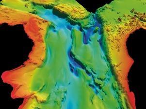
1 Managing bathymetric data in a hydrographic survey company

2 Overview Brief Introduction to MMT How MMT use GIS Why we need to manage bathy data The BIS Inputting Data to the BIS Using the BIS GIS Product workflows
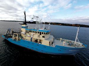
 established 2002 Offices in Gothenburg, Sweden & Banbury, UK Privately owned 220 specialists 6 vessels")
3 Company Profile High Resolution Seabed Mapping, Pipeline, Geophysical and Geotechnical Surveying MMT Swedish company founded in 1976, MMT UK (NetSurvey) established 2002 Offices in Gothenburg, Sweden & Banbury, UK Privately owned 220 specialists 6 vessels

4 Market segments & Clients Oil & Gas Pipeline route survey Site survey Pipeline inspections Renewables Wind park surveys Site surveys wave & tidal energy Hydrographic Large scale IHO mapping Enviromental Environmental impact assessment Habitat mapping Species Assessment Cables Power cable route survey Telecommunication cable survey

5 Folder View For a spatially aware profession we have a strange view of file storage!

6 iphoto - Even my home computer has better spatial awareness!


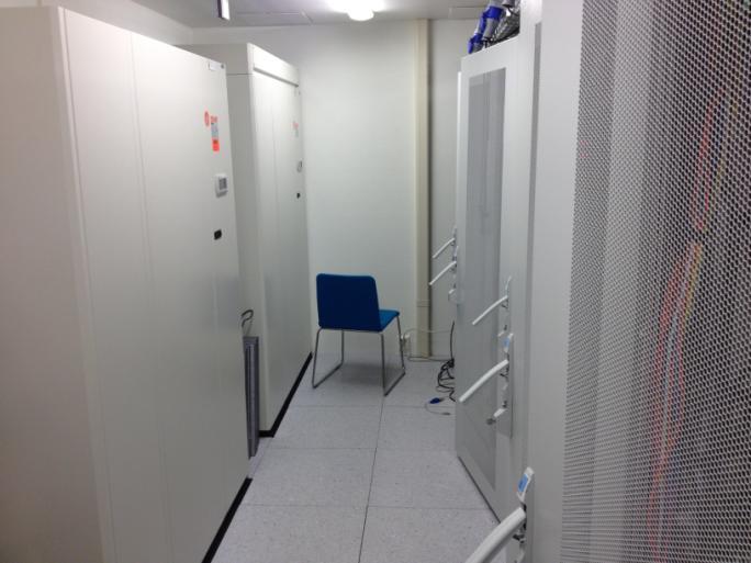

7 IT naughty chair! The problem
8 DO WE PRODUCE SEABED MAPS OR CHARTS? WHAT TYPES OF PRODUCT DO WE NEED TO CREATE?


 Sharing")
9 Advantages Structured system Consistency Quality Control Scalability (single file to Enterprise) Integration (CAD, Fledermaus, Kingdom, FME) Sharing (e.g. via FME Spatial ETL) Time / Cost effective

10 Spatial View

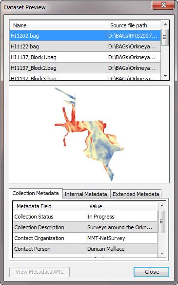
11 Spatial View Outline of individual surveys shown in green


12 Spatial View Previews of individual surveys with associated metadata


13 ArcGIS for Maritime: Bathymetry Part of the ArcGIS system ArcGIS Hydrographic Office Systems Charting Surveys Bathymetry Soundings Fledermaus Thinning Processing Depth curves 3D visualization Profiling Oceans GIS Ports Defense Energy Marine Science


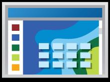


14 ArcGIS for Maritime: Bathymetry Register Explore Compose Share Gridded data Surfaces 5 2 Features Collections BIS Metadata Queries
 are referenced rather than duplicated.")
15 Inputting data into the BIS Bathymetric Attributed Grids (BAGs) are referenced rather than duplicated.

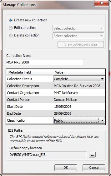
16 Creating a BIS and Setting Up Collections

17 Loading the BIS

18 Using the BIS Viewing data by vessel Hydrographic Survey consisting from 4 different vessels

19 Using the BIS Viewing data by vessel Data just from Survey Vessel Ping by filtering the other three vessels out


20 Using the BIS Combining datasets to create one huge surface Rules used to define how the surface is built; Newest first, highest accuracy, IHO Order number, Type of sonar.

21 Using the BIS Combining datasets to create one huge surface


22 Geospatial tools can then be applied to the one surface Usage: Route surveys, Pipeline surveys, Very large area surveys


23 MMT OPTIMISED GIS WORKFLOW Fledermaus

 ArcGIS Marine Data")

24 Example of Industry Standards OGP Seabed Survey Data Model (SSDM) ArcGIS Pipeline Data Model (APDM) ArcGIS Marine Data Model (AMDM) MMT GIS services Geographical Information System Page 24


")


25 GIS References. MMT GIS solutions are based on Industry Standards and Best Practice to match Client requirements Nord Stream Pipeline survey project (Enterprise solution) Centrica Wind farm UK survey project (File Geodatabase solution) NEMO HVDC survey project (File based solution)


26 Nord Stream Survey GIS 2008 GIS - Relational Database Model Oracle SE1 - ArcGIS Server/ ArcSDE - Several data sources/companies - Includes vector and raster data - Incorporates all data from the entire pre-installation survey project - Extended Metadata using attributes Advantages - Time / Cost Effective - Aid during survey and installation by data sharing - Flexibility and integrity based on platform - Incorporated Quality assurance and Quality control routines - High level of detail Challenges - Over unique Seabed objects - Multiple target inspection - Imagery and raster data handling

27 New ways to distribute the data
28 MEASURE THE DIFFERENCE!
Geog 469 GIS Workshop. Managing Enterprise GIS Geodatabases
 Geog 469 GIS Workshop Managing Enterprise GIS Geodatabases Outline 1. Why is a geodatabase important for GIS? 2. What is the architecture of a geodatabase? 3. How can we compare and contrast three types
ESRI Survey Summit August Clint Brown Director of ESRI Software Products
 ESRI Survey Summit August 2006 Clint Brown Director of ESRI Software Products Cadastral Fabric How does Cadastral fit with Survey? Surveyors process raw field observations Survey measurements define high-order
Nord Stream 2 A story of gas pipelines and GIS technology from the start. Cécile Noverraz GIS Analyst
 Nord Stream 2 A story of gas pipelines and GIS technology from the start 30-10-2018 Cécile Noverraz GIS Analyst Presentation - Outline >Project Overview > Initial GIS Project Setup > Project Data > GIS
Coast Survey Providing Improved Access to Maritime Navigation Products and Services
 Coast Survey Providing Improved Access to Maritime Navigation Products and Services Kurt A. Nelson, Branch Chief CGTP Leland Snyder, Branch Chief FADS Office of Coast Survey Agenda Current Coast Survey
Efficiencies in Data Acquisition and Transformation
 Efficiencies in Data Acquisition and Transformation Andrew LEYZACK Canada Key words: Hydrography, IHO S-57, Nautical Chart SUMMARY For many hydrographic offices, the introduction of electronic nautical
These modules are covered with a brief information and practical in ArcGIS Software and open source software also like QGIS, ILWIS.
 Online GIS Training and training modules covered are: 1. ArcGIS, Analysis, Fundamentals and Implementation 2. ArcGIS Web Data Sharing 3. ArcGIS for Desktop 4. ArcGIS for Server These modules are covered
Options in Capacity Building. Underpinning the Blue Economy. Slide 1/78. Derrick R. Peyton. 14 th MACHC Meeting. IIC Technologies. December 9-13, 2013
 Options in Capacity Building Underpinning the Blue Economy Derrick R. Peyton IIC Technologies 14 th MACHC Meeting December 9-13, 2013 Slide 1/78 Overview Blue Economy Defined Challenges (SDI, MSDI, Standards)
How does ArcGIS Server integrate into an Enterprise Environment? Willy Lynch Mining Industry Specialist ESRI, Denver, Colorado USA
 How does ArcGIS Server integrate into an Enterprise Environment? Willy Lynch Mining Industry Specialist ESRI, Denver, Colorado USA wlynch@esri.com ArcGIS Server Technology Transfer 1 Agenda Who is ESRI?
DP Project Development Pvt. Ltd.
 Dear Sir/Madam, Greetings!!! Thanks for contacting DP Project Development for your training requirement. DP Project Development is leading professional training provider in GIS technologies and GIS application
Innovation. The Push and Pull at ESRI. September Kevin Daugherty Cadastral/Land Records Industry Solutions Manager
 Innovation The Push and Pull at ESRI September 2004 Kevin Daugherty Cadastral/Land Records Industry Solutions Manager The Push and The Pull The Push is the information technology that drives research and
A New Approach to GIS at the Ministry for Primary Industries New Zealand
 A New Approach to GIS at the Ministry for Primary Industries New Zealand Alana Corney and André Post Geospatial Management Team www.mpi.govt.nz 1 Overview Who we are and what we do Our Approach Building
Automated Seabed Mapping and Data Delivery in the Cloud
 Automated Seabed Mapping and Data Delivery in the Cloud London, 2nd November 2017 11/20/2017 1 2 WE CALL IT SEABED INTELLIGENCE Ocean Infinity are explorers. We go to unmapped locations to survey the seabed
Geophysical Site Surveys
 Geophysical Site Surveys Simon Oakley Geoscience Team Leader Fugro Survey Limited 16/04/2014 Contents Menu Introduction Section 1 - Geophysical Site Surveys - Seabed Bathymetry - Shallow Geology - Seabed
The File Geodatabase API. Craig Gillgrass Lance Shipman
 The File Geodatabase API Craig Gillgrass Lance Shipman Schedule Cell phones and pagers Please complete the session survey we take your feedback very seriously! Overview File Geodatabase API - Introduction
INTRODUCTION TO ARCGIS Version 10.*
 Week 3 INTRODUCTION TO ARCGIS Version 10.* topics of the week Overview of ArcGIS Using ArcCatalog Overview of ArcGIS Desktop ArcGIS Overview Scalable desktop applications ArcView ArcEditor ArcInfo ArcGIS
ArcGIS. for Server. Understanding our World
 ArcGIS for Server Understanding our World ArcGIS for Server Create, Distribute, and Manage GIS Services You can use ArcGIS for Server to create services from your mapping and geographic information system
Geodatabase Programming with Python John Yaist
 Geodatabase Programming with Python John Yaist DevSummit DC February 26, 2016 Washington, DC Target Audience: Assumptions Basic knowledge of Python Basic knowledge of Enterprise Geodatabase and workflows
The Danish enterprise approach to create and publish nautical products.covering the waters along the west coast of Greenland
 The Danish enterprise approach to create and publish nautical products.covering the waters along the west coast of Greenland Charlotte Bjerregaard Overview of data, charts and tasks Old production/new
Reducing Complex Spatial Data Management Needs in and Upstream Oil and Gas Operations Team. Jason Wilson GIS Business Analyst SM Energy
 Reducing Complex Spatial Data Management Needs in and Upstream Oil and Gas Operations Team Jason Wilson GIS Business Analyst SM Energy Agenda About Myself and SM Energy The Challenge The Goal Solution
Geodatabase Programming with Python
 DevSummit DC February 11, 2015 Washington, DC Geodatabase Programming with Python Craig Gillgrass Assumptions Basic knowledge of python Basic knowledge enterprise geodatabases and workflows Please turn
Using OGC standards to improve the common
 Using OGC standards to improve the common operational picture Abstract A "Common Operational Picture", or a, is a single identical display of relevant operational information shared by many users. The
Esri Training by Microcenter Prepare to Innovate. Microcenter Course Catalog
 Esri Training by Microcenter Prepare to Innovate 2015 Instructor-Led Courses Microcenter Course Catalog ArcGIS Foundational Courses Designed to meet the learning needs of professionals whose GIS experience
Administering your Enterprise Geodatabase using Python. Jill Penney
 Administering your Enterprise Geodatabase using Python Jill Penney Assumptions Basic knowledge of python Basic knowledge enterprise geodatabases and workflows You want code Please turn off or silence cell
Inspire Conference Istanbul, 2012 Ralf Lindgren. Inspire Conference Istanbul, 2012 Ralf Lindgren
 Background A Baltic Sea Bathymetry Database Concept and Hans Öiås Swedish Maritime Administration Hydrographic Office A national directive: The Swedish Maritime Administration shall, in cooperation with
You are Building Your Organization s Geographic Knowledge
 You are Building Your Organization s Geographic Knowledge And Increasingly Making it Available Sharing Data Publishing Maps and Geo-Apps Developing Collaborative Approaches Citizens Knowledge Workers Analysts
The Danish enterprise approach to create and publish nautical products.covering the waters along the west coast of Greenland
 The Danish enterprise approach to create and publish nautical products.covering the waters along the west coast of Greenland Charlotte Bjerregaard Overview of data, charts and tasks Old production/new
GIS is a tool for Pipeline Management
 ESRI User Conference 2011 GIS is a tool for Pipeline Management Pacheco (1) (1) Position: GIS Supervisor for Compañía Operadora de LNG del Perú. Address: Jiron Villa Real de los Infantes 255 D604, La Molina.
TRANSVERSE GIS FOR TOTAL E&P NIGERIA - GEOPS
 TRANSVERSE GIS FOR TOTAL E&P NIGERIA - GEOPS Marc Roussel / Total H. ANEKE (Manager Survey & Geomatics) J-M. AMOUROUX (Head of Geomatics and Affiliate Transverse GIS Coordinator) TEPNG/TS/ECP/Survey &
Geodatabase Essentials Part One - Intro to the Geodatabase. Jonathan Murphy Colin Zwicker
 Geodatabase Essentials Part One - Intro to the Geodatabase Jonathan Murphy Colin Zwicker Session Path The Geodatabase - What is it? - Why use it? - What types are there? Inside the Geodatabase Advanced
Road Ahead: Linear Referencing and UPDM
 Road Ahead: Linear Referencing and UPDM Esri European Petroleum GIS Conference November 7, 2014 Congress Centre, London Your Work Making a Difference ArcGIS Is Evolving Your GIS Is Becoming Part of an
Introduction to Geographic Information Systems (GIS): Environmental Science Focus
: Environmental Science Focus") Introduction to Geographic Information Systems (GIS): Environmental Science Focus September 9, 2013 We will begin at 9:10 AM. Login info: Username:!cnrguest Password: gocal_bears Instructor: Domain: CAMPUS
Introduction to Geographic Information Systems (GIS): Environmental Science Focus September 9, 2013 We will begin at 9:10 AM. Login info: Username:!cnrguest Password: gocal_bears Instructor: Domain: CAMPUS
Experiences and Directions in National Portals"
 FIG Seminar on e-land Administration Innsbruck/Austria 2-4 June 2004 "ESRI's Experiences and Directions in National Portals" Kevin Daugherty Cadastral/Land Records Manager ESRI Topic Points Technology
Introduction to the 176A labs and ArcGIS
 Introduction to the 176A labs and ArcGIS Acknowledgement: Slides by David Maidment, U Texas-Austin and Francisco Olivera (TAMU) Purpose of the labs Hands-on experience with one software pakage Introduction
Incorporating ArcGIS Pro in your Curriculum
 AAG, Boston 2017 April 5, 2017 Incorporating ArcGIS Pro in your Curriculum Geri Miller Agenda Concerns Acknowledged Learning curve ArcGIS Pro does not have all the tools (perception) Licensing and offline
An easy-to-use application that lets end users prepare and deploy background maps to your Carmenta based applications.
 Introducing Carmenta Map Builder An easy-to-use application that lets end users prepare and deploy background maps to your Carmenta based applications. Carmenta s geospatial technology is known for its
ArcGIS Pro Q&A Session. NWGIS Conference, October 11, 2017 With John Sharrard, Esri GIS Solutions Engineer
 ArcGIS Pro Q&A Session NWGIS Conference, October 11, 2017 With John Sharrard, Esri GIS Solutions Engineer jsharrard@esri.com ArcGIS Desktop The applications ArcGIS Pro ArcMap ArcCatalog ArcScene ArcGlobe
Bentley Map Advancing GIS for the World s Infrastructure
 Bentley Map Advancing GIS for the World s Infrastructure Presentation Overview Why would you need Bentley Map? What is Bentley Map? Where is Bentley Map Used? Why would you need Bentley Map? Because your
Bentley Map V8i (SELECTseries 3)
") Bentley Map V8i (SELECTseries 3) A quick overview Why Bentley Map Viewing and editing of geospatial data from file based GIS formats, spatial databases and raster Assembling geospatial/non-geospatial data
Bentley Map V8i (SELECTseries 3) A quick overview Why Bentley Map Viewing and editing of geospatial data from file based GIS formats, spatial databases and raster Assembling geospatial/non-geospatial data
Data Aggregation with InfraWorks and ArcGIS for Visualization, Analysis, and Planning
 Data Aggregation with InfraWorks and ArcGIS for Visualization, Analysis, and Planning Stephen Brockwell President, Brockwell IT Consulting, Inc. Join the conversation #AU2017 KEYWORD Class Summary Silos
The Danish Maritime Spatial Data Infrastructure (MSDI) Geodata of the Sea
 Geodata of the Sea") MSDI/MSP The Danish Maritime Spatial Data Infrastructure (MSDI) Geodata of the Sea Components of an infrastructure: DATA - metadata, datasets FUNCTIONALITY - spatial data services, web services and other
MSDI/MSP The Danish Maritime Spatial Data Infrastructure (MSDI) Geodata of the Sea Components of an infrastructure: DATA - metadata, datasets FUNCTIONALITY - spatial data services, web services and other
ArcMap - EXPLORING THE DATABASE Part I. SPATIAL DATA FORMATS Part II
 Week 5 ArcMap - EXPLORING THE DATABASE Part I SPATIAL DATA FORMATS Part II topics of the week Exploring the Database More on the Table of Contents Exploration tools Identify, Find, Measure, Map tips, Hyperlink,
NEW TOOLS TO IMPROVE DESKTOP SURVEYS
 NEW TOOLS TO IMPROVE DESKTOP SURVEYS Pablo Vengoechea (Telemediciones S.A.), Jorge O. García (Telemediciones S.A.), Email: Telemediciones S.A. / Cra. 46 94-17 Bogotá D.C.
Using GIS to Manage Worldwide Drilling Assets
 Using GIS to Manage Worldwide Drilling Assets A Case Study Using ESRI Technology to provide solutions to the Petroleum Industry. Anastasia Aourik, GIS Consultant Smith International, Inc. 2008 ESRI Petroleum
Troubleshooting Replication and Geodata Services. Liz Parrish & Ben Lin
 Troubleshooting Replication and Geodata Services Liz Parrish & Ben Lin AGENDA: Troubleshooting Replication and Geodata Services Overview Demo Troubleshooting Q & A Overview of Replication Liz Parrish What
What Would John Snow Do (Today)? Part 1
? Part 1") What Would John Snow Do (Today)? Part 1 Tanya Bigos and Derek Law @Tanyabigos @GIS_Bandit Thurs Oct 19 th, 2017 Outline Overview of the ArcGIS Platform Whiteboard discussion Summary Questions A Whole New
What Would John Snow Do (Today)? Part 1 Tanya Bigos and Derek Law @Tanyabigos @GIS_Bandit Thurs Oct 19 th, 2017 Outline Overview of the ArcGIS Platform Whiteboard discussion Summary Questions A Whole New
NR402 GIS Applications in Natural Resources
 NR402 GIS Applications in Natural Resources Lesson 1 Introduction to GIS Eva Strand, University of Idaho Map of the Pacific Northwest from http://www.or.blm.gov/gis/ Welcome to NR402 GIS Applications in
European Commission STUDY ON INTERIM EVALUATION OF EUROPEAN MARINE OBSERVATION AND DATA NETWORK. Executive Summary
 European Commission STUDY ON INTERIM EVALUATION OF EUROPEAN MARINE OBSERVATION AND DATA NETWORK Executive Summary by NILOS Netherlands Institute for the Law of the Sea June 2011 Page ii Study on Interim
Chapter 6: Conclusion
 Chapter 6: Conclusion As stated in Chapter 1, the aim of this study is to determine to what extent GIS software can be implemented in order to manage, analyze and visually illustrate an IT-network between
Bathymetry. EMODnet Stakeholder Conference & Sea-basin Workshops February Bathymetry
 EMODnet Stakeholder Conference & Sea-basin Workshops 14-15 February 2017 Arctic checkpoint Belinda Kater On behalf of all Checkpoints http://www.emodnet.eu 1 ? is the study of the "beds" or "floors" of
Data and Information Management. UK All Energy 22 nd May Presented by Leo James
 Data and Information Management UK All Energy 22 nd May 2013 Presented by Leo James Strategic Development Plans Observations at the outset Data and information management and dissemination: company or
Demystifying ArcGIS Online. Karen Lizcano Esri
 Demystifying ArcGIS Online Karen Lizcano Esri An Integrated Web GIS Platform Desktop Web Device Powered by Services Managed via Portal Access from any Device Portal Server Online Content and Services ArcGIS
CREATING USACE SPATIAL DATA STANDARDS-COMPLIANT GEODATABASES FOR STORAGE AND RETRIEVAL OF SPATIALLY REFERENCED DREDGE MATERIAL ANALYTICAL RESULTS
 CREATING USACE SPATIAL DATA STANDARDS-COMPLIANT GEODATABASES FOR STORAGE AND RETRIEVAL OF SPATIALLY REFERENCED DREDGE MATERIAL ANALYTICAL RESULTS Christine Smith 1, Nadia Lombardero 2, and Philip M. Wolf
Site Investigations for Offshore Wind
 Site Investigations for Offshore Wind A multi-disciplinary approach Mattijs de Lange Gardline Marine Sciences Limited My thanks to: Maarten Timmerman David Cerda Saltzman Sue Crothers Albert van der Hem
Introduction to the 176A labs and ArcGIS Purpose of the labs
 Introduction to the 176A labs and ArcGIS Purpose of the labs Acknowledgement: Slides by David Maidment, U Texas-Austin and Francisco Olivera (TAMU) Hands-on experience with a leading software package Introduction
Marine environment monitoring : The basic requirements to support Marine Renewable Energies
 Marine environment monitoring : The basic requirements to support Marine Renewable Energies SHOM in brief SHOM is the French Government agency in charge of Hydrography and Oceanography SHOM s vocation
Esri Overview for Mentor Protégé Program:
 Agenda Passionate About Helping You Succeed Esri Overview for Mentor Protégé Program: Northrop Grumman CSSS Jeff Dawley 3 September 2010 Esri Overview ArcGIS as a System ArcGIS 10 - Map Production - Mobile
Perform. Xcel. Lead. Presenter. Raghavendran S. GM Technical (GIS)
") Perform. Xcel. Lead. Presenter Raghavendran S GM Technical (GIS) Perform. Xcel. Lead. The Trademarks/Logos belong to the respective companies 2015 PIXEL SOFTEK PVT. LTD. 1 Incorporated in 1996 HQ in Bangalore,
Perform. Xcel. Lead. Presenter Raghavendran S GM Technical (GIS) Perform. Xcel. Lead. The Trademarks/Logos belong to the respective companies 2015 PIXEL SOFTEK PVT. LTD. 1 Incorporated in 1996 HQ in Bangalore,
ArcGIS Data Models: Raster Data Models. Jason Willison, Simon Woo, Qian Liu (Team Raster, ESRI Software Products)
") ArcGIS Data Models: Raster Data Models Jason Willison, Simon Woo, Qian Liu (Team Raster, ESRI Software Products) Overview of Session Raster Data Model Context Example Raster Data Models Important Raster
ArcGIS Data Models: Raster Data Models Jason Willison, Simon Woo, Qian Liu (Team Raster, ESRI Software Products) Overview of Session Raster Data Model Context Example Raster Data Models Important Raster
RIDOT GIS Activities RIGIS User Group Meeting Stephen Kut RIDOT
 RIDOT GIS Activities RIGIS User Group Meeting Stephen Kut RIDOT Presentation Topics Pictometry Imagery Project Update GIS Historic Review Project GIS / CAD Integration Pictometry Project Details Digital
GIS Boot Camp for Education June th, 2011 Day 1. Instructor: Sabah Jabbouri Phone: (253) x 4854 Office: TC 136
 x 4854 Office: TC 136") GIS Boot Camp for Education June 27-30 th, 2011 Day 1 Instructor: Sabah Jabbouri Phone: (253) 833-9111 x 4854 Office: TC 136 Email: sjabbouri@greenriver.edu http://www.instruction.greenriver.edu/gis/ Summer
GIS Boot Camp for Education June 27-30 th, 2011 Day 1 Instructor: Sabah Jabbouri Phone: (253) 833-9111 x 4854 Office: TC 136 Email: sjabbouri@greenriver.edu http://www.instruction.greenriver.edu/gis/ Summer
About the Presenter. Dr. Nassim Al-Abed. Transport
 1. معلومات أساسية عن الداي رة Abu Dhabi Department of Transport Enterprise GIS Application GeoTRANS Presented by: Dr. Nassim Al-AbedAbed GIS Section March 28, 2011 24th Annual GIS-T Symposium Hershey,
Integration Activities in Indonesia: The Integration of Land and Marine Spatial Data Sets as Part of Indonesian SDI Development
 Integration Activities in Indonesia: The Integration of Land and Marine Spatial Data Sets as Part of Indonesian SDI Development M. Arief Syafi i National Coordination Agency for Surveys and Mapping (B
National Report of Finland
 National Report of 1. Finnish Hydrographic Office The Finnish Hydrographic Office (FHO) is responsible for nautical charting over the Finnish sea area and the most important inland water bodies. This covers
Billions of measurements for millions of square kilometres
 Billions of measurements for millions of square kilometres Dr. Mathias Jonas Secretary-General of the : History and Constitution 2 1 All waters on earth 3 20 th Century idea: GEBCO General bathymetric
Geodatabase An Overview
 Federal GIS Conference February 9 10, 2015 Washington, DC Geodatabase An Overview Ralph Denkenberger - esri Session Path The Geodatabase - What is it? - Why use it? - What types are there? Inside the Geodatabase
GEOGRAPHIC INFORMATION SYSTEMS AND IT SOLUTIONS FOR THE ENVIRONMENT
 GEOGRAPHIC INFORMATION SYSTEMS AND IT SOLUTIONS FOR THE ENVIRONMENT Mission We focus on Solutions is a worldwide operating business offering Geographic Information Systems and IT solutions to assist environmental
Esri UC2013. Technical Workshop.
 Esri International User Conference San Diego, California Technical Workshops July 9, 2013 CAD: Introduction to using CAD Data in ArcGIS Jeff Reinhart & Phil Sanchez Agenda Overview of ArcGIS CAD Support
Systems Interoperability at the Port of Long Beach
 Systems Interoperability at the Port of Long Beach Tuesday, June 11, 2013 2:45 pm 4:00 pm, Garden Salon One, 2nd Fl. Presented by: Brien Green, Account Manager, Bentley Systems Daniel Lee, Business Analyst,
Systems Interoperability at the Port of Long Beach
 Systems Interoperability at the Port of Long Beach Tuesday, June 11, 2013 2:45 pm 4:00 pm, Garden Salon One, 2nd Fl. Presented by: Brien Green, Account Manager, Bentley Systems Daniel Lee, Business Analyst,
Analyzing Multidimensional Scientific Data in ArcGIS. Nawajish Noman Deng Ding
 Analyzing Multidimensional Scientific Data in ArcGIS Nawajish Noman Deng Ding Outline Part I - ArcGIS Platform - Scientific Multidimensional Data - Ingest and Data Management Part II - Data Exploration
Production Line Tool Sets
 Production Line Tool Sets Tools for high-quality database production and cartographic output Production Line Tool Sets Production Line Tool Sets (PLTS) by ESRI are a collection of software applications
HIGH RESOLUTION BASE MAP: A CASE STUDY OF JNTUH-HYDERABAD CAMPUS
 HIGH RESOLUTION BASE MAP: A CASE STUDY OF JNTUH-HYDERABAD CAMPUS K.Manjula Vani, Abhinay Reddy, J. Venkatesh, Ballu Harish and R.S. Dwivedi ABSTRACT The proposed work High Resolution Base map: A Case study
Web-Based 3D Geospatial Facility Model Data Interfaces
 Web-Based 3D Geospatial Facility Model Interfaces Federal Facilities Council Symposia October 31, 2006 BIM: Grass Root Experiences Alex Viana Naval Facilities Engineering Command Washington Navy Yard,
Appendix I: Geographic Information System Data Sources
 Appendix I: Geographic Information System Data Sources Draft Environmental Impact Statement/Overseas Environmental Impact Statement Hawaii-Southern California Training and Testing TABLE OF CONTENTS...
Exelis and Esri Technologies for Defense and National Security. Cherie Muleh
 Exelis and Esri Technologies for Defense and National Security Cherie Muleh Cherie.Muleh@exelisinc.com ENVI IMAGERY AND DATA BECOME KNOWLEDGE > Add information from imagery to your GIS > Automated workflows
On the Road from Simple Mapping to Spatial Analysis
 On the Road from Simple Mapping to Spatial Analysis Brief History How to make disadvantages work for you Building GIS Knowledge Internally Tested GIS Initiatives Current Initiatives Next Steps BHP Billiton
Time Series Analysis with SAR & Optical Satellite Data
 Time Series Analysis with SAR & Optical Satellite Data Thomas Bahr ESRI European User Conference Thursday October 2015 harris.com Motivation Changes in land surface characteristics mirror a multitude of
Working with the Geodatabase
 Working with the Geodatabase Agenda What is the geodatabase? Benefits of the geodatabase Inside the geodatabase Geodatabase rules Demos Additional resources and training Q & A The Geodatabase is the foundation
INTRODUCTION TO GIS. Dr. Ori Gudes
 INTRODUCTION TO GIS Dr. Ori Gudes Outline of the Presentation What is GIS? What s the rational for using GIS, and how GIS can be used to solve problems? Explore a GIS map and get information about map
Geodatabase An Introduction
 2013 Esri International User Conference July 8 12, 2013 San Diego, California Technical Workshop Geodatabase An Introduction David Crawford and Jonathan Murphy Session Path The Geodatabase What is it?
Introduction to ArcGIS Maps for Office. Greg Ponto Scott Ball
 Introduction to ArcGIS Maps for Office Greg Ponto Scott Ball Agenda What is Maps for Office? Platform overview What are Apps for the Office? ArcGIS Maps for Office features - Visualization - Geoenrichment
Robert D. Borchert GIS Technician
 QA/QC: AM/FM: A Checklist Confirmed for fit Quality Methods and Control Actions Robert D. Borchert GIS Technician This just goes to show that QA/QC is important. Robert D. Borchert GIS Technician Did you
- West Africa. Abuja, Nigeria May Fredericton Canada Heeswijk The Netherlands Washington DC United States Adelaide Australia
 A Case Study in Land and Sea Data Interoperability Patricia GASPAR(Netherlands), Andrew HOGGARTH(Canade), Gordon JOHNSTON(UK), Charles de JONG(Netherlands) - West Africa Abuja, Nigeria - 6-10 May 2013
Census Mapping with ArcGIS
 Census Mapping with ArcGIS Jin Lee, GIS manager at the Lewis Mumford Center and Center for Social and Demographic Analysis Email: jwlee@albany.edu Phone: 442-5402 Quick summary of Day1 http://csda.albany.edu/events-news/gisworkshop_outline_fall_3-1.pdf
Geographical Information System in Managing Mega Infrastructure Projects
 Geographical Information System in Managing Mega Infrastructure Projects Ankita Adhikary, M.Sc. Geomatics and Space Application, CEPT University Ahmedabad G eographic Information System (GIS) is a computer
Developing a Campus-wide Base Map for Planning, Design and Construction. June 21, 2007
 Developing a Campus-wide Base Map for Planning, Design and Construction June 21, 2007 Presenters Berent Pippert UCR Project Manager Capital and Physical Planning Academic Planning and Budget 951-827-2431
ArcGIS Web Tools, Templates, and Solutions for Defence & Intelligence. Renee Bernstein Esri Solutions Engineer
 ArcGIS Web Tools, Templates, and Solutions for Defence & Intelligence Renee Bernstein Esri Solutions Engineer ArcGIS Solutions Includes 450+ Industry Focused Apps and Capabilities Organized by 9 Primary
Web GIS Deployment for Administrators. Vanessa Ramirez Solution Engineer, Natural Resources, Esri
 Web GIS Deployment for Administrators Vanessa Ramirez Solution Engineer, Natural Resources, Esri Agenda Web GIS Concepts Web GIS Deployment Patterns Components of an On-Premises Web GIS Federation of Server
Marine Information Objects: What, Why and How
 Marine Information Objects: What, Why and How Dr. Lee Alexander, Univ. of New Hampshire Michel Huet, IHB Marine Information Objects (MIOs) - Chart and navigation-related information that supplement the
Popular Mechanics, 1954
 Introduction to GIS Popular Mechanics, 1954 1986 $2,599 1 MB of RAM 2017, $750, 128 GB memory, 2 GB of RAM Computing power has increased exponentially over the past 30 years, Allowing the existence of
ArcGIS Exploration Framework Implementation: A PETRONAS Approach
 2012 ESRI Petroleum GIS Conference 30 Apr 2 May Houston, Texas ArcGIS Exploration Framework Implementation: A PETRONAS Approach Mohd. Zukhairi B Abd. Latef GIS Team Lead, Data Management Petroleum Management
Using netcdf and HDF in ArcGIS. Nawajish Noman Dan Zimble Kevin Sigwart
 Using netcdf and HDF in ArcGIS Nawajish Noman Dan Zimble Kevin Sigwart Outline NetCDF and HDF in ArcGIS Visualization and Analysis Sharing Customization using Python Demo Future Directions Scientific Data
Syllabus Reminders. Geographic Information Systems. Components of GIS. Lecture 1 Outline. Lecture 1 Introduction to Geographic Information Systems
 Syllabus Reminders Geographic Information s Lecture Introduction to Geographic Information s. Class Info: www.saigis.com/class/ 2. Office T / TH (8:00-9:30 a.m.) and (2:30 3:30pm) or Appt 3. Email: burgerpr@unk.edu
RANGE SUSTAINABILITY GIS APPLICATIONS AND ENTERPRISE IMPLEMENTATIONS
 RANGE SUSTAINABILITY GIS APPLICATIONS AND ENTERPRISE IMPLEMENTATIONS May 4, 2009 Gabe Lovasz, Geospatial Analyst, ManTech SRS Molly Rodriguez, Geospatial Analyst, ManTech SRS -In Support of- The Office
SDI Standards at work
 SDI Standards at work Jan Juul Jensen Senior Technology Strategist Informi GIS Denmark Informi GIS Private held Limited Company Specialized in GIS 100+ employees HQ in Charlottenlund, Copenhagen Regional
Integrated application of Land Surveying and Mappipng. Data on Web-GIS
 Integrated application of Land Surveying and Mappipng Data on Web-GIS Abstract The data system of the land surveying and drawing is the core of the land information system. It includes the following contents:
Hydroacoustic survey and bathymetric map creation for Brant Lake, New York
 Hydroacoustic survey and bathymetric map creation for Brant Lake, New York Holly A. Waterfield CLM 1 INTRODUCTION Brant Lake is located in Warren County, New York, within the bounds of the Adirondack Park.
GEOSPATIAL ENGINEERING COMPETENCIES. Core Geospatial Competencies
 GEOSPATIAL ENGINEERING COMPETENCIES Core Geospatial Competencies Which Underpin the Chosen Specialism Revision 2018: Security mindedness added to GE CORE 02E The measurement, definition and portrayal,
Discovery and Access of Geospatial Resources using the Geoportal Extension. Marten Hogeweg Geoportal Extension Product Manager
 Discovery and Access of Geospatial Resources using the Geoportal Extension Marten Hogeweg Geoportal Extension Product Manager DISCOVERY AND ACCESS USING THE GEOPORTAL EXTENSION Geospatial Data Is Very
Steve Pietersen Office Telephone No
 Steve Pietersen Steve.Pieterson@durban.gov.za Office Telephone No. 031 311 8655 Overview Why geography matters The power of GIS EWS GIS water stats EWS GIS sanitation stats How to build a GIS system EWS