IOGP Hazard Survey Guidelines and Technical Notes. Andy W Hill, BP America, March 2016
|
|
|
- Annis Wade
- 6 years ago
- Views:
Transcription


1 IOGP Hazard Survey Guidelines and Technical Notes Andy W Hill, BP America, March 2016
2 Summary Background to the IOGP Guidelines for the Conduct of Offshore Drilling Hazard Site Surveys (DHSS) Objective of the Guidelines and the Technical Notes Most significant Recommendations in the Guidelines Planned future updates Q & A What is driving the update of now? 2
3 A Brief Document History 1992 Guidelines for the Conduct of Mobile Drilling Rig Site Surveys, Volumes 1 and 2 issued by UKOOA 1997 Guidelines for the Conduct of Mobile Drilling Rig Site Surveys, Volumes 1 and 2 update issued by UKOOA 2000 Guidelines for the Conduct of Mobile Drilling Rig Site Investigations In Deep Water, Addendum published by UKOOA 2006 UKOOA Guidelines adopted by the IOGP Geomatics Committee 2007 IOGP Launch Initiative to update the UKOOA Documents 2011 Guidelines for the conduct of Offshore Drilling Hazard Site Surveys, published by IOGP 2012 Guidelines for the conduct of Offshore Drilling Hazard Site Surveys, update published by IOGP 2015 Conduct of Offshore Drilling Hazard Site Surveys - Technical Notes, published by IOGP 2016 Update of on normal update cycle 3
4 IOGP Task Force: a True Cross Industry Group Andrew W. Hill BP (Initial Chair) Palle J. Jensen Maersk Oil (Current Chair) Gareth A. Wood BP Dag Lundquist Statoil Thierry des Vallieres Total (now retired) Øyvind Ruden Shell Eric Cauquil Total Ken Games Gardline Geosurvey Richard Salisbury Fugro Geoconsulting [Karen Dalton] RPS Energy Mick Cook IECO 4

5 Two Documents


6 200ms TWT Right Tool, Right Manner, Right Time, Right Place 1500m Short Offset Reprocessed Exploration 3D High Resolution P-Cable 3D Surface Towed Pinger Near Seabed AUV Chirp Profiler 6
7 Guidelines Summary Every site has to be considered on its individual needs based on: The Geological setting (complexity) The Planned operation The data already to hand Using a carbon copy survey template is inappropriate Ignores the setting, operation etc. The Desk study therefore at the start of a project is an imperative Project timing is also highly dependent on local regulatory timing (Environmental permits, contract approvals, acquisition permits etc.) Data validity guidance is guidance: needs careful appraisal on a site to site, operation to operation basis. 7
8 The Technical Notes Built to support application of the Guidelines and explain use of relevant specialist tools: Greater detail on Survey Planning and linkages to other IOGP Documents (e.g. Report 432, Managing HSE in a Geophysical Contract) Explanation on the different types of equipment, their operation and data output Brief guidance on interpretation and reporting Much expanded Glossary of terms 112 pages in all! 8
9 IOGP Guidelines Document Recommendations or bones of contention? Project Schedule Site Survey Decision tree Data validity Use of 3D exploration seismic data 9

10 Conceptual project timeline 10

11 Site Survey Decision Tree

12 Site Survey Decision Tree (Detail) What data are available: review critically for validity for your project! Compare to site constraints to be addressed. What rig type will be used? Design survey or use existing data (Site Survey or 3D) 12
13 Pre-Existing Data Validity Guidance Validity decision is not black and white: Pre 1990 vs pre 2000 vs??? Data volume specific: age, availability (paper, tapes), equipment used, line spacing, direction, processing, overall quality etc. Past activity in area: wells drilled, pipelines laid, etc. Replacement or enhancement with 3D data: targeted reprocessing? Value added to other activities: Environmental baseline assessment? Technology advancement: new data would be a step change?
14 Main Line Spacing Guidance Normally acquired in structural dip direction Depending on environmental constraints: Currents? Obstructions? Infill to existing data? Activity type planned: Wildcat exploration vs. Development?? 14
15 3D data acceptability criteria for SI Purposes Spatial, temporal, bit resolution and sampling interval Data loading criteria and data resolution Recommended minimum quality standards for: Frequency content Seafloor reflection integrity Acquisition artifacts Merge points Bin sizes Sample interval Imaging: velocity model and migration. Multiple energy Data coverage Minimum water depth 15

16 Hazard Impact Tables
17 Document Update Drivers General technology update Global application: Irrespective of Water Depth or Geological Setting Wider target audience Improved usability Use of 3D Exploration Seismic Data Exhaustive list of potential drilling hazards Applicability to Rig Type Data Longevity Glossary of Terms 17
18 Remit Driver: Safety & Environment Safety and Environment The underlying remit of all Marine Geohazards work: To deliver safe, compliant and reliable operations Across all phases of offshore operations: Exploration and Appraisal Drilling Development Production Abandonment 18
19 Remit Drivers: Operational Life Cycle Access Exploration Drilling / Well Activity Appraisal Development Production Abandon 19


20 Remit Drivers: Operational Time Frame Magnus, Northern North Sea Discovered: 1974 Platform Installed: 1981 First Oil: 1983 Projected Life: Mid 1990s Water-Alternating-Gas Injection Project start-up: 2003 Restarting Drilling: 2015 Current Projected Life: 2020s. and beyond. HR Acquisition operations at Magnus Platform, June
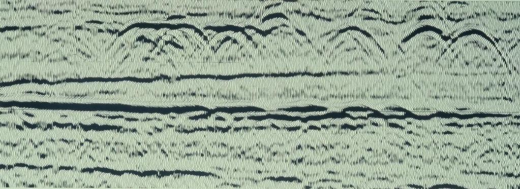
21 Magnus HR Multichannel Data 1984 Vintage 21
22 Remit Drivers: Operational Life Cycle Access Exploration Drilling / Well Activity Appraisal Development Production Abandon 22
23 Drivers for Integrated Study Scope Scale and Complexity Available Technologies Geophysical technology take-up in the round Delivery Across the Life of License 23
24 Geohazard Risk Fundamentals set. Exploration phase data needs set. Licence wide Baseline Assessment 1st Pass Geohazard Risk Source Definition. 1st Well Location Assessment Top-Hole Witness / Verification Appraisal Well Location Specific Assessment Geohazard Risk Source Definition revisited. Development Phase data needs set. Development Phase studies set to address Geohazard Risk Sources. Specific Geohazard element studies Integrated Development Overburden Model completed. Quantitative Risk Assessment areas identified. Quantitative Risk Assessment completed and included in Project Risk Register for mitigation Incident Response Subsurface data monitoring plan Update Integrated Geological Model Update Drilling Location Assessment for drilling renewal Identify data renewal / update requirements. Update Integrated Geological Model for Extended Field Life or Field Redevelopment Assess possibility of Overburden and / or well integrity issues. Update Drilling Location Assessment Assess abandonment geohazard implications Example Geohazards Lifecycle Access Exploration Appraisal Development Drilling / Well Activity Well Location Site (Re)Assessment And/ Top-Hole Witness Production Abandon Example Geohazards Life Cycle
25 Update Schedule (Originally updated 2012), Automatic scheduled review about to start Sub-Committee Members have submitted issues to be addressed Presenter has visited Ministry in Trinidad and Tobago, BOEM in GoM USA and will visit EGAS in Cairo in two weeks time to gather comments Input and comment from all OGP members would be welcomed Some feedback already received highlights need to tighten up wording e.g. Requirements vs. Guidance Technology moves on: acquisition and processing capability (Published October 2015) No scheduled update for two years. 25
26 3D Data Usage This is an area that has limits that are changing constantly Five years ago OBC and OBN surveys would not have been considered for use in or support of Site Investigation Mirror migration has changed this In Deep Water however use of 3D has become very much a standard approach around the world with few provisos Advent of Broadband seismic solutions is making this approach even more valid Careful processing is making even WATS data usable for geohazards screening 26

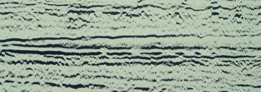
27 1995 2DHR Dip Line SE of Central Azeri Seismic Amplitude + 200ms TWT m 27

28 2012 3DHR Dip Line SE of Central Azeri Seismic Amplitude + 200ms TWT m 28

29 200ms TWT Imaging: 2DHR vs. OBC upgoing wavefield 2DHR Up-going OBC 3D Poor/no shallow coverage Poor fault imaging Poor channel imaging Out of plane energy Severe seismic blanking beneath gas Low vertical resolution Amplitude 500m

30 200ms TWT Imaging: 2DHR vs. OBC downgoing wavefield 2DHR Down-going OBC 3D Poor fault imaging Complete shallow coverage Sharp fault imaging Poor channel imaging Good channel imaging Out of plane energy Severe seismic blanking beneath gas Improved vertical resolution Image beneath shallow gas Amplitude 500m
31 Broadband Seismic Technology 31


32 WATS 3D Data Processed for Shallow Imaging 3D WATS - Original 3D - WATS Reprocessed for Geohazards 32
33 Update Schedule (Originally updated 2012) Input and comment from all OGP members would be welcomed (Published October 2015) No scheduled update for two years. Download the Documents from or via direct links below: Formal Questions or Comments: Lucyna Kryla-Straszewska: Andy W Hill: hillaw@bp.com 33
Site Investigations for Offshore Wind
 Site Investigations for Offshore Wind A multi-disciplinary approach Mattijs de Lange Gardline Marine Sciences Limited My thanks to: Maarten Timmerman David Cerda Saltzman Sue Crothers Albert van der Hem
Geophysical Site Surveys
 Geophysical Site Surveys Simon Oakley Geoscience Team Leader Fugro Survey Limited 16/04/2014 Contents Menu Introduction Section 1 - Geophysical Site Surveys - Seabed Bathymetry - Shallow Geology - Seabed
Offshore Operations and Project Execution Geophysical Site Surveys
 Offshore Operations and Project Execution Geophysical Site Surveys Chris Almond Senior Geophysicist Fugro Survey Limited 22/04/2015 Presentation Summary: Office-based Personnel Project Awarded Pre Offshore
Guidelines for the conduct of offshore drilling hazard site surveys
 Guidelines for the conduct of offshore drilling hazard site surveys Report No. 373-18-1 April 2011 International Association of Oil & Gas Producers P ublications Global experience The International Association
From PZ summation to wavefield separation, mirror imaging and up-down deconvolution: the evolution of ocean-bottom seismic data processing
 From PZ summation to wavefield separation, mirror imaging and up-down deconvolution: the evolution of ocean-bottom seismic data processing Sergio Grion, CGGVeritas Summary This paper discusses present
P2061 Relinquishment Report
 Document last updated 23-07-2015 12:28 CEST 1 Licence Information 1 2 Licence Synopsis 2 3 Work Program 4 4 Database 8 4.1 Seismic 8 4.2 Gravity and Magnetics 10 5 Prospectivity Update 12 6 Resource and
Hydrofest The Hydrographic Society in Scotland
 Hydrofest 2017 The Hydrographic Society in Scotland Offshore Survey in the Oil and Gas Industry Hydrofest 2017 Chris Leaf Head Offshore Surveys Shell Projects and Technology, Europe Presentation Overview
"Our Profession: Today and the Next Ten FiveYears" Jack Verouden Outgoing Chairman OGP Surveying & Positioning Committee
 "Our Profession: Today and the Next Ten FiveYears" Jack Verouden Outgoing Chairman OGP Surveying & Positioning Committee and Shell Chief Surveyor Greenwich Meridian 112 m No error in Google Earth: Different
FOUNDATIONS FOR OFFSHORE STRUCTURES
 FOUNDATIONS FOR OFFSHORE STRUCTURES DELHI CHAPTER Pradeep Hora It takes less time to do a thing right than explain why you did it wrong. - Henry Wadsworth Longfellow 2 1 Site Investigations (Survey) What
Downloaded 09/10/15 to Redistribution subject to SEG license or copyright; see Terms of Use at
 The role of legacy seismic in exploring new offshore hydrocarbon provinces or can you teach old data new tricks (technologies)? Howard Nicholls, Lauren Penn, Anna Marszalek, Paolo Esestime, Karyna Rodriguez,
TATA CHEMICALS MAGADI LIMITED (Mining Section) TRONA CRUSHING PLANT AND PREWASH TANK FACILITY PROJECT
 TRONA CRUSHING PLANT AND PREWASH TANK FACILITY PROJECT") 1 TATA CHEMICALS MAGADI LIMITED (Mining Section) TRONA CRUSHING PLANT AND PREWASH TANK FACILITY PROJECT RFQ for Geotechnical Investigations and Foundation Recommendations TCML/MS/RFQ1/2017 October 2017
1 TATA CHEMICALS MAGADI LIMITED (Mining Section) TRONA CRUSHING PLANT AND PREWASH TANK FACILITY PROJECT RFQ for Geotechnical Investigations and Foundation Recommendations TCML/MS/RFQ1/2017 October 2017
OFFSHORE SURVEY IN THE OIL & GAS INDUSTRY WHAT S THAT ALL ABOUT? Ian Douglas Head, Offshore Surveys, Shell Projects & Technology Europe
 OFFSHORE SURVEY IN THE OIL & GAS INDUSTRY WHAT S THAT ALL ABOUT? Ian Douglas Head, Offshore Surveys, Shell Projects & Technology Europe Hydrofest 2014 13 March 2014 1 Why Position Matters The Exploration
Relinquishment Report. Licence P1616. Block 21/12b
 Relinquishment Report Licence P1616 Block 21/12b EOG Resources United Kingdom Limited March 2014 List of Contents 1. Licence information 2. Licence Synopsis 3. Work Programme Summary 4. Database 5. Further
E014 4D Case Study at Ringhorne, Ringhorne East, Balder and Forseti - Integrating OBC with Streamer Data
 E014 4D Case Study at Ringhorne, Ringhorne East, Balder and Forseti - Integrating OBC with Streamer Data M.B. Helgerud* (ExxonMobil E&P), U.K. Tiwari (ExxonMobil E&P), S.G. Woods (ExxonMobil E&P), P. Homonko
An Overview of Geomatics Involvement in the Offshore Oil & Gas Industry
 An Overview of Geomatics Involvement in the Offshore Oil & Gas Industry David Whitcombe Head Offshore Surveys - Europe Explore Appraise Develop ProduceDecommission Content Overview Oil & Gas Industry Geomatics
Developing the Arundel Field Maximising Hub Value through Seismic Uplift. Chris Hill CNS Geophysicist, BP
 Developing the Arundel Field Maximising Hub Value through Seismic Uplift Chris Hill CNS Geophysicist, BP Arundel Area Introduction Lista Palaeocene Turbidite reservoirs Sands are high productivity with
UK P2060, Block 29/06b Licence Relinquishment
 ENDEAVOUR ENERGY UK LIMITED UK P2060, Block 29/06b Licence Relinquishment ISSUE RECORD SUMMARY Dec 2015 Final Graham Tegerdine Rev Date Description Document Owner Review Required By Table of Contents 1
Downloaded 11/20/12 to Redistribution subject to SEG license or copyright; see Terms of Use at
 AVO crossplot analysis in unconsolidated sediments containing gas hydrate and free gas: Green Canyon 955, Gulf of Mexico Zijian Zhang* 1, Daniel R. McConnell 1, De-hua Han 2 1 Fugro GeoConsulting, Inc.,
Exploitation of Ocean Predictions by the Oil and Gas Industry. GODAE OceanView Symposium 2013
 Exploitation of Ocean Predictions by the Oil and Gas Industry GODAE OceanView Symposium 2013 Introduction Information needs Challenges Acknowledgements IMarEST/SUT Metocean Awareness Course Colleagues
Using high-density OBC seismic data to optimize the Andrew satellites development
 Using high-density OBC seismic data to optimize the Andrew satellites development Leendert Padmos, 1* Daniel Davies, 1 Merv Davies 1 and John McGarrity 1 Abstract The processed data from conventional towed-streamer
June 2014 RELINQUISHMENT REPORT LICENCE P1454
 June 2014 RELINQUISHMENT REPORT LICENCE P1454 Relinquishment Report Licence P1454, Block 208/11 and 214/15 1. Licence Information Licence number P1454 (Figure 1) Licencing Round 24th First Term Awarded
FloatSeis Technologies for Ultra-Deep Imaging Seismic Surveys
 FloatSeis Technologies for Ultra-Deep Imaging Seismic Surveys 25 th January, 2018 Aleksandr Nikitin a.nikitin@gwl-geo.com Geology Without Limits Overview 2011-2016 GWL Acquired over 43000 km 2D seismic
Offshore geo-hazards to keep in mind during prospecting and exploration activities of the Jan Mayen Micro- Continent area.
 Offshore geo-hazards to keep in mind during prospecting and exploration activities of the Jan Mayen Micro- Continent area. Anett Blischke, Iceland GeoSurvey Þórarinn S. Arnarson, of Iceland Bjarni Richter,
OBS wavefield separation and its applications
 P-088 OBS wavefield separation and its applications Sergio Grion*, CGGVeritas Summary This paper discusses present trends in ocean-bottom seismic (OBS) data processing. Current industrial practices for
P-Cable UHR3D Seismic What is it, and when is it better? Presented by: Brian Brookshire, NCS SubSea By Invitation of: SUT Houston's Offshore Site
 P-Cable UHR3D Seismic What is it, and when is it better? Presented by: Brian Brookshire, NCS SubSea By Invitation of: SUT Houston's Offshore Site Investigation and Geotechnics Committee Contents What is
Gigante: the first step to getting a comprehensive view of the Gulf of Mexico. Chris Corona Alex Birch-Hawkins September 17, 2015
 Gigante: the first step to getting a comprehensive view of the Gulf of Mexico Chris Corona Alex Birch-Hawkins September 17, 2015 2015 TGS-NOPEC Geophysical Company ASA. All rights reserved. 2 Discussion
P Edward Knight 1, James Raffle 2, Sian Davies 2, Henna Selby 2, Emma Evans 2, Mark Johnson 1. Abstract
 P1-3-10 De-risking Drill Decisions. A case study on the benefit of re-processing conventionally acquired seismic data with the latest broadband processing technology Edward Knight 1, James Raffle 2, Sian
Seismic Guided Drilling: Near Real Time 3D Updating of Subsurface Images and Pore Pressure Model
 IPTC 16575 Seismic Guided Drilling: Near Real Time 3D Updating of Subsurface Images and Pore Pressure Model Chuck Peng, John Dai and Sherman Yang, Schlumberger WesternGeco Copyright 2013, International
Optimizing seismic repeatability at Ringhorne, Ringhorne East, Balder and Forseti with QC driven time-lapse processing
 with QC driven time-lapse processing Michael B Helgerud, Upendra Tiwari, Stephen Woods (ExxonMobil Exploration Company) Peter Homonko (ExxonMobil International Limited) Adam Bucki and Bernard Laugier (ExxonMobil
HORDA SURVEY HERALDS NEW STRATEGY
 HORDA SURVEY HERALDS NEW STRATEGY CGG sets sights on multi-client market leadership in Norway BY IDAR HORSTAD, ERLING FRANTZEN AND JO FIRTH, CGG 12 seismic profile Figure 1: Reprocessing of the Cornerstone
P1846 Relinquishment Report
 Document last updated 23-07-2015 12:32 CEST 1 Licence Information 1 2 Licence Synopsis 2 3 Work Program 4 3.1 Seismic Reprocessing 4 4 Database 7 4.1 Seismic 7 4.2 Gravity and Magnetics 9 5 Prospectivity
Key findings of the CPR:
 New World Oil and Gas Plc / Index: AIM / Epic: NEW / Sector: Oil & Gas 16 August 2011 New World Oil and Gas Plc ( New World or the Company ) Prospectivity of the Danica Jutland Project, Denmark, highlighted
Geohazards have a direct impact on the drilling and
 SPECIAL Geohazards SECTION: G e o h a z a r d s A new, fully integrated method for seismic geohazard prediction ahead of the bit while drilling CENGIZ ESMERSOY, ARTURO RAMIREZ, SHARON TEEBENNY, YANGJUN
Time vs depth in a North Sea case study of the ugly truth Abstract
 Time vs depth in a North Sea case study of the ugly truth Thomas Massip 1, Lauren Braidwood 1, Juergen Fruehn 1, Owen Isaac 1, Jonathan Denly 1, Robert Richardson 2, Phil Mollicone 3 1 ION Geophysical;
GEOPHYSICAL SURVEYS: What are Seismic Surveys and How are They Done?
 GEOPHYSICAL SURVEYS: What are Seismic Surveys and How are They Done? Marine Geophysical Exploration Purpose Image the subsurface Evaluate the acreage Identify potential hydrocarbon accumulations Reducing
Detection, Delineation and Characterization of Shallow Anomalies Using Dual Sensor Seismic and Towed Streamer EM data
 Detection, Delineation and Characterization of Shallow Anomalies Using Dual Sensor Seismic and Towed Streamer EM data A.J. McKay* (Petroleum Geo-Services ASA), M. Widmaier (Petroleum Geo- Services ASA),
Summary. Introduction
 The practicability of reservoir monitoring with true 4D surface seismic data Adeyemi Arogunmati* and Jerry M. Harris, Stanford University, California, USA Summary Harris et al., (2007) proposed a strategy,
Petroleum Exploration
 Petroleum Exploration Upstream Petroleum Exploration The role of exploration is to provide the information required to exploit the best opportunities presented in the choice of areas, and to manage research
Overview of Engineering. Risk Management for Successful Wind Energy Development, Offshore U.S.
 Overview of Engineering Considerations for Siting and Risk Management for Successful Wind Energy Development, Offshore U.S. Bi Briefing for: North Carolina Offshore Wind Task Force Tom McNeilan, P.E. General
Microseismicity applications in hydraulic fracturing monitoring
 Available online atwww.scholarsresearchlibrary.com Archives of Applied Science Research, 2016, 8 (4):13-19 (http://scholarsresearchlibrary.com/archive.html) ISSN 0975-508X CODEN (USA) AASRC9 Microseismicity
G002 An Integrated Regional Framework for Seismic Depth Imaging in the Deepwater Gulf of Mexico
 G002 An Integrated Regional Framework for Seismic Depth Imaging in the Deepwater Gulf of Mexico M. Davidson (Fugro Multi Client Services), M. Leander (Fugro Multi Client Services), K. Mohn (Fugro Multi
Common Exploration Methods.
 Common Exploration Methods. The following list contains the most common methods which a company with a mineral prospecting licence in Northern Ireland might use to carry out a mineral prospecting programme.
Tu N Fault Shadow Removal over Timor Trough Using Broadband Seismic, FWI and Fault Constrained Tomography
 Tu N118 05 Fault Shadow Removal over Timor Trough Using Broadband Seismic, FWI and Fault Constrained Tomography Y. Guo* (CGG), M. Fujimoto (INPEX), S. Wu (CGG) & Y. Sasaki (INPEX) SUMMARY Thrust-complex
Geophysical Applications Seismic Reflection Processing
 Seismic reflection data are routinely acquired for multiple purposes such as exploration, mining, or engineering problems. The seismic data are generally acquired in shot-gathers, i.e. the data is sorted
RELINQUISHMENT REPORT FOR LICENCE P.1663, BLOCK 29/4b and 29/5e
 RELINQUISHMENT REPORT FOR LICENCE P.1663, BLOCK 29/4b and 29/5e Licence: P.1663 Blocks: 29/4b & 29/5e 25th Round Traditional Licence Operator: Ithaca Energy UK(Ltd) 100% Work Programme Summary The agreed
Identified a possible new offset location where the customer is currently exploring drill options.
 GroundMetrics was hired to conduct a Full-Field Resistivity Survey for an oil and gas producer that needed to make crucial decisions to drive profitability at the location. The results saved them hundreds
NEW SEAFLOOR INSTALLATIONS REQUIRE ULTRA-HIGH RESOLUTION SURVEYS
 NEW SEAFLOOR INSTALLATIONS REQUIRE ULTRA-HIGH RESOLUTION SURVEYS Donald Hussong (Fugro Seafloor Surveys, Inc.) dhussong@fugro.com Fugro Seafloor Surveys, Inc., 1100 Dexter Avenue North (Suite 100), Seattle,
We A10 12 Common Reflection Angle Migration Revealing the Complex Deformation Structure beneath Forearc Basin in the Nankai Trough
 We A10 12 Common Reflection Angle Migration Revealing the Complex Deformation Structure beneath Forearc Basin in the Nankai Trough K. Shiraishi* (JAMSTEC), M. Robb (Emerson Paradigm), K. Hosgood (Emerson
The Ruru discovery. New Zealand Petroleum Conference Roland Swift Ruru Technical Lead. NZ Petroleum Conference 2017
 The Ruru discovery New Zealand Petroleum Conference 2017 Roland Swift Ruru Technical Lead NZ Petroleum Conference 2017 March 2017 1 The Ruru discovery 1. Introduction 2. 2013-2014 Operations 3. Results
Model Building Complexity in the Presence of a Rugose Water Bottom Gippsland Basin Australia
 Model Building Complexity in the Presence of a Rugose Water Bottom Gippsland Basin Australia Paul Bouloudas, Apache Energy, Juergen Fruehn, ION GX Technology Introduction Situated offshore south-eastern
COMMUNITY DEVELOPMENT DEPARTMENT POLICY & PROCEDURE
 COMMUNITY DEVELOPMENT DEPARTMENT POLICY & PROCEDURE Policy No: DSP-OO3 Release Date: January 1, 2014 Effective Date: January 1, 2014 Revision Date: March 1, 2018 TITLE: The City Policy for Site Specific
Exploration Well Failures from the Moray Firth & Central North Sea (UK) 21 st Century Exploration Road Map Project Christian Mathieu
 21 st Century Exploration Road Map Project Christian Mathieu") Exploration Well Failures from the Moray Firth & Central North Sea (UK) 21 st Century Exploration Road Map Project Christian Mathieu 1. Project Objectives, Time-Line and Status 2. A few statistics 3. Reasons
Exploration Well Failures from the Moray Firth & Central North Sea (UK) 21 st Century Exploration Road Map Project Christian Mathieu 1. Project Objectives, Time-Line and Status 2. A few statistics 3. Reasons
P1794 Relinquishment Document Blocks 22/2d, 22/3c & 22/4c
 P1794 Relinquishment Document Blocks 22/2d, 22/3c & 22/4c 1. Licence Information Licence Number: P1794 Licence Round: 26 th Round- Awarded January 2011 Licence Type: Traditional; (Drill or Drop within
IPTC PP Challenges in Shallow Water CSEM Surveying: A Case History from Southeast Asia
 IPTC-11511-PP Challenges in Shallow Water CSEM Surveying: A Case History from Southeast Asia Sandeep K. Chandola*, Rashidah Karim, Amy Mawarni, Russikin Ismail, Noreehan Shahud, Ramlee Rahman, Paul Bernabe
Deep-Water Reservoir Potential in Frontier Basins Offshore Namibia Using Broadband 3D Seismic
 Deep-Water Reservoir Potential in Frontier Basins Offshore Namibia Using Broadband 3D Seismic E. Polyaeva* (Petroleum Geo-Services), I. Thomas (Chariot Oil and Gas), C. Reiser (Petroleum Geo-Services),
Imaging complex structure with crosswell seismic in Jianghan oil field
 INTERPRETER S CORNER Coordinated by Rebecca B. Latimer Imaging complex structure with crosswell seismic in Jianghan oil field QICHENG DONG and BRUCE MARION, Z-Seis, Houston, Texas, U.S. JEFF MEYER, Fusion
Tan K. Wang National Taiwan Ocean University, Keelung, Taiwan, R.O.C.
 SEISMIC IMAGING IN THE OCEANS Tan K. Wang National Taiwan Ocean University, Keelung, Taiwan, R.O.C. Keywords: Converted wave, multi-channel seismic, ocean-bottom seismometer, travel-time inversion, virtual
UK Onshore Licence PEDL 153 Relinquishment Report September 2010
 UK Onshore Licence PEDL 153 September 2010 Licence Details Licence Number : PEDL 153 Licence Round : UK 12 th Onshore Licensing Round Effective Date: 1 October 2004 Licence Type : Petroleum Exploration
High Resolution Seismic for Minerals
 High Resolution Seismic for Minerals Greg Turner HiSeis Pty Ltd MEGWA April 2013 WELCOME HiSeis Pty Ltd, Suite 4 Enterprise Unit 3, 9 DeLaeter Way, Bentley, WA 6102 Ph: +61 8 9470 9866 www.hiseis.com Used
COVER STORY LUKE TWIGGER, CGG, UK, EXAMINES RECENT ADVANCES IN SEISMIC TECHNOLOGY THAT REDUCE SUBSALT RISK.
 COVER STORY LUKE TWIGGER, CGG, UK, EXAMINES RECENT ADVANCES IN SEISMIC TECHNOLOGY THAT REDUCE SUBSALT RISK. O il and gas exploration, especially in areas of complex geology such as salt provinces, is a
Gas Hydrate as a Resource - Statoil s Hydrate Initiative
 Gas Hydrate as a Resource - Statoil s Hydrate Initiative Thomas Reichel & Jarle Husebø Exploration Global New Ventures / R&D Explore Unconventionals 1 - Outline Gas hydrate occurances & resource potential
9 Exploration operations
 9 Exploration operations Seismic surveys Exploration drilling New discoveries Future exploration North Sea Norwegian Sea Barents Sea 60 50 Wildcats Appraisals 40 30 Wells 20 10 0 66 68 70 72 74 76 78 80
Imaging Deep into the Gulf of
 TECHNOLOGY EXPLAINED Imaging Deep into the Gulf of Houston Houston The Gulf of Mexico as viewed from space. This Mediterraneantype sea is located at the southeastern corner of North America. It covers
Hydrocarbon Trap Classification Based on Associated Gas Chimneys
 Chapter 14 Hydrocarbon Trap Classification Based on Associated Gas Chimneys Roar Heggland 1 Abstract Oil seeps, shallow gas, and surface features such as seabed pockmarks and mud volcanoes are historically
Vertical and horizontal resolution considerations for a joint 3D CSEM and MT inversion
 Antony PRICE*, Total E&P and Don WATTS, WesternGeco Electromagnetics Summary To further explore the potential data content and inherent limitations of a detailed 3D Controlled Source ElectroMagnetic and
PETROLEUM 101. Mark Shrimpton Jacques Whitford
 PETROLEUM 101 Mark Shrimpton Jacques Whitford PRESENTATION STRUCTURE The Offshore Petroleum Industry Petroleum Geology Petroleum Technology: Exploration agreements Geophysical exploration Drilling Development
Velocity Update Using High Resolution Tomography in Santos Basin, Brazil Lingli Hu and Jianhang Zhou, CGGVeritas
 Lingli Hu and Jianhang Zhou, CGGVeritas Summary The exploration interest in the Santos Basin offshore Brazil has increased with the large deep water pre-salt discoveries, such as Tupi and Jupiter. As the
Ardent Oil Limited. Relinquishment report. Promote Licence P1953. Blocks 22/24h. March 2015
 Ardent Oil Limited Relinquishment report Promote Licence P1953 Blocks 22/24h March 2015 Licence P1953 Block 22/24h Relinq report Page 1 of 9 Ardent Oil Limited Relinquishment report for Block 22/24h 1.0
Outlook for Major Segments of the International Offshore Industry Geology and Geophysical
 2015-2017 Outlook for Major Segments of the International Offshore Industry Geology and Geophysical Dave Ridyard SVP Business Development ION Geophysical 38th ANNUAL MARINE/OFFSHORE INDUSTRY OUTLOOK CONFERENCE
Hague and London Oil Plc
 Hague and London Oil Plc Exploiting Shallow Gas Offshore Netherlands De-Gassing Shallow Hazards or De-Risking Shallow Gas November 2016 The Shallow Gas Play can be Summarized as Schematic evolution of
COMMENT CARD RESPONSES (SEISMIC)
") COMMENT CARD 1 1. Please explain once and for all why the original route isn t an option while it s safer and cheaper, instead of going under the high school? Response: Please refer to the November Community
COMMENT CARD 1 1. Please explain once and for all why the original route isn t an option while it s safer and cheaper, instead of going under the high school? Response: Please refer to the November Community
Susitna-Watana Hydroelectric Project (FERC No ) Site-Specific Seismic Hazard Study Study Plan Section 16.6
 Site-Specific Seismic Hazard Study Study Plan Section 16.6") (FERC No. 14241) Site-Specific Seismic Hazard Study Study Plan Section 16.6 Initial Study Report Part A: Sections 1-6, 8-9 Prepared for Prepared by MWH / Fugro June 2014 TABLE OF CONTENTS 1. Introduction...
(FERC No. 14241) Site-Specific Seismic Hazard Study Study Plan Section 16.6 Initial Study Report Part A: Sections 1-6, 8-9 Prepared for Prepared by MWH / Fugro June 2014 TABLE OF CONTENTS 1. Introduction...
Outline National legislative & policy context Regional history with ESSIM ESSIM Evaluation Phase Government Integration via RCCOM Regional ICOM Framew
 What MSP Implementation could change in the Maritimes Region Tim Hall, Regional Manager Oceans and Coastal Management Division Ecosystem Management Branch Fisheries and Oceans Canada Maritimes Region BIO
Impact of Noise on the Marine Environment a Regulatory Perspective
 Impact of Noise on the Marine Environment a Regulatory Perspective John Hartley Hartley Anderson Ltd. Photographs courtesy of JNCC Over-arching Objective Minimise the Impact of Oil and Gas Activities &
Improved Exploration, Appraisal and Production Monitoring with Multi-Transient EM Solutions
 Improved Exploration, Appraisal and Production Monitoring with Multi-Transient EM Solutions Folke Engelmark* PGS Multi-Transient EM, Asia-Pacific, Singapore folke.engelmark@pgs.com Summary Successful as
TAKING THE MYSTERY OUT OF USACE S ER DRILLING IN EARTH EMBANKMENT DAMS AND LEVEES
 TAKING THE MYSTERY OUT OF USACE S ER 1110-1-1807 DRILLING IN EARTH EMBANKMENT DAMS AND LEVEES 237 237 237 217 217 217 200 200 200 80 119 27 252 174.59 1 255 255 255 0 0 0 163 163 163 131 132 122 239 65
Update on the seismic evaluation of the plans for Shaft #4 in the Cayuga Salt Mine, New York State April 11, 2017
 Update on the seismic evaluation of the plans for Shaft #4 in the Cayuga Salt Mine, New York State April 11, 2017 Authored by Angus Ferguson and John Warren 1 xecutive Summary There is now multiple public-domain
Revisions to Text Based on Completion of Tier III Validation. Section 1. Section 4.2
 Revisions to Text Based on Completion of Tier III Validation Section 1 Section 4.2 Downstream Areas Data Assessment Report Revision 2 1. Introduction ARCADIS U.S., Inc. (ARCADIS) has prepared this Downstream
Introduction AGR AVO Figure 1 (a) (b)
 (b)") Introduction In order to ensure the safety of its drilling operations while developing an important gas field in South East Asia, Total performed a large project of Shallow Gas Hazard identification with
Introduction In order to ensure the safety of its drilling operations while developing an important gas field in South East Asia, Total performed a large project of Shallow Gas Hazard identification with
Shear wave statics in 3D-3C : An alternate approach
 P-157 C. B. Yadava*, M Singh, Kuldeep Prakash, Kunal Niyogi GEOPIC, Oil & Natural Gas Corporation Ltd, Dehradun Summary 3D-3C data was acquired in Sayan-Tadkeshwar area of Cambay basin to bring out sand
City of Manitou Springs
 March 2018 City of Manitou Springs Implementing Land Use tools to reduce and mitigate natural hazard risk Context & History Past Present Historic homes Older infrastructure Hillside development Creekside
Towed Streamer EM Integrated interpretation for accurate characterization of the sub-surface. PETEX, Tuesday 15th of November 2016
 Towed Streamer EM Integrated interpretation for accurate characterization of the sub-surface. PETEX, Tuesday 15th of November 2016 Joshua May Sales and Marketing Manager Agenda Introduction to Towed Streamer
All permissions to publish have been obtained (see Section 9)
") 1. Licence Information Licence Number: P1741 Licence Round: 26 th Round Licence Type: Traditional Block Numbers: 42/13b, 42/17 & 42/18 All permissions to publish have been obtained (see Section 9) 2. Licence
1. Licence Information Licence Number: P1741 Licence Round: 26 th Round Licence Type: Traditional Block Numbers: 42/13b, 42/17 & 42/18 All permissions to publish have been obtained (see Section 9) 2. Licence
CO2 Storage- Project list
 a) NGI involvement with CO 2 storage field sites, pilots and demos 1. In Salah CO2 storage In Salah is located in Krechba, central Algeria. Injection of CO 2 started in 2004 and halted in 2011. A total
Monitoring of CO2 Leakage Using High-Resolution 3D Seismic Data Examples from Snøhvit, Vestnesa Ridge and the Western Barents Sea
 Monitoring of CO2 Leakage Using High-Resolution 3D Seismic Data Examples from Snøhvit, Vestnesa Ridge and the Western Barents Sea Bellwald, B. 1, Waage, M. 2, Planke, S. 1,3,4, Lebedeva-Ivanova, N. 1,
Relinquishment Report for Exploration License P.1749
 Part Block 49/24c Oranje-Nassau Energie B.V. UN Studio, 7 th floor Parnassusweg 815 1082 LZ, Amsterdam The Netherlands Date: Report No.: Issue No.: 12 September 2016 20160602-RL1 Document Control Prepared:
RECOMMENDED PRACTICE FOR SITE SPECIFIC ASSESSMENT OF MOBILE JACK-UP UNITS
 RECOMMENDED PRACTICE FOR SITE SPECIFIC ASSESSMENT OF MOBILE JACK-UP UNITS GULF OF MEXICO ANNEX Revision 0 September 2007 Rev Issue Date Details 0 September 2007 Submitted to SNAME OC7 for Adoption Introduction:
Downloaded 09/16/16 to Redistribution subject to SEG license or copyright; see Terms of Use at
 Data Using a Facies Based Bayesian Seismic Inversion, Forties Field, UKCS Kester Waters* (Ikon Science Ltd), Ana Somoza (Ikon Science Ltd), Grant Byerley (Apache Corp), Phil Rose (Apache UK) Summary The
Z046 Seismic Characteristics of Gas Migration Structures on the North Atlantic Margin Imaged by High-resolution 3D Seismic
 Z046 Seismic Characteristics of Gas Migration Structures on the North Atlantic Margin Imaged by High-resolution 3D Seismic O.K. Eriksen* (P-Cable 3D Seismic), C. Berndt (IFM-GEOMAR), S. Buenz (University
Measurement, Monitoring and Verification (MMV)
") Measurement, Monitoring and Verification (MMV) Larry Myer USCSC CCS Capacity Building Workshop Charleston, West Virginia October 25, 2011 Outline Why monitor? Information needs Monitoring methods Baselines
Measurement, Monitoring and Verification (MMV) Larry Myer USCSC CCS Capacity Building Workshop Charleston, West Virginia October 25, 2011 Outline Why monitor? Information needs Monitoring methods Baselines
APPLICATION FOR AUTHORITY TO DRILL A WELL (ADW)
") APPLICATION FOR AUTHORITY TO DRILL A WELL (ADW) Operator: Pursuant to section 8 and 9 of the Petroleum and Natural Gas Act (R.S.N.L. 1990, c. P-10) and in compliance with section 29 of the Petroleum Drilling
APPLICATION FOR AUTHORITY TO DRILL A WELL (ADW) Operator: Pursuant to section 8 and 9 of the Petroleum and Natural Gas Act (R.S.N.L. 1990, c. P-10) and in compliance with section 29 of the Petroleum Drilling
P1488 DECC Relinquishment Report OMV (U.K.) Ltd.
 Ltd.") 1. Synopsis: P1488 DECC Relinquishment Report OMV (U.K.) Ltd. UK offshore Licence P1488 was awarded to OMV, Dana Petroleum and Rocksource in the 24 th Licence Round on the 24 th of January 2007 as a frontier
1. Synopsis: P1488 DECC Relinquishment Report OMV (U.K.) Ltd. UK offshore Licence P1488 was awarded to OMV, Dana Petroleum and Rocksource in the 24 th Licence Round on the 24 th of January 2007 as a frontier
J.A. Haugen* (StatoilHydro ASA), J. Mispel (StatoilHydro ASA) & B. Arntsen (NTNU)
, J. Mispel (StatoilHydro ASA) & B. Arntsen (NTNU)") U008 Seismic Imaging Below "Dirty" Salt J.A. Haugen* (StatoilHydro ASA), J. Mispel (StatoilHydro ASA) & B. Arntsen (NTNU) SUMMARY Base and sub salt seismic imaging is still an unresolved issue. To solve
U008 Seismic Imaging Below "Dirty" Salt J.A. Haugen* (StatoilHydro ASA), J. Mispel (StatoilHydro ASA) & B. Arntsen (NTNU) SUMMARY Base and sub salt seismic imaging is still an unresolved issue. To solve
Potentials for Mineral and Hydrocarbon Development in the Northern part of Greenland
 Potentials for Mineral and Hydrocarbon Development in the Northern part of Greenland WWF Seminar Iqaluit, 4-5 June 2013 Maja Sofie Burgaard Bureau of Minerals and Petroleum Agenda The Greenland Government
Relinquishment Report for Licence Number P1356, Block 48/8c March 2008
 Relinquishment Report for Licence Number P1356, Block 48/8c March 2008 Table of Contents 1.0 Header...3 2.0 Synopsis...3 3.0 Exploration Activities...4 4.0 Prospectivity Analysis...11 5.0 Conclusions...12
Relinquishment Report
 Relinquishment Report Licence P1403 Block 13/22d Chevron North Sea Limited Korean National Oil Company Chevron North Sea Limited December 2009 1 SYNOPSIS... 3 2 INTRODUCTION. 3 2.1 Licence Terms.. 3 2.2
TABLE 1 SSFL CHEMICAL SOIL BACKGROUND STUDY DATA QUALITY OBJECTIVES
 Problem Statement: Soil chemical concentration data for selected constituents are needed from off-site chemical background reference areas (CBRAs) to establish a regulatory-compliant, publicly-reviewed,
Storage: Deep Monitoring and Verification
 Storage: Deep Monitoring and Verification IEA GHG Summer School, Austin, TX David White 7 th to 11 th July, 2014 www.slb.com/carbonservices CS1406-063-DW Why Monitor? Manage Risk Risk = (Impact of Undesirable
Marine Geophysical Methods: What Can and Cannot Be Done to Iden8fy Hazards to Dredging & Marine Construc8on
 Marine Geophysical Methods: What Can and Cannot Be Done to Iden8fy Hazards to Dredging & Marine Construc8on Marine Geophysics Sham or Savior? Seen alternatively as the silver bullet or snake oil, marine