Imaging Deep into the Gulf of
|
|
|
- Cleopatra Holland
- 5 years ago
- Views:
Transcription
1


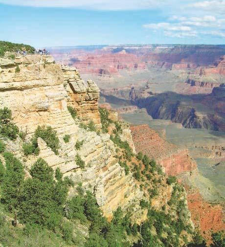
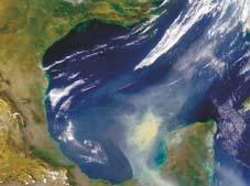
2 TECHNOLOGY EXPLAINED Imaging Deep into the Gulf of Houston Houston The Gulf of Mexico as viewed from space. This Mediterraneantype sea is located at the southeastern corner of North America. It covers 1.5 million square kilometers and has an average water depth of about 1600 m. What lies below the water surface is what is important to the United State s energy supply and to the oil and gas companies exploring this region. Photo: NASA/GSFC Aceca 2 Extract GEO ExPro January 2007


3 Mexico Recent deep gas and deep-water discoveries in the Gulf of Mexico are pushing exploration technology to the limit. In many ways, the future success will depend on the ability of the geophysical industry to address the technical challenges offered by deeper and more obscured geologic targets. YUCATAN Photo: Jacuqes Descioitres, NASA/GSFC TGS Recently, we have seen wells drilled to more than 9000m, and in several cases wells were drilled 3000m or more after drilling through more than 3000m of salt. This is not your father s exploration program! says Kim Abdallah, TGS VP NSA New Ventures. Extract GEO ExPro January


4 TECHNOLOGY EXPLAINED TGS TGS TGS Offset Acquisition Seismic acquisition using a towed hydrophone array and towed energy source. OBC-Type A Seismic acquisition using a 4-component cable positioned on the sea bed and a towed energy source. The data is recorded on board the recording vessel. OBC-Type B Seismic Acquisition using a 4-component cable positioned on the sea bed and a towed energy source. The data is recorded in float buoys and retrieved periodically. Thomas Smith, Associate Editor It is no secret that it is becoming more and more of a challenge to meet the expected production increases in the Gulf of Mexico. With its incredible potential, the much touted deep gas shelf play seems to be just out of reach of today s drilling technology. For elephant hunting, the deepwater areas continue to receive the most attention. This has been aided by recent announcements of 12 deep-water discoveries and the emergence of the deep-water Lower Tertiary Wilcox trend. Data Acquisition Challenges The Gulf of Mexico has long been a proving ground for exploration technology. Few areas in the world offer the multiple geologic challenges of the Gulf of Mexico (GEO ExPro, No. 4/5, 2006; com). Potential hydrocarbon traps can be hidden by salt, gas clouds, multiples and water bottom issues (statics), to name a few. In addition to the geologic challenges, there are those man made challenges like thousands of surface obstructions, environmental concerns, political issues and basic supply and demand dynamics. On top of all of this, there is Mother Nature that must be dealt with in the form of destructive hurricanes and tropical storms. More than ever, today s seismic data must meet the critical technical, financial, and timing requirements of the industry. Said factors over the last two to three years have caused the proprietary seismic acquisition and processing market to increase dramatically. Multi-client seismic data continues to comprise most of the data being acquired in the Gulf of Mexico, however, the increased costs and hampered capacity have reduced some enthusiasm for acquiring multi-client data. Now, only a handful of companies have continued to invest in multi-client surveys. Deep Prospects Motivated by the deep gas shelf play and aided by legislative relief, many of the older explored areas are coming back into the leasing mix. Most of the older geophysical and geological data available in these areas was not acquired or processed contemplating the drilling depths and complex targets that are now being explored. In some cases, imaging has been improved through more current reprocessing techniques but in other cases new data acquisition has been warranted. By utilizing existing data, areas in need of technical revival can be identi- 4 Extract GEO ExPro January 2007
, and generally raise havoc with Gulf of Mexico operations.")


5 Photo: NASA/SVS Photo: MMS Large tropical storms like Hurricane Katrina (pictured above) can change the sea bottom, move structures (Pictured is the Diamond Offshore Drilling, Inc. Ocean Warwick where it washed up on the Alabama shore after Hurricane Katrina), and generally raise havoc with Gulf of Mexico operations. In the middle of TGS OBC acquisition program in 2005, Hurricanes Katrina and Rita passed through the Gulf. Upon our return to the project area, several of the surface obstructions were no longer visible says El-Tawil. fied and plans can be devised to optimize acquisition and processing. All of the easy projects have been done in the Gulf of Mexico. The level of complexity has risen dramatically. We must be prepared to create a good image of the subsurface all the way down to 14 kilometers simply by applying new imaging and acquisition techniques to seismic data. says Kim Abdallah, VP NSA New Ventures of TGS. Across the Gulf of Mexico shelf, recent drilling targets have been as deep as 10 km. To create images of such deep targets, the data must be recorded with longer offsets and with longer listening times than the data historically acquired in these areas. Today s marine acquisition system typically tows six or more super-long cables extending 8 km or more across the exploration target. This equates to a vessel towing a swath of equipment 1 km or more wide by 8 to 9 km long. Complicated by the fact that the Gulf of Mexico shelf is highly obstructed with thousands of surface facilities and platforms, the ability to safely tow this amount of gear behind a vessel is very limited. To overcome these difficulties, two methods of marine seismic acquisition are being employed by TGS to obtain the most complete coverage over these areas. A multi-pass acquisition technique is used to successfully achieve the longer offset required for today s shelf exploration. While effective, complete coverage with this technique is impossible due to water depths and obstructions. A second method for acquiring this data uses stationary ocean bottom cables (OBC) on the ocean floor. Instead of towed streamers, the cables are affixed to the sea floor in pairs. A source boat makes several traverses between the cables before the cables are Meeting Future Demand The importance of the Gulf of Mexico to the U. S. energy supply cannot be over stated. The offshore area has produced 30 billion barrels of oil equivalent (4.8 Bm3) over the past 70 years. In 2004, oil production in the Federal portion of the Gulf of Mexico Outer Continental Shelf (OCS) was 1.48 MMbopd and 11 bcfgpd. These figures represent about 27% of the nation s oil production (94% of the Federal OCS oil production) and 20% of the nation s gas production (99% of the Federal OCS gas production). The Energy Information Administration (EIA) forecasts oil production to increase in the Gulf of Mexico to 2.41 MMbopd or over 41% of domestic production by the year Gas production over the same period is expected to reach 14 bcfgpd or nearly 25% of the nation s total production. Since 1995, oil production in the Gulf of Mexico has increased 35% with deepwater production increasing 500% over the same period. Availability of leases, new discoveries, and importance to the domestic energy supply will combine to keep the entire Gulf of Mexico a hot exploration target. Many 10-year leases are due to become available over the next several years and will be included in upcoming lease sales. The Minerals Management Service (MMS) has an aggressive five-year leasing program in the Western and Central Gulf of Mexico with 10 planned lease sales. No other lower 48 OCS lease sales are planned because most of the areas have been withdrawn from leasing until June 30, Extract GEO ExPro January

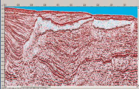
6 GEOSCIENCE EXPLAINED Deep-Water Gulf of Mexico With 12 recently announced deep-water discoveries and an aggressive leasing schedule for the Western and Central Gulf of Mexico, exploration and production technology is being pushed to its limits. To meet industry needs to image deeper and more obscure targets, TGS-NOPEC Geophysical Company has over 2.5 million km of 2-D and 88,000 km 2 of 3-D seismic data available in the Gulf, of which this line is an example. SW St MALO - DANA POINT CHIN 6 Extract GEO ExPro January 2007


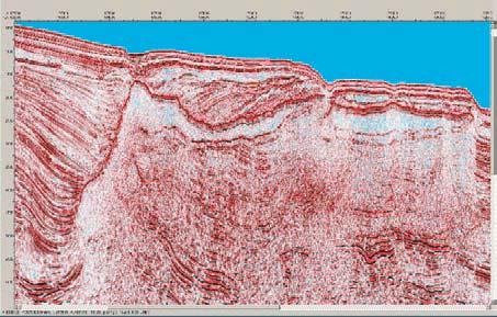
7 Sediments, similar to these off the current Mississippi delta, derived from the north, have been filling in the Gulf of Mexico since Jurassic time.. Photo: MMS Photo: Liam Gumley, NASA/SSEC The Ocean Confidence semi-submersible rig is used to drill deep prospects in the deep-water Gulf of Mexico. OK CASCADE HELENA NEPTUNE NE Extract GEO ExPro January

8
9
Geography 3202 Unit 4 S.C.O. 4.3 & 4.5. Primary Resource Activities Offshore Oil And Gas
 Geography 3202 Unit 4 S.C.O. 4.3 & 4.5 Primary Resource Activities Offshore Oil And Gas Factors Affecting The Decision To Recover Offshore Oil And Gas (4.3.1) Physical Factors 1. Ocean Related Factors
Advanced Exploration Technology & Concepts: Key to Future Gulf of Mexico Deep Shelf Oil & Gas
 Advanced Exploration Technology & Concepts: Key to Future Gulf of Mexico Deep Shelf Oil & Gas Dwight Clint Moore & Michael Neese with Rich Heaney, Bill Lefler, & Tom Uphoff GCAGS 2014 Lafayette, LA October
Salt Geology and New Plays in Deep-Water Gulf of Mexico* By Abu Chowdhury 1 and Laura Borton 1
 Salt Geology and New Plays in Deep-Water Gulf of Mexico* By Abu Chowdhury 1 and Laura Borton 1 Search and Discovery Article #10131 (2007) Posted August 25, 2007 *Adapted from extended abstract prepared
Environmental Documents Prepared for Proposed Oil, Gas, and Mineral Operations by the Gulf of Mexico Outer Continental Shelf (OCS) Region
 Region") This document is scheduled to be published in the Federal Register on 03/27/2012 and available online at http://federalregister.gov/a/2012-07364, and on FDsys.gov Billing Code: 4310-MR DEPARTMENT OF THE
This document is scheduled to be published in the Federal Register on 03/27/2012 and available online at http://federalregister.gov/a/2012-07364, and on FDsys.gov Billing Code: 4310-MR DEPARTMENT OF THE
Prospective Resources as of January 1, 2008
 Prospective Resources as of January 1, 2008 3 Mexico s prospective resources and their distribution in the most important producing basins are listed in this chapter. Pemex Exploración y Producción has
Outlook for Major Segments of the International Offshore Industry Geology and Geophysical
 2015-2017 Outlook for Major Segments of the International Offshore Industry Geology and Geophysical Dave Ridyard SVP Business Development ION Geophysical 38th ANNUAL MARINE/OFFSHORE INDUSTRY OUTLOOK CONFERENCE
QUARTERLY ACTIVITIES REPORT
 15 Rheola Street WEST PERTH WA 6005 Telephone: +61 8 9213 4388 Facsimile: +61 8 9213 4399 ASX Code: ETE ASX RELEASE 29 July 2011 QUARTERLY ACTIVITIES REPORT Entek Energy Limited provides the following
G002 An Integrated Regional Framework for Seismic Depth Imaging in the Deepwater Gulf of Mexico
 G002 An Integrated Regional Framework for Seismic Depth Imaging in the Deepwater Gulf of Mexico M. Davidson (Fugro Multi Client Services), M. Leander (Fugro Multi Client Services), K. Mohn (Fugro Multi
Phases of Disaster Response. John Yeaw, Gavin Vanstone, Haochen Wu, Jordan Tyler
 Phases of Disaster Response John Yeaw, Gavin Vanstone, Haochen Wu, Jordan Tyler BP Oil Spill One of the worst man made disasters in human history The BP oil spill occurred in April of 2010 when the Deepwater
HORDA SURVEY HERALDS NEW STRATEGY
 HORDA SURVEY HERALDS NEW STRATEGY CGG sets sights on multi-client market leadership in Norway BY IDAR HORSTAD, ERLING FRANTZEN AND JO FIRTH, CGG 12 seismic profile Figure 1: Reprocessing of the Cornerstone
For personal use only
 28 May 2012 Farm Out Arrangements Turner Bayou Project Pryme Energy Limited (Pryme) and its partners in the Turner Bayou project have established arrangements for farming out of a portion of their project
We A Multi-Measurement Integration Case Study from West Loppa Area in the Barents Sea
 We-16-12 A Multi-Measurement ntegration Case Study from West Loppa Area in the Barents Sea. Guerra* (WesternGeco), F. Ceci (WesternGeco), A. Lovatini (WesternGeco), F. Miotti (WesternGeco), G. Milne (WesternGeco),
Hurricane Katrina and Oil Spills: Impact on Coastal and Ocean Environments
 Archived version from NCDOCKS Institutional Repository http://libres.uncg.edu/ir/asu/ Pine, J. C. (June 2006). Hurricane Katrina and oil spills: Impact on coastal and ocean environments. Oceanography,
FloatSeis Technologies for Ultra-Deep Imaging Seismic Surveys
 FloatSeis Technologies for Ultra-Deep Imaging Seismic Surveys 25 th January, 2018 Aleksandr Nikitin a.nikitin@gwl-geo.com Geology Without Limits Overview 2011-2016 GWL Acquired over 43000 km 2D seismic
W. MICHAEL CLINE CONSULTING GEOPHYSICIST. T/X RESOURCES Combining Technology with Petroleum EXploration Since 1985
 T/X RESOURCES Combining Technology with Petroleum EXploration Since 1985 Introduction: I am a technically-oriented Geophysicist, with extensive seismic interpretation/reservoir analysis experience, who
Forecast of Nearshore Wave Parameters Using MIKE-21 Spectral Wave Model
 Forecast of Nearshore Wave Parameters Using MIKE-21 Spectral Wave Model Felix Jose 1 and Gregory W. Stone 2 1 Coastal Studies Institute, Louisiana State University, Baton Rouge, LA 70803 2 Coastal Studies
DYNAMIC POSITIONING CONFERENCE October 7-8, Operations. Using GIS to Understand Hurricane Windfields in the Gulf of Mexico
 Return to Session Directory DYNAMIC POSITIONING CONFERENCE October 7-8, 2008 Operations Using GIS to Understand Hurricane Windfields in the Gulf of Mexico Jill F. Hasling and Maureen T. Maiuri Weather
Downloaded 09/10/15 to Redistribution subject to SEG license or copyright; see Terms of Use at
 The role of legacy seismic in exploring new offshore hydrocarbon provinces or can you teach old data new tricks (technologies)? Howard Nicholls, Lauren Penn, Anna Marszalek, Paolo Esestime, Karyna Rodriguez,
Non-Technical Summary
 Non-Technical Summary Proposed Project TGS-NOPEC Geophysical Company ASA (TGS) proposes to undertake a two dimensional (2D) seismic survey and seabed sampling in the western Greenland Sea off North East
The AIR Hurricane Model for Offshore Assets
 The AIR Hurricane Model for Offshore Assets The combined insured losses to offshore assets caused by hurricanes in 2004 and 2005 alone were estimated at the time to be about USD 16 billion. Today, the
GEOPHYSICAL SURVEYS: What are Seismic Surveys and How are They Done?
 GEOPHYSICAL SURVEYS: What are Seismic Surveys and How are They Done? Marine Geophysical Exploration Purpose Image the subsurface Evaluate the acreage Identify potential hydrocarbon accumulations Reducing
For personal use only
 19 October 2011 AOM to expand into Shale Gas Exploration The Directors of (ASX:AOM) are pleased to announce the Company has entered into an agreement with Dr David Falvey to establish a subsidiary company,
Session 1 Presentation - Use of Offshore Energy Facilities as Deepwater Ocean Observing Platforms
 University of New Orleans ScholarWorks@UNO Ocean Waves Workshop Ocean Waves Workshop 2017 Dec 7th, 9:00 AM - 9:45 AM Session 1 Presentation - Use of Offshore Energy Facilities as Deepwater Ocean Observing
1. Canadian Energy Use
 1 Unit 3 Energy 2 1. Canadian Energy Use Why are Canadians the sixth highest energy users in the world? Our major industries are energy intensive, overall industry consumes 31% of all energy in Canada.
Full crustal seismic imaging in northeast Greenland
 Full crustal seismic imaging in northeast Greenland James W. Granath, 1 Richard C. Whittaker, 2 Vijay Singh, 3 Dale E. Bird 3 and Menno G. Dinkelman 4 describe new techniques used to acquire a 2D seismic
Exploitation of Ocean Predictions by the Oil and Gas Industry. GODAE OceanView Symposium 2013
 Exploitation of Ocean Predictions by the Oil and Gas Industry GODAE OceanView Symposium 2013 Introduction Information needs Challenges Acknowledgements IMarEST/SUT Metocean Awareness Course Colleagues
Offshore Operations and Project Execution Geophysical Site Surveys
 Offshore Operations and Project Execution Geophysical Site Surveys Chris Almond Senior Geophysicist Fugro Survey Limited 22/04/2015 Presentation Summary: Office-based Personnel Project Awarded Pre Offshore
Karoon Awarded Exploration Permit EPP46 in Australia s Most Active Exploration Province, the Ceduna Sub Basin, Great Australian Bight
 7 October 2016 ASX Announcement Karoon Awarded Exploration Permit EPP46 in Australia s Most Active Exploration Province, the Ceduna Sub Basin, Great Australian Bight Karoon Gas Australia Ltd (ASX: KAR)
Arctic Resource Potential and Development Challenges
 Arctic Resource Potential and Development Challenges Jed Hamilton Senior Arctic Consultant ExxonMobil Upstream Research Company Houston, Texas, USA Presented at In Search of Arctic Energy Forum Sponsored
Exploring Eastern Africa. East Africa Oil and Gas Summit, 2014 March 2014
 Exploring Eastern Africa East Africa Oil and Gas Summit, 2014 March 2014 1 Exploring Eastern Africa Who is Rift Energy? Why East Africa? History of an exploration asset: Block L19 Kenya Growing the portfolio
Yev Kontar. Illinois State Geological Survey, University of Illinois at Urbana-Champaign
 Addressing Caribbean Geophysical Hazards through the Continuously Operating Caribbean GPS Observational Network (COCONet) and International Ocean Drilling Program (IODP) Yev Kontar Illinois State Geological
TH P5 07 INSIGHTS INTO THE TECTONIC EVOLUTION AND PROSPECTIVITY OF MADAGASCAR OFFSHORE BASINSN
 Technical paper TH P5 07 INSIGHTS INTO THE TECTONIC EVOLUTION AND PROSPECTIVITY OF MADAGASCAR OFFSHORE BASINSN Authors R. Dirkx* (TGS), F. Winter (TGS), S. Musa (TGS), R. Cooke (TGS), B. Sayers (TGS),
Last Time. GY 305: Geophysics. Seismology (Marine Surveys) Seismology. Seismology. Other Seismic Techniques UNIVERSITY OF SOUTH ALABAMA
 Seismology. Seismology. Other Seismic Techniques UNIVERSITY OF SOUTH ALABAMA") UNIVERSITY OF SOUTH ALABAMA Last Time GY 305: Geophysics Lecture 12: Introduction to (resolution versus penetration) Techniques (marine versus terrestrial) (Marine Surveys) http://www.glossary.oilfield.slb.com/displayimage.cfm?id=236
UNIVERSITY OF SOUTH ALABAMA Last Time GY 305: Geophysics Lecture 12: Introduction to (resolution versus penetration) Techniques (marine versus terrestrial) (Marine Surveys) http://www.glossary.oilfield.slb.com/displayimage.cfm?id=236
Rockall Plateau. OCN 201: Shelf Sediments
 Rockall Plateau OCN 201: Shelf Sediments Classification by Mode of Formation Detrital sediments Transported and deposited as particles Derived from weathering of pre-existing rocks (igneous, metamorphic
MUHAMMAD S TAMANNAI, DOUGLAS WINSTONE, IAN DEIGHTON & PETER CONN, TGS Nopec Geological Products and Services, London, United Kingdom
 Geological and Geophysical Evaluation of Offshore Morondava Frontier Basin based on Satellite Gravity, Well and regional 2D Seismic Data Interpretation MUHAMMAD S TAMANNAI, DOUGLAS WINSTONE, IAN DEIGHTON
New Portfolio Asset - Namibia
 Market Announcements Platform ASX Limited Exchange Centre 20 Bridge Street Sydney NSW 2000 ASX Code: CE1 10/05/2018 New Portfolio Asset - Namibia Highlights: Calima has been awarded a 56% interest and
THE NORPHLET SANDSTONE AND OTHER PETROLEUM PLAYS ALONG AND OUTBOARD OF THE FLORIDA ESCARPMENT, EASTERN GULF OF MEXICO
 THE NORPHLET SANDSTONE AND OTHER PETROLEUM PLAYS ALONG AND OUTBOARD OF THE FLORIDA ESCARPMENT, EASTERN GULF OF MEXICO Glyn Roberts 1, Joe Erickson 2 1 Consultant, Bedford, UK; 2 Spectrum, Houston, TX.
BOEM Marine Minerals Program
 BOEM Marine Minerals Program Restoring and Protecting Our Nation s Coasts through Stewardship of OCS Sand Resources SECOORA 2018 Annual Meeting May 22-24 Doug Piatkowski Douglas.piatkowski@boem.gov 703-787-1833
KCC White Paper: The 100 Year Hurricane. Could it happen this year? Are insurers prepared? KAREN CLARK & COMPANY. June 2014
 KAREN CLARK & COMPANY KCC White Paper: The 100 Year Hurricane Could it happen this year? Are insurers prepared? June 2014 Copyright 2014 Karen Clark & Company The 100 Year Hurricane Page 1 2 COPLEY PLACE
Exploration, Drilling & Production
 Nontechnical Guide to PETMOLEUM Geology, Exploration, Drilling & Production Third Edition Norman J. Hyne, Ph.D. Contents Preface *i Introduction 1 The Nature of Gas and Oil 1 Petroleum 1 The Chemistry
Newfoundland and Labrador Resource Opportunities: 2013 Licensing Round and Beyond
 Newfoundland and Labrador Resource Opportunities: 2013 Licensing Round and Beyond David Middleton Director of Petroleum Geoscience Department of Natural Resources Government of Newfoundland and Labrador,
KENYA ONSHORE, LAMU BASIN Block L14 FARM- IN OPPORTUNITY
 KENYA ONSHORE, LAMU BASIN Block L14 FARM- IN OPPORTUNITY Lamu Oil and Gas, a joint venture between QFB and Edgo Energy, is seeking one or more partners, to continue exploration of their highly attractive
Saville Resources Inc. Completes Review of Work on the Niobium Claim Group, Quebec
 Saville Resources Inc. Completes Review of Work on the Niobium Claim Group, Quebec April 5, 2018 Saville Resources Inc. (TSXv: SRE, FSE: S0J) (the Company or Saville ) is pleased to provide an overview
Update - Testing of the Strawn Sand, White Hat 20#3, Mustang Prospect, Permian Basin, Texas
 Date: 15 April 2019 ASX Code: WEL Directors John Kopcheff Non-Executive Chairman Neville Henry Managing Director Peter Allchurch Non-Executive Director Larry Liu Non-Executive Director Lloyd Flint Company
Improved Interpretability via Dual-sensor Towed Streamer 3D Seismic - A Case Study from East China Sea
 Improved Interpretability via Dual-sensor Towed Streamer 3D Seismic - A Case Study from East China Sea S. Rongfu (CNOOC Shanghai), C. Hua (CNOOC Shanghai), W. Yun (CNOOC Shanghai), Z. Yabin (CNOOC Shanghai),
Introduction to 4D/4C OBC Technology
 The ifield - Enhancing Predicted Field Production Levels Using 4D/4C OBC Seismic Roger D. Entralgo Oceaneering International, Inc., Houston, Texas Mark W. Farine and Michael W. Briggs Sercel Inc., Houston
Downloaded 11/20/12 to Redistribution subject to SEG license or copyright; see Terms of Use at
 AVO crossplot analysis in unconsolidated sediments containing gas hydrate and free gas: Green Canyon 955, Gulf of Mexico Zijian Zhang* 1, Daniel R. McConnell 1, De-hua Han 2 1 Fugro GeoConsulting, Inc.,
dding endencies IN THE GULF MEXICO
 GULF MEXICO dding endencies IN THE OF GULF MEXICO Where are THE MOST areas offshore IN HE GOM OF Is there a Pattern (?) On the bidding activity Agenda ý % 1 $ ( 9. ç? GULF MEXICO TO THE GOM OF Looking
Testing of the Strawn Sand, White Hat 20#3, Mustang Prospect, Permian Basin, Texas
 Date: 11 April 2019 ASX Code: WEL Directors John Kopcheff Non-Executive Chairman Neville Henry Managing Director Peter Allchurch Non-Executive Director Larry Liu Non-Executive Director Lloyd Flint Company
Common Exploration Methods.
 Common Exploration Methods. The following list contains the most common methods which a company with a mineral prospecting licence in Northern Ireland might use to carry out a mineral prospecting programme.
Clint Moore with Bill Lefler, Tom Uphoff, Rich Heaney, & Mike Neese
 The Evolution of a Proven Giant Oil & Gas Play in Subsalt Miocene Lower Slope Sands-Reservoirs of the Federal Offshore OCS Shelf, US Gulf of Mexico Clint Moore with Bill Lefler, Tom Uphoff, Rich Heaney,
Introduction to Oil and Gas Production
 Introduction to Oil and Gas Production Steven Marzuola ATA Energy Conference May 4-6, 2007 Houston Texas Introduction Dope, Joints, Tripping Strippers Casing, Tubing, Liner API - American Petroleum Institute
Geophysical Site Surveys
 Geophysical Site Surveys Simon Oakley Geoscience Team Leader Fugro Survey Limited 16/04/2014 Contents Menu Introduction Section 1 - Geophysical Site Surveys - Seabed Bathymetry - Shallow Geology - Seabed
7B.4 ASSESSMENT OF THE GROSS U.S. OFFSHORE WIND ENERGY POTENTIAL
 7B.4 ASSESSMENT OF THE GROSS U.S. OFFSHORE WIND ENERGY POTENTIAL Marc Schwartz, Donna Heimiller, Steve Haymes, and Walt Musial National Renewable Energy Laboratory, Golden, Colorado 1. INTRODUCTION Offshore
PREPARED FOR: East Texas Gas Producers Association By Spears & Associates, Inc. August 2012 DRILLING IN 2012: THE PURSUIT OF OIL, THE NEGLECT OF GAS
 PREPARED FOR: East Texas Gas Producers Association By Spears & Associates, Inc. August 2012 DRILLING IN 2012: THE PURSUIT OF OIL, THE NEGLECT OF GAS This was in today s USA Today. Intentional? Spears works
Tu SRS2 07 A Full-waveform Inversion Case Study from Offshore Gabon
 Tu SRS2 07 A Full-waveform Inversion Case Study from Offshore Gabon A. Privitera (CGG), A. Ratcliffe* (CGG) & N. Kotova (CGG) SUMMARY We applied full waveform inversion to a seismic dataset from offshore
Marine Heat Flow Measurements Information Brochure
 Marine Heat Flow Measurements Information Brochure 5 1 2 3 4 5 5 6 7 8 5 9 10 11 12 13 14 5 15 16 17 18 19 20 21 5 22 0 200 400 600 800 1000 1200 1400 1600 Time (s) What is the use of heat flow measurements?
NewTechnology. Deciphering The Arctic s Depths. Mapping Uncertainty Using geostatistics to analyze reservoirs
 NewTechnology December 2009 the first word on oilpatch innovation Application of latest in exploration technologies yielding new insights into undersea geology PUBLICATIONS MAIL AGREEMENT NO. 40069240
Economic Geology Unconventional Energy Research
 Bureau of Economic Geology Unconventional Energy Research Overview for CEE meeting December, 2011 QAd2349x BUREAU OF ECONOMIC GEOLOGY Oldest research unit of The University of Texas at Austin Geological
For personal use only. COMPANY PRESENTATION June, 2012
 COMPANY PRESENTATION June, 2012 SYNOPSIS CONVENTIONAL OIL AND GAS EXPLORATION COMPANY BOARD AND MANAGEMENT OWNS >50% - NOT A LIFESTYLE COMPANY, PREVIOUS SUCCESS ASSETS HAVE EXCELLENT FISCAL TERMS, LOW
Sea-bottom shear-wave velocities and mode conversions
 Sea-bottom mode conversions Sea-bottom shear-wave velocities and mode conversions Carlos Rodriguez-Suarez and Robert R. Stewart ABSTRACT Elastic parameters for shallow marine sediments are compiled using
Petroleum Exploration
 Petroleum Exploration Upstream Petroleum Exploration The role of exploration is to provide the information required to exploit the best opportunities presented in the choice of areas, and to manage research
Downloaded 09/29/16 to Redistribution subject to SEG license or copyright; see Terms of Use at
 Richard Wright*, James Carter, Ian Atkinson, Erin Gillis, Deric Cameron, and Leona Stead, Nalcor Energy Tom Neugebauer, TGS Jerry Witney, PGS Daniel Hughes and Michael Hall, Airbus Defence and Space Summary
UKCS License P th Round Traditional Carrizo Oil & Gas, Inc. (operator) 100%
 100%") Block 22/8a Relinquishment Report UKCS License P.1797 26 th Round Traditional Carrizo Oil & Gas, Inc. (operator) 100% March 2015 Estimates, statistics, opinions and forecasts contained in this document
Block 22/8a Relinquishment Report UKCS License P.1797 26 th Round Traditional Carrizo Oil & Gas, Inc. (operator) 100% March 2015 Estimates, statistics, opinions and forecasts contained in this document
The map The ma (Somaliland ( Somaliland Somalia) SOMALIA SOMALILAND
 SOMALIA SOMALILAND") SOMALILAND COUNTRY BACKGROUND & HYDROCARBON POTENTIAL MINISTRY OF WATER & MINERAL RESOURCES PRESENTATION OUTLINE Introduction Petroleum Geology Petroleum Regulations & PSC Model Re-sizing of Blocks Current
SOMALILAND COUNTRY BACKGROUND & HYDROCARBON POTENTIAL MINISTRY OF WATER & MINERAL RESOURCES PRESENTATION OUTLINE Introduction Petroleum Geology Petroleum Regulations & PSC Model Re-sizing of Blocks Current
Non-Living Ocean Resources
 Cover Story 2 Non-Living Ocean Resources Introduction Two thirds (2/3) of the surface of the earth is covered by oceans. Resources from the oceans are essential to meet daily needs of mankind. Ocean resources
US East Coast OCS: Past, Present, and Future Hydrocarbon Potential
 US East Coast OCS: Past, Present, and Future Hydrocarbon Potential Dr. Robert Erlich Washington, D.C. 15 April 2015 For Additional Background Google: Erlich AAPG Explorer May 2014 First, Two Brief Definitions..
Deep-Water Reservoir Potential in Frontier Basins Offshore Namibia Using Broadband 3D Seismic
 Deep-Water Reservoir Potential in Frontier Basins Offshore Namibia Using Broadband 3D Seismic E. Polyaeva* (Petroleum Geo-Services), I. Thomas (Chariot Oil and Gas), C. Reiser (Petroleum Geo-Services),
Spring 2018 Drill Program
 VANCOUVER, BC / April 5, 2018 / Margaret Lake Diamonds Inc. (TSX-V: DIA; FSE: M85) ("Margaret Lake" or the "Company") is pleased to report preparations are now underway to commence a diamond drill program
Air Quality Modeling from the Offshore Energy Sector in the Gulf of Mexico: An Overview for the Oil and Gas Industry
 Air Quality Modeling from the Offshore Energy Sector in the Gulf of Mexico: An Overview for the Oil and Gas Industry Jose L. Hernandez Bureau of Ocean Energy Management New Orleans, LA Presented at American
IODP drilling and core storage facilities
 4 IODP drilling and core storage facilities Neville Exon As the knowledge obtainable from ocean drilling is various and extensive, its end-users are similarly various and extensive. Scientific ocean drilling
(Brown & Loucks, 2009)
") SECARB Phase 3, Task 15 Geological CO 2 Sequestration Capacity Estimate Offshore Northern Gulf of Mexico March 9, 2011 Prepared by David L. Carr Project Team: Cari Breton, GIS Analyst David L. Carr, Reservoir
SECARB Phase 3, Task 15 Geological CO 2 Sequestration Capacity Estimate Offshore Northern Gulf of Mexico March 9, 2011 Prepared by David L. Carr Project Team: Cari Breton, GIS Analyst David L. Carr, Reservoir
Pluto 1.5 2D ELASTIC MODEL FOR WAVEFIELD INVESTIGATIONS OF SUBSALT OBJECTIVES, DEEP WATER GULF OF MEXICO*
 Pluto 1.5 2D ELASTIC MODEL FOR WAVEFIELD INVESTIGATIONS OF SUBSALT OBJECTIVES, DEEP WATER GULF OF MEXICO* *This paper has been submitted to the EAGE for presentation at the June 2001 EAGE meeting. SUMMARY
EGAS. Ministry of Petroleum
 EGAS Ministry of Petroleum EGAS Ministry of Petroleum About The Block Location: N. El Arish offshore block is located in the extreme eastern part of the Egypt s economic water border and bounded from the
Western New York Nuclear Service Center Background and History
 Western New York Nuclear Service Center Background and History Paul J. Bembia, NYSERDA West Valley Program Director April 27, 2011 Development of a Civilian Nuclear Industry The roots of the West Valley
Outline 16: The Mesozoic World: Formation of Oil Deposits (with a side trip to the Devonian Marcellus Shale)
") Outline 16: The Mesozoic World: Formation of Oil Deposits (with a side trip to the Devonian Marcellus Shale) The first commercial oil well was drilled by Colonel Edwin Drake in Titusville, Pennsylvania,
Outline 16: The Mesozoic World: Formation of Oil Deposits (with a side trip to the Devonian Marcellus Shale) The first commercial oil well was drilled by Colonel Edwin Drake in Titusville, Pennsylvania,
Hardy Oil and Gas plc. ("Hardy" or "the Company") Publication of Technical Evaluation
 Publication of Technical Evaluation") 27 May 2009 Hardy Oil and Gas plc ("Hardy" or "the Company") Publication of Technical Evaluation Hardy Oil and Gas plc (LSE:HDY), the oil and gas exploration and production company with assets predominantly
27 May 2009 Hardy Oil and Gas plc ("Hardy" or "the Company") Publication of Technical Evaluation Hardy Oil and Gas plc (LSE:HDY), the oil and gas exploration and production company with assets predominantly
Regional-scale understanding of the geologic character and sand resources of the Atlantic inner continental shelf, Maine to Virginia
 Regional-scale understanding of the geologic character and sand resources of the Atlantic inner continental shelf, Maine to Virginia Workshop on Dredging, Beach Nourishment and Bird Conservation Atlantic
The Moving Story of Plate Tectonics
 08 January 2012 MP3 at voaspecialenglish.com The Moving Story of Plate Tectonics AP Smoke and ash from Italy's Mount Etna volcano last week FAITH LAPIDUS: This is SCIENCE IN THE NEWS in VOA Special English.
EGAS. Ministry of Petroleum and Mineral Resources EGAS
 EGAS 5 8 7 6 2 1 3 Block Summary Location: North Ras El Esh Offshore Block is located in the shallow waters of the Mediterranean Sea, at the outlet of Damietta Branch of the River Nile. The southern boundary
Planning and Operating a Transition Zone 2D Seismic Survey on Lake Tanganyika*
 Planning and Operating a Transition Zone 2D Seismic Survey on Lake Tanganyika* Doug Roberts 1 and Jeremy P. FitzPatrick 2 Search and Discovery Article #41765 (2016) Posted January 25, 2016 *Adapted from
SouthWest Energy (HK) Ltd.
 Ltd.") SouthWest Energy (HK) Ltd. Investor Presentation Cape Town October 2012 Why Are We Searching Oil in SWE Blocks? Similar geological g setting with Yemen s producing fields Oil seeps and oil show in the
SouthWest Energy (HK) Ltd. Investor Presentation Cape Town October 2012 Why Are We Searching Oil in SWE Blocks? Similar geological g setting with Yemen s producing fields Oil seeps and oil show in the
The Governor s Conference on Energy
 The Governor s Conference on Energy Track Reducing Our Dependence on Foreign Oil Session The Technology of Exploration and Development US Atlantic Margin Geotechnical Evaluation Dwight Clint Moore Vice-President
Petroleum Prospectivity in the Namibe and Southern Benguela Basins, Offshore Angola
 Petroleum Prospectivity in the Namibe and Southern Benguela Basins, Offshore Angola C. Koch* (PGS), F. Pepe (PGS), R. Vasconcelos (PGS), F. Mathew (PGS), R. Borsato (PGS) & M.P.C. de Sá (Sonangol) SUMMARY
BARRYROE OIL IN PLACE RESOURCE UPDATE
 July 25 th 2012 Embargo 7am BARRYROE OIL IN PLACE RESOURCE UPDATE UPDATED OIL IN PLACE ESTIMATES RESERVOIR INTERVAL P50 (MMBO) P10 (MMBO) MIDDLE WEALDEN 287 706 BASAL WEALDEN 756 906 TOTAL 1,043 1,612
Deepwater Subsalt-Suprasalt Middle to Lower Slope Sands & Reservoirs of the US Gulf of Mexico: The Evolution Of An Exciting Giant Field Concept
 Deepwater Subsalt-Suprasalt Middle to Lower Slope Sands & Reservoirs of the US Gulf of Mexico: The Evolution Of An Exciting Giant Field Concept Dwight Clint Moore & Bill Lefler with Rich Heaney, Mike Neese,
EGAS. Ministry of Petroleum
 EGAS Ministry of Petroleum EGAS Ministry of Petroleum About The Block Location: N. Thekah offshore block is located at about 56 km to the north of the Mediterranean shore line, 85 km to the north west
The Role of the Geoscientist in the U.S. Federal Government*
 The Role of the Geoscientist in the U.S. Federal Government* Brenda Pierce 1 Search and Discovery Article #120006 (2009) Posted November 20, 2009 *Adapted from presentation at AAPG Geoscience Technology
OTC OTC PP. Abstract
 OTC OTC-19977-PP Using Modern Geophysical Technology to Explore for Bypassed Opportunities in the Gulf of Mexico R.A. Young/eSeis; W.G. Holt, G. Klefstad/ Fairways Offshore Exploration Copyright 2009,
Vertical Hydrocarbon Migration at the Nigerian Continental Slope: Applications of Seismic Mapping Techniques.
 ROAR HEGGLAND, Statoil ASA, N-4035 Stavanger, Norway Vertical Hydrocarbon Migration at the Nigerian Continental Slope: Applications of Seismic Mapping Techniques. Summary By the use of 3D seismic data,
SEG Houston 2009 International Exposition and Annual Meeting
 Salt interpretation validated by salt tectonic study in the offshore Gulf of Mexico Li Li *, Itze Chang and Quincy Zhang, TGS-NOPEC Geophysical Company Summary To identify and define a complex salt body
Science in the News - Plate Tectonics 1. Story
 Science in the News - Plate Tectonics 1. Story Scientists who study the Earth tell us the continents and ocean floors are always moving. This movement sometimes can be violent, causing death and destruction.
SONGS Seismic Research Projects
 SONGS Seismic Research Projects Energy Division Independent Peer Review Group September 21, 2012 Agenda Background Overview Project Support Permits, Approvals, and Reviews Schedule Use of Advanced Technologies
Breaking Paradigms Giant and Super-Giant discoveries in Brazil
 Michel T. Halbouty Lecture Breaking Paradigms Giant and Super-Giant discoveries in Brazil G. Estrella Petrobras Director E&P Copyright AAPG. Serial rights given by author. For all other rights contact
Towed Streamer EM Integrated interpretation for accurate characterization of the sub-surface. PETEX, Tuesday 15th of November 2016
 Towed Streamer EM Integrated interpretation for accurate characterization of the sub-surface. PETEX, Tuesday 15th of November 2016 Joshua May Sales and Marketing Manager Agenda Introduction to Towed Streamer
COOPER BASIN DRILLING TO EVALUATE UNCONVENTIONAL POTENTIAL
 The Company Announcement Officer ASX Limited via electronic lodgement COOPER BASIN DRILLING TO EVALUATE UNCONVENTIONAL POTENTIAL OUR STRENGTHS Quality Assets Experienced Team Major Growth Potential The
Relinquishment Report
 Relinquishment Report Licence P1403 Block 13/22d Chevron North Sea Limited Korean National Oil Company Chevron North Sea Limited December 2009 1 SYNOPSIS... 3 2 INTRODUCTION. 3 2.1 Licence Terms.. 3 2.2
Earth Planet Water. Earth 71% Formation of Water on Planet. Nearly ¾ of Earth s surface is covered by liquid water More covered by solid water
 Earth Planet Water 71% Nearly ¾ of Earth s surface is covered by liquid water More covered by solid water Where is it from? Formation of Water on Planet Earth Combination of volcanic activity and strong
NEWS RELEASE ORCA GOLD REPORTS CONTINUED SUCCESS AT GSS
 NEWS RELEASE OA GOLD REPORTS CONTINUED SUCCESS AT GSS May 26, 2014 Orca Gold Inc. (TSX.V:ORG) ( Orca or the Company ) is pleased to provide an update on exploration at its Galat Sufar South ( GSS ) prospect
Oil and Gas Mineral Interest For Sale 2,145 acres in Cotton Valley/Hosston Sligo/Edwards Trend Exploration Trend
 Oil and Gas Mineral Interest For Sale 2,145 acres in Cotton Valley/Hosston Sligo/Edwards Trend Exploration Trend Milam County, Texas Fee Mineral interest is located in shallow oilfield discovered in 1940