Briefing on the work of GEBCO (GENERAL BATHYMETRIC CHART OF THE OCEANS)
|
|
|
- Robyn Evangeline Anthony
- 6 years ago
- Views:
Transcription
 7th")

1 Briefing on the work of GEBCO (GENERAL BATHYMETRIC CHART OF THE OCEANS) 7th ROPME Sea Area Hydrographic Commission Meeting, Muscat, Oman February 2017
2 What is GEBCO? The General Bathymetric Chart of the Oceans (GEBCO) (see Aims to provide the most authoritative, publicly-available bathymetric data sets for the world s oceans Operates under the joint auspices of the International Hydrographic Organization (IHO), and Intergovernmental Oceanographic Commission (IOC) of UNESCO First GEBCO paper chart series initiated in 1903 Forum for Future Ocean Floor Mapping (June 2016):

3 What is GEBCO? Imagery developed from the GEBCO global bathymetric grid (showing the shape of the sea floor in the North Atlantic Ocean) and gazetteer of undersea feature names
4 GEBCO s organisational structure GEBCO is led by a Guiding Committee consisting of five IHO-appointed members; five IOC-appointed members; Sub-committee Chairs and the Director of the IHO-DCDB It has 3 sub-committees and a number of working groups: Sub-Committee on Undersea Feature Names (SCUFN) Technical Sub-Committee on Ocean Mapping (TSCOM) Sub-Committee on Regional Undersea Mapping (SCRUM) Working groups on Outreach and the IHO-IOC GEBCO Cook Book
5 Regional mapping work GEBCO has setup the Sub-Committee on Regional Undersea Mapping (SCRUM) to: Build a closer collaboration with regional mapping efforts and coordinate, as well as encourage, the incorporation of their compilations into GEBCO. The Global GEBCO grid is continuously updated in part from these regional grids, benefiting greatly from their local knowledge and expertise.

6 Regional mapping work Coverage of some of the regional compilations included in the current GEBCO Grid
7 GEBCO s products Our bathymetric data sets and products: Global gridded bathymetric data set (30 arc-second interval) GEBCO Gazetteer of Undersea Feature Names GEBCO Digital Atlas Grid viewing software Printable maps Web Map Service (WMS) IHO-IOC GEBCO Cook Book


8 GEBCO s products: global bathymetric grid The GEBCO Grid is a global terrain model at 30 arc-second intervals: Largely based on a database of ship-track soundings with interpolation between soundings guided by satellite-derived gravity data Includes regional grids which may be based on different interpolation models Accompanied by a Source Identifier Grid showing which cells are based on soundings or existing grids and which are interpolated GEBCO s grids are made available for non-navigational purposes:

9 GEBCO s products: Source Identifier Grid The GEBCO Source Identifier (SID) Grid: Shows the source of depth value in each grid cell, i.e. if it is based on trackline data; pre-existing grids or if it is based on interpolation
10 Filling the data gaps Raising awareness of the data gaps to encourage data collection in these regions Encouraging organizations to make their bathymetric data sets easily discoverable and accessible, either directly or by contributing data to international publically-available databases such as the IHO Data Center for Digital Bathymetry (IHO-DCDB) Crowd-sourced bathymetry (CSB) initiatives such as the IHO CSB Working Group GEBCO initiative to request shallow water bathymetry data extracted from Electronic Navigation Charts from the Hydrographic community
11 Shallow water bathymetry data To more accurately model the shape of the ocean floor in all areas and serve a wider user community, GEBCO is striving to improve its gridded bathymetric datasets in shallower waters In 2006 a request was made to IHO Member States to provide ENC data (usage bands 2 and 3) to GEBCO to help update its global model New request to IHO MS for ENC data sent out in March 2016 (circular letter 11/2016)
 and 2016")
12 Shallow water bathymetry ENC data ENC data coverage (usage bands 2 & 3) provided by IHO MS and organizations, to date, to GEBCO for grid updating work after calls in 2006 (yellow) and 2016 (red),
13 Shallow water bathymetry ENC data Data for waters off Brazil Soundings points extracted from ENCs recently supplied to GEBCO for the waters off Brazil
14 Shallow water bathymetry ENC data Data for waters off Brazil
15 Shallow water bathymetry data Current GEBCO trackline coverage (black lines)
, plus ENC soundings")
16 Shallow water bathymetry data GEBCO trackline coverage (black lines), plus ENC soundings (red)


17 Shallow water bathymetry data Region off the Korean Peninsula Coverage of ENC soundings supplied to GEBCO GEBCO_2014 Grid

18 GEBCO_2014 Grid GEBCO Source Identifier Grid in part of the ROPME area showing the coverage of data sets contributing to the GEBCO_2014 Grid


19 Capacity-building initiative: The Postgraduate Certificate in Ocean Bathymetry Designed to train a new generation of scientists and hydrographers in ocean bathymetry is funded by: The Nippon Foundation of Japan and taught at: The Center for Coastal and Ocean Mapping / Joint Hydrographic Center; University of New Hampshire, USA SEE CIRCULAR LETTER 13/ February 2017

20 78 scholars from 35 coastal states over last 13 years

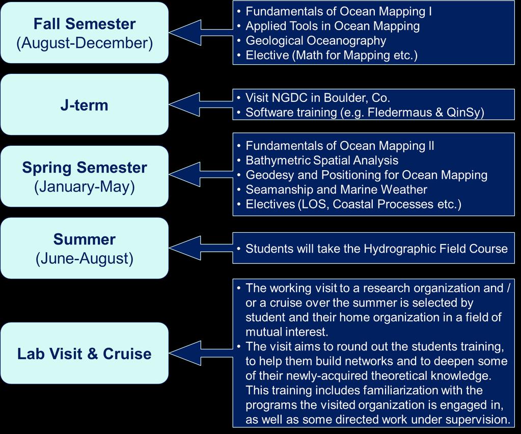
21 Training Program Content


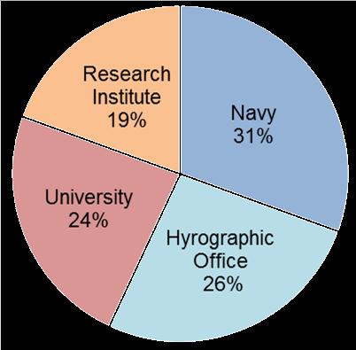
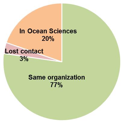
22 Measure our success? 13 years with alumni from 48 Different Organizations from 35 Coastal States


23 Nippon Foundation / GEBCO Indian Ocean Bathymetric Compilation Assemble all available bathymetric data from the different research cruises and hydrographic surveys undertaken in the Indian Ocean Publish a regional bathymetric grids that will also be integrated into the next world ocean map and grid by GEBCO UTILISE SCHOLARS NETWORKS (39 alumni from relevant states)


24 Current status of Indian Ocean Bathymetric Compilation: >85 MBES surveys and gridded compilations & > 550 SBES surveys MBES/high-resolution data coverage is very poor


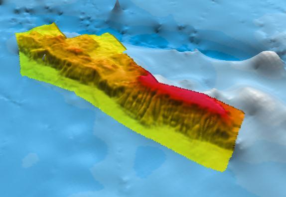
25 IOBC MBES data (500 m grid) superimposed on GEBCO_2014 Grid
26 Summary GEBCO aims to: Continually update and improve its global bathymetric model and collaborate with regional mapping groups to help achieve this Encourage (where possible) the contribution of bathymetry data to publicly-available national or international databases How to contribute data to help update GEBCO s global grid:
27 Thank you Any questions?
General Bathymetric Chart of the Oceans
 General Bathymetric Chart of the Oceans GEBCO A look at the world from an ocean s perspective On behalf of GEBCO: Boris Dorschel 1, Martin Jakobsson 2 1 Department of Geophysics, Alfred Wegener Institute
Established Global bathymetry yproducts. Undersea feature names. Capacity building
 IHO IOC Established 1903 Global bathymetry yproducts Undersea feature names Capacity building A GEBCO data GEBCO s d t sets t and d products d t Global bathymetric grids Global set of bathymetric contours
Future Ocean Floor Mapping: Ocean Stewardship & Initial Industry Contributions. U.S Hydro Galveston, TX March 23, 2017 David Millar - Fugro
 Future Ocean Floor Mapping: Ocean Stewardship & Initial Industry Contributions U.S Hydro 2017 - Galveston, TX March 23, 2017 David Millar - Fugro Presentation Outline The Need for Ocean Mapping GEBCO GEBCO
Updating the GEBCO Grid
 Updating the GEBCO Grid PAULINE WEATHERALL, GEBCO DIGITAL ATLAS MANAGER, BRITISH OCEANOGRAPHIC DATA CENTRE (BODC), NATIONAL OCEANOGRAPHY CENTRE (NOC), LIVERPOOL, UK. GEBCO TSCOM and SCRUM meeting, Kuala
The route towards a new GEBCO grid
 The route towards a new GEBCO grid Pauline Weatherall, GEBCO Digital Atlas Manager British Oceanographic Data Centre (BODC) GEBCO TSCOM/SCRUM meeting, Monaco, October 2012 The route towards a new GEBCO
IHO Input to the Report of the UN Secretary General on Oceans and Law of the Sea Executive Summary General
 IHO Input to the Report of the UN Secretary General on Oceans and Law of the Sea The following notes provide information on activities of the International Hydrographic Organization that are relevant to
Updating the GEBCO_08 Grid with regional compilations and surveys
 Updating the GEBCO_08 Grid with regional compilations and surveys Pauline Weatherall, GEBCO Digital Atlas Manager, British Oceanographic Data Centre (BODC) GEBCO TSCOM/iSCRUM meeting, SIO, October 2011
IHO Perspective on a Marine Spatial Data Infrastructure
 IHO Perspective on a Marine Spatial Data Infrastructure Anthony Pharaoh (International Hydrographic Bureau) Definitions of Hydrography on the Web: The study of the surface waters of the Earth. www.geographic.org/glossary.html
Meeting July 2018 Agenda Item 7.1. Tsunami Service Provider Messages for the Maritime Community. Submitted by IOC Secretariat SUMMARY
 WWNWS WWNWS10/7/1 Meeting 10 19 July 2018 Agenda Item 7.1 Tsunami Service Provider Messages for the Maritime Community Submitted by IOC Secretariat SUMMARY Executive Summary: This document provides details
Into the Digital Age the GEBCO Digital Atlas
 1983-2003 1983 * Digitisation of the GEBCO Fifth Edition - 1993 1993 * Initialisation of the GEBCO Digital Atlas 1993 * Updating the GEBCO Digital Atlas - 2003 Revised Bathymetry - contours Creation of
R E P U B L I C O F C Y P R U S. NATIONAL REPORT OF CYPRUS TO THE 19 th MEDITERRANEAN AND BLACK SEAS HYDROGRAPHIC COMMISSION (MBSHC)
") R E P U B L I C O F C Y P R U S NATIONAL REPORT OF CYPRUS TO THE 19 th MEDITERRANEAN AND BLACK SEAS HYDROGRAPHIC COMMISSION (MBSHC) BATUMI MEETING 30 JUNE TO 02 JULY 2015 NATIONAL REPORT OF CYPRUS TO THE
R E P U B L I C O F C Y P R U S NATIONAL REPORT OF CYPRUS TO THE 19 th MEDITERRANEAN AND BLACK SEAS HYDROGRAPHIC COMMISSION (MBSHC) BATUMI MEETING 30 JUNE TO 02 JULY 2015 NATIONAL REPORT OF CYPRUS TO THE
Billions of measurements for millions of square kilometres
 Billions of measurements for millions of square kilometres Dr. Mathias Jonas Secretary-General of the : History and Constitution 2 1 All waters on earth 3 20 th Century idea: GEBCO General bathymetric
SCAR Expert Group on IBCSO Report to GSSG
 SCAR Expert Group on IBCSO Report to GSSG Hans Werner Schenke, AWI Norbert Ott, AWI 12/16/2008 IBCSO Report to HCA-8 Niterói, 1 Content 1. Retrospect 2. Framework 3. Objectives 4. Report on IBCSO Progress
GEBCO 2013 TSCOM. EMODNET Hydrography status report
 www.emodnet-hydrography.eu GEBCO 2013 TSCOM EMODNET Hydrography status report Eric Moussat, Ifremer on behalf of the Emodnet consortium 1 Background and objectives EU proposed to take steps in 2008 towards
NOAA/University of New Hampshire Joint Hydrographic Center & Center for Coastal and Ocean Mapping. MAPPS Summer Conference July 23, 2013
 NOAA/University of New Hampshire Joint Hydrographic Center & Center for Coastal and Ocean Mapping MAPPS Summer Conference July 23, 2013 07/23/2013 2 07/23/2013 3 Center Goals To be a world leader in the
UNDERSEA FEATURE NAME PROPOSAL (See IHO-IOC Publication B-6 and NOTE overleaf)
") INTERNATIONAL HYDROGRAPHIC ORGANIZATION INTERGOVERNMENTAL OCEANOGRAPHIC COMMISSION (of UNESCO) Note: The boxes will expand as you fill the form. UNDERSEA FEATURE NAME PROPOSAL (See IHO-IOC Publication
INTERNATIONAL HYDROGRAPHIC ORGANIZATION INTERGOVERNMENTAL OCEANOGRAPHIC COMMISSION (of UNESCO) Note: The boxes will expand as you fill the form. UNDERSEA FEATURE NAME PROPOSAL (See IHO-IOC Publication
R E P U B L I C O F C Y P R U S NATIONAL REPORT OF CYPRUS TO THE MEDITERRANEAN AND BLACK SEAS HYDROGRAPHIC COMMISSION (MBSHC)
") R E P U B L I C O F C Y P R U S NATIONAL REPORT OF CYPRUS TO THE MEDITERRANEAN AND BLACK SEAS HYDROGRAPHIC COMMISSION (MBSHC) ISTANBUL MEETING 25-27 SEPTEMBER 2013 NATIONAL REPORT OF CYPRUS TO THE MEDITERRANEAN
R E P U B L I C O F C Y P R U S NATIONAL REPORT OF CYPRUS TO THE MEDITERRANEAN AND BLACK SEAS HYDROGRAPHIC COMMISSION (MBSHC) ISTANBUL MEETING 25-27 SEPTEMBER 2013 NATIONAL REPORT OF CYPRUS TO THE MEDITERRANEAN
groups.
 http://www.gebco.net GEBCO's aim is to provide the most authoritative publicly-available bathymetry of the world's oceans. It operates under the joint auspices of the Intergovernmental Oceanographic Commission
Bathymetry. EMODnet Stakeholder Conference & Sea-basin Workshops February Bathymetry
 EMODnet Stakeholder Conference & Sea-basin Workshops 14-15 February 2017 Arctic checkpoint Belinda Kater On behalf of all Checkpoints http://www.emodnet.eu 1 ? is the study of the "beds" or "floors" of
INTERNATIONAL HYDROGRAPHIC REVIEW MAY 2013
 A TECHNICAL METHOD ON CALCULATING THE LENGTH OF COASTLINE FOR COMPARISON PURPOSES Laurent LOUVART (Eng. Corps & Hydrograph., SHOM - FRANCE) on behalf of the IHO Correspondence Group Abstract A quick web
General Bathymetric Chart of the Oceans (GEBCO) The GEBCO_08 Grid
 The GEBCO_08 Grid") General Bathymetric Chart of the Oceans (GEBCO) The GEBCO_08 Grid Content i. Preface 1. Introduction - The GEBCO_08 Grid 2. Data set update history 3. Grid contents 3.1 Bathymetry data 3.2 Land data 4.
General Bathymetric Chart of the Oceans (GEBCO) The GEBCO_08 Grid Content i. Preface 1. Introduction - The GEBCO_08 Grid 2. Data set update history 3. Grid contents 3.1 Bathymetry data 3.2 Land data 4.
UNDERSEA FEATURE NAME PROPOSAL (See IHO-IOC Publication B-6 and NOTE overleaf) S (centre) S S S
 S (centre) S S S") INTERNATIONAL HYDROGRAPHIC ORGANIZATION INTERGOVERNMENTAL OCEANOGRAPHIC COMMISSION (of UNESCO) Note: The boxes will expand as you fill the form. UNDERSEA FEATURE NAME PROPOSAL (See IHO-IOC Publication
INTERNATIONAL HYDROGRAPHIC ORGANIZATION INTERGOVERNMENTAL OCEANOGRAPHIC COMMISSION (of UNESCO) Note: The boxes will expand as you fill the form. UNDERSEA FEATURE NAME PROPOSAL (See IHO-IOC Publication
INTERNATIONAL HYDROGRAPHIC BUREAU 4b, quai Antoine 1er BP 445 MC MONACO CEDEX PRINCIPAUTE DE MONACO
 IHO Input to Part I of the Report of the UN Secretary General on Oceans and Law of the Sea This contribution is provided in response to letter LOS/SGR/2015 dated 10 December 2014 as the input from the
Seabed 2030: A Call to Action
 Seabed 2030: A Call to Action Rear Adm. Shepard Smith NOAA Office of Coast Survey shep.smith@noaa.gov Introduction Many people like me start speeches about mapping the ocean with we know more about the
The role of the Italian Navy Hydrographic Institute in the Arctic activities
 The role of the Italian Navy Hydrographic Institute in the Arctic activities Luigi Sinapi Director of the Italian Hydrographic Institute Early Arctic hydrographic surveys ICE ICE Arctic hydrographic monitoring
Proposal for the preparation of a new International Bathymetric Chart of the Southern Ocean (IBCSO) to be presented at the 3 rd HCA Meeting
 to be presented at the 3 rd HCA Meeting") IHO HYDROGRAPHIC COMMITTEE ON ANTARCTICA (HCA) 3rd Meeting, IHB, Monaco, 8-10 September 2003 Dr.-Ing. Hans Werner Schenke Proposal for the preparation of a new International Bathymetric Chart of the Southern
IHO HYDROGRAPHIC COMMITTEE ON ANTARCTICA (HCA) 3rd Meeting, IHB, Monaco, 8-10 September 2003 Dr.-Ing. Hans Werner Schenke Proposal for the preparation of a new International Bathymetric Chart of the Southern
UNDERSEA FEATURE NAME PROPOSAL (See NOTE overleaf)
") INTERNATIONAL HYDROGRAPHIC ORGANIZATION INTERGOVERNMENTAL OCEANOGRAPHIC COMMISSION (of UNESCO) Note: The boxes will expand as you fill the form. UNDERSEA FEATURE NAME PROPOSAL (See NOTE overleaf) Name
INTERNATIONAL HYDROGRAPHIC ORGANIZATION INTERGOVERNMENTAL OCEANOGRAPHIC COMMISSION (of UNESCO) Note: The boxes will expand as you fill the form. UNDERSEA FEATURE NAME PROPOSAL (See NOTE overleaf) Name
Geographic Information Systems Tools for Collecting and Accessing Arctic Bathymetry: International Bathymetric Chart of the Arctic Ocean
 University of New Hampshire University of New Hampshire Scholars' Repository Center for Coastal and Ocean Mapping Center for Coastal and Ocean Mapping 1-22-2001 Geographic Information Systems Tools for
PRINCIPLES AND APPLICATIONS of OCEAN FEATURE NOMENCLATURE
 PRINCIPLES AND APPLICATIONS of OCEAN FEATURE NOMENCLATURE Michel HUET International Hydrographic Bureau MONACO "Undersea feature" is a part of the ocean floor or seabed that has measurable relief or is
Initiatives in Using Crowdsourcing, Satellite Derived Bathymetry, and Other Non-Traditional Hydrographic/Bathymetric Measurements
 University of New Hampshire University of New Hampshire Scholars' Repository Center for Coastal and Ocean Mapping Center for Coastal and Ocean Mapping 10-5-2015 Initiatives in Using Crowdsourcing, Satellite
8 th Arctic Regional Hydrographic Commission Meeting September 2018, Longyearbyen, Svalbard Norway
 8 th Arctic Regional Hydrographic Commission Meeting 11-13 September 2018, Longyearbyen, Svalbard Norway Status Report of the Arctic Regional Marine Spatial Data Infrastructures Working Group (ARMSDIWG)
14 th NIOHC, Myanmar National Report MYANMAR NAVAL HYDROGRAPHIC CENTRE (MNHC) NATIONAL REPORT HYDROGRAPHIC DEPARTMENT, ROYAL THAI NAVY-HDRTN
 NATIONAL REPORT HYDROGRAPHIC DEPARTMENT, ROYAL THAI NAVY-HDRTN") 14 th NIOHC, Myanmar National Report MYANMAR NAVAL HYDROGRAPHIC CENTRE (MNHC) NATIONAL REPORT 14 th NORTH INDIAN OCEAN HYDROGRAPHIC COMMISSION CONFERENCE HYDROGRAPHIC DEPARTMENT, ROYAL THAI NAVY-HDRTN
14 th NIOHC, Myanmar National Report MYANMAR NAVAL HYDROGRAPHIC CENTRE (MNHC) NATIONAL REPORT 14 th NORTH INDIAN OCEAN HYDROGRAPHIC COMMISSION CONFERENCE HYDROGRAPHIC DEPARTMENT, ROYAL THAI NAVY-HDRTN
EMODnet High Resolution Seabed Mapping - further developing a high resolution digital bathymetry for European seas
 EMODnet High Resolution Seabed Mapping - further developing a high resolution digital bathymetry for European seas IMDIS 2018 Conference, 7 November 2018, Barcelona - Spain Thierry Schmitt Dick M.A. Schaap
IHO MSDI Forum 30 January 2013 The IHO perspective - Is there a new role for national HO and IHO?
 International Hydrographic Organization IHO MSDI Forum 30 January 2013 The IHO perspective - Is there a new role for national HO and IHO? Michel Huet IHB XVIIIth IHC, Monaco, Apr. 2012 The main aim for
Lawrence A. Lawver Ian W.D. Dalziel Robert Larter University of Texas at Austin, Institute for Geophysics British Antarctic Survey
 20 August 2012 Prof. Hans-Werner Schenke, Chairman GEBCO Sub-Committee on Undersea Feature Names (SCUFN) International Hydrographic Bureau (IHB) 4, Quai Antoine 1er B.P. 445 MC 98011 MONACO CEDEX Principality
UNDERSEA FEATURE NAME PROPOSAL (See IHO-IOC Publication B-6 and NOTE overleaf)
") INTERNATIONAL HYDROGRAPHIC ORGANIZATION INTERGOVERNMENTAL OCEANOGRAPHIC COMMISSION (of UNESCO) Note: The boxes will expand as you fill the form. UNDERSEA FEATURE NAME PROPOSAL (See IHO-IOC Publication
INTERNATIONAL HYDROGRAPHIC ORGANIZATION INTERGOVERNMENTAL OCEANOGRAPHIC COMMISSION (of UNESCO) Note: The boxes will expand as you fill the form. UNDERSEA FEATURE NAME PROPOSAL (See IHO-IOC Publication
Crater, fault, volcanic cone, lava flow
 2-1 INTERNATIONAL HYDROGRAPHIC ORGANIZATION INTERGOVERNMENTAL OCEANOGRAPHIC COMMISSION (of UNESCO) Note: The boxes will expand as you fill the form. UNDERSEA FEATURE NAME PROPOSAL (Sea NOTE overleaf) Name
User Guide to the GEBCO Digital Atlas and its data sets
 User Guide to the GEBCO Digital Atlas and its data sets Editor: Meirion T Jones, Former Chairman, GEBCO Sub-Committee on Digital Bathymetry GDA Manager: Pauline Weatherall, BODC GDA Software: Raymond N
Capacity Building in Ocean Bathymetry The Nippon Foundation GEBCO Training Programme at the University of New Hampshire
 VOL. 6 NO. 3 (NEW SERIES) NOVEMBER 2005 Note Capacity Building in Ocean Bathymetry The Nippon Foundation GEBCO Training Programme at the University of New Hampshire Srinivas Karlapati 1, Dave Monahan 2,
Joint Hydrographic Center, National Oceanic and Atmospheric Administration, Durham, NH 03824, USA
 Future directions in hydrography using satellite-derived bathymetry Shachak Pe eri 1, Christopher Parrish 2, 3, Lee Alexander 1, Chukwuma Azuike 1, Andrew Armstrong 1,3 and Maryellen Sault 2 1 Center for
THE INTERNATIONAL HYDROGRAPHIC ORGANIZATION AND ITS INVOLVEMENT WITH GEOGRAPHICAL PLACE NAMES
 International Hydrographie Review, Monaco, LXXV(1), March 1998 THE INTERNATIONAL HYDROGRAPHIC ORGANIZATION AND ITS INVOLVEMENT WITH GEOGRAPHICAL PLACE NAMES by Adam J. KERR' INTRODUCTION It may be useful
PARTICIPATION IN THE WMO VOLUNTARY OBSERVING SHIPS (VOS) SCHEME
 SCHEME") INTERNATIONAL MARITIME ORGANIZATION 4 ALBERT EMBANKMENT LONDON SE1 7SR Telephone: 020 7735 7611 Fax: 020 7587 3210 IMO E Ref. T2-OSS/1.4 MSC.1/Circ.1293 10 December 2008 PARTICIPATION IN THE WMO VOLUNTARY
INTERNATIONAL MARITIME ORGANIZATION 4 ALBERT EMBANKMENT LONDON SE1 7SR Telephone: 020 7735 7611 Fax: 020 7587 3210 IMO E Ref. T2-OSS/1.4 MSC.1/Circ.1293 10 December 2008 PARTICIPATION IN THE WMO VOLUNTARY
Coordinates : A - of midpoint or summit : Lat., Long. } to. Description (kind of feature) : seachannel
 : seachannel") INTERNATIONAL HYDROGRAPHIC ORGANIZATION INTERGOVERNMENTAL OCEANOGRAPHIC COMMISSION (of UNESCO) IHO/IOC Form No. 1 UNDERSEA FEATURE NAME PROPOSAL (See NOTE overleaf) Ocean or Sea Japan Sea Name proposed
INTERNATIONAL HYDROGRAPHIC ORGANIZATION INTERGOVERNMENTAL OCEANOGRAPHIC COMMISSION (of UNESCO) IHO/IOC Form No. 1 UNDERSEA FEATURE NAME PROPOSAL (See NOTE overleaf) Ocean or Sea Japan Sea Name proposed
National Report of Finland
 National Report of 1. Finnish Hydrographic Office The Finnish Hydrographic Office (FHO) is responsible for nautical charting over the Finnish sea area and the most important inland water bodies. This covers
NEW TOOLS TO IMPROVE DESKTOP SURVEYS
 NEW TOOLS TO IMPROVE DESKTOP SURVEYS Pablo Vengoechea (Telemediciones S.A.), Jorge O. García (Telemediciones S.A.), Email: Telemediciones S.A. / Cra. 46 94-17 Bogotá D.C.
UNDERSEA FEATURE NAME PROPOSAL (Sea NOTE overleaf)
") INTERNATIONAL HYDROGRAPHIC ORGANIZATION INTERGOVERNMENTAL OCEANOGRAPHIC COMMISSION (of UNESCO) Note: The boxes will expand as you fill the form. UNDERSEA FEATURE NAME PROPOSAL (Sea NOTE overleaf) Name
INTERNATIONAL HYDROGRAPHIC ORGANIZATION INTERGOVERNMENTAL OCEANOGRAPHIC COMMISSION (of UNESCO) Note: The boxes will expand as you fill the form. UNDERSEA FEATURE NAME PROPOSAL (Sea NOTE overleaf) Name
A Case Study in Land and Sea Data Interoperability
 Andrew HOGGARTH, CANADA, Gordon JOHNSTON, UNITED KINGDOM, Charles de Jongh and Peter Schwarzberg, NETHERLANDS Key words: Disaster Planning, Coast, Bathymetry, Database, Interoperability SUMMARY In Mozambique
Economic and Social Council
 United Nations Economic and Social Council Distr.: General 25 May 2012 Original: English E/CONF.101/113 Tenth United Nations Conference on the Standardization of Geographical Names New York, 31 July 9
Capacity Building in Ocean Bathymetry The Nippon Foundation GEBCO Training Programme at the University of N ew Hampshire
 Rectification We sincerely regret that in the November issue of IHR, the Note of Karlapati et al. was published with incorrect illustrations. Printed below is the Note as it should have been released.
COMNAP REPORT TO HCA OCT 09
 HCA9-06.2A COMNAP REPORT TO HCA-9 12-14 OCT 09 About COMNAP Pupose : To develop and promote best practice in managing the support of scientific research in Antarctica How Serving as a forum to develop
STATUS QUO REPORT ON ENC ACTIVITIES
 NETWORK OF DANUBE WATERWAY ADMINISTRATIONS South-East European Transnational Cooperation Programme STATUS QUO REPORT ON ENC ACTIVITIES UA - SHS Document ID: Activity: 5.2 Author / Project Partner: Date:
UNDERSEA FEATURE NAME PROPOSAL (Sea NOTE overleaf)
") INTERNATIONAL HYDROGRAPHIC ORGANIZATION INTERGOVERNMENTAL OCEANOGRAPHIC COMMISSION (of UNESCO) Note: The boxes will expand as you fill the form. UNDERSEA FEATURE NAME PROPOSAL (Sea NOTE overleaf) Name
INTERNATIONAL HYDROGRAPHIC ORGANIZATION INTERGOVERNMENTAL OCEANOGRAPHIC COMMISSION (of UNESCO) Note: The boxes will expand as you fill the form. UNDERSEA FEATURE NAME PROPOSAL (Sea NOTE overleaf) Name
Critical issues relating to the integration of land and marine geospatial information
 Committee of Experts on Background document 1 Global Geospatial Information Management Available in English only Third session Cambridge, United Kingdom of Great Britain and Northern Ireland 24-26 July
UNDERSEA FEATURE NAME PROPOSAL (Sea NOTE overleaf)
") INTERNATIONAL HYDROGRAPHIC ORGANIZATION INTERGOVERNMENTAL OCEANOGRAPHIC COMMISSION (of UNESCO) Note: The boxes will expand as you fill the form. UNDERSEA FEATURE NAME PROPOSAL (Sea NOTE overleaf) Name
INTERNATIONAL HYDROGRAPHIC ORGANIZATION INTERGOVERNMENTAL OCEANOGRAPHIC COMMISSION (of UNESCO) Note: The boxes will expand as you fill the form. UNDERSEA FEATURE NAME PROPOSAL (Sea NOTE overleaf) Name
EMODnet High Resolution Seabed Mapping - further developing and providing a high resolution digital bathymetry for European seas
 EMODnet High Resolution Seabed Mapping - further developing and providing a high resolution digital bathymetry for European seas EGU Fall 2017 meeting New Orleans USA, December 2017 Schaap Dick MARIS,
Options in Capacity Building. Underpinning the Blue Economy. Slide 1/78. Derrick R. Peyton. 14 th MACHC Meeting. IIC Technologies. December 9-13, 2013
 Options in Capacity Building Underpinning the Blue Economy Derrick R. Peyton IIC Technologies 14 th MACHC Meeting December 9-13, 2013 Slide 1/78 Overview Blue Economy Defined Challenges (SDI, MSDI, Standards)
Coordinates : A - of midpoint or summit : Lat S, Long W
 INTERNATIONAL HYDROGRAPHIC ORGANIZATION SCUFN19-6.1K INTERGOVERNMENTAL OCEANOGRAPHIC COMMISSION (of UNESCO) IHO/IOC Form No. 1 UNDERSEA FEATURE NAME PROPOSAL (See NOTE overleaf) Ocean or Sea: Scotia Sea
CANADIAN HYDROGRAPHIC SERVICE
 CANADIAN HYDROGRAPHIC SERVICE Surveying and Charting Canada s Waters Since 1883 Ilulisat Maritime Workshop 2017 The Importance and Need for Hydrography Denis Hains, Hydrographer General of Canada & Director
Seabed knowledge In support of UN SDGs
 Seabed knowledge In support of UN SDGs Evert Flier Fiskerifaglig forum 2. november 2017 Hydrography & small scale fishing Hydrography in Transition Serving the Maritime Community Hydrography in Transition
Current Hydrographic Projects at BSH
 7 th Workshop Seabed Acoustics, Rostock, November 19/20, 2015 P01-1 Current Hydrographic Projects at BSH Thomas Dehling Federal Maritime and Hydrographic Agency (BSH) Germany Contact Address Website BSH
Pan American Institute of Geography and History. 12th MACHC 5-9 December 2011
 Pan American Institute of Geography and History 12th MACHC 5-9 December 2011 1 PAIGH Mission and Objectives To encourage, coordinate, and publicize cartographical, geographical, geophysical and historical
Mapping Undersea Feature Names in S-100. UFNPT at SCUFN 31 Wellington, New Zealand October, 2018
 Mapping Undersea Feature Names in S-100 UFNPT at SCUFN 31 Wellington, New Zealand October, 2018 Content - Update about UFNPT - Discovery of Undersea Features - excercise Work Plan of the UFNPT November
PAKISTAN NATIONAL REPORT
 PAKISTAN NATIONAL REPORT 16 th MEETING NORTH INDIAN OCEAN HYDROGRAPHIC COMMISSION (NIOHC) CHITTAGONG, BANGLADESH 14-16 MARCH 2016 BY PAKISTAN NAVY HYDROGRAPHIC DEPARTMENT HYDROGRAPHIC DEPARTMENT OF PAKISTAN
UNDERSEA FEATURE NAME PROPOSAL (See NOTE overleaf) Ocean or Sea Atlantic Ocean Name proposed Jean Charcot Seamounts. kilometres in direction from
 Ocean or Sea Atlantic Ocean Name proposed Jean Charcot Seamounts. kilometres in direction from") INTERNATIONAL HYDROGRAPHIC ORGANIZATION INTERGOVERNMENTAL OCEANOGRAPHIC COMMISSION (of UNESCO) IHO/IOC Form No. 1 UNDERSEA FEATURE NAME PROPOSAL (See NOTE overleaf) Ocean or Sea Atlantic Ocean Name proposed
INTERNATIONAL HYDROGRAPHIC ORGANIZATION INTERGOVERNMENTAL OCEANOGRAPHIC COMMISSION (of UNESCO) IHO/IOC Form No. 1 UNDERSEA FEATURE NAME PROPOSAL (See NOTE overleaf) Ocean or Sea Atlantic Ocean Name proposed
The french national programme for claiming continental shelf beyond 200 Miles
 The french national programme for claiming continental shelf beyond 200 Miles Using global bathymetric models in the context of an Extended Continental Shelf submission EXTRAPLAC Using Global Bathymetric
Charles Magori. Status Report of GLOSS Tide Gauges in Kenya
 GLOSS Group of Experts Meeting February 2005 Charles Magori Introduction Status Report of GLOSS Tide Gauges in Kenya There is growing concern about the rise in mean sea level around the globe. To address
Maritime Standards. Rafael Ponce Tom De Puyt
 Maritime Standards Rafael Ponce Tom De Puyt Content The International Hydrographic Organization - Overview - Existing Support - Committees and Working Groups - Technology - Runtime - MCS Next Generation
INTERNATIONAL HYDROGRAPHIC ORGANIZATION MESO AMERICAN & CARIBBEAN SEA HYDROGRAPHIC COMMISSION
 INTERNATIONAL HYDROGRAPHIC ORGANIZATION MESO AMERICAN & CARIBBEAN SEA HYDROGRAPHIC COMMISSION CAPACITY BUILDING PLAN Programme document for the period 2010-2012 1. INTRODUCTION 1.1. Rationale It is estimated
IHO STAKEHOLDERS FORUM. Hydrographic data and its role in MSDI. Thursday 27 September Jens Peter Hartmann KMS
 IHO STAKEHOLDERS FORUM Hydrographic data and its role in MSDI Thursday 27 September Jens Peter Hartmann KMS Agenda Traditional approach to hydrographic data Expectations within the marine / maritime field
Proposal to Include a Grid Referencing System in S-100
 1 st IHO-HSSC Meeting The Regent Hotel, Singapore, 22-24 October 2009 Paper for consideration by HSSC Proposal to Include a Grid Referencing System in S-100 Submitted by: Executive Summary: Related Documents:
Figure 3.1: Illustration showing the bathymetry s role for the tsunami propagation following the earth quake 26 December 2004 outside of Sumatra.
 Figure 3.1: Illustration showing the bathymetry s role for the tsunami propagation following the earth quake 26 December 2004 outside of Sumatra. The left globe shows the seafloor bathymetry as portrayed
JCOMM Overview. Val Swail Environment and Climate Change Canada JCOMM representative to IOGP Metocean Committee
 JCOMM Overview Val Swail Environment and Climate Change Canada JCOMM representative to IOGP Metocean Committee IOGP/JCOMM/WCRP Workshop Our Future Climate Understanding the spread of physical risk for
Outreach Activities for Promoting a Wider Use of Marine Geographical Names *
 UNITED NATIONS GROUP OF EXPERTS Working Paper ON GEOGRAPHICAL NAMES No. 62/13 Twenty-ninth Session Bangkok, Thailand, 25 to 29 April 2016 Item 13 of the provisional agenda Activities relating to the Working
Enabling Access to Arctic Location Based Information - the Arctic SDI
 Enabling Access to Arctic Location Based Information - the Arctic SDI Jani Kylmäaho Head of Arctic SDI Geoportal WG National Land Survey of Finland SAO Chair, WG Chairs and Executive Secretaries meeting
Inspire Conference Istanbul, 2012 Ralf Lindgren. Inspire Conference Istanbul, 2012 Ralf Lindgren
 Background A Baltic Sea Bathymetry Database Concept and Hans Öiås Swedish Maritime Administration Hydrographic Office A national directive: The Swedish Maritime Administration shall, in cooperation with
12/11/2013& egm502 seafloor mapping
 egm502 seafloor mapping lecture 13 multi-beam echo-sounders The majority of the current charts of the ocean floors have been produced from single beam echo-sounder data. Even though these data have been
STUDY ON STANDARDIZATION OF HYDROGRAPHIC SURVEYING AND CHARTING
 STUDY ON STANDARDIZATION OF HYDROGRAPHIC Li, S., Wu, D., Yin, X. and Cui, Y. The department of Hydrography and Cartography, Dalian Naval Academy, 667, Jiefang Road, Dalian, Liaoning, 116018,P.R.China.
SAIHC 13 th Meeting Cape Town August 2016
 SAIHC 13 th Meeting Cape Town 30-31 August 2016 SAIHC National Report NORWAY NATIONAL REPORT NORWAY Executive Summary This report gives the summary of the activities and events that have taken place within
Coastal Response Research Center. Nancy Kinner University of New Hampshire (UNH) Michele Jacobi NOAA ORR. September 27, 2007
 Michele Jacobi NOAA ORR. September 27, 2007") Coastal Response Research Center Nancy Kinner University of New Hampshire (UNH) Michele Jacobi NOAA ORR September 27, 2007 1 Coastal Response Research Center (CRRC) CRRC is partnership between NOAA s Office
Coastal Response Research Center Nancy Kinner University of New Hampshire (UNH) Michele Jacobi NOAA ORR September 27, 2007 1 Coastal Response Research Center (CRRC) CRRC is partnership between NOAA s Office
General Bathymetric Chart of the Oceans (GEBCO)
") Distribution: limited Sub-Committee on Digital Bathymetry XXIV English only 17 September 2008 INTERGOVERNMENTAL OCEANOGRAPHIC COMMISSION (of UNESCO) INTERNATIONAL HYDROGRAPHIC ORGANIZATION General Bathymetric
Distribution: limited Sub-Committee on Digital Bathymetry XXIV English only 17 September 2008 INTERGOVERNMENTAL OCEANOGRAPHIC COMMISSION (of UNESCO) INTERNATIONAL HYDROGRAPHIC ORGANIZATION General Bathymetric
1 Introduction / Background
 HSSC3-03C rev1 3 rd IHO-HSSC Meeting IHB, Monaco, 8-10 November 2011 Report to HSSC-3 by the Correspondence Group on Definition and Length of Coastline Submitted by: France Executive Summary: This paper
UNDERSEA FEATURE NAME PROPOSAL. Name Proposed: Kiminu Seamount. to Long.
 INTERNATIONAL HYDROGRAPHIC ORGANIZATION INTERNATIONAL OCEANOGRAPHIC COMMISSION (of UNESCO) UNDERSEA FEATURE NAME PROPOSAL Ocean or Sea: East Sea Name Proposed: Coordinates: A of midpoint or summit: Lat.
National Report of Finland
 of Executive Summary This Report highlights the main activities and achievements of the Finnish Hydrographic Office since BSHC 22 nd Conference in September 2017. - The amount of Hydrographic surveys has
COVERAGE-Sargasso Sea
 COVERAGE-Sargasso Sea A Collaborative Project between NASA and the Sargasso Sea Commission Dr. Vardis Tsontos Dr. Jorge Vazquez NASA Jet Propulsion Laboratory, California Institute of Technology UN-HQ
PAKISTAN NAVY HYDROGRAPHIC DEPARTMENT
 PAKISTAN NATIONAL REPORT 5th MEETING ROPME SEA ARAE HYDROGRAPHIC COMMISSION (RASHC) Riyadh, Saudi Arabia 04-06 March 2013 PAKISTAN NAVY HYDROGRAPHIC DEPARTMENT HYDROGRAPHIC DEPARTMENT OF PAKISTAN (NATIONAL
4 th IHO-HSSC Meeting IHB, Taunton, September Report to HSSC-4 by the Correspondence Group on Definition and Length of Coastline
 HSSC4-03C rev1 4 th IHO-HSSC Meeting IHB, Taunton, 25-28 September 2012 Report to HSSC-4 by the Correspondence Group on Definition and Length of Coastline Submitted by: France Executive Summary: This paper
Marine environment monitoring : The basic requirements to support Marine Renewable Energies
 Marine environment monitoring : The basic requirements to support Marine Renewable Energies SHOM in brief SHOM is the French Government agency in charge of Hydrography and Oceanography SHOM s vocation
Marine Notice No. 13 of 2009
 Marine Notice No. 13 of 2009 NOTICE TO ALL SHIPOWNERS, FISHING VESSEL OWNERS, AGENTS, SHIPMASTERS, SHIP MANAGEMENT COMPANIES, SKIPPERS, FISHERMEN, YACHTSMEN AND SEAFARERS. HELP IMPROVE QUALITY OF WEATHER
THAILAND NATIONAL REPORT
 NIOHC18 TH National Report THAILAND NATIONAL REPORT 18 th NORTH INDIAN OCEAN HYDROGRAPHIC COMMISSION (NIOHC) CONFERENCE Goa, India 9 th 12 th April 2018-1 - CONTENTS 1. Hydrographic Office / Service 3
REPORT BY THE HYDROGRAPHIC AND GEODETIC SERVICE OF THE REPUBLIC OF CUBA. 18 th MESO AMERICAN AND CARIBBEAN SEA HYDROGRAPHIC COMMISSION MEETING
 REPORT BY THE HYDROGRAPHIC AND GEODETIC SERVICE OF THE REPUBLIC OF CUBA 18 th MESO AMERICAN AND CARIBBEAN SEA HYDROGRAPHIC COMMISSION MEETING 1. STRUCTURE OF THE HYDROGRAPHIC AND GEODETIC SERVICE OF THE
Asano Seamount, MIT Guyot
 2-1 INTERNATIONAL HYDROGRAPHIC ORGANIZATION INTERGOVERNMENTAL OCEANOGRAPHIC COMMISSION (of UNESCO) Note: The boxes will expand as you fill the form. UNDERSEA FEATURE NAME PROPOSAL (Sea NOTE overleaf) Name
OCEANOGRAPHIC DATA MANAGEMENT
 OCEANOGRAPHIC DATA MANAGEMENT Presented to: Environmental Disaster Data Management Meeting Russ Beard Director, National Coastal Data Development Center Interim Science Coordinator, Gulf Restoration Council
SAIHC 10 th Meeting Lisbon September 2013
 SAIHC 10 th Meeting Lisbon 17-18 September 2013 National Report NORWAY NATIONAL REPORT NORWAY Executive Summery This report gives the summary of the activities and events that has taken place within the
Open Geospatial Consortium activities in the Maritime domain
 Open Geospatial Consortium activities in the Maritime domain Scott Simmons Executive Director, Standards Program General Maritime efforts participants Alliance partners IHO ISO / TC 211 Members Danish
Briefing Notes for World Hydrography Day
 Briefing Notes for World Hydrography Day - 2017 Mapping our seas, oceans and waterways - more important than ever Purpose of World Hydrography Day In 2005, the General Assembly of the United Nations (UN)
Areas Beyond National Jurisdiction (ABNJ) 2016 Regional Leaders Program. March 22 to April 1, 2016 United Nations, New York
 2016 Regional Leaders Program. March 22 to April 1, 2016 United Nations, New York") Areas Beyond National Jurisdiction (ABNJ) 2016 Regional Leaders Program March 22 to April 1, 2016 United Nations, New York Welcome and Introductions Biliana Cicin-Sain President, Global Ocean Forum Vladimir
Areas Beyond National Jurisdiction (ABNJ) 2016 Regional Leaders Program March 22 to April 1, 2016 United Nations, New York Welcome and Introductions Biliana Cicin-Sain President, Global Ocean Forum Vladimir
National Marine Sanctuary Program
 National Marine Sanctuary Program NMSP/USGS Joint Seabed Mapping Initiative: September 2004 AA National Ocean Service National Marine Sanctuaries Interim Report September 2004 Background: Since 2002,
JCOMM-CHy Coastal Inundation Forecasting Demonstration Project (CIFDP)
") WMO World Meteorological Organization Working together in weather, climate and water JCOMM-CHy Coastal Inundation Forecasting Demonstration Project (CIFDP) Coastal Flooding & Vulnerable Populations Coastal
WMO World Meteorological Organization Working together in weather, climate and water JCOMM-CHy Coastal Inundation Forecasting Demonstration Project (CIFDP) Coastal Flooding & Vulnerable Populations Coastal
Economic and Social Council 10 July 2013
 ADVANCE UNEDITED VERSION UNITED NATIONS E/C.20/2013/10/Add.1 Economic and Social Council 10 July 2013 Committee of Experts on Global Geospatial Information Management Third session Cambridge, United Kingdom
Appendix E: Oceanographic Databases
 Appendix E: Oceanographic Databases Many of the principal U.S. and international database depositories for worldwide ocean observations are listed below, as are a few technical reports with descriptions