Geographic Information Systems Tools for Collecting and Accessing Arctic Bathymetry: International Bathymetric Chart of the Arctic Ocean
|
|
|
- Felicity Boone
- 5 years ago
- Views:
Transcription

1 University of New Hampshire University of New Hampshire Scholars' Repository Center for Coastal and Ocean Mapping Center for Coastal and Ocean Mapping Geographic Information Systems Tools for Collecting and Accessing Arctic Bathymetry: International Bathymetric Chart of the Arctic Ocean Martin Jakobsson University of New Hampshire, Durham Follow this and additional works at: Part of the Oceanography and Atmospheric Sciences and Meteorology Commons Recommended Citation Jakobsson, Martin, "Geographic Information Systems Tools for Collecting and Accessing Arctic Bathymetry: International Bathymetric Chart of the Arctic Ocean" (2001). Arctic Geographic Information Systems (AGIS) This Conference Proceeding is brought to you for free and open access by the Center for Coastal and Ocean Mapping at University of New Hampshire Scholars' Repository. It has been accepted for inclusion in Center for Coastal and Ocean Mapping by an authorized administrator of University of New Hampshire Scholars' Repository. For more information, please contact
2 Geographic Information Systems Tools for Collecting and Accessing Arctic Bathymetry: International Bathymetric Chart of the Arctic Ocean This conference proceeding is available at University of New Hampshire Scholars' Repository:

 Martin Jakobsson")

3 GIS Tools for Accessing Arctic Bathymetry: International Bathymetric Chart of the Arctic Ocean (IBCAO) Martin Jakobsson Center for Coastal and Ocean Mapping Joint Hydrographic Center University of New Hampshire

4 1. The IBCAO bathymetry model 2. Users of IBCAO 3. GIS tools for accessing the IBCAO grid model 4. Future IBCAO GIS products (Error estimation of the IBCAO bathymetry, vector contours)

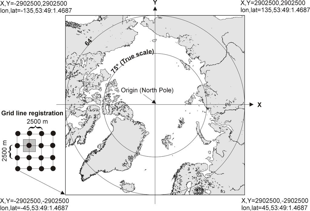
5 IBCAO Grid model representing Arctic Ocean bathymetry and topography Grid cell spacing: 2.5 x 2.5 km Projection: Polar stereographic True scale: 75º N Datum: WGS 84

6 TRACKLINE SOURCES

7 MAP SOURCES


8 SOURCES


9 Data gathering (MGE) GRID COMPILATION Block median filtering Data cleaning & mining (MGE) Gridding using continuous curvature splines in tension (Smith & Wessel, 1990)
10

11


12

13 IBCAO web site:
14 USERS OF THE IBCAO BATHYMETRY GRID Oceanography modeling (e.g. Arctic ice-ocean model for the Polar Ice prediction System (PIPS), US Naval Postgraduate School; ARCICE, Southampton Oceanography Centre, UK) Geophysical modeling Ice sheet modeling Cartographic applications IBCAO web site news: February, accesses and hits IBCAO web site statistics Mar 22-Mar 5-Apr 19-Apr 3-May 17-May 31-May 7-Jun 28-Jun 12-Jul 26-Jul 9-Aug 23-Aug 6-Sep 20-Sep 4-Oct 18-Oct 1-Nov
 Geomedia (MFworks from ThinkSpace Inc.")
15 GIS Tools for accessing the IBCAO model ESRI: ArcView, ArcInfo (Spatial Analyst, Arc Grid) Intergraph: MGE (Terrain Analyst) Geomedia (MFworks from ThinkSpace Inc.) Clarks Labs: Idrisi32 Caris: HIPS

16 Geophysical and Mapping softwares IVS: Fledermaus Public domain: Generic Mapping Tools Web GIS tools Intergraph: Geomedia Web Map ESRI: ArcIMS3
17 THE NESSECITY FOR AN ERROR ESTIMATION Regional grid models representing bathymetry/topography are often used as a base for oceanographic/climate/geophysical/ice sheet modeling The modeling results are often interpreted without knowledge of the spatial differences in reliability of the underlying bathymetry/topography model The idea is to create a grid with the same structure as the bathymetry/topography grid containing an estimate of the standard deviation of the errors of the bathymetry/topography
 Go through the process with which the bathymetry grid is")
18 USING THE MONTE CARLO METHOD FOR ERROR ESTIMATION Randomly vary the source data within constraints determined by meta data (navigation, echo sounder etc) Go through the process with which the bathymetry grid is compiled (block median filtering + continuous curvature splines in tension) This processes are continued until


19 STATISTICS σ Run 1... Run n
")
20 Standard deviation of estimated error (% of block median depth)

21 IBCAO contours in Geomedia
Updating the GEBCO Grid
 Updating the GEBCO Grid PAULINE WEATHERALL, GEBCO DIGITAL ATLAS MANAGER, BRITISH OCEANOGRAPHIC DATA CENTRE (BODC), NATIONAL OCEANOGRAPHY CENTRE (NOC), LIVERPOOL, UK. GEBCO TSCOM and SCRUM meeting, Kuala
Initiatives in Using Crowdsourcing, Satellite Derived Bathymetry, and Other Non-Traditional Hydrographic/Bathymetric Measurements
 University of New Hampshire University of New Hampshire Scholars' Repository Center for Coastal and Ocean Mapping Center for Coastal and Ocean Mapping 10-5-2015 Initiatives in Using Crowdsourcing, Satellite
Proposal for the preparation of a new International Bathymetric Chart of the Southern Ocean (IBCSO) to be presented at the 3 rd HCA Meeting
 to be presented at the 3 rd HCA Meeting") IHO HYDROGRAPHIC COMMITTEE ON ANTARCTICA (HCA) 3rd Meeting, IHB, Monaco, 8-10 September 2003 Dr.-Ing. Hans Werner Schenke Proposal for the preparation of a new International Bathymetric Chart of the Southern
IHO HYDROGRAPHIC COMMITTEE ON ANTARCTICA (HCA) 3rd Meeting, IHB, Monaco, 8-10 September 2003 Dr.-Ing. Hans Werner Schenke Proposal for the preparation of a new International Bathymetric Chart of the Southern
General Bathymetric Chart of the Oceans
 General Bathymetric Chart of the Oceans GEBCO A look at the world from an ocean s perspective On behalf of GEBCO: Boris Dorschel 1, Martin Jakobsson 2 1 Department of Geophysics, Alfred Wegener Institute
Multibeam Mapping of Feature Rich Seafloor in the U.S. Pacific Remote Islands Marine National Monument and on Mendocino Ridge off the California Coast
 University of New Hampshire University of New Hampshire Scholars' Repository Center for Coastal and Ocean Mapping Center for Coastal and Ocean Mapping 3-2015 Multibeam Mapping of Feature Rich Seafloor
Bathymetric Attributed Grids (BAGs): Discovery of Marine Datasets and Geospatial Metadata Visualization
: Discovery of Marine Datasets and Geospatial Metadata Visualization") University of New Hampshire University of New Hampshire Scholars' Repository Center for Coastal and Ocean Mapping Center for Coastal and Ocean Mapping 2010 Bathymetric Attributed Grids (BAGs): Discovery
University of New Hampshire University of New Hampshire Scholars' Repository Center for Coastal and Ocean Mapping Center for Coastal and Ocean Mapping 2010 Bathymetric Attributed Grids (BAGs): Discovery
Established Global bathymetry yproducts. Undersea feature names. Capacity building
 IHO IOC Established 1903 Global bathymetry yproducts Undersea feature names Capacity building A GEBCO data GEBCO s d t sets t and d products d t Global bathymetric grids Global set of bathymetric contours
GAMINGRE 8/1/ of 7
 FYE 09/30/92 JULY 92 0.00 254,550.00 0.00 0 0 0 0 0 0 0 0 0 254,550.00 0.00 0.00 0.00 0.00 254,550.00 AUG 10,616,710.31 5,299.95 845,656.83 84,565.68 61,084.86 23,480.82 339,734.73 135,893.89 67,946.95
Briefing on the work of GEBCO (GENERAL BATHYMETRIC CHART OF THE OCEANS)
") Briefing on the work of GEBCO (GENERAL BATHYMETRIC CHART OF THE OCEANS) 7th ROPME Sea Area Hydrographic Commission Meeting, Muscat, Oman 20-22 February 2017 What is GEBCO? The General Bathymetric Chart
Briefing on the work of GEBCO (GENERAL BATHYMETRIC CHART OF THE OCEANS) 7th ROPME Sea Area Hydrographic Commission Meeting, Muscat, Oman 20-22 February 2017 What is GEBCO? The General Bathymetric Chart
4D Multimodal Visualization and Analysis of Seafloor Vents and Plumes
 University of New Hampshire University of New Hampshire Scholars' Repository Center for Coastal and Ocean Mapping Center for Coastal and Ocean Mapping 6-2010 4D Multimodal Visualization and Analysis of
University of New Hampshire Scholars' Repository
 University of New Hampshire University of New Hampshire Scholars' Repository Center for Coastal and Ocean Mapping Center for Coastal and Ocean Mapping 3-2009 Environmental Response Management Application
Evaluating the USACE's NCMP for NOAA charting operations
 University of New Hampshire University of New Hampshire Scholars' Repository Center for Coastal and Ocean Mapping Center for Coastal and Ocean Mapping 8-2013 Evaluating the USACE's NCMP for NOAA charting
The route towards a new GEBCO grid
 The route towards a new GEBCO grid Pauline Weatherall, GEBCO Digital Atlas Manager British Oceanographic Data Centre (BODC) GEBCO TSCOM/SCRUM meeting, Monaco, October 2012 The route towards a new GEBCO
In Centre, Online Classroom Live and Online Classroom Programme Prices
 In Centre, and Online Classroom Programme Prices In Centre Online Classroom Foundation Certificate Bookkeeping Transactions 430 325 300 Bookkeeping Controls 320 245 225 Elements of Costing 320 245 225
UWM Field Station meteorological data
 University of Wisconsin Milwaukee UWM Digital Commons Field Station Bulletins UWM Field Station Spring 992 UWM Field Station meteorological data James W. Popp University of Wisconsin - Milwaukee Follow
Characterization of the Nigerian Shoreline using Publicly-Available Satellite Imagery
 University of New Hampshire University of New Hampshire Scholars' Repository Center for Coastal and Ocean Mapping Center for Coastal and Ocean Mapping 1-2014 Characterization of the Nigerian Shoreline
SPECIMEN. Date Morning/Afternoon. A Level Geography H481/01 Physical systems Sample Question Paper. Time allowed: 1 hour 30 minutes PMT
 Oxford Cambridge and RSA A Level Geography H481/01 Physical systems Sample Question Paper Date Morning/Afternoon Time allowed: 1 hour 30 minutes You must have: the Resource Booklet the OCR 12-page Answer
Monthly Magnetic Bulletin
 BRITISH GEOLOGICAL SURVEY Jim Carrigan Observatory Prudhoe Bay Monthly Magnetic Bulletin May 2014 14/05/JC JIM CARRIGAN OBSERVATORY MAGNETIC DATA 1. Introduction Jim Carrigan observatory is the fourth
Monthly Magnetic Bulletin
 BRITISH GEOLOGICAL SURVEY Ascension Island Observatory Monthly Magnetic Bulletin March 2017 17/03/AS Crown copyright; Ordnance Survey ASCENSION ISLAND OBSERVATORY MAGNETIC DATA 1. Introduction Ascension
KING EDWARD POINT OBSERVATORY MAGNETIC DATA
 BRITISH GEOLOGICAL SURVEY King Edward d Point Observatory Monthly Magnetic Bulletin May 2018 18/05/KE King Edward Point (UK) Maps British Antarctic Survey KING EDWARD POINT OBSERVATORY MAGNETIC DATA 1.
Oceanic Transform Fault Seismicity Earthquakes of a Different Kind
 University of New Hampshire University of New Hampshire Scholars' Repository Center for Coastal and Ocean Mapping Center for Coastal and Ocean Mapping 4-2009 Oceanic Transform Fault Seismicity Earthquakes
KING EDWARD POINT OBSERVATORY MAGNETIC DATA
 BRITISH GEOLOGICAL SURVEY King Edward d Point Observatory Monthly Magnetic Bulletin September 2018 18/09/KE King Edward Point (UK) Maps British Antarctic Survey KING EDWARD POINT OBSERVATORY MAGNETIC DATA
KING EDWARD POINT OBSERVATORY MAGNETIC DATA
 BRITISH GEOLOGICAL SURVEY King Edward d Point Observatory Monthly Magnetic Bulletin October 2018 18/10/KE King Edward Point (UK) Maps British Antarctic Survey KING EDWARD POINT OBSERVATORY MAGNETIC DATA
Digital Elevation Model of Tutuila, American Samoa: Procedures, Data Sources, and Analysis
 Digital Elevation Model of Tutuila, American Samoa: Procedures, Data Sources, and Analysis Prepared for the National Tsunami Hazard Mitigation Program (NTHMP) by the NOAA National Geophysical Data Center
Creating a Bathymetric Database & Datum Conversion
 Creating a Bathymetric Database & Datum Conversion Mitchell Brown Civil Engineering Technician Mitchell.E.Brown@erdc.dren.mil June 11, 2012 US Army Corps of Engineers BUILDING STRONG Introduction to Bathymetric
FOWPI Metocean Workshop Modelling, Design Parameters and Weather Windows
 FOWPI Metocean Workshop Modelling, Design Parameters and Weather Windows Jesper Skourup, Chief Specialist, COWI 1 The Project is funded by The European Union Agenda 1. Metocean Data Requirements 2. Site
GEOGRAPHIC INFORMATION SYSTEMS (GIS) AT GERS LAB
 AT GERS LAB") GEOGRAPHIC INFORMATION SYSTEMS (GIS) AT GERS LAB Fernando Gilbes Santaella GERS Lab-Department of Geology University of Puerto Rico at Mayaguez fernando.gilbes@upr.edu Geological and Environmental Remote
GEOGRAPHIC INFORMATION SYSTEMS (GIS) AT GERS LAB Fernando Gilbes Santaella GERS Lab-Department of Geology University of Puerto Rico at Mayaguez fernando.gilbes@upr.edu Geological and Environmental Remote
Into the Digital Age the GEBCO Digital Atlas
 1983-2003 1983 * Digitisation of the GEBCO Fifth Edition - 1993 1993 * Initialisation of the GEBCO Digital Atlas 1993 * Updating the GEBCO Digital Atlas - 2003 Revised Bathymetry - contours Creation of
DESCRIPTION OF A HYDROLOGIC DATASET. Department of Environmental Sciences, Wageningen University and. Research Center. Wageningen, The Netherlands
 DESCRIPTION OF A HYDROLOGIC DATASET FOR THE BRISY SUBCATCHMENT R. T. Oosterho? and C. Paniconi y? Department of Environmental Sciences, Wageningen University and Research Center Wageningen, The Netherlands
Applications: Introduction Task 1: Introduction to ArcCatalog Task 2: Introduction to ArcMap Challenge Question References
 CHAPTER 1 INTRODUCTION 1.1 GIS? 1.1.1 Components of a GIS 1.1.2 A Brief History of GIS 1.1.3 GIS Software Products Box 1.1 A List of GIS Software Producers and Their Main Products 1.2 GIS Applications
STATUS QUO REPORT ON ENC ACTIVITIES
 NETWORK OF DANUBE WATERWAY ADMINISTRATIONS South-East European Transnational Cooperation Programme STATUS QUO REPORT ON ENC ACTIVITIES UA - SHS Document ID: Activity: 5.2 Author / Project Partner: Date:
Seafloor Mapping in the High Arctic: The Challenges and the Joys
 Seafloor Mapping in the High Arctic: The Challenges and the Joys Larry Mayer Center for Coastal and Ocean Mapping / NOAA- UNH Joint Hydrographic Center University of New Hampshire, USA Martin Jakobsson
GEOL- 270: Issues in Oceanography Developed by Jessica Kleiss, Lewis & Clark College
 GEOL- 270: Issues in Oceanography Developed by Jessica Kleiss, Lewis & Clark College Lab 02: Ocean floor bathymetry. Material for students to bring: A calculator A ruler Pens and pencils Objectives: Interpret
Computing & Telecommunications Services Monthly Report January CaTS Help Desk. Wright State University (937)
") January 215 Monthly Report Computing & Telecommunications Services Monthly Report January 215 CaTS Help Desk (937) 775-4827 1-888-775-4827 25 Library Annex helpdesk@wright.edu www.wright.edu/cats/ Last
January 215 Monthly Report Computing & Telecommunications Services Monthly Report January 215 CaTS Help Desk (937) 775-4827 1-888-775-4827 25 Library Annex helpdesk@wright.edu www.wright.edu/cats/ Last
EMODnet High Resolution Seabed Mapping - further developing and providing a high resolution digital bathymetry for European seas
 EMODnet High Resolution Seabed Mapping - further developing and providing a high resolution digital bathymetry for European seas EGU Fall 2017 meeting New Orleans USA, December 2017 Schaap Dick MARIS,
A Factor of 2-4 Improvement in Marine Gravity and Predicted Bathymetry from CryoSat, Jason-1, and Envisat Radar Altimetry: Arctic and Coastal Regions
 DISTRIBUTION STATEMENT A. Approved for public release; distribution is unlimited. A Factor of 2-4 Improvement in Marine Gravity and Predicted Bathymetry from CryoSat, Jason-1, and Envisat Radar Altimetry:
Atmospheric circulation analysis for seasonal forecasting
 Training Seminar on Application of Seasonal Forecast GPV Data to Seasonal Forecast Products 18 21 January 2011 Tokyo, Japan Atmospheric circulation analysis for seasonal forecasting Shotaro Tanaka Climate
WIND EFFECTS ON CHEMICAL SPILL IN ST ANDREW BAY SYSTEM
 WIND EFFECTS ON CHEMICAL SPILL IN ST ANDREW BAY SYSTEM PETER C. CHU, PATRICE PAULY Naval Postgraduate School, Monterey, CA93943 STEVEN D. HAEGER Naval Oceanographic Office, Stennis Space Center MATHEW
EMERGENCY PLANNING IN NORTHERN ALGERIA BASED ON REMOTE SENSING DATA IN RESPECT TO TSUNAMI HAZARD PREPAREDNESS
 EMERGENCY PLANNING IN NORTHERN ALGERIA BASED ON REMOTE SENSING DATA IN RESPECT TO TSUNAMI HAZARD PREPAREDNESS Barbara Theilen-Willige Technical University of Berlin, Institute of Applied Geosciences Department
Monthly Magnetic Bulletin
 BRITISH GEOLOGICAL SURVEY Fort McMurray Observatory Monthly Magnetic Bulletin February 2016 16/02/FM Fort McMurray FORT McMURRAY OBSERVATORY MAGNETIC DATA 1. Introduction The British Geological Survey
Hypsometry and Volume of the Arctic Ocean and Its Constituent Seas
 University of New Hampshire University of New Hampshire Scholars' Repository Center for Coastal and Ocean Mapping Center for Coastal and Ocean Mapping 5-22-22 Hypsometry and Volume of the Arctic Ocean
Monthly Magnetic Bulletin
 BRITISH GEOLOGICAL SURVEY Fort McMurray Observatory Monthly Magnetic Bulletin March 2017 17/03/FM Fort McMurray FORT McMURRAY OBSERVATORY MAGNETIC DATA 1. Introduction The British Geological Survey (BGS)
EMODnet High Resolution Seabed Mapping - further developing a high resolution digital bathymetry for European seas
 EMODnet High Resolution Seabed Mapping - further developing a high resolution digital bathymetry for European seas IMDIS 2018 Conference, 7 November 2018, Barcelona - Spain Thierry Schmitt Dick M.A. Schaap
Faisal S. Syed, Shahbaz M.,Nadia R.,Siraj I. K., M. Adnan Abid, M. Ashfaq, F. Giorgi, J. Pal, X. Bi
 ICTP NCP International Conference on Global Change 15-19 November, 2006, Islamabad Climate Change Studies over South Asia Region Using Regional Climate Model RegCM3 (Preliminary Results) Faisal S. Syed,
Joint Hydrographic Center, National Oceanic and Atmospheric Administration, Durham, NH 03824, USA
 Future directions in hydrography using satellite-derived bathymetry Shachak Pe eri 1, Christopher Parrish 2, 3, Lee Alexander 1, Chukwuma Azuike 1, Andrew Armstrong 1,3 and Maryellen Sault 2 1 Center for
Quantification of energy losses caused by blade icing and the development of an Icing Loss Climatology
 Quantification of energy losses caused by blade icing and the development of an Icing Loss Climatology Using SCADA data from Scandinavian wind farms Staffan Lindahl Winterwind 201 1 SAFER, SMARTER, GREENER
Geometric Algorithms in GIS
 Geometric Algorithms in GIS GIS Visualization Software Dr. M. Gavrilova GIS Software for Visualization ArcView GEO/SQL Digital Atmosphere AutoDesk Visual_Data GeoMedia GeoExpress CAVE? Visualization in
SOUTH AFRICAN TIDE TABLES
 SAN HO-2 2018 SOUTH AFRICAN TIDE TABLES PUBLISHED BY THE HYDROGRAPHER SOUTH AFRICAN NAVY PRIVATE BAG X1 TOKAI, 7966 COPYRIGHT RESERVED ISBN 978-0-9869717-9-2 CONTENTS Preface.... (iii) Tidal Levels......(iv)
Updating the GEBCO_08 Grid with regional compilations and surveys
 Updating the GEBCO_08 Grid with regional compilations and surveys Pauline Weatherall, GEBCO Digital Atlas Manager, British Oceanographic Data Centre (BODC) GEBCO TSCOM/iSCRUM meeting, SIO, October 2011
Open Geospatial Consortium activities in the Maritime domain
 Open Geospatial Consortium activities in the Maritime domain Scott Simmons Executive Director, Standards Program General Maritime efforts participants Alliance partners IHO ISO / TC 211 Members Danish
Computing & Telecommunications Services
 Computing & Telecommunications Services Monthly Report September 214 CaTS Help Desk (937) 775-4827 1-888-775-4827 25 Library Annex helpdesk@wright.edu www.wright.edu/cats/ Table of Contents HEAT Ticket
SOUTH AFRICAN TIDE TABLES
 SAN HO-2 2019 SOUTH AFRICAN TIDE TABLES PUBLISHED BY THE HYDROGRAPHER SOUTH AFRICAN NAVY PRIVATE BAG X1 TOKAI, 7966 COPYRIGHT RESERVED ISBN 978-0-9947002-0-9 Intentionally left blank CONTENTS Preface....
Geoid and MDT of the Arctic Ocean
 Geoid and MDT of the Arctic Ocean Rene Forsberg, Henriette Skourup Geodynamics Dept National Space Institute Techical University of Denmark rf@space.dtu.dk Outline: Determination of MDT from remote sensing
GIS PORTFOLIO MOHAMED MAGDY MOHAMED HUSSAIN GIS ENGINEER. UWF GIS ONLINE CERTIFICATE GIS Internship (GIS4944)
") 2012 GIS PORTFOLIO MOHAMED MAGDY MOHAMED HUSSAIN GIS ENGINEER UWF GIS ONLINE CERTIFICATE GIS Internship (GIS4944) Portfolio Table of Contents Subject... Page Personal statement/mission/philosophy... 1
2012 GIS PORTFOLIO MOHAMED MAGDY MOHAMED HUSSAIN GIS ENGINEER UWF GIS ONLINE CERTIFICATE GIS Internship (GIS4944) Portfolio Table of Contents Subject... Page Personal statement/mission/philosophy... 1
Jayalath Ekanayake Jonas Tappolet Harald Gall Abraham Bernstein. Time variance and defect prediction in software projects: additional figures
 Jayalath Ekanayake Jonas Tappolet Harald Gall Abraham Bernstein TECHNICAL REPORT No. IFI-2.4 Time variance and defect prediction in software projects: additional figures 2 University of Zurich Department
Operational sea ice forecasting and navigation service for Chinese National Antarctic Research Expedition (CHINARE)
") Operational sea ice forecasting and navigation service for Chinese National Antarctic Research Expedition (CHINARE) Lin Zhang, Chunhua Li, Qinghua Yang, Shang Meng, Ming Li, Qizhen Sun and Jiechen Zhao
Operational sea ice forecasting and navigation service for Chinese National Antarctic Research Expedition (CHINARE) Lin Zhang, Chunhua Li, Qinghua Yang, Shang Meng, Ming Li, Qizhen Sun and Jiechen Zhao
Monthly Magnetic Bulletin
 BRITISH GEOLOGICAL SURVEY Ascension Island Observatory Monthly Magnetic Bulletin December 2008 08/12/AS Crown copyright; Ordnance Survey ASCENSION ISLAND OBSERVATORY MAGNETIC DATA 1. Introduction Ascension
Coastal Response Research Center. Nancy Kinner University of New Hampshire (UNH) Michele Jacobi NOAA ORR. September 27, 2007
 Michele Jacobi NOAA ORR. September 27, 2007") Coastal Response Research Center Nancy Kinner University of New Hampshire (UNH) Michele Jacobi NOAA ORR September 27, 2007 1 Coastal Response Research Center (CRRC) CRRC is partnership between NOAA s Office
Coastal Response Research Center Nancy Kinner University of New Hampshire (UNH) Michele Jacobi NOAA ORR September 27, 2007 1 Coastal Response Research Center (CRRC) CRRC is partnership between NOAA s Office
NOAA/University of New Hampshire Joint Hydrographic Center & Center for Coastal and Ocean Mapping. MAPPS Summer Conference July 23, 2013
 NOAA/University of New Hampshire Joint Hydrographic Center & Center for Coastal and Ocean Mapping MAPPS Summer Conference July 23, 2013 07/23/2013 2 07/23/2013 3 Center Goals To be a world leader in the
Studies of Austfonna ice cap (Svalbard) using radar altimetry with other satellite techniques
 using radar altimetry with other satellite techniques") 15 Years of progress in Radar Altimetry Symposium Ocean surface topography science team (OSTST) International Doris Service (IDS) Workshop, Argo Workshop 13-18 March 2006, Venice, Italy Alexei V. Kouraev,
15 Years of progress in Radar Altimetry Symposium Ocean surface topography science team (OSTST) International Doris Service (IDS) Workshop, Argo Workshop 13-18 March 2006, Venice, Italy Alexei V. Kouraev,
INTRODUCTION TO ARCGIS Version 10.*
 Week 3 INTRODUCTION TO ARCGIS Version 10.* topics of the week Overview of ArcGIS Using ArcCatalog Overview of ArcGIS Desktop ArcGIS Overview Scalable desktop applications ArcView ArcEditor ArcInfo ArcGIS
Location. Datum. Survey. information. Etrometa. Step Gauge. Description. relative to Herne Bay is -2.72m. The site new level.
 Tide Gauge Location OS: 616895E 169377N WGS84: Latitude: 51 o 22.919196 N Longitude: 01 o 6.9335907 E Instrument Type Etrometa Step Gauge Benchmarks Benchmark TGBM = 5.524m above Ordnance Datum Newlyn
Introduction to Geographic Information Systems
 Introduction to Geographic Information Systems Lynn_Carlson@brown.edu 401-863-9917 The Environmental And Remote TecHnologies Lab MacMillan Hall, Room 105 http://www.brown.edu/research/earthlab/ Outline
Using GIS to Manage Worldwide Drilling Assets
 Using GIS to Manage Worldwide Drilling Assets A Case Study Using ESRI Technology to provide solutions to the Petroleum Industry. Anastasia Aourik, GIS Consultant Smith International, Inc. 2008 ESRI Petroleum
Monthly Magnetic Bulletin
 BRITISH GEOLOGICAL SURVEY Port Stanley Observatory Monthly Magnetic Bulletin July 2011 11/07/PS Jason Islands West Falkland King George Bay Queen Charlotte Bay Weddell Island Caracass Island Saunders Island
Average 175, , , , , , ,046 YTD Total 1,098,649 1,509,593 1,868,795 1,418, ,169 1,977,225 2,065,321
 AGRICULTURE 01-Agriculture JUL 2,944-4,465 1,783-146 102 AUG 2,753 6,497 5,321 1,233 1,678 744 1,469 SEP - 4,274 4,183 1,596 - - 238 OCT 2,694 - - 1,032 340-276 NOV 1,979-5,822 637 3,221 1,923 1,532 DEC
Average 175, , , , , , ,940 YTD Total 944,460 1,284,944 1,635,177 1,183, ,954 1,744,134 1,565,640
 AGRICULTURE 01-Agriculture JUL 2,944-4,465 1,783-146 102 AUG 2,753 6,497 5,321 1,233 1,678 744 1,469 SEP - 4,274 4,183 1,596 - - 238 OCT 2,694 - - 1,032 340-276 NOV 1,979-5,822 637 3,221 1,923 1,532 DEC
General Bathymetric Chart of the Oceans (GEBCO) The GEBCO_08 Grid
 The GEBCO_08 Grid") General Bathymetric Chart of the Oceans (GEBCO) The GEBCO_08 Grid Content i. Preface 1. Introduction - The GEBCO_08 Grid 2. Data set update history 3. Grid contents 3.1 Bathymetry data 3.2 Land data 4.
General Bathymetric Chart of the Oceans (GEBCO) The GEBCO_08 Grid Content i. Preface 1. Introduction - The GEBCO_08 Grid 2. Data set update history 3. Grid contents 3.1 Bathymetry data 3.2 Land data 4.
Introduction to GIS. Geol 4048 Geological Applications of Remote Sensing
 Introduction to GIS Geol 4048 Geological Applications of Remote Sensing GIS History: Before Computers GIS History Using maps for a long time Dr. Roger F. Tomlinson Father of GIS He was an English geographer
Data Specification Elevation v3.0
 INSPIRE DS Highlights Data Specification Elevation v3.0 Jordi Escriu - TWG EL Editor Institut Cartogràfic de Catalunya (ICC) INSPIRE Conference 2012 Istanbul, 25 th - 27 th June 2012 1 This presentation
Options in Capacity Building. Underpinning the Blue Economy. Slide 1/78. Derrick R. Peyton. 14 th MACHC Meeting. IIC Technologies. December 9-13, 2013
 Options in Capacity Building Underpinning the Blue Economy Derrick R. Peyton IIC Technologies 14 th MACHC Meeting December 9-13, 2013 Slide 1/78 Overview Blue Economy Defined Challenges (SDI, MSDI, Standards)
Methodology for the creation of meteorological datasets for Local Air Quality modelling at airports
 Methodology for the creation of meteorological datasets for Local Air Quality modelling at airports Nicolas DUCHENE, James SMITH (ENVISA) Ian FULLER (EUROCONTROL Experimental Centre) About ENVISA Noise
GeoWEPP Tutorial Appendix
 GeoWEPP Tutorial Appendix Chris S. Renschler University at Buffalo - The State University of New York Department of Geography, 116 Wilkeson Quad Buffalo, New York 14261, USA Prepared for use at the WEPP/GeoWEPP
Long-term Water Quality Monitoring in Estero Bay
 Long-term Water Quality Monitoring in Estero Bay Keith Kibbey Laboratory Director Lee County Environmental Laboratory Division of Natural Resource Management Estero Bay Monitoring Programs Three significant
SCAR Expert Group on IBCSO Report to GSSG
 SCAR Expert Group on IBCSO Report to GSSG Hans Werner Schenke, AWI Norbert Ott, AWI 12/16/2008 IBCSO Report to HCA-8 Niterói, 1 Content 1. Retrospect 2. Framework 3. Objectives 4. Report on IBCSO Progress
The role of the Italian Navy Hydrographic Institute in the Arctic activities
 The role of the Italian Navy Hydrographic Institute in the Arctic activities Luigi Sinapi Director of the Italian Hydrographic Institute Early Arctic hydrographic surveys ICE ICE Arctic hydrographic monitoring
Geospatial Tactical Decision Aids
 Geospatial Tactical Decision Aids Miguel Pacheco Abstract Environmental conditions are known to affect the efficiency and effectiveness of military platforms, weapon systems and personnel. The translation
STATISTICAL ANALYSIS FOR AUTOMATED SEEP EXTRACTION IN GIS
 STATISTICAL ANALYSIS FOR AUTOMATED SEEP EXTRACTION IN GIS Presented by Pamela Kanu, GISP ESRI USER CONFERENCE JULY 2017 SEEPS Seeps are natural gas and crude oil that enter the ocean through cracks and
Global Climates. Name Date
 Global Climates Name Date No investigation of the atmosphere is complete without examining the global distribution of the major atmospheric elements and the impact that humans have on weather and climate.
Bathymetry Data and Models: Best Practices
 Bathymetry Data and Models: Best Practices Barry Eakins & Lisa Taylor The NOAA National Geophysical Data Center Over 600 data types - from the core of the Earth to the surface of the Sun NGDC Bathymetry
HYDROLOGIC AND WATER RESOURCES EVALUATIONS FOR SG. LUI WATERSHED
 HYDROLOGIC AND WATER RESOURCES EVALUATIONS FOR SG. LUI WATERSHED 1.0 Introduction The Sg. Lui watershed is the upper part of Langat River Basin, in the state of Selangor which located approximately 20
FEB DASHBOARD FEB JAN FEB MAR APR MAY JUN JUL AUG SEP OCT NOV DEC
 Positive Response Compliance 215 Compliant 215 Non-Compliant 216 Compliant 216 Non-Compliant 1% 87% 96% 86% 96% 88% 89% 89% 88% 86% 92% 93% 94% 96% 94% 8% 6% 4% 2% 13% 4% 14% 4% 12% 11% 11% 12% JAN MAR
Monitoring Platelet Issues - a novel approach CUSUM. Clive Hyam Blood Stocks Management Scheme London
 Monitoring Platelet Issues - a novel approach CUSUM Clive Hyam Blood Stocks Management Scheme London Overview of Presentation What s driving the need to better understand platelet issues Potential tools
Seasonal Climate Watch July to November 2018
 Seasonal Climate Watch July to November 2018 Date issued: Jun 25, 2018 1. Overview The El Niño-Southern Oscillation (ENSO) is now in a neutral phase and is expected to rise towards an El Niño phase through
4. GIS Implementation of the TxDOT Hydrology Extensions
 4. GIS Implementation of the TxDOT Hydrology Extensions A Geographic Information System (GIS) is a computer-assisted system for the capture, storage, retrieval, analysis and display of spatial data. It
Intelligent Marine and Coastal Mapping Data
 O Intelligent Marine and Coastal Mapping Data When you need mapping data that is fit for purpose, in the right format, accurate and up to date Marine Themes Vector Marine Themes DEM Raster Charts XL Electronic
Lab 1: Importing Data, Rectification, Datums, Projections, and Output (Mapping)
") Lab 1: Importing Data, Rectification, Datums, Projections, and Output (Mapping) Topics covered in this lab: i. Importing spatial data to TAS ii. Rectification iii. Conversion from latitude/longitude to
Lab 1: Importing Data, Rectification, Datums, Projections, and Output (Mapping) Topics covered in this lab: i. Importing spatial data to TAS ii. Rectification iii. Conversion from latitude/longitude to
STATUS QUO REPORT ON ENC ACTIVITIES
 NETWORK OF DANUBE WATERWAY ADMINISTRATIONS South-East European Transnational Cooperation Programme STATUS QUO REPORT ON ENC ACTIVITIES UA - ONMA Document ID: Activity: 5.2 Author / Project Partner: Date:
Using GIS in Preparing Combat Climatological Products and Services
 Using GIS in Preparing Combat Climatological Products and Services By Mr. Bruce Burleson, GIS Manager And Captain Daniel Wunder, Special Programs Officer Air Force Combat Climatology Center Asheville,
Topographic Maps and Landforms Geology Lab
 Topographic Maps and Landforms Geology Lab Ray Rector: Instructor Today s Lab Activities 1) Discussion of Last Week s Lab 2) Lecture on Topo Maps and Elevation Contours 3) Construct Topographic Maps and
Monthly Magnetic Bulletin
 BRITISH GEOLOGICAL SURVEY Port Stanley Observatory Monthly Magnetic Bulletin July 2010 10/07/PS Jason Islands a ar C West Falkland Kin gg eor ge B Port Salavador ay Weddell Island Mount Osborne So un d
Enhancements to the CTBTO IDC radionuclide processing pipeline for particulate samples achieving significant improvement of automatic products
 Enhancements to the CTBTO IDC radionuclide processing pipeline for particulate samples achieving significant improvement of automatic products Hakim Gheddou, Martin Kalinowski, Elena Tomuta International
A Summary of State DOT GIS Activities. Presented at the 2000 AASHTO GIS-T Symposium Minneapolis, MN
 A Summary of State DOT GIS Activities Presented at the 2000 AASHTO GIS-T Symposium Minneapolis, MN Information Sources E-mail survey of state DOT GIS managers 49 State DOTs responded in 2000 Results compared
Dates and Prices ICAEW - Manchester In Centre Programme Prices
 Dates and Prices ICAEW - Manchester - 2019 In Centre Programme Prices Certificate Level GBP ( ) Intensive Accounting 690 Assurance 615 Law 615 Business, Technology and Finance 615 Mangement Information
Issues in standard harmonization of GRID and Units in both marine science and geographical information system. The 7 th Science Day of GEBCO meetings
 Issues in standard harmonization of GRID and Units in both marine science and geographical information system The 7 th Science Day of GEBCO meetings Ⅰ. Issues in the past Purposes of work Issues in standardization
Shape of the Earth. Data Output by the Receiver
 It is quite common for confusion to arise about the process used during a hydrographic survey when GPS-derived water surface elevation is incorporated into the data as an RTK Tide correction. This article
Geostatistical Analyst. Statistical Tools for Data Exploration, Modeling, and Advanced Surface Generation
 Geostatistical Analyst Statistical Tools for Data Exploration, Modeling, and Advanced Surface Generation ArcGIS Geostatistical Analyst: Statistical Tools for Data Exploration, Modeling, and Advanced Surface
CS 350 A Computing Perspective on GIS
 CS 350 A Computing Perspective on GIS What is GIS? Definitions A powerful set of tools for collecting, storing, retrieving at will, transforming and displaying spatial data from the real world (Burrough,
Introduction to the 176A labs and ArcGIS Purpose of the labs
 Introduction to the 176A labs and ArcGIS Purpose of the labs Acknowledgement: Slides by David Maidment, U Texas-Austin and Francisco Olivera (TAMU) Hands-on experience with a leading software package Introduction