|
|
|
- Albert Carr
- 6 years ago
- Views:
Transcription

1 Global Seismicity and World Cities This map displays the worldwide hazard to cities by large earthquakes. When earthquakes occur near cities, the potential for damage is great. On this map, more than 39,000 epicenters (red dots) are shown and hundreds of cities (white dots) of various sizes are depicted.

2
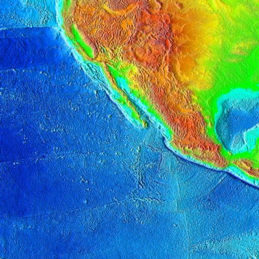
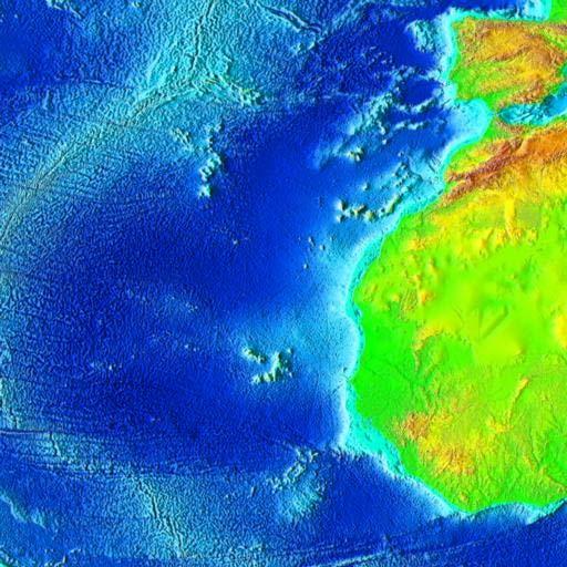
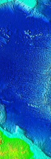
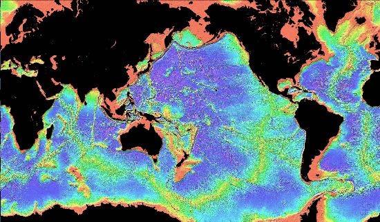
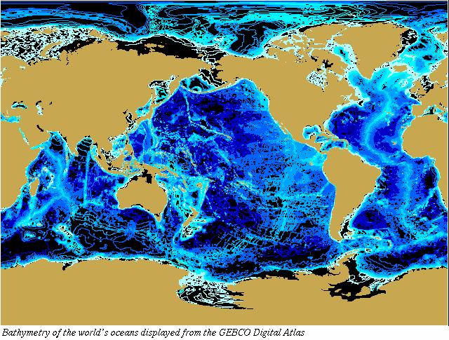
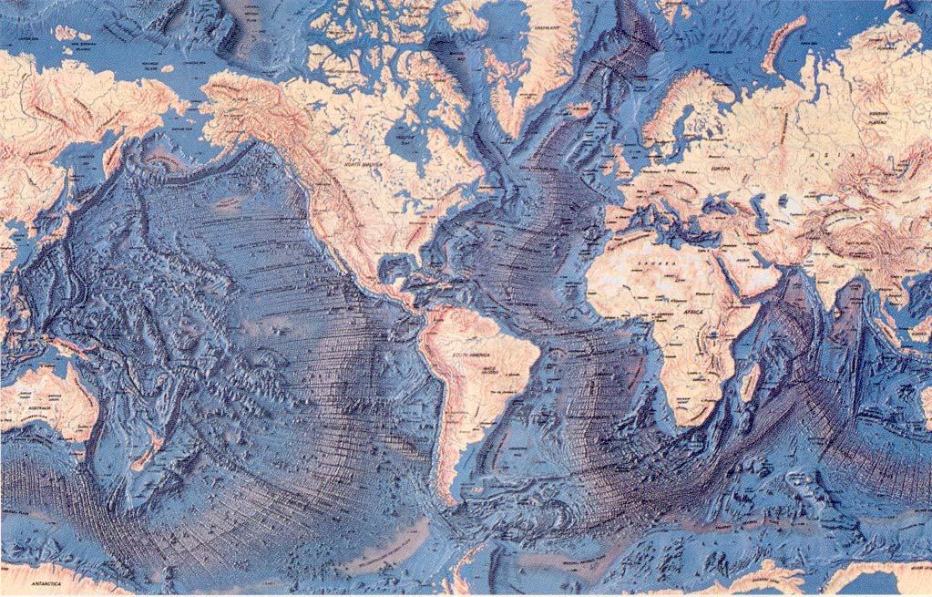
3 This is the relief map of the world. If you go to the URL below, you will be able to click on any of the grids here to view enlarged versions of them.
4
5
6
7
8
 Continental platforms (18.9%) Ocean ridges (22.1%) Ocean basin floors (29.8%) O C E A 0.")
9 Continental rise (3.8%) Island arcs, trenches, guyots etc. (3.7%) Continental shelf and slope (11.4%) L ( A N D 29.2 %) Continental platforms (18.9%) Ocean ridges (22.1%) Ocean basin floors (29.8%) O C E A 0.8% ) N (7 Continental mountains (10.3%)
10 Height or Depth (Km) relative to MSL % 1.1% % 0.9% 0.05% Proportion of Earth s Surface 10% 20% Depth segments (top scale) 2.2% 4.5% 20.8% 8.5% 3.1% 6.0% (bottom scale) 14.9% 22.5% 15.0% Cumulative curve 0% 40% 80% Proportion of Earth s Surface (cumulative)
11
12
13
14
15
16
17
18
19
20

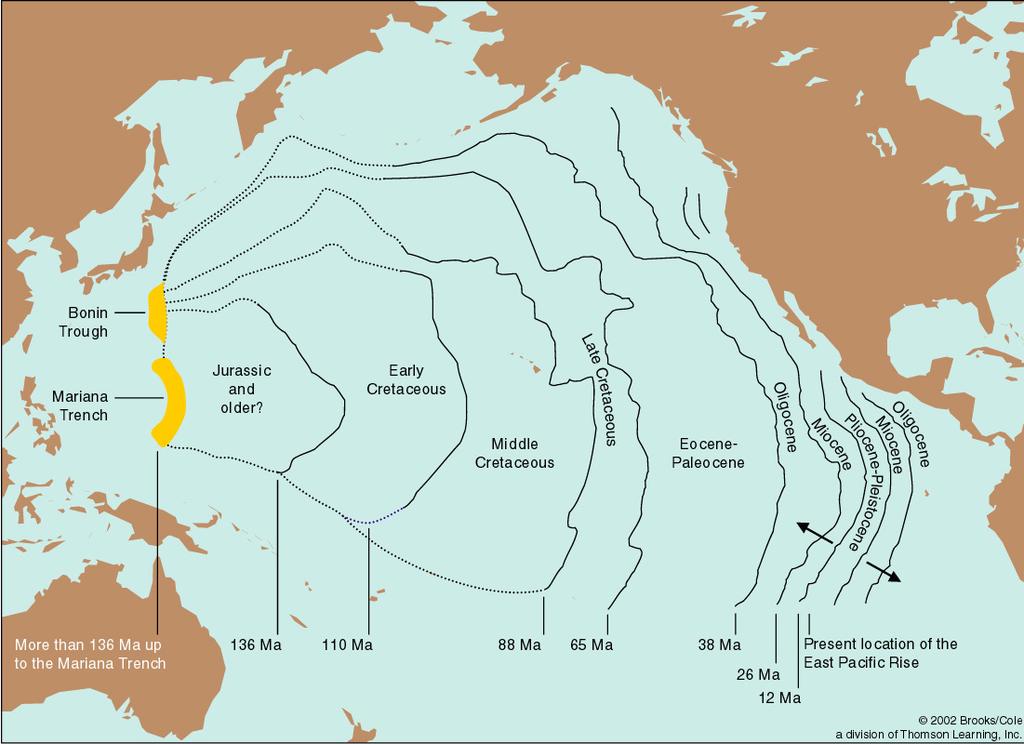
21 An ocean of superlatives, the Pacific covers about a third of the globe. This largest of oceans includes the world's deepest point, Challenger Deep, which plunges farther below the sea's surface than the tallest mountain, Everest, rises above it.

22 Just more than half the size of the Pacific, the Atlantic is the second largest ocean. Its central underwater mountain range, the Mid-Atlantic Ridge, was not directly seen or explored until 1973.

23

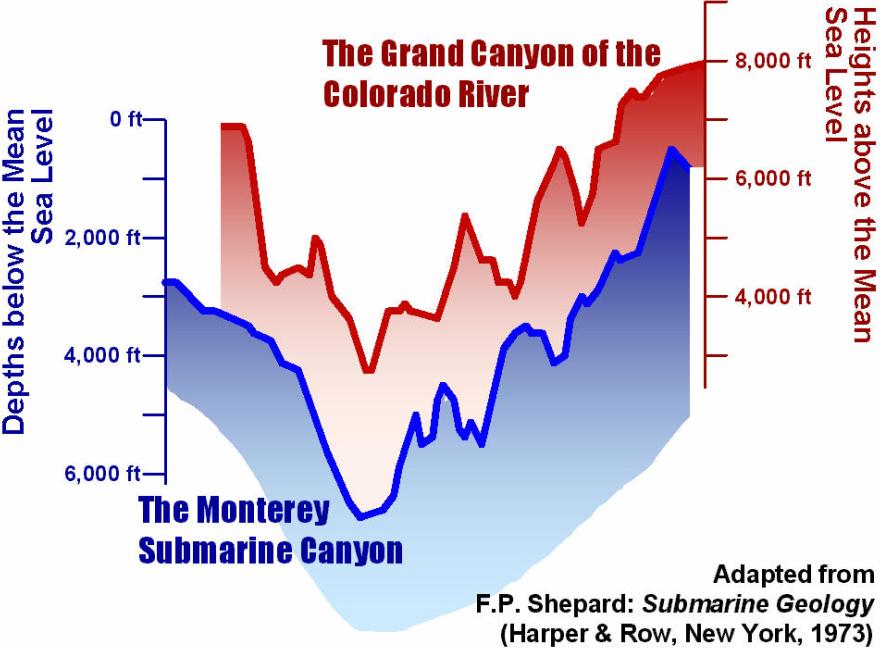
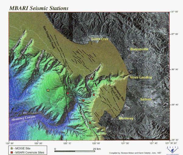
24 A view of the Monterey Canyon

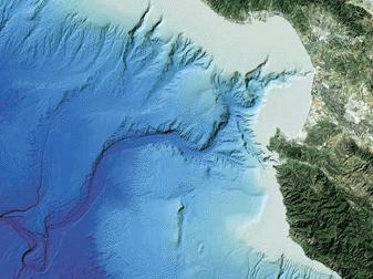
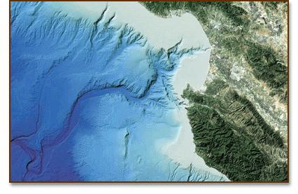
25 Monterey Canyon another view

26 The Indian Ocean is the world's third largest, making up one-fifth of earth's total ocean area. The Mid- Indian Ridge constitutes an area of seafloor spreading.

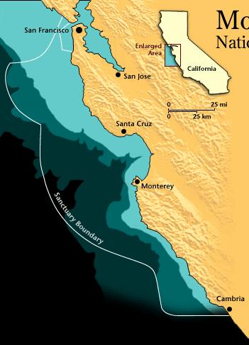
27 Cold waters off Antarctica, sometimes called the Southern Ocean, form a distinct ecosystem. Vast stocks of shrimplike krill support, directly or indirectly, virtually all Antarctic wildlife.

28 The world's widest continental shelves create relatively shallow seas around the rim of the Arctic. Below pack ice, pushed by wind and currents, ocean floor depths plunge almost three miles.

29 Perspective is looking northeast from the Pacific Ocean towards Los Angeles and Palos Verdes.
 and deep sea")
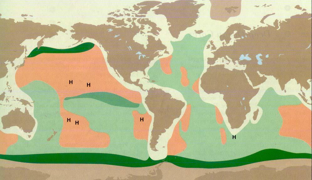
30 The world distribution of continental rises ( ) and deep sea trenches ( )
31
32
33

34 Monterey Bay Regional Geographic Reference Map
35
36
37
38
39

40 USGS
.")
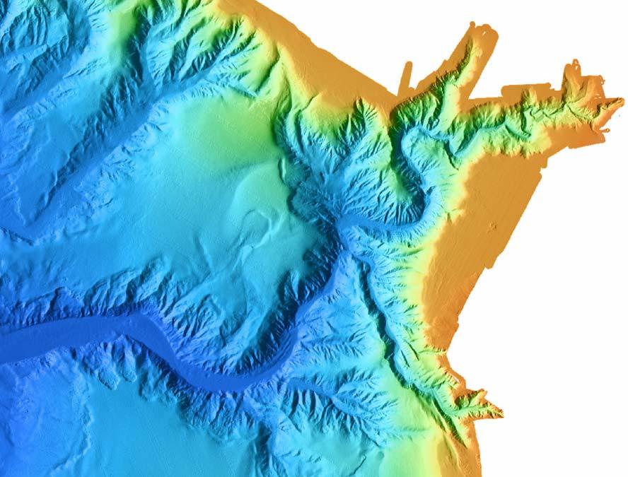
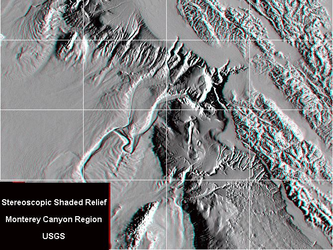
41 In this image, the viewer has been positioned to the west of the image at an elevation angle of 25º above the ocean (65º from directly above). The topographic relationships between the on-land mountains, ocean shelf, slope and basin are easily seen in this image.

42 This is the same as the previous image, but with color coded bathymetry.
43
44
45 The beach Material is typically classified according mm Boulder to diameter mm Cobble mm 2 1 mm Pebble Granule mm Sand mm Silt mm Clay

46 Distribution and thickness of world s sediments Physiographic Province

47 Sahara Desert, Africa Dull opaque surfaces due to erosion from high speed winds. Desert sands tend to have a wider assortment of grain sizes. On the other hand, sand found near water has its sediments constantly sifted, thus depositing grains that are nearly the same size.


48 Current Velocity (cm/s) Current velocity and grain size determine erosion, transportation and deposition of sediments Transportation Erosion and Transportation Deposition Grain Diameter (mm)

49 Punalulu, Hawaii The sand of Hawaii's black beaches is obsidian - volcanic glass created by magma that flowed to the sea and then cooled rapidly. It was eventually reduced to bits of fine black sand by water and waves.

50 Lifuka Island, Tonga, SW Pacific Remains of tiny sea animals called crinoids (sea lily) make up part of the sand in this area of the South Pacific. These stony disks which are calcified, wheel-like plates, fall in large numbers to the bottom of the ocean.

51 Seven Mile Beach, Dongara, Australia This area, teaming with life from the Indian Ocean, reveals many small corals and shells. In addition, this sand is predominantly made up of some very immature bivalve shells. Most unusual however, are the three-axial, iciclelike sponge points.

52 Ryukyu Islands, Japan Some of the southern Japanese islands are famous for their beautiful "star sand." These grains are the shells of microscopic, single-celled animals that are found in abundance throughout our oceans.

53 Saint-Tropez, French Riviera The reefs along this shoreline support many different animals whose shells are tossed onto the beach by the waves. This sample shows cone-like mollusks, and tubular mollusks. Below these you can see the horn of a marine ram. You can also see some black and gold mica crystals along with a sponge or sea-urchin spine.
54 Type/ Source Terrigenous Erosion of land, volcanic eruptions, blown dust Biogenous Accumulation of shells of marine organisms Quartz sand, clays, estuarine mud Calcareous and siliceous oozes, corals Hydrogenous (a) Precipitate Precipitation of minerals dissolved in water Residue from the evaporation of seawater Cosmogenous Dust from space, meteorite debris Limestones, phosphate deposits (b) Evaporate Salt, Gypsum/ anhydrite Tektite spherules, glassy nodules Examples Distribution Dominant on continental margins, abyssal plains, polar ocean floors Dominant on deepocean floor (siliceous ooze below ~5 km) Present with the other, more dominant sediments Present with the other, more dominant sediments Mixed in very small proportion Relative abundance ~45% ~55% < 1% Traces (< 0.01%)
55 The distribution of various kinds of seafloor sediments
56

57 Continental shelf sediments, as function of latitude
are unconsolidated particulate materials that either precipitate from or are deposited by a fluid (e.g., water, wind);
;") Sediments... are unconsolidated particulate materials that either precipitate from or are deposited by a fluid (e.g., water, wind); provide information about the past depositional environments and climatic
Sediments... are unconsolidated particulate materials that either precipitate from or are deposited by a fluid (e.g., water, wind); provide information about the past depositional environments and climatic
Marine Sediments. Introductory Oceanography. Ray Rector: Instructor
 Marine Sediments Introductory Oceanography Ray Rector: Instructor Ocean Basins are Vast Sinks for Huge Amounts of Sediment from Numerous Different Sources Four Major Types of Seafloor Sediments 1. Lithogenous
Earth s Seafloors. Ocean Basins and Continental Margins. Introductory Oceanography Ray Rector - Instructor
 Earth s Seafloors Ocean Basins and Continental Margins Introductory Oceanography Ray Rector - Instructor OCEAN BASINS and CONTINENTAL PLATFORMS Key Concepts I. Earth s rocky surface covered by of two types
Seas. A sea is a part of an ocean that is nearly surrounded by water. The Mediterranean, Arctic and Black Sea are really part of the Atlantic Ocean.
 Exploring the Ocean Since ancient times people have studied the ocean such as waters and ocean floor It provides food and services, and serves as a route for trade and travel The World s Oceans 71% of
Foundations of Earth Science, 6e Lutgens, Tarbuck, & Tasa
 Foundations of Earth Science, 6e Lutgens, Tarbuck, & Tasa Oceans: The Last Frontier Foundations, 6e - Chapter 9 Stan Hatfield Southwestern Illinois College The vast world ocean Earth is often referred
14.2 Ocean Floor Features Mapping the Ocean Floor
 14.2 Ocean Floor Features Mapping the Ocean Floor The ocean floor regions are the continental margins, the ocean basin floor, and the mid-ocean ridge. 14.2 Ocean Floor Features Continental Margins A continental
Oceanography is the scientific study of oceans Oceans make up over 70% of the Earth s surface
 Oceanography Oceanography is the scientific study of oceans Oceans make up over 70% of the Earth s surface An ocean must be large and have features which set it apart from other oceans (currents, water
Earth / Environmental Science. Ch. 14 THE OCEAN FLOOR
 Earth / Environmental Science Ch. 14 THE OCEAN FLOOR The Blue Planet Nearly 70% of the Earth s surface is covered by the global ocean It was not until the 1800s that the ocean became an important focus
Lecture Outlines PowerPoint. Chapter 13 Earth Science 11e Tarbuck/Lutgens
 Lecture Outlines PowerPoint Chapter 13 Earth Science 11e Tarbuck/Lutgens 2006 Pearson Prentice Hall This work is protected by United States copyright laws and is provided solely for the use of instructors
Reading Material. See class website. Sediments, from Oceanography M.G. Gross, Prentice-Hall
 Reading Material See class website Sediments, from Oceanography M.G. Gross, Prentice-Hall Materials filling ocean basins Dissolved chemicals especially from rivers and mid-ocean ridges (volcanic eruptions)
The Ocean Floor Chapter 14. Essentials of Geology, 8e. Stan Hatfield and Ken Pinzke Southwestern Illinois College
 The Ocean Floor Chapter 14 Essentials of Geology, 8e Stan Hatfield and Ken Pinzke Southwestern Illinois College The vast world ocean Earth is often referred to as the water planet 71% of Earth s surface
Directed Reading. Section: The Water Planet. surface is called the a. Earth s ocean. b. Pacific Ocean. c. salt-water ocean. d. global ocean.
 Skills Worksheet Directed Reading Section: The Water Planet 1. The body of salt water covering nearly three-quarters of the Earth s surface is called the a. Earth s ocean. b. Pacific Ocean. c. salt-water
ARE YOU READY TO THINK? Look at the first slide THINK PAIR SHARE!
 ARE YOU READY TO THINK? Look at the first slide THINK PAIR SHARE! WHAT PROMINENT FEATURE CAN YOU IDENTIFY IN THIS PICTURE? What do you think the different colors represent? Who might find such a picture
Question. What caused the recent explosive eruptions of hot ash and gas at Kilauea s Halema uma u crater:
 OCN 201 Deep Sea Sediments Question What caused the recent explosive eruptions of hot ash and gas at Kilauea s Halema uma u crater: A. The interaction of lava with seawater B. Drainage of the lava lake
Chapter 9 Lecture Outline. Oceans: The Last Frontier
 Chapter 9 Lecture Outline Oceans: The Last Frontier The Vast World Ocean Earth is referred to as the blue planet 71% of Earth s surface is oceans and marginal seas Continents and islands comprise the remaining
Marine Sediments EPSS15 Spring 2017 Lab 4
 Marine Sediments EPSS15 Spring 2017 Lab 4 Why Sediments? Record of Earth s history - Tectonic plate movement - Past changes in climate - Ancient ocean circulation currents - Cataclysmic events 1 Classification
The Marine Environment
 The Marine Environment SECTION 16.1 Shoreline Features In your textbook, read about erosional landforms, beaches, estuaries, longshore currents, and rip currents. For each statement below, write or. 1.
Small area of the ocean that is partially surrounded by land. The Ocean Basins. Three Major Oceans. Three Major Oceans. What is a SEA?
 The Ocean Basins How Deep is the Ocean? 1 2 Three Major Oceans Three Major Oceans Pacific Atlantic the shallowest ocean (3.3km average depth) Indian second shallowest ocean (3.8km average depth) Pacific
Ocean Floor. Continental Margins. Divided into 3 major regions. Continental Margins. Ocean Basins. Mid-Ocean Ridges. Include:
 Ocean Floor Divided into 3 major regions Continental Margins Ocean Basins Mid-Ocean Ridges Continental Margins Include: Continental Shelves Continental Slopes Continental Rise 1 Continental Shelves Part
The Ocean Floor Earth Science, 13e Chapter 13
 The Ocean Floor Earth Science, 13e Chapter 13 Stanley C. Hatfield Southwestern Illinois College The vast world ocean Earth is often referred to as the blue planet Seventy-one percent of Earth s surface
The Marine Environment
 The Marine Environment SECTION 16.1 Shoreline Features In your textbook, read about erosional landforms, beaches, estuaries, longshore currents, and rip currents. For each statement below, write true or
Chapter 14: The Ocean Floor
 Chapter 14: The Ocean Floor Section 1: The Vast World Ocean I. The Blue Planet Group # II. Geography of the Oceans Group # III. Mapping the Ocean Floor Group # A. Sonar Group # B. Satellites Group # C.
Section 14.1 The Vast World Ocean This section discusses how much of Earth is covered by water and how that water is studied.
 Section 14.1 The Vast World Ocean This section discusses how much of Earth is covered by water and how that water is studied. Reading Strategy Building Vocabulary As you read the section, define each term
The Sea Floor. Chapter 2
 The Sea Floor Chapter 2 Geography of the Ocean Basins World ocean is the predominant feature on the Earth in total area Northern Hemisphere = 61% of the total area is ocean. Southern Hemisphere = about
MARINE GEOLOGY & GEOGRAPHY
 MARINE GEOLOGY & GEOGRAPHY Bathymetry BATHYMETRY BATHYMETRY THE UNDERWATER EQUIVALENT TO TOPOGRAPHY THE STUDY OF WATER DEPTH A BATHYMETRIC MAP SHOWS FLOOR RELIEF OR TERRAIN AS CONTOUR LINES Bathymetry
Bell Ringer. water cycle? gaseous water (water vapor)? How do you know? 1. What are the five components of the
? How do you know? 1. What are the five components of the") Bell Ringer 1. What are the five components of the water cycle? 2. Are clouds composed of liquid water or gaseous water (water vapor)? How do you know? 3. How are glaciers formed? Salt Water - Oceans Characteristics
Bell Ringer 1. What are the five components of the water cycle? 2. Are clouds composed of liquid water or gaseous water (water vapor)? How do you know? 3. How are glaciers formed? Salt Water - Oceans Characteristics
Ocean Basins, Bathymetry and Sea Levels
 Ocean Basins, Bathymetry and Sea Levels Chapter 4 Please read chapter 5: sediments for next class and start chapter 6 on seawater for Thursday Basic concepts in Chapter 4 Bathymetry the measurement of
Lecture 05: Ocean Basins. Hypsometric Curve. Consider Ocean Basins: What is the elevation of Chambana?
 Lecture 05: Ocean Basins 1 Hypsometric Curve What is the elevation of Chambana? Shows distribution of surface relative to sea level ~67% below sea level Mean ocean depth ~ -3.7 km (well below sea level)
The surface of the ocean floor is as varied as the land. The five major oceans, from largest to smallest, are
 11.1 Ocean Basins The surface of the ocean floor is as varied as the land. The five major oceans, from largest to smallest, are w the Pacific w the Atlantic w the Indian w the Southern w the Arctic The
Map shows 3 main features of ocean floor
 Map shows 3 main features of ocean floor 2017 Pearson Education, Inc. Chapter 3 Marine Provinces 2017 Pearson Education, Inc. 1 Chapter 3 Overview The study of bathymetry determines ocean depths and ocean
Chapter 02 The Sea Floor
 Chapter 02 The Sea Floor Multiple Choice Questions 1. One of the following is not one of the world's major ocean basins: A. Atlantic Ocean B. Arctic Ocean C. Indian Ocean D. Antarctic Ocean E. Pacific
Chapter Overview. Bathymetry. Measuring Bathymetry. Measuring Bathymetry
 CHAPTER 3 Marine Provinces Chapter Overview The study of bathymetry determines ocean depths and ocean floor topography. Echo sounding and satellites are efficient bathymetric tools. Most ocean floor features
Bathymetry Measures the vertical distance from the ocean surface to mountains, valleys, plains, and other sea floor features
 1 2 3 4 5 6 7 8 9 10 11 CHAPTER 3 Marine Provinces Chapter Overview The study of bathymetry determines ocean depths and ocean floor topography. Echo sounding and satellites are efficient bathymetric tools.
24. Ocean Basins p
 24. Ocean Basins p. 350-372 Background The majority of the planet is covered by ocean- about %. So the majority of the Earth s crust is. This crust is hidden from view beneath the water so it is not as
Ocean Scavenger Hunt. Materials: pencil study notes timer. Directions:
 Ocean Scavenger Hunt Materials: pencil study notes timer Directions: 1. Each student receives a copy of the scavenger hunt, placed upside down on their desk. 2. Explain to students that they will scavenge
Earth Science Lesson Plan Quarter 2, Week 10, Day 1
 Earth Science Lesson Plan Quarter 2, Week 10, Day 1 Outcomes for Today Standard Focus: PREPARE 1. Background knowledge necessary for today s reading. Beaches are created by the actions of waves, tides,
OCN 201: Deep-Sea Sediments
 OCN 201: Deep-Sea Sediments Eric Heinen De Carlo, F2011 Where is the Sediment? Continental Margins: 87% (covers ~21% of ocean area) Deep-ocean floor: 13% ~21% ~87% Sediment Deposition Rates (time to deposit
Unit 1: Water Systems on Earth Chapter 2
 Unit 1: Water Systems on Earth Chapter 2 Create a mind map with the driving question, Why are Oceans Important? Remember: Why are oceans so important? Why are oceans so important? Primary water source
Earth s Continents and Seafloors. GEOL100 Physical Geology Ray Rector - Instructor
 Earth s Continents and Seafloors GEOL100 Physical Geology Ray Rector - Instructor OCEAN BASINS and CONTINENTAL PLATFORMS Key Concepts I. Earth s rocky surface covered by of two types of crust Dense, thin,
Processes affecting continental shelves
 Marine Sediments Continental Shelves Processes affecting continental shelves 1. Glaciation 2. Sea-level change (±130 m during continental glaciation) 3. Waves and currents 4. Sedimentation 5. Carbonate
Marine Science and Oceanography
 Marine Science and Oceanography Marine geology- study of the ocean floor Physical oceanography- study of waves, currents, and tides Marine biology study of nature and distribution of marine organisms Chemical
TAKE HOME EXAM 8R - Geology
 Name Period Date TAKE HOME EXAM 8R - Geology PART 1 - Multiple Choice 1. A volcanic cone made up of alternating layers of lava and rock particles is a cone. a. cinder b. lava c. shield d. composite 2.
Chapter 4 Marine Sediments
 Chapter 4 Marine Sediments Chapter Overview Marine sediments are important because contain a record of Earth history & provide clues to understand it Marine organism distribution Ocean floor movements
EPSS 15 Fall 2017 Introduction to Oceanography. Marine Sediments
 EPSS 15 Fall 2017 Introduction to Oceanography Marine Sediments INTRODUCTION There are two basic methods used for classification of marine sediments: genetic and descriptive. Genetic classifications distinguish
Unit 4 - Water. Earth s Interior. Earth s Interior. Continental Drift. Continental Drift. Continental Drift. Crust. Mantle. Core.
 Unit 4 - Water How did the oceans form? What special adaptations do saltwater organisms have? Where does our water come from? How do humans affect the Earth s water? Crust Rigid outer shell of Earth Oceanic
MARINE GEOLOGY & GEOGRAPHY
 MARINE GEOLOGY MARINE GEOLOGY & GEOGRAPHY Marine Geology 4 LAYERS OF THE EARTH CRUST THICKNESS: VARIES BETWEEN OCEAN & CONTINENTS 5-40 KM STATE: SOLID ELEMENTS: SILICON, ALUMINUM, CALCIUM, SODIUM, POTASSIUM
Actual bathymetry (with vertical exaggeration) Geometry of the ocean 1/17/2018. Patterns and observations? Patterns and observations?
 Geometry of the ocean 1/17/2018. Patterns and observations? Patterns and observations?") Patterns and observations? Patterns and observations? Observations? Patterns? Observations? Patterns? Geometry of the ocean Actual bathymetry (with vertical exaggeration) Continental Continental Basin
Patterns and observations? Patterns and observations? Observations? Patterns? Observations? Patterns? Geometry of the ocean Actual bathymetry (with vertical exaggeration) Continental Continental Basin
OCN 201 Physiography of the Seafloor
 OCN 201 Physiography of the Seafloor Hypsometric Curve for Earth s solid surface Note histogram Hypsometric curve of Earth shows two modes. Hypsometric curve of Venus shows only one! Why? Ocean Depth vs.
Lecture Outline Wednesday - Friday February 14-16, 2018
 Lecture Outline Wednesday - Friday February 14-16, 2018 Quiz 2 scheduled for Friday Feb 23 (Interlude B, Chapters 6,7) Questions? Chapter 6 Pages of the Past: Sedimentary Rocks Key Points for today Be
GEOLOGY MEDIA SUITE Chapter 5
 UNDERSTANDING EARTH, SIXTH EDITION GROTZINGER JORDAN GEOLOGY MEDIA SUITE Chapter 5 Sedimentation Rocks Formed by Surface Processes 2010 W.H. Freeman and Company Mineralogy of sandstones Key Figure 5.12
Sediment and sedimentary rocks Sediment
 Sediment and sedimentary rocks Sediment From sediments to sedimentary rocks (transportation, deposition, preservation and lithification) Types of sedimentary rocks (clastic, chemical and organic) Sedimentary
Physiography Ocean Provinces p. 1 Dimensions p. 1 Physiographic Provinces p. 2 Continental Margin Province p. 2 Deep-Ocean Basin Province p.
 Physiography Ocean Provinces p. 1 Dimensions p. 1 Physiographic Provinces p. 2 Continental Margin Province p. 2 Deep-Ocean Basin Province p. 2 Mid-Ocean Ridge Province p. 3 Benthic and Pelagic Provinces
Plate Tectonics. Continental Drift Sea Floor Spreading Plate Boundaries
 Plate Tectonics Continental Drift Sea Floor Spreading Plate Boundaries Continental Drift 1915, Alfred Wegener - Pangea hypothesis: suggested Earth s continents were part of a large super-continent 200
Lecture Marine Provinces
 Lecture Marine Provinces Measuring bathymetry Ocean depths and topography of ocean floor Sounding Rope/wire with heavy weight Known as lead lining Echo sounding Reflection of sound signals 1925 German
OCN 201 Physiography of the Seafloor
 OCN 201 Physiography of the Seafloor 1 Ocean Depth versus Continental Height Why do we have dry land? Solid surface of Earth is dominated by two levels: Land with a mean elevation of +840 m (29% of Earth
A) B) C) D) 4. Which diagram below best represents the pattern of magnetic orientation in the seafloor on the west (left) side of the ocean ridge?
 B) C) D) 4. Which diagram below best represents the pattern of magnetic orientation in the seafloor on the west (left) side of the ocean ridge?") 1. Crustal formation, which may cause the widening of an ocean, is most likely occurring at the boundary between the A) African Plate and the Eurasian Plate B) Pacific Plate and the Philippine Plate C)
1. Crustal formation, which may cause the widening of an ocean, is most likely occurring at the boundary between the A) African Plate and the Eurasian Plate B) Pacific Plate and the Philippine Plate C)
Understanding The Seafloor. Dr. Frank R. Hall. Resources for pictures, etc. used in this presentation
 Slide 1 Understanding The Seafloor Dr. Frank R. Hall Geological Oceanographer University of New Orleans New Orleans, LA 2003 This is a presentation prepared in the Summer 2003 for the Gulf Coast COSSEE
6th Grade Science Sample Assessment Items S6E3c.
 Composition 6th Grade Science Sample Assessment Items Ocean water differs from freshwater in that it has. A. a lower temperature B. a higher temperature C. a higher concentration of silicon dioxide D.
Lecture 26: Marine Geology Read: Chapter 21 Homework due December 3
 Learning Objectives (LO) Lecture 26: Marine Geology Read: Chapter 21 Homework due December 3 What we ll learn today:! 1. Describe the world s five oceans! 2. Understand patterns of ocean circulation! 3.
CHAPTER 3 Ocean Basins
 Review: What Drives Plate Motions: (1) Density vs. Gravity: causes oceanic crust to sink in subduction zones, causes crust to extend at spreading ridges (called ridge push, but the ridge is not pushing,
Almost of Earth is covered by water. On a map, the continents appear as huge islands surrounded by a vast global ocean.
 Earth s Oceans & Ocean Floor Date: Feelin Blue What are Earth s five main oceans? Almost of Earth is covered by water. On a map, the continents appear as huge islands surrounded by a vast global ocean.
Marine Sediments Chapter Four Chapter Overview Marine Sediments Approaching the bottom (Alvin) Marine Sediments Classification of Marine Sediments
 Marine Sediments Classification of Marine Sediments") 1 2 3 4 5 6 7 8 9 10 11 Marine Sediments Chapter Four Chapter Overview Marine sediments contain a record of Earth history. Marine sediments provide many important resources. Marine sediments have origins
1 2 3 4 5 6 7 8 9 10 11 Marine Sediments Chapter Four Chapter Overview Marine sediments contain a record of Earth history. Marine sediments provide many important resources. Marine sediments have origins
Learning Outcomes: Logistics: Classification System: bold Metamorphic Igneous Sedimentary Sedimentary rock classification schemes.
 Oceanography Marine rocks Learning Outcomes: Classify rocks into one of the three main categories: sedimentary, igneous, and metamorphic. Classify marine sedimentary rocks into a more detailed classification
Question: What is the primary reason for the great abundance of fish along the Peruvian coast?
 Buzzer Question # 1 Question Type: toss-up Question Format: Multiple Choice Category: Biology What is the primary reason for the great abundance of fish along the Peruvian coast? Answer W: upwelling Answer
Laboratory#6 Sediment Particle Size Distribution and Turbidity Flows
 Laboratory#6 Sediment Particle Size Distribution and Turbidity Flows Although this laboratory will pertain to oceanic sediments similar processes can also be observed on land and other aquatic systems
WHAT IS THE EARTH MADE OF? LITHOSPHERE AND HYDROSPHERE
 UNIT 8 WHAT IS THE EARTH MADE OF? LITHOSPHERE AND HYDROSPHERE TABLE OF CONTENTS 1 THE STRUCTURE OF THE EARTH... 2 2 THE FORMATION OF THE RELIEF: INTERNAL AND EXTERNAL FORCES.... 2 2.1 Internal forces:
2/16/2014. Chapter Overview. Marine Sediments. Approaching the bottom (Alvin) Classification of Marine Sediments. Marine Sediments
 Classification of Marine Sediments. Marine Sediments") Chapter Overview Marine sediments contain a record of Earth history. Marine sediments provide many important resources. Marine sediments have origins from a variety of sources. Marine Sediments Chapter
Chapter Overview Marine sediments contain a record of Earth history. Marine sediments provide many important resources. Marine sediments have origins from a variety of sources. Marine Sediments Chapter
Plate Tectonics 3. Where Does All the Extra Crust Go?
 Plate Tectonics 3 Where Does All the Extra Crust Go? Unless otherwise noted the artwork and photographs in this slide show are original and by Burt Carter. Permission is granted to use them for non-commercial,
Lab 7: Sedimentary Structures
 Name: Lab 7: Sedimentary Structures Sedimentary rocks account for a negligibly small fraction of Earth s mass, yet they are commonly encountered because the processes that form them are ubiquitous in the
Chapter Two. Figure 02_02. Geography of the Ocean Basins. The Sea Floor
 Chapter Two The Sea Floor Geography of the Ocean Basins Figure 02_02 The world ocean is the predominant feature on the Earth in total area. In the Northern Hemisphere, 61% of the total area is ocean. In
Essentials of Oceanography
 Chapter Chapter 1 4 Clickers Lecture Essentials of Oceanography Eleventh Edition Marine Sediments Alan P. Trujillo Harold V. Thurman Chapter Overview Marine sediments contain a record of Earth history.
Map Elements & The 5 Oceans
 Map Elements & The 5 Oceans Latitude and Longitude Longitude lines run north and south. Latitude lines run east and west. The lines measure distances in degrees. Latitude Longitude Where is 0 degrees?
Marine Geosciences / Oceanography Fields and disciplines
 Marine Geosciences / Oceanography Fields and disciplines Marine Geosciences; Oceanography Chemical Oceanography Marine chemistry; marine geochemistry Biological Oceanography Marine biology; marine biogeochemistry
The Major Ocean Basins and Their Features
 Where Submarines Lurk Recent satellite studies and deep-sea mapping programs have revealed in dramatic fashion that the ocean floor is not flat. Indeed, the terrain of the ocean floor surpasses that of
Chapter 1 Section 2. Land, Water, and Climate
 Chapter 1 Section 2 Land, Water, and Climate Vocabulary 1. Landforms- natural features of the Earth s land surface 2. Elevation- height above sea level 3. Relief- changes in height 4. Core- most inner
Oceanography, An Invitation to Marine Science 9e Tom Garrison. Ocean Basins Cengage Learning. All Rights Reserved.
 Oceanography, An Invitation to Marine Science 9e Tom Garrison 4 Ocean Basins Key Concepts Tectonic forces shape the seabed The ocean floor is divided into continental margins and deep ocean basins The
Depositional Environment
 Depositional Environment Sedimentary depositional environment describes the combination of physical, chemical and biological processes associated with the deposition of a particular type of sediment. Types
Questions and Topics
 Plate Tectonics and Continental Drift Questions and Topics 1. What are the theories of Plate Tectonics and Continental Drift? 2. What is the evidence that Continents move? 3. What are the forces that
Seafloor Morphology. Techniques of Investigation. Bathymetry and Sediment Studies
 Seafloor Morphology I f we select a grid for the surface of the earth (i.e. 5 km 2 ) and assign it an average elevation in relation to sea level, we can construct a graph of elevation versus area of the
Science 8 - Water Systems Test - Chapters 1-2
 Science 8 - Water Systems Test - Chapters 1-2 Multiple Choice (30 marks) Identify the choice that best completes the statement or answers the question. 1. What percentage represents the amount of fresh
Chapter 2 Plate Tectonics and the Ocean Floor
 Chapter 2 Plate Tectonics and the Ocean Floor Matching. Match the term or person with the appropriate phrase. You may use each answer once, more than once or not at all. 1. hydrothermal vents A. convergent
The Sea Floor and Its Sediments OCEA 101
 The Sea Floor and Its Sediments OCEA 101 Measuring the depth of the ocean 85BC Posidonius measured depth of Med using rope and rock as ~2000m. Same idea used for next 2000 yrs using graduated ropes and
Oceanography. Oceanography is the study of the deep sea and shallow coastal oceans.
 Oceanography Oceanography is the study of the deep sea and shallow coastal oceans. Studying the Ocean Floor To determine the shape and composition of the ocean floor, scientists use techniques such as
Essential Question: How are the geological features that exist on land similar to the geological features on the ocean floor?
 Essential Question: How are the geological features that exist on land similar to the geological features on the ocean floor? Geography of the Oceans The world ocean can be divided into four main ocean
Ocean facts continued
 Ocean Facts A dynamic system in which many chemical and physical changes take place Formed over millions of years as precipitation filled low areas on Earth called basins and now covers 70% of the Earth
Rocks and the Rock Cycle. Banded Iron Formation
 Rocks and the Rock Cycle Banded Iron Formation Rocks Big rocks into pebbles, Pebbles into sand. I really hold a million, million Rocks here in my hand. Florence Parry Heide How do rocks change? How are
Making Sediments: Biogenic Production, Carbonate Saturation and Sediment Distributions
 Making Sediments: Biogenic Production, Carbonate Saturation and Sediment Distributions OCN 623 Chemical Oceanography Reading: Libes, Chapters 15 and 16 Outline I. Deep sea sedimentation Detrital sediments
water erosion lithosphere Describe the process of erosion and deposition. chemical weathering Dissolving limestone is an example of.
 At one time, there was one large island off the coast of Mississippi and now it is two separate islands. What caused the island to be split into two? water erosion The crust and the top part of the upper
Oceanography Lecture 6
 Oceanography Lecture 6 Defining Boundaries: 3) 1. Review 2. : a. Introduction b. Classification: Size vs.. Origin c. Factors that control sedimentation d. Sedimentation in the Oceans i. Shelf Sedimentation
Ocean Sciences 101 The Marine Environment OCEA 101 THE MARINE ENVIRONMENT MID-TERM EXAM
 OCEA 101 THE MARINE ENVIRONMENT MID-TERM EXAM Part I. Multiple Choice Questions. Choose the one best answer from the list, and write the letter legibly in the blank to the left of the question. 2 points
UNIT 3 GEOLOGY VOCABULARY FLASHCARDS THESE KEY VOCABULARY WORDS AND PHRASES APPEAR ON THE UNIT 3 CBA
 UNIT 3 GEOLOGY VOCABULARY FLASHCARDS THESE KEY VOCABULARY WORDS AND PHRASES APPEAR ON THE UNIT 3 CBA A map that shows Earth s Topographic Map surface topography, which is Earth s shape and features Contour
1. Define habitat and describe how geologic processes influence habitats. Habitats 2. How much of the earth s surface is covered by sea water?
 1. Define habitat and describe how geologic processes influence habitats. Habitats are the natural environments in which organisms live. They are directly shaped by geological processes, which influence
Objectives: Describe the structure of the ocean floor. Describe light intensity and temperature characteristics at different ocean depths.
 Ocean Structure Virtual Lab What are some characteristics of the ocean and the ocean floor? Earths highest mountains, deepest valleys, and flattest plains are found not on land but under the ocean. Beyond
GLG101: What-To-Know List
 Exam 3, Page 1 GLG101: What-To-Know List (Derived from Before You Leave This Page Lists) This list is intended to guide your reading and to help you prepare for the online multiple-choice quizzes. Each
Full file at
 Essentials of Oceanography, 10e (Trujillo/Keller) Chapter 2 Plate Tectonics and the Ocean Floor Match the term with the appropriate phrase. You may use each answer once, more than once or not at all. A)
Oceans I Notes. Oceanography
 Oceans I Notes Outlines on the front table Oceanography the science of our oceans that mixes biology, geology, chemistry, and physics (among other sciences) to unravel the mysteries of our seas. Divisions
Objectives. Vocabulary
 Shoreline Features Objectives Explain how shoreline features are formed and modified by marine processes. Describe the major erosional and depositional shoreline features. Vocabulary wave refraction beach
1. Name at least one place that the mid-atlantic Ridge is exposed above sea level.
 Interpreting Tectonic and Bathymetric Maps. The purpose of this lab is to provide experience interpreting the bathymetry of the seafloor in terms of tectonic and geologic settings and processes. Use the
GEOGRAPHY OCEAN TYPES OF OCEANS Economics Importance of Oceans to Man Relief of the ocean floor Continental Shelf Importance of Continental Shelf
 GEOGRAPHY OCEAN The oceans and seas occupy about 71 per cent of the total earth surface which means that about 29 percent of the earth s surface is occupied by the land. The study of the oceans. The water
USU 1360 TECTONICS / PROCESSES
 USU 1360 TECTONICS / PROCESSES Observe the world map and each enlargement Pacific Northwest Tibet South America Japan 03.00.a1 South Atlantic Arabian Peninsula Observe features near the Pacific Northwest