Intermediary Report - August Prof. Dr. Olivier Francis and Prof. Dr. Tonie Van Dam
|
|
|
- Gabriella Harris
- 6 years ago
- Views:
Transcription

1 ABSOLUTE GRAVITY MEASUREMENTS IN YELLOWSTONE IN SEPTEMBER 2009 Intermediary Report - August 2010 Prof. Dr. Olivier Francis and Prof. Dr. Tonie Van Dam University of Luxembourg Faculty of Sciences, Technology and Communication Campus Kirchberg 6, rue Coudenhove-Kalergi L-1359 Luxembourg Grand-Duché de Luxembourg olivier.francis@uni.lu

2 Foreword This report contains the results of absolute gravity measurements carried out in Yellowstone in September The team includes Prof. Olivier Francis and Prof. Tonie van Dam from the University of Luxembourg in collaboration with Prof. John Wahr from the University of Colorado in Boulder and Dr. David Schmerge, Tim Wilkins and Mark Eckl from the National Oceanic Atmospheric Administration (NOOA). The absolute gravimeter FG5#111 from the National Science Foundation (USA) has been used. The vertical gravity gradient as well as local gravity tied were measured with the spring gravimeter Scintrex from the University of Luxembourg. The objective of this first absolute gravity campaign was to establish two new AG stations in Yellowstone. One was installed in Lake and the other one at Old Faithful (see Figure 1). The National Park guards have been extremely helpful in finding sites meeting the field specifications: safety, as far as possible from human activities and close enough to electric power. The fieldwork presented in this report was funded by the European Center for Geodynamics and Seismology, Luxembourg. Absolute Gravity sites Figure 1. Map of the Yellowstone National Park The absolute gravity observations were performed outdoor in a tent (Figures 2). At Lake, the absolute gravity site is located in a service area. The site itself is located far enough away from the maintenance buildings, dormitories and camping ground to not be disturbed by car 1


.")
3 traffic. The station is located on the tarmac on a parking lot of an official building. Electrical power is taken from the building itself. At Old Faithful, the absolute gravity site is inside a disused water facility area. It has the advantage to be off the main road and protected by a fence. Electrical power is also available on site. Old Faithful Lake Figures 2. Pictures of the absolute gravity sites at Old Faithful and at Lake. Data processing Raw data from the absolute gravimeters consist of vectors of time and position of the falling object during the drops. To obtain the gravity value, a linear equation representing the equation of motion is fit to the raw data including the gravity gradient which has been measured with relative meters. The data processing follows the protocol adopted during absolute gravimeters comparisons at the BIPM in Sèvres (Francis and van Dam, 2003). Geophysical corrections are applied to the raw gravity data: Earth tides using observed tidal parameters, atmospheric pressure effect using a constant admittance, and the polar motion effect using pole positions from IERS. 2
4 The g-soft version 7.0 software from Microg-LaCoste Inc. was used for the processing. All the text outputs as well as some figures are compiled in the annexes of this report for future reference. Vertical Gravity Gradient The vertical gravity gradient was measured with the relative spring gravimeter Scintrex CG5 from the University of Luxembourg at the absolute gravity stations. This gradient is needed to linearize the equation of motion but also to transfer the measured absolute gravity value from the reference height around 1.3 m to the floor. The values of the linear vertical gravity gradient are given in Table 1. Table 1. Vertical gravity gradient measured at the absolute gravity sites Station Vertical Gravity gradient /microgal/cm Standard Deviation /microgal/cm LAKE OLD FAITHFUL Results of the absolute gravity measurements The FG5#111 observations started the Friday 29 th of August until Saturday the 30 th of August in Lake Village. A total of 31 sets of 100 drops (i.e drops) were collected. The FG5 was then moved to Old Faithful where observations were carried out the 30 th and 31 st of August. A total of 50 sets of 100 drops (5000 drops) were collected. The final processed gravity values are displayed in Table 2. All Table 2. Final results of the absolute gravity measurements in the Yellowstone National Park. Site Gravity 1.3m /microgal Standard Deviation /microgal LAKE OLD FAITHFUL Reference Francis O., van Dam T.M., Processing of the Absolute data of the ICAG01, Cahiers du Centre Européen de Géodynamique et de Séismologie, vol.22, 45-48,
5 Financial Report A detailed list of the different expenses for the 2009 gravity campaign in Yellowstone is given in table 3. Olivier Francis had to prepare and collect the absolute gravimeter in Boulder (Colorado) before the campaign. At the end of the campaign before returning the absolute gravimeter, measurements at Table Mountain Geophysical Observatory in Boulder were taken to verify the instrument. Table 3. Absolute gravity campaign in Yellowstone (25/08/2009 to 04/09/2009) Items Details Total Per diem Tonie van Dam 190 * 7 days 1 330,00 Flight ticket 943,75 Per diem Olivier Francis 190 * 10 days 1 900,00 Flight ticket 865,15 Rental car 770,00 Gas 111,41 Equipment shipping TOTAL
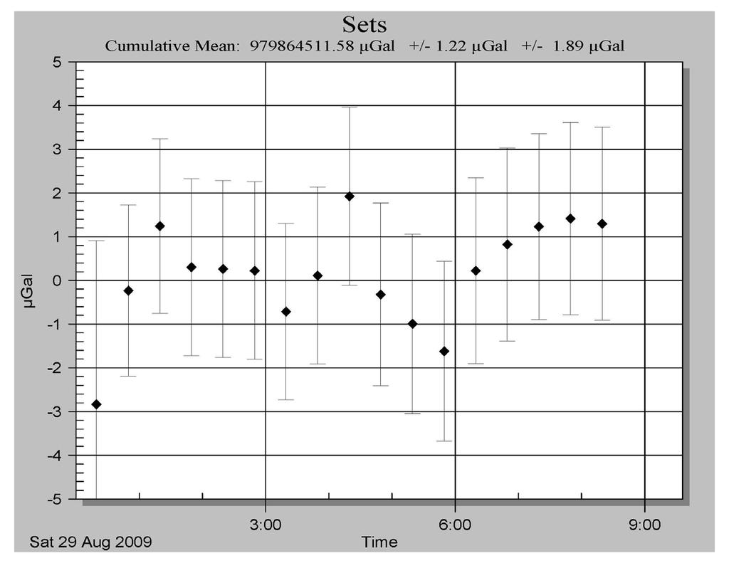
6 ANNEXES STATION: LAKE VILLAGE - YELLOWSTONE City: Lake Village Country: USA Location: Service area Particularity: Situation: Date: August 2009 Remarks: Code number: Latitude: Longitude: Elevation: Gradient: degrees degrees 2398 m µgal/cm Reference height: m m = m Meter: FG5 S/N: 111 Tidal corrections using observed tidal parameters Polar motion correction Air pressure correction X-coordinate arc seconds Nominal air pressure: mbar Y-coordinate arc seconds Barometric admittance factor: 0.3 µgal/mbar Gravity Set gravity mean: Microgal Set std. dev.: 1.22 microgal Number of processed sets: 18 Number of drops per set: 100 Drop interval: Set interval: Nominal/datum height: Author: O. Francis Date: October 30, seconds 30 minutes 1.30 m University of Luxembourg 5
7 Project file Micro-g Solutions g Processing Report File Created: 07/13/10, 14:07:43 Project Name: LA g Acquisition Version: g Processing Version: Company/Institution: Operator: Olivier Francis and David Schmerge Station Data Name: Lake Village Site Code: Yellowstone Lat: Long: Elev: m Setup Height: cm Transfer Height: cm Actual Height: cm Gradient: µgal/cm Nominal Air Pressure: mbar Barometric Admittance Factor: 0.30 Polar Motion Coord: " " Earth Tide (ETGTAB) Selected Potential Filename: C:\Program Files\Micro-g Solutions Inc\gWavefiles\ETCPOT.dat Delta Factor Filename: G:\ABSOLU\DATA\INI\OceanLoad-Lake Village.dff Delta Factors Start Stop Amplitude Phase Term DC Long Q O P K N M S K M M4 Ocean Load ON, Filename: G:\ABSOLU\DATA\INI\OceanLoad-Lake Village.olf Waves: M2 S2 K1 O1 N2 P1 K2 Q1 Mf Mm Ssa Amplitude (µgal): Phase (deg): Instrument Data Meter Type: FG5 Meter S/N: 111 Factory Height: cm Rubidium Frequency: Hz Laser: WEO100 (000000) ID: nm ( 0.48 V) IE: nm ( V) IF: nm ( V) IG: nm ( V) IH: nm ( V) II: nm ( V) IJ: nm ( V) Modulation Frequency: Hz Processing Results 6
8 Date: 08/29/09 Time: 04:04:37 DOY: 241 Year: 2009 Time Offset (D h:m:s): 0 0:0:0 Gravity: µgal Set Scatter: 1.22 µgal Measurement Precision: 0.29 µgal Total Uncertainty: 1.89 µgal Number of Sets Collected: 31 Number of Sets Processed: 18 Set #s Processed: 2,3,4,5,6,7,8,9,10,11,12,13,14,15,16,17,18,19 Number of Sets NOT Processed: 13 Set #s NOT Processed: 1,20,21,22,23,24,25,26,27,28,29,30,31 Number of Drops/Set: 100 Total Drops Accepted: 1737 Total Drops Rejected: 63 Total Fringes Acquired: 700 Fringe Start: 12 Processed Fringes: 608 GuideCard Multiplex: 4 GuideCard Scale Factor: 250 Acquisition Settings Set Interval: 30 min Drop Interval: 10 sec Number of Sets: 48 Number of Drops: 100 Gravity Corrections Earth Tide (ETGTAB): µgal Ocean Load: µgal Polar Motion: µgal Barometric Pressure: 4.22 µgal Transfer Height: 2.26 µgal Reference Xo: µgal Uncertainties Sigma Reject: 3.00 Earth Tide Factor: Average Earth Tide Uncertainty: 0.06 µgal Ocean Load Factor: 0.10 Average Ocean Load Uncertainty: 0.04 µgal Barometric: 1.00 µgal Polar Motion: 0.05 µgal Laser: 0.05 µgal Clock: 0.50 µgal System Type: 1.10 µgal Tidal Swell: 0.00 µgal Water Table: 0.00 µgal Unmodeled: 0.00 µgal System Setup: 1.00 µgal Gradient: 0.02 µgal ( 0.03 µgal/cm) 7
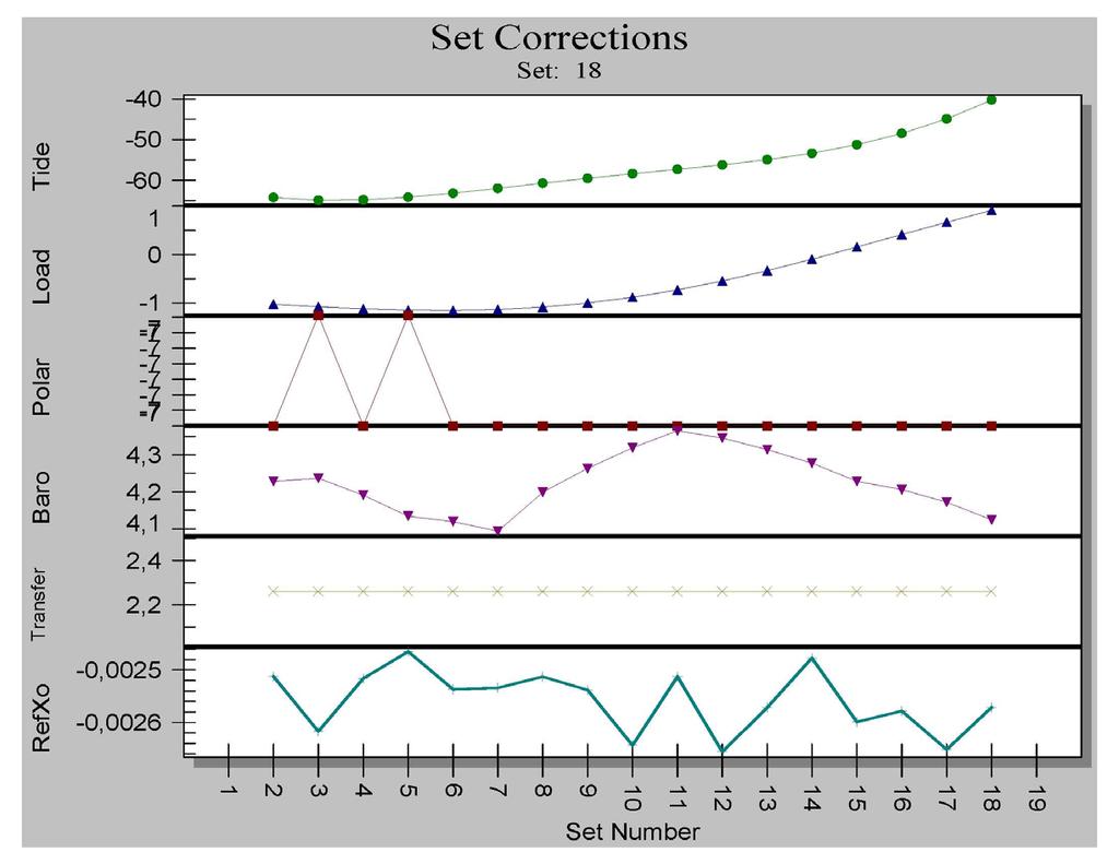
9 Set File Source Data Filename: LA g Acquisition Version: g Processing Version: Set Time DOY Year Gravity Sigma Error Uncert Tide Load Baro Polar Transfer Refxo Temp Pres Accept Reject 2 23:49: :19: :49: :19: :49: :19: :49: :19: :49: :19: :49: :19: :49: :19: :49: :19: :49: :19:
10 9
11 10
12 11
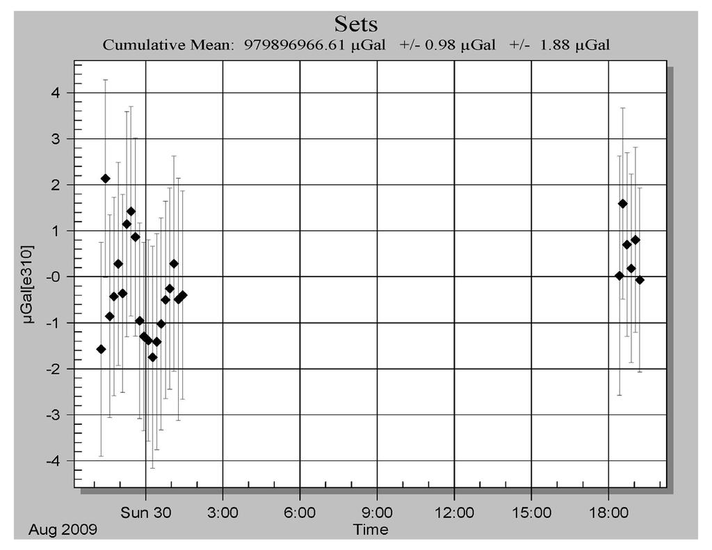
13 STATION: OLD FAITHFUL - YELLOWSTONE City: Old Faithful Country: USA Location: Yellowstone Particularity: Situation: Service area Remarks: Date: August 2009 Code number: Latitude: degrees Longitude: degrees Elevation: 2232 m Gradient: µgal/cm Reference height: m m = m Meter: FG5 S/N: 111 Tidal corrections using observed tidal parameters Polar motion correction Air pressure correction X-coordinate arc seconds Nominal air pressure: mbar Y-coordinate arc seconds Barometric admittance factor: 0.3 µgal/mbar Gravity Set gravity mean: Microgal Set std. dev.: 0.98 microgal Number of sets: 50 Number of drops per set: 100 Drop interval: Set interval: Nominal/datum height: Author: O. Francis Date: October 30, seconds 30 minutes 1.30 m University of Luxembourg 12
14 Project file Micro-g Solutions g Processing Report File Created: 07/13/10, 15:29:00 Project Name: OF2009 g Acquisition Version: g Processing Version: Company/Institution: University of Luxembourg Operator: Olivier Francis and David Schmerge Station Data Name: Old Faith Site Code: Yellowstone Lat: Long: Elev: m Setup Height: cm Transfer Height: cm Actual Height: cm Gradient: µgal/cm Nominal Air Pressure: mbar Barometric Admittance Factor: 0.30 Polar Motion Coord: " " Earth Tide (ETGTAB) Selected Potential Filename: C:\Program Files\Micro-g Solutions Inc\gWavefiles\ETCPOT.dat Delta Factor Filename: G:\ABSOLU\DATA\INI\OceanLoad-Faith-Faith.dff Delta Factors Start Stop Amplitude Phase Term DC Long Q O P K N M S K M M4 Ocean Load ON, Filename: G:\ABSOLU\DATA\INI\OceanLoad-Faith-Faith.olf Waves: M2 S2 K1 O1 N2 P1 K2 Q1 Mf Mm Ssa Amplitude (µgal): Phase (deg): Instrument Data Meter Type: FG5 Meter S/N: 111 Factory Height: cm Rubidium Frequency: Hz Laser: WEO100 (000000) ID: nm ( 0.48 V) IE: nm ( 0.00 V) IF: nm ( V) IG: nm ( V) IH: nm ( V) II: nm ( V) IJ: nm ( V) Modulation Frequency: Hz Processing Results 13
15 Date: 08/30/09 Time: 04:13:33 DOY: 242 Year: 2009 Time Offset (D h:m:s): 0 0:0:0 Gravity: µgal Set Scatter: 0.98 µgal Measurement Precision: 0.19 µgal Total Uncertainty: 1.88 µgal Number of Sets Collected: 50 Number of Sets Processed: 26 Set #s Processed: 1,2,3,4,5,6,7,8,9,10,11,12,13,14,15,16,17,18,19,20,45,46,47,48,49,50 Number of Sets NOT Processed: 24 Set #s NOT Processed: 21,22,23,24,25,26,27,28,29,30,31,32,33,34,35,36,37,38,39,40,41,42,43,44 Number of Drops/Set: 100 Total Drops Accepted: 2404 Total Drops Rejected: 196 Total Fringes Acquired: 700 Fringe Start: 12 Processed Fringes: 608 GuideCard Multiplex: 4 GuideCard Scale Factor: 250 Acquisition Settings Set Interval: 10 min Drop Interval: 5 sec Number of Sets: 50 Number of Drops: 100 Gravity Corrections Earth Tide (ETGTAB): µgal Ocean Load: µgal Polar Motion: µgal Barometric Pressure: 2.44 µgal Transfer Height: µgal Reference Xo: µgal Uncertainties Sigma Reject: 3.00 Earth Tide Factor: Average Earth Tide Uncertainty: 0.03 µgal Ocean Load Factor: 0.10 Average Ocean Load Uncertainty: 0.14 µgal Barometric: 1.00 µgal Polar Motion: 0.05 µgal Laser: 0.05 µgal Clock: 0.50 µgal System Type: 1.10 µgal Tidal Swell: 0.00 µgal Water Table: 0.00 µgal Unmodeled: 0.00 µgal System Setup: 1.00 µgal Gradient: µgal ( 0.03 µgal/cm) 14
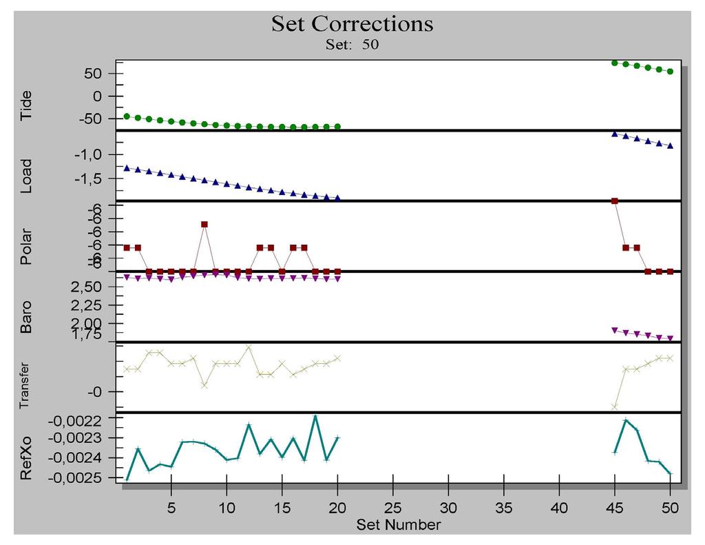
16 Set File Source Data Filename: OF2009 g Acquisition Version: g Processing Version: Set Time DOY Year Gravity Sigma Error Uncert Tide Load Baro Polar Transfer Refxo Temp Pres Accept Reject 1 22:16: :26: :36: :46: :56: :06: :16: :26: :36: :46: :56: :06: :16: :26: :36: :46: :56: :06: :16: :26: :25: :33: :42: :52: :02: :12:
17 16
18 17
19 18
Absolute and Relative Gravity Measurements at the Istituto Nazionale di Ricerca Metrologica (INRIM) of Turin (Italy) in June 2006
 of Turin (Italy) in June 2006") Absolute and Relative Gravity Measurements at the Istituto Nazionale di Ricerca Metrologica (INRIM) of Turin (Italy) in June 2006 Final Report September 2006 Prof. Dr. Olivier Francis University of Luxembourg
Absolute and Relative Gravity Measurements at the Istituto Nazionale di Ricerca Metrologica (INRIM) of Turin (Italy) in June 2006 Final Report September 2006 Prof. Dr. Olivier Francis University of Luxembourg
Final Report. January Prof. Dr. Olivier Francis
 ABSOLUTE AND RELATIVE GRAVITY MEASUREMENTS IN NUUK (GREENLAND) IN JULY 2005 Final Report January 2006 Prof. Dr. Olivier Francis University of Luxembourg Faculty of Sciences, Technology and Communication
ABSOLUTE GRAVITY MEASUREMENTS
 ABSOLUTE GRAVITY MEASUREMENTS AT THE CONRAD OBSERVATORIUM IN AUSTRIA IN JUNE 2012 Final Report August 2012 Prof. Dr. Olivier Francis University of Luxembourg Faculty of Sciences, Technology and Communication
ABSOLUTE GRAVITY MEASUREMENTS IN LOMONOSOV, SAINT-PETERSBURG, RUSSIA
 ABSOLUTE GRAVITY MEASUREMENTS IN LOMONOSOV, SAINT-PETERSBURG, RUSSIA FINAL REPORT NOVEMBER 2004 Prof. Dr. Olivier Francis University of Luxembourg Faculty of Sciences, Technology and Communication Campus
Absolute Gravity Observation at the National Measurement Institute
 Record 2013/30 GeoCat 76733 Absolute Gravity Observation at the National Measurement Institute 18th June 2008 Nicholas Dando, Ray Tracey APPLYING GEOSCIENCE TO AUSTRALIA S MOST IMPORTANT CHALLENGES www.ga.gov.au
RELATIVE GRAVITY MEASUREMENTS
 RELATIVE GRAVITY MEASUREMENTS IN KELLYVILLE AND KANGERLUSSUAQ IN JULY 2013 Final Report June 2015 Prof. Dr. Olivier Francis University of Luxembourg Faculty of Sciences, Technology and Communication Campus
RELATIVE GRAVITY MEASUREMENTS
 RELATIVE GRAVITY MEASUREMENTS IN ILULISSAT IN JULY 2013 Final Report June 2015 Prof. Dr. Olivier Francis University of Luxembourg Faculty of Sciences, Technology and Communication Campus Kirchberg 6, rue
Intercomparison of Relative and Absolute Gravimeters. Olivier FRANCIS
 Intercomparison of Relative and Absolute Gravimeters Olivier FRANCIS The right gravimeter for the right job (signal to be detected) Absolute/relative Stability (accuracy)/precision (repetability) Spatial
Istituto Nazionale di Ricerca Metrologica
 Istituto Nazionale di Ricerca Metrologica G. D Agostino (1), S. Desogus (1), A. Germak (1), C. Origlia (1), D. Quagliotti (1), G. Celli (2) and O. Francis (3) MEASUREMENTS OF THE ACCELERATION DUE TO GRAVITY
FG5 Absolute Gravimeter
 FG5 Absolute Gravimeter Micro-g LaCoste Derek van Westrum, Ph.D. www.microglacoste.com derek@microglacoste.com FG5 Specifications Accuracy: 2 μgal (observed agreement between FG5 instruments) Precision:
To the best of our knowledge, the FG5 gravimeter represents the current state-of-the-art in the measurement of absolute gravity.
 FG5 gravity meter To the best of our knowledge, the FG5 gravimeter represents the current state-of-the-art in the measurement of absolute gravity. American Geophysical Union, EOS Journal Since its introduction
Reservoir Monitoring Using Hybrid Micro-Gravity Measurements in the Takigami Geothermal Field, Central Kyushu, Japan
 Proceedings World Geothermal Congress 2010 Bali, Indonesia, 25-29 April 2010 Reservoir Monitoring Using Hybrid Micro-Gravity Measurements in the Takigami Geothermal Field, Central Kyushu, Japan Jun Nishijima,
ONE YEAR WITH OUR ABSOLUTE GRAVIMETER
 ONE YEAR WITH OUR ABSOLUTE GRAVIMETER Mikael Lilje, Jonas Ågren, Andreas Engfeldt, Per-Anders Olsson Lantmäteriet, Sweden Introduction In Sweden, a new generation of reference systems has been introduced.
Tidal gravity measurements in Southeast Asia revisited.
 Tidal gravity measurements in Southeast Asia revisited. Olivier Francis and Tonie van Dam Geophysics Laboratory Faculty of Science, Technology and Communication University of Luxembourg Luxembourg Olivier.francis@uni.lu
Publication 15_H055. Absolute and Relative Gravity Survey University of Hawai i-manoa and Pier 35 Honolulu, Hawai i. February - March 2015
 GEODETIC SURVEYS DIVISION UNCLASSIFIED 314 Publication 15_H055 Absolute and Relative Gravity Survey University of Hawai i-manoa and Pier 35 Honolulu, Hawai i February - March 2015 UNCLASSIFIED 2. NATIONAL
Istituto Nazionale di Ricerca Metrologica
 Istituto Nazionale di Ricerca Metrologica G. D Agostino, S. Desogus, A. Germak, C. Origlia and D. Quagliotti ABSOLUTE MEASUREMENTS OF THE FREE-FALL ACCELERATION g IN PANTELLERIA (ITALY) T.R. 76 November
Regional Comparison of Absolute Gravimeters SIM.M.G-K1 Key Comparison
 Final Report Consultative Committee on Mass and Related Quantities (CCM) Working Group on Gravimetry (WGG) Regional Comparison of Absolute Gravimeters SIM.M.G-K1 Key Comparison Table Mountain Geophysical
Gravity Monitoring with a Superconducting Gravimeter in Vienna
 1 of 10 2/18/2011 3:30 PM Gravity Monitoring with a Superconducting Gravimeter in Vienna Bruno Meurers Institute of Meteorology and Geophysics, University of Vienna Central Institute of Meteorology and
Absolute gravimetry. Gabriel Strykowski Geodynamics Department DTU-Space (formerly Danish National Space Center)
") Absolute gravimetry by Gabriel Strykowski Geodynamics Department DTU-Space (formerly Danish National Space Center) gs@space.dtu.dk Contents 1. Instrumentation 2. Absolute gravity measurements: applications
Absolute gravimetry by Gabriel Strykowski Geodynamics Department DTU-Space (formerly Danish National Space Center) gs@space.dtu.dk Contents 1. Instrumentation 2. Absolute gravity measurements: applications
ECGN - Development of the European Combined Geodetic Network in Austria
 ECGN - Development of the European Combined Geodetic Network in Austria Diethard Ruess 1, Gelöscht: BEV Dept. Control Survey Abstract Austria takes part in the European Combined Geodetic Network - Project
Results of the Seventh International Comparison of Absolute Gravimeters ICAG-2005 at the Bureau International des Poids et Mesures, Sèvres
 Chapter 7 the Seventh International Comparison of Absolute Gravimeters ICAG-2005 at the Bureau International des Poids et Mesures, Sèvres L. Vitushkin, Z. Jiang, L. Robertsson, M. Becker, O. Francis, A.
Istituto Nazionale di Ricerca Metrologica
 Istituto Nazionale di Ricerca Metrologica G. D Agostino, S. Desogus, A. Germak, C. Origlia and D. Quagliotti ABSOLUTE MEASUREMENTS OF THE FREE-FALL ACCELERATION g IN THE REPUBLIC OF PANAMA T.R. 111 March
Development of a Borehole Gravity Meter for Mining Applications
 Ground and Borehole Geophysical Methods Paper 111 Development of a Borehole Gravity Meter for Mining Applications Seigel, H. O. [1], Nind, C. [1], Lachapelle, R. [1], Chouteau, M. [2], Giroux, B. [2] 1.
Rigorous Combination of Superconducting and Absolute Gravity Measurements with Respect to Instrumental Properties
 Rigorous Combination of Superconducting and Absolute Gravity Measurements with Respect to Instrumental Properties H. Wziontek, R. Falk, H. Wilmes, P. Wolf Bundesamt für Kartographie und Geodäsie (BKG),
Absolute Gravity Measurements at Maitri, Antarctica
 Twenty Third Indian Antarctic Expedition Ministry o f Earth Sciences, Technical Publication No. 21, pp 149-154 Absolute Gravity Measurements at Maitri, Antarctica V.M. Tiwari and M.B.S. Vyghreswara Rao
One Year with Our Absolute Gravimeter
 Mikael LILJE, Jonas ÅGREN, Andreas ENGFELDT and Per-Anders OLSSON, Sweden ABSTRACT In 2006 Lantmäteriet (the National Land Survey of Sweden) bought an absolute gravimeter (Micro-g Lacoste FG5) together
GM 1.4. SEG/Houston 2005 Annual Meeting 639
 storage recovery project in Leyden, Colorado Kristofer Davis *, Yaoguo Li, Michael Batzle, and Bob Raynolds** Center for Gravity, Electrical, and Magnetic Studies, Department of Geophysics, Colorado School
Comparison between measurements with the superconducting gravimeter T020 and the absolute gravimeter FG5-221 at Metsähovi, Finland in
 Comparison between measurements with the superconducting gravimeter T020 and the absolute gravimeter FG5-221 at Metsähovi, Finland in 2003-2012 H. Virtanen,, M. Bilker-Koivula, J. Mäkinen J. Näränen, A.
Hybrid Gravimetry for Optimization Time Lapse Monitoring Data: A case study in Kamojang Geothermal Field
 Proceedings World Geothermal Congress 2015 Melbourne, Australia, 19-25 April 2015 Hybrid Gravimetry for Optimization Time Lapse Monitoring Data: A case study in Kamojang Geothermal Field Yayan Sofyan 1,4,
Gravimetric Tide observation at Lake Nasser Region, Aswan, Egypt
 Gravimetric Tide observation at Lake Nasser Region, Aswan, Egypt R.M. Hassan, E.M. Abdelrahman, A. Tealeb, K.H. Zahran and G. Jentzsch ABSTRACT The LaCoste and Romberg gravimeter D-218 of the National
Status. EUREF TWG Meeting November 8 9, 2004, Praha
 ECGN was initiated by IAG Sub-Commission for Europe EUREF (SC1.3a) and IAG Sub-Commission for Europe of the International Gravity and Geoid Commission (IGGC) with relationship to Joint Research Centre
Application of ECGS to host the direction of the
 Président d honneur: Son Altesse Royale Le Grand Duc Henri Président Secrétaire J-M. Goerens E. Buttini ECGS 19, Rue Josy Welter L-7256 Walferdange http://www.ecgs.lu To the International Association of
A Preliminary Attempt of a Quasi-Geoid for Saudi Arabia
 A Preliminary Attempt of a Quasi-Geoid for Saudi Arabia Saad MOGREN, Saudi Arabia Key words: Geoid, Saudi Arabia, SUMMARY This proposal describes the need to undertake a national geoid (quasi-geoid) model
New Developments in Gravity Applications and Instruments
 P - 144 New Developments in Gravity Applications and Instruments Chris NIND 1 ; Tim NIEBAUER 2, Jeff MACQUEEN 2, Derek VAN WESTRUM 2, Fred KLOPPING 2, Daniel ALIOD 2, Ethan MANN 2, Olivier FRANCIS 3 1.
Search for the Gravitational Absorption Effect Using Spring and Super-conducting Gravimeters during the Total Solar Eclipse of August 11, 1999
 Bulletin d Information de Marees Terrestres (BIM) 138 (2003) 10967 http://www.astro.oma.be/icet/bim/bim138/vanruymbeke2.htm Search for the Gravitational Absorption Effect Using Spring and Super-conducting
European Comparison of Absolute Gravimeters ECAG EURAMET project 1186
 European Comparison of Absolute Gravimeters ECAG-2011 EURAMET project 1186 Final Report of the Regional Key comparison EURAMET.M.G-K1 Olivier Francis*, Henri Baumann * University of Luxembourg Federal
Publ. Astron. Obs. Belgrade No. 91 (2012), REALIZATION OF ETRF2000 AS A NEW TERRESTRIAL REFERENCE FRAME IN REPUBLIC OF SERBIA
, REALIZATION OF ETRF2000 AS A NEW TERRESTRIAL REFERENCE FRAME IN REPUBLIC OF SERBIA") Publ. Astron. Obs. Belgrade No. 91 (2012), 199-206 Contributed paper REALIZATION OF ETRF2000 AS A NEW TERRESTRIAL REFERENCE FRAME IN REPUBLIC OF SERBIA D. BLAGOJEVIĆ and V. VASILIĆ Faculty of Civil Engineering,
Publ. Astron. Obs. Belgrade No. 91 (2012), 199-206 Contributed paper REALIZATION OF ETRF2000 AS A NEW TERRESTRIAL REFERENCE FRAME IN REPUBLIC OF SERBIA D. BLAGOJEVIĆ and V. VASILIĆ Faculty of Civil Engineering,
Gravimètre Quantique Absolu : une utilisation opérationnelle des atomes froids pour la mesure de gravité. Dr. Jean Lautier-Gaud Journée CNFGG
 Gravimètre Quantique Absolu : une utilisation opérationnelle des atomes froids pour la mesure de gravité Dr. Jean Lautier-Gaud Journée CNFGG Outline Brief overview of Muquans Absolute gravimetry with cold
CONTINUOUS GRAVITY MEASUREMENTS FOR RESERVOIR MONITORING. M. Sugihara
 PROCEEDINGS, Twenty-Fourth Workshop on Geothermal Reservoir Engineering Stanford University, Stanford, California, January 25-27, 1999 SGP-TR-162 CONTINUOUS GRAVITY MEASUREMENTS FOR RESERVOIR MONITORING
AGrav - the New International Absolute Gravity Database of BGI and BKG and its Benefit for the Global Geodynamics Project (GGP)
") AGrav - the New International Absolute Gravity Database of BGI and BKG and its Benefit for the Global Geodynamics Project (GGP) H. Wilmes, H. Wziontek, R. Falk, S. Bonvalot To cite this version: H. Wilmes,
AGrav - the New International Absolute Gravity Database of BGI and BKG and its Benefit for the Global Geodynamics Project (GGP) H. Wilmes, H. Wziontek, R. Falk, S. Bonvalot To cite this version: H. Wilmes,
Mount Stromlo Gravity Station Gravimetry at the ANU
 ANU COLLEGE OF SCIENCE RESEARCH SCHOOL OF EARTH SCIENCES Canberra ACT 0200 Australia Mount Stromlo Gravity Station Gravimetry at the ANU Background Terrestrial observing has been conducted at Mount Stromlo
State-of-the-art physical models for calculating atmospheric pressure loading effects
 State-of-the-art physical models for calculating atmospheric pressure loading effects Dudy D. Wijaya, Böhm J., Schindelegger M., Karbon M., Schuh H. Institute of Geodesy and Geophysics, TU Vienna Geodätische
Assessment of atmospheric reductions for terrestrial gravity observations
 Assessment of atmospheric reductions for terrestrial gravity observations 1) 1) M.Abe, C.Kroner, J.Neumeyer, X.D. Chen 2) 1) Deutsches GeoForschungsZentrum (GFZ), Gravity Field and Gravimetry 2) Institute
GPS time series and sea level
 GPS time series and sea level M. Poutanen 1, H. Koivula 1, M. Tervo 1,2, K. Kahma 3, M. Ollikainen 1, H. Virtanen 1 1 Finnish Geodetic Institute, 2 University of Helsinki, 3 Finnish Institute of Marine
or
 PROCEEDINGS, Thirty-Seventh Workshop on Geothermal Reservoir Engineering Stanford University, Stanford, California, January 30 - February 1, 2012 SGP-TR-194 DECLINED MASS TRENDS OF UNBALANCED PRODUCTION
The LIGO Observatory Environment
 LASER INTERFEROMETER GRAVITATIONAL WAVE OBSERVATORY LIGO Laboratory / LIGO Scientific Collaboration LIGO-T010074-00-D 06/28/2001 The LIGO Observatory Environment LIGO Systems Distribution of this document:
Airborne Geophysical Survey Report River Jordan Property
 Airborne Geophysical Survey Report River Jordan Property Prepared for: Inc. September 3, 2009 Precision GeoSurveys Inc. 520-355 Burrard Street, Vancouver, Canada V6C 2G8 www.precisiongeosurveys.com Table
ESTABLISHMENT OF GRAVIMETRIC NETWORK FOR THE AREA OF ZAGREB METRO. D. Markovinović 1, T. Bašić 2
 ESTABLISHMENT OF GRAVIMETRIC NETWORK FOR THE AREA OF ZAGREB METRO D. Markovinović 1, T. Bašić 2 1 University of Zagreb, Faculty of Geodesy, Kaciceva 26, 10 000 Zagreb, Croatia, e-mail: danko.markovinovic@geof.hr
HIMALAYAN AIRBORNE GRAVITY AND GEOID OF NEPAL
 Mt. Everest HIMALAYAN AIRBORNE GRAVITY AND GEOID OF NEPAL -Niraj Manandhar Head, Geodetic Survey Branch Survey Department, Geodetic Survey Branch Project Background Air Borne Gravity Survey Project was
BUREAU INTERNATIONAL DES POIDS ET MESURES
 BUREAU INTERNATIONAL DES POIDS ET MESURES Bilateral comparison of 1 Ω and 10 kω standards (ongoing BIPM key comparisons BIPM.EM-K13.a and 13.b) between the SMD (Belgium) and the BIPM October 2017 Final
Monitoring of geothermal reservoirs by hybrid gravimetry
 Monitoring of geothermal reservoirs by hybrid gravimetry Jacques Hinderer 1, Marta Calvo 1, 3, Basile Hector 1, Umberto Riccardi 2, Gilbert Ferhat 1, Yassine Abdelfettah 1,4 & Jean Daniel Bernard 1 1 Institut
Results from the Initial Field Trials of a Borehole Gravity Meter for Mining and Geotechnical Applications
 P-174 Results from the Initial Field Trials of a Borehole Gravity Meter for Mining and Geotechnical Applications H.O. Seigel 1, C.J.M. Nind 1, A. Milanovic 1, J. MacQueen 2 Summary Scintrex is in the final
BUILDING AN ACCURATE GIS
 BUILDING AN ACCURATE GIS 2006 GIS in the Rockies Denver, Colorado September 13, 2006 William E. Linzey United States Department of Commerce National Oceanic and Atmospheric Administration National Geodetic
B. Loomis, D. Wiese, R. S. Nerem (1) P. L. Bender (2) P. N. A. M. Visser (3)
 P. L. Bender (2) P. N. A. M. Visser (3)") Possible mission architectures for a GRACE follow-on mission including a study on upgraded instrumentation suites, and multiple satellite pairs in moderately-inclined orbits B. Loomis, D. Wiese, R. S.
Possible mission architectures for a GRACE follow-on mission including a study on upgraded instrumentation suites, and multiple satellite pairs in moderately-inclined orbits B. Loomis, D. Wiese, R. S.
Geophysical Correction Application in Level 2 CryoSat Data Products
 ESRIN-EOP-GQ / IDEAS IDEAS-VEG-IPF-MEM-1288 Version 2.0 29 July 2014 Geophysical Correction Application in Level 2 CryoSat Data Products TABLE OF CONTENTS 1 INTRODUCTION... 3 1.1 Purpose and Scope... 3
LAND SUBSIDENCE USING ABSOLUTE AND RELATIVE GRAVIMETRY: A CASE STUDY IN CENTRAL TAIWAN
 Survey Review, 42, 315 pp. 27-39 (January 2010) LAND SUBSIDENCE USING ABSOLUTE AND RELATIVE GRAVIMETRY: A CASE STUDY IN CENTRAL TAIWAN Cheinway Hwang 1, Tze-Chiang Cheng 1, C.C. Cheng 1, and W.C. Hung
Geographic Information Systems class # 1 February 19, Coordinate reference systems in GIS: geodetic coordinates
 Geographic Information Systems class # 1 February 19, 2013 Coordinate reference systems in GIS: geodetic coordinates Manuel Campagnolo ISA Manuel Campagnolo (ISA) GIS/SIG 2012 2013 February 19, 2013 1
Establishment of a Global Absolute Gravity Network
 Establishment of a Global Absolute Gravity Network H. Wilmes 1), H. Wziontek 1), R. Falk 1), J. Ihde 1), S. Bonvalot 2), R. Forsberg 3), S. Kenyon 4), L. Vitushkin 5) 1) Federal Agency for Cartography
Part 5: Total stations
 Provläsningsexemplar / Preview INTERNATIONAL STANDARD ISO 17123-5 Third edition 2018-02 Optics and optical instruments Field procedures for testing geodetic and surveying instruments Part 5: Total stations
On Integrated Geodetic Monitoring for Sinkhole-Induced Surface Deformation and Mass Dislocation
 On Integrated Geodetic Monitoring for Sinkhole-Induced Surface Deformation and Mass Dislocation - JISDM2016 - Joint International Symposium on Deformation Monitoring - Session - Multi-Sensor-Systems for
by A.Tonina*, R.Iuzzolino*, M.Bierzychudek* and M.Real* S. Solve + R. Chayramy + and M. Stock +
 Bilateral Comparison of 1.018 V and 10 V Standards between the INTI (Argentina) and the BIPM, August to October 2009 (part of the ongoing BIPM key comparison BIPM.EM-K11.a and b) by A.Tonina*, R.Iuzzolino*,
SIRGAS: Basis for Geosciences, Geodata, and Navigation in Latin America
 SIRGAS: Basis for Geosciences, Geodata, and Navigation in Latin America Claudio Brunini President of SIRGAS Universidad Nacional de La Plata, Argentina María Virginia Mackern President of SIRGAS/WG-I:
EPJ Plus. DOI /epjp/i Absolute gravity acceleration measurement in atomic sensor laboratories
 EPJ Plus EPJ.org your physics journal Eur. Phys. J. Plus (2012) 127: 27 DOI 10.1140/epjp/i2012-12027-9 Absolute gravity acceleration measurement in atomic sensor laboratories M. de Angelis, F. Greco, A.
Summary of the 2012 Global Geophysical Fluid Center Workshop
 Summary of the 2012 Global Geophysical Fluid Center Workshop T. van Dam (Uni. Lux), J. Ray (NGS/NOAA), X. Collilieux (IGN) Introduction Review the history of the GGFC Discuss the 2012 Workshop Review recommendations
A LabVIEW environment to compensate temperature-driven fluctuations in the signal. from continuously running spring gravimeters
 A LabVIEW environment to compensate temperature-driven fluctuations in the signal from continuously running spring gravimeters + Bruno Andò and ++ Daniele Carbone + Dipartimento di Ingegneria Elettrica
Provläsningsexemplar / Preview INTERNATIONAL STANDARD ISO Second edition
 INTERNATIONAL STANDARD ISO 17123-4 Second edition 2012-06-01 Optics and optical instruments Field procedures for testing geodetic and surveying instruments Part 4: Electro-optical distance meters (EDM
Analysis of Physical Oceanographic Data from Bonne Bay, September 2002 September 2004
 Physics and Physical Oceanography Data Report -1 Analysis of Physical Oceanographic Data from Bonne Bay, September September Clark Richards and Brad deyoung Nov. 9 Department of Physics and Physical Oceanography
PTA-427 BAROMETRIC PRESSURE TRANSDUCER OPERATOR S MANUAL
 PTA-427 BAROMETRIC PRESSURE TRANSDUCER OPERATOR S MANUAL REVISION: 4/95 COPYRIGHT 1991, 1995 CAMPBELL SCIENTIFIC, INC. WARRANTY AND ASSISTANCE The PTA-427 Barometric Pressure Transducer is warranted by
Sediment Deposition LET THE RIVER RUN T E A C H E R. Activity Overview. Activity at a Glance. Time Required. Level of Complexity.
 Activity at a Glance Grade: 6 9 Subject: Science Category: Physical Science, Earth Science Topic: Deposition, River Systems Time Required Two 45-minute periods Level of Complexity Medium Materials* TI-73
NEAR FIELD EXPERIMENTAL SEISMIC RESPONSE SPECTRUM ANALYSIS AND COMPARISON WITH ALGERIAN REGULATORY DESIGN SPECTRUM
 The th World Conference on Earthquake Engineering October -7, 8, Beijing, China NEAR FIELD EXPERIMENTAL SEISMIC RESPONSE SPECTRUM ANALYSIS AND COMPARISON WITH ALGERIAN REGULATORY DESIGN SPECTRUM N. Laouami
HYPER Industrial Feasibility Study Final Presentation Orbit Selection
 Industrial Feasibility Study Final Presentation Orbit Selection Steve Kemble Astrium Ltd. 6 March 2003 Mission Analysis Lense Thiring effect and orbit requirements Orbital environment Gravity Atmospheric
Global Mapping Function (GMF): A new empirical mapping function based on numerical weather model data
: A new empirical mapping function based on numerical weather model data") Johannes Böhm, Arthur Niell, Paul Tregoning, and Harald Schuh Global Mapping Function (GMF): A new empirical mapping function based on numerical weather model data Geophysical Research Letters Vol. 33,
Johannes Böhm, Arthur Niell, Paul Tregoning, and Harald Schuh Global Mapping Function (GMF): A new empirical mapping function based on numerical weather model data Geophysical Research Letters Vol. 33,
Introduction to geodetic VLBI
 Introduction to geodetic VLBI David Mayer Andreas Hellerschmied Johannes Böhm Harald Schuh and Johannes Böhm, Very Long Baseline Interferometry for Geodesy and Astrometry, in Guochang Xu (editor): Sciences
The EarthScope Geophysical Observatories. Slides courtesy Bob Woodward, Incorporated Research Institutions for Seismology (IRIS)
") The EarthScope Geophysical Observatories Slides courtesy Bob Woodward, Incorporated Research Institutions for Seismology (IRIS) 1 EarthScope Project Study the four dimensional structure and evolution of
The EarthScope Geophysical Observatories Slides courtesy Bob Woodward, Incorporated Research Institutions for Seismology (IRIS) 1 EarthScope Project Study the four dimensional structure and evolution of
ERBE Geographic Scene and Monthly Snow Data
 NASA Contractor Report 4773 ERBE Geographic Scene and Monthly Snow Data Lisa H. Coleman, Beth T. Flug, Shalini Gupta, Edward A. Kizer, and John L. Robbins Science Applications International Corporation
NATIONAL REPORT OF POLAND TO EUREF 2011
 NATIONAL REPORT OF POLAND TO EUREF 2011 Jan Krynski Institute of Geodesy and Cartography, Warsaw Jerzy B. Rogowski Warsaw University of Technology, Warsaw Outline Main geodetic activities at the national
GRAVITY SURVEY TEELS MARSH PROSPECT
 GRAVITY SURVEY over the TEELS MARSH PROSPECT MINERAL COUNTY, NV for Dajin Resources (US) Corp. March 2015 SUBMITTED BY Magee Geophysical Services LLC 465 Leventina Canyon Road Reno, Nevada 89523 USA TEL
Red Sea - Dead Sea Water Conveyance Study Program Additional Studies
 Red Sea - Dead Sea Water Conveyance Study Program Additional Studies Red Sea Study Final Report Annex 1 Field and laboratory activities carried out during the study and their results July 213 TABLE OF
GEOID UNDULATIONS OF SUDAN USING ORTHOMETRIC HEIGHTS COMPARED WITH THE EGM96 ANG EGM2008
 GEOID UNDULATIONS OF SUDAN USING ORTHOMETRIC HEIGHTS COMPARED Dr. Abdelrahim Elgizouli Mohamed Ahmed* WITH THE EGM96 ANG EGM2008 Abstract: Positioning by satellite system determine the normal height above
A description of these quick prepbufrobs_assim text files is given below.
 The 20 th Century Reanalysis (20CR) Project Ensemble Filter data assimilation system produces ASCII text files containing the surface and sea level pressure observations used in the assimilation, essential
Past, present and possible updates to the IERS Conventions. J. Ray, NGS G. Petit, BIPM
 Past, present and possible updates to the IERS Conventions J. Ray, NGS G. Petit, BIPM IERS Conventions update: electronic access http://tai.bipm.org/iers/convupdt/listupdt.html Introduction Add a set of
The National Spatial Reference System of the Future
 The National Spatial Reference System of the Future William Stone Southwest Region (AZ, NM, NV, UT) Geodetic Advisor william.stone@noaa.gov NOAA s National Geodetic Survey geodesy.noaa.gov Salt Lake City
Upper atmospheric density profiles from the Mars Odyssey Accelerometer: Report on data processing, archiving plans, and scientific analysis
 Upper atmospheric density profiles from the Mars Odyssey Accelerometer: Report on data processing, archiving plans, and scientific analysis The Mars Odyssey Accelerometer dataset from aerobraking (2001-2002)
Seismic Recording Station TA_109C Summary Report
 Seismic Recording Station TA_109C Summary Report Thank you for hosting station TA_109C on your property. We hope that you find the enclosed report interesting. Your station is one of the 2000 USArray seismic
Brussels, BELGIUM. Bojan Stopar. Faculty of Civil and Geodetic Engineering
 EUREF 2008 Symposium Brussels, BELGIUM June 18-20, 2008 NATIONAL REPORT OF SLOVENIA Bojan Stopar University of Ljubljana University of Ljubljana Faculty of Civil and Geodetic Engineering ADOPTION OF THE
Making Accurate Field Spectral Reflectance Measurements By Dr. Alexander F. H. Goetz, Co-founder ASD Inc., Boulder, Colorado, 80301, USA October 2012
 Making Accurate Field Spectral Reflectance Measurements By Dr. Alexander F. H. Goetz, Co-founder ASD Inc., Boulder, Colorado, 80301, USA October 2012 Introduction Accurate field spectral reflectance measurements
GSA DATA REPOSITORY D. Livsey and A.R. Simms
 GSA DATA REPOSITORY 2013273 D. Livsey and A.R. Simms Supplementary Information The supplementary information is divided into three sections: (1) Tide model and datums, (2) Vertical error calculation, and
GRAVITY AND MAGNETIC SURVEY NECHAKO BASIN STUDY ACQUISITION AND PROCESSING PHASE
 GRAVITY AND MAGNETIC SURVEY NECHAKO BASIN STUDY ACQUISITION AND PROCESSING PHASE Report prepared for the B.C. Ministry of Energy and Mines Resource Development Division New Ventures Branch by Bemex Consulting
Obstacle Spot Checking OLS
 Obstacle Spot Checking OLS Session 2.2: Data Assessment & Analysis 5 December 2017 AERODROME SAFEGUARDING WORKSHOP (Cairo, Egypt, 4-6 December 2017) Presented by: Michelle Soliman, Aerodrome Ops Inspector
Gravity in the Ryukyu Arc*
 Journal of the Geodetic Society of Japan Vol. 22, No. 1, (1976), pp. 23-39 Gravity in the Ryukyu Arc* Jiro SEGAWA Ocean Research Institute, University of Tokyo (Received March 31, 1976; Revised May 22,
ESTABLISHMENT OF A GRAVIMETRIC POLYGON OF CALIBRATION IN SINAIA, PRAHOVA COUNTY
 R.D.N. Crișan, C. Erhan, N. Avramiuc, M. Flueraș, C.M. Burada, D.C. Andrei Establishment of a Gravimetric Polygon of Calibration in Sinaia, Prahova County ESTABLISHMENT OF A GRAVIMETRIC POLYGON OF CALIBRATION
Product Validation Report Polar Ocean
 Product Validation Report Polar Ocean Lars Stenseng PVR, Version 1.0 July 24, 2014 Product Validation Report - Polar Ocean Lars Stenseng National Space Institute PVR, Version 1.0, Kgs. Lyngby, July 24,
GRAVITY EXPLORATION (Gph 301) Chokri Jallouli 2014/2015
 Chokri Jallouli 2014/2015") KING SAUD UNIVERSITY FACULTY OF SCIENCES Department of Geology and Geophysics GRAVITY EXPLORATION (Gph 301) Chokri Jallouli 2014/2015 INTRODUCTION Definition Gravity method consists of measuring, studying
KING SAUD UNIVERSITY FACULTY OF SCIENCES Department of Geology and Geophysics GRAVITY EXPLORATION (Gph 301) Chokri Jallouli 2014/2015 INTRODUCTION Definition Gravity method consists of measuring, studying
Status report of the BKG Gravity Group
 Status report of the BKG Gravity Group Hartmut Wziontek, Herbert Wilmes, Reinhard Falk, Jan Müller Federal Agency for Cartography and Geodesy Frankfurt/Main, Germany Outline TIGO/Concepcion (Chile): gravity
Shape of the Earth. Data Output by the Receiver
 It is quite common for confusion to arise about the process used during a hydrographic survey when GPS-derived water surface elevation is incorporated into the data as an RTK Tide correction. This article
Real-Time Estimation of GPS Satellite Clocks Based on Global NTRIP-Streams. André Hauschild
 Real-Time Estimation of GPS Satellite Clocks Based on Global NTRIP-Streams André Hauschild Agenda Motivation Overview of the real-time clock estimation system Assessment of clock product quality a) SISRE
WeatherHawk Weather Station Protocol
 WeatherHawk Weather Station Protocol Purpose To log atmosphere data using a WeatherHawk TM weather station Overview A weather station is setup to measure and record atmospheric measurements at 15 minute
ESTIMATING THE RESIDUAL TROPOSPHERIC DELAY FOR AIRBORNE DIFFERENTIAL GPS POSITIONING (A SUMMARY)
") ESTIMATING THE RESIDUAL TROPOSPHERIC DELAY FOR AIRBORNE DIFFERENTIAL GPS POSITIONING (A SUMMARY) J. Paul Collins and Richard B. Langley Geodetic Research Laboratory Department of Geodesy and Geomatics
ESTIMATING THE RESIDUAL TROPOSPHERIC DELAY FOR AIRBORNE DIFFERENTIAL GPS POSITIONING (A SUMMARY) J. Paul Collins and Richard B. Langley Geodetic Research Laboratory Department of Geodesy and Geomatics
Location. Datum. Survey. information. Etrometa. Step Gauge. Description. relative to Herne Bay is -2.72m. The site new level.
 Tide Gauge Location OS: 616895E 169377N WGS84: Latitude: 51 o 22.919196 N Longitude: 01 o 6.9335907 E Instrument Type Etrometa Step Gauge Benchmarks Benchmark TGBM = 5.524m above Ordnance Datum Newlyn
Determination of Subsurface Bulk Density Distribution for Geotechnical Investigation using Gravity Technique
 Journal of Earth Sciences and Geotechnical Engineering, vol. 7, no.2, 2017, 63-69 ISSN: 1792-9040 (print), 1792-9660 (online) Scienpress Ltd, 2017 Determination of Subsurface Bulk Density Distribution