GEOPHYSICAL ASSESSMENT REPORT ON THE CATALAN COPPER PROPERTY
|
|
|
- Oswald Jennings
- 5 years ago
- Views:
Transcription
1 GEOPHYSICAL ASSESSMENT REPORT ON THE CATALAN COPPER PROPERTY McLeese Lake Area, B.C. NTS Map No. 93B/09 52"30'N Latitude 122"lO'W Longitude For: Operator, Stikine Gold Corporation Mainland St. Vancouver, B.C. V6B 5L1 Owner, Michael Moore Vancouver, B.C. Prepared By: John M. Mirko Date: October 01,2006
2 TABLE OF CONTENTS Page 1.0 Summary Introduction 1 3.O Location and Access Physiography and Climate Mineral Claim Data Exploration History Geophysical Survey Conclusions and Recommendations 2 Statement of Costs 5 Statement of Qualifications 6 References 7 Appendices Appendix I: Report on Magnetic and Induced Polarization Surveying, Catalan-I Copper Property. Dated July, 2006 By: Peter E. Walcott, P.Eng. List of Figures Figure 1. Figure 2. Figure 3. Figure 4. Figure 5. Property Location Map 3 Mineral Claim Map 4 Line Location Map In Pocket Postings of Total Field Intensity In Pocket Induced Polarization Pseudo Sections In Pocket (Lines 1,2,3,250,350 and 400)
3 1.0 SUMMARY: A geophysical survey, as more fully described in Appendix I, was carried out over portions of the Catalan Project Area in September Result and recommendations of that work are included in this report. 2.0 INTRODUCTION: The Catalan Property is contained within NTS Map Sheet No. 93B/09 and consists of seven mineral claims. The property is located about 13km northeast of McLeese Lake, B.C. and 4km east of the Gibraltar Mine complex, in the Cariboo Mining Division. The 2005 work program consisted of line establishment and subsequent Induced Polarization and Magnetic Surveys over a portion of the claims containing a target area evidenced by the results of soil geochemistry. 3.0 LOCATION AND ACCESS: The claims are located 13km northeast of McLeese Lake and are accessible by a network of seasonal logging and mining roads connected to Highway PHYSIOGRAPHY AND CLIMATE: Topographic relief in the claim area is moderate within elevations ranging from 1,050 to 1,250 meters. The area has a moderate climate with cold winters and warm summers. Air temperature ranges from -34"c to 35"c with annual precipitation of approximately 51cm, of which 17cm is snow. Maximum snow depth of one meter occurs in late February. The area is covered by both logged and unlogged forest vegetation consisting of spruce, fir and pine trees with poplar, birch and alder common. Clearings, swamps and gullies are vegetated with willow, wild rose, grasses and shrubs. 1
4 5.0 MINERAL CLAIM DATA: Pending acceptance of this assessment report, the mineral claims (see map) will be in good standing until at least June 13, The property consists of seven mineral claims named AP1 to 6 and AP8, Tenure numbers ,514445,514505,514507,514772, and EXPLORATION HISTORY: The earliest record of work in the area was on the Rainbow Claims near the Pollyanna pit at the Gibraltar Mine, 4km to the west, in Subsequent work, partly on the existing claims, consisted of soil and silt geochemical surveys in 1970 (Assessment Report 3080), induced polarization in 1970 (Assessment Report 2936), and a soil geochemical survey by United Gunn Resources Ltd. In (Assessment Report ). 7.0 GEOPHYSICAL SURVEY: See Appendix I 8.0 CONCLUSIONS AND RECOMMENDATIONS: The geophysical program was successful in identifying 2 significant anomalies that coincide with a large copper soil geochemical anomaly. These anomalies should be tested by diamond drilling. 2
5

6 3 Map created Wed Sep 20 17:23:19 PDT 2006 Legend
7 STATEMENT OF COSTS: Geophysical Report all in (See Attached Report) Report Preparation Map Copies, Printing Project Supervision Total $1 3, $ $ $ $14,
8 STATEMENT OF QUALIFICATIONS: I, John M. Mirko, hereby certify that: Sincerely, Since 1972, I have practiced my profession of prospecting and property evaluation including all phases of surface and underground exploration. Clients and employers include; Manex Mining inc Sumitomo Metal Mining Canada inc Kerr Addison Mines Ltd Newconex Ltd And, Self employed to date with clients including, Hudson Bay Mining and Smelting Canada Inc., Galore Creek Area. U.S. Steel Ltd., Quesnel Area. Skylark Resources Ltd. And Pacific Rim Mining Corporation, worldwide. October
9 References: Allen, A.R., Geophysical, Geochemical Survey, GR 1-20 claims. AR No. 3080; Ash, C.H., Panteleyen, A., Maclellan, K.L., Payne, C.W., and Rydman, M.O., Geology of the Gibraltar Mine Area, (93B/08 & 09). British Columbia Minisrty of Energy and Mines, Open File Baird, Jon,G., June 30, 1970, Assessment Report on Induced Polarization Survey, No Payne, C.W., 1991, Soil Geochem Report on the Coppper King Project, A.R. No
10 Appendix I Report on Magnetic and Induced Polarization Surveying, Catalan Copper Property. Dated July, 2006 By: Peter E. Walcott, P.Eng.
11 A REPORT MAGNETIC & INDUCED POLARIZATION SURVEYING Catalan Copper Property McLeese Lake Area, B.C. 52" 30'N, 122" 10' W N.T.S. 93B/09 FOR STIKINE GOLD CORPORATION Vancouver British Columbia BY PETER E. WALCOTT & ASSOCIATES LIMITED Vancouver, British Columbia JULY 2006
12 2 TABLE OF CONTENTS Page INTRODUCTION PROPERTY, LOCATION & ACCESS PURPOSE SURVEY SPECIFICATIONS DISCUSSION OF RESULTS SUMMARY, CONCLUSIONS & RECOMMENDATIONS APPENDIX Cost of Survey Personnel Employed on Survey Certification ACCOMPANYING MAPS 1:5,000 MAP POCKET LINE LOCATION MAP POSTINGS OF TOTAL FIELD INTENSITY I.P. PSEUDO SECTIONS - Lines 1,2,3,250,350 & 400 Peter E. Walcott & Associates Limited Geophysical Services Magnetic & Induced Polarization Surveying Catalan Copper Property
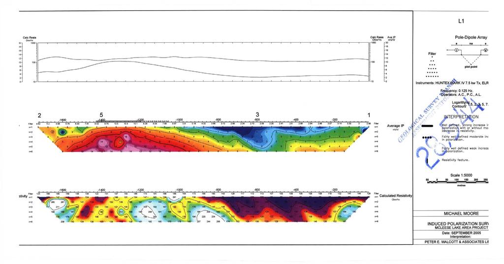
13 INTRODUCTION. Between September 14fh and 17fh, 2005, Peter E. Walcott and Associates Limited undertook induced polarization (I.P.) and magnetic surveying over parts of the Catalan Copper Property, located adjacent to Gibraltar Mine holdings near McLeese Lake, British Columbia, for Michael Moore. The survey was carried out over six randomly oriented lines established by the geophysical crew along or off existing logging roads. Readings of the earth's total magnetic field were recorded using a GSM 19 proton magnetometer on the magnetic survey. Measurements - first to sixth separation - of apparent chargeability - the I.P. response parameter - and resistivity were made along the lines using the pole-dipole technique with a 50 metre dipole. The data are also presented as individual pseudo sections at a scale of 15,000 while the magneti data are presented as coloured postings on a plan map of the lines at 15,000. Peter E. Walcott & Associates Limited Geophysical Services Magnetic & Induced Polarization Surveying Catalan Copper Property
14 4 PROPERTY, LOCATION & ACCESS The property, known as the Catalan Copper Property, is located in the Cariboo Mining District of British Columbia. It is situated some 13 kilometres northeast of the village of McLeese Lake, on Highway 97. Access was obtained by means of two wheel drive vehicle along the many logging roads that connect to the Beaver Valley road. Peter E. Walcott & Associates Limited Geophysical Services Magnetic & Induced Polarization Surveying Catalan Copper Property
15 5 PURPOSE. The purpose of the survey was to determine if there was any I.P. response over the existing geochemical anomalies and old showings in order to see if the method could be used to detect more areas of potential mineralization. Peter E. Walcott & Associates Limited Geophysical Services Magnetic & Induced Polarization Surveying Catalan Copper Property
16 6 SURVEY SPECIFICATIONS. Mametic Survev. The magnetic survey was carried out using a GSM 19 proton precession magnetometer manufactured by GEM Instruments of Richmond Hill, Ontario. This instrument measures variations in the total intensity of the earth s magnetic field to an accuracy of plus or minus one nanotesla. Corrections for daily variations in the earth s field - the diurnal - were made by comparison with a similar instrument set up at a fixed location - the base - where recordings were made at 10 second intervals. The Induced Polarization Survev. The induced polarization (I.P.) survey was conducted using a pulse type system, the principal components of which were manufactured by Huntec Limited of Metropolitan Toronto, Canada and Iris Instruments of Orleans, France. The system consists basically of three units, a receiver (Iris), transmitter (Huntec) and a motor generator (Huntec). The transmitter, which provides a maximum of 7.5 kw d.c. to the ground, obtains its power from a 7.5 kw 400 C.P.S. three phase alternator driven by a Honda 20 h.p. gasoline engine. The cycling rate of the transmitter is 2 seconds currenton and 2 seconds current-off with the pulses reversing continuously in polarity. The data recorded in the field consists of careful measurements of the current (I) in amperes flowing through the current electrodes C1 and Cz, the primary voltages (V) appearing between any two potential electrodes, PI through P7, during the current-on part of the cycle, and the apparent chargeability, (Ma) presented as a direct readout in millivolts per volt using a 200 millisecond delay and a 1000 millisecond sample window by the receiver, a digital receiver controlled by a micro-processor - the sample window is actually the total of ten individual windows of 100 millisecond widths. The apparent resistivity ( fa) in ohm metres is proportional to the ratio of the primary voltage and the measured current, the proportionality factor depending on the geometry of the array used. The chargeability and resistivity are called apparent as they are values which that portion of the earth sampled would have if it were homogeneous. As the earth Peter E. Walcott & Associates Limited Geophysical Services Magnetic & Induced Polarization Surveying Catalan Copper Property
17 7 SURVEY SPECIFICATIONS cont d sampled is usually inhomogeneous the calculated apparent chargeability and resistivity are functions of the actual chargeability and resistivity of the rocks. The survey was carried out using the pole-dipole method of surveying. In this method the current electrode, C1, and the potential electrodes, PI through P7, are moved in unison along the survey lines at a spacing of a (the dipole) apart, while the second current electrode, Cz, is kept constant at infinity. The distance, na between C1 and the nearest potential electrode generally controls the depth to be explored by the particular separation, n, traverse. On this survey a 50 metre dipole was employed and first to fifth separation readings were obtained. In all some 7.2 kilometres of I.P. and magnetic traversing were completed. The survey was carried out along roads and traverses off of these roads, the latter established using the compass and chain technique. Numerous waypoints were recorded using a Garmin XL12 handheld GP unit to facilitate plotting the traverses on a plan map. Data Presentation. The I.P. data are presented as individual pseudo section plots of apparent chargeability and resistivity at a scale of 1:5,000. Plots of the 21 point moving filter - illustrated on the pseudo section - for the above are also displayed in the top window to better show the location of the anomalous zones. The magnetic data is presented as posted values and colour gridded plots along the traverses on a plan map of the same at 1 :5,000. Peter E. Walcott & Associates Limited Geophysical Services Magnetic & Induced Polarization Surveying Catalan Copper Property
18 8 DISCUSSION OF RESULTS The results of the survey suggest the area to exhibit a low chargeability background - 2 to 4 millivolts per volt - above which several anomalous zones are clearly discernible as illustrated on the respective pseudo sections. The strongest of these could be associated with a north-south trending mineralized structure as suggested by the plots of Lines ln, 3E and 400N, and possibly Line 250N. A possible northwest trending feature could be attributable to the chargeability pattern seen on Lines 2E and 350E respectively - note random choice of line numbers. The former anomaly would appear to be associated with the contact of a strong magnetic feature also trending northerly across the survey area as seen by the results on Lines 400N, 1N and 250N respectively, while the latter is generally associated with rocks exhibiting higher magnetic values. Peter E. Walcott & Associates Limited Geophysical Services Magnetic & Induced Polarization Surveying Catalan Copper Property
19 9 SUMMARY, CONCLUSIONS & RECOMMENDATIONS Between September 14fh and 17th, 2005, Peter E. Walcott & Associates Limited undertook limited magnetic and induced polarization surveys for Michael Moore over the property located on the eastern boundary of Gibraltar Mines holdings, near McLeese Lake, British Columbia. The I.P. survey located the presence of a number of zones of anomalous chargeability response on the randomly oriented lines along the existing roads, with the suggestion that they could be representative of two north to northwesterly trending bands of sulphide mineralization. As a result the writer recommends that the plots be compared with the existing ones of soil geochemistry, and if favourable then a grid be established over and beyond the coverage to date for the conduction of geochemical and geophysical surveys prior to investigation of the property by diamond drilling. Respectfully submitted, PETER E. WALCOTT & ASSOCIATES LIMITED Peter E. Walcott, P.Eng. Geophysicist Vancouver, British Columbia July 2006 Peter E. Walcott & Associates Limited Geophysical Services Magnetic & Induced Polarization Surveying Catalan Copper Property
20 10 Peter E. Walcott & Associates Limited Geophysical Services Magnetic & Induced Polarization Surveying Catalan Copper Property
21 11 COST OF SURVEY Peter E. Walcott & Associates Limited undertook the survey on a daily basis. Mobilization and reporting were extra so that the total cost of services provided was $13, Peter E. Walcott & Associates Limited Geophysical Services Magnetic & Induced Polarization Surveying Catalan Copper Property
22 12 PERSONNEL EMPLOYED ON SURVEY. Name Occupation Address Dates Peter E. Walcott Geophysicist Peter E. Walcott &. Oct 21st, 2005 Associates Limited Jul 17th - 19thth W, gth Ave Vancouver, B.C. Andrea Cochrane CC CC Sept. 14th - 17th, 2005 Matt Chomin bc 6< P. Charlie Geophysical Operator Cb S. Cruikshank Geophysical Assistant B. Lajeunesse 66 Cb Cb L. Alexander bc CC bc J. Walcott Report Prep. Peter E. Walcott & Assoc. Limited Jul. 19th, 2006 Peter E. Walcott & Associates Limited Geophysical Services Magnetic & Induced Polarization Surveying Catalan Copper Property
23 13 CERTIFICATION. 1. I am a graduate of the University of Toronto in 1962 with a B.A.Sc. in Engineering Physics, Geophysics Option. 2. I have been practicing my profession for the last forty four years. 3. I am a member of the Association of Professional Engineers of British Columbia and Ontario. 4. I hold no interest, direct nor indirect, in Michael Moore s property, nor do I expect to receive any. Peter E. Walcott, P.Eng. Vancouver, B.C. July 2006 Peter E. Walcott & Associates Limited Geophysical Services Magnetic & Induced Polarization Surveying Catalan Copper Property

24
25
26
27

28
29
30
31
A REPORT. Bear Lake, British Columbia (56' 13'N, ~) N.T.S. 94 D U& Claims surveyed: BL 1, units 2
 N.T.S. 94 D U& Claims surveyed: BL 1, units 2") I PETER E. WALCOTl' Rr ASSOC. LTD. A REPORT AN INDUCED POLARIZATION SURVEY T.?. d." Bear Lake, British Columbia rnk (56' 13'N, 1270 49~) N.T.S. 94 D U& *o Claims surveyed: BL 1, units 2 *a* & 3 BL 2, units
I PETER E. WALCOTl' Rr ASSOC. LTD. A REPORT AN INDUCED POLARIZATION SURVEY T.?. d." Bear Lake, British Columbia rnk (56' 13'N, 1270 49~) N.T.S. 94 D U& *o Claims surveyed: BL 1, units 2 *a* & 3 BL 2, units
CAZADOR RESOURCES LTD.
 1 AN ASSESSMENT REPORT - ON INDUCED POLARIZATION SURVEYING Hit Property Aspen Grove Area, SIMILKAMEEN M.D., B.C. 49" 42" 120" 31'W 92H/lOE. For CAZADOR RESOURCES LTD. KEWWNA, BRITISH COLUMBIA \ BY PETER
PIOTR LUTYNSKI VANCOUVER, BRITISH COLUMBIA
 AN ASSESSMENT REPORT ON GROUND MAGNETIC SURVEYING CHUCHI PROPERTY FORT ST. JAMES AREA, BRITISH COLUMBIA OMINECA M.D. 55 17 N, 124 31 W NTS 93N/ 7&8 Claims Surveyed: 597976, 597878-597880 Survey Dates:
A GEOPHYSICAL REPORT INDUCED POLARIZATION & MAGNETIC SURVEYING
 I A GEOPHYSICAL REPORT INDUCED POLARIZATION & MAGNETIC SURVEYING Bluff Property,,- Cariboo Mining District, B.G4 52"Ol'N, 121" 187W%\% 1,-. N.T.S. 93A004(\? c, ',
--_- A GEOPHYSICAL REPORT AN INDUCED POLARIZATION-SURVEY EQUITY SILVER MINES LIMITED_. John Wesley Ma11 Daniel Morice Merkley Gloria May Merkley
 --_- PETER E. WALCOTI' & ASSOC. LTD. A GEOPHYSICAL REPORT ON AN INDUCED POLARIZATION-SURVEY Houston Area, British Columbia 54O 27'N, 126" 39'W N.T.S. 93L/7E Claims sur-ed: HD 3 & 4 Survey Dates: Sept 16th
GEOPHYSICAL REPORT ON THE PRINCE GEORGE PORPHYRY PROJECT LYNX PROPERTY
 GEOPHYSICAL REPORT ON THE PRINCE GEORGE PORPHYRY PROJECT LYNX PROPERTY Lynx Property Omenica Mining Division British Columbia Tenure # 841107, 742942, 741962 NTS Sheet 093K MTO Event Number - 5434711 UTM
GEOPHYSICAL REPORT CHU CHUA PROJECT Green Mountain Group. KAMLOOPS MINING DIVISION NTS 92P/8E, 82M/5W Lat: 51'24' N Long: 120'00' w
 I GEOPHYSICAL REPORT CHU CHUA PROJECT Green Mountain Group KAMLOOPS MINING DIVISION NTS 92P/8E, 82M/5W Lat: 51'24' N Long: 120'00' w I rvm #.,_..._..._._._.- $...-...! 1 VANCOUVER, B.C. 1 G E 0 I, 0.G
GEOPHYSICAL REPORT ON AN INDUCED POLAR.IZATION SURVEY
 GEOPHYSICAL REPORT ON AN INDUCED POLAR.IZATION SURVEY T & V Claim Groups some 12 miles Northwest of Babine Lake, B.C. Latitude 55' 26'N Longitude 126' 35'W AUTHOR: Glen E. White, Chief Geophysicist,a,
SUMMl'l WlLS LIU. GEOPHYSICAL REPORT. W. CT. a~evenson Y I
 SUMMl'l WlLS LIU. GEOPHYSICAL REPORT W. CT. a~evenson Y3 qi@, 1970. I 2-90 9 CONTENTS - PAGE Introduction... 1 Property... 1 Location and Access... 1 Survey Specifications Survey Grid... 1 Induced Polarization
B.C. Vancouver, Sritish Columbia. Ragas Claims, Omenica M.D., A GEOPHYSICAL REPORT. A GROUKD NAGMETIC 6: ELECTRO?.IAGr\TETIC SURVEY FOR
 A GEOPHYSICAL REPORT A GROUKD NAGMETIC 6: ELECTRO?.IAGr\TETIC SURVEY Ragas Claims, Omenica M.D., B.C. FOR CATRE - 3EK JOINT VENTURE PETER E. WALCOTT & ASSOC. LIPIITED Vancouver, Sritish Columbia OCTOEEEt
PHYSICAL WORK REPORT. the BAY CLAIMS. Omineca Mining Division Smithers, British Columbia N.T.S. 93E 13E/W
 PHYSICAL WORK REPORT the BAY CLAIMS Omineca Mining Division Smithers, British Columbia a N.T.S. 93E 13E/W LATITUDE: 53 57 00 N I LONGITUDE: 127 45 OO W for Home Ventures Ltd. 1201-675 West Hastings Street
Report of Gridding and Magnetic Surveys. On the. Munro Property. Munro and Beatty Townships, Ontario. Larder Lake Mining Division
 Report of Gridding and Magnetic Surveys On the Munro Property Munro and Beatty Townships, Ontario Larder Lake Mining Division Claims: 39 4244 For Big Red Diamond Corporation October 3, 2 Timmins, Ontario
EVENT # AN ASSESSMENT REPORT INDUCED POLARIZATION SURVEYING
 EVENT # 55345 AN ASSESSMENT REPORT ON INDUCED POLARIZATION SURVEYING Fort St. James Area, Omineca M.D., B.C. 54 56 N, 4 ' W NTS: 93N/6 Claims Surveyed: 53537, 5353, 5354, 534 Survey Dates: October st November
GEOLOGICAL MAPPING REPORT ON THE ASH MINERAL CLAIM OSOYOOS MINING DIVISION ASHNOLA RIVER MAP SHEET NTS M092,H019 MCBRIDE CREEK AREA, ASHNOLA RIVER,
 GEOLOGICAL MAPPING REPORT ON THE ASH MINERAL CLAIM OSOYOOS MINING DIVISION ASHNOLA RIVER MAP SHEET NTS M092,H019 LATITUDE 49 o O6, LONGITUDE 120 o 22 MCBRIDE CREEK AREA, ASHNOLA RIVER, KEREMEOS, B.C. CANADA
COMINCO LTD. GEOPHYSICAL REPORT ON AN INDUCED POLARIZATION SURVEY RIM PROPERTY RAFT RIVER AREA KAMLOOPS MINING DIVISION,
 COMNCO LTD. EX PLORAT ON WESTERN DSTRCT NTS: 82M/13E 25 JUNE 1981 GEOPHYSCAL REPORT ON AN NDUCED POLARZATON SURVEY RM PROPERTY RAFT RVER AREA KAMLOOPS MNNG DVSON, B.C. LATTUDE: 51'52'N LONGTUDE : 11 9'45
GEOPHYSICAL REPORT INDUCED POLARIZATION/RESISTMTY SURVEYS. on behalf of TEESHIN REOURCES LTD Argus Road. Oakville, Ontario L6J 354
 GEOPHYSICAL REPORT INDUCED POLARIZATION/RESISTMTY SURVEYS DOME MOUNTAIN PROPERTY, SMITHERS AREA CHRIS, APRIL 1, APRIL 2, APRIL 3, AND MAG 1 CLAIMS CMINECA MINING DMSION, BRITISH COLUMBIA Latitude: 546
r Department of Mines and P,1Pr2!sum Resources I ... ' AS f 5 5 E t.! T R E p (J RT Mt, Sicker, Duncan Area, Vancouver Island, B.C.
 45- I A REPORT - ON AN ELECTROMAGNETIC SURVEY Mt, Sicker, Duncan Area, Vancouver Island, B.C. DUCANEX RESOURCES LIMITED Vancouver, British Columbia r Department of Mines and P,1Pr2!sum Resources I AS f
GEOPHYSICAL REPORT ON THE PRINCE GEORGE PORPHYRY PROJECT HOBBES PROPERTY
 GEOPHYSICAL REPORT ON THE PRINCE GEORGE PORPHYRY PROJECT HOBBES PROPERTY CARIBOO MINING DIVISION, British Columbia NTS: 093J/06, 093J/11 Latitude 54 30 23 N, Longitude 123 7 52 W MTO Event Numbers 4997107;
We are committed to providing accessible customer service. If you need accessible formats or communications supports, please contact us.
 We are committed to providing accessible customer service. If you need accessible formats or communications supports, please contact us. Nous tenons à améliorer l accessibilité des services à la clientèle.
Trout Lake Area, British Columbia (500, 50' N., 117O 40' t?) Claims surveyed: WE, VIK. Survey Dates: June 6th - " 12th, 84 FOR
 Claims surveyed: WE, VIK. Survey Dates: June 6th - 12th, 84 FOR") PETER E. WALCOTT Rr ASSOC. LTD. P ~ L C ~ \%%95 GEOLOGICAL BRANCH ASSb:fiSMENT REPOPT A GEOPlIYSICAL REPORT Trout Lake Area, British Columbia (500, 50' N., 117O 40' t?) Claims surveyed: WE, VIK Survey
PETER E. WALCOTT Rr ASSOC. LTD. P ~ L C ~ \%%95 GEOLOGICAL BRANCH ASSb:fiSMENT REPOPT A GEOPlIYSICAL REPORT Trout Lake Area, British Columbia (500, 50' N., 117O 40' t?) Claims surveyed: WE, VIK Survey
We are committed to providing accessible customer service. If you need accessible formats or communications supports, please contact us.
 We are committed to providing accessible customer service. If you need accessible formats or communications supports, please contact us. Nous tenons à améliorer l accessibilité des services à la clientèle.
'?a October 31, 1990 COMINCO LTD. EXPLORATION NTS: 93 G-6. Cariboo Mining Division. Latitude: 53 deg. 16' N Longitude: 123 deg.
 COMINCO LTD. EXPLORATION NTS: 93 G-6 WESTERN DISTR CT Cariboo Mining Division Latitude: 53 deg. 16' N Longitude: 123 deg. 13' W Work Dates: June 7-8, 1990 '?a October 31, 1990 D.J. Holcombe ....... A ASSESSMENT
PHOENIX GEOPHYSICS LIMITED REPORT ON THE VLF-EM AND TOTAL FIELD MAGNETOMETER SURVEYS ON THE
 PHOENIX GEOPHYSICS LIMITED REPORT ON THE VLF-EM AND TOTAL FIELD MAGNETOMETER SURVEYS ON THE TAN CLAIMS, CHILLIWACK AREA NEW WESTMINSTER MINING DIVISION, BRITISH COLUMBIA FOR LORNEX MINING CORPORATION LIMITED
GEOLOGICAL BRANCH ASSESSMENT REB(3,R.T
 GEOPHYSICAL REPORT on the PHANTOM CLAIMS 2-3 CARIB00 MINING DIVISION N.T.S. 93B/16 East by H. Limion, Chief Geophysicist J. A. Turner, Geologist January 1983 CLAIMS OWNED BY: WORK DONE BY: Newmont Exploration
PERCY CONTRACTING SERVICES LTD.
 GEOLOGICAL REPORT ON TEN PLACER LEASES (3139, 3140, 3141, 3142, 3143, 3144, 3145, 3146, 3147, 3148) MOREHEAD CREEK CARIB00 MINING DIVISION, B.C. 938/12W (52 38 N, 121 47 W) For PERCY CONTRACTING SERVICES
ASSESSMENT REPORT I.P./RESISTIVITY AND MAGNETICS SURVEY ON THE HAUTETE PROPERTY LATITUDE: 55O 12' N LONGITUDE: 126O 07' W
 NTS: 93W1 ASSESSMENT REPORT I.P./RESISTIVITY AND MAGNETICS SURVEY ON THE HAUTETE PROPERTY LATITUDE: 55O 12' N LONGITUDE: 126O 07' W OMINECA MINING DISTRICI'. B.C. CLAIMS COVERED : TET 1-8 TIME PERIOD:
Airborne Geophysical TOTAL COST: $8, ,
 Ministry of Energy, Mines & Petroleum Resources Mining & Minerals Division BC Geological Survey Assessment Report Title Page and Summary TYPE OF REPORT [type of survey(s)]: Airborne Geophysical TOTAL COST:
COMINCO LTD. HORIZONTAL LOOP EM AND MAGNETIC SURVEYS ON SHA. CLAIMS 1, 2, 7 and 8 NELSON AND FORT STEELE MINING DIVISIONS, B.C.
 COMINCO LTD. EXPLORATION WESTERN DISTRICT NTS: 82-F/1 HORIZONTAL LOOP EM AND MAGNETIC SURVEYS ON SHA CLAIMS 1, 2, 7 and 8 - ASSESSMENT REPORT - NELSON AND FORT STEELE MINING DIVISIONS, B.C. Latitude Longitude
BALTO RESOURCES LTD. (Owner & Operator) GEOPHYSICAL ASSESSMENT REPORT. (Event Number ) on the SED MINERAL CLAIM.
 GEOPHYSICAL ASSESSMENT REPORT. (Event Number ) on the SED MINERAL CLAIM.") BALTO RESOURCES LTD. (Owner & Operator) GEOPHYSICAL ASSESSMENT REPORT (Event Number 5173274) on the SED MINERAL CLAIM (Tenure 392163) Kamloops Mining Division NTS 092I.047 Centre of Work 5589550N, 667600E
BALTO RESOURCES LTD. (Owner & Operator) GEOPHYSICAL ASSESSMENT REPORT (Event Number 5173274) on the SED MINERAL CLAIM (Tenure 392163) Kamloops Mining Division NTS 092I.047 Centre of Work 5589550N, 667600E
1 CLAIMS GEOPHYSICAL REPORT ON BOYAL SITUATE NORTHEAST OF TILLICUM MOUNTAIN GOLD AREA BURTON - NAKUSP SIQCAEJ MINING DIVISION
 GEOPHYSICAL REPORT ON BOYAL 1 CLAIMS SITUATE NORTHEAST OF TILLICUM MOUNTAIN GOLD AREA BURTON - NAKUSP SIQCAEJ MINING DIVISION CONSULTING GEOLOGIST AUGUST 1983 VANCOUVER B *C INDEX INTRODUCTION ooa,.eoaaa.aaaoaaooaoa~ao~o
for the Greenwood Mining Division, B.C. NTS 82E/7W Latitude 49' 27' W, Longitude 118' 5 Prepared by a= D. Dylan Watt, B.Sc.
 t. b LOGnO: 37~ -08 m. ACTIO#: for the AMP AMP 2 AMP 3 t AMP 4 CLAIMS Greenwood Mining Division, B.C. NTS 82E/7W Latitude 49' 27' W, Longitude 8' 5 %E c,w zc *& a w Prepared by a= -4c. D. Dylan Watt, B.Sc.
2013 GEOLOGICAL ASSESSMENT REPORT SHERIDAN HILL PROPERTY
 2013 GEOLOGICAL ASSESSMENT REPORT ON THE SHERIDAN HILL PROPERTY NEW WESTMINSTER MINING DIVISION BRITISH COLUMBIA NTS 092G07 49 16 31 NORTH LATITUDE, 122 39 48 WEST LONGITUDE PREPARED FOR Sheridan Hill
t+o...&zz!. ASSESSMENT REPORT Department of Miner and Petroleum Resources MAP.,- INDUCED POLAKIZATION SURVEY OVER THE BROOKS PROSPECT
 5873 INDUCED POLAKIZATION SURVEY OVER THE BROOKS PROSPECT BROOKS PENINSULA AREA VANCOUVER ISLAND, B.C. NANAIMO AND ALBERNI MINING DIVISIONS BY Z. B. DOBORZYNSKI JANUARY, 1976 Department of Miner and Petroleum
LIST OF FIGURES APPENDICES
 RESISTIVITY / INDUCED POLARIZATION SURVEY EL PORVENIR PROJECT MUNICIPALITY OF REMEDIOS, ANTIOQUIA, COLOMBIA LOGISTICS REPORT M-17427 APRIL 2017 TABLE OF CONTENTS Abstract... 1 1. The Mandate... 2 2. El
PROSPECTORS ASSISTANCE PROGRAM MINISTRY OF ENERGY AND MINES
 BRITISH COLUMBIA PROSPECTORS ASSISTANCE PROGRAM MINISTRY OF ENERGY AND MINES GEOLOGICAL SURVEY BRANCH PROGRAM YEAR: 1999/2000 REPORT #: PAP 99-l 6 NAME: KIM ANSCHETZ PROSPECTORS TlEPORT on the 99 LOUIS
Report of Induced Polarization Surveys and. Total Field Magnetic Surveys. Turtle Pond, Emmons Lake, Prig, North Glatz, Glatz, and Double E Grids
 Report of nduced Polarization Surveys and Total Field Magnetic Surveys On the Turtlepond Project Turtle Pond, Emmons Lake, Prig, North Glatz, Glatz, and Double E Grids Turtlepond Lake Area, Ontario Claim
490 20' 30" North Latitude ' 30" West Longitude
 _._.. I CONSULTING GEOLOGISTS 605-602 WEST HASTINGS STREET, VANCOUVER, B.C. V6B 1P2 TELEPHONE: (604) 689-5533 6 I F: ASSESSMENT REPORT ON THE PATSY 1 MINERAL CLAIM ' '?%2% I WHISTLE CREEK, HEDLEY ARE L-l-
CONSULTING GEOLOGICAL 8: MINING ENGINEERS STINGS STREET DA V6E 2E9 GEOPHYSICAL SURVEY SILVER QUEEN 2 ZEBALLOS AREA. B.C.
 DOLMAGE CAMPBELL & ASSOCIATES (1 975) LTD. CONSULTING GEOLOGICAL 8: MINING ENGINEERS STINGS STREET DA V6E 2E9 '' 1E O L 0 G I C A.L B'x;&a:f2:#& 'SESSMENT REPObT 12, Assessment RESOURCES LTD. 111 ReDort
The survey covered claims, in part or in full, DUCKLING 3, 4, 5, 4 fraction, and 5 fraction.
 514 687-6671 XXX- 602 West Hastin~a StroeP, Vata;sn@ouver, BritlsA fhlum~b~a, Garaadsa B81apphgtaa DISCUSS ION OF MAGNETOMETER SURVEY ON DUCKLING CLAIMS FOR DONNA MINES LTD. (N0P.L.) Submitted to: DONNA
compietea since tnat date, and wnicn comprisea btage I ot tne recommended
 compietea since tnat date, and wnicn comprisea btage I ot tne recommended four-stage program. GEOLOGY & MINERALIZATION The property situate6 on the southeast slope of Nickel Plate Mtn., and within the
REPORT ON MAGNETOMETER SURVEY TIK-1 CLAIM e&f KAMLOOPS MINING DTVISION. by D. Hendry D. C. MILLER. February 3, for
 REPORT ON MAGNETOMETER SURVEY TIK-1 CLAIM 92-1-14 e&f KAMLOOPS MINING DTVISION lat. 50 57 ' 12" long. 121O23 ' 37" OWNER: ST. JOSEPH EXPLORATIONS LIMITED OPERATIOR: ST. JOSEPH EXPLORATIONS LIMITED by D.
UNION MINIERE EXPLORATIONS AND MINING CORPORATION LIMITED ASSESSMENT REPORT ON FITINAT MINERAL CLAIM. Alberni Mining Division Record No.
 M F )( UNION MINIERE EXPLORATIONS AND MINING CORPORATION LIMITED Suite 200, 4299 Canada Way, Burnaby, B.C. V5G 1 H4 Telephone (604) 437-9491 ASSESSMENT REPORT ON GEOCHEMICAL SOIL SURVEYS AND ROCKSAMPLING
..!I AXE CLAIMS ON THE. for RICHCORE EXPLORATIONS LTO. GREENWOOD MINING DIVISION BRITISH COLUMBIA. Latitude 49O 30"; Longitude 118' 30'W NTS 82E/9W
 ON THE AXE CLAIMS for RICHCORE EXPLORATIONS LTO. GREENWOOD MINING DIVISION BRITISH COLUMBIA Latitude 49O 30"; Longitude 118' 30'W NTS 82E/9W... -... ~ i.,...._.'..!i Vancouver, B.C. September, 1980 P.
Fox 2-Record No. 2524
 F HELICOPTER E.M. AND MAGNETOMETER SURVEY OVER THE FOX CLAIMS, OMINECA MINING DISTRICT BRITISH COLUMBIA ON BEHALF OF OWNER MR. MIKE BOYLE Claims: Fox l-record No. 2523 Fox 2-Record No. 2524 Location 126'
GEOPHYSICAL REPORT. Airborne Magnetometer Survey. of the SHEEP-GOAT GROUP OF MINERAL CLAIMS. near Li l looet, B.C.
 GEOPHYSICAL REPORT 977 Airborne Magnetometer Survey of the SHEEP-GOAT GROUP OF MINERAL CLAIMS near Li l looet, B.C. Lillooet Mining Division (Lat.51 'lot Long. 122 40' 7 5t0[2L05E. for DUFFEY LAKES MINES
, ,
 Ministry of Energy, Mines & Petroleum Resources Mining & Minerals Division BC Geological Survey Assessment Report Title Page and Summary TYPE OF REPORT [type of survey(s)]: Airborne Magnetic Survey TOTAL
ASSESSMENT REPORT ON THE PEAVINE PROJECT. DGW & Associates # Alberni Street, Vancouver, British Columbia, V6E 4V2
 ASSESSMENT REPORT ON THE PEAVINE PROJECT KAMLOOPS MINING DIVISION BRITISH COLUMBIA NTS 082M 12 Latitude 51 36' 19.0"North -- Longitude --119 47' 27.0"West UTM Zone 11, NAD 83 5720827N 306744E Prepared
ASSESSMENT REPORT ON THE VLF-EM SURVEY. Trail Creek Mining Division NTS: 82 F/4 W Longitude: 1 17' 49' 50" Latitude: 49O 03' 40"
 ASSESSMENT REPORT ON THE JERO 5 MINERAL CLAIM ROSSLAND, BRJTISH COLUMBIA VLF-EM SURVEY Trail Creek Mining Division NTS: 82 F/4 W Longitude: 1 17' 49' 50" Latitude: 49O 03' 40" Owner: Operator: Author:
Reconnaissance. Of the. Denis mineral claims. Situated at Kilometer 844 of the Alaska Highway. Liard Mining Division. Northeastern British Columbia
 Reconnaissance Of the Denis mineral claims Situated at Kilometer 844 of the Alaska Highway Liard Mining Division Northeastern British Columbia N.T.S. 94M.075 Latitude 59 42 25 Longitude 127 13 12 Field
BALFOUR MINING LTD. (N.P.L.) HAM GROUP 92-P-6, CLINTON M. D.8 B. C. Lat 51 17'N, GEOCHEMICAL REPORT. V. CUKOR, P. Eng.
 HAM GROUP 92-P-6, CLINTON M. D.8 B. C. Lat 51 17'N, GEOCHEMICAL REPORT. V. CUKOR, P. Eng.") 34q '7 BALFOUR MINING LTD. (N.P.L.) HAM GROUP 92-P-6, CLINTON M. D.8 B. C. Lat 51 17'N, Long 12lo14'W GEOCHEMICAL REPORT, V. CUKOR, P. Eng. January 31, 1972 TABLE OF CONTENTS 1. INTRODUCTION 2. PROPERTY,
34q '7 BALFOUR MINING LTD. (N.P.L.) HAM GROUP 92-P-6, CLINTON M. D.8 B. C. Lat 51 17'N, Long 12lo14'W GEOCHEMICAL REPORT, V. CUKOR, P. Eng. January 31, 1972 TABLE OF CONTENTS 1. INTRODUCTION 2. PROPERTY,
7 MILES WEST OF PORT HARDY, B.C.
 GEOPHYSICAL REPORT VERTICAL INTENSITY MAGNETOMEER SURVEY ON LUK CLAIMS, 7 MILES WEST OF PORT HARDY, B.C. 50' 127O SE BY R. E. SHIELDS UNDER SUPERVISION OF J. R. BILLINGSLEY FOR SECOND0 MINING LTD. (N.
RECONNAISSANCE GEOCHEMICAL SURVEY
 RECONNAISSANCE GEOCHEMICAL SURVEY LEGAL, RITA, LOUISE FR. (CHAPLEAU GROUP) REVERTED CROWN GRANTS CHAPLEAU CREEK AREAJ, SLOC& MINING DIVISION 82 F/11W Lat: 49'44" Long: 117"22'W MINERAL RESOURCES BRANCH
DRILLING REPORT ON THE HIGHLAND VALLEY, KAMLOOPS MINING DIVISION, OWNED BY GAZA MINES LTD., NEW JERICHO DEVELOPMENT AND TECK CORPORATION
 DRILLING REPORT ON THE GAZA 1 AND JERICHO 1 AND 2 MINERAL CLAIMS / (RECORD NUMBERS 159, 492 AND 161) HIGHLAND VALLEY, KAMLOOPS MINING DIVISION, LATITUDE 50' 26' N; LONGITUDE 120' 55' W; NTS 92-I/7W OWNED
a 93 J GEOLOGICAL BRANCH ON THE COMINCO LTD. EXPLORATION WESTERN DISTRICT ASSESSMENT REPORT GEOPHYSICAL SURVEYS WEE 4,5,8,12 MINERAL CLAIMS
 COMNCO LTD. EXPLORATON a 93 J 10111 WESTERN DSTRCT ASSESSMENT REPORT ON GEOPHYSCAL SURVEYS ON THE WEE 4,5,8,12 MNERAL CLAMS Record No's 9568, 9569, 10219, 10512 Cariboo Mining Division Latitude: 54 den.
for the Greenwood Mining Division, B.C. NTS 82E/7W 29' W, Longitude 118' 53' N Prepared by D. Dylan Watt, B.Sc.
 for the FltE NO: u VOLT 1, VOLT 2, VOLT 3, & VOLT 4 CLAIMS Greenwood Mining Division, B.C. NTS 82E/7W Latitude 49' 29' W, Longitude 118' 53' N Prepared by D. Dylan Watt, B.Sc. #309-1996 Trutch Street Vancouver,
OWNER OPERATOR: BLACKWATER EXPLORATIONS LTD. REPORT ON RESISTIVITY PROFILING SURVEY PLACER GOLD EXPLORATION
 OWNER OPERATOR: BLACKWATER EXPLORATIONS LTD. REPORT ON RESISTIVITY PROFILING SURVEY PLACER GOLD EXPLORATION CARIBOO MINING DISTRICT NTS 93G CLAIM PC682023 Latitude 53 13 35.64 Longitude 122 49 40.65 by
We are committed to providing accessible customer service. If you need accessible formats or communications supports, please contact us.
 We are committed to providing accessible customer service. If you need accessible formats or communications supports, please contact us. Nous tenons à améliorer l accessibilité des services à la clientèle.
DEVELOPMENT REPORT. Lone I Mineral Claim Group. Wild Horse River Area Cranbrook, B.C.
 DEVELOPMENT REPORT Lone I Mineral Claim Group Wild Horse River Area Cranbrook, B.C. Fort Steele Mining District NTS 82G/12E 49 38 35 Latitude 115 38 00 Longitude LONE PEAK PLACER LTD. 514-13th Avenue South
UTM (NAD 83, ZONE 10) rq df;- LLOYD GEOPHYSICS INC. VANCOUVER, BRITISH COLUMBIA APRIL, 2004
 rq df;- LLOYD GEOPHYSICS INC. VANCOUVER, BRITISH COLUMBIA APRIL, 2004") 1 A GEOPHYSICAL REPORT ON AN INDUCED POLARIZATION SURVEY ON THE RAD PROPERTY, CLINTON MINING DIVISION, TATLA LAKE, BRITISH COLUMBIA. UTM (NAD 83, ZONE 10) - $ 3 5730000 m NORTH \:. 427500 rq df;- c3-+;,l
1 A GEOPHYSICAL REPORT ON AN INDUCED POLARIZATION SURVEY ON THE RAD PROPERTY, CLINTON MINING DIVISION, TATLA LAKE, BRITISH COLUMBIA. UTM (NAD 83, ZONE 10) - $ 3 5730000 m NORTH \:. 427500 rq df;- c3-+;,l
NTS 93L/9W GEOCHEMICAL AND GEOPHYSICAL REPORT MONA CLAIM OMINICA MINING DIVISION. Lati tude 54036'N; Longitude 'W
 GEOCHEMICAL AND GEOPHYSICAL REPORT ON MONA CLAIM OMINICA MINING DIVISION Lati tude 54036'N; Longitude 126018'W NTS 93L/9W April 1981 Paul Plicka Consulting Geologist LOCATION MAP INTRODUCTION TABLE OF
, , ,
 Ministry of Energy and Mines BC Geological Survey Assessment Report Title Page and Summary TYPE OF REPORT [type of survey(s)]: Airborne Geophysic TOTAL COST: 9,4. AUTHOR(S): Walcott, A. Walcott, P SIGNATURE(S):
ASSESSMENT REPORT MAGNETOMETER SURVEY GOLDEN ROD, GOLDEN ROD #2. Long.: General Delivery, Vananda, B. C.
 ASSESSMENT REPORT MAGNETOMETER SURVEY GOLDEN ROD, GOLDEN ROD #2 t=/ NTS 92~110w Lat.: Long.: 49O 44' N 124O 34' W Owner: E. Johanson General Delivery, Vananda, B. C. Operator: Rhyolite Resources I nc.
GEOCSZNICAL - SURVEY. ICAMLOOPS Kl.D. 2'' 6;kr. HY "'f. Alfred R. Allen,P.Eng. 1 NO.%=...,... 6"- 'I.
 t i.i GEOCSZNICAL - SURVEY i p' ICAMLOOPS Kl.D. 2'' 6;kr HY 50-64 +."'f 121-51 NE 5-10-70 : 19-10-70 Alfred R. Allen,P.Eng. I) ' 1 6"- 'I. 1 NO.%=...,..... Q.C. EXPLORATIONS LTD. 2Cl- 535 Kowe Street Vancouver
PHYSICAL WORK REPORT ON THE. KINGDOMlwINERAL LILLOOET MINING DIVISION. NTS Map Sheet 92J/15W. Co-Ordinates North: East
 PHYSICAL WORK REPORT ON THE KINGDOMlwINERAL CLAIM LILLOOET MINING DIVISION NTS Map Sheet 92J/15W Co-Ordinates North: 50 48 East 120 48 For Assessment Work BY Edward Skoda October 15,2002 Vancouver, British
LLOYD MINERALS INC. VANCOUVER, BRITISH COLUMBIA
 EVENT # 836 AN ASSESSMENT REPORT ON HELIBORNE MAGNETIC SURVEYING BIG ONION PROPERTY SMITHERS AREA, BRITISH COLUMBIA OMINECA M.D. 4 48.8 N, 6 3.76 W NTS 94L/W Claims: 374,37,376,6867,76,88893,63,64467,64468
CONTENTS 1. INTRODUCTION. 2. THE D.C. RESISTIVITY METHOD 2.1 Equipment 2.2 Survey Procedure 2.3 Data Reduction
 (i) CONTENTS 1. INTRODUCTION page 1 2. THE D.C. RESISTIVITY METHOD 2.1 Equipment 2.2 Survey Procedure 2.3 Data Reduction 3 3 3 3 3. GEOPHYSICAL RESULTS 3.1 General 3.2 Discussion 4 4 4 4. LIMITATIONS 5
GEOLOGICAL BRANCH ASSESSMENT REPORT 12. FItE NO: ACTION: THE GOLDEN MINING DIVISION, GOLDEN, Including THE NTS MAP; M82K/15W
 ACTION: FItE NO: Including 1990 GEO-CHEM SURVEY RESULTS -- THE AVD CLAIMS - THE GOLDEN MINING DIVISION, GOLDEN, B.C. NTS MAP; M82K/15W Lat. 50 deg. 55 Min. Long 116 deg. 55 min. For GEOLOGICAL BRANCH ASSESSMENT
PRECIOUS METALS. owner. JMT Services Corp. GEOCHPlICAL SAMPLING CHELASLIE WCE, NORTH CENTRAL, B.C. OMINECA MINING DIVISION NTS 93F/5E & 6W
 PRECIOUS METALS REPORT ON 1980 RECONNAISSANCE GEOCHPlICAL SAMPLING CHELASLIE WCE, NORTH CENTRAL, B.C. OMINECA MINING DIVISION NTS 93F/5E & 6W LATITUDE 53O28 N LONGITUDE 125O31 W DATES Qp WORK: JULY 10
32?un North of Hope, B.C.,
 Geological Reconnaissance Assessment Report on portions of the Gilt Creek Group (Mike, C.G., Julie, and Gilt Mineral Claims) Situated 32?un North of Hope, B.C., New Westminster Mining Division N 'P 97H/11W
Spectrometer Survey Over the Creelman-Roberts Property Roberts and Creelman Townships, Ontario
 PO Box 19 1479 Government Road Larder Lake, Ontario PK 1L, Canada Phone (7) 4-11 Fax (7) 4-191 Spectrometer Survey Over the Creelman-Roberts Property Roberts and Creelman Townships, Ontario Spectrometer
GEOPHYSICAL REPORT THE CAVZ CLAIMS
 GEOPHYSICAL REPORT Magnetometer Survey on THE CAVZ CLAIMS CAVZ M.C.'s 1 to 12, 15 to 26, 29 to 40, 45 to 54 Trail Peak, Omineca M.D. 13 miles northeast of Fort Babine 550 ) 126 S.E. by G.Podolsky J.Russell
PROSPECTING Survey Over the AULD PROPERTY Auld Township, Ontario
 PO Box 219, 14579 Government Road, Larder Lake, Ontario, P0K 1L0, Canada Phone (705) 643-2345 Fax (705) 643-2191 www.cxsltd.com PROSPECTING Survey Over the AULD PROPERTY C Jason Ploeger, B.Sc, P.Geo August
'-7' REPORT ON A MAGNETOMETER SURVEY OVER PART OF THE MAX CLAIM GROUP 1-20 LAC LE JEUNE AREA KAMLOOPS MINING DIVISION KAMLOOPS, BRITISH COLUMBIA
 I,., - SUITE 102. 222 BELLEVUE WES t ANCOUVER, B. '-7' REPORT ON A I MAGNETOMETER SURVEY OVER PART OF THE MAX CLAIM GROUP 1-20 LAC LE JEUNE AREA KAMLOOPS MINING DIVISION KAMLOOPS, BRITISH COLUMBIA 50-30
SUPPLEMENT TO MAGNETOMETER 6 ELECTROMAGNETIC SURVEY REPORT. DATED NOVEMBER l, 1973 CIGLEN INVESTMENTS LIMITED CLAIMS GROUP BAD VERMILLION LAKE AREA
 ^ A R l ^ 1974 010 PROJECTS UNIT SUPPLEMENT TO MAGNETOMETER 6 ELECTROMAGNETIC SURVEY REPORT DATED NOVEMBER l, 1973 CIGLEN INVESTMENTS LIMITED CLAIMS GROUP BAD VERMILLION LAKE AREA DISTRICT OF RAINY RIVER
SELF POTENTIAL SURVEY OVER THE JAY GROUP, INVERMERE AREA GOLDEN MINING DIVISION, BFUTISH COLUMBIA NTS 82W8W7 82W9W LATLONG 50 30' ' FOR
 - GEOLOGICAL SURVEY BRANCH ASSESSMENT REPORTS -- -- DATE RECEI?/::D 06T 10 1996 - SELF POTENTIAL SURVEY OVER THE JAY GROUP, INVERMERE AREA GOLDEN MINING DIVISION, BFUTISH COLUMBIA NTS 82W8W7 82W9W LATLONG
BALTO RESOURCES LTD. (Owner & Operator) GEOPHYSICAL ASSESSMENT REPORT. (Event Number ) on the SED MINERAL CLAIM.
 GEOPHYSICAL ASSESSMENT REPORT. (Event Number ) on the SED MINERAL CLAIM.") BALTO RESOURCES LTD. (Owner & Operator) GEOPHYSICAL ASSESSMENT REPORT (Event Number 4829051) on the SED MINERAL CLAIM (Tenure 392163) Kamloops Mining Division NTS 092I.047 Centre of Work 5590150N, 678800E
BALTO RESOURCES LTD. (Owner & Operator) GEOPHYSICAL ASSESSMENT REPORT (Event Number 4829051) on the SED MINERAL CLAIM (Tenure 392163) Kamloops Mining Division NTS 092I.047 Centre of Work 5590150N, 678800E
TIGER GOLD EXPLORATION CORPORATION. Prospecting Over the HARKER HERITAGE PROPERTY AREA 10. Harker Township, Ontario
 PO Box 219, 14579 Government Road, Larder Lake, Ontario, P0K 1L0, Canada Phone (705) 643-2345 Fax (705) 643-2191 www.cxsltd.com TIGER GOLD EXPLORATION CORPORATION Prospecting Over the HARKER HERITAGE PROPERTY
Lat. 52' 43' N Long ' W
 &A exploration ltd MINING ENGINEERING GEOLOGY- GEOPHYSICS 4570 HOSKINS ROAD, NORTH VANCOUVER, 6. C. TELEPHONE (804) 985,7921 V7K 2R1 GEOLOGICAL AND GEOCHEMICAL REPORT on the BLUE CLAIMS Cariboo Mining
Gold Mountain Group Gold Mtn. A, B, C & D Mineral Claims Record Nos. 697, 698, 699 & 700. Island Mountain Cariboo Mining Division British Columbia
 GOLD POINT RESOURCES LTD. Geophysical Survey Gold Mountain Group Gold Mtn. A, B, C & D Mineral Claims Record Nos. 697, 698, 699 & 700 Island Mountain Cariboo Mining Division British Columbia Vancouver,
N. Lat. 50' 34' W. Long. 120' 33'
 ASSESSMENT REPORT ON THE HANK I MINERAL CLAIM RECORD NO. 2831 (7) CHERRY CREEK AREA KAMLOOPS MINING DIVISION KAMLOOPS, BRITISH COLUMBIA N. Lat. 50' 34' W. Long. 120' 33' 92 - I - 10E for ANGLO WESTERN
Gold c 8 Rl!TI I8 8 I0 n0 '8 Off VANCOUVER, B.C. btandard I Property
 ,- PROSPECTING REPORT For the 1 Gold c 8 Rl!TI I8 8 I0 n0 '8 Off ig@ VANCOUVER, B.C. btandard I Property I SALMON GOVERNMENT AGENT ARM I Tenure Number 554772 Revelstoke Mining Division, B.C. BCGS GRID
AN INDUCED~ POLARIZATION SURVEY. HIGHLAND VALLEY, BRITISH CoLUMBIA. (50, lil, SE) for JERICHO MINES LIMITED HUNTING SURVEY CORPORATION LIMITED
 for JERICHO MINES LIMITED HUNTING SURVEY CORPORATION LIMITED") AN INDUCED~ POLARIZATION SURVEY JERICHO PROPERTY HIGHLAND VALLEY, BRITISH CoLUMBIA (50, lil, SE) for. JERICHO MINES LIMITED HUNTING SURVEY CORPORATION LIMITED Toronto, Ontario December, 1962 u TABLE OF
AN INDUCED~ POLARIZATION SURVEY JERICHO PROPERTY HIGHLAND VALLEY, BRITISH CoLUMBIA (50, lil, SE) for. JERICHO MINES LIMITED HUNTING SURVEY CORPORATION LIMITED Toronto, Ontario December, 1962 u TABLE OF
GRAVITY AND MAGNETIC SURVEY NECHAKO BASIN STUDY ACQUISITION AND PROCESSING PHASE
 GRAVITY AND MAGNETIC SURVEY NECHAKO BASIN STUDY ACQUISITION AND PROCESSING PHASE Report prepared for the B.C. Ministry of Energy and Mines Resource Development Division New Ventures Branch by Bemex Consulting
REPORT. on the. Omineca Mining Division, British Columbia. Latitude N., Longitude W. NTS map sheet 93F/7E. James W. McLeod, P.Geo.
 REPORT on the CHU MOLYBDENUM PROPERTY Omineca Mining Division, British Columbia Latitude 53 21 N., Longitude 124 37 W. NTS map sheet 93F/7E James W. McLeod, P.Geo. on behalf of Mr. Chris Delorme TABLE
On An. DATE OF REPORT: January 7, 1976 GEOPHYSICAL R3PORT. On Behalf Of
 57 GEOPHYSICAL R3PORT On An INDUCED POLABI ZATION SURVEY On Behalf Of BOW RIVXi RESOURCES LTDe Pat mineral claims, Rossland area, Trail Creek Mining Diviaion B, C. Lat. 49 O 0 O150"1 Long. 11'(&52'~ N.T.S.
CONTENTS. Location, Access and History...6. Tenure Status and Geology Regional Andy Property Geology Map...9
 TYPE OFWORK IN THIS REPORT EXTENT OF WORK (rn METRTC UNITS) ON WHICH CLAIMS PROJECT COSTS APPORTIONED (incl. support) GEOLOGICAL (scale, area) Ground, mapping Photo interpretation GEOPHYSICAL (line-kilometres)
PROSPECTING REPORT THE WALLACE CLAIM OMENICA MINING DIVISION. 54" x6" 3.d d. for. Reako Exlorat ions Ltd. Wallace Rev. C.G.
 PROSPECTING REPORT ON THE WALLACE CLAIM OMENICA MINING DIVISION 54"44 14 1x6" 3.d d by David A. Howard P.Eng. for Reako Exlorat ions Ltd. Claim Locat ion Wallace Rev. C.G. #1560 Dome Mountain Area 9 3
Prospecting Report 'S Office i DB Property, B.C. -J Negro Creek Nelson Mining District NTS 82F.050. Operator: Kootenay Gold Inc.
 . '.' I"' i9 12 Prospecting Report 'S Office i DB Property, B.C. -J Negro Creek Nelson Mining District NTS 82F.050 Operator: Kootenay Gold Inc. Owner: Darlene Lavoie Work Performed Summer of 2007 Report
September 23rd-26th, 2016,May 18th, 2017 YEAR OF WORK: 16/ , , ,
 Ministry of Energy and Mines BC Geological Survey Assessment Report Title Page and Summary TYPE OF REPORT [type of survey(s)]: induced polarization/airborne magnetic TOTAL COST: 23,4 AUTHOR(S): Walcott,
_.----." 2) Gravimetric Profiles... In Pocket TABLE OF CONTENTS PAGE - SUMMARY AN0 CONCLUSIONS... 1A GRAVIMETRIC SURVEY Field Procedures...
 Gravimetric Profiles... In Pocket TABLE OF CONTENTS PAGE - SUMMARY AN0 CONCLUSIONS... 1A GRAVIMETRIC SURVEY Field Procedures...") _.----." TABLE OF CONTENTS PAGE - SUMMARY AN0 CONCLUSIONS... 1A GRAVIMETRIC SURVEY... 1 Field Procedures... 1 Elevation and Horizontal Control... 2 Meter Procedures... 2 Computing Procedures... 2 Plotting...
_.----." TABLE OF CONTENTS PAGE - SUMMARY AN0 CONCLUSIONS... 1A GRAVIMETRIC SURVEY... 1 Field Procedures... 1 Elevation and Horizontal Control... 2 Meter Procedures... 2 Computing Procedures... 2 Plotting...
' +ER? lg05. ACJISff: FILE NO: MUNRO LAKE AREA OYOOS MINING DIVISION NTS 82E/12, 13W ALMADEN RESOURCES CORPORATION GRANT A. HENDRICKSON, P,GEO.
 ACJISff: ' +ER? lg05 u a _r FILE NO: MUNRO LAKE AREA OYOOS MINING DIVISION NTS 82E/12, 13W FOR ALMADEN RESOURCES CORPORATION BY e JANUARY 29, 1995. GRANT A. HENDRICKSON, P,GEO. TABLE OF CONTENTS -- Introduction.........
GEOLOGICAL BRANCH ASSESSMENT REPORT
 GEOLOGICAL BRANCH ASSESSMENT REPORT REPORT ON GEOPHYSICAL GROUND SURVEYS ON THE CHILI CLAIM MAGNETIC, VLF DIP ANGLE ELECTROMAGNETIC, AND VLF RESISTIVITY SURVEYS BY HI LIMION SEPTEMBER 12, 1986 &! FILMED
GEOCHEMICAL REPORT ON A SOIL SAMPLING SURVEY OF PORTIONS OF THE KR GROUP OF MINERAL CLAIMS OF PLATEAU METALS LIMITED.
 GEOCHEMICAL REPORT ON A SOIL SAMPLING SURVEY OF PORTIONS OF THE KR GROUP OF MINERAL CLAIMS OF PLATEAU METALS LIMITED By Kol Lovang Christopher Riley, P. Eng., Supervisor c Vancouver, B. c. Work Performed:
J.D. Mason, Prof. Engineer. Report on the Reconnaissance Magnetometer Survey. Completed for. North American Platinum Corporation Ltd.
 Report on the Reconnaissance Magnetometer Survey Completed for North American Platinum Corporation Ltd. Olivine Mountain Property, Tulameen, B.C. J.D. Mason, Prof. Engineer. November 28, 1967. Certificate
We are committed to providing accessible customer service. If you need accessible formats or communications supports, please contact us.
 We are committed to providing accessible customer service. If you need accessible formats or communications supports, please contact us. Nous tenons à améliorer l accessibilité des services à la clientèle.
CJP EXPLORATION INC.
 PO Box 219 14579 Government Road Larder Lake, Ontario P0K 1L0, Canada Phone (705) 643-1122 Fax (705) 643-2191 CJP EXPLORATION INC. Spectrometer Survey Over the SHEBA PROPERTY Nouvel Township, Ontario TABLE
4. Geological maps published by the Ontario Department of Mines.
 52J08NWei45 S2J08NWa6B1 SMYE 010 AMALGAMATED RARE EARTH MINES LTD. *, SAVANT LAKE PROSPECT x ONTARIO INTRODUCTION t This Is a report on a group of 28 claims control led by Amalgamated Rare Earth Mines
Date Submitted: June General Nature of Report: Examination of Placer Samples
 General Nature of Report: Examination of Placer Samples Claim: Gold Channel, Record Number 3775!8 1 (Gold Channel Placer Property) Mining Division: Cariboo NTS 093 G 09 W and E Latitude 520 23 N' Longitude1210
Report. On a 3D Magnetic Inversion. For. Cadillac Ventures Ltd. And. Newcastle Minerals Ltd. Pickle Lake Project. Ontario, Canada
 Report On a 3D Magnetic Inversion For Cadillac Ventures Ltd And Newcastle Minerals Ltd. Pickle Lake Project Ontario, Canada SCOTT HOGG & ASSOCIATES LTD October 2010 TABLE OF CONTENTS 1 INTRODUCTION...
ASSESSMENT REPORT TITLE PAGE AND SUMMARY
 ASSESSMENT REPORT TITLE PAGE AND SUMMARY TITLE OF REPORT: 2016 Prospecting Report Sphynx Claim TOTAL COST: $167.56 AUTHOR(S): Giacomo Grassi SIGNATURE(S): NOTICE OF WORK PERMIT NUMBER(S)/DATE(S): STATEMENT