REPORT ON GEOPHYSICAL SURVEYS ON THE BAMAJI LAKE PROPERTY CROBIE PROJECT, NW ONTARIO OF UMEX INC.
|
|
|
- Marjory Clarke
- 5 years ago
- Views:
Transcription
1
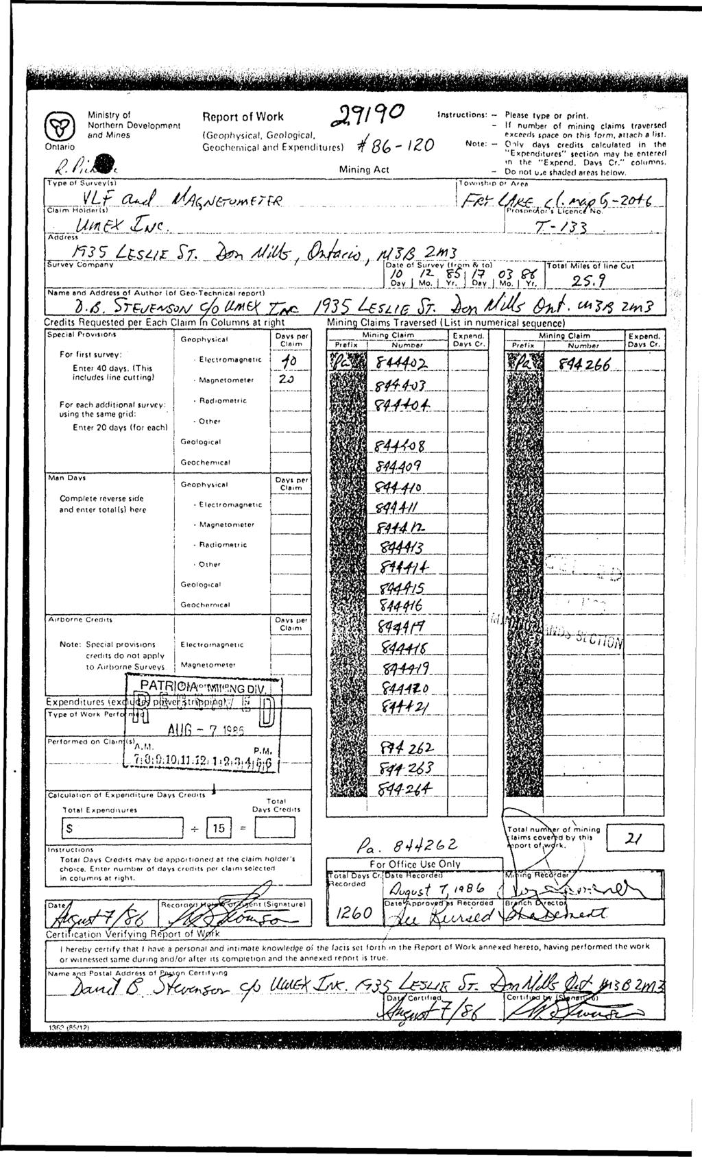
2 S20e3NWe«28 S20«3NWee37 FRY LAKE REPORT ON GEOPHYSICAL SURVEYS ON THE BAMAJI LAKE PROPERTY CROBIE PROJECT, NW ONTARIO OF UMEX INC. Patricia Mining Division NTS 52 0/3 Latitude 51 10'N Longitude 91 24'W JUN 1 'A WB6 mm UHDS SfflW Roger J Caven, BASc.P Eng., Consulting Geophysicist 28 Balaby Crescent, Don Mills, Ontario, CANADA M3C 2B7 Telephone: (416)
3 52O«3NW0e N*e«37 FRY LAKE 010C TABLE OF CONTENTS Page 1. INTRODUCTION 2. PROPERTY LOCATION AND ACCESS 3. PHYSIOGRAPHY 4. PREVIOUS WORK 5. GEOPHYSICAL SURVEYS 6. INTERPRETATION?. DISCUSSION OF RESULTS Figure 1 Location Map Figure 2 Map of claim? Magnetic Survey Map, Dvg no t EM-16 VLF-EM Survey, Dvg no 2 EM-16 Profiles, Dvg no 3 Interpretation map, Dvg no 4 After text After text In pocket In pocket In pocket In pocket
4 1. INTRODUCTION -2- During the time period December 85-Merch 36, ground geophysical work was carried out for Umex inc. by J Hodge and Associates on mineral claims In the Bamaji Lake area of NW Ontario. The claims are underlain by Archaean mafic and felsic metavolcanics, metasediments and felsic intrusives. 2. PROPERTY LOCATION AND ACCESS The Bamaji Lake property is located approximately 90 km southwest of Pickle Lake on the north side of Bamaji Lake and south of Moosetegon and Fry Lakes. The location is shown in Fig 1. The geographic coordinates are: latitude 51 10' N, and longitude 91 24' W, within N.T.S. Map 52 0/3. Access to the claims is obtained by air from Pickle Lake. The claims are shown in Fig 2. The property worked upon consists of 30 contiguous mining claims in Patricia Mining Division with the following numbers: P , , , and , all inclusive. Claim map: Fry Lake, G PHYSIOGRAPHY The Bamaji Lake area is of relatively low relief at about 400 rn above sea level. Overburden cover is extensive, although some outcrops are found, particularly on the shores of the many lakes. 4. PREVIOUS WORK The area of the present claims h33 been explored previously by Cochenour Willans Gold Mines Ltd in 1973 or earlier. The geology has been mapped by the Ontario Geological Survey and the results published in 1979: Wallace, Henry, 1979: Slate Falls Area Eastern Part, District of Kenora (Patricia Portion), OGS Prelim. Map P2248, Geological Series, Scale 1:15840 or 1 inch to 1/4 mile. Geology 1977,1978. Aeromagnetic coverage over the area v/83 obtained May - November 1959, by Spartan Air Services Ltd, and publihed as Geophysics Paper 902, Blackstone Lake, Ontario, NTS 52 0/3. 5. GEOPHYSICAL SURVEYS From December 1985 to March 1986 the previously cut grid was surveyed by total field magnetometer and VLF-EM in two stages. The instruments used were a Geometrics G A proton magnetometer with a sensitivity of 1 nanotesla (nt), and a Geonics EM-16 VLF-EM instrument which reads the tilt-engle and quadrature of the low frequency plane radio waves transmitted by the Naval Submarine Communications stations. The transmitter station used for the present survey was the NLK, Seattle, Washington, operating with a carrier frequency of 24.8 khz. The survey wss conducted on lines with a 100 m spacing, and a 25 m station interval along the line. The magnetic survey also used intermediate stations where the operator deemed necessary to obtain sufficient information. A few intermediate stations were also read with the EM-16. The magnetic data are presented on a contour map with corrected magnetometer readings from which a base value of 60,000 nt has been subtracted (Dwg no 1). The contours are shown with full total field value. The VLF-EM data are shown as a contour plot of the filtered inphase readings (Dwg no 2), and abo a3 stacked profiles of inphase and quadrature readings (Dwg no 3). The geophysical interpretation is presented on Dwg no 4.
5 -3-6. INTERPRETATION The aeromagnetic map shows a slight magnetic high over the northern part of the survey grid and extending W5W, with the peak just west of the present work, probably caused by the rock3 which are anomalous in U, Th, Au, and Ag. The area and these anomalies(?) were investigated by McCombe Mining & Exploration Ltd (1954), Kirkland Townsite Gold Mines Ltd (1968), and Urange3ellschaft Canada Ltd and possibly others. The aeromagnetic high has a limited strike length to the east 8nd is interpreted to be caused by a series of localized magnetic anomalies approximately along regional strike from the above anomalous mineral occurrences. Partially coincident with the magnetic anomalies are medium strength YLF-EM conductors some of which are near interpreted felsic intrusives and also near a fault zone shown on the geological map, but not unambiguously interpreted from the magnetics. The YLF-EM data have been filtered by the Fraser method for the inphase (tilt angle) readings, and the positive values contoured to show the anomalies. The EM-16 data has been collected with a station interval of 25 m, which for near surface phenomena tends to give slightly lower peak anomalies than the shorter spacings. The VLF-EM conductors are therefore medium strength to weak with a few exceptions being somewhat stronger. From a geophysical view the best VLF-EM conductors are those associated with the magnetic anomalies in the north part of the grid, within the interpreted mafic volcanics, and those in the SE corner of the grid along the inferred sediment / felsic intrusive contact on the geology map. The Bamaji Lske fault 13 represented by weak to very weak Y'LF- EM conductor? without any significant magnetic signatures. A geophysical interpretation map over the Bamaji Lake grid has been arrived at by combining the information present in both the magnetic and VLF-EM maps and comparing vith the mapped geology Interpretation of some lithologic units has been attempted using magnetic activity as the indicator Some deviation from the published geology was found, 3 result not unexpected with the widespread overburden cover. Further refinement should be possible with more ground truth. The magnetic data are influenced not only by the rocktypes but also by the faulting and alteration. The combined data has made it possible to arrive at a structural map showing the Bamaji Lake fault and a wt or parallel faults striking NE, The geology map 3hows these faults as terminating at the Bamaji Lake fault, but the magnetic survey indicates that they possibly continue to the SW into the felsic intrusives. A third set of faults strike just ea^t of north and also appear to transect the Bamaji Lake fault. No definite distinction can be seen in the magnetics between the felsic volcanics and the sediments shown on the geology map. Since the contact is presumed to be under Bamaji Lake and the interpretation has been made from very few outcrops of sediments, there may well remain many uncertainties?. DISCUSSION OF RESULTS The magnetic survey has provided data for an interpretation of 3ome of the major rock units in the grid area, and in combination with the VLF-EM map has made it possible to attempt an interpretation of structures. The EM data h8ve many anomalous responses which can be separated into essentially three sets of conductor strings. The northernmost string of conductors appears to be along strike vith metalliferous occurrences previously investigated further we3t. The Bamaji Lake fault forrn3 a second string of VLF-EM conductors, all weak to very weak and devoid of magnetic correlation. Further south a third string of anomalies are the potentially most conductive and have a weak magnetic association. They fall along the inferred sediment/fei sic intrusive contact. Further follow- 'jp vith electromagnetic methods such as horizontal loop with MaxMin II would be limitedjk<r^ e^ ^ the "conductors" only, induced polarization may be possible on the northern conductors/^ r April 23, 1986 / ' i- /V "- - r Roger J Caven, P Eni r~ Con3ulting Geophysicist?, \
6
7
8
9
10
11
12
13
14
15
16
17
18
19
20
21
22
23
24
We are committed to providing accessible customer service. If you need accessible formats or communications supports, please contact us.
 We are committed to providing accessible customer service. If you need accessible formats or communications supports, please contact us. Nous tenons à améliorer l accessibilité des services à la clientèle.
Total Magnetic Field and VLF Surveys on the Swayze Property. Claim Swayze Township. Porcupine Mining Division
 1 January, 016 NTS: 041 O 15 Total Magnetic Field and VLF Surveys on the Swayze Property Claim 475471 Swayze Township Porcupine Mining Division 380850E, 599450N UTM Z17N NAD83 Report Prepared for: 540
SUPPLEMENT TO MAGNETOMETER 6 ELECTROMAGNETIC SURVEY REPORT. DATED NOVEMBER l, 1973 CIGLEN INVESTMENTS LIMITED CLAIMS GROUP BAD VERMILLION LAKE AREA
 ^ A R l ^ 1974 010 PROJECTS UNIT SUPPLEMENT TO MAGNETOMETER 6 ELECTROMAGNETIC SURVEY REPORT DATED NOVEMBER l, 1973 CIGLEN INVESTMENTS LIMITED CLAIMS GROUP BAD VERMILLION LAKE AREA DISTRICT OF RAINY RIVER
Fox 2-Record No. 2524
 F HELICOPTER E.M. AND MAGNETOMETER SURVEY OVER THE FOX CLAIMS, OMINECA MINING DISTRICT BRITISH COLUMBIA ON BEHALF OF OWNER MR. MIKE BOYLE Claims: Fox l-record No. 2523 Fox 2-Record No. 2524 Location 126'
PHOENIX GEOPHYSICS LIMITED REPORT ON THE VLF-EM AND TOTAL FIELD MAGNETOMETER SURVEYS ON THE
 PHOENIX GEOPHYSICS LIMITED REPORT ON THE VLF-EM AND TOTAL FIELD MAGNETOMETER SURVEYS ON THE TAN CLAIMS, CHILLIWACK AREA NEW WESTMINSTER MINING DIVISION, BRITISH COLUMBIA FOR LORNEX MINING CORPORATION LIMITED
GEOLOGICAL BRANCH ASSESSMENT REPORT
 GEOLOGICAL BRANCH ASSESSMENT REPORT REPORT ON GEOPHYSICAL GROUND SURVEYS ON THE CHILI CLAIM MAGNETIC, VLF DIP ANGLE ELECTROMAGNETIC, AND VLF RESISTIVITY SURVEYS BY HI LIMION SEPTEMBER 12, 1986 &! FILMED
ASSESSMENT REPORT ON THE VLF-EM SURVEY. Trail Creek Mining Division NTS: 82 F/4 W Longitude: 1 17' 49' 50" Latitude: 49O 03' 40"
 ASSESSMENT REPORT ON THE JERO 5 MINERAL CLAIM ROSSLAND, BRJTISH COLUMBIA VLF-EM SURVEY Trail Creek Mining Division NTS: 82 F/4 W Longitude: 1 17' 49' 50" Latitude: 49O 03' 40" Owner: Operator: Author:
41P11SE2001 OP93-39S ASQUITH
 41P11SE2001 OP93-39S ASQUITH 010 REPORT ON THE PROSPECTING, GEOPHYSICAL AND GEOLOGICAL SURVEYING PROGRAM BY HARRY FERDERBER ON THE PROPERTY OF TRINITY EXPLORATIONS ASQUITH TOWNSHIP, LARDER LAKE MINING
We are committed to providing accessible customer service. If you need accessible formats or communications supports, please contact us.
 We are committed to providing accessible customer service. If you need accessible formats or communications supports, please contact us. Nous tenons à améliorer l accessibilité des services à la clientèle.
Introducti on. Land Survey. Geomagnetic Survey. Geomagnetic Results and Interpretati ons - Conclusions and Recommendations C
 m M 42A86SW8281 63.42 PRICE 010 C O H T E H l 42A86SW828I 63.42 PRICE 010C Introducti on Land Survey Geomagnetic Survey Geomagnetic Results and Interpretati ons - Conclusions and Recommendations - - -
1 i I.; :<7 6EOLOGICAL BRANCH ASSESSMENT REPORT HLEM, VLF-EM AND MAGNETOMETER TEST SURVEY ON THE ARC PROPERTY FOR SURVEY BY SJ GEOPHYSICS LTD.
 f - ~ --- j LOG NO: MAR 2 a 1992,,, -- - - - -- L$TiC'P;: I.; 1 i HLEM, VLF-EM AND MAGNETOMETER TEST SURVEY ON THE ARC PROPERTY FOR SURVEY BY SJ GEOPHYSICS LTD. SLOCAN M.D., B.C. N.T.S. 88 F/10 d 2- :
Geomagnetic. Guibord Township Group #2, Bast Part Hollineer Consolidated Gold Mints. Ltd
 42Aa9SEe267 63.19,9 GUIBORD """"" 11 Geomagnetic Guibord Township Group #2, Bast Part Hollineer Consolidated Gold Mints. Ltd 010 Introduction During the period March 31 t 1965 to Jan. 10, 1966 a magnetometer
ASSESSMENT REPORT N 0. REPORT ON HORIZONTAL COPLANAR LOOP ELECTROMAGNETIC SURVEY HOUSTON AREA OF BRITISH COLUMBIA AQUITAINE COMPANY OF CANADA DURING
 tf 62 33 REPORT ON HORIZONTAL COPLANAR LOOP ELECTROMAGNETIC SURVEY IN THE HOUSTON AREA OF BRITISH COLUMBIA BY AQUITAINE COMPANY OF CANADA c DURING MARCH 21 - MARCH 25, 1977 MINERAL RESOURCES BRANCH ASSESSMENT
Report of Gridding and Magnetic Surveys. On the. Munro Property. Munro and Beatty Townships, Ontario. Larder Lake Mining Division
 Report of Gridding and Magnetic Surveys On the Munro Property Munro and Beatty Townships, Ontario Larder Lake Mining Division Claims: 39 4244 For Big Red Diamond Corporation October 3, 2 Timmins, Ontario
RECEIVED. tn r-"t."' Magnetometer and VLF-EM Surveys Assessment Report. South Cobalt Silver Project South Lorrain Twp. Mhakari Gold Corp.
 RECEVED APR 1 5 111 OOSC!C! AESSMET tn r-"t. Magnetometer and VLF-EM Surveys Assessment Report South Cobalt Silver Project South Lorrain Twp. Mhakari Gold Corp. March 211 TS 31 M/3-4 Meegwich Consultants
Report of Induced Polarization Surveys and. Total Field Magnetic Surveys. Turtle Pond, Emmons Lake, Prig, North Glatz, Glatz, and Double E Grids
 Report of nduced Polarization Surveys and Total Field Magnetic Surveys On the Turtlepond Project Turtle Pond, Emmons Lake, Prig, North Glatz, Glatz, and Double E Grids Turtlepond Lake Area, Ontario Claim
GEOLOGICAL, GEOCHEMICAL, GEOPHYSICAL, & PHYSICAL ASSESSMENT REPORT ON THE MISTY -NIE-SAM PROPERTY ATLIN MINING DIVISION N.T.S.
 GEOLOGCAL, GEOCHEMCAL, GEOPHYSCAL, & PHYSCAL ASSESSMENT REPORT ON THE MSTY -NE-SAM PROPERTY Claims: MSTY (20883) MSTY 2 (20884) NE (20903) NE 2 (20904) POLE (20 885) SAM (20844) SAM 2 (20845) ATLN MNNG
AND HORSEFLY PROSPECTS, N.W. BRITISH COLUMBIA NTS, 103H/ll, 14 FOR ATNA RESOURCES LTD DELTA GEOSCIENCE LTD
 AND HORSEFLY PROSPECTS, N.W. BRITISH COLUMBIA NTS, 103H/ll, 14 FOR ATNA RESOURCES LTD BY DELTA GEOSCIENCE LTD FE T A. HENDRICKSON, P.GEO. 1 . TABLE OF CONTENTS Introduction............. Page 1. Personnel..........
SELCO EXPLORATION COMPANY LIMITED
 --..-..-...-.....l.iibibiiiiiiiiiiiiiii II III S2J16NW9001 52J16NW0014A1 PASHKOKOGAM LAKE 0 10 SELCO EXPLORATION COMPANY LIMITED GEOPHYSICAL REPORT CLAIMS 200696 TO 200707 PATRICIA MINING DIVISION August
We are committed to providing accessible customer service. If you need accessible formats or communications supports, please contact us.
 We are committed to providing accessible customer service. If you need accessible formats or communications supports, please contact us. Nous tenons à améliorer l accessibilité des services à la clientèle.
MAGNETIC SURVEY REPORT. on the O'BRIEN CLAIM GROUP. Deloro Township Porcupine Mining Division, Ontario. for PAMOUR PORCUPINE MINES LIMITED
 42A06NE0456 2.7439 DELORO 010 MAGNETIC SURVEY REPORT on the O'BRIEN CLAIM GROUP Deloro Township Porcupine Mining Division, Ontario as se C/J 1* m O for PAMOUR PORCUPINE MINES LIMITED by Kian A. Jensen,
FILE NO. ASSESSMENT REPORT VLF-EM GEOPHY S I CS BUCK CLAIMS. Moyie River and Perry Creek Area FORT STEELE MINING DIVISION. NTS 82 F/8 E and 82 G/5 W
 FILE NO. ASSESSMENT REPORT on - VLF-EM GEOPHY S I CS BUCK CLAIMS Moyie River and Perry Creek Area FORT STEELE MINING DIVISION NTS 82 F/8 E and 82 G/5 W Latitude 49 27' N Longitude 116 03' W PETER KLEWCHUK
Magnetic Field and VLF Surveys on the Shining Tree Property. Claims: , , , , , , , ,
 December 29, 2014 NTS: 041P11 Magnetic Field and VLF Surveys on the Shining Tree Property Claims: 1203361, 4251801, 4251803, 4251805, 4263067, 4263068, 4270940, 4270436, 4276740 Churchill and Asquith Townships
for the Greenwood Mining Division, B.C. NTS 82E/7W 29' W, Longitude 118' 53' N Prepared by D. Dylan Watt, B.Sc.
 for the FltE NO: u VOLT 1, VOLT 2, VOLT 3, & VOLT 4 CLAIMS Greenwood Mining Division, B.C. NTS 82E/7W Latitude 49' 29' W, Longitude 118' 53' N Prepared by D. Dylan Watt, B.Sc. #309-1996 Trutch Street Vancouver,
2014 AEROQUEST AIRBORNE HELI-BORNE VTEM PLUS AND HORIZONTAL MAGNETIC GRADIOMETER SURVEY ASSESSMENT REPORT CAMERON GOLD PROJECT
 2014 AEROQUEST AIRBORNE HELI-BORNE VTEM PLUS AND HORIZONTAL MAGNETIC GRADIOMETER SURVEY ASSESSMENT REPORT CAMERON GOLD PROJECT PREPARED BY: Nick Walker. January 2015 SUMMARY This report presents the results
Assessment Report by the Canadian Nickel Co. Ltd. Magnetometer Survey. Larder Lake Mining Division Lebel Tovnship, Ontario
 32084Nwea67 2.331* LEBEL 010 Assessment Report by the Canadian Nickel Co. Ltd. Magnetometer Survey Larder Lake Mining Division Lebel Tovnship, Ontario Claims L-531657 L-531658 L-531111 Map No.: M-359,
OEOMAQNETIC SURVEI QUIBORD TOWNSHIP GROUP #2 HOLLINGER CONSOLIDATED GOLD MINES, LTD.
 OEOMAQNETIC SURVEI QUIBORD TOWNSHIP GROUP #2 HOLLINGER CONSOLIDATED GOLD MINES, LTD. 42Ae9SE0268 63.1502 GUIBORD (711(71 Introduction During the period January 5 - February 26, 1965, a magnetometer survey
I PRELIMINARY MAGNETOMETER SURVEY
 .REPORT O N I PRELIMINARY MAGNETOMETER SURVEY and GEOLOGICAL RECONNAISSANCE L AND K GROUP OF CLAIMS Located 8 Miles East of Princeton, B. C. Similkameen Mining Division Lat. 49' 27' N. Long. 120' 16' W
REPORT ON GEOPHYSICAL SURVEYS. ASTA AND RITA CLAIMS Nanaimo Mining District NTS 92L1 Latitude 58' 08'N Longitude 126O 12'W for FALCONBRIDGE LTD.
 REPORT ON GEOPHYSICAL SURVEYS ASTA AND RITA CLAIMS Nanaimo Mining District NTS 92L1 Latitude 58' 08'N Longitude 126O 12'W for FALCONBRIDGE LTD. Vancouver, B. C. November, 1 984 J. L. Lebel, P. Eng. MPH
ASSESSMENT' REPORT GEOPHYSICAL REPORT ON THE ATTORNEY 2 CLAIM (4 UNITS) OMINECA MINING DIVISION SHEILA A. CRAWFORD.
 OMINECA MINING DIVISION SHEILA A. CRAWFORD.") ASSESSMENT' REPORT GEOPHYSICAL REPORT ON THE ATTORNEY 2 CLAIM (4 UNITS) OMINECA MINING DIVISION by SHEILA A. CRAWFORD LOCATION: 57z17' N Latitude 127 11' W Longitude N.T.S. 94E/6E OWNER/OPERATOR: SEREM
ASSESSMENT' REPORT GEOPHYSICAL REPORT ON THE ATTORNEY 2 CLAIM (4 UNITS) OMINECA MINING DIVISION by SHEILA A. CRAWFORD LOCATION: 57z17' N Latitude 127 11' W Longitude N.T.S. 94E/6E OWNER/OPERATOR: SEREM
Toronto, Ontario November 16, This report may not be reproduced, in whole or in part, without the written permission of Derry, Michener S Booth.
 13 2.1354 L ITTLE 010 GEOPHYSICAL SURVEYS, LITTLE TOWNSHIP CLAIM GROUP OB-F TIMMINS AREA PORCUPINE MINING DIVISION, ONTARIO Toronto, Ontario November 16, 1973 This report may not be reproduced, in whole
I 4.w.g //old. Lat. 5Oo35T Long T. for. By: James R. Glass, P. Eng. June 6, DUSTY MAC MINES LTD. (N.P.L.)
") 440 6 REPORT ON MAGNETOMETER SURVEY POD GROU'OF CLAIMS HIGHLAND VALLEY KAMLOOPS MINING DIVISION Lat. 5Oo35T Long. 120 55T 9.2 1 //old for DUSTY MAC MINES LTD. (N.P.L.) By: James R. Glass, P. Eng. June
440 6 REPORT ON MAGNETOMETER SURVEY POD GROU'OF CLAIMS HIGHLAND VALLEY KAMLOOPS MINING DIVISION Lat. 5Oo35T Long. 120 55T 9.2 1 //old for DUSTY MAC MINES LTD. (N.P.L.) By: James R. Glass, P. Eng. June
SANDER GEOPHYSICS LW 42D13SW ISLE ST. IGNACE RICHMONl
 SANDER GEOPHYSICS LW 42D13SW8363 83.1-117 ISLE ST. IGNACE 010 1305 RICHMONl REPORT ON THE HELICOPTER BORNE EM AND MAGNETOMETER SURVEY OFF ST. IGNACE ISLAND, LAKE SUPERIOR THUNDERBAY MINING DISTRICT, ONTARIO
NICOLA M.D King Street West, April, 1969 AMALG 1-44 MINERAL CLAIMS 1. OWNER: Dr. F. R. Burton, W. M. Sirola, P. Eng.
 REPORT ON ' MAGNETIC AND ELECTROMAGNETIC SURVEY AMALG 1-44 MINERAL CLAIMS 1. NICOLA M.D. 49'501 N - 12Oo57f W OWNER: Dr. F. R. Burton, 1506-44 King Street West, Toronto 1, Ontario. by W. M. Sirola, P.
magnetic and electromagnetic survey carried out to locate on the ground an aeromagnetic zone and associated In-put anomalies indi
 42IICWMW 63.2293 FLINCH LAKE O1O 6 3- Z* The President and Directors, Consolidated Manitoba Mines Limited. 114 East 90th Street. New York City 10028. New York. U. S. A. Gentlemen: This report describes
COMINCO LTD. HORIZONTAL LOOP EM AND MAGNETIC SURVEYS ON SHA. CLAIMS 1, 2, 7 and 8 NELSON AND FORT STEELE MINING DIVISIONS, B.C.
 COMINCO LTD. EXPLORATION WESTERN DISTRICT NTS: 82-F/1 HORIZONTAL LOOP EM AND MAGNETIC SURVEYS ON SHA CLAIMS 1, 2, 7 and 8 - ASSESSMENT REPORT - NELSON AND FORT STEELE MINING DIVISIONS, B.C. Latitude Longitude
The survey covered claims, in part or in full, DUCKLING 3, 4, 5, 4 fraction, and 5 fraction.
 514 687-6671 XXX- 602 West Hastin~a StroeP, Vata;sn@ouver, BritlsA fhlum~b~a, Garaadsa B81apphgtaa DISCUSS ION OF MAGNETOMETER SURVEY ON DUCKLING CLAIMS FOR DONNA MINES LTD. (N0P.L.) Submitted to: DONNA
42H88SW NEWMAN
 42H88SW0003 63.8199 NEWMAN 010 TRIPOINT MINES LIMITED, Suite 305-100 Adelaide St. West, Toronto l, Ontario. Gentlemen: Your Company recently conducted a combined magneticelectromagnetic survey over a ten
Report on The Magnetic Survey. Property of Loydex Resources Inc. Keigat Lake Area. Red Lake Mining Division
 010 Report on The Magnetic Survey On The Property of Loydex Resources Inc. SANDY POINT PROJECT Keigat Lake Area District of Kenora, Patricia Portion Red Lake Mining Division N.T.S. 52-N-8 Whitby, Ontario
GROUND GEOPHYSICAL SURVEYS Magnetometer and Horizontal Loop EM. KoKoKo Project Ferrim Lake and Tasse Lake Grids. PANTHEON VENTURES LTD.
 NTS 31 M/4 GROUND GEOPHYSCAL SURVEYS Magnetometer and Horizontal Loop EM KoKoKo Project Ferrim Lake and Tasse Lake Grids PANTHEON VENTURES LTD. September 2007,..-- :. 57 RECEVED JAN 16 ~'2:n GEOSCENCf
r.- L A c, i*-...-' &V set T.ANTHONY GROUP k COUTURE LAKE GROUP* STURGEON LAKE AREA ONTARIO COPCONDA-YORK RESOURCES INC. GEOPHYSICAL SURVEYS ON THE
 52J02SE8687 63.4234 SQUAW LAKE 010 r.- b; i*-...-' &V COPCONDA-YORK RESOURCES INC. GEOPHYSICAL SURVEYS ON THE T.ANTHONY GROUP k COUTURE LAKE GROUP* STURGEON LAKE AREA ONTARIO December 30, 1983. L A c,
GEOPHYSICAL REPORT ON A VLF-EM SURVEY OVER THE BOSS 1 AND 2 CLAIMS HEDLEY AREA SIMILKAMEEN MINING DIVISION BRITISH COLUMBIA
 GEOPHYSICAL REPORT i ON A VLF-EM SURVEY OVER THE BOSS 1 AND 2 CLAIMS HEDLEY AREA SIMILKAMEEN MINING DIVISION BRITISH COLUMBIA PROPERTY SURVEYED BY : 11.0 h S60W of Bedley : 49' 120O SE : N.T.S. 92~18~
Assessment Work Report. on the Geophysical Surveys carried out over the
 Assessment Work Report on the Geophysical Surveys carried out over the PINE GROUP of Mineral Claims 951-J-15-W Lillooet Mining Division Goldbridge, B.C. Long 122 48' Lat. 50 48' by Levon Resources Ltd.
Gold Mountain Group Gold Mtn. A, B, C & D Mineral Claims Record Nos. 697, 698, 699 & 700. Island Mountain Cariboo Mining Division British Columbia
 GOLD POINT RESOURCES LTD. Geophysical Survey Gold Mountain Group Gold Mtn. A, B, C & D Mineral Claims Record Nos. 697, 698, 699 & 700 Island Mountain Cariboo Mining Division British Columbia Vancouver,
Detour West Gold Project Technical Overview. April, 2018
 Detour West Gold Project Technical Overview April, 2018 Detour West Project Overview Detour West is a 7,680 hectare property located at the northwest margin of the Abitibi Greenstone Belt, 20 km west of
ROYAL OAK RESOURCES LIMITED. Report on Claims No. TB and TB Fulford Township Thunder Bay Mining Division Ontario
 42E15SEW16 2.10781 ALFRED LAKE 010 ROYAL OAK RESOURCES LIMITED Report on Claims No. TB 941301 and TB 941302 Fulford Township Thunder Bay Mining Division Ontario By RECEIVED JAN 06 Greenstone Resource Management
UNION MINIERE EXPLORATIONS AND MINING CORPORATION LIMITED ASSESSMENT REPORT ON FITINAT MINERAL CLAIM. Alberni Mining Division Record No.
 M F )( UNION MINIERE EXPLORATIONS AND MINING CORPORATION LIMITED Suite 200, 4299 Canada Way, Burnaby, B.C. V5G 1 H4 Telephone (604) 437-9491 ASSESSMENT REPORT ON GEOCHEMICAL SOIL SURVEYS AND ROCKSAMPLING
GEOPHYSICAL DATA SET (GDS) 1084B METADATA
 1084B METADATA") GEOPHYSICAL DATA SET (GDS) 1084B METADATA GENERAL INFORMATION Official Name of the Data Set or Information Holding: Ontario Airborne Geophysical Surveys, Magnetic Gradiometer and Gamma-Ray Spectrometric
GEOPHYSICAL DATA SET (GDS) 1084B METADATA GENERAL INFORMATION Official Name of the Data Set or Information Holding: Ontario Airborne Geophysical Surveys, Magnetic Gradiometer and Gamma-Ray Spectrometric
Two Gold Properties for Option, Northwestern Ontario
 1 Two Gold Properties for Option, Northwestern Ontario My two grassroots gold exploration properties located about 60-70 km southwest of Pickle Lake, northwestern Ontario. The properties are located near
for the Greenwood Mining Division, B.C. NTS 82E/7W Latitude 49' 27' W, Longitude 118' 5 Prepared by a= D. Dylan Watt, B.Sc.
 t. b LOGnO: 37~ -08 m. ACTIO#: for the AMP AMP 2 AMP 3 t AMP 4 CLAIMS Greenwood Mining Division, B.C. NTS 82E/7W Latitude 49' 27' W, Longitude 8' 5 %E c,w zc *& a w Prepared by a= -4c. D. Dylan Watt, B.Sc.
COPPER REEF Mining Corporation. July 18, 2018
 COPPER REEF Mining Corporation Analyses of Airborne South and West of Alberts Lake Anomalies July 18, 2018 R.W. Groom, PhD,BMath Petros Eikon Incorporated Orangeville, ON Stephen Masson, M.Sc., P.Geo.
GEOPHYSICAL REPORT ON AN INDUCED POLAR.IZATION SURVEY
 GEOPHYSICAL REPORT ON AN INDUCED POLAR.IZATION SURVEY T & V Claim Groups some 12 miles Northwest of Babine Lake, B.C. Latitude 55' 26'N Longitude 126' 35'W AUTHOR: Glen E. White, Chief Geophysicist,a,
McVicar Lake Gold Property Lang Lake Greenstone Belt Ontario. Argo Gold Inc. (ARQ)
") McVicar Lake Gold Property Lang Lake Greenstone Belt Ontario Argo Gold Inc. (ARQ) Forward Looking Statements This presentation may contain forward-looking statements that involve a number of risks and
McVicar Lake Gold Property Lang Lake Greenstone Belt Ontario Argo Gold Inc. (ARQ) Forward Looking Statements This presentation may contain forward-looking statements that involve a number of risks and
7 MILES WEST OF PORT HARDY, B.C.
 GEOPHYSICAL REPORT VERTICAL INTENSITY MAGNETOMEER SURVEY ON LUK CLAIMS, 7 MILES WEST OF PORT HARDY, B.C. 50' 127O SE BY R. E. SHIELDS UNDER SUPERVISION OF J. R. BILLINGSLEY FOR SECOND0 MINING LTD. (N.
sq N & %%.& GEOPHYSICAL CONSULTING rr SERVICES LTD. $%& Long. 118o3OtW N.T.S. 82 E/15 -I- AUTROR: Glen E. Whi*e, B.Sc., P. %g.
 -\ GEOCHEMICAL EXPORT.,~.,~..'.. AMORE MINERALS 1NCORPOR;ITZC,' ~. 3rd fl5 Geo 3. and 2 mineral claims, Vernon- ~ $lining Division, B. C. Lat. 49 47'T?,,/ Long. 118o3OtW N.T.S. 82 E/15 -I- AUTROR: Glen
Spring 2018 Drill Program
 VANCOUVER, BC / April 5, 2018 / Margaret Lake Diamonds Inc. (TSX-V: DIA; FSE: M85) ("Margaret Lake" or the "Company") is pleased to report preparations are now underway to commence a diamond drill program
NTS 93L/9W GEOCHEMICAL AND GEOPHYSICAL REPORT MONA CLAIM OMINICA MINING DIVISION. Lati tude 54036'N; Longitude 'W
 GEOCHEMICAL AND GEOPHYSICAL REPORT ON MONA CLAIM OMINICA MINING DIVISION Lati tude 54036'N; Longitude 126018'W NTS 93L/9W April 1981 Paul Plicka Consulting Geologist LOCATION MAP INTRODUCTION TABLE OF
MODERN GEOPHYt INTRODUCTION
 MODERN GEOPHYt SUITE 5-13 ADELAIDE ST. E. TORONTO - ONTARIO 42A06SE8121 63.1009 ELDORADO 0 10 JU*Jkl.TJLA. JL JL^A^r GEOPHYSICAL SURVEYS ELECTROMAGNETIC (VERTICAL 8r HORIZONTAL) TELEPHONE: MAGNETIC EMPIRE
ASX Announcement. FLEM survey underway at Henrietta Cobalt Nickel Prospect, Tasmania ASX: AX8 HIGHLIGHTS. Market Data. Board and Management.
 FLEM survey underway at Henrietta Cobalt Nickel Prospect, Tasmania ASX Announcement Market Data ASX Code: AX8 Shares on Issue: 47,620,000 Board and Management Grant Mooney Non-Executive Chairman Andrew
REPORT ON MAGNETOMETER SURVEY TIK-1 CLAIM e&f KAMLOOPS MINING DTVISION. by D. Hendry D. C. MILLER. February 3, for
 REPORT ON MAGNETOMETER SURVEY TIK-1 CLAIM 92-1-14 e&f KAMLOOPS MINING DTVISION lat. 50 57 ' 12" long. 121O23 ' 37" OWNER: ST. JOSEPH EXPLORATIONS LIMITED OPERATIOR: ST. JOSEPH EXPLORATIONS LIMITED by D.
GEOPHYSICAL REPORT THE CAVZ CLAIMS
 GEOPHYSICAL REPORT Magnetometer Survey on THE CAVZ CLAIMS CAVZ M.C.'s 1 to 12, 15 to 26, 29 to 40, 45 to 54 Trail Peak, Omineca M.D. 13 miles northeast of Fort Babine 550 ) 126 S.E. by G.Podolsky J.Russell
Project 81. Drill Ready Geophysical Targets & Trends. Timmins-Cochrane Northern Ontario Canada
 Project 81 Drill Ready Geophysical Targets & Trends Timmins-Cochrane Northern Ontario Canada FORWARD-LOOKING STATEMENT Certain statements contained in this presentation that are forwardlooking in nature
Burchell Lake, A Copper, Gold and Molybdenum Property In Ontario. Corporate Presentation September, 2013
 Burchell Lake, A Copper, Gold and Molybdenum Property In Ontario Corporate Presentation September, 2013 Background Tanager Energy Inc. is a Canadian corporation whose shares are traded on the TSX Venture
t y RECEIVED This report is concerned with the results of the electromagnetic survey as applied to the following claims: l K to K
 t y 53F*4NWei37 2.1853 HERONRY LAKE 010 HUDSON BAY EXPLORATION AND DEVELOPMENT COMPANY LIMITED ELECTROMAGNETIC SURVEY OF GROUP "N" EAGLE PROJECT - KAKAGI BLOCK KENORA MINING DIVISION - ONTARIO RECEIVED
For personal use only
 Citadel Project LandTEM Electromagnetic Survey Detailed Update No. 1 Magnum Unlocked Corker Unearthed Highlights The LandTEM electromagnetic survey showed the Magnum Deposit to have a significant electromagnetic
r ffj Ronald C. Wells, BSc. Lacana Mining Corporation LACANA CLAIMS GAUTMER TOWNSMP GEOPHYSICAL REPORT OCT LARDER LAKE MINING DIVISION
 a- 32D04NWei39 2.3507 GAUTHIER 010 GEOPHYSICAL REPORT LACANA CLAIMS GAUTMER TOWNSMP LARDER LAKE MINING DIVISION RECEIVED OCT171980 MINING UNDS SECTION Author: Ronald C. Wells, BSc. Lacana Mining Corporation
PIOTR LUTYNSKI VANCOUVER, BRITISH COLUMBIA
 AN ASSESSMENT REPORT ON GROUND MAGNETIC SURVEYING CHUCHI PROPERTY FORT ST. JAMES AREA, BRITISH COLUMBIA OMINECA M.D. 55 17 N, 124 31 W NTS 93N/ 7&8 Claims Surveyed: 597976, 597878-597880 Survey Dates:
2. 3 ST 73. wmlno. November 14, 1980 Don E. Tremblay TECK 51. N.T.S: 42-A-l PROJECT # 86 TEXASGULF CANADA LTD. GEOPHYSICAL REPORT
 2. 3 ST 73 42A0INE0200 2.3573 TECK 010 TEXASGULF CANADA LTD. GEOPHYSICAL REPORT ON wmlno TECK 51 N.T.S: 42-A-l PROJECT # 86 November 14, 1980 Don E. Tremblay TEXASGULF CANADA LTD. GEOPHYSICAL REPORT ON
B.C. Vancouver, Sritish Columbia. Ragas Claims, Omenica M.D., A GEOPHYSICAL REPORT. A GROUKD NAGMETIC 6: ELECTRO?.IAGr\TETIC SURVEY FOR
 A GEOPHYSICAL REPORT A GROUKD NAGMETIC 6: ELECTRO?.IAGr\TETIC SURVEY Ragas Claims, Omenica M.D., B.C. FOR CATRE - 3EK JOINT VENTURE PETER E. WALCOTT & ASSOC. LIPIITED Vancouver, Sritish Columbia OCTOEEEt
Imaging VTEM Data: Mapping Contamination Plumes In Tarlton, South Africa
 Imaging VTEM Data: Mapping Contamination Plumes In Tarlton, South Africa M. Combrinck Geotech Airborne Limited Summary VTEM data were acquired during a test survey flown over the Tarlton region in South
Magnetic Case Study: Raglan Mine Laura Davis May 24, 2006
 Magnetic Case Study: Raglan Mine Laura Davis May 24, 2006 Research Objectives The objective of this study was to test the tools available in EMIGMA (PetRos Eikon) for their utility in analyzing magnetic
For personal use only
 ASX:LEG 10 July 2014 Fraser Range Aeromagnetic Survey Identifies Targets Seven priority targets considered prospective for nickel-copper Targets interpreted to relate to intrusive mafic/ultramafic bodies
490 20' 30" North Latitude ' 30" West Longitude
 _._.. I CONSULTING GEOLOGISTS 605-602 WEST HASTINGS STREET, VANCOUVER, B.C. V6B 1P2 TELEPHONE: (604) 689-5533 6 I F: ASSESSMENT REPORT ON THE PATSY 1 MINERAL CLAIM ' '?%2% I WHISTLE CREEK, HEDLEY ARE L-l-
8 2 E L. Geophysical Exploration Report of 18282EL, Wase LGA, Plateau State. BRIGO MINING COMPANY LTD.
 1 Geophysical Exploration Report of 18282EL, Wase LGA, Plateau State. BRIGO MINING COMPANY LTD. 8 2 Electromagnetic and Induced Polarization Exploration Report 8 2 E L By: Dr. Oladele Olaniyan GISL, Abuja
HELICOPTER MAGNETIC SURVEY MISINCHINKA RANGE AREA, B.C. ONINECA MINING DIVISION. on behalf of STOKES EXPLORATION MANAGEMENT LTD.
 HELICOPTER MAGNETIC SURVEY MISINCHINKA RANGE AREA, B.C. ONINECA MINING DIVISION on behalf of STOKES EXPLORATION MANAGEMENT LTD. Claims : FALCON $1, FALCON #2 Location: Dated: About 7% kilometers N.E. of
Report. On a 3D Magnetic Inversion. For. Cadillac Ventures Ltd. And. Newcastle Minerals Ltd. Pickle Lake Project. Ontario, Canada
 Report On a 3D Magnetic Inversion For Cadillac Ventures Ltd And Newcastle Minerals Ltd. Pickle Lake Project Ontario, Canada SCOTT HOGG & ASSOCIATES LTD October 2010 TABLE OF CONTENTS 1 INTRODUCTION...
MEMORANDUM. Interpretation of Magnetic and Volterra-3DIP survey MC Claims
 11966 95A Avenue, Delta, BC V4C 3W2 Canada Tel +1 (604) 582-1100 www.sjgeophysics.com MEMORANDUM Date: September 13, 2017 From: To: SUBJECT: E. Trent Pezzot Bonanza Mining Corporation Interpretation of
MAGNETOMETER AND VLF-EM SURVEY GEOPHYSICAL REPORT. on the FORREST PROJECT END ZONE GRID NORTH GRID AND GOSSAN RIDGE AREA GOOSE POND (SOUTH) GRID
 GRID") ; 11 > MAGNETOMETER AND VLF-EM SURVEY + GEO.@GCAL SURVEY B ANCH ACS-YP WT FCFOt?TS DA-... v-iv-n prr 7 3 1995 GEOPHYSCAL REPORT on the FORREST PROJECT END ZONE GRD NORTH GRD AND GOSSAN RDGE AREA GOOSE
; 11 > MAGNETOMETER AND VLF-EM SURVEY + GEO.@GCAL SURVEY B ANCH ACS-YP WT FCFOt?TS DA-... v-iv-n prr 7 3 1995 GEOPHYSCAL REPORT on the FORREST PROJECT END ZONE GRD NORTH GRD AND GOSSAN RDGE AREA GOOSE
MAYO LAKE MINERALS INC
 MAYO LAKE MINERALS INC FOR IMMEDIATE RELEASE Press release 2014-05 Gold-Arsenic-Antimony Anomalies on Anderson Claim Group Follow-up Sampling on Davidson, Edmonton and Roop Claim Groups OTTAWA, ONTARIO,
WORK REPORT. on the ALEXO PROPERTY DUNDONALD TOWNSHIP PORCUPINE MINING DIVISION. for LIBERTY MINES INC.
 GEOSCIE CE AS r::;ss lent OFFICE WORK REPORT on the ALEXO PROPERTY DUNDONALD TOWNSHIP PORCUPINE MINING DIVISION for LIBERTY MINES INC. 2. 340 51 Submitted by: Steve Anderson VISION EXPLORATION 2041663
SUMMARY REPORT. RE-ESTABLISH CLAIM BOUNDARY (Claim ) CARR TOWNSHIP (Larder Lake Mining Division) NTS (42 Al09) FOR
 CARR TOWNSHIP (Larder Lake Mining Division) NTS (42 Al09) FOR") 2.44330 " SUMMARY REPORT RE-ESTABLISH CLAIM BOUNDARY (Claim 3002288) CARR TOWNSHIP (Larder Lake Mining Division) NTS (42 Al09) FOR ST ANDREW GOLDFIELDS LTD. ""'1,.I Les 1. Kovacs, P. Geo For: St Andrew
2.44330 " SUMMARY REPORT RE-ESTABLISH CLAIM BOUNDARY (Claim 3002288) CARR TOWNSHIP (Larder Lake Mining Division) NTS (42 Al09) FOR ST ANDREW GOLDFIELDS LTD. ""'1,.I Les 1. Kovacs, P. Geo For: St Andrew
TOPOGRAPHICAL SURVEY REPORT ON THE GREENDROP PROPERTY NEAR CHILLIWACK, B.C. 92-H-3/W
 TOPOGRAPHICAL SURVEY REPORT ON THE GREENDROP PROPERTY NEW WESTMINSTER M.D. NEAR CHILLIWACK, B.C. 92-H-3/W Location: The central pap of the claims is located at coordinates 49 08'N, latitude by 121 26'W,
For personal use only
 22 April 2013 Drilling to commence at Majada, Copper-Gold Prospect, Chile. Red Gum Resources Limited (ASX: RGX, Red Gum or the Company ) is pleased to announce that drilling of its Majada Copper-Gold Prospect,
4. Geological maps published by the Ontario Department of Mines.
 52J08NWei45 S2J08NWa6B1 SMYE 010 AMALGAMATED RARE EARTH MINES LTD. *, SAVANT LAKE PROSPECT x ONTARIO INTRODUCTION t This Is a report on a group of 28 claims control led by Amalgamated Rare Earth Mines
Trout Lake Area, British Columbia (500, 50' N., 117O 40' t?) Claims surveyed: WE, VIK. Survey Dates: June 6th - " 12th, 84 FOR
 Claims surveyed: WE, VIK. Survey Dates: June 6th - 12th, 84 FOR") PETER E. WALCOTT Rr ASSOC. LTD. P ~ L C ~ \%%95 GEOLOGICAL BRANCH ASSb:fiSMENT REPOPT A GEOPlIYSICAL REPORT Trout Lake Area, British Columbia (500, 50' N., 117O 40' t?) Claims surveyed: WE, VIK Survey
PETER E. WALCOTT Rr ASSOC. LTD. P ~ L C ~ \%%95 GEOLOGICAL BRANCH ASSb:fiSMENT REPOPT A GEOPlIYSICAL REPORT Trout Lake Area, British Columbia (500, 50' N., 117O 40' t?) Claims surveyed: WE, VIK Survey
Lat. 49O20 N Long. 12Oo0l1W N.T.S. 92 H/8
 GEOPHYSICAL REPORT 177- #159- # GROVE EXPLORATIONS LTDe... -? French Mine claims, Hedley, B.C., Hedley Mining Division Lat. 49O20 N Long. 12Oo0l1W N.T.S. 92 H/8 AUTHOR: Glen E. White, B.Sc., Geophysicist
BALFOUR MINING LTD. (N.P.L.) HAM GROUP 92-P-6, CLINTON M. D.8 B. C. Lat 51 17'N, GEOCHEMICAL REPORT. V. CUKOR, P. Eng.
 HAM GROUP 92-P-6, CLINTON M. D.8 B. C. Lat 51 17'N, GEOCHEMICAL REPORT. V. CUKOR, P. Eng.") 34q '7 BALFOUR MINING LTD. (N.P.L.) HAM GROUP 92-P-6, CLINTON M. D.8 B. C. Lat 51 17'N, Long 12lo14'W GEOCHEMICAL REPORT, V. CUKOR, P. Eng. January 31, 1972 TABLE OF CONTENTS 1. INTRODUCTION 2. PROPERTY,
34q '7 BALFOUR MINING LTD. (N.P.L.) HAM GROUP 92-P-6, CLINTON M. D.8 B. C. Lat 51 17'N, Long 12lo14'W GEOCHEMICAL REPORT, V. CUKOR, P. Eng. January 31, 1972 TABLE OF CONTENTS 1. INTRODUCTION 2. PROPERTY,
POTASH DRAGON CHILE GEOPHYSICAL SURVEY TRANSIENT ELECTROMAGNETIC (TEM) METHOD. LLAMARA and SOLIDA PROJECTS SALAR DE LLAMARA, IQUIQUE, REGION I, CHILE
 METHOD. LLAMARA and SOLIDA PROJECTS SALAR DE LLAMARA, IQUIQUE, REGION I, CHILE") POTASH DRAGON CHILE GEOPHYSICAL SURVEY TRANSIENT ELECTROMAGNETIC (TEM) METHOD LLAMARA and SOLIDA PROJECTS SALAR DE LLAMARA, IQUIQUE, REGION I, CHILE OCTOBER 2012 CONTENT Page I INTRODUCTION 1 II FIELD
POTASH DRAGON CHILE GEOPHYSICAL SURVEY TRANSIENT ELECTROMAGNETIC (TEM) METHOD LLAMARA and SOLIDA PROJECTS SALAR DE LLAMARA, IQUIQUE, REGION I, CHILE OCTOBER 2012 CONTENT Page I INTRODUCTION 1 II FIELD
CHAMPION BEAR RESOURCES
 CHAMPION BEAR RESOURCES EXPLORING ADVANCED STAGE PRECIOUS METAL PROPERTIES IN ONTARIO Exploration Update January 2011 Forward Looking Statements This exploration update contains forward looking statements
MAYO LAKE MINERALS INC
 MAYO LAKE MINERALS INC FOR IMMEDIATE RELEASE Press release 2012-01 MAYO LAKE GEOPHYSICAL SURVEY IDENTIFIES 27 PROSPECTIVE GOLD/SILVER TARGETS OTTAWA, ONTARIO, May 29 th, 2012: Mayo Lake Minerals Inc. (MLM)
N. Lat. 50' 34' W. Long. 120' 33'
 ASSESSMENT REPORT ON THE HANK I MINERAL CLAIM RECORD NO. 2831 (7) CHERRY CREEK AREA KAMLOOPS MINING DIVISION KAMLOOPS, BRITISH COLUMBIA N. Lat. 50' 34' W. Long. 120' 33' 92 - I - 10E for ANGLO WESTERN
RED LAKE MINING DIVISION. DISTRICT of KENORA LOUIS C. CHASTKO. for COCHENOUR WILLANS GOLD MINES, LIMITED. March, 1976
 S2N82SE9938 3.2874 BATEMAN 0 10 RECEIVED REPORT ON APR 5 1976 PROJECTS UNIT GEOPHYSICAL INVESTIGATIONS Of THE EAST BAY CLAIM GROUP BATEMAN TOWNSHIP, PLAN M2139 RED LAKE MINING DIVISION DISTRICT of KENORA
I I I I I I I I I I I I
 i ' ALAN EALVORSON GEOPHYSCAL REPORT ON A MAGNETOMETER AND TWO STATON VLF-EM SURVEY TY CLAMS CRANBROOK MNNG DVSON NTS: 82J/2W LATTUDE: N 50" 02' LONGTUDE: W 4O 53' AUTHOR: JEFFREY C. MURTON, B.Sc., P.Geoph.
BALTO RESOURCES LTD. (Owner & Operator) GEOPHYSICAL ASSESSMENT REPORT. (Event Number ) on the SED MINERAL CLAIM.
 GEOPHYSICAL ASSESSMENT REPORT. (Event Number ) on the SED MINERAL CLAIM.") BALTO RESOURCES LTD. (Owner & Operator) GEOPHYSICAL ASSESSMENT REPORT (Event Number 5173274) on the SED MINERAL CLAIM (Tenure 392163) Kamloops Mining Division NTS 092I.047 Centre of Work 5589550N, 667600E
BALTO RESOURCES LTD. (Owner & Operator) GEOPHYSICAL ASSESSMENT REPORT (Event Number 5173274) on the SED MINERAL CLAIM (Tenure 392163) Kamloops Mining Division NTS 092I.047 Centre of Work 5589550N, 667600E
'?a October 31, 1990 COMINCO LTD. EXPLORATION NTS: 93 G-6. Cariboo Mining Division. Latitude: 53 deg. 16' N Longitude: 123 deg.
 COMINCO LTD. EXPLORATION NTS: 93 G-6 WESTERN DISTR CT Cariboo Mining Division Latitude: 53 deg. 16' N Longitude: 123 deg. 13' W Work Dates: June 7-8, 1990 '?a October 31, 1990 D.J. Holcombe ....... A ASSESSMENT
Available online Journal of Scientific and Engineering Research, 2016, 3(2):1-7. Research Article
:1-7. Research Article") Available online www.jsaer.com, 2016, 3(2):1-7 Research Article ISSN: 2394-2630 CODEN(USA): JSERBR Assessment of the Reliability of Magnetic Method to Delineate Geologic Features in a Basement Complex:
Available online www.jsaer.com, 2016, 3(2):1-7 Research Article ISSN: 2394-2630 CODEN(USA): JSERBR Assessment of the Reliability of Magnetic Method to Delineate Geologic Features in a Basement Complex:
Mishi Lake Gold Property Mishibishu Lake Area, Wawa
 Mishi Lake Gold Property Mishibishu Lake Area, Wawa Location, Accessibility, Infrastructure and Local Resources The property is located 40 km west of Wawa, Ontario, in the Mishibishu Lake Area, Sault Ste.
State Metallic Minerals Lease Sale Minnesota s Vermilion Gold District
 State Metallic Minerals Lease Sale Minnesota s Vermilion Gold District State Metallic Minerals Lease Sale Notice of Intent Scale 1:100,000 State Metallic Minerals Lease Sale This portion of the lease sale
Rail Lake Copper Property (WB Claims) G.M. Depaoli, B.Sc. Geophysicist J.F. ALl.an, P.Eng. (B.C.! July 1973
 G.M. Depaoli, B.Sc. Geophysicist J.F. ALl.an, P.Eng. (B.C.! July 1973") 1973 Geophysical Report TITLE AUTHORS DATE, COI"4ODITY LOCATION-A rea -Mining Division -Coordinates -NTS Rail Lake Copper Property (WB Claims) GM Depaoli, BSc Geophysicist JF ALlan, PEng (BC! July 1973
1973 Geophysical Report TITLE AUTHORS DATE, COI"4ODITY LOCATION-A rea -Mining Division -Coordinates -NTS Rail Lake Copper Property (WB Claims) GM Depaoli, BSc Geophysicist JF ALlan, PEng (BC! July 1973
REPORT ON VLF-EM AND MAGNETOMETER SURVEYS ON THE FIRST LOON LAKE PROPERTY UMEX INC PATRICIA MINING DIVISION NTS 52P/12
 52P12SW8013 2.11688 FIRSTLOON LAKE 010 REPORT ON VLF-EM AND MAGNETOMETER SURVEYS ON THE FIRST LOON LAKE PROPERTY OF UMEX INC PATRICIA MINING DIVISION NTS 52P/12 RECEIVED OCl - 5 t988 MINING UNOS SECTION