Mineral Titles Online
|
|
|
- Octavia Hall
- 5 years ago
- Views:
Transcription
1
2
3
4
5 Page 1 of 2 1/20/2010 Mineral Titles Online Mineral Claim Exploration and Development Work/Expiry Date Change Recorder: B.C. LTD. (212211) Submitter: B.C. LTD. (212211) Recorded: 2010/JAN/20 Effective: 2010/JAN/20 D/E Date: 2010/JAN/20 Confirmation Confirmation If you have not yet submitted your report for this work program, your technical work report is due in 90 days. The Exploration and Development Work/Expiry Date Change event number is required with your report submission. Please attach a copy of this confirmation page to your report. Contact Mineral Titles Branch for more information. Event Number: Work Type: Technical Items: Technical Work Geochemical, Prospecting Work Start Date: 2009/JUL/17 Work Stop Date: 2010/JAN/15 Total Value of Work: Mine Permit No: Summary of the work value: Tenure Number Claim Name/Property Issue Date Good To Date New Good To Date # of Days Forward Area in Ha Applied Work Value Submission Fee POWELL /jan/ /jan/ /jan/ POWELL /jan/ /jan/ /jan/ POWELL /jan/ /jan/ /jan/ POWELL /feb/ /feb/ /jan/ POWELL RIVER /mar/ /mar/ /jan/ POWELL NE 2009/may/ /may/ /jan/ POWELL BIRTHDAY PARTY 2009/may/ /may/ /jan/ MARS 2009/may/ /may/ /jan/ Financial Summary: Total applied work value: PAC name: B.C. LTD. Debited PAC amount: 0.0 Credited PAC amount:
6 Page 2 of 2 1/20/2010 Total Submission Fees: Total Paid: Please print this page for your records. The event was successfully saved. Please use Back button to go back to event confirmation index.
7 Page 1 of 1 1/20/2010 Mineral Titles Online Mineral Claim Exploration and Development Work/Expiry Date Change Recorder: B.C. LTD. (212211) Submitter: B.C. LTD. (212211) Recorded: 2010/JAN/20 Effective: 2010/JAN/20 D/E Date: 2010/JAN/20 Confirmation Confirmation If you have not yet submitted your report for this work program, your technical work report is due in 90 days. The Exploration and Development Work/Expiry Date Change event number is required with your report submission. Please attach a copy of this confirmation page to your report. Contact Mineral Titles Branch for more information. Event Number: Work Type: Technical Items: Technical Work Geochemical, Prospecting Work Start Date: 2009/JUN/17 Work Stop Date: 2010/JAN/15 Total Value of Work: Mine Permit No: Summary of the work value: Tenure Number Claim Name/Property Issue Date Good To Date New Good To Date # of Days Forward Area in Ha Applied Work Value Submission Fee /mar/ /mar/ /jan/ Financial Summary: Total applied work value: PAC name: B.C. Debited PAC amount: 0.0 Credited PAC amount: Total Submission Fees: 6.77 Total Paid: 6.77 Please print this page for your records. The event was successfully saved. Please use Back button to go back to event confirmation index.
8 GEOCHEMICAL AND PROSPECTING REPORT on the Lewis Lake Property Located near Powell River in the Vancouver Mining Division Map 093F.099 (UTM E N Zone 10) (Lat: Long: ) For B.C. LTD. (Owner) By Zhonghua Pan, PH.D (Geologist) April 15 th,
9 Contents Introduction... 3 Location and Access... 3 Physiography... 4 Property and Claim Status... 4 Exploration History... 6 Exploration Procedure... 7 Regional Geology... 8 Claim Geology... 8 Mineralization... 8 Sample Geochemistry... 8 Conclusion and Recommendations... 8 Certificate of Qualifications References

10 Introduction Field work was conducted on the property on July 21, 2009 and July Dr. Zhonghua Pan, Geologist accompanied by a field assistant carried out prospecting and bed rock sampling on the Lewis Lake Property group. Inspection of the outcrops in the property areas indicates the presence of sparse chalcopyrite and minor molybdenite. Chalcopyrite is associated with granodiorite, quartz diorite and dark fine grained diorite. Pyrite is abundant in these rocks. Minor molybdenite occurs in veinlet quartz and in the fractures of granodiorite. The area where samples through are located with significant copper and molybdenum mineralization should be tested by limited but deep drilling following additional prospecting to verify historical reports and identify the extent of surface mineralization. Location and Access The property is located approximately 16 km northeast of Powell River on the southern coast of British Columbia. The property lies between UTM northing and and easting and in zone 10. 3
11 The property can be accessed by 4x4 trucks, through the use of an extensive network of well marked logging roads. Starting from Powell River travel east on highway 101 to Lang Bay, turn north onto Dixon Road. Travel north on Dixon Road along the bank of Lois Lake until UTM easting , northing (zone 10), at this location turn west and onto Weldwood Road. Travel north on Weldwood Road for approximately 9 km to UTM easting , northing (zone 10), at this point stay left traveling to Tin Hat mountain. This road will traverse Lewis Lake and enter onto claim # and A network of cross road connecting the extensive clear cuts in the area provides access to most of the remaining claims. Physiography The property is located on the south coast of British Columbia. The topography is moderate to ruff. However, the entire property group should be accessible in truck or on foot without specialized climbing equipment. Elevations on the property vary from approximately 185 to 1040 metres above sea level. Numerous creeks and lakes are located in the area of the property including two small lakes located, 400 metres northwest of the Lewis MINFile (092F 366). The property group is covered by thick vegetation and second growth coastal temperate rainforest of douglas fir, hemlock, western red cedar, and alder. The area of the Lewis MINFile has largely been clear cut and is heavily outcropped. Annual temperatures in the area range from a record low of 14.4 o C to a record high of 33.9 o C with an annual average of 8 o C. The average temperature for the coldest month is 0.2 o C. Mean annual precipitation in the region is 2,228 mm, under 15% of total precipitation occurs as snowfall. Property and Claim Status The property group is 100% owned and operated by B.C. Ltd. Upon the registration of the work described within this report the property group will have a good to date of January 1 st The Property consists of one larger group of contiguous tenures and one non contiguous tenure (tenure # located 3 km south of the main group. Tenure Number Claim Name Issue Date Good To Date Extension Date POWELL 1 January 22, 2009 January 22, 2010 January 1, POWELL 2 January 27, 2009 January 27, 2010 January 1, POWELL 3 January 28, 2009 January 28, 2010 January 1, POWELL 4 February 10, 2009 February 10, 2010 January 1, March 10, 2009 March 10, 2010 January 1, POWELL RIVER 4 March 18, 2009 March 18, 2010 January 1, MARS May 11, 2009 May 11, 2010 January 1, POWELL NE May 11, 2009 May 11, 2010 January 1, POWELL BIRTHDAY PARTY +1 May 11, 2009 May 11, 2010 January 1, Area (ha) 4

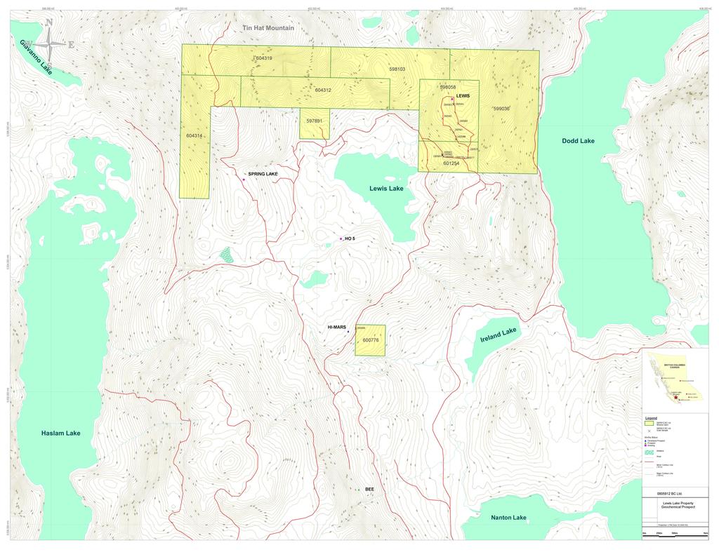
12 Claim Map Lewis Lake Property 5
13 Claim Map Lewis Lake Property Legend Exploration History The first significant exploration in the Powell River area was conducted in 1967 by American Smelting and Refining Company ( Asarco ). A 34 line kilometer induced polarization survey was conducted on the OK property located 20 km to the northwest of the Lewis Lake Property, Identifying five zones of anomalies polarization. To date follow up surveys and drilling conducted by numarour operators such as Noranda Exploration Company Ltd., Asarco Exploration Company of Canada Limited, Falconbridge Nickel Mines Ltd., Duval International Corporation, Granite Mountain Mines Ltd., Sierra Empire and Western Mines Ltd. have identified a total of eight mineralized zones. An Inferred Mineral Resource totaling 86.8 million tonnes grading 0.31% copper and 0.014% MoS 2 at a copper cutoff of 0.20% has been identified on the North Lake Zone of the OK Property. Ongoing exploration is being conducted by Eastfield Resources Ltd. Extensive exploration has also been conducted in the area of Lewis Lake both on the Lewis Lake property and adjacent tenures. In 1971 Hanna Mining Co. conducted geochemical soil sampling testing for copper mineralization on three grids located south of Lewis Lake in the area of the Hi Mars (092F 292) and Bee (092F 291) MINFile occurrences. In 1975 Newvan Resources Ltd. conducted further geochemical sampling between Lewis Lake and the prior surveys. All four surveys identified weak copper anomalies and the 1975 survey identified weak coincident molybdenum anomalies. In 1974 an extensive regional silt sampling program was conducted by W. Meyer & Associates Ltd., identifying the Lewis showing MINFile (092F 366) located on the current Lewis Lake property tenures. The following year an extensive exploration program was carried out by W. Meyer & Associates Ltd., on behalf of the Redonda Syndicate. The program consisted of a 6 km 2 geochemical survey, the blasting of 19 pits and extensive geological mapping. A general trend of copper anomalies was found to extend for 700 metres to the east from the main showing. 20 chip samples taken from 6 Blast hole located across a 120 metres stretch near the main showing consistently averaged 0.2% copper. In 1976 the area received attention from Rio Tinto which conducted an Induced Polarization and Resistivity survey in the area of the Spring Lake Showing MINFile (092F 369), on ground adjacent to the current Lewis Lake Property tenures. The survey defined a weak but shallow anomaly of low resistivity 6
14 trending east to west across three copper molybdenum showing. Based on this evidence 3 drill locations were recommended to test the anomaly. Subsequent reports in the area mention percussion drilling in the area but no results are given. In 1977 Rio Tinto continued its exploration with limited magnetometer work, geological mapping and the blasting of 24 pits. Although significant mineralization was encountered in the area, based on the work it was concluded: A large porphyry copper molybdenum ore body does not exist near surface in the vicinity of the Spring Lake showings. If reasonable grade mineralization exists at shallow depth under the blank area east of the showing, it is probably too small a size to be of interest. (ARIS 6433) Subsequently the option was dropped August 3, In 1978 follow up work on the Lewis Lake geochemical anomaly was carried out by Asarco. The program consisted of 23 blast pits within the copper anomaly identified in 1975 by W. Meyer & Associates Ltd. Although copper and molybdenum values were elevated they were lower than indicated by previous work. Additionally follow up geochemical soil sampling yielded lower than expected values. It was concluded that no significant economic deposit was associated with the geochemical anomaly although other economic concentrations of disseminated chalcopyrite and molybdenite may exist elsewhere beneath glacial cover on the claims. (ARIS 6989) In 1981 the property was acquired by Teck Corporation. Detailed geological mapping was conducted on the area of the Lewis Showing. The area was found to be underlay by diorite and quarts diorite which was intruded by frequent andesitic pyrite mineralized dykes. A fault or shear zone surrounded by a wide zone of secondary biotite alteration was located striking north northeast through the centre of the survey area. Although, it was assessed that the mineralized zones were too low in grade and too small in size to indicate local near surface economic mineralization. The showings suggest possible copper and molybdenum leakage from a leucocratic intrusive likely at depth. A VLF EM survey was recommended to define the fault and a magnetometer survey was recommended to define any potential leucocratic intrusion. A report written in 1990 for Edward R. Skrodolis described a program of geochemical stream sampling, a geophysical self potential ( SP ) survey and follow up blasting. The SP survey was designed to localize the source of geochemical copper and molybdenum anomalies located in 1975 by W. Meyer & Associates Ltd. The SP survey identified an approximate 500 metre diameter anomaly reading 200 millivolts or stronger in the area of 1975 geochemical anomalies. The results of the SP survey were described as contributing to the evidence of a porphyry copper system. Follow up blasting however did not identify economic mineralization in the area of the anomaly. Exploration Procedure The author and assistant traversed the Lewis Lake property in a 4x4 pickup truck. Prospective outcrops were noted for lithology, mineral composition, alteration and mineralization. Samples from prospective 7
15 outcrop were tagged and located with a Garmin Colorado 300 GPS device. Samples were analyzed at Pioneer Laboratories Inc. in Richmond, British Columbia. Samples were subjected to multi element ICP analysis and assay for Gold. Regional Geology The geology of the Powell River area is characterized by intrusive stocks of the Coast Crystalline Complex of Middle to upper Mesozoic age. Regionally the most common rock unit is granodiorite, with diorite and quartz diorite occurring as stocks within the granodiorite. The dioritic complex is predominant in an approximate 125 km wide belt running northwest between the Strait of Georgia and Lillooet River. Individual intrusive units of the complex tend to intrude parallel to the regional belt where narrow andesitic dykes, may locally contain roof pendants of older volcanics. Claim Geology The claim group is situated in the Coast Crystalline Complex and is underlain by plutonic rocks consisting of quartz diorite and diorite. Narrow, scattered remnants of andesite are positioned throughout the claim area. Whether these andesite masses are inclusions (pendant remnants) or are transecting features (dykes) is not known. However, pyrite mineralization is closely associated with andesite in contact with quartz diorite. Mineralization The main mineralization is chalcopyrite and pyrite which occur mostly as sparse dissemination and veinlet in the granodiorite, quartz diorite and dark fine grained diorite. Pyrite is abundant in these rocks. Minor molybdenite was noted with veinlet quartz and in the fractures. Malachite can be seen on some fracture surfaces. Sample Geochemistry 14 rock samples were taken from the property during the on site visit in July The copper and molybdenum assay results of these samples are summarized below: SAMPLE Cu Mo ppm ppm Sample Description Fine grained diorite with disseminated, stringered and veinleted pyrite quartz vein diorite with disseminated pyrite granodiorite with disseminated pyrite silicified granodiorite with minor malachite 8
16 dark fine grained diorite with minor disseminated pyrite and chalcopyrite quartz vein (14cm in width) in diorite grey medium grained diorite with minor pyrite in the fractures grey granodiorite with significant molybdenite and chalcopyrite mineralization, molydbdenite occurs as dissemination and patches in the fractures diorite and granodiorite with minor dissemniated pyrite dark fine grained diorite with disseminated and stringered pyrite and chalcopyrite quartz vein with rusty surface granodiorite with rusty surface granodiorite with minor pyrite and chalcopyrite Conclusion and Recommendations Inspection of the outcrops in the property areas indicates the presence of sparse chalcopyrite and minor molybdenite. Chalcopyrite is associated with the granodiorite, quartz diorite and dark fine grained diorite. Pyrite is abundant in these rocks. Minor molybdenite occurs in veinlet quartz and in the fractures of granodiorite. Potential for economic mineralization at depth is suggested by the significant grades obtained in grab samples and the encouraging historical geological mapping and geophysical work identifying coincident anomalies. It is recommended that additional prospecting be carried out in the area of samples through to identify the extent of mineralization on surface, followed by limited but deep drilling to test for more extensive mineralization at depth. 9
17
18 References Schuur, W., & Irvine, J.R., 1967: B.C. Assessment Report #1573, Report on Induced Polarization Survey in the Powell River Area, BC for ASRCO Exploration Company of Canada Limited Bullis, A. R., 1971: B.C. Assessment Report #3489, Report on Dodd lake Property Bullis, A. R., 1971: B.C. Assessment Report #3549, Report on Dodd lake Property Bullis, A. R., 1971: B.C. Assessment Report #3550, Report on Dodd lake Property Meyer, W., 1975: B.C. Assessment Report #5798, Geological and Geochemical report on the In and Ho claims groups, Lewis Lake, Powell River area Meyer, W., 1975: B.C. Assessment Report #5844, Geological and Geochemical report on the Lewis claim group, Powell River area Hodgson, G.D., 1977: B.C. Assessment Report #6433, Geological Report on the Spring Lake Group, Powell River Area Fletcher, D.M., 1978: B.C. Assessment Report #6989, Pitting and Geochemical Survey Lewis Claim Group Betmanis, A.I., 1981 : B.C. Assessment Report #9948, Geological Mapping of the Beach Claim (Lewis Lake) Perry, A.R., 1990: B.C. Assessment Report #20348, Geochemical and Geophysical Report on the Lewis Lake Group MINFILE 092K
19 Total Project Expenditure Total expenditures on the Lewis Lake Property are listed in this cost statement. Costs are proportionately divided between groups of adjacent tenures in the next two cost statements as described in the next two cost statments. Numbers may not add due to rounding. Personnel Name Position Date Description No. Units Rate Subtotal Dr. Jon Pan Geologist 21-Jul-09 Field mapping and Sampling 12 Hours Jul-09 Field mapping and Sampling 14 Hours Peter Palikot Prospector 21-Jul-09 Field mapping and Sampling 12 Hours Jul-09 Field mapping and Sampling 14 Hours , Office Studies From Description No. Units General research Dr. Jon Pan Geologist 17-Jul-09 Historical data review 4 Hours Peter Palikot Prospector 17-Jul-09 Literature search 8 Hours Report preparation & Database compilation Dr. Jon Pan Geologist 15-Jan-10 1 ARIS Report 1, , Geochemical Analysis Description No. Units Rate Subtotal Pioneer Laboratories Cu Analysis 2.0 Samples Au Analysis 20 gm Samples ICP Analysis Samples Rock Sample Preparation Samples Assay Tag Books 1.00 Units Ties Units ml 12" X 20" sample bags Units
20 Transportation Description No. Units Rate Subtotal BC Ferry Comox to Powell River Saltry Bay to Earls Cove Kilometers Kilometers Accommodation & Food From To Subtotal Hotel 21-Jul Jul Meals 21-Jul Jul Miscellaneous Handling Fee TOTAL Expenditures 4,463.03
21 Total Project Expenditure on Tenure & Approximately 24 hours were spent prospecting and 14 samples were taken from the tenure & this represents approximately 90% of the total cost of field time and laboratory analysis for the total Lewis Lake Property. Accordingly approximately 10% all other costs such as food, lodging, travel research and report writing were allocated to this and adjacent tenures. Personnel Name Position Date Description No. Units Rate Subtotal Dr. Jon Pan Geologist 21-Jul-09 Field mapping and Sampling 11 Hours Jul-09 Field mapping and Sampling 13 Hours Peter Palikot Prospector 21-Jul-09 Field mapping and Sampling 11 Hours Jul-09 Field mapping and Sampling 13 Hours , Office Studies From Description No. Units General research Dr. Jon Pan Geologist 17-Jul-09 Historical data review 3.6 Hours Peter Palikot Prospector 17-Jul-09 Literature e search 7.2 Hours Report preparation & Database compilation Dr. Jon Pan Geologist 15-Jan ARIS Report ,267.20
22 Geochemical Analysis Description No. Units Rate Subtotal Pioneer Laboratories Cu Analysis 2.0 Samples Au Analysis 20 gm Samples ICP Analysis Samples Rock Sample Preparation Samples Assay Tag Books 0.90 Units Ties Units ml 12" X 20" sample bags Units Transportation Description No. Units Rate Subtotal BC Ferry Comox to Powell River Saltry Bay to Earls Cove Kilometers Kilometers Accommodation & Food From To Subtotal Hotel 21-Jul Jul Meals 21-Jul Jul Miscellaneous Handling Fee TOTAL Expenditures 4,072.78
23 Total Project Expenditure on Tenure Approximately 2 hours were spent prospecting and 1 sample was taken from the tenure , this represents approximately 10% of the total cost of field time and laboratory analysis for the total Lewis Lake Property. Accordingly approximately 10% all other costs such as food, lodging, travel research and report writing were allocated to this and adjacent tenures. Personnel Name Position Date Description No. Units Rate Subtotal Dr. Jon Pan Geologist 21-Jul-09 Field mapping and Sampling 1 Hours Jul-09 Field mapping and Sampling 1 Hours Peter Palikot Prospector 21-Jul-09 Field mapping and Sampling 1 Hours Jul-09 Field mapping and Sampling 1 Hours Office Studies From Description No. Units General research Dr. Jon Pan Geologist 17-Jul-09 Historical data review 0.40 Hours Peter Palikot Prospector 17-Jul-09 Literature search 0.80 Hours Report preparation & Database compilation Dr. Jon Pan Geologist 15-Jan ARIS Report
24 Geochemical Analysis Description No. Units Rate Subtotal Pioneer Laboratories Au Analysis 20 gm 1.00 Samples ICP Analysis 1.00 Samples Rock Sample Preparation 1.00 Samples Assay Tag Books 0.10 Units Ties 2.00 Units ml 12" X 20" sample bags 2.00 Units Transportation Description No. Units Rate Subtotal BC Ferry Comox to Powell River 5.41 Saltry Bay to Earls Cove Kilometers Kilometers Accommodation & Food From To Subtotal Hotel 21-Jul Jul Meals 21-Jul Jul Miscellaneous Handling Fee 4.24 TOTAL Expenditures
25
26
NEW HAZELTON, OMINECA M.D.,
 PROSPECTING REPORT JUDI 1 TO 6 MINERAL CLAIMS NEW HAZELTON, OMINECA M.D., B.C. MAP 93M/4E, LAT. SS014'N, LONG. 127'33'W OWNED BY: A. L'ORSA ANTHONY L'ORSA Smithers, B.C. 21 February, 1981 TABLE OF CONTENTS
2013 GEOLOGICAL ASSESSMENT REPORT SHERIDAN HILL PROPERTY
 2013 GEOLOGICAL ASSESSMENT REPORT ON THE SHERIDAN HILL PROPERTY NEW WESTMINSTER MINING DIVISION BRITISH COLUMBIA NTS 092G07 49 16 31 NORTH LATITUDE, 122 39 48 WEST LONGITUDE PREPARED FOR Sheridan Hill
SECOND and THIRD YEAR ASSESSMENT REPORT PROSPECTING LICENCE M, ROCK CUT PROPERTY, NTS 1N/12, NEWFOUNDLAND. ROY FRENCH (licence holder )
") SECOND and THIRD YEAR ASSESSMENT REPORT Of PROSPECTING On LICENCE 013704M, ROCK CUT PROPERTY, NTS 1N/12, NEWFOUNDLAND. By ROY FRENCH (licence holder ) Work Conducted: Sept. 17, 2008 Nov. 03, 2009 Total
SECOND and THIRD YEAR ASSESSMENT REPORT Of PROSPECTING On LICENCE 013704M, ROCK CUT PROPERTY, NTS 1N/12, NEWFOUNDLAND. By ROY FRENCH (licence holder ) Work Conducted: Sept. 17, 2008 Nov. 03, 2009 Total
GEOLOGICAL MAPPING REPORT ON THE ASH MINERAL CLAIM OSOYOOS MINING DIVISION ASHNOLA RIVER MAP SHEET NTS M092,H019 MCBRIDE CREEK AREA, ASHNOLA RIVER,
 GEOLOGICAL MAPPING REPORT ON THE ASH MINERAL CLAIM OSOYOOS MINING DIVISION ASHNOLA RIVER MAP SHEET NTS M092,H019 LATITUDE 49 o O6, LONGITUDE 120 o 22 MCBRIDE CREEK AREA, ASHNOLA RIVER, KEREMEOS, B.C. CANADA
The Cobalt Rainbow. Airborne geophysical maps show that a north trending aeromagnetic high suggests further undiscovered mineralisation.
 The Cobalt Rainbow The property is located on Greenstone Creek, approximately 4.8 kilometres south west of the creek mouth. The property is located about 24 km due west of Campbell River, in the east-central
for the Greenwood Mining Division, B.C. NTS 82E/7W Latitude 49' 27' W, Longitude 118' 5 Prepared by a= D. Dylan Watt, B.Sc.
 t. b LOGnO: 37~ -08 m. ACTIO#: for the AMP AMP 2 AMP 3 t AMP 4 CLAIMS Greenwood Mining Division, B.C. NTS 82E/7W Latitude 49' 27' W, Longitude 8' 5 %E c,w zc *& a w Prepared by a= -4c. D. Dylan Watt, B.Sc.
PROSPECTORS ASSISTANCE PROGRAM MINISTRY OF ENERGY AND MINES
 BRITISH COLUMBIA PROSPECTORS ASSISTANCE PROGRAM MINISTRY OF ENERGY AND MINES GEOLOGICAL SURVEY BRANCH PROGRAM YEAR: 1999/2000 REPORT #: PAP 99-l 6 NAME: KIM ANSCHETZ PROSPECTORS TlEPORT on the 99 LOUIS
ASX Announcement. 28 January Drill results indicate large Porphyry Copper Gold System at Peenam
 ASX Announcement 28 January 2010 Drill results indicate large Porphyry Copper Gold System at Peenam Highlights: 270 metres of visible copper (gold) mineralisation in first diamond core hole at Peenam Prospect
for the Greenwood Mining Division, B.C. NTS 82E/7W 29' W, Longitude 118' 53' N Prepared by D. Dylan Watt, B.Sc.
 for the FltE NO: u VOLT 1, VOLT 2, VOLT 3, & VOLT 4 CLAIMS Greenwood Mining Division, B.C. NTS 82E/7W Latitude 49' 29' W, Longitude 118' 53' N Prepared by D. Dylan Watt, B.Sc. #309-1996 Trutch Street Vancouver,
ASSESSMENT REPORT ON THE PEAVINE PROJECT. DGW & Associates # Alberni Street, Vancouver, British Columbia, V6E 4V2
 ASSESSMENT REPORT ON THE PEAVINE PROJECT KAMLOOPS MINING DIVISION BRITISH COLUMBIA NTS 082M 12 Latitude 51 36' 19.0"North -- Longitude --119 47' 27.0"West UTM Zone 11, NAD 83 5720827N 306744E Prepared
CONTENTS. Location, Access and History...6. Tenure Status and Geology Regional Andy Property Geology Map...9
 TYPE OFWORK IN THIS REPORT EXTENT OF WORK (rn METRTC UNITS) ON WHICH CLAIMS PROJECT COSTS APPORTIONED (incl. support) GEOLOGICAL (scale, area) Ground, mapping Photo interpretation GEOPHYSICAL (line-kilometres)
ROCK AND DRILL CORE GEOCHEMICAL SAMPLING ON THE GAMBIER ISLAND PORPHYRY COPPER PROJECT VANCOUVER MINING DIVISION
 ROCK AND DRILL CORE GEOCHEMICAL SAMPLING ON THE GAMBIER ISLAND PORPHYRY COPPER PROJECT VANCOUVER MINING DIVISION NTS: 092G.054 Latitude 45 6 7.2 N Longitude 123 21 35.6 W Prepared by: R.M. (Rudi) Durfeld,
Prospecting Report 'S Office i DB Property, B.C. -J Negro Creek Nelson Mining District NTS 82F.050. Operator: Kootenay Gold Inc.
 . '.' I"' i9 12 Prospecting Report 'S Office i DB Property, B.C. -J Negro Creek Nelson Mining District NTS 82F.050 Operator: Kootenay Gold Inc. Owner: Darlene Lavoie Work Performed Summer of 2007 Report
DSM SYNDICATE DISCOVERS POLYMETALLIC MINERALIZATION WITH TALUS GRAB SAMPLES CONTAINING UP TO PERCENT LEAD AND 18
 DSM SYNDICATE DISCOVERS POLYMETALLIC MINERALIZATION WITH TALUS GRAB SAMPLES CONTAINING UP TO 92.8 GRAMS PER TONNE GOLD, 13,643 GRAMS PER TONNE SILVER, 13.85 PERCENT LEAD AND 18.65 PERCENT COPPER FROM DIFFERENT
Elverdton Copper-Gold Project Ravensthorpe, Western Australia
 FOR SALE or JV Elverdton Copper-Gold Project Ravensthorpe, Western Australia Summary: The Elverdton Copper-Gold Project is located approximately 11 kilometres south-east of Ravensthorpe town, which is
BALFOUR MINING LTD. (N.P.L.) HAM GROUP 92-P-6, CLINTON M. D.8 B. C. Lat 51 17'N, GEOCHEMICAL REPORT. V. CUKOR, P. Eng.
 HAM GROUP 92-P-6, CLINTON M. D.8 B. C. Lat 51 17'N, GEOCHEMICAL REPORT. V. CUKOR, P. Eng.") 34q '7 BALFOUR MINING LTD. (N.P.L.) HAM GROUP 92-P-6, CLINTON M. D.8 B. C. Lat 51 17'N, Long 12lo14'W GEOCHEMICAL REPORT, V. CUKOR, P. Eng. January 31, 1972 TABLE OF CONTENTS 1. INTRODUCTION 2. PROPERTY,
34q '7 BALFOUR MINING LTD. (N.P.L.) HAM GROUP 92-P-6, CLINTON M. D.8 B. C. Lat 51 17'N, Long 12lo14'W GEOCHEMICAL REPORT, V. CUKOR, P. Eng. January 31, 1972 TABLE OF CONTENTS 1. INTRODUCTION 2. PROPERTY,
CREATING VALUE THROUGH DISCOVERY IN SOUTH AMERICA. Lara Copper Project. Lara 45%-Owned Property in Southern Peru
 CREATING VALUE THROUGH DISCOVERY IN SOUTH AMERICA Lara Copper Project Lara 45%-Owned Property in Southern Peru 1 Forward Looking Statements Except for statements of historical fact relating to the Company,
PROSPECTING REPORT. Medallion Property. EVENT # TENURE # Tenure Name: GPEX CLVIII Medallion
 2006-2007 PROSPECTING REPORT Medallion Property EVENT # 4167980 TENURE # 540362 Tenure Name: GPEX CLVIII Medallion Watson Bar Region Clinton Mining Division Map 092O Central Coordinate Reference Long.
1 CLAIMS GEOPHYSICAL REPORT ON BOYAL SITUATE NORTHEAST OF TILLICUM MOUNTAIN GOLD AREA BURTON - NAKUSP SIQCAEJ MINING DIVISION
 GEOPHYSICAL REPORT ON BOYAL 1 CLAIMS SITUATE NORTHEAST OF TILLICUM MOUNTAIN GOLD AREA BURTON - NAKUSP SIQCAEJ MINING DIVISION CONSULTING GEOLOGIST AUGUST 1983 VANCOUVER B *C INDEX INTRODUCTION ooa,.eoaaa.aaaoaaooaoa~ao~o
UNION MINIERE EXPLORATIONS AND MINING CORPORATION LIMITED ASSESSMENT REPORT ON FITINAT MINERAL CLAIM. Alberni Mining Division Record No.
 M F )( UNION MINIERE EXPLORATIONS AND MINING CORPORATION LIMITED Suite 200, 4299 Canada Way, Burnaby, B.C. V5G 1 H4 Telephone (604) 437-9491 ASSESSMENT REPORT ON GEOCHEMICAL SOIL SURVEYS AND ROCKSAMPLING
The MAPLE BAY PROJECT Copper Silver - Gold
 The MAPLE BAY PROJECT Copper Silver - Gold Good grade and tonnage potential within close proximity to Tidewater The Maple Bay Copper Silver Gold Project covers highly favourable geological host rocks of
PROSPECTING REPORT THE WALLACE CLAIM OMENICA MINING DIVISION. 54" x6" 3.d d. for. Reako Exlorat ions Ltd. Wallace Rev. C.G.
 PROSPECTING REPORT ON THE WALLACE CLAIM OMENICA MINING DIVISION 54"44 14 1x6" 3.d d by David A. Howard P.Eng. for Reako Exlorat ions Ltd. Claim Locat ion Wallace Rev. C.G. #1560 Dome Mountain Area 9 3
HOWE COPPER MINE PROJECT HIGH GRADE Cu-Ag with Au
 HOWE COPPER MINE PROJECT HIGH GRADE Cu-Ag with Au The Howe Copper Mine property is located approximately 55 kilometres northwest of Vancouver, BC. It is situated at 1431 metres elevation on the eastern
DISCOVERY OF MINERALISED PORPHYRY & MAGNETITE-COPPER-GOLD AT KAMARANGAN
 MEDUSA MINING LIMITED ABN: 60 099 377 849 Unit 7, 11 Preston Street Como WA 6152 PO Box 860 Canning Bridge WA 6153 Telephone: +618-9367 0601 Facsimile: +618-9367 0602 Email: admin@medusamining.com.au Internet:
lat ' N Long ' W
 305 7 ec1;, REPORT ON THE JERY CLAIMS OF POLA RESOURCES LTD. NTS 93L/16 0 0 lat. 54 45' N Long. 126 22' W BABIXE LAKE AREA OMINECA MINING DIVISION, B.C. PAUL PLICKA CONSULTING GEOLOGIST DECEMBER 30, 1981
ASSESSMENT REPORT TITLE PAGE AND SUMMARY
 ASSESSMENT REPORT TITLE PAGE AND SUMMARY TITLE OF REPORT: 2016 Prospecting Report Midas Claim TOTAL COST: $314.61 AUTHOR(S): Giacomo Grassi SIGNATURE(S): NOTICE OF WORK PERMIT NUMBER(S)/DATE(S): STATEMENT
PROSPECTING REPORT. Broken Hill Property. EVENT # TENURE # Tenure Name: Broken Hill. New Westminster Mining Division Map 092H
 2009-2010 PROSPECTING REPORT Broken Hill Property EVENT # 4514071 TENURE # 600988 Tenure Name: Broken Hill New Westminster Mining Division Map 092H Central Coordinate Reference 121 24 26.2 W Longitude
Queensland Mining Corporation Limited
 Queensland Mining Corporation Limited ABN 61 109 962 469 ASX Release 29 th July 2011 Drilling Commenced at Duck Creek Copper-Gold Project, Cloncurry, North-west Queensland Highlights RC drilling has commenced
CARIBOO - GRIZZLY ZINC PROJECT
 CARIBOO - GRIZZLY ZINC PROJECT The Grizzly Lake or Cariboo Zinc property straddles the gravel Weldwood 8400 logging road in the Grizzly Lake area about 55 kilometres northeast of Likely. Roads constructed
Summary of Rover Metals Geologic Mapping Program at the Up Town Gold Project, Northwest Territories
 October 13, 2017 Summary of Rover Metals Geologic Mapping Program at the Up Town Gold Project, Northwest Territories Vancouver, British Columbia, Canada - Rover Metals Corp., Rover, is pleased to provide
PIOTR LUTYNSKI VANCOUVER, BRITISH COLUMBIA
 AN ASSESSMENT REPORT ON GROUND MAGNETIC SURVEYING CHUCHI PROPERTY FORT ST. JAMES AREA, BRITISH COLUMBIA OMINECA M.D. 55 17 N, 124 31 W NTS 93N/ 7&8 Claims Surveyed: 597976, 597878-597880 Survey Dates:
7 MILES WEST OF PORT HARDY, B.C.
 GEOPHYSICAL REPORT VERTICAL INTENSITY MAGNETOMEER SURVEY ON LUK CLAIMS, 7 MILES WEST OF PORT HARDY, B.C. 50' 127O SE BY R. E. SHIELDS UNDER SUPERVISION OF J. R. BILLINGSLEY FOR SECOND0 MINING LTD. (N.
FANCAMP EXPLORATION LTD.
 FANCAMP EXPLORATION LTD. Fancamp Exploration Ltd. Overview of Ontario Projects Prepared by: J. Kleinboeck, P.Geo. August 4 th, 2018 Dorothy Lake Project Comprised of 104 unpatented claims covering an
A GUIDE TO WRITING AN ASSESSMENT REPORT ON YOUR CLAIMS
 A GUIDE TO WRITING AN ASSESSMENT REPORT ON YOUR CLAIMS PLEASE NOTE! In the following pages, suggestions and advice are in italics, under each heading. Use as a guideline only. Items in bold should be changed
T'he Horn property comprises a group of forty. contiguous claims owned by Canadian Superior Exploration
 -1- INTRODUCTION T'he Horn property comprises a group of forty contiguous claims owned by Canadian Superior Exploration Limited. The group is located five miles nort'h of Motase Lake. In July and August,
SOUTHWEST & NORTHWEST EXPLORATION PROJECTS BINGHAM CANYON MINING DISTRICT
 SOUTHWEST & NORTHWEST EXPLORATION PROJECTS BINGHAM CANYON MINING DISTRICT SALT LAKE AND TOOELE COUNTIES, UTAH SUMMARY FRIDAY, MARCH 20, 2009 1 Tooele County Salt Lake County GOOGLE EARTH September, 2006
A New Direction. Copper-Gold Deposit at Thor TSX.V:COL. August 11, May 2013
 A New Direction Copper-Gold Deposit at Thor August 11, 2016 May 2013 TSX.V:COL FORWARD LOOKING STATEMENTS This presentation includes certain forward-looking information or forward-looking statements for
SIMUKU DRILLING TO OVER 1000 METRES DEMONSTRATES SIGNIFICANTLY INCREASED TONNAGE POTENTIAL OF THE INFERRED RESOURCE
 ADDRESS PHONE PO Box 6965 +61(07) 5592 1001 Gold Coast Mail Centre FAX Qld 9726 Australia +61 (07) 5592 1011 EMAIL ABN 54 126 490 855 info@coppermoly.com.au WEBSITE www.coppermoly.com.au ASX Announcement
News Release No GOLD AND COPPER MINERALIZATION DISCOVERED DURING PHASE 2 EXPLORATION AT THE MCBRIDE PROPERTY
 November 19, 2018 TSX Venture Exchange Listed Frankfurt Exchange Listed News Release No. 303-2018 GOLD AND COPPER MINERALIZATION DISCOVERED DURING PHASE 2 EXPLORATION AT THE MCBRIDE PROPERTY Vancouver,
LINGIG PORPHYRY COPPER DISCOVERY
 MEDUSA MINING LIMITED ABN: 60 099 377 849 Unit 7, 11 Preston Street Como WA 6152 PO Box 860 Canning Bridge WA 6153 Telephone: 618-9367 0601 Facsimile: 618-9367 0602 Email: admin@medusamining.com.au Internet:
FIRST YEAR ASSESSMENT REPORT PROSPECTING LICENCE 16512M MARYSTOWN AREA, BURIN PENINSULA NTS 1M/3
 FIRST YEAR ASSESSMENT REPORT OF PROSPECTING ON LICENCE 16512M MARYSTOWN AREA, BURIN PENINSULA NTS 1M/3 BY NATHANIEL NOEL MSc. FOR E. MICHELE NOEL MINERAL LICENCES: 16512 M WORK CONDUCTED: MID-SEPTEMBER
Serengeti Resources Inc GEOCHEMICAL REPORT ON THE SHADOW PROPERTY a.
 Serengeti Resources Inc. 2004 GEOCHEMICAL REPORT ON THE SHADOW PROPERTY a. Located in the Johanson Lake Area Omenica Mining Division NTS 94D/9 6 degrees and 32 minutes North Latitude 126 degrees and 2
NTS 082F03SW N W U E N
 Prospecting Report JOCELYN CLAIM NTS 082F03SW N49 09 51 W 117 14 04 11U 482906E 5445737N NELSON MINING DIVISION Martin Ross PO Box 323 Salmo BC V0G 1Z0 Jan 31, 2012 PROSPECTING REPORT JOCELYN MINERAL CLAIM
DÉCOUVERTE Positioned for Discovery in James Bay, Quebec. Investor Presentation, January 2018 by Danae Voormeij, MSc, PGeo
 DÉCOUVERTE Positioned for Discovery in James Bay, Quebec Investor Presentation, January 2018 by Danae Voormeij, MSc, PGeo Location Maps and Infrastructure Location: Durango Resources 100% owned Découverte
1 FILMED 1. FILE NO:!..rsrru -* -. GRAND TWO CLAIM
 FILE NO:!..rsrru -* -. GRAND TWO CLAIM REPORT ON 1993 ASSESSMENT WORK GRAND TWO CLAIM REC. NO. 301849 NELSON MINING DIVISION NTS MAP SHEET 82F6/W 49 25'51" NORTH 117 18'08" WEST 1 FILMED 1 AUTHOR: R. Jordan,
ASSESSMENT REPORT TITLE PAGE AND SUMMARY
 ASSESSMENT REPORT TITLE PAGE AND SUMMARY TITLE OF REPORT: 2016 Prospecting Report Sphynx Claim TOTAL COST: $167.56 AUTHOR(S): Giacomo Grassi SIGNATURE(S): NOTICE OF WORK PERMIT NUMBER(S)/DATE(S): STATEMENT
Reconnaissance. Of the. Denis mineral claims. Situated at Kilometer 844 of the Alaska Highway. Liard Mining Division. Northeastern British Columbia
 Reconnaissance Of the Denis mineral claims Situated at Kilometer 844 of the Alaska Highway Liard Mining Division Northeastern British Columbia N.T.S. 94M.075 Latitude 59 42 25 Longitude 127 13 12 Field
For personal use only
 ANNOUNCEMENT TO THE AUSTRALIAN SECURITIES EXCHANGE: 28 NOVEMBER 2012 DRILLING UPDATE MABILO PROJECT The Directors of Sierra Mining Limited ( Sierra ) are pleased to announce further results from reconnaissance
ENCOURAGING GOLD-BASE METALS AT MAY DAY, MOLY- GOLD AT ATTUNGA
 ASX / MEDIA RELEASE 5 JULY 2010 ENCOURAGING GOLD-BASE METALS AT MAY DAY, MOLY- GOLD AT ATTUNGA Peel Exploration is pleased to announce that recent drilling at the Company s Attunga and May Day projects
ASSESSMENT REPORT MAGNETOMETER SURVEY GOLDEN ROD, GOLDEN ROD #2. Long.: General Delivery, Vananda, B. C.
 ASSESSMENT REPORT MAGNETOMETER SURVEY GOLDEN ROD, GOLDEN ROD #2 t=/ NTS 92~110w Lat.: Long.: 49O 44' N 124O 34' W Owner: E. Johanson General Delivery, Vananda, B. C. Operator: Rhyolite Resources I nc.
NEWS RELEASE. Empire Mining Corporation 1090 Hamilton Street Vancouver, B.C. V6B 2R9
 Empire Mining Corporation 1090 Hamilton Street Vancouver, B.C. V6B 2R9 Phone: (604) 634-0970 Fax: (604) 634-0971 Toll Free: 1 888 818-1364 info@empireminingcorp.com www.empireminingcorp.com NEWS RELEASE
REPORT. on the. Omineca Mining Division, British Columbia. Latitude N., Longitude W. NTS map sheet 93F/7E. James W. McLeod, P.Geo.
 REPORT on the CHU MOLYBDENUM PROPERTY Omineca Mining Division, British Columbia Latitude 53 21 N., Longitude 124 37 W. NTS map sheet 93F/7E James W. McLeod, P.Geo. on behalf of Mr. Chris Delorme TABLE
GEOPHYSICAL REPORT. Airborne Magnetometer Survey. of the SHEEP-GOAT GROUP OF MINERAL CLAIMS. near Li l looet, B.C.
 GEOPHYSICAL REPORT 977 Airborne Magnetometer Survey of the SHEEP-GOAT GROUP OF MINERAL CLAIMS near Li l looet, B.C. Lillooet Mining Division (Lat.51 'lot Long. 122 40' 7 5t0[2L05E. for DUFFEY LAKES MINES
Mountain Maid Gold System Displays Major Size Potential
 29 July 2008 The Manager, Companies Australian Securities Exchange Ltd Electronic Announcement System Dear Sir, AXIOM MINING LIMITED (ASX CODE: AVQ) ASX Announcement Mountain Maid Gold System Displays
TOPOGRAPHICAL SURVEY REPORT ON THE GREENDROP PROPERTY NEAR CHILLIWACK, B.C. 92-H-3/W
 TOPOGRAPHICAL SURVEY REPORT ON THE GREENDROP PROPERTY NEW WESTMINSTER M.D. NEAR CHILLIWACK, B.C. 92-H-3/W Location: The central pap of the claims is located at coordinates 49 08'N, latitude by 121 26'W,
PROSPECTING REPORT. Silver Dollar Property. EVENT # TENURE # Tenure Name: GPEX Silver Dollar
 2008-2009 PROSPECTING REPORT Silver Dollar Property EVENT # 4267989 TENURE # 555462 Tenure Name: GPEX Silver Dollar Similkameen Mining Division Map 092H Central Coordinate Reference 120 06 26.9 W Longitude
O ITHIS )WE OF WORK IN I EXTENT OF WORK I I PROJECT COSTS I ON WHICH CLAIMS (IN METRIC UNITS) APPORTIONED (id. support) GEOLOGICAL (scale, area)
WE OF WORK IN I EXTENT OF WORK I I PROJECT COSTS I ON WHICH CLAIMS (IN METRIC UNITS) APPORTIONED (id. support) GEOLOGICAL (scale, area)") Geological Survey Branch TITLE OF REPORT [type of SUNOY(S)] TOTAL COST 1 MINERAL INVENTORY M OWNER@) MAILING ADDRESS -.,-- a 5 -a OPERATOR(S) [who paid ffo the wnk) 2) MAILING ADDRESS 76e2 HWY 97/gm LP
Geological Survey Branch TITLE OF REPORT [type of SUNOY(S)] TOTAL COST 1 MINERAL INVENTORY M OWNER@) MAILING ADDRESS -.,-- a 5 -a OPERATOR(S) [who paid ffo the wnk) 2) MAILING ADDRESS 76e2 HWY 97/gm LP
First Year assessment Report on Prospecting and Rock sampling, King George property, License M NTS 12A/05 Newfoundland and Labrador.
 First Year assessment Report on Prospecting and Rock sampling, King George property, License 016679M NTS 12A/05 Newfoundland and Labrador. Submitted by Shawn Rose For Shawn Rose January 2011 Work year
RECONNAISSANCE GEOCHEMICAL SURVEY
 RECONNAISSANCE GEOCHEMICAL SURVEY LEGAL, RITA, LOUISE FR. (CHAPLEAU GROUP) REVERTED CROWN GRANTS CHAPLEAU CREEK AREAJ, SLOC& MINING DIVISION 82 F/11W Lat: 49'44" Long: 117"22'W MINERAL RESOURCES BRANCH
Focus Acquires Porphyry Copper-Molybdenum Project, Peru; Historical Drilling includes 0.57% Cu and 0.7% Cu
 Focus Acquires Porphyry Copper-Molybdenum Project, Peru; Historical Drilling includes 190m @ 0.57% Cu and 71.7m @ 0.7% Cu July 11, 2012; Vancouver, Canada: Focus Ventures Ltd. (TSX-V: FCV) is pleased to
Tameapa Regional Geology
 Tameapa Project 1 Tameapa Regional Geology History San Francisco Mines of Mexico Ltd. (San Francisco), which completed an exploration program, including six drill holes (1,157 m) between 1956 and 1959.
GEOLOGIC SETTING OF THE WADSWORTH VEIN: AN INTRUSIVE-RELATED GOLD DISCOVERY NEAR TERRACE, B.C.
 WADSWORTH VEIN By Paul J. Wojdak, Wayne Bulmer and Daryl J. Hanson LOCATION: Lat. 54 57 33 N Long. 128 50 09 W (103I/15W) CLAIMS: ACCESS: SKEENA MINING DIVISION. The property is located in the Cedar River
Drilling program commences on Cloncurry and Mount Isa projects
 1P P May UASX/Media Announcement st 2009 Drilling program commences on Cloncurry and Mount Isa projects Key Points 1,700 metres reverse circulation drilling program over two prospects on untested geochemical,
EXPLOR INTERSECTS MULTIPLE COPPER ZONES GRADES UP TO 3.65% CU OVER 5.35 METERS ON THE CHESTER COPPER PROPERTY
 15 Gamble East Street - Suite 204 - Rouyn-Noranda (Canada) J9X 3B6 Listing (TSX-V = EXS) (OTCQB = EXSFF) (FSE & BE = E1H1) EXPLOR INTERSECTS MULTIPLE COPPER ZONES GRADES UP TO 3.65% CU OVER 5.35 METERS
Revelo Defines Porphyry Copper Targets at its Calvario Project
 www.reveloresources.com NEWS RELEASE #01/2015 Revelo Defines Porphyry Copper Targets at its Calvario Project Vancouver - February 03, 2015 - Revelo Resources Corp. ( Revelo or the Company ) (TSX-V: RVL)
MARKET UPDATE ON URANIUM AND GOLD PROJECTS
 ASX Announcement 1 March 2011 MARKET UPDATE ON URANIUM AND GOLD PROJECTS HIGHLIGHTS 5,000 metre drilling programme to commence at Rio Puerco uranium project within the next two weeks. Drilling to commence
Drilling Program Commences on Iron Oxide Copper Gold Targets
 3 June 2008 Manager Company Announcements Company Announcements Office Australian Stock Exchange Limited Level 10, 20 Bond Street SYDNEY NSW 2000 ABN 42 082 593 235 Electronic delivery No of pages: 6 Drilling
Daiwan Engineering Ltd Granville strees V.ncouver, B. C. cuudr WY 1GS. M e : (604) PROSPECTING REPORT ON THE KING MINERAL CLAIMS
 PROSPECTING REPORT ON THE KING MINERAL CLAIMS") 1030-609 Granville strees V.ncouver, B. C. cuudr WY 1GS M e : (604) 688-1508 PROSPECTING REPORT ON THE KING MINERAL CLAIMS NORTH VANCOUVER ISLAND, BRITISH COLUMBIA NTS: 92Lj13E Latitude: 50" 47' Longitude:
1030-609 Granville strees V.ncouver, B. C. cuudr WY 1GS M e : (604) 688-1508 PROSPECTING REPORT ON THE KING MINERAL CLAIMS NORTH VANCOUVER ISLAND, BRITISH COLUMBIA NTS: 92Lj13E Latitude: 50" 47' Longitude:
The McPhillamys Gold Deposit, Discovery History & Geology. Presenter: Tara French
 The McPhillamys Gold Deposit, Discovery History & Geology. Presenter: Tara French Forward-Looking Statements This presentation contains forward-looking statements. without limitation: Estimates of future
Narrow High-Grade Gold and Long Low-Grade Porphyry Gold and Copper-Gold Intercepts at Bulago
 CONTACTS PHONE EMAIL PO Box 52 +61 (08) 9295 0388 info@frontierresources.com.au West Perth FAX WEBSITE WA 6872 Australia +61 (08) 9295 3480 www.frontierresources.com.au ASX Limited Company Announcements
ASSESSMENT REPORT PROSPECTING PROGRAM ION/DIRTY JACK PROPERTY NELSON MINING DIVISION N.T.S. MAP SHEET 82F.023 UTM COORDINATES N E
 ASSESSMENT REPORT PROSPECTING PROGRAM ION/DIRTY JACK PROPERTY NELSON MINING DIVISION N.T.S. MAP SHEET 82F.023 UTM COORDINATES 5454800N - 0455235E Work Performed Summer 2007 OWNER >* ' Tom Kennedy >8 404-22
Bellhaven Adds Gold at the El Limon Target at the La Mina Project, Colombia
 Bellhaven Adds Gold at the El Limon Target at the La Mina Project, Colombia Denver, Colorado December 27, 2012. Bellhaven Copper & Gold Inc. (TSX-Venture: BHV) ( Bellhaven or the Company ) is pleased to
TABLE OF CONTENTS APPENDICES SUMMARY DRILL LOG STATEMENT OF QUALIFICATION STATEMENT OF EXPENDITURES LIST OF FIGURES
 ASSESSMENT WORK REPORT DIAMOND DRILLING PROGRAM AUGUST AND SEPTEMBER, 1980 ON CLAIMS Molly Tom 1-4 and 8 Omineca Mining Division NTS 93M/llU 55'35'N, 127"29'W by David A. Bending Owner: Operator: Texasgulf
NEWS RELEASE CANADIAN ZINC REPORTS REMAINING DRILL RESULTS AT LEMARCHANT DEPOSIT, SOUTH TALLY POND PROJECT, NEWFOUNDLAND
 NEWS RELEASE CZN-TSX CZICF-OTCQB FOR IMMEDIATE RELEASE March 5, 2018 CANADIAN ZINC REPORTS REMAINING DRILL RESULTS AT LEMARCHANT DEPOSIT, SOUTH TALLY POND PROJECT, NEWFOUNDLAND 2017 drill program successfully
PHYSICAL WORK REPORT. the BAY CLAIMS. Omineca Mining Division Smithers, British Columbia N.T.S. 93E 13E/W
 PHYSICAL WORK REPORT the BAY CLAIMS Omineca Mining Division Smithers, British Columbia a N.T.S. 93E 13E/W LATITUDE: 53 57 00 N I LONGITUDE: 127 45 OO W for Home Ventures Ltd. 1201-675 West Hastings Street
V Sample from C.O.D vein 15 metres southwest of V
 TSX-V: GGX Gold Drop Property Multiple Gold Bearing Rock Samples including 19.6 g/t Gold at Historic C.O.D Shaft And 14.1 g/t Gold at New Vein Showing Greenwood BC Vancouver, British Columbia June 8, 2017
INAUGURAL FARM IN DRILL RESULTS AT CALARIE PROJECT
 March 1, 2012 INAUGURAL FARM IN DRILL RESULTS AT CALARIE PROJECT TriAusMin Limited (ASX: TRO) (TSX: TOR) ( TriAusMin or the Company ) is pleased to present the attached announcement of drill results by
LOS AZULES April 2018
 April 2018 lies along the southern extensions of the highly productive Paleocene Mineral Belt in northern Chile that contains numerous important copper, gold and silver mines and projects, and to the south
For personal use only
 ASX RELEASE 13 July 2012 ASX Code: PMQ Encouraging Field Exploration Results: Mount Borium Gold Project Key Points Third phase of field exploration underway the Company has been highly active since the
High Grade Gold Intercepts at Bangaba
 20th March 2012 ASX Announcement High Grade Gold Intercepts at Bangaba Level 2, 9 Colin Street West Perth WA 6005 ABN 11 127 171 877 p (08) 9216 1000 f (08) 9481 7939 w www.predictivediscovery.com e info@predictivediscovery.com
GEOPHYSICAL SURVEYING COMMENCES AT ESK TROUGH
 ADDRESS PHONE PO Box 6965 +61(07) 5592 1001 Gold Coast Mail Centre FAX Qld 9726 Australia +61 (07) 5592 1011 EMAIL ABN 54 126 490 855 info@coppermoly.com.au WEBSITE www.coppermoly.com.au ASX Announcement
Drilling Commences at Telfer West Gold Project
 Level 7, 600 Murray Street West Perth WA 6005 PO Box 273 West Perth WA 6872 P 08 9486 9455 F 08 6210 1578 www.enrl.com.au 17 November 2016 ASX : ENR Company Announcements Office Australian Securities Exchange
Pacific Empire Minerals Provides Copper King RC Drilling Results
 Pacific Empire Minerals Provides Copper King RC Drilling Results November 1, 2018 - Vancouver, BC, Canada - Pacific Empire Minerals Corp. (TSXV: PEMC) ( Pacific Empire, PEMC or the Company ), a hybrid
Date Submitted: June General Nature of Report: Examination of Placer Samples
 General Nature of Report: Examination of Placer Samples Claim: Gold Channel, Record Number 3775!8 1 (Gold Channel Placer Property) Mining Division: Cariboo NTS 093 G 09 W and E Latitude 520 23 N' Longitude1210
Burchell Lake, A Copper, Gold and Molybdenum Property In Ontario. Corporate Presentation September, 2013
 Burchell Lake, A Copper, Gold and Molybdenum Property In Ontario Corporate Presentation September, 2013 Background Tanager Energy Inc. is a Canadian corporation whose shares are traded on the TSX Venture
SPL 1452 NAMOLI & WAINIVAU GOLD AND COPPER PROSPECTS
 SPL 1452 NAMOLI & WAINIVAU GOLD AND COPPER PROSPECTS (Multiple Namosi-like Exploration Targets) SPL1452 being contiguous with the Namosi SPL1420 owned by the Newcrest Joint Venture and with the same type
Structural Analysis Using Hillshade Imagery. on the. LLC Property
 Structural Analysis Using Hillshade Imagery on the LLC Property Liard Mining Division NTS 104F/16W Latitude: 57 53' 47'' N Longitude: 132 03' 06'' W Owner Garry John Payie 3714 Raymond Street South, Victoria,
ASSESSMENT REPORT GEOLOGICAL BRANCH. 50' 23 'North. GEOLOGICAL and GEOCHEMICAL SURVEYS ON THE. PUTNAM PROPERTY (Putnam Mineral Claim)
") GEOLOGICAL and GEOCHEMICAL SURVEYS ON THE PUTNAM PROPERTY (Putnam Mineral Claim) VERNON MINING DIVISION, B.C. GEOLOGICAL BRANCH ASSESSMENT REPORT NTS : Latitude: 82L17W 50' 23 'North LOCATION, ACCESS,
GEOLOGICAL and GEOCHEMICAL SURVEYS ON THE PUTNAM PROPERTY (Putnam Mineral Claim) VERNON MINING DIVISION, B.C. GEOLOGICAL BRANCH ASSESSMENT REPORT NTS : Latitude: 82L17W 50' 23 'North LOCATION, ACCESS,
IVANHOE DISCOVERS IMPORTANT NEW GOLD-COPPER PORPHYRY DISTRICT IN SOUTHERN MONGOLIA NEW PORPHYRY DISTRICT NOW NAMED BRONZE FOX
 November 29, 2004 IVANHOE DISCOVERS IMPORTANT NEW GOLD-COPPER PORPHYRY DISTRICT IN SOUTHERN MONGOLIA NEW PORPHYRY DISTRICT NOW NAMED BRONZE FOX ULAANBAATAR, MONGOLIA Ivanhoe Mines Chairman Robert Friedland
Drill locations for the 2015 program are highlighted in the geology map below.
 2015 Exploration Program The exploration program plan at KSM for 2015 was designed to improve the understanding of block cave targets and support engineering/environmental aspects of development scenarios.
SALAZAR REPORTS OUTCROPPING GOLD MINERALIZATION AT RUMIÑAHUI, ECUADOR
 #1305-1090 West Georgia Street Vancouver, BC Canada V6E 3V7 Tel: (604) 685-9316 Fax: (604) 683-1585 TSX Venture Exchange: SRL Frankfurt Stock Exchange: CCG NEWS RELEASE MAY 25, 2007 SALAZAR REPORTS OUTCROPPING
VR COMMENCES 2018 SURFACE EXPLORATION AT JUNCTION; GRAVITY ANOMALY CONFIRMS THE DOWN-DIP POTENTIAL OF COPPER-SILVER VEINS
 VR COMMENCES 2018 SURFACE EXPLORATION AT JUNCTION; GRAVITY ANOMALY CONFIRMS THE DOWN-DIP POTENTIAL OF COPPER-SILVER VEINS NR-18-08 April 17, 2018, Vancouver, B.C.: VR Resources Ltd. (TSX.V: VRR, FSE: 5VR),
ASX / MEDIA RELEASE 6 MAY MILE SILVER-LEAD-ZINC DISCOVERY; HIGH GRADE SILVER-GOLD IN ROCK CHIPS AT RUBY SILVER
 ASX / MEDIA RELEASE 6 MAY 2011 4-MILE SILVER-LEAD-ZINC DISCOVERY; HIGH GRADE SILVER-GOLD IN ROCK CHIPS AT RUBY SILVER Highlights: Silver-lead-zinc discovery at 4-Mile; mineralisation intersected in all
A PRELIMINARY REPORT ON THE ZYMOST2 CLAIM GROtP, TERRACE, B.C.
 NATIVE EXPLORATIONS LTD. A PRELIMINARY REPORT ON THE ZYMOST2 CLAIM GROtP, TERRACE, B.C. INTRODUCTION': The Zymoetz claim group is, at present, held under option by Native Explorations Ltd.. On the 19th
Lat. 52' 43' N Long ' W
 &A exploration ltd MINING ENGINEERING GEOLOGY- GEOPHYSICS 4570 HOSKINS ROAD, NORTH VANCOUVER, 6. C. TELEPHONE (804) 985,7921 V7K 2R1 GEOLOGICAL AND GEOCHEMICAL REPORT on the BLUE CLAIMS Cariboo Mining
Northern Chile, 170 km SE of Antofagasta Centred km S-SW of the giant La Escondida Mining District (BHP Billiton & Rio Tinto)
") October 2017 Block 3-Culebra is a large property block situated along the Domeyko Cordillera porphyry copper belt in northern Chile, which is host to some of the world s largest copper deposits and mines.
October 2017 Block 3-Culebra is a large property block situated along the Domeyko Cordillera porphyry copper belt in northern Chile, which is host to some of the world s largest copper deposits and mines.
_ JUL RM. Durfeld, B.Sc., P.Geo. REPORT ON TEIE GAMBIER PROPERTY VANCOUVER MINING DIVISION, BRITISH COLUMBIA NTS 92G/11
 GEOLOGICAL ASSESSMENT REPORTS DATE RF
PROJECT DETAILS August 2014
 PROJECT DETAILS August 2014 Executive Summary InterGroup Mining Pty Ltd has a major gold exploration project located in North Queensland, Australia, in an underexplored high gold bearing district, west
For personal use only
 ASX ANNOUNCEMENT ASX: IVG Date: 30 April 2012 Number: 030_300412 MARCH 2012 QUARTERLY REPORT SUMMARY Market Cap A$2.23m ($0.062 p/s) Issued Capital 36,006,006 Assay data and mineral alteration studies
For personal use only
 ASX ANNOUNCEMENT 6th February 2012 HIGH GRADE AU-CU INTERSECTIONS FROM KUINI PROSPECT IN ACEH ASX: PSP SHARE INFORMATION Issued Shares: 346.54m Unlisted Options: 20.95m BOARD OF DIRECTORS Chairman & MD: