T'he Horn property comprises a group of forty. contiguous claims owned by Canadian Superior Exploration
|
|
|
- Randolph Lambert McCarthy
- 6 years ago
- Views:
Transcription
1
2
3
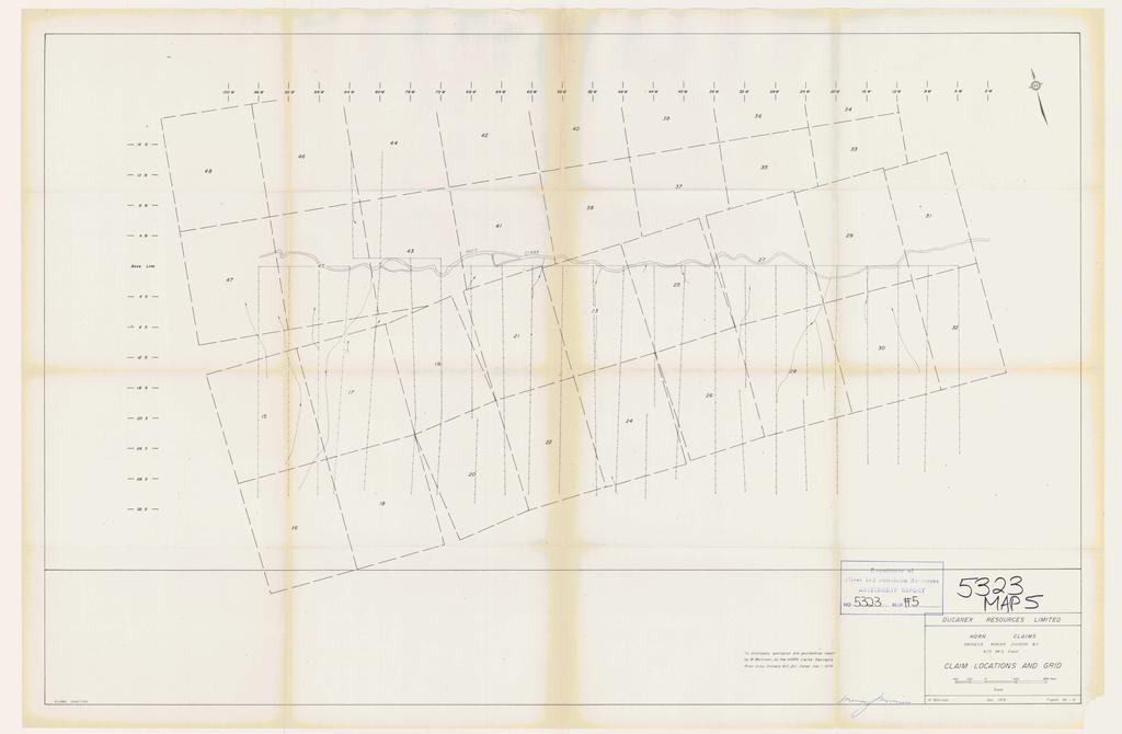
4 -1- INTRODUCTION T'he Horn property comprises a group of forty contiguous claims owned by Canadian Superior Exploration Limited. The group is located five miles nort'h of Motase Lake. In July and August, 1974, crews of Ducanex Resources Limited conducted exploration surveys on the property. This report is a compilation of data obtained during surveys combined with a discussion of results. SUMMARY Work done in 1973 by Canadian Superior Exploration Limited on the Horn claims indicated the occurrence of interesting molybdenum values in soils. Work this year, 1974, done by crews of Ducanex Resources Limited, was designed to track down the source of the molybdenum values. Geological and geochemical surveys were more detailed than those surveys of the previous year. The 1974 programme included trenching by 'hand, but deep overburden in the / prime areas of interest limited the value of this trenching. Therefore, drilling of the prime target zones is recommended for the 1975 season. 1.t I I
5
6
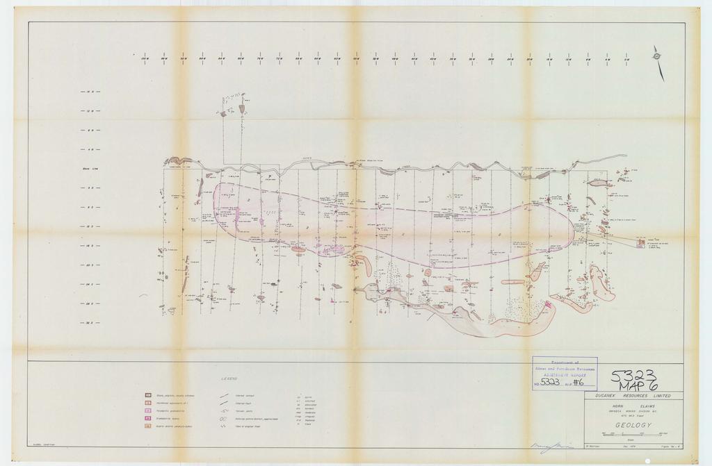
7
8
9 tributary of the Squingula River, 5 miles north of Motase Lake, approximately 100 miles north of Smithers, B.C. Elevations on the property range from 3,000 to 5,500 feet with differences of 1,500 feet over half a mile not unusual. Lower slopes on the property are characterized by stands of mature spruce and balsam separated by large patches of sitka alder, while intermediate slopes are covered with dense growths of mountain hemlock and stunted, gnarled balsam. Timber line is near 4,500 feet. Snow-free months are generally mid-june to mid- September for much of the property, but on the north-facing slope, where much of the 1974 work was done, snow persisted until late July at higher elevations. Access to the property is via fixed wing aircraft to Bear or Motase Lake and then by helicopter to the property, / During 1974 a wharf at a hunting cabin near.the north end of Motase Lake was used as a trapsfer point between fixed wing and helicopter transport. On the prop- erty only one helicopter pad, situated near Horn Creek, was used in This one helicopter pad is well situated.lp for next year's programme on the property.
10
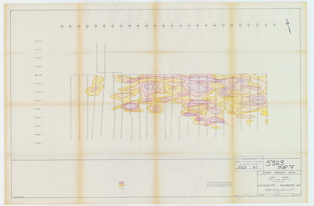
11 - 7 - Four shallow trenches were blas'ted and some sampling was carried out on local mineralized showings.
12
13
14 i (parallel with the strike of t'he intrusive), but appears to be post-intrusive, and shows little displacement. I Some faulting is coincident with the intrusive contact, but at many locations the granodiorite has an irregular contact with hornfels with embayments which are suggestive of an assimilation contact. 1 I ECONOMIC GEOLOGY 1 I 1 Features of the economic geology of the property, I I I 1, have been remarked upon under many of t'he other titles in t'his report. Here, I will try to lump the whole question of economic geology into one statement. I I! I Molybdenum appears to be the only element of economic interest on the property. It is widespread and I has several modes of occurrence, but the most interesting is the occurrence of molybdenite in hornfels. Near the intrusive contact t'he hornfels has been fractured and. then mended with quartz veinlets (2mm. ) Molybdenite has I / been introduced into the rock/with these quartz veinlets and it is found both wit'hin t'he quartz and disseminated into t'he rock adjacent to the veinlets. Molybdenite on the property is almost always associated with quartz veining, but what is necessary for an economic deposit is.t enough quartz veining per unit of rock to bring the
15 !-- _ molybdenum up to ore grade. A detailed prospecting of the claims has revealed that only the hornfels near
16
17
18 Ff?EQUENCY DlSTf?/BUTlON CURVE Molybdenum in PPM. Horn Claims Squingula River Arm Omineca M.D.
19
20
21
22
23 Sites for trenches were selected taking geology, geochemistry and overburden cover into account. In many locations trenches reached bedrock and revealed important information for mapping geology, although most molybdenum assays were low. Along the northern intrusive contact zone where information is most needed,.overburden is 10 to 20
24 APPENDIX Horn Claims, Pits and Trenches, 1974 A Page 1 of 3 Pit 5 x 5 x 2 to 5 ft. deep -5'- -1 No outcrop U Angular fibat = 95% hornfels Hfs is slightly sil, bleached, well fr'd and mended, with limonite 1-2" zones of fault breccia 5% PY, 2% secondary bio. with fault breccia No MoS2 seen. 6'- Pit 6 18" ptj - dlo dyke rubble x 6 x 2 to 6ft. deep 18" brecciated qtz-dio dyke lies between granodiorite intrusive and hor~fels 10% hornfels inclusions in dyke brecciated dyke has 5-10% py /Mod. fr'd hfs, I% py, I% qtz.vnlts trench 10x2~2' No MoS2 m well fr'd hfs, some faulting, 3% py, trench 25x2~3' deep / 1% qtz vns with 30% py L 16W 5 to ZS 1: 5s hfs float x: outcrop in creek cleaned off hfs 5% py, sampled faulted contact granodiorite dyke I% hfs py highly siiicifyed hfs, 5% qtz vnlts 2-3% py
25 p Page 2 of 3 0 L 16W 16s to 17s 16s # Overburden orly 6" dee I1 crumbly, weathered, rusty granodiori te Overburden mod. fr'd, rusty porp. granodiorite mainly fresh, I% qtz. VPS. PO py. fault gouge (his) no metaliic minerals no sample Sample #2934 chip sample to l6+85 S Mo S % Pit 5 x 5 x 2' deep. no outcrop avgular float:- 90% hfs with 1% py -5'- 1% qtz veinlets 10% white aplite No sample pit 50ft. north was sam~lied in 1973 Mo = 0.082% W s-6'-Pit 6 x 6 x I to 4ft deep no outcrop angular float:- 100% slightly sil. hfs, 5% py, 2% qtz vnlets tr MoS2 No sample pit 30ft.north was sampled ir, 1973 Mo =,0.026% Trench L36W 8+50S Pit 6x6x5ft. deep L36W 9+30 to 9+60S - 6 no outcrop 50% rounded float 50% angular float 40% well fr'd rusty granodiorite with 2% qtz. vns, I% py diss. 1 0% hfs with 2% qtz. vns. no outcrop I! Angular float:- 90% white sugary textured aplite + 9s 10% porp.granldte Both rock types well fr'd rusty 2% limonite 40x2~2' deep 5% qtz. vnlts, 10% py ir, qtz, tr MoS2 # 2928 # 2929 No sample Sample # chip sample 9+20 to 9+40S MoS2= 0.003% Tr. Au & Ag Sample #2929 ch~p sample to 9+60S MoSp = 0.005% Tr. Au + Ag
26 40+50 W 6s Pit 6x6~4 to 7 ft. deep + 6' - No outcrop Rounded float only: 50% hfs with tr. MoS2 50% porp. granodiorite 19% qtz. vns. with 5% py Page 3 of 3 No sample W 6+60S Pit 6 x 6 x 2 to 4ft. deep - 76'- No sample No outcrop Sub angular float: 70% rusty porp.grano 2% qtz.vnlts tr. to 1% py 0.01% MoS2 in one rock 30% hfs 3% qtz.vnlts, tr. to 1% py 0.02% MoS2 in one rock L6OW5+4OS. Piece of float (Ift. angular) hfs with 10% qtz. vnlts. Sample #2933 selected sample MoS2 = 0.55% tr Au + Ag Trench it? creek / ks Mod. fr'd hornfls, 5% qtz.vt?lts, 3% py Sample #2931 ch~p sample 6+40 to 6+60S MoS2 = 0.021% tr Au + Ag cur- Fresh, massive porp.granod\te L60 W 8+20 to 8+40S - 85 Fr'd faulted hfs, 5% qtz.vns tr.py Trench in creek / 5' wide fault zone Highly fractured foul ted grano- I d'te 5% qtz vns. tr py 1 Some chl. alteration Sample # ~ chip sample 8+20 to' 8+40S MoS2 = 0.038% L60W to!0+85s O Trench 15x3~2 to 7ft. deep No outcrop 95% angular porp.granod'te float 2" - 2pPt. mainly fresh, massive, tr. qtz vns. tr py No sample M. Morrison Dec/1974
27
28 -. L A APPENDIX C STATEMENT OF COSTS The following cost statement is for work
29
30 - 1- _-_. " p ppp APPENDIX D 0 STATEMENT OF QUALI FI CAT1 ONS I, Murray Morrison, of the City of Vancouver, in the Province of British Colmibia, do hereby state that: 1. I graduated from the University of British Colurnbia in 1969 with a B.Sc. degree in Geology. 2. I have been working in all phases of mining exploration in British Columbia for the past seven years. 3. During the past six years I 'have intermittently held responsible positions as a geologist with various mineral exploration companies in British Columbia. 8 4, I am presently employed as an exploration geologist with Ducanex Resources Limited. 1 L i 5, I carried out the geological mapping on the Horn property and I supervised +he geochemical sampling programme., l, & A ay Morrison / / Vancouver, B.C. December 1, 1974.P
31
32
33
Prospecting Report 'S Office i DB Property, B.C. -J Negro Creek Nelson Mining District NTS 82F.050. Operator: Kootenay Gold Inc.
 . '.' I"' i9 12 Prospecting Report 'S Office i DB Property, B.C. -J Negro Creek Nelson Mining District NTS 82F.050 Operator: Kootenay Gold Inc. Owner: Darlene Lavoie Work Performed Summer of 2007 Report
lat ' N Long ' W
 305 7 ec1;, REPORT ON THE JERY CLAIMS OF POLA RESOURCES LTD. NTS 93L/16 0 0 lat. 54 45' N Long. 126 22' W BABIXE LAKE AREA OMINECA MINING DIVISION, B.C. PAUL PLICKA CONSULTING GEOLOGIST DECEMBER 30, 1981
GEOLOGICAL MAPPING REPORT ON THE ASH MINERAL CLAIM OSOYOOS MINING DIVISION ASHNOLA RIVER MAP SHEET NTS M092,H019 MCBRIDE CREEK AREA, ASHNOLA RIVER,
 GEOLOGICAL MAPPING REPORT ON THE ASH MINERAL CLAIM OSOYOOS MINING DIVISION ASHNOLA RIVER MAP SHEET NTS M092,H019 LATITUDE 49 o O6, LONGITUDE 120 o 22 MCBRIDE CREEK AREA, ASHNOLA RIVER, KEREMEOS, B.C. CANADA
NEW HAZELTON, OMINECA M.D.,
 PROSPECTING REPORT JUDI 1 TO 6 MINERAL CLAIMS NEW HAZELTON, OMINECA M.D., B.C. MAP 93M/4E, LAT. SS014'N, LONG. 127'33'W OWNED BY: A. L'ORSA ANTHONY L'ORSA Smithers, B.C. 21 February, 1981 TABLE OF CONTENTS
PHYSICAL WORK REPORT. the BAY CLAIMS. Omineca Mining Division Smithers, British Columbia N.T.S. 93E 13E/W
 PHYSICAL WORK REPORT the BAY CLAIMS Omineca Mining Division Smithers, British Columbia a N.T.S. 93E 13E/W LATITUDE: 53 57 00 N I LONGITUDE: 127 45 OO W for Home Ventures Ltd. 1201-675 West Hastings Street
Reconnaissance. Of the. Denis mineral claims. Situated at Kilometer 844 of the Alaska Highway. Liard Mining Division. Northeastern British Columbia
 Reconnaissance Of the Denis mineral claims Situated at Kilometer 844 of the Alaska Highway Liard Mining Division Northeastern British Columbia N.T.S. 94M.075 Latitude 59 42 25 Longitude 127 13 12 Field
VANCOUVER, B.C. Tri 082F/ F/059
 GEOCHEMCAL REPORT t MAY L, 2006 Whbpper Mineral Claims Ailsa Lake Area Gold comm~ss16fl8f"s Offim on Mining Division VANCOUVER, B.C. Tri 082F/058 082F/059 3792 E 5486438 N Operator Kootenay Gold nc. Suite
For personal use only
 ASX RELEASE 13 July 2012 ASX Code: PMQ Encouraging Field Exploration Results: Mount Borium Gold Project Key Points Third phase of field exploration underway the Company has been highly active since the
for the Greenwood Mining Division, B.C. NTS 82E/7W Latitude 49' 27' W, Longitude 118' 5 Prepared by a= D. Dylan Watt, B.Sc.
 t. b LOGnO: 37~ -08 m. ACTIO#: for the AMP AMP 2 AMP 3 t AMP 4 CLAIMS Greenwood Mining Division, B.C. NTS 82E/7W Latitude 49' 27' W, Longitude 8' 5 %E c,w zc *& a w Prepared by a= -4c. D. Dylan Watt, B.Sc.
2013 GEOLOGICAL ASSESSMENT REPORT SHERIDAN HILL PROPERTY
 2013 GEOLOGICAL ASSESSMENT REPORT ON THE SHERIDAN HILL PROPERTY NEW WESTMINSTER MINING DIVISION BRITISH COLUMBIA NTS 092G07 49 16 31 NORTH LATITUDE, 122 39 48 WEST LONGITUDE PREPARED FOR Sheridan Hill
for the Greenwood Mining Division, B.C. NTS 82E/7W 29' W, Longitude 118' 53' N Prepared by D. Dylan Watt, B.Sc.
 for the FltE NO: u VOLT 1, VOLT 2, VOLT 3, & VOLT 4 CLAIMS Greenwood Mining Division, B.C. NTS 82E/7W Latitude 49' 29' W, Longitude 118' 53' N Prepared by D. Dylan Watt, B.Sc. #309-1996 Trutch Street Vancouver,
Elephant Mountain, Alaska Intrusive Related Gold Project July Option to Earn 100%
 Elephant Mountain, Alaska Intrusive Related Gold Project July 2018 Option to Earn 100% CORPORATE Corporate DISCLOSURE Disclosure The information contained herein, while obtained from sources which we believe
BRITISH NEWFOUNDLAND EXPLORATION LIMITED PROSPECTING REPORT JR AND MARK CLAIMS LIARD MINING DIVISION, B. C. By: Michael G.
 BRITISH NEWFOUNDLAND EXPLORATION LIMITED PROSPECTING REPORT JR AND MARK CLAIMS LIARD MINING DIVISION, B. C. By: Michael G. Willia 6- "t f I - -- ---- --.--. Department af I Brinex Report No. ~74546,- NTS
TABLE OF CONTENTS APPENDICES SUMMARY DRILL LOG STATEMENT OF QUALIFICATION STATEMENT OF EXPENDITURES LIST OF FIGURES
 ASSESSMENT WORK REPORT DIAMOND DRILLING PROGRAM AUGUST AND SEPTEMBER, 1980 ON CLAIMS Molly Tom 1-4 and 8 Omineca Mining Division NTS 93M/llU 55'35'N, 127"29'W by David A. Bending Owner: Operator: Texasgulf
BALFOUR MINING LTD. (N.P.L.) HAM GROUP 92-P-6, CLINTON M. D.8 B. C. Lat 51 17'N, GEOCHEMICAL REPORT. V. CUKOR, P. Eng.
 HAM GROUP 92-P-6, CLINTON M. D.8 B. C. Lat 51 17'N, GEOCHEMICAL REPORT. V. CUKOR, P. Eng.") 34q '7 BALFOUR MINING LTD. (N.P.L.) HAM GROUP 92-P-6, CLINTON M. D.8 B. C. Lat 51 17'N, Long 12lo14'W GEOCHEMICAL REPORT, V. CUKOR, P. Eng. January 31, 1972 TABLE OF CONTENTS 1. INTRODUCTION 2. PROPERTY,
34q '7 BALFOUR MINING LTD. (N.P.L.) HAM GROUP 92-P-6, CLINTON M. D.8 B. C. Lat 51 17'N, Long 12lo14'W GEOCHEMICAL REPORT, V. CUKOR, P. Eng. January 31, 1972 TABLE OF CONTENTS 1. INTRODUCTION 2. PROPERTY,
Drill locations for the 2015 program are highlighted in the geology map below.
 2015 Exploration Program The exploration program plan at KSM for 2015 was designed to improve the understanding of block cave targets and support engineering/environmental aspects of development scenarios.
RECONNAISSANCE GEOCHEMICAL SURVEY
 RECONNAISSANCE GEOCHEMICAL SURVEY LEGAL, RITA, LOUISE FR. (CHAPLEAU GROUP) REVERTED CROWN GRANTS CHAPLEAU CREEK AREAJ, SLOC& MINING DIVISION 82 F/11W Lat: 49'44" Long: 117"22'W MINERAL RESOURCES BRANCH
HOWE COPPER MINE PROJECT HIGH GRADE Cu-Ag with Au
 HOWE COPPER MINE PROJECT HIGH GRADE Cu-Ag with Au The Howe Copper Mine property is located approximately 55 kilometres northwest of Vancouver, BC. It is situated at 1431 metres elevation on the eastern
I MINERAL RESOURCES BRANCH N 0. 6/52. Report By: W. J. WILKINSON, B.Sc. January, Mineral Hill A, Record No. 397 (8) ASSESSMTNT REPORT
 ASSESSMTNT REPORT") 6 152 IlEPORT ON PERCUSSION DRILLING ON MINERAL CLAIMS: Mineral Hill, Record No. 206 (1) Mineral Hill A, Record No. 397 (8) Mineral Hill B, Record No. 398 (8) Located Near Houston, B. C.; 93L/10E 54O 31'
6 152 IlEPORT ON PERCUSSION DRILLING ON MINERAL CLAIMS: Mineral Hill, Record No. 206 (1) Mineral Hill A, Record No. 397 (8) Mineral Hill B, Record No. 398 (8) Located Near Houston, B. C.; 93L/10E 54O 31'
cpw 6. E. Spencer Engineering Ltd. HANNA 9 M. C. 104 REP 0 RT DIAMOND DRILLING PROGRAMME LIARD MINING DISTRICT, K.T.S. FOR TAURUS RESOURCES LTD.
 6. E. Spencer Engineering Ltd. LlJ REP 0 RT ON DAMOND DRLLNG PROGRAMME cpw HANNA 9 M. C. LARD MNNG DSTRCT, K.T.S. 104 P@g FOR TAURUS RESOURCES LTD. BY B. E. SPENCER, P. ENG. B. E. SPENCER ENGNEERNG LTD.
ASSESSMENT REPORT. Geochemical and Geological Surveys. on the. Gooch#1-4. Mineral Claims. Omenica Mining District NTS 93L/7W
 f- GEOLOGICAL BRANCH ASSESSMENT REPORT ASSESSMENT REPORT Geochemical and Geological Surveys on the Gooch#1-4 Mineral Claims Omenica Mining District NTS 93L/7W LAT: 54O25'W LONG: 126O26'W Operator: SMD
TOPOGRAPHICAL SURVEY REPORT ON THE GREENDROP PROPERTY NEAR CHILLIWACK, B.C. 92-H-3/W
 TOPOGRAPHICAL SURVEY REPORT ON THE GREENDROP PROPERTY NEW WESTMINSTER M.D. NEAR CHILLIWACK, B.C. 92-H-3/W Location: The central pap of the claims is located at coordinates 49 08'N, latitude by 121 26'W,
PROSPECTING REPORT THE WALLACE CLAIM OMENICA MINING DIVISION. 54" x6" 3.d d. for. Reako Exlorat ions Ltd. Wallace Rev. C.G.
 PROSPECTING REPORT ON THE WALLACE CLAIM OMENICA MINING DIVISION 54"44 14 1x6" 3.d d by David A. Howard P.Eng. for Reako Exlorat ions Ltd. Claim Locat ion Wallace Rev. C.G. #1560 Dome Mountain Area 9 3
GEOLOGICAL BRANCH ASSESSMENT REPORT 12. FItE NO: ACTION: THE GOLDEN MINING DIVISION, GOLDEN, Including THE NTS MAP; M82K/15W
 ACTION: FItE NO: Including 1990 GEO-CHEM SURVEY RESULTS -- THE AVD CLAIMS - THE GOLDEN MINING DIVISION, GOLDEN, B.C. NTS MAP; M82K/15W Lat. 50 deg. 55 Min. Long 116 deg. 55 min. For GEOLOGICAL BRANCH ASSESSMENT
Mineral Titles Online
 https://www.mtonline.gov.bc.ca/mto/jsp/sow_m_c/soweventconfirmation.jsp?ca.bc.gov.e... Page 1 of 2 1/20/2010 Mineral Titles Online Mineral Claim Exploration and Development Work/Expiry Date Change Recorder:
Queensland Mining Corporation Limited
 Queensland Mining Corporation Limited ABN 61 109 962 469 ASX Release 29 th July 2011 Drilling Commenced at Duck Creek Copper-Gold Project, Cloncurry, North-west Queensland Highlights RC drilling has commenced
UNION MINIERE EXPLORATIONS AND MINING CORPORATION LIMITED ASSESSMENT REPORT ON FITINAT MINERAL CLAIM. Alberni Mining Division Record No.
 M F )( UNION MINIERE EXPLORATIONS AND MINING CORPORATION LIMITED Suite 200, 4299 Canada Way, Burnaby, B.C. V5G 1 H4 Telephone (604) 437-9491 ASSESSMENT REPORT ON GEOCHEMICAL SOIL SURVEYS AND ROCKSAMPLING
SECOND and THIRD YEAR ASSESSMENT REPORT PROSPECTING LICENCE M, ROCK CUT PROPERTY, NTS 1N/12, NEWFOUNDLAND. ROY FRENCH (licence holder )
") SECOND and THIRD YEAR ASSESSMENT REPORT Of PROSPECTING On LICENCE 013704M, ROCK CUT PROPERTY, NTS 1N/12, NEWFOUNDLAND. By ROY FRENCH (licence holder ) Work Conducted: Sept. 17, 2008 Nov. 03, 2009 Total
SECOND and THIRD YEAR ASSESSMENT REPORT Of PROSPECTING On LICENCE 013704M, ROCK CUT PROPERTY, NTS 1N/12, NEWFOUNDLAND. By ROY FRENCH (licence holder ) Work Conducted: Sept. 17, 2008 Nov. 03, 2009 Total
PROJECT DETAILS August 2014
 PROJECT DETAILS August 2014 Executive Summary InterGroup Mining Pty Ltd has a major gold exploration project located in North Queensland, Australia, in an underexplored high gold bearing district, west
DISCOVERY OF MINERALISED PORPHYRY & MAGNETITE-COPPER-GOLD AT KAMARANGAN
 MEDUSA MINING LIMITED ABN: 60 099 377 849 Unit 7, 11 Preston Street Como WA 6152 PO Box 860 Canning Bridge WA 6153 Telephone: +618-9367 0601 Facsimile: +618-9367 0602 Email: admin@medusamining.com.au Internet:
Prospectors Making NEW Discoveries
 Prospectors Making NEW Discoveries Hans Smit Minerals North 2012 Burns Lake, British Columbia May 2012 BC Needs New Discoveries BC mines and most advanced mineral projects were found decades ago To ensure
 >
> Altan Nar. Gold & Base Metal Discovery (Tsenkher Nomin Property) October 12 th, 2011
 October 12 th, 2011") Altan Nar Gold & Base Metal Discovery (Tsenkher Nomin Property) October 12 th, 2011 1 FORWARD-LOOKING STATEMENTS Certain information regarding Erdene ("the Company") contained herein may constitute forward-looking
Altan Nar Gold & Base Metal Discovery (Tsenkher Nomin Property) October 12 th, 2011 1 FORWARD-LOOKING STATEMENTS Certain information regarding Erdene ("the Company") contained herein may constitute forward-looking
BLURTON CREEK NICKEL PROPERTY. (Minfile # 082LNW-039)
") 5489153 BLURTON CREEK NICKEL PROPERTY (Minfile # 082LNW-039) Mara Lake Area / Salmon Arm B.C NTS - 82L-11 (UTM 83/Z10, 357690E, 5614220N) Prepared by: Jim Cuttle, B.Sc., P.Geo. 86 Cloudburst Road Whistler,
5489153 BLURTON CREEK NICKEL PROPERTY (Minfile # 082LNW-039) Mara Lake Area / Salmon Arm B.C NTS - 82L-11 (UTM 83/Z10, 357690E, 5614220N) Prepared by: Jim Cuttle, B.Sc., P.Geo. 86 Cloudburst Road Whistler,
ASSESSMENT REPORT PROSPECTING PROGRAM ION/DIRTY JACK PROPERTY NELSON MINING DIVISION N.T.S. MAP SHEET 82F.023 UTM COORDINATES N E
 ASSESSMENT REPORT PROSPECTING PROGRAM ION/DIRTY JACK PROPERTY NELSON MINING DIVISION N.T.S. MAP SHEET 82F.023 UTM COORDINATES 5454800N - 0455235E Work Performed Summer 2007 OWNER >* ' Tom Kennedy >8 404-22
HIGH GRADE GOLD-BEARING QUARTZ VEIN DISCOVERED AT MIAREE, KARRATHA AREA WESTERN AUSTRALIA
 17 November 2010 Company Announcements Office Australian Stock Exchange Limited 20 Bridge Street SYDNEY NSW 2000 HIGH GRADE GOLD-BEARING QUARTZ VEIN DISCOVERED AT MIAREE, KARRATHA AREA WESTERN AUSTRALIA
Canadian National Railways tracks from the foot bridge across the. Thompson River from the Trans Canada Highway. A pick-up truck was used
 Canadian National Railways tracks from the foot bridge across the Thompson River from the Trans Canada Highway. A pick-up truck was used on the highway side and a h-wheel drive Jeep was transported by
SQUARE POST PROJECT CHARTERS TOWERS NORTH QUEENSLAND AUSTRALIA
 SQUARE POST PROJECT CHARTERS TOWERS NORTH QUEENSLAND AUSTRALIA Square Post - Summary PROJECT DETAILS - SQUARE POST The Square Post exploration permit (EPM 18510) contains two styles of mineralisation:
7 miles West of Kamloops, B.C.
 MINERAL RESOURCES BRANCH ASSEWAENT RiPORT of hole # 78-11 NO. drilled on the ZZ # 18 Claim of China Commercial Corporation Ltd situated 7 miles West of Kamloops, B.C. in the Kamloops Mining Division D.R.
Negro Creek Fort Steele Minina Division. CRAIG KENNEDY Prospector
 AUG and SKAY Claims Negro Creek Fort Steele Minina Division NTS 82 F8/E Latitude 49O28 N Lonqi tude 116 Ol W BY CRAIG KENNEDY Prospector September 5, 1996 TABLE OF CONTENTS Page 1.00 INTRODUCTION 1.10
Serengeti Resources Inc GEOCHEMICAL REPORT ON THE SHADOW PROPERTY a.
 Serengeti Resources Inc. 2004 GEOCHEMICAL REPORT ON THE SHADOW PROPERTY a. Located in the Johanson Lake Area Omenica Mining Division NTS 94D/9 6 degrees and 32 minutes North Latitude 126 degrees and 2
on the SALAL CREEK MOLYBDENUM PROPERTY, SALAL CREEK, B.C. LILLOOET MINING DIVISION, BRITISH COLUMBIA
 on the J PLUG 9-12, PLUG 19-24, BAT 10-14, BAT 15 Fr., BAT 16 Fr. MINERAL CLAIMS, SALAL CREEK MOLYBDENUM PROPERTY, SALAL CREEK, B.C. LILLOOET MINING DIVISION, BRITISH COLUMBIA N.T.S. 92 J 14 LATITUDE 50
Mirasol Outlines 1.4 km long Geophysical Anomaly at the Resolution Trend of the Nico Ag-Au Project, Santa Cruz, Argentina
 NEWS RELEASE Mirasol Outlines 1.4 km long Geophysical Anomaly at the Resolution Trend of the Nico Ag-Au Project, Santa Cruz, Argentina VANCOUVER, BC July 5, 2018 Mirasol Resources Ltd. (TSXV: MRZ), (OTCPK:
Metallic Mineral Exploration in Minnesota: Typical Exploration Activities. Division of Lands and Minerals Minnesota Department of Natural Resources
 Metallic Mineral Exploration in Minnesota: Typical Exploration Activities Division of Lands and Minerals Minnesota Department of Natural Resources Metallic minerals can only be mined economically where
Nortec provides Tomboko Exploration Results Update
 Nortec provides Tomboko Exploration Results Update Vancouver, BC / TNW ccesswire / June 11, 2018 (the Company or Nortec ) (TSXV: NVT) announces completion of diamond core drilling and is now running a
GEOCHEMICAL REPORT THE 82M/12 FH GROUP BIRCH ISLAND, B.C. S1 119O NOW. ROYAL CANADIAN VENTUR 3S LTD. By: Vollo, P. Eng. N.B. Pay 28th, 1969.
 c GEOCHEMICAL REPORT ON THE 82M/12 FH GROUP AT BIRCH ISLAND, BC S1 119O NOW BY ROYAL CANADIAN VENTUR 3S LTD NB By: Vollo, P Eng Pay 28th, 1969 Approximately 700 samples were collected over 14 miles of
12 tons of high-grade ore was mined from the No. 1 vein with an average grade of 13 g/t gold, 3,250 g/t silver and 23.3% lead.
 DUNWELL MINE GROUP The Dunwell Mine Group (Dunwell, Dunwell East, Bear River/MM and Silvershot properties), which includes the historic, past-producing Dunwell mine, is located 8 km northeast of Stewart
GEOCMCAL SURVEY LOOP PROPERTY NCRAIIDA EXPLORATION COMPANY, LIMITED OMINECA MINING DIVISION JULY 5, 1971 TO JULY 30, 1971
 GEOCMCAL SURVEY LOOP PROPERTY NCRAIIDA EXPLORATION COMPANY, LIMITED OMINECA MINING DIVISION JULY 5, 1971 TO JULY 30, 1971 TABLE OF CONTENTS INTRODUCTION 2 li Fig. A (Incation Map) GENERAL GEOLOGY GRID
ASSESSMENT REPORT MAGNETOMETER SURVEY GOLDEN ROD, GOLDEN ROD #2. Long.: General Delivery, Vananda, B. C.
 ASSESSMENT REPORT MAGNETOMETER SURVEY GOLDEN ROD, GOLDEN ROD #2 t=/ NTS 92~110w Lat.: Long.: 49O 44' N 124O 34' W Owner: E. Johanson General Delivery, Vananda, B. C. Operator: Rhyolite Resources I nc.
JV Project Portfolio Executive Summary: Bruce Smith
 JV Project Portfolio Executive Summary: Bruce Smith September 5, 2012 Disclaimer Forward-Looking Statements This presentation contains forward-looking statements, including but not limited to comments
GEOLOGY AND LITHOGEOCHEMISTRY OF THE CHILKO-TASEKO LAKES AREA* BY G.
 B Ministry of Energy, Mines and Petroleum Resources GEOLOGICAL BRANCH MINERAL RESOURCES DIVISION NOTES TO ACCOMPANY OPEN FILE - GEOLOGY AND LITHOGEOCHEMISTRY OF THE CHILKO-TASEKO LAKES AREA* BY G. P. McLAREN
CAMP MINERAL CLAIM,, 1
 CAMP MNERAL CLAM,, 1 . ~~, ~~...* 1.... -, --, -. Province of British Columbia, ' ' ', P&&y:,i. ~,,,.,.,,', :,,, ' i, ;. Ministry of ' Energy, Mines and ASSESSMENT REPORT,,!" Petroleum Resources TTLE PAGE
Narrow High-Grade Gold and Long Low-Grade Porphyry Gold and Copper-Gold Intercepts at Bulago
 CONTACTS PHONE EMAIL PO Box 52 +61 (08) 9295 0388 info@frontierresources.com.au West Perth FAX WEBSITE WA 6872 Australia +61 (08) 9295 3480 www.frontierresources.com.au ASX Limited Company Announcements
GRISWOLD CREEK, B.C. 6 " GEOCHJ3lICAL REPORT
 GRISWOLD CREEK, B.C. 6 " GEOCHJ3lICAL REPORT AUTROR: W. Meyer, BSc. ENDORSED El!: John De Leen, BASc.* NASc., E.M., P. Eng. No. 3675 Vancouver, B.C. January 22nd, 1965. -I- During the period of July 27th
Summary of Rover Metals Geologic Mapping Program at the Up Town Gold Project, Northwest Territories
 October 13, 2017 Summary of Rover Metals Geologic Mapping Program at the Up Town Gold Project, Northwest Territories Vancouver, British Columbia, Canada - Rover Metals Corp., Rover, is pleased to provide
For personal use only
 10 July 2012 Encouraging New Gold Results from Gunung Rosa Drilling Highlights Assay results from three drill holes at depth under the Cap Palu section confirm significantly wider intercepts of gold-copper-base
SOUTHWEST & NORTHWEST EXPLORATION PROJECTS BINGHAM CANYON MINING DISTRICT
 SOUTHWEST & NORTHWEST EXPLORATION PROJECTS BINGHAM CANYON MINING DISTRICT SALT LAKE AND TOOELE COUNTIES, UTAH SUMMARY FRIDAY, MARCH 20, 2009 1 Tooele County Salt Lake County GOOGLE EARTH September, 2006
PROSPECTORS ASSISTANCE PROGRAM MINISTRY OF ENERGY AND MINES
 BRITISH COLUMBIA PROSPECTORS ASSISTANCE PROGRAM MINISTRY OF ENERGY AND MINES GEOLOGICAL SURVEY BRANCH PROGRAM YEAR: 1999/2000 REPORT #: PAP 99-l 6 NAME: KIM ANSCHETZ PROSPECTORS TlEPORT on the 99 LOUIS
vox 1wo LOG NO: SEP 1 019% RD. &CTlON. JG-1, PILOT GOLD, PILOT GOLD 1 h 2. AND GOLD WING 1 TO 6 CLAIMS for HAROLD ADAMS Box 1329 Princeton, B.C.
 LOG NO: SEP 1 019% RD. &CTlON. JG-1, PLOT GOLD, PLOT GOLD 1 h 2. AND GOLD WNG 1 TO 6 CLAMS r Weyrnan Creek Area Kamloops Mining Division 82L-5W (50O22' N. Lat., 119O59' W. Long.) for HAROLD ADAMS Box 1329
1 The Prospectus can be obtained on the Company s website at or on SEDAR at
 Company Announces the Commencement of a Diamond Drilling Program at Tourokhoto the First of its 39 Drill Targets as part of a US$19M Exploration Program Toronto, December 16, 2010 Teranga Gold Corporation
compietea since tnat date, and wnicn comprisea btage I ot tne recommended
 compietea since tnat date, and wnicn comprisea btage I ot tne recommended four-stage program. GEOLOGY & MINERALIZATION The property situate6 on the southeast slope of Nickel Plate Mtn., and within the
SPL 1452 NAMOLI & WAINIVAU GOLD AND COPPER PROSPECTS
 SPL 1452 NAMOLI & WAINIVAU GOLD AND COPPER PROSPECTS (Multiple Namosi-like Exploration Targets) SPL1452 being contiguous with the Namosi SPL1420 owned by the Newcrest Joint Venture and with the same type
MINCOR /GOLDEN RIM FIJI JOINT VENTURE SIGNIFICANT NEW EXPLORATION RESULTS
 1 November 2007 MINCOR /GOLDEN RIM FIJI JOINT VENTURE SIGNIFICANT NEW EXPLORATION RESULTS Highlights Very high gold-in-soil sample results up to 17.3 g/t gold have been received from the Banana Creek Prospect.
LINGIG PORPHYRY COPPER DISCOVERY
 MEDUSA MINING LIMITED ABN: 60 099 377 849 Unit 7, 11 Preston Street Como WA 6152 PO Box 860 Canning Bridge WA 6153 Telephone: 618-9367 0601 Facsimile: 618-9367 0602 Email: admin@medusamining.com.au Internet:
Encouraging drill results from Paroo Range
 17 July 2012 The Manager ASX Company Announcements Office PO Box H224, Australia Square SYDNEY NSW 2001 Encouraging drill results from Paroo Range Highlights Significant uranium mineralisation at the 100%
News Release No GOLD AND COPPER MINERALIZATION DISCOVERED DURING PHASE 2 EXPLORATION AT THE MCBRIDE PROPERTY
 November 19, 2018 TSX Venture Exchange Listed Frankfurt Exchange Listed News Release No. 303-2018 GOLD AND COPPER MINERALIZATION DISCOVERED DURING PHASE 2 EXPLORATION AT THE MCBRIDE PROPERTY Vancouver,
Gold Mountain Group Gold Mtn. A, B, C & D Mineral Claims Record Nos. 697, 698, 699 & 700. Island Mountain Cariboo Mining Division British Columbia
 GOLD POINT RESOURCES LTD. Geophysical Survey Gold Mountain Group Gold Mtn. A, B, C & D Mineral Claims Record Nos. 697, 698, 699 & 700 Island Mountain Cariboo Mining Division British Columbia Vancouver,
ASX Announcement. 28 January Drill results indicate large Porphyry Copper Gold System at Peenam
 ASX Announcement 28 January 2010 Drill results indicate large Porphyry Copper Gold System at Peenam Highlights: 270 metres of visible copper (gold) mineralisation in first diamond core hole at Peenam Prospect
ANTLER GOLD EXPLORATION UPDATE, WILDING LAKE GOLD PROJECT, NEWFOUNDLAND
 ANTLER GOLD EXPLORATION UPDATE, WILDING LAKE GOLD PROJECT, NEWFOUNDLAND HALIFAX, NOVA SCOTIA (CNW May 10, 2018) Antler Gold Inc. ( Antler ) (TSX-V:ANTL) is pleased to provide an update on its upcoming
n3a 92 C- /.I 4 tr November 6, 1979 J. F. MclNTYRE, P.ENG. CONSU LTlNG MINING ENGl NEER Map #92C-16 TRANS PACIFIC VENTURES LTD.
 TELEPHONE : 5 9 6-1331 J. F. MclNTYRE, P.ENG. CONSU LTlNG MINING ENGl NEER 6466 CAGELDU CRESCENT DELTA, B.C. CANADA TRANS PACIFIC VENTURES LTD. c i. SAMPLING AND GEOPHYSICAL REPORT CAP CLAIM, VICTORIA
Structural Analysis Using Hillshade Imagery. on the. LLC Property
 Structural Analysis Using Hillshade Imagery on the LLC Property Liard Mining Division NTS 104F/16W Latitude: 57 53' 47'' N Longitude: 132 03' 06'' W Owner Garry John Payie 3714 Raymond Street South, Victoria,
LUCKY BEN MINE PROJECT SEPTEMBER 2018 UPDATE
 LUCKY BEN MINE PROJECT SEPTEMBER 2018 UPDATE During the first week of July 2018 work was completed by our Geologist, Richard Morris, and support personnel to stake the Lucky Ben vein structure at surface
27 metres Grading 66.8 g/t Gold and
 ADDRESS PHONE EMAIL PO Box 35 +61 (8) 9295 0388 info@frontierresources.com.au North Perth FAX WEBSITE WA 6906 Australia +61 (8) 9295 3480 www.frontierresources.com.au ASX Limited Company Announcements
Sombrero Butte Copper Project Arizona, USA
 Sombrero Butte Copper Project Arizona, USA January 2017 Sombrero Butte Project Location COPPER CREEK DEPOSIT (7.75 Billion Lbs Cu) SAN MANUEL KALAMAZOO MINE (BHP) (10.4 Billion Lbs Cu) SOMBRERO BUTTE EXPLORATION
Prospect Resources Signs Mining Agreement over Bucks Reef Gold Mine.
 Prospect Resources Signs Mining Agreement over Bucks Reef Gold Mine. HIGHLIGHTS Prospect Resources has secured the mining rights to the Bucks Reef Gold Mine, which lies some 600m west of its Prestwood
 ..m,"f.k*"--v- A tot,al of 18 line miles of magnetometer surveying was completed on the "B" and "J" claim groups during August of 197. Approximately two-thirds of the area covered by the survey is glaciated,
Update on Columbus Gold's Eastside Gold Discovery in Nevada
 Columbus Gold Corporation 1090 Hamilton Street Vancouver, B.C. V6B 2R9 Phone: (604) 634-0970 Fax: (604) 634-0971 Toll Free: 1 888 818-1364 info@columbusgroup.com www.columbusgroup.com NEWS RELEASE Update
FIRST YEAR ASSESSMENT REPORT PROSPECTING LICENCE 16512M MARYSTOWN AREA, BURIN PENINSULA NTS 1M/3
 FIRST YEAR ASSESSMENT REPORT OF PROSPECTING ON LICENCE 16512M MARYSTOWN AREA, BURIN PENINSULA NTS 1M/3 BY NATHANIEL NOEL MSc. FOR E. MICHELE NOEL MINERAL LICENCES: 16512 M WORK CONDUCTED: MID-SEPTEMBER
Great Atlantic Rock Samples Return up to 5.8 oz. / ton Gold Golden Promise Property in Central Newfoundland
 Great Atlantic Rock Samples Return up to 5.8 oz. / ton Gold Golden Promise Property in Central Newfoundland FOCUSED ON EXPLORING ATLANTIC CANADA (TSXV : GR) (FRA: PH01) VANCOUVER, British Columbia August
41,a* h0.iiii*bll*i2l,i DEADWOOD CREEK. for. James R. on the BOMBINI GROUP OF CLAIMS. GREENWOOD, British Columbia. Lat. 49'07' Long. 118'43 f.
 GEOLOGCAL REPORT on the BOMBN GROUP OF CLAMS DEADWOOD CREEK GREENWOOD, British Columbia Lat. 49'07' Long. 118'43 f in the GREENWOOD MNNG DVSON for FURY EXPLORATONS LTD. (N. P. L. ) Vancouver, B. C. December
ASX / MEDIA RELEASE 6 MAY MILE SILVER-LEAD-ZINC DISCOVERY; HIGH GRADE SILVER-GOLD IN ROCK CHIPS AT RUBY SILVER
 ASX / MEDIA RELEASE 6 MAY 2011 4-MILE SILVER-LEAD-ZINC DISCOVERY; HIGH GRADE SILVER-GOLD IN ROCK CHIPS AT RUBY SILVER Highlights: Silver-lead-zinc discovery at 4-Mile; mineralisation intersected in all
ASSESSMENT REPORT GEOLOGICAL BRANCH. 50' 23 'North. GEOLOGICAL and GEOCHEMICAL SURVEYS ON THE. PUTNAM PROPERTY (Putnam Mineral Claim)
") GEOLOGICAL and GEOCHEMICAL SURVEYS ON THE PUTNAM PROPERTY (Putnam Mineral Claim) VERNON MINING DIVISION, B.C. GEOLOGICAL BRANCH ASSESSMENT REPORT NTS : Latitude: 82L17W 50' 23 'North LOCATION, ACCESS,
GEOLOGICAL and GEOCHEMICAL SURVEYS ON THE PUTNAM PROPERTY (Putnam Mineral Claim) VERNON MINING DIVISION, B.C. GEOLOGICAL BRANCH ASSESSMENT REPORT NTS : Latitude: 82L17W 50' 23 'North LOCATION, ACCESS,
The Cobalt Rainbow. Airborne geophysical maps show that a north trending aeromagnetic high suggests further undiscovered mineralisation.
 The Cobalt Rainbow The property is located on Greenstone Creek, approximately 4.8 kilometres south west of the creek mouth. The property is located about 24 km due west of Campbell River, in the east-central
5 & GEOCHEMICAL REPORT. on the JULIET CLAIM. Coquihalla Area Nicola Mining Division. GRANT F. CROOKER, B.Sc., Geologist F.G.A.C.
 GEOCHEMICAL REPORT 5 & on the JULIET CLAIM Coquihalla Area Nicola Mining Division 92H-llE (49O 44 N. Lat., 121O 04 W. Long.) GRANT F. CROOKER, B.Sc., Geologist F.G.A.C.. (Owner and Operator) August 1987
Drilling Program Commences on Iron Oxide Copper Gold Targets
 3 June 2008 Manager Company Announcements Company Announcements Office Australian Stock Exchange Limited Level 10, 20 Bond Street SYDNEY NSW 2000 ABN 42 082 593 235 Electronic delivery No of pages: 6 Drilling
1 FILMED 1. FILE NO:!..rsrru -* -. GRAND TWO CLAIM
 FILE NO:!..rsrru -* -. GRAND TWO CLAIM REPORT ON 1993 ASSESSMENT WORK GRAND TWO CLAIM REC. NO. 301849 NELSON MINING DIVISION NTS MAP SHEET 82F6/W 49 25'51" NORTH 117 18'08" WEST 1 FILMED 1 AUTHOR: R. Jordan,
RE~ORT ON. J.F.V. MILLAR, P. Eng. GEOCHEMICAL SURVEY TIMBASKET AND MOGUL MINERAL CLAIMS. Kinbasket Lake, B. C. 51 degrees 118 degrees N.E.
 RE~ORT ON GEOCHEMICAL SURVEY TIMBASKET AND MOGUL MINERAL CLAIMS Kinbasket Lake, B. C. 51 degrees 118 degrees N.E. J.F.V. MILLAR, P. Eng. Lease held by J.F.V. MILLAR Work done Sept. 22 - Oct. 3, 1967. REPORT
COPPERSTONE RESOURCES AB INTERCEPTS ZONE OF CHALCOPYRITE-ARSENOPYRITE- BORNITE MINERALIZATION AT SVARTLIDEN IN FIRST DEEP DRILLHOLE FROM 720m-810m
 COPPERSTONE RESOURCES AB INTERCEPTS ZONE OF CHALCOPYRITE-ARSENOPYRITE- BORNITE MINERALIZATION AT SVARTLIDEN IN FIRST DEEP DRILLHOLE FROM 720m-810m In mid-january 2017 Copperstone Resource published a geological
Timberline Resources Agrees to Acquire Battle Mountain Gold-Copper Property Interests
 Timberline Resources Agrees to Acquire Battle Mountain Gold-Copper Property Interests Elder Creek and Paiute Gold-Copper Projects Battle Mountain District, Nevada April 2018 Cautionary Statements Forward
Fox 2-Record No. 2524
 F HELICOPTER E.M. AND MAGNETOMETER SURVEY OVER THE FOX CLAIMS, OMINECA MINING DISTRICT BRITISH COLUMBIA ON BEHALF OF OWNER MR. MIKE BOYLE Claims: Fox l-record No. 2523 Fox 2-Record No. 2524 Location 126'
3 I1 I I Ill 111 II! II 111 II Ill I IlE I I P I
 -7 3 1 1 11111111111111111111111111111111 ll 111! 111 111 111 111 111111111111111 ll 1111111 1 11111111111111 le P GEOCHEMCAL SURVEY OF THE KE AND D'ARCY CLAM GROUPS.. Similkameen Mining Division, B.C.
For personal use only
 L4 66 Kings Park Road West Perth WA 6005 P: +61 8 6141 3585 F: +61 8 6141 3599 E: info@drakeresources.com.au ASX Announcement 16 th September 2014 Seimana Gold Project Technical Update and Next Steps Geophysical
DIANOND DRILLING REPORT. NICOLA MINING DIVISION, B.C. Lat 'N, Long. 12O03O'W N.T.S. Map 921/1 W82E. for
 W DIANOND DRILLING REPORT MM #1, MM #2, MM #3, INEZ #1, INEZ #2, AND CROWN GRANTED CLAIMS NICOLA MINING DIVISION, B.C. Lat. 50 10'N, Long. 12O03O'W N.T.S. Map 921/1 W82E for FLAIR RESOURCES LTD. 1417-409
CRATER MOUNTAIN MAJOR MULTIPLE MINERALISATION EVENTS POTENTIAL ASSOCIATED WITH PORPHYRY SYSTEM NOW IDENTIFIED
 Registered Office and Postal Address Gold Anomaly Limited ABN 75 067 519 779 Level 4, 15-17 Young St Sydney, NSW, 2000 Australia Ph (02) 9241 4224 Fax (02) 9252 2335 30 th December 2011 Company Announcements
PRECIOUS METALS. owner. JMT Services Corp. GEOCHPlICAL SAMPLING CHELASLIE WCE, NORTH CENTRAL, B.C. OMINECA MINING DIVISION NTS 93F/5E & 6W
 PRECIOUS METALS REPORT ON 1980 RECONNAISSANCE GEOCHPlICAL SAMPLING CHELASLIE WCE, NORTH CENTRAL, B.C. OMINECA MINING DIVISION NTS 93F/5E & 6W LATITUDE 53O28 N LONGITUDE 125O31 W DATES Qp WORK: JULY 10
GEOLOGIC SETTING OF THE WADSWORTH VEIN: AN INTRUSIVE-RELATED GOLD DISCOVERY NEAR TERRACE, B.C.
 WADSWORTH VEIN By Paul J. Wojdak, Wayne Bulmer and Daryl J. Hanson LOCATION: Lat. 54 57 33 N Long. 128 50 09 W (103I/15W) CLAIMS: ACCESS: SKEENA MINING DIVISION. The property is located in the Cedar River
Mines and,3efro!sgrn Resources
 on the JO ANN MINERAL C LAIMS 35 Miles Northwest of Germansen Landing, B.C. Omineca Mining Division British Columbia MineralClaimMap 93N/13E, 14W Latitude: 55O 57' Longitude: 125O 28' by Douglas Stelling,
SUMBA EXPLORATION UPDATE
 ASX RELEASE Tuesday, 23 November 2010 SUMBA EXPLORATION UPDATE Hillgrove Resources Limited (ASX:HGO) today announces a planned airborne geophysical survey, Pelitalira prospect progress and final results
The survey covered claims, in part or in full, DUCKLING 3, 4, 5, 4 fraction, and 5 fraction.
 514 687-6671 XXX- 602 West Hastin~a StroeP, Vata;sn@ouver, BritlsA fhlum~b~a, Garaadsa B81apphgtaa DISCUSS ION OF MAGNETOMETER SURVEY ON DUCKLING CLAIMS FOR DONNA MINES LTD. (N0P.L.) Submitted to: DONNA
M.U.T. CLAIMS GROUP C, SALMO AREA, B.C. WORK PERFORMED DURING MARCH, APRIL,. AUGUST, SEPTEMBER, NOVEMBER AND DECEMBER, 1977.
 REPORT ON GEOLOGICAL, PHYSICAL AND DRILLING WORK, M.U.T. CLAIMS GROUP C, SALMO AREA, B.C. WORK PERFORMED DURING MARCH, APRIL,. AUGUST, SEPTEMBER, NOVEMBER AND DECEMBER, 1977. V.M. RAMALINGASWAMY MARCH