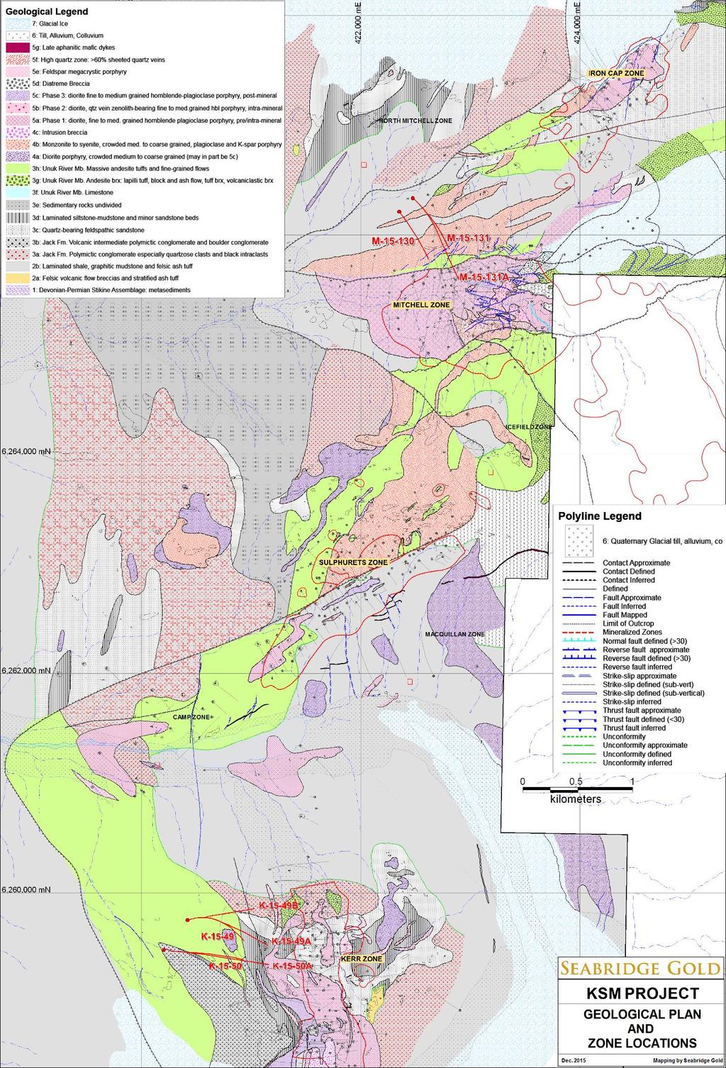
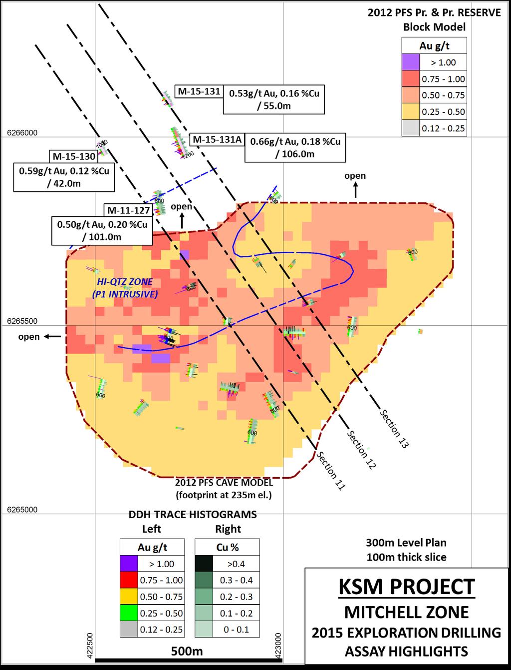
Drill locations for the 2015 program are highlighted in the geology map below.
|
|
|
- Rosemary Sims
- 5 years ago
- Views:
Transcription
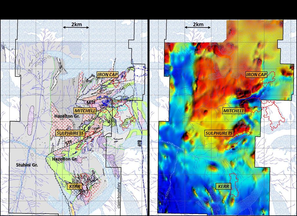
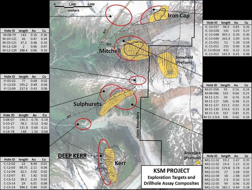
1 2015 Exploration Program The exploration program plan at KSM for 2015 was designed to improve the understanding of block cave targets and support engineering/environmental aspects of development scenarios. The overall objective is to enhance project economics by finding the best 2.3 billion tonnes - the mineable material with the highest margins which is the optimum resource size as determined by scoping studies. The objectives for 2015 were: Drilling at Deep Kerr to expand both the length and width of block cave shapes that confine the current resource estimate. Geological projections of the mineralized zone indicate that the block cave shapes are limited by drill data. Extending the footprint of the block cave shapes could increase the potential mining rate for this higher grade material, thereby generating a significant economic benefit to the project. This work will evaluate the performance of the inferred resource block model and permit projections of drilling required to advance the Deep Kerr zone to reserves. Drilling the plunge projection of the Mitchell high-grade zone to test development scenarios that include exploitation of a larger part of Mitchell as a block cave mine. These holes will also provide additional information for the Lower Mitchell block cave shape included in the 2012 Preliminary Feasibility Study. Complete the surface evaluation of sources for toxic metals that may impact infrastructure planning, and define additional potential quarry sites for construction. A high-resolution airborne magnetic survey will also enhance the sub-surface geological model and contribute to exploration targeting and infrastructure area condemnation. The intrusive complex at KSM demonstrates many features characteristic of giant, diorite or monzonite hosted Au-Cu porphyry systems, such as Grasberg, Oyu Tolgoi, Bingham and Pebble. These systems develop at tectonic boundaries where buoyant, hydrated magmas are forced to shallow depths up deep penetrating faults. Near the surface, the metal rich hydrothermal fluids encounter drastic temperature and pressure drops which result in precipitation of metals in an upward and outwardly zoned pattern that characterizes a porphyry system. Dating of the intrusions indicates an age of approximately 190,000,000 years, much older than most known porphyry systems. Subsequent tectonic events have modified the original geologic positioning so that mineral assemblages characteristic of deeper parts of a porphyry system are now at higher levels. For example, at the southern end of Kerr, potassic altered diorite with magnetite veins and high Au-Cu grades, typical of the roots of porphyry systems, are found at the surface near an elevation of about 1,600m. At the northern end, phyllic altered diorite cut by veins with advanced argillic assemblages, which form at much shallower depths, have been intersected at elevations less than 0m. The modified geometry of the porphyry systems at KSM has significant exploration implications, as higher grade deep core zones may occur at exploitable depths. Drill locations for the 2015 program are highlighted in the geology map below. A plan of the airborne magnetic survey (total field) alongside the current geology model is shown at the end of this year s summary. A compilation of exploration targets outside of the resource areas with significant mineralized drilled intercepts is also shown.
2
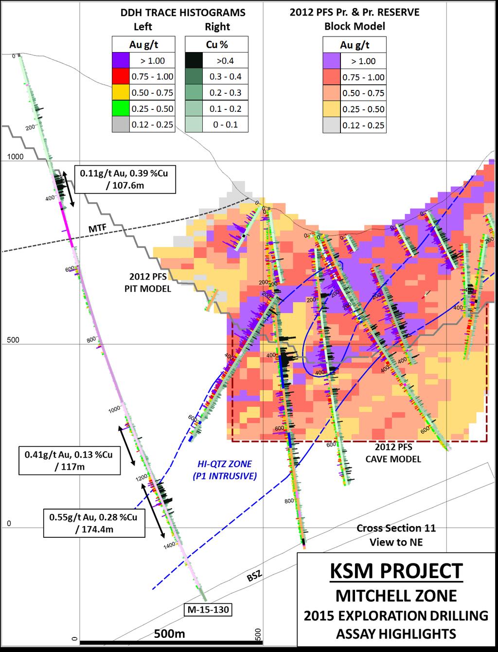
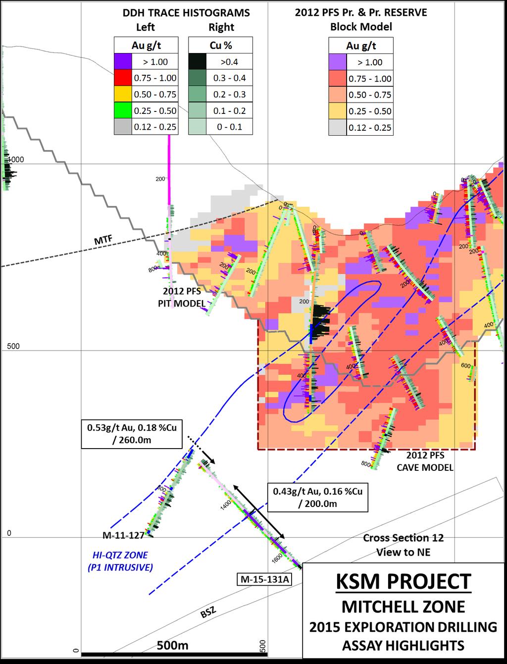
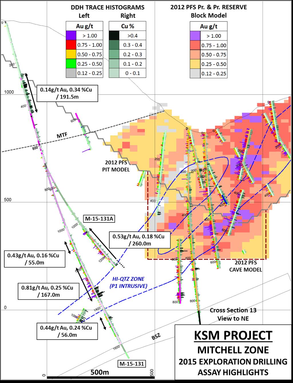
3 Mitchell In order to drill test the deep projection of the central zone and maintain orientations as close as possible at right angles to the interpreted mineralization trend, the holes were started well above and outside of the Mitchell Deposit reserve (see cross sections below). Directional drilling techniques were used down the hole to steer the holes to the target areas. The first two holes in this year's program confirmed continuity of mineralization in the panel above the Mitchell Thrust Fault (MTF) which hosts disseminated and veinlet chalcopyrite in magnetite skarn-style altered sediments and volcanics, a distal component of the Mitchell porphyry system. Intersects up to 192 meters wide grading 0.34% copper and 0.14 g/t gold support revisions of models that will enable conversion of waste to ore in Mitchell open pit scenarios which are planned to precede underground block caving. Below the Mitchell Thrust Fault, where the Mitchell reserves and resources are located, the holes encountered identical sections of altered intrusive rocks that are recognized as host to parts of the Mitchell Deposit. The intrusion is pervasively hydrothermally altered and contains abundant stock work quartz veins. Alteration increases systematically down hole, progressing through intense quartz-sericitepyrite and into chlorite-magnetite-orthoclase alteration. The intervals encountered in holes M and 131 pass through several phases of the Mitchell intrusive system, some of which contain gold and copper grades above the Mitchell Deposit average. Variable but mostly lower grades were encountered in a brecciated zone with abundant anhydrite, similar to the Bornite Breccia intersected several hundred meters higher, but without bornite. This was intersected from in M , in M , and in M A. The geometry is consistent with the moderately northwest dipping orientation of the bornite breccia, however copper and gold grades tend to be higher along the up-dip contact of the zone. This structure is interpreted as a late feature that controlled flow of hydrothermal fluids with an advanced argillic chemistry characteristic of the late stages of porphyry evolution. Bornite was confined mostly to shallower portions of the structure where cooler conditions favoured precipitation. Hole M A intersected a distinct medium to coarse grained, sub-porphyritic monzodiorite from to 1655m with grades below the Mitchell average. This intrusion is interpreted to be a later phase, with primary k-feldspar phenocrysts, an alteration mineral assemblage dominated by secondary k-feldspar, magnetite, epidote and traces of actinolite, and a poor development of stockwork quartz veins and sulfides. This low grade intrusion has been intersected in several other holes, but over much narrower widths suggesting the thickness in this hole reflects a local thickening or flexure and does not reflect the true volume of displaced higher grade. All three holes confirmed the presence of a roughly 50m thick, banded, mylonitic shear zone that may offset the base of the Mitchell deposit (Basal Shear Zone, BSF), seen previously only in hole M The zone dips to the northwest and appears to parallel the MTF. The following table summarizes the composited assay results for significant drill hole intersections from Mitchell zone drilling in In drill hole M , the Mitchell Thrust Fault is located at 601 meters and in M it is at 691 meters. M A was wedged off of M at 622.6m.

4 Hole ID M M M A Total Depth (m) From (m) To (m) Thickness (m) Au g/t (uncapped) Cu % (uncapped) Ag g/t (uncapped) Incl Incl Incl Incl Incl Incl Photographs of polished drill core samples representative of mineralization styles encountered in 2015 are shown below. Width of the core samples (vertical axis) is approximately 2.5cm. Cross sections and a level plan follow. HOLE-ID DEPTH Au g/t Cu % Mo % Ag g/t As ppm Pb ppm Zn ppm M Mitchell diorite porphyry, phyllic altered with D veins and Mo, no A or B veins with cp


5 HOLE-ID DEPTH Au g/t Cu % Mo % Ag g/t As ppm Pb ppm Zn ppm M Mitchell Breccia zone, altered P1B with anhy, py, cp but no bornite, average grade at this depth HOLE-ID DEPTH Au g/t Cu % Mo % Ag g/t As ppm Pb ppm Zn ppm M A Mitchell monzodiorite porphyry, later, coarser grained, calcic-potassic altered, A+B veins, low grade, may indicate lower limits of mineralization HOLE-ID DEPTH Au g/t Cu % Mo % Ag g/t As ppm Pb ppm Zn ppm M Mitchell Basal Shear Zone (BSZ): mylonitized rock, phyllic altered, low to nil grade
6
7
8
9
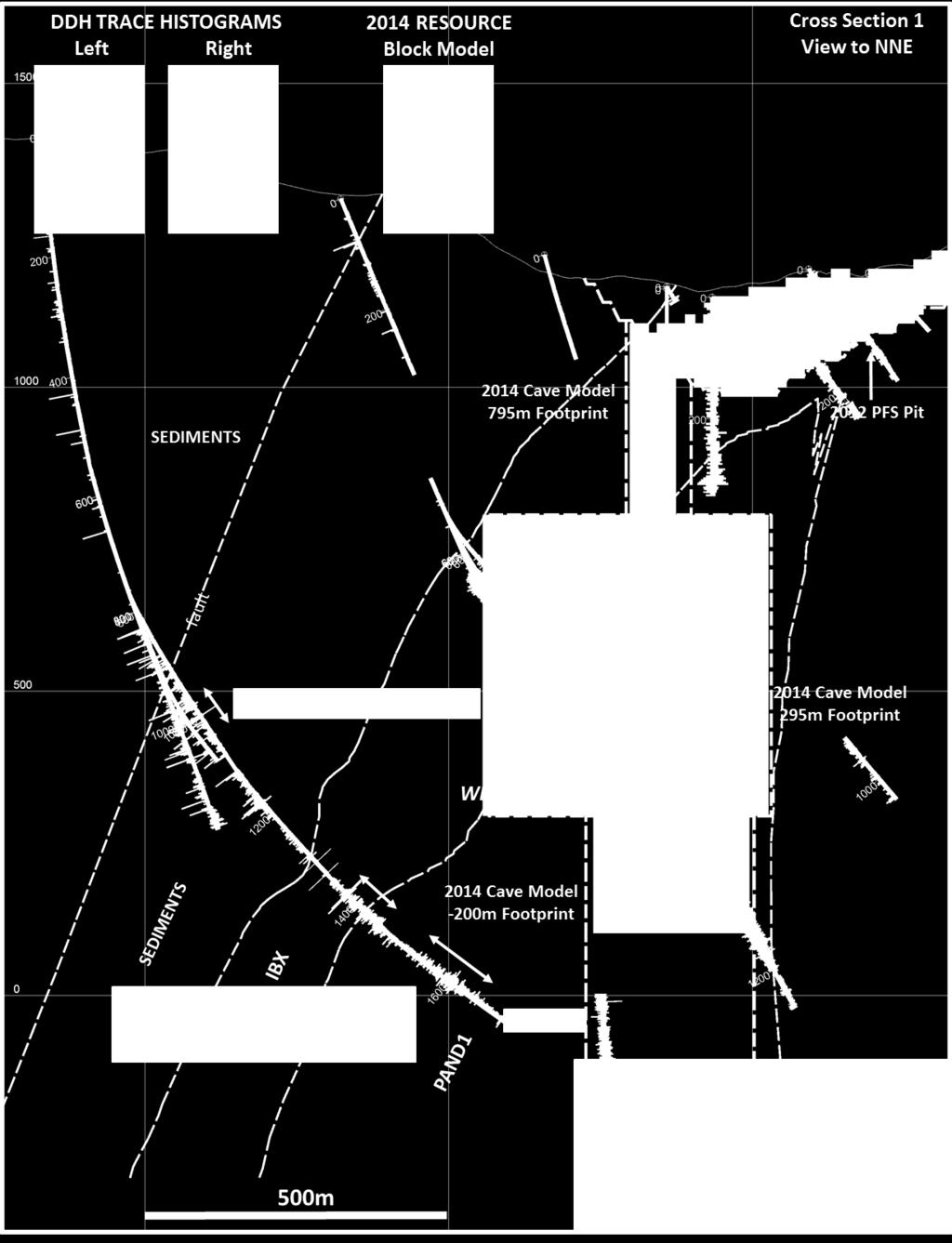
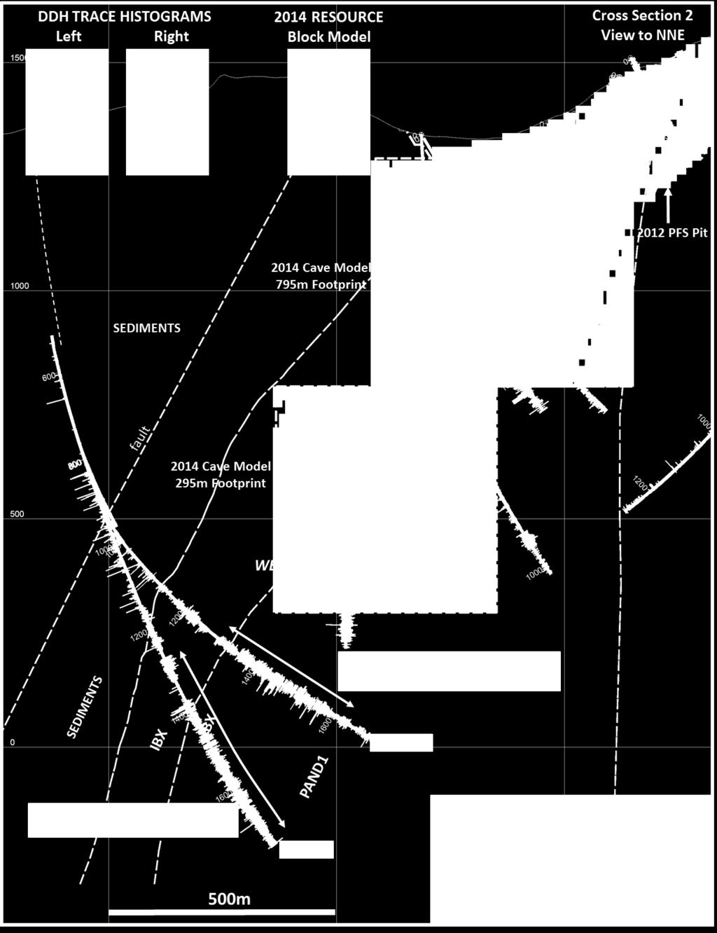
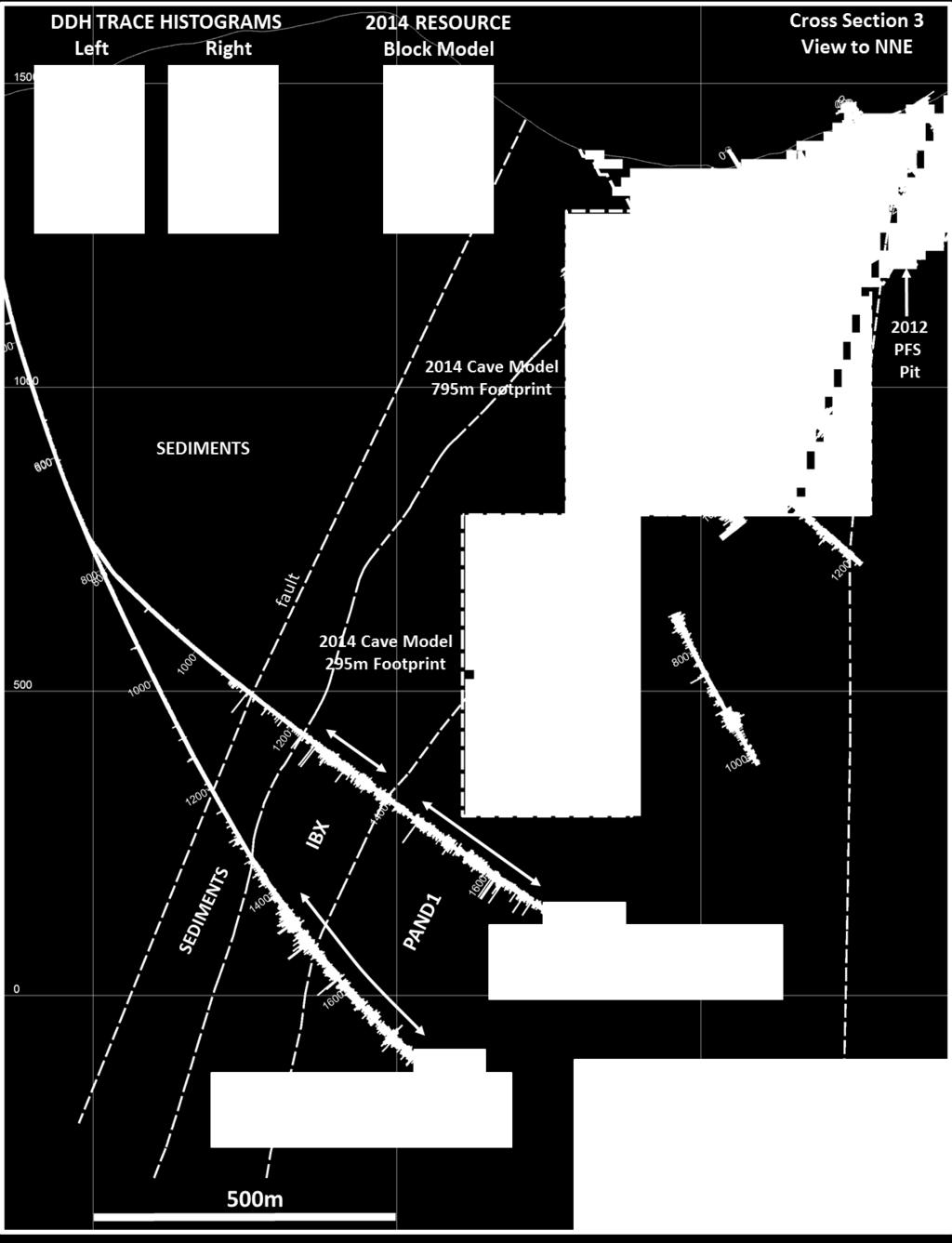
10 Deep Kerr The Kerr deposit is centered on a north-south trending, steep westerly dipping, tabular intrusive complex that drilling demonstrates has a horizontal extent of 2,400 meters and vertical extent of at least 2,200 meters. The complex includes an east and west limb that may coalesce near the current surface. The west limb is up to 500 meters thick, and the east limb up to 300 meters thick. There are several distinct intrusive phases, the earliest of which are fine grained diorites with 5% to 60% quartz-sulfide vein stockworks and these appear to contribute the majority of metals. Later phases envelope and sometimes invade the earlier phase, and are characterized by coarser textures, less veining, and lower metal contents. The intrusions are hosted by an Early Jurassic sequence of rhythmically bedded siltstones, sandstones, conglomerates, and debris flows that have been altered adjacent to the intrusions but generally contain marginal metal grades. The holes in this year's Deep Kerr program were collared well outside the mineral deposit in order to achieve the deep intersections that test the dip extension. Drill holes were designed to intercept the mineralized target at right angles to the strike of the zone and downhole directional drilling tools were used to steer the holes to target areas. These locations better defined the western limits of the mineralized system, and demonstrate that a north-south trending normal fault places unaltered finegrained sedimentary rock against the outer weakly mineralized parts of the mineral system. As the drill holes advance to the east, alteration and mineralization increase as a series of potassically-altered intrusions are encountered. Drill hole K passed out of the intensely altered and mineralized zone into younger intrusions with lower concentrations of gold and copper. The drill hole was not extended into the eastern high-grade zone encountered in previous shallower drilling because projected depths would have been prohibitive. This eastern zone remains a high potential target. The holes drilled this year confirmed a high degree of continuity of mineralization over very considerable distances. Holes K and K-15-49A confirmed down-dip extension of the strong mineralization in the west limb intersected by hole K-14-45, an oblique hole that cut 503m grading 0.40g/t Au and 0.67% Cu. This mineralization occurs mainly in the PAND1 diorite, the early mineralizing phase of the Kerr intrusive complex. It is finer grained, exhibits a high chalcopyrite to pyrite ratio, has remnants of secondary potassic alteration now mostly overprinted by retrograde chloritic alteration, and a mostly intact stockwork of quartz-sulfide veinlets. Portions of the PAND1 intrusion are overprinted by phyllic alteration characterized by sericitization of mafic minerals, higher pyrite content, and higher Au and Cu grades. The later PAND2 diorite is coarser grained, with very few intact quartz veinlets, and a lower metal content. Wall rock sediments are mineralized adjacent to the intrusions, but generally lower grade. Currently the lithology model lumps moderately mineralized PAND2 dykes, breccias, and sediment intervals in the hanging wall of the PAND1 body into the IBX domain, however definition drilling is expected to enable resolution of this into finer components. A few meter-scale, late quartzcarbonate-sulfide veins with strong Au and elevated Cu, Pb, Zn, and As levels cut the intrusions and wall rocks, and indicate penetration of late advanced argillic fluids along steep fractures. Holes K and K-15-50A tested the west limb 200m on strike to the south of K and K-15-49A. Continuity of the mineralized PAND1 intrusion was confirmed, however on this section gold and copper grades are lower. This is attributed to a higher proportion of lower grade PAND2 intrusion, as well as weaker overprinting phyllic alteration. Hole K-15-49B tested the west limb 200m north of K-15-49, and lower grades were also found to be due to a lower proportion of the PAND1 intrusion.

11 The following table summarizes the drill hole intersections for Hole ID Total Depth (m) From (m) To (m) Thickness (m) Au g/t (uncapped) Cu % (uncapped) Ag g/t (uncapped) K Incl K-15-49A Incl K-15-49B Incl K Incl Incl K-15-50A Incl Photographs of polished drill core samples representative of mineralization styles encountered in 2015 are shown below. Width of the core samples (vertical axis) is approximately 2.5cm. Cross sections and a level plan follow. HOLE-ID DEPTH Au g/t Cu % Mo % Ag g/t As ppm Pb ppm Zn ppm K Kerr PAND1 diorite intrusion: early, fine grained, potassic altered diorite with mostly intact stockwork qtz-cp-py veins


12 HOLE-ID DEPTH Au g/t Cu % Mo % Ag g/t As ppm Pb ppm Zn ppm K-15-49B Kerr PAND1 diorite intrusion: early, fine grained, potassic altered diorite with mostly intact stockwork qtz-cp-py veins HOLE-ID DEPTH Au g/t Cu % Mo % Ag g/t As ppm Pb ppm Zn ppm K Kerr PAND1 diorite intrusion(?): intense phyllic overprint with abundant py, addition of Au and Cu HOLE-ID DEPTH Au g/t Cu % Mo % Ag g/t As ppm Pb ppm Zn ppm K Kerr PAND2 diorite intrusion: later, slightly coarser grained, potassic altered diorite with no stockwork qtz-cp-py veins, a few orphaned vein fragments assimilated from PAND1


13 HOLE-ID DEPTH Au g/t Cu % Mo % Ag g/t As ppm Pb ppm Zn ppm K-15-49B Kerr PAND2 diorite: later, coarser grained, potassic altered, no stockwork veins, a few orphaned vein fragments assimilated from PAND1 HOLE-ID DEPTH Au g/t Cu % Mo % Ag g/t As ppm Pb ppm Zn ppm K Kerr PAND2 diorite: later, coarser grained, potassic altered, stockwork veins, a few orphaned vein fragments assimilated from PAND1 HOLE-ID DEPTH Au g/t Cu % Mo % Ag g/t As ppm Pb ppm Zn ppm K Kerr Sediments: chloritic-hornfels altered wall rocks, mostly fracture or breccia controlled and disseminated, low-grade mineralization
14
15
16
17
18
19
COPPERSTONE RESOURCES AB INTERCEPTS ZONE OF CHALCOPYRITE-ARSENOPYRITE- BORNITE MINERALIZATION AT SVARTLIDEN IN FIRST DEEP DRILLHOLE FROM 720m-810m
 COPPERSTONE RESOURCES AB INTERCEPTS ZONE OF CHALCOPYRITE-ARSENOPYRITE- BORNITE MINERALIZATION AT SVARTLIDEN IN FIRST DEEP DRILLHOLE FROM 720m-810m In mid-january 2017 Copperstone Resource published a geological
DISCOVERY OF MINERALISED PORPHYRY & MAGNETITE-COPPER-GOLD AT KAMARANGAN
 MEDUSA MINING LIMITED ABN: 60 099 377 849 Unit 7, 11 Preston Street Como WA 6152 PO Box 860 Canning Bridge WA 6153 Telephone: +618-9367 0601 Facsimile: +618-9367 0602 Email: admin@medusamining.com.au Internet:
ASX Announcement. 28 January Drill results indicate large Porphyry Copper Gold System at Peenam
 ASX Announcement 28 January 2010 Drill results indicate large Porphyry Copper Gold System at Peenam Highlights: 270 metres of visible copper (gold) mineralisation in first diamond core hole at Peenam Prospect
Discovery of Thick Zone of Magnetite-Rich M Veins Strengthens Potential for Nearby Porphyry
 Thursday s Gossan Copper-Gold Porphyry Diamond Drilling Update Discovery of Thick Zone of Magnetite-Rich M Veins Strengthens Potential for Nearby Porphyry ~100m intercept of magnetite-rich M -veins and
Magmatic-Hydrothermal Gold Systems in the Archean of Northern Ontario, Canada: Examples of Syenite-Associated and Porphyry-Type Au-(Cu) Deposits
 Deposits") Magmatic-Hydrothermal Gold Systems in the Archean of Northern Ontario, Canada: Examples of Syenite-Associated and Porphyry-Type Au-(Cu) Deposits By Dr. Daniel J. Kontak Department of Earth Sciences Laurentian
Magmatic-Hydrothermal Gold Systems in the Archean of Northern Ontario, Canada: Examples of Syenite-Associated and Porphyry-Type Au-(Cu) Deposits By Dr. Daniel J. Kontak Department of Earth Sciences Laurentian
For personal use only
 ASX ANNOUNCEMENT 6th February 2012 HIGH GRADE AU-CU INTERSECTIONS FROM KUINI PROSPECT IN ACEH ASX: PSP SHARE INFORMATION Issued Shares: 346.54m Unlisted Options: 20.95m BOARD OF DIRECTORS Chairman & MD:
For personal use only
 ASX ANNOUNCEMENT 2nd February 2012 PROMISING DRILLING RESULTS FROM KUINI PROSPECT IN ACEH ASX: PSP SHARE INFORMATION Issued Shares: 346.54m Unlisted Options: 20.95m BOARD OF DIRECTORS Chairman & MD: M.
Evaluating the Intrusion-Related Model for the Archean Low-Grade, High- Tonnage Côté Gold Au(-Cu) Deposit
 Deposit") Evaluating the Intrusion-Related Model for the Archean Low-Grade, High- Tonnage Côté Gold Au(-Cu) Deposit L.R. Katz, D.J. Kontak, Laurentian University, B. Dubé, V. McNicoll, Geological Survey of Canada
Evaluating the Intrusion-Related Model for the Archean Low-Grade, High- Tonnage Côté Gold Au(-Cu) Deposit L.R. Katz, D.J. Kontak, Laurentian University, B. Dubé, V. McNicoll, Geological Survey of Canada
CSA Mine Observations Applied to the Development of Regional Exploration Models
 CSA Mine Observations Applied to the Development of Regional Exploration Models 1 Introduction Recent work completed by the geology team has resulted in an improved understanding of the CSA mine system
it AUSIMM COBAR MINING SEMINAR
 Straits Resources Limited it AUSIMM COBAR MINING SEMINAR Brownfields Exploration at Girilambone: Understanding the Mineralised Systems August 2010 Phil Shields / Phil Jones LOCATION TRITTON OPERATIONS
MORE HIGH-GRADE GOLD INTERSECTIONS FROM CITADEL S SHAYBAN PROJECT, SAUDI ARABIA
 Citadel Resource Group Limited ASX Release 7th July 2009 MORE HIGH-GRADE GOLD INTERSECTIONS FROM CITADEL S SHAYBAN PROJECT, SAUDI ARABIA Highlights: LATEST RC IN-FILL AND EXTENSIONAL DRILLING CONTINUES
LINGIG PORPHYRY COPPER DISCOVERY
 MEDUSA MINING LIMITED ABN: 60 099 377 849 Unit 7, 11 Preston Street Como WA 6152 PO Box 860 Canning Bridge WA 6153 Telephone: 618-9367 0601 Facsimile: 618-9367 0602 Email: admin@medusamining.com.au Internet:
SECOND DRILL HOLE IHAD2 INTERSECTS MINERALIZED TAPLEY HILL FORMATION AND MINERALIZED BASEMENT IRON FORMATION
 Suite 304, 22 St Kilda Road St Kilda Vic 3182 Ph: +61 3 9692 7222; Fax: +61 3 9529 8057 For Immediate Release 14 th September 2007 SECOND DRILL HOLE IHAD2 INTERSECTS MINERALIZED TAPLEY HILL FORMATION AND
The Cobalt Rainbow. Airborne geophysical maps show that a north trending aeromagnetic high suggests further undiscovered mineralisation.
 The Cobalt Rainbow The property is located on Greenstone Creek, approximately 4.8 kilometres south west of the creek mouth. The property is located about 24 km due west of Campbell River, in the east-central
Using 3D/4D modeling tools in exploration of gold-polymetallic potential areas in Greece
 Using 3D/4D modeling tools in exploration of gold-polymetallic potential areas in Greece Arvanitidis N.D., Michael C., Weihed P., Gaál l G., Royer J.J., Perantonis G., Bakalis V., Ballas D. and Christidis
Copperstone Technical Report Update on 2018 Drilling Campaign
 2018 Copperstone Technical Report Update on 2018 Drilling Campaign Chris McKnight Copperstone Resources AB 5/16/2018 Highlights Mineralisation consisting of interspersed chalcopyrite veins (assay results
Amador Canyon Silver Mining Property Lander County, NV
 Amador Canyon Silver Mining Property Lander County, NV Over $1 million worth of exploration and evaluation work performed Favorable drill results including a return of 286 g/ton silver over 12.2 meters
Northparkes Forty Years on and Still Prospective
 Northparkes Forty Years on and Still Prospective September 2010 Location Tailings Impoundment E22 Pit E27 Pit Tailings Impoundment COBAR PARKES SYDNEY Dumps MINE LEASE E48 Deposit Plant Site Conveyor SITE
What is a Porphyry Copper Deposit?
 What is a Porphyry Copper Deposit? by David F. Briggs Over the last several years, many of you have probably heard the term porphyry copper and wondered what everyone is talking about. Porphyry copper
SIMUKU DRILLING TO OVER 1000 METRES DEMONSTRATES SIGNIFICANTLY INCREASED TONNAGE POTENTIAL OF THE INFERRED RESOURCE
 ADDRESS PHONE PO Box 6965 +61(07) 5592 1001 Gold Coast Mail Centre FAX Qld 9726 Australia +61 (07) 5592 1011 EMAIL ABN 54 126 490 855 info@coppermoly.com.au WEBSITE www.coppermoly.com.au ASX Announcement
EXISTING GEOLOGICAL INFORMATION
 CHAPER 3 EXISTING GEOLOGICAL INFORMATION 3-1 General Geology of the Surrounding Area (1) General geology and ore deposits in Mongolia Geographically, Mongolia is a country located between Russia to the
Queensland Mining Corporation Limited
 Queensland Mining Corporation Limited ABN 61 109 962 469 ASX Release 29 th July 2011 Drilling Commenced at Duck Creek Copper-Gold Project, Cloncurry, North-west Queensland Highlights RC drilling has commenced
Encouraging drill results from Paroo Range
 17 July 2012 The Manager ASX Company Announcements Office PO Box H224, Australia Square SYDNEY NSW 2001 Encouraging drill results from Paroo Range Highlights Significant uranium mineralisation at the 100%
Rich Saddle North Au-Cu-Ag Porphyry Expands by 275m Along Strike and 250m Down-Dip
 GT Gold Drills 281 Metres of 0.65 g/t Au, 0.38% Cu, 1.38 g/t Ag (1.24 g/t AuEq 1 ) Within 685 Metres 2 of 0.40 g/t Au, 0.26% Cu, 1.03 g/t Ag (0.81 g/t AuEq) in Step-out Hole TTD098 Rich Saddle North Au-Cu-Ag
ASX / MEDIA RELEASE 6 MAY MILE SILVER-LEAD-ZINC DISCOVERY; HIGH GRADE SILVER-GOLD IN ROCK CHIPS AT RUBY SILVER
 ASX / MEDIA RELEASE 6 MAY 2011 4-MILE SILVER-LEAD-ZINC DISCOVERY; HIGH GRADE SILVER-GOLD IN ROCK CHIPS AT RUBY SILVER Highlights: Silver-lead-zinc discovery at 4-Mile; mineralisation intersected in all
ENCOURAGING GOLD-BASE METALS AT MAY DAY, MOLY- GOLD AT ATTUNGA
 ASX / MEDIA RELEASE 5 JULY 2010 ENCOURAGING GOLD-BASE METALS AT MAY DAY, MOLY- GOLD AT ATTUNGA Peel Exploration is pleased to announce that recent drilling at the Company s Attunga and May Day projects
2. The latter two intersections occur outside the presently defined mineral resource.
 Avidian Drills 67 m of 4.93 g/t Au, includes 39.8 m of 7.54 g/t Au, at Golden Zone Property, Alaska & Discovers New Zone Northeast of the Breccia Pipe Deposit (Toronto, Ontario January 18, 2018) Avidian
3. GEOLOGY. 3.1 Introduction. 3.2 Results and Discussion Regional Geology Surficial Geology Mine Study Area
 3. GEOLOGY 3.1 Introduction This chapter discusses the baseline study of the geology and mineralization characteristics of the mine study area. The study consolidates existing geological data and exploration
Figure 1: Location of principal shallow conductors at Alpala (anomalies C0-C10; 5 Ohm/m surfaces, red) and shallow zones of electrical chargeability
 and shallow zones of electrical chargeability") Figure 1: Location of principal shallow conductors at Alpala (anomalies C0-C10; 5 Ohm/m surfaces, red) and shallow zones of electrical chargeability (85 msecs, yellow-green) shown on iso-surfaces of MVI
Figure 1: Location of principal shallow conductors at Alpala (anomalies C0-C10; 5 Ohm/m surfaces, red) and shallow zones of electrical chargeability (85 msecs, yellow-green) shown on iso-surfaces of MVI
Uncovering The Riches of the Abitibi Greenstone Belt of Canada
 1 TSX.V: ALZ June 2016 Uncovering The Riches of the Abitibi Greenstone Belt of Canada The Haultain Gold Discovery The Abitibi Greenstone Belt & Gold 170+ million oz of gold produced to date from more than
Petrological Studies by Terry Leach at the North Carlin Trend, Nevada. Keith Bettles October 17, 2008
 Petrological Studies by Terry Leach at the North Carlin Trend, Nevada Keith Bettles October 17, 2008 North Carlin Trend From 1999 to 2003 Terry Leach studied the Betze and Meikle ore bodies for Barrick
Tameapa Regional Geology
 Tameapa Project 1 Tameapa Regional Geology History San Francisco Mines of Mexico Ltd. (San Francisco), which completed an exploration program, including six drill holes (1,157 m) between 1956 and 1959.
Ore deposits related to intermediate to felsic intrusions Porphyry Base Metal (Cu-Mo) Deposits. - GLY 361 Lecture 7
 Deposits. - GLY 361 Lecture 7") Ore deposits related to intermediate to felsic intrusions Porphyry Base Metal (Cu-Mo) Deposits - GLY 361 Lecture 7 Ore deposits related to intermediate to felsic intrusions Deposits associated with the
Ore deposits related to intermediate to felsic intrusions Porphyry Base Metal (Cu-Mo) Deposits - GLY 361 Lecture 7 Ore deposits related to intermediate to felsic intrusions Deposits associated with the
Cowal Gold Corridor Opening Other Doors
 Cowal Gold Corridor Opening Other Doors 1 Objectives The Doors of the Corridor local geology of Cowal Gold Corridor Styles and controls on mineralisation within the Corridor Vein paragenesis Summary of
Quaternary clays alluvial sands of the Shepparton Formation overlie the basement rocks.
 NAGAMBIE GOLDFIELD Regional Geological Setting The Nagambie Project is located within the Melbourne Structural Zone of Victoria. The lithologies range in age from the Upper Silurian Broadford Formation
A1 GOLD MINE 14 LEVEL STOCK WORKS TARGET FURTHER HIGH GRADE DRILL INTERCEPTS
 Heron Resources Limited ABN: 30 068 263 098 Level1, 37 Ord Street, West Perth WA 6005 Phone: +61 (0) 8 9215 4444 Website: www.heronresources.com.au Email: info@heronresouces.com.au ASX: HRR ASX Release
December 2017 Quarter Activities Report
 December 2017 Quarter Activities Report ABOUT ARC EXPLORATION LIMITED Arc Exploration Limited (ASX Code: ARX) is an Australian-listed company focused on gold and base metal exploration in Indonesia and
Golden Cross Resources
 Golden Cross Resources Labrador Uranium Joint Venture with Altius Resources Update - November 2007 Labrador Uranium - Canada LABRADOR URANIUM PROPERTIES Golden Cross Resources signed an agreement with
For personal use only
 ACN 097 088 689 ASX Announcement 1 EXPLORATION SUCCESS CONTINUES AT RAVENSWOOD RC drilling targeting shallow portions of Welcome breccia returns a number of significant new results including: 7m @ 7.84g/t
ATON RETURNS 22.2 METRES OF 2.77 GRAMS PER TONNE GOLD EQUIVALENT FROM HAMAMA WEST; VISIBLE GOLD DISCOVERED AT BOHLOG
 FOR IMMEDIATE RELEASE: ATON RETURNS 22.2 METRES OF 2.77 GRAMS PER TONNE GOLD EQUIVALENT FROM HAMAMA WEST; VISIBLE GOLD DISCOVERED AT BOHLOG Vancouver, April XX, 2017: Aton Resources Inc. (AAN: TSX-V) (
SPL 1452 NAMOLI & WAINIVAU GOLD AND COPPER PROSPECTS
 SPL 1452 NAMOLI & WAINIVAU GOLD AND COPPER PROSPECTS (Multiple Namosi-like Exploration Targets) SPL1452 being contiguous with the Namosi SPL1420 owned by the Newcrest Joint Venture and with the same type
2017 Geophysical Survey Report
 2017 Geophysical Survey Report Copperstone Resources AB Synopsis Copperstone Resources AB (publ) ( Copperstone or the Company ) has recently completed an extensive geophysical survey on the 100% owned
ARGENTINE FRONTIER RESOURCES INC (AFRI) SALTA EXPLORACIONES SA (SESA)
 SALTA EXPLORACIONES SA (SESA)") ARGENTINE FRONTIER RESOURCES INC (AFRI) SALTA EXPLORACIONES SA (SESA) LA SARITA IOCG-Porphyry Copper-Gold August 2006 La Sarita Cateo 2 La Sarita - bleached center is Taca Taca Arriba. The hematite zone
ARGENTINE FRONTIER RESOURCES INC (AFRI) SALTA EXPLORACIONES SA (SESA) LA SARITA IOCG-Porphyry Copper-Gold August 2006 La Sarita Cateo 2 La Sarita - bleached center is Taca Taca Arriba. The hematite zone
VECTORING VOLCANOGENIC MASSIVE SULPHIDE MINERALIZATION AT THE RAINDROP ZONE, SNOW LAKE (NTS 63K16), MANITOBA by G.H. Gale
, MANITOBA by G.H. Gale") GS-8 VECTORING VOLCANOGENIC MASSIVE SULPHIDE MINERALIZATION AT THE RAINDROP ZONE, SNOW LAKE (NTS 63K16), MANITOBA by G.H. Gale Gale, G.H. 2002: Vectoring volcanogenic massive sulphide mineralization at
GS-8 VECTORING VOLCANOGENIC MASSIVE SULPHIDE MINERALIZATION AT THE RAINDROP ZONE, SNOW LAKE (NTS 63K16), MANITOBA by G.H. Gale Gale, G.H. 2002: Vectoring volcanogenic massive sulphide mineralization at
CAMBRIAN INTRUSION-RELATED COPPER MINERALISATION AT THE THOMAS CREEK PROSPECT, SOUTHWESTERN TASMANIA
 CAMBRIAN INTRUSION-RELATED COPPER MINERALISATION AT THE THOMAS CREEK PROSPECT, SOUTHWESTERN TASMANIA UN I VF.RS TTY OF TASMANIA By Robert Reid (B.Sc. Hons) A thesis submitted in partial fulfillment of
MEMO. TO: Dennis Lapoint CC: FROM: Eriaan Wirosono DATE: April, 20 th 2014 SUBJECT: Exploration activity report March-April 2014_EW
 TO: Dennis Lapoint CC: FROM: Eriaan Wirosono DATE: April, 20 th 2014 SUBJECT: Exploration activity report March-April 2014_EW MEMO 1. Highlights and Productivity Overview pan sampling on target Areas 1
OPOSURA PROJECT, MOCTEZUMA, SONORA, MÉXICO, A HIGH GRADE ZN-PB, AG (CU, MO), ADVANCED STAGE, SKARN DEPOSIT (34) Expositor Día Hora Sala
, ADVANCED STAGE, SKARN DEPOSIT (34) Expositor Día Hora Sala") OPOSURA PROJECT, MOCTEZUMA, SONORA, MÉXICO, A HIGH GRADE ZN-PB, AG (CU, MO), ADVANCED STAGE, SKARN DEPOSIT (34) Expositor Día Hora Sala Cruz Paez Viernes 26 12:30 13:00 Sala A Cruz Enrique Paez Minera
OPOSURA PROJECT, MOCTEZUMA, SONORA, MÉXICO, A HIGH GRADE ZN-PB, AG (CU, MO), ADVANCED STAGE, SKARN DEPOSIT (34) Expositor Día Hora Sala Cruz Paez Viernes 26 12:30 13:00 Sala A Cruz Enrique Paez Minera
For personal use only
 8 November 2011 Gunung Rosa Vein System extended to over 2 kilometres in strike length Highlights Rock chip sample analyses demonstrate high grade gold, silver and base metals which extend the strike length
Copper and Zinc Production, Disciplined Growth. S I T E V I S I T O C T O B E R % Owned Projects
 Copper and Zinc Production, Disciplined Growth. S I T E V I S I T O C T O B E R 2 0 1 6 100% Owned Projects Serbia assets Timok Magmatic Complex Rakita Joint Venture 4 exploration permits in the Bor region,
FIRST YEAR ASSESSMENT REPORT PROSPECTING LICENCE 16512M MARYSTOWN AREA, BURIN PENINSULA NTS 1M/3
 FIRST YEAR ASSESSMENT REPORT OF PROSPECTING ON LICENCE 16512M MARYSTOWN AREA, BURIN PENINSULA NTS 1M/3 BY NATHANIEL NOEL MSc. FOR E. MICHELE NOEL MINERAL LICENCES: 16512 M WORK CONDUCTED: MID-SEPTEMBER
Geology, Alteration and. Petrogenesis
 The Mutooroo Copper Deposit: Geology, Alteration and Petrogenesis Graham S. Teale Consultant t Andrew T. Price Havilah Resources NL The speaker would like to thank Havilah Resources NL for the opportunity
Carrapateena Mineral Resources Explanatory Notes April OZ Minerals Limited. Carrapateena Mineral Resources Statement April
 OZ Minerals Limited Carrapateena Mineral Resources Statement April 14 2011 CARRAPATEENA MINERAL RESOURCE STATEMENT April 14, 2011 The Carrapateena Resource Statement relates to an upgrading to an Inferred
Alteration and Mineralization at Daralu Porphyry Copper Deposit, South of Kerman, Southeast Iran
 Alteration and Mineralization at Daralu Porphyry Copper Deposit, South of Kerman, Southeast Iran Mosayeb Salehian* and Majid Ghaderi Department of Geology, Tarbiat Modares University, Tehran, Iran *Email
Elverdton Copper-Gold Project Ravensthorpe, Western Australia
 FOR SALE or JV Elverdton Copper-Gold Project Ravensthorpe, Western Australia Summary: The Elverdton Copper-Gold Project is located approximately 11 kilometres south-east of Ravensthorpe town, which is
For personal use only
 ASX RELEASE 13 July 2012 ASX Code: PMQ Encouraging Field Exploration Results: Mount Borium Gold Project Key Points Third phase of field exploration underway the Company has been highly active since the
JV Project Portfolio Executive Summary: Bruce Smith
 JV Project Portfolio Executive Summary: Bruce Smith September 5, 2012 Disclaimer Forward-Looking Statements This presentation contains forward-looking statements, including but not limited to comments
Exploring in the last frontier: Skarn mineralisation, Attunga District, NSW
 BROVEY MAPPING SERVICES Exploring in the last frontier: Skarn mineralisation, Attunga District, NSW Latest exploration findings and interpretations Nancy Vickery, Joshua Leigh and Michael Oates Outline
Geochemical exploration on the Tareek Darreh Gold deposit, north of Torbat-e Jaam, east Iran
 Geochemical exploration on the Tareek Darreh Gold deposit, north of Torbat-e Jaam, east Iran Kourosh Shabani, M.Sc. Student of Economic Geology, Islamic Azad University, Science and Research Branch, Tehran,
IVANHOE DISCOVERS IMPORTANT NEW GOLD-COPPER PORPHYRY DISTRICT IN SOUTHERN MONGOLIA NEW PORPHYRY DISTRICT NOW NAMED BRONZE FOX
 November 29, 2004 IVANHOE DISCOVERS IMPORTANT NEW GOLD-COPPER PORPHYRY DISTRICT IN SOUTHERN MONGOLIA NEW PORPHYRY DISTRICT NOW NAMED BRONZE FOX ULAANBAATAR, MONGOLIA Ivanhoe Mines Chairman Robert Friedland
JOSH LEIGH Project Exploration Geologist June ASX Code AIV
 COALSTOUN AND BOOUBYJAN Porphyry Copper-Gold Complexes, their structural setting, geology and geochemistry Joshua Leigh 1, Doug Young 2, Jose Veracruz 3, Paul Ashley 3 - ( 1 ActivEX Limited, 2 Consultant,
For personal use only
 ANNOUNCEMENT TO THE AUSTRALIAN SECURITIES EXCHANGE: 28 NOVEMBER 2012 DRILLING UPDATE MABILO PROJECT The Directors of Sierra Mining Limited ( Sierra ) are pleased to announce further results from reconnaissance
WEST MCARTHUR UPDATE April 17, Table 1: Winter 2018 Drill Hole Summary
 WEST MCARTHUR UPDATE April 17, 2018. Table 1: Winter 2018 Drill Hole Summary WMA044: Sooty pyrite alteration is disseminated along local beds and coats local fractures between 401.2 m and 724 metres. A
TERAS FLAGSHIP CAHUILLA PROJECT
 TERAS FLAGSHIP CAHUILLA PROJECT Cahuilla Company s Main Asset is located in mining friendly Imperial County, California. Mine Development Associates completed a NI 43-101 resource report; reporting an
Drilling Program Commences on Iron Oxide Copper Gold Targets
 3 June 2008 Manager Company Announcements Company Announcements Office Australian Stock Exchange Limited Level 10, 20 Bond Street SYDNEY NSW 2000 ABN 42 082 593 235 Electronic delivery No of pages: 6 Drilling
Exploring the Mande Batholith. November 15, 2017
 Exploring the Mande Batholith November 15, 2017 Minera Cobre de Colombia (MCC) MCC controls a highly prospective porphyry Cu portfolio covering 3,300 km 2 in 145 mineral concessions within 200 km strike
High Grade Gold Intercepts at Bangaba
 20th March 2012 ASX Announcement High Grade Gold Intercepts at Bangaba Level 2, 9 Colin Street West Perth WA 6005 ABN 11 127 171 877 p (08) 9216 1000 f (08) 9481 7939 w www.predictivediscovery.com e info@predictivediscovery.com
For personal use only
 10 July 2012 Encouraging New Gold Results from Gunung Rosa Drilling Highlights Assay results from three drill holes at depth under the Cap Palu section confirm significantly wider intercepts of gold-copper-base
MINERAL DEPOSITS OF THE COBAR BASIN
 MINERAL DEPOSITS OF THE COBAR BASIN 360 hard rock deposits in Cobar Basin Cu, Au, Ag, Pb, Zn combinations and quartz-au veins Cobar 23 major deposits in Cobar Basin World class Endeavor mine World class
Update on Chillagoe Mining District Research: Dec 7, 2017
 Update on Chillagoe Mining District Research: Dec 7, 2017 Peter Illig 1, Zhaoshan Chang 1 1 EGRU James Cook University, Townsville QLD 4811, Australia Introduction to Chillagoe Deposits Regional introduction
Narrow High-Grade Gold and Long Low-Grade Porphyry Gold and Copper-Gold Intercepts at Bulago
 CONTACTS PHONE EMAIL PO Box 52 +61 (08) 9295 0388 info@frontierresources.com.au West Perth FAX WEBSITE WA 6872 Australia +61 (08) 9295 3480 www.frontierresources.com.au ASX Limited Company Announcements
Summary of Rover Metals Geologic Mapping Program at the Up Town Gold Project, Northwest Territories
 October 13, 2017 Summary of Rover Metals Geologic Mapping Program at the Up Town Gold Project, Northwest Territories Vancouver, British Columbia, Canada - Rover Metals Corp., Rover, is pleased to provide
Regional geology map showing drill holes completed to date and hole RZDDH10 08 in progress, IP Chargeability anomalies hatched.
 Alteration Haloes Alteration facies in the Suarez-Misahuallí basin on the east side of the Rio Zarza gold project are complex, as they oerlap in time and space, are the result of weathering, diagenetic,
COMMANDER RESOURCES LTD.
 COMMANDER RESOURCES LTD. October Dome Gold Skarn Mt Polley Core Facility February 2016 1 August 2016 CORPORATE DISCLOSURE Disclaimer The information contained herein, while obtained from sources which
Zinc Skarns of the Chillagoe District NE Queensland (A snap shot)
") Zinc Skarns of the Chillagoe District NE Queensland (A snap shot) Mines and Wines 2015 Queanbeyan Skarn Classifications Major Metals, Host Rocks, Intrusive Source Zinc Calcic (limestone prograde grandite
Zinc Skarns of the Chillagoe District NE Queensland (A snap shot) Mines and Wines 2015 Queanbeyan Skarn Classifications Major Metals, Host Rocks, Intrusive Source Zinc Calcic (limestone prograde grandite
NEW COBAR-STYLE COPPER DISCOVERY IN NSW
 ASX / MEDIA RELEASE 2 AUGUST 2011 NEW COBAR-STYLE COPPER DISCOVERY IN NSW Broad zone of copper-polymetallic mineralisation intersected at 4-Mile prospect Highlights: Wide zone of copper-silver-gold-lead-zinc
102 metres strike length averaging 32.62g/t Gold extends overall surface vein sampling to date to 726 metres strike length averaging 24.
 ASX ANNOUNCEMENT / MEDIA RELEASE ASX:ABU 8 th February 2012 Old Pirate Phase 4 Longitudinal Trenching Results for veins on the Western Limb Lodes 102 metres strike length averaging 32.62g/t Gold extends
For personal use only
 ASX QUARTERLY REPORT GEOPACIFIC RESOURCES NL ACN 003 208 393 ASX Code: GPR info@geopacific.com.au www.geopacific.com.au AUSTRALIAN OFFICE Suite 6, 125 Melville Parade Como, WA 6152 SEPTEMBER 2012 QUARTERLY
Dianne Mitchinson Mira Geoscience Exploration Undercover Geoscience BC/BC Geophysical Society shortcourse Vancouver, BC Oct 12-14, 2011
 Insights for Porphyry Exploration from Rock Properties Data: Examples from the QUEST and QUEST-West Project Areas Dianne Mitchinson Mira Geoscience Exploration Undercover Geoscience BC/BC Geophysical Society
HOWE COPPER MINE PROJECT HIGH GRADE Cu-Ag with Au
 HOWE COPPER MINE PROJECT HIGH GRADE Cu-Ag with Au The Howe Copper Mine property is located approximately 55 kilometres northwest of Vancouver, BC. It is situated at 1431 metres elevation on the eastern
RESULTS OF OPERATIONS Semi Annual Exploration Report BANLUNG EXPLORATION LICENSE, CAMBODIA FOR THE PERIOD 2015:06:30 TO 2015:12:31
 RESULTS OF OPERATIONS BANLUNG EXPLORATION LICENSE, CAMBODIA FOR THE PERIOD 2015:06:30 TO 2015:12:31 Introduction Work over the period has included the completion of a detailed induced polarization geophysical
SQUARE POST PROJECT CHARTERS TOWERS NORTH QUEENSLAND AUSTRALIA
 SQUARE POST PROJECT CHARTERS TOWERS NORTH QUEENSLAND AUSTRALIA Square Post - Summary PROJECT DETAILS - SQUARE POST The Square Post exploration permit (EPM 18510) contains two styles of mineralisation:
Wind Mountain Project Summary Memo Feeder Program
 A Manex Resource Group Company Wind Mountain Project Summary Memo Feeder Program J.A. Kizis, Jr., February 07, 2018 Assays have been received for both holes drilled at Wind Mountain during late 2017 and
GEOLOGY OF THE NICOLA GROUP BETWEEN MISSEZULA LAKE AND ALLISON LAKE
 GEOLOGY OF THE NICOLA GROUP BETWEEN MISSEZULA LAKE AND ALLISON LAKE (92H/15E. 10E1 By V. A. Preto INTRODUCTION Mapping was continued southward from the area covered in 1973 and an additional 55 square
POTENTIAL OF THE DONGWE COPPER GOLD PROJECT
 POTENTIAL OF THE DONGWE COPPER GOLD PROJECT By Nathan Sabao, P.Geo. September 2015 1 TABLE OF CONTENTS Page 1.0 EXECUTIVE SUMMARY 1 2.0 LOCATION 2 3.0 ACCESS 2 4.0 GEOLOGY 3 5.0 PREVIOUS DRILLING 5 6.0
ZAMIA METALS LIMITED TARGETING GOLD & COPPER IN QUEENSLAND EXPLORATION STRATEGY, JULY 2016 JUNE June 2016 ASX:ZGM
 ZAMIA METALS LIMITED TARGETING GOLD & COPPER IN QUEENSLAND EXPLORATION STRATEGY, JULY 2016 JUNE 2017 June 2016 Introducing Zamia Metals Limited Listed on ASX since 2008 Package of Exploration Permits for
Pershimco Intercepts Porphyry Indicators Covering a Minimum 12 KM Strike at Cerro Quema, Panama
 Pershimco Intercepts Porphyry Indicators Covering a Minimum 12 KM Strike at Cerro Quema, Panama ROUYN-NORANDA, QUÉBEC August 13, 2014 Pershimco Resources Inc. (the Company or Pershimco ) (TSX-V: PRO; FSE:
LOS CALATOS DRILLING RESULTS TD2 TARGET
 ASX ANNOUNCEMENT 18 April 2016 LOS CALATOS DRILLING RESULTS TD2 TARGET Metminco Limited ( Metminco or the Company ) (ASX: MNC; AIM: MNC) advises that the drilling of a single drill hole at the TD2 Target
Press Release Azimut and Partners announce Drilling Results from Eleonore South Gold Property, James Bay region, Quebec
 For immediate release December 17, 2018 Symbol: AZM. TSX Venture Press Release Azimut and Partners announce Drilling Results from Eleonore South Gold Property, James Bay region, Quebec Longueuil, Quebec
Exploration and Discovery of the Caspiche Porphyry Gold-Copper Deposit, Maricunga Belt, Region III, Chile
 Exploration and Discovery of the Caspiche Porphyry Gold-Copper Deposit, Maricunga Belt, Region III, Chile Presenter - Glen van Kerkvoort Cautionary Statement Cautionary Note to U.S. Investors The United
Mishi Lake Gold Property Mishibishu Lake Area, Wawa
 Mishi Lake Gold Property Mishibishu Lake Area, Wawa Location, Accessibility, Infrastructure and Local Resources The property is located 40 km west of Wawa, Ontario, in the Mishibishu Lake Area, Sault Ste.
NEW GOLD AND COPPER DISCOVERY IN CENTRAL OYU ZONE AT TURQUOISE HILL PROJECT IN MONGOLIA S GOBI DESERT REGION
 For Immediate Release March 5, 2002 NEW GOLD AND COPPER DISCOVERY IN CENTRAL OYU ZONE AT TURQUOISE HILL PROJECT IN MONGOLIA S GOBI DESERT REGION HIGH-GRADE GOLD AND COPPER MINERALIZATION EXTENDED TO A
Stop 2 - aitik cu-au-ag mine. Roger Nordin Boliden Mineral AB, Boliden, Sweden. Christina Wanhainen Luleå University of Technology, Luleå, Sweden
 Stop 2 - aitik cu-au-ag mine Roger Nordin Boliden Mineral AB, Boliden, Sweden Christina Wanhainen Luleå University of Technology, Luleå, Sweden Riikka Aaltonen Boliden Mineral AB, Boliden, Sweden The Aitik
Titiribi Gold: Sleeping Giant in the Colombian Cordilleras (a Geophysical Study)
") Titiribi Gold: Sleeping Giant in the Colombian Cordilleras (a Geophysical Study) Emmett Van Reed, P.Gp. Zonge Engineering & Research Amit Tripathi, Ph.D. Terra Resources Development Technologies Jennifer
Titiribi Gold: Sleeping Giant in the Colombian Cordilleras (a Geophysical Study) Emmett Van Reed, P.Gp. Zonge Engineering & Research Amit Tripathi, Ph.D. Terra Resources Development Technologies Jennifer
The ALTPF: OTCQB 9AJ1: FWB Altiplano Provides 2017 Exploration Update For Its Maria Luisa and Farellon Projects, Chile
 November 9, 2017 APN: TSXV The ALTPF: OTCQB 9AJ1: FWB Altiplano Provides 2017 Exploration Update For Its Maria Luisa and Farellon Projects, Chile Edmonton, Alberta - November 9, 2017 - Altiplano Minerals
Geological l Aspects of the Prominent Hill Feasibility Study
 St Barbara s Day SA Explorers Conference Geological l Aspects of the Prominent Hill Feasibility Study DAVID WALLACE OXIANA LIMITED December 2005 Prominent Hill Best Copper- Gold Discovery of the Decade
Aliabad-Morvarid iron-apatite deposit, a Kiruna type example in Iran
 Aliabad-Morvarid iron-apatite deposit, a Kiruna type example in Iran Maryam-Sadat Mazhari 1 *, Majid Ghaderi 1, Mohammad-Hassan Karimpour 2 1 Department of Geology, Tarbiat Modares University, Tehran,
SUMBA EXPLORATION UPDATE
 ASX RELEASE Tuesday, 23 November 2010 SUMBA EXPLORATION UPDATE Hillgrove Resources Limited (ASX:HGO) today announces a planned airborne geophysical survey, Pelitalira prospect progress and final results
REGULUS REPORTS ADDITIONAL HIGH-GRADE RESULTS FROM THE ANTAKORI COPPER-GOLD-SILVER PROJECT, PERU
 REGULUS REPORTS ADDITIONAL HIGH-GRADE RESULTS FROM THE ANTAKORI COPPER-GOLD-SILVER PROJECT, PERU 619.2 metres with 0.67% Cu, 0.43 g/t Au and 7.3 g/t Ag (1.05% CuEq) including 135.7 metres with 2.17% Cu,
The MAPLE BAY PROJECT Copper Silver - Gold
 The MAPLE BAY PROJECT Copper Silver - Gold Good grade and tonnage potential within close proximity to Tidewater The Maple Bay Copper Silver Gold Project covers highly favourable geological host rocks of
* **
 MT. BULGA REVISITED Bob Whiteley* and Tak Ming Leung** * rjwhiteley@optusnet.com.au ** tak-ming_leung@rta.nsw.gov.au Mt Bulga is located near Orange, New South Wales some 260 km west of Sydney. The first