CAMP MINERAL CLAIM,, 1
|
|
|
- Gillian Long
- 5 years ago
- Views:
Transcription
1 CAMP MNERAL CLAM,, 1
2 . ~~, ~~...* , --, -. Province of British Columbia, ' ' ', P&&y:,i. ~,,,.,.,,', :,,, ' i, ;. Ministry of ' Energy, Mines and ASSESSMENT REPORT,,!" Petroleum Resources TTLE PAGE AND SUMMARY;! :,,,. n,!.rp 13 n, JSclLLG \.%....M.E.!?%,.. SlGNATURElSl ' DATE STATEMENT OF EXPLORATON AN0 DEVELOPMENT FLED A%!.?:.!? YEAR OF WORK!?% ~,,.. TYPE OF REPORT/SURVEYlSl 1,!;.,! :. - ", ' AUTHORS)...LAeo\/D'.,,,,,!,. 11; ',,, ' J,, 1,... PROPERJY NAME61...cA.w F!.*.. :... : : ~%lmodtes PRESENT....,;,,...:..., ' ' c :-~ :'. - ' ',(,, ', ', :, i,,, ' MNERAL NVENTORY NUMBER(S1, F KNOWN, i,., -.. MiNiNG:DiViSiON..KAMLOCPS..... NTs...??. :.?,%:....! LATTUDE... 50" 35' LONGTUDE... J200.!5'.:.... L NAMES and NUMBERS of all rnmeral tenurns in good standing lwhen work was donel that form fhn property [E~mple~: TAX 14, FRE 2, 12 units); PHOENX llot 17061; Mnneral Lease M 123; Mining or Certified Mlning bare ML 12 lclaims involved)] :... cp:m.?.:!....s?.?.+...; ! ::' 1,: -- OWNERlSl LLOYD E MEAR...*, ',. ( C" -- ~. MALNG ADDRESS XQ-CDC.?% PORT...?L> R!CrH3.O.w5!..a:c...YG.X OPERATORW lthat is. Company paymg for the work As..A\?.J.E , ' ,, : r MALNG ADDRESS L '', j!, 8 ',,, SUMMARY GEOLOGY lithology. age. slruc1ure. alteratton, rninurslization. ria& and 8tliudn):,,... G?+.+.G?.\.e-.?T%.... P.\.+?.Lf?C.C PA % NT.. bwj....,.,......, ( /.....,.,,. C dki.&t&.,, , ~...!. ',.( 2- " i,:,, /..,.. L _,,..~ 1...,," ('";.,Q....:.? '.i ' ' ',).;. A,.,,..:.!.,..;.,,,., i....,?, '.. ' REFERENCES TO PREVOUS WONK.....do. ~?%F~%?u.&.....*o%\!: f : ,...: 4
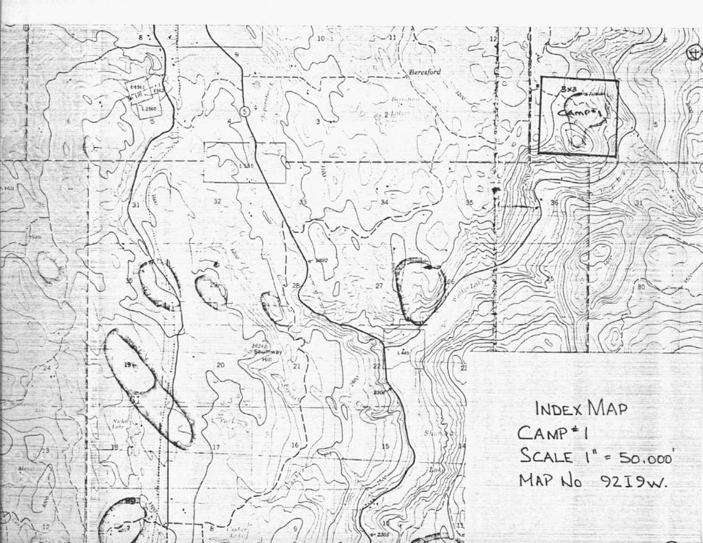
3 h. CAMP MNERAL CLAMS Table of Contents Page 1 Title Page 2 Table of Contents 3 ntroductbn 4 ndex Map 5 Cost Statement 6 Plan Map 7. Drill Log ACT ON: FLE NO: i GEOLOGCAL BRANCH ASSESSMENT TaqPCbRT
4 NTRODUCTON A. B. C. D. E. F. General Location - Kamloops Mining District, south on Hwy. #5, approximately 8 miles south of Knutsford to Campbell Creek Rd., then east on Campbell Creek Rd. for 6 miles. Property is covered with juvenile fir and pine timber with unimproved access road extending through th? Property. No known mineralized history available on claims. Current owner - Lloyd E. Mear No economic evaluation yet determined. Prospecting over claim area has produced: a. A number of float specimens indicating favourable mineralization. No outcrops containing mineralization have been discovered. b. nfra Red photography has indicated possible mineralieation as shown on index map. G. F.. 1 drill hole, HQ diameter has been drilled to 200 ft. The contents of such is yet to be assayed. - Drill logs and assays to be carried out at a later date and will follow this report. Drill core stored at 9551 Bridgeport Rd., Richmond, B.C.. Some samples taken to private lab for analysis. AUTHOR'S QUALFCATONS Lloyd E. Mear Managed underground mining and milling operation south of Houston, B.C Owned and operated placer gold operation in Yukon Territories Owned and operated constructbn company in U.S.A. and Canada

5
6
7 A. Contract drilling - $ per ft. X 200 ft. $5,000 (ncludes water hauling, mobilization & demobilization, core boxing, site rehahilitjltinn.) ~GCMG Coae~ 00 Site rehabilitatln - Grass seed, weed control 200 Travel, support staff, 20% -... i t
8 .. ' 1',,.'
9 Property: Dates Drilled: Dates Logged: Logged By: Drill Contractor: SUMMARY LOG FOR DAMOND DRLL HOLE 90-1 Carrq, 1 Claim Azimth: - Oct , 1990 Dip: Nov. 6, 1990 Depth: 200 ft. Ellen Larrbert, Geologist Core Size: NQ Nemac ndustries, Ltd. NTERVAL (feet) pescrptfon (rzamyorte - coarse grained granodiorite consisting of grey quartz, white to pink orthoclase, white to pale green plagioclase, black biotite (comnonly chloritized), and black hornblende. Mafic minerals account for 10-15% of the total mineral content. The rock is predominantly fresh except where noted below. Local calcite veinlets and chlorite along fracture faces; minor hematite. Mineralization consists of pixpetite (disseminated, $la), pyrite (disseminated and as tiny veinlets, (1% to 38, generally associated with chlorite and rnafics), and rare chalcopyrite. Local orange coloration to feldspars appears to be related to altered and sheared granodiorite (iron staining?), = = = = Fresh Granodiorite, but poor recovery (average 54%); core moderately broken, but no evidence of gouge or brecciation. Minor pyrite, rare chalcopyrite. Fault Zone - strong brecciation and clay developnent; granodiorite has the appearance of having been milled, 40% recovery. Chloritized Granodiorite with associated epidote and calcite veining; 1-28 pyrite in chlorite patches, especially from '. Brilliant orange coloration to feldspars, slight shear texture to rock; poor recovery, average 50%. Fault Zone - core nearly cony?letely crushed, recovery about 60% = Chloritized Granodiorite, 1-38 pyrite associated with chlorite patches; brilliant orange coloration to feldspars, slight shear texture defined by chlorite, i i, w+&~i aalcite veining$ 4Ewe is' pitted;/ ibut:l!!rwovery isi! -. better (average 80%) = Fault Zone - crushed core, recovery about 958.
10 1 8-y Loq DDH 90-1 Page = = Sliqhtly Altered Granodiorite that is fresher than above unit, containing mch less chloritization, pyrite and calcite veining; some slickensides on fracture faces, orange coloration still present but weaker, recovery about 95%. Fresh Granodiorite - feldspars are generally thite, biotite is fresh to slightly chloritized; orange coloration confined to local segments, minor py; slickensides along fracture faces; recovery about 95%. 200 Exm --
Namex Explorations Inc. Report on Drill Holes PC & PC Post Creek Property Claim S.l , Norman Township Sudbury Mining District
 . 368 4: Namex Explorations nc. Report on Drill Holes PC - 12-06 & PC -- 13-06 Post Creek Property Claim S.l 094826, Norman Township Sudbury Mining District RECEVED DEC 1 0 =:~7 ntroduction GEOSCENCf ASSESSMENT
2013 GEOLOGICAL ASSESSMENT REPORT SHERIDAN HILL PROPERTY
 2013 GEOLOGICAL ASSESSMENT REPORT ON THE SHERIDAN HILL PROPERTY NEW WESTMINSTER MINING DIVISION BRITISH COLUMBIA NTS 092G07 49 16 31 NORTH LATITUDE, 122 39 48 WEST LONGITUDE PREPARED FOR Sheridan Hill
7 miles West of Kamloops, B.C.
 MINERAL RESOURCES BRANCH ASSEWAENT RiPORT of hole # 78-11 NO. drilled on the ZZ # 18 Claim of China Commercial Corporation Ltd situated 7 miles West of Kamloops, B.C. in the Kamloops Mining Division D.R.
ASSESSMENT REPORT PROSPECTING PROGRAM ION/DIRTY JACK PROPERTY NELSON MINING DIVISION N.T.S. MAP SHEET 82F.023 UTM COORDINATES N E
 ASSESSMENT REPORT PROSPECTING PROGRAM ION/DIRTY JACK PROPERTY NELSON MINING DIVISION N.T.S. MAP SHEET 82F.023 UTM COORDINATES 5454800N - 0455235E Work Performed Summer 2007 OWNER >* ' Tom Kennedy >8 404-22
vox 1wo LOG NO: SEP 1 019% RD. &CTlON. JG-1, PILOT GOLD, PILOT GOLD 1 h 2. AND GOLD WING 1 TO 6 CLAIMS for HAROLD ADAMS Box 1329 Princeton, B.C.
 LOG NO: SEP 1 019% RD. &CTlON. JG-1, PLOT GOLD, PLOT GOLD 1 h 2. AND GOLD WNG 1 TO 6 CLAMS r Weyrnan Creek Area Kamloops Mining Division 82L-5W (50O22' N. Lat., 119O59' W. Long.) for HAROLD ADAMS Box 1329
NEW HAZELTON, OMINECA M.D.,
 PROSPECTING REPORT JUDI 1 TO 6 MINERAL CLAIMS NEW HAZELTON, OMINECA M.D., B.C. MAP 93M/4E, LAT. SS014'N, LONG. 127'33'W OWNED BY: A. L'ORSA ANTHONY L'ORSA Smithers, B.C. 21 February, 1981 TABLE OF CONTENTS
SECOND and THIRD YEAR ASSESSMENT REPORT PROSPECTING LICENCE M, ROCK CUT PROPERTY, NTS 1N/12, NEWFOUNDLAND. ROY FRENCH (licence holder )
") SECOND and THIRD YEAR ASSESSMENT REPORT Of PROSPECTING On LICENCE 013704M, ROCK CUT PROPERTY, NTS 1N/12, NEWFOUNDLAND. By ROY FRENCH (licence holder ) Work Conducted: Sept. 17, 2008 Nov. 03, 2009 Total
SECOND and THIRD YEAR ASSESSMENT REPORT Of PROSPECTING On LICENCE 013704M, ROCK CUT PROPERTY, NTS 1N/12, NEWFOUNDLAND. By ROY FRENCH (licence holder ) Work Conducted: Sept. 17, 2008 Nov. 03, 2009 Total
/ SUMMARY GEOLOGY (lithology, age, structure, alteration, rnlneralization, sire, and attitude)! / OPERATORtS) (that is, Company payi ~ \,F
! / OPERATORtS) (that is, Company payi ~ \,F") ior \,F Province of British Columbia 1 ' Petroleum Ministry of ' Energy, Mines and Resources ASSESSMENT REPORT TTLE PAGE AND SUMMARY -/,',, < i.,.. /.' /PROPERTY NAME(S)......!.. CoF!@!FGW. (&?g... i..
ior \,F Province of British Columbia 1 ' Petroleum Ministry of ' Energy, Mines and Resources ASSESSMENT REPORT TTLE PAGE AND SUMMARY -/,',, < i.,.. /.' /PROPERTY NAME(S)......!.. CoF!@!FGW. (&?g... i..
Drill locations for the 2015 program are highlighted in the geology map below.
 2015 Exploration Program The exploration program plan at KSM for 2015 was designed to improve the understanding of block cave targets and support engineering/environmental aspects of development scenarios.
12Io - 25' West Longitude GEOLOGICAL ASSESSMENT REPORT ON THE AU 1 CLAIMS WEST NORSE RESOURCES LIMITED HOPE - YALE AREA
 GEOLOGCAL ASSESSMENT REPORT ON THE AU 1 CLAMS WEST NORSE RESOURCES LMTED HOPE - YALE AREA NEW WESTMNSTER MNNG DVSON R.E. Renshaw, P. Eng. Consulting Geologist 49O - 33' North Latitude 12o - 25' West Longitude
cpw 6. E. Spencer Engineering Ltd. HANNA 9 M. C. 104 REP 0 RT DIAMOND DRILLING PROGRAMME LIARD MINING DISTRICT, K.T.S. FOR TAURUS RESOURCES LTD.
 6. E. Spencer Engineering Ltd. LlJ REP 0 RT ON DAMOND DRLLNG PROGRAMME cpw HANNA 9 M. C. LARD MNNG DSTRCT, K.T.S. 104 P@g FOR TAURUS RESOURCES LTD. BY B. E. SPENCER, P. ENG. B. E. SPENCER ENGNEERNG LTD.
Appendix 3. Sample Descriptions
 39 Appendix 3. Sample Descriptions 41 Appendix 3. Sample descriptions. HRM-01 Bates Lake Area 11D/13 (0423452/4956547) HRM-02 Bates Lake Area 11D/13 (0423010/4957749) HRM-03 Bates Lake Area 11D/13 (0422900/4957059)
Negro Creek Fort Steele Minina Division. CRAIG KENNEDY Prospector
 AUG and SKAY Claims Negro Creek Fort Steele Minina Division NTS 82 F8/E Latitude 49O28 N Lonqi tude 116 Ol W BY CRAIG KENNEDY Prospector September 5, 1996 TABLE OF CONTENTS Page 1.00 INTRODUCTION 1.10
3 I1 I I Ill 111 II! II 111 II Ill I IlE I I P I
 -7 3 1 1 11111111111111111111111111111111 ll 111! 111 111 111 111 111111111111111 ll 1111111 1 11111111111111 le P GEOCHEMCAL SURVEY OF THE KE AND D'ARCY CLAM GROUPS.. Similkameen Mining Division, B.C.
T'he Horn property comprises a group of forty. contiguous claims owned by Canadian Superior Exploration
 -1- INTRODUCTION T'he Horn property comprises a group of forty contiguous claims owned by Canadian Superior Exploration Limited. The group is located five miles nort'h of Motase Lake. In July and August,
Prospecting Report 'S Office i DB Property, B.C. -J Negro Creek Nelson Mining District NTS 82F.050. Operator: Kootenay Gold Inc.
 . '.' I"' i9 12 Prospecting Report 'S Office i DB Property, B.C. -J Negro Creek Nelson Mining District NTS 82F.050 Operator: Kootenay Gold Inc. Owner: Darlene Lavoie Work Performed Summer of 2007 Report
L FILMED I GEOLOGICAL BRANCH ASSESSMENT REPORT. on the. in the. A Geological Report. situated. Nelson Mining Division
 A Geological Report on the GOV 5 Claim situated 4 km north of Creston, B.C. in the Nelson Mining Division N.T.S. 82pF/7tEf Lat: 49m1 N Long: 116'4.5'W 24.8' Dates of Work: 11-1 September 1986 Date of Report:
DSM SYNDICATE DISCOVERS POLYMETALLIC MINERALIZATION WITH TALUS GRAB SAMPLES CONTAINING UP TO PERCENT LEAD AND 18
 DSM SYNDICATE DISCOVERS POLYMETALLIC MINERALIZATION WITH TALUS GRAB SAMPLES CONTAINING UP TO 92.8 GRAMS PER TONNE GOLD, 13,643 GRAMS PER TONNE SILVER, 13.85 PERCENT LEAD AND 18.65 PERCENT COPPER FROM DIFFERENT
Elephant Mountain, Alaska Intrusive Related Gold Project July Option to Earn 100%
 Elephant Mountain, Alaska Intrusive Related Gold Project July 2018 Option to Earn 100% CORPORATE Corporate DISCLOSURE Disclosure The information contained herein, while obtained from sources which we believe
Report on Exploratory Drilling. Prospecting Claim Nos and
 Report on Exploratory Drilling Prospecting Claim Nos. 4212342 and 4212343 Glamorgan Township, Lot 34, Concession IV: Southern Ontario Mining Division Exploratory Drilling Program Site Work: November 11-17,2008
GEOLOGIC REPORT. on the. NTS- 92 L/ 12 co-ords 50~37.5'~ 127~32'~ Owned by UTAH MINES LTD. GORDON MILBOURNE. Operator UTAH MINES LTD.
 GEOLOGIC REPORT on the " - SUNSET GROUP OF CLAIMS NTS- 92 L/ 12 co-ords 50~37.5'~ 127~32'~ Owned by UTAH MINES LTD. & GORDON MILBOURNE Operator UTAH MINES LTD. BY G.L. Holland Geol ogi st June 15, 1983
Summary of Rover Metals Geologic Mapping Program at the Up Town Gold Project, Northwest Territories
 October 13, 2017 Summary of Rover Metals Geologic Mapping Program at the Up Town Gold Project, Northwest Territories Vancouver, British Columbia, Canada - Rover Metals Corp., Rover, is pleased to provide
Update on Columbus Gold's Eastside Gold Discovery in Nevada
 Columbus Gold Corporation 1090 Hamilton Street Vancouver, B.C. V6B 2R9 Phone: (604) 634-0970 Fax: (604) 634-0971 Toll Free: 1 888 818-1364 info@columbusgroup.com www.columbusgroup.com NEWS RELEASE Update
for the Greenwood Mining Division, B.C. NTS 82E/7W 29' W, Longitude 118' 53' N Prepared by D. Dylan Watt, B.Sc.
 for the FltE NO: u VOLT 1, VOLT 2, VOLT 3, & VOLT 4 CLAIMS Greenwood Mining Division, B.C. NTS 82E/7W Latitude 49' 29' W, Longitude 118' 53' N Prepared by D. Dylan Watt, B.Sc. #309-1996 Trutch Street Vancouver,
I I I I I I I I I I I I I I I I I I I RECEIVED r 72MAY 2 3 Z008. \LL LoC:rs GEOSCIENCE ASSESSMENT OFFICE
 \LL LoC:rs - RECEVED r 72MAY 2 3 Z008 GEOSCENCE ASSESSMENT - OFFCE 2-3823 ntroduction Millstream Mines Ltd. Airport East Property Report on Drill Holes MAE - 07-01 to - 05 Claims S.1199229 & 1214977, Falconbridge
The Cobalt Rainbow. Airborne geophysical maps show that a north trending aeromagnetic high suggests further undiscovered mineralisation.
 The Cobalt Rainbow The property is located on Greenstone Creek, approximately 4.8 kilometres south west of the creek mouth. The property is located about 24 km due west of Campbell River, in the east-central
PROSPECTING REPORT THE WALLACE CLAIM OMENICA MINING DIVISION. 54" x6" 3.d d. for. Reako Exlorat ions Ltd. Wallace Rev. C.G.
 PROSPECTING REPORT ON THE WALLACE CLAIM OMENICA MINING DIVISION 54"44 14 1x6" 3.d d by David A. Howard P.Eng. for Reako Exlorat ions Ltd. Claim Locat ion Wallace Rev. C.G. #1560 Dome Mountain Area 9 3
PERCUSSION DRILLING REPORT SIMILKAMEEN MINING DIVISION. NTS 92H/lOW. UXJGITUDE 12Oo54.8'W. Owners of Record W. K. Hanlin
 , PERCUSSON DRLLNG REPORT 1 on the.. + LAW GROUP OF MNERAL CLAZMS SMLKAMEEN MNNG DVSON NTS 92H/lOW LATTUDE 4go35.3'N UXJGTUDE 12Oo54.8'W Owners of Record W. K. Hanlin 2208-232nd St. Langley, B.C. c and,
E: 54 25' 47.5" N $ g.:
 ASSESSMENT REPORT FOR 2008 DRILLING REPORT OF THE CHINA KNOWS 3-565612 MINERAL CLAIMS ING DIVISION &;. "< @, ' 5..i s. i'. :+,!a,-:.,.,. E: 54 25' 47.5" N $ g.: *>,- 7 '.. L - L' WORK DONE BY: JOHN WESLEY
41,a* h0.iiii*bll*i2l,i DEADWOOD CREEK. for. James R. on the BOMBINI GROUP OF CLAIMS. GREENWOOD, British Columbia. Lat. 49'07' Long. 118'43 f.
 GEOLOGCAL REPORT on the BOMBN GROUP OF CLAMS DEADWOOD CREEK GREENWOOD, British Columbia Lat. 49'07' Long. 118'43 f in the GREENWOOD MNNG DVSON for FURY EXPLORATONS LTD. (N. P. L. ) Vancouver, B. C. December
GEOPHYSICAL SURVEY ASSESSMENT REPORT FOR THE RHONE GROUP ROCK CREEK, B.C. AREA GREENWOOD MINING DIVISION, B.C. N.T.S.
 I ACTION: -I FILE NO:. -..J GEOPHYSICAL SURVEY ASSESSMENT REPORT FOR THE RHONE GROUP ROCK CREEK, B.C. AREA GREENWOOD MINING DIVISION, B.C. N.T.S. 82E/3E AND 82E/6E LATITUDE NORTH: 49O 15' LONGITUDE WEST:
GEOLOGICAL MAPPING REPORT ON THE ASH MINERAL CLAIM OSOYOOS MINING DIVISION ASHNOLA RIVER MAP SHEET NTS M092,H019 MCBRIDE CREEK AREA, ASHNOLA RIVER,
 GEOLOGICAL MAPPING REPORT ON THE ASH MINERAL CLAIM OSOYOOS MINING DIVISION ASHNOLA RIVER MAP SHEET NTS M092,H019 LATITUDE 49 o O6, LONGITUDE 120 o 22 MCBRIDE CREEK AREA, ASHNOLA RIVER, KEREMEOS, B.C. CANADA
REPORT ON THE 2010 GEOLOGICAL MAPPING PROGRAM ON THE GRADEN PROPERTY KAMLOOPS AREA, B.C. For. Jaqueline Denise Anderson. By Graeme Evans PGeo, BSc
 REPORT ON THE 2010 GEOLOGICAL MAPPING PROGRAM ON THE GRADEN PROPERTY KAMLOOPS AREA, B.C. For Jaqueline Denise Anderson By Graeme Evans PGeo, BSc N.T.S 92I/59 08/12/2010 TABLE OF CONTENTS Page 1-INTRODUCTION
O ITHIS )WE OF WORK IN I EXTENT OF WORK I I PROJECT COSTS I ON WHICH CLAIMS (IN METRIC UNITS) APPORTIONED (id. support) GEOLOGICAL (scale, area)
WE OF WORK IN I EXTENT OF WORK I I PROJECT COSTS I ON WHICH CLAIMS (IN METRIC UNITS) APPORTIONED (id. support) GEOLOGICAL (scale, area)") Geological Survey Branch TITLE OF REPORT [type of SUNOY(S)] TOTAL COST 1 MINERAL INVENTORY M OWNER@) MAILING ADDRESS -.,-- a 5 -a OPERATOR(S) [who paid ffo the wnk) 2) MAILING ADDRESS 76e2 HWY 97/gm LP
Geological Survey Branch TITLE OF REPORT [type of SUNOY(S)] TOTAL COST 1 MINERAL INVENTORY M OWNER@) MAILING ADDRESS -.,-- a 5 -a OPERATOR(S) [who paid ffo the wnk) 2) MAILING ADDRESS 76e2 HWY 97/gm LP
I engineering ltd. / MINING DIVISION Vancouver.,... NTS V+W... k!!. cc u e /... .?!I. (P0.7. YEAR OF WORK as a h ~. ~
 - @! TYP Of RfPORf/SURVEY (SJ Geophysical / DAMR CUKOR AUTHOH(S~... SGNATUREiS i...... k!!. /DATE STATEMENT Of EKYLORAflON AN0 DEVELOPMENT FLED...... /PROPERTY NAMEW... KWG... M?+...... LOHMDUTCS PRESENT.....
Claim NQ. Hole NO. Footage. Date. Note. Diamond Drilling. Notes: 300' T. B M Feb/73 307' T. B Feb/73 F-3 T. B.
 42E15NE8081 16 BICKLE 010 Diamond Drilling Township of Bickle Report NQ; is Work performed by: Hudson Bay Expi. e Dev't Co. Ltd, Claim NQ Hole NO Footage Date Note T. B. 33892M- 6 338925 F-l 300' Feb/73
June 24 and From August 26 to September 13, 1969
 e GEOLOGCAL REPORT June 24 and From August 26 to September 13, 1969 on THE GARNET CLAM GROUP TOODOGGONE RVER AREA (N. T. S. 94E) OMNECA MNNG DVSON, BRTSH COLUMBA 57' 28' N latitude, 126" 55' W longitude
on the SALAL CREEK MOLYBDENUM PROPERTY, SALAL CREEK, B.C. LILLOOET MINING DIVISION, BRITISH COLUMBIA
 on the J PLUG 9-12, PLUG 19-24, BAT 10-14, BAT 15 Fr., BAT 16 Fr. MINERAL CLAIMS, SALAL CREEK MOLYBDENUM PROPERTY, SALAL CREEK, B.C. LILLOOET MINING DIVISION, BRITISH COLUMBIA N.T.S. 92 J 14 LATITUDE 50
ASSESSMENT REPORT. on the REPORT BY. John DeLeen, Consulting Geologist, P.Eng.
 ASSESSMENT REPORT PERCUSSION DRILLING AND SAMPLING on the SKU GROUP OF MINERAL CLAIMS The claims involved are SKU 1-45(11), SKU -46(11), and Good News 74 (1) located in the Kamloops Mining Division and
VANCOUVER, B.C. Tri 082F/ F/059
 GEOCHEMCAL REPORT t MAY L, 2006 Whbpper Mineral Claims Ailsa Lake Area Gold comm~ss16fl8f"s Offim on Mining Division VANCOUVER, B.C. Tri 082F/058 082F/059 3792 E 5486438 N Operator Kootenay Gold nc. Suite
GEOLOGICAL BRANCH ASSESSMENT REPORT
 GOLD FIELDS CANADIAN MINING, Ltd. PROPERTY FORGOLD SHEET 1 of 13 HOLE NO.FG-1 TWP Range Lot Claim No. FORGOLD-1 Coordinates Elevation 120 Core Size BQ Northing 27+. N Easting aa7.2 E Length (M) 167.03
DIANOND DRILLING REPORT. NICOLA MINING DIVISION, B.C. Lat 'N, Long. 12O03O'W N.T.S. Map 921/1 W82E. for
 W DIANOND DRILLING REPORT MM #1, MM #2, MM #3, INEZ #1, INEZ #2, AND CROWN GRANTED CLAIMS NICOLA MINING DIVISION, B.C. Lat. 50 10'N, Long. 12O03O'W N.T.S. Map 921/1 W82E for FLAIR RESOURCES LTD. 1417-409
for the Greenwood Mining Division, B.C. NTS 82E/7W Latitude 49' 27' W, Longitude 118' 5 Prepared by a= D. Dylan Watt, B.Sc.
 t. b LOGnO: 37~ -08 m. ACTIO#: for the AMP AMP 2 AMP 3 t AMP 4 CLAIMS Greenwood Mining Division, B.C. NTS 82E/7W Latitude 49' 27' W, Longitude 8' 5 %E c,w zc *& a w Prepared by a= -4c. D. Dylan Watt, B.Sc.
ASSESSMENT REPORT MAGNETOMETER SURVEY GOLDEN ROD, GOLDEN ROD #2. Long.: General Delivery, Vananda, B. C.
 ASSESSMENT REPORT MAGNETOMETER SURVEY GOLDEN ROD, GOLDEN ROD #2 t=/ NTS 92~110w Lat.: Long.: 49O 44' N 124O 34' W Owner: E. Johanson General Delivery, Vananda, B. C. Operator: Rhyolite Resources I nc.
320e4SE KEAD 010 WORK PERFORMED BY! SUPERIOR NORTHWEST INCL. HOLE No,
 DIAMOND DRILL i 320e4SE8359 18 6KEAD 010 TOWNSHIP: SKEAD REPORT No,: l8 WORK PERFORMED BY! SUPERIOR NORTHWEST INCL. CLAIM No, HOLE No, FOOTAGE DATE NOTE L 467263 SK-81-4 SK-81-5 383.0 198.5 Apr./Sl Nov./Sl
Assessment Report #
 Table Of Contents Event Sheet #5576884 Exploration Program for 2015 Summery Introduction Location and Access Climate Local Resources and infrastructure Physiography Property Bedrock Geology History of
on the Diamond Drilling done on the LAKESIOE GROUP of Mineral Claims SLOCAN MINING DIVISION 82-F-14-W Long ' Lat '
 Assessment Work Report on the Diamond Drilling done on the LAKESIOE GROUP of Mineral Claims SLOCAN MINING DIVISION 82-F-14-W Long 117 22' Lat. 49 58' ADRIAN KESLER SILVERTON, B.C. operator LEVON RESOURCES
LINGIG PORPHYRY COPPER DISCOVERY
 MEDUSA MINING LIMITED ABN: 60 099 377 849 Unit 7, 11 Preston Street Como WA 6152 PO Box 860 Canning Bridge WA 6153 Telephone: 618-9367 0601 Facsimile: 618-9367 0602 Email: admin@medusamining.com.au Internet:
into this.jday of Aigiist,192, (Hereinafter called the Company) (Hereinafter called the Contractor)
 (Hereinafter called the Contractor)") c. OR I L L I NG CONTRACT 1. This agreement, made and entered into this.jday of Aigiist,192, BETWE EN: AND: >ox 886, Orell CopDer M ines Ltd. Salmon Arm. B.C. (Hereinafter called the Company) Diamond M
c. OR I L L I NG CONTRACT 1. This agreement, made and entered into this.jday of Aigiist,192, BETWE EN: AND: >ox 886, Orell CopDer M ines Ltd. Salmon Arm. B.C. (Hereinafter called the Company) Diamond M
FIRST YEAR ASSESSMENT REPORT PROSPECTING LICENCE 16512M MARYSTOWN AREA, BURIN PENINSULA NTS 1M/3
 FIRST YEAR ASSESSMENT REPORT OF PROSPECTING ON LICENCE 16512M MARYSTOWN AREA, BURIN PENINSULA NTS 1M/3 BY NATHANIEL NOEL MSc. FOR E. MICHELE NOEL MINERAL LICENCES: 16512 M WORK CONDUCTED: MID-SEPTEMBER
4. Geological maps published by the Ontario Department of Mines.
 52J08NWei45 S2J08NWa6B1 SMYE 010 AMALGAMATED RARE EARTH MINES LTD. *, SAVANT LAKE PROSPECT x ONTARIO INTRODUCTION t This Is a report on a group of 28 claims control led by Amalgamated Rare Earth Mines
A Prospecting Report on the Leo d Or Mineral Claims
 A Prospecting Report on the Leo d Or Mineral Claims Hnvilah Gold Mines Ltd. John Devlin Ande Rychter Leo d Or Claims 2202 C63 NTS, 32 L/7NNippkish 1264 W W, 508) 23$J o f Owner: M.S. Madnri /nay 25, 1987
Notes: Note. Township of GODSON Report NQ: 12. Diamond Dniiing. Hole NQ Footage Date. July/56. July/56. Aug/56. Aug/56. Claim NQ 487' K ' l-a
 Diamond Dniiing S2F«4NW«194 12 GODSON 010 Township of GODSON Report NQ: 12 Work performed by: KENNCO EXPLORATIONS (CANADA) LTD. Claim NQ Hole NQ Footage Date Note K 25434 l 487' July/56 l-a 48' July/56
GEOLOGY AND LITHOGEOCHEMISTRY OF THE CHILKO-TASEKO LAKES AREA* BY G.
 B Ministry of Energy, Mines and Petroleum Resources GEOLOGICAL BRANCH MINERAL RESOURCES DIVISION NOTES TO ACCOMPANY OPEN FILE - GEOLOGY AND LITHOGEOCHEMISTRY OF THE CHILKO-TASEKO LAKES AREA* BY G. P. McLAREN
ON THE LOST GOLD PROPERTY
 ON THE LOST GOLD PROPERTY NELSON MINING DIVISION BRITISH COLUMBIA Latitude: 49 18 North Longitude: 117 29.West TRIM MAPS: 82F1023,033 NTS: 8tF/5,6 By: Fred Critchlow . TABLE OF CONTENTS r PAGE lutroduction
GEOPHYSICAL ASSESSMENT REPORT (TOP & BOTTOM CLAIMS) MCINTYRE LAKE. VERNON MINING DIVISION, B-Cm
 MCINTYRE LAKE. VERNON MINING DIVISION, B-Cm") GEOPHYSICAL ASSESSMENT REPORT on the TOP PROPERTY (TOP & BOTTOM CLAIMS) MCINTYRE LAKE VERNON MINING DIVISION, B-Cm NTS : Latitude: 50'04' North Longitude: Owner: Consultant : Author : 118'33 ' West Brican
GEOPHYSICAL ASSESSMENT REPORT on the TOP PROPERTY (TOP & BOTTOM CLAIMS) MCINTYRE LAKE VERNON MINING DIVISION, B-Cm NTS : Latitude: 50'04' North Longitude: Owner: Consultant : Author : 118'33 ' West Brican
Canadian National Railways tracks from the foot bridge across the. Thompson River from the Trans Canada Highway. A pick-up truck was used
 Canadian National Railways tracks from the foot bridge across the Thompson River from the Trans Canada Highway. A pick-up truck was used on the highway side and a h-wheel drive Jeep was transported by
TOPOGRAPHICAL SURVEY REPORT ON THE GREENDROP PROPERTY NEAR CHILLIWACK, B.C. 92-H-3/W
 TOPOGRAPHICAL SURVEY REPORT ON THE GREENDROP PROPERTY NEW WESTMINSTER M.D. NEAR CHILLIWACK, B.C. 92-H-3/W Location: The central pap of the claims is located at coordinates 49 08'N, latitude by 121 26'W,
Area of COLLISHAW LAKE Report NO 19
 Diamond Drilling.....i mill l II l II11II III 53PI2NW00I5 S2PI2NW88I2E1 COLLISHAW LAKE 010 Area of COLLISHAW LAKE Report NO 19 Work performed by: Umex Corporation Limited Claim NO P 390911 Hole NQ Footage
DISCOVERY OF MINERALISED PORPHYRY & MAGNETITE-COPPER-GOLD AT KAMARANGAN
 MEDUSA MINING LIMITED ABN: 60 099 377 849 Unit 7, 11 Preston Street Como WA 6152 PO Box 860 Canning Bridge WA 6153 Telephone: +618-9367 0601 Facsimile: +618-9367 0602 Email: admin@medusamining.com.au Internet:
LITHOLOGY REPORT - Detailed -
 (m) (m) Lithology Sample # Length 50 0.00 11.76 10 Casing Minor Interval: 0.00 0.54 10A Casing above ground (Air) 0.54 11.76 10G Casing through gravel or overburden (Ground) 11.76 40.80 1c Interbedded
Amador Canyon Silver Mining Property Lander County, NV
 Amador Canyon Silver Mining Property Lander County, NV Over $1 million worth of exploration and evaluation work performed Favorable drill results including a return of 286 g/ton silver over 12.2 meters
Report. Mining Claim SO Butt Township. District of Nipissing. Southern Ontario Mining District. Richard Keevil ~ Geologist. August 29,2006.
 Report On Mining Claim SO 1077365 Butt Township District of Nipissing Southern Ontario Mining District ~ "'_I ""'..1 D I..:"'.U&O... ~u ~]. Richard Keevil ~ Geologist August 29,2006. Richard R. Keevil,
SECOND DRILL HOLE IHAD2 INTERSECTS MINERALIZED TAPLEY HILL FORMATION AND MINERALIZED BASEMENT IRON FORMATION
 Suite 304, 22 St Kilda Road St Kilda Vic 3182 Ph: +61 3 9692 7222; Fax: +61 3 9529 8057 For Immediate Release 14 th September 2007 SECOND DRILL HOLE IHAD2 INTERSECTS MINERALIZED TAPLEY HILL FORMATION AND
For personal use only
 ASX ANNOUNCEMENT 2nd February 2012 PROMISING DRILLING RESULTS FROM KUINI PROSPECT IN ACEH ASX: PSP SHARE INFORMATION Issued Shares: 346.54m Unlisted Options: 20.95m BOARD OF DIRECTORS Chairman & MD: M.
ASSESSMENT REPORT ON THE PEAVINE PROJECT. DGW & Associates # Alberni Street, Vancouver, British Columbia, V6E 4V2
 ASSESSMENT REPORT ON THE PEAVINE PROJECT KAMLOOPS MINING DIVISION BRITISH COLUMBIA NTS 082M 12 Latitude 51 36' 19.0"North -- Longitude --119 47' 27.0"West UTM Zone 11, NAD 83 5720827N 306744E Prepared
PROSPECTORS ASSISTANCE PROGRAM MINISTRY OF ENERGY AND MINES
 BRITISH COLUMBIA PROSPECTORS ASSISTANCE PROGRAM MINISTRY OF ENERGY AND MINES GEOLOGICAL SURVEY BRANCH PROGRAM YEAR: 1999/2000 REPORT #: PAP 99-l 6 NAME: KIM ANSCHETZ PROSPECTORS TlEPORT on the 99 LOUIS
N. T G/12 Cranbrook
 Boulder Creek Road Exploration Project Cranbrook, B. C. Soil Sampling Programme Fort Steele Mining District N. T. 9. 82 G/12 Cranbrook Placer Leases Ole I1 PC-21 P61697 Ole I2 PC-20 P61696 Ole (3 PC-66
PROSPECTING REPORT. Silver Dollar Property. EVENT # TENURE # Tenure Name: GPEX Silver Dollar
 2008-2009 PROSPECTING REPORT Silver Dollar Property EVENT # 4267989 TENURE # 555462 Tenure Name: GPEX Silver Dollar Similkameen Mining Division Map 092H Central Coordinate Reference 120 06 26.9 W Longitude
Pacific Empire Minerals Provides Copper King RC Drilling Results
 Pacific Empire Minerals Provides Copper King RC Drilling Results November 1, 2018 - Vancouver, BC, Canada - Pacific Empire Minerals Corp. (TSXV: PEMC) ( Pacific Empire, PEMC or the Company ), a hybrid
- AU MINERAL CLAIM ASHLU CREEK AREA
 k. GEOLOGCAL ASSESSMENT EPORT ON THE - AU MNERAL CLAM ASHLU CREEK AREA Goid Commissioner's Offit%.i-. 1,p ;:.n FLS,vi;:.. ".^" l.-.-.-.- i: ' VANCOWER M. D. NTS 92-G-14W LATTUDE : 49O 56 46 ' N LONGTUDE
Gold Mineralization Potential in a Wabigoon Subprovince Granite-Greenstone Terrane, International Falls Area, Minnesota
 Gold Mineralization Potential in a Wabigoon Subprovince Granite-Greenstone Terrane, International Falls Area, Minnesota Manitoba Ontario Mn The State of Minnesota is located in the north-central portion
zccaw- d 4, I SUB- RECORDER 1 GEOLOGICAL IBIRANC)~ SEP ASSESSMENT REPORT FRENO: ACTION: 2[-;tc,u,eAAA RECEIVED M.R.#... $... VANCOUVER, B.C.
~ SEP ASSESSMENT REPORT FRENO: ACTION: 2[-;tc,u,eAAA RECEIVED M.R.#... $... VANCOUVER, B.C.") c ON THE LOGMI: /+dq(. m. BONBON MINERAL CLAIM ' ACTION: 2[-;tc,u,eAAA -- FRENO: h zccaw- d 4, FOR LUCIA SPECOGNA I SUB- RECORDER 1 RECEIVED SEP 25 1990 M.R.#... $... VANCOUVER, B.C. i BY MARINO SPECOGNA
c ON THE LOGMI: /+dq(. m. BONBON MINERAL CLAIM ' ACTION: 2[-;tc,u,eAAA -- FRENO: h zccaw- d 4, FOR LUCIA SPECOGNA I SUB- RECORDER 1 RECEIVED SEP 25 1990 M.R.#... $... VANCOUVER, B.C. i BY MARINO SPECOGNA
News Release No GOLD AND COPPER MINERALIZATION DISCOVERED DURING PHASE 2 EXPLORATION AT THE MCBRIDE PROPERTY
 November 19, 2018 TSX Venture Exchange Listed Frankfurt Exchange Listed News Release No. 303-2018 GOLD AND COPPER MINERALIZATION DISCOVERED DURING PHASE 2 EXPLORATION AT THE MCBRIDE PROPERTY Vancouver,
Queensland Mining Corporation Limited
 Queensland Mining Corporation Limited ABN 61 109 962 469 ASX Release 29 th July 2011 Drilling Commenced at Duck Creek Copper-Gold Project, Cloncurry, North-west Queensland Highlights RC drilling has commenced
Toronto, Canada March 4, 2013
 NEWS RELEASE SAS REPORTS ADDITIONAL DRILLING RESULTS FOR THE HISLOP NORTH AND SMOKE DEEP ZONES AND SIGNIFICANT INITIAL RESULTS FROM THE HISLOP PIT COMPLEX AND NEW SEDIMENT ZONE AT THE HOLLOWAY MINE Hislop
DIAMOND DRILLING. CLAIM No, HOLE No, FOOTAGE DATE NOTE. NOTES: (i) # ios- 80 WORK PERFORMED BY: ASARCO EXPLORATION OF CANADA LIMITED
 # ios- 80 WORK PERFORMED BY: ASARCO EXPLORATION OF CANADA LIMITED") DIAMOND DRILLING 52A15NE8006 11 WOLF LAKE 010 AREA! WOLF LAKE REPORT No,: WORK PERFORMED BY: ASARCO EXPLORATION OF CANADA LIMITED CLAIM No, HOLE No, FOOTAGE DATE NOTE TB 49585H TB 495874 WR l WR 2 587.0
DIAMOND DRILLING 52A15NE8006 11 WOLF LAKE 010 AREA! WOLF LAKE REPORT No,: WORK PERFORMED BY: ASARCO EXPLORATION OF CANADA LIMITED CLAIM No, HOLE No, FOOTAGE DATE NOTE TB 49585H TB 495874 WR l WR 2 587.0
High Grade Silver and Zinc intersected at the Plata Project, Yukon
 NEWS RELEASE TSX: SPD January 19, 2012 NR 01-12 www.silverpredator.com High Grade Silver and Zinc intersected at the Plata Project, Yukon Vancouver, British Columbia, January 19 th, 2012: Silver Predator
PROSPECTING REPORT. re. Minera.1 C laims
 PROSPECTING REPORT re. Minera.1 C laims P R 1 Record #3052 (6) P R 2 Record #3053 (6) p R 3 Record #3054 (6) at Ilong.129, Latt. 58 20' in the Two Mile Creek area of Turnagain River drainage system in
For personal use only
 ANNOUNCEMENT TO THE AUSTRALIAN SECURITIES EXCHANGE: 28 NOVEMBER 2012 DRILLING UPDATE MABILO PROJECT The Directors of Sierra Mining Limited ( Sierra ) are pleased to announce further results from reconnaissance
PERCY CONTRACTING SERVICES LTD.
 GEOLOGICAL REPORT ON TEN PLACER LEASES (3139, 3140, 3141, 3142, 3143, 3144, 3145, 3146, 3147, 3148) MOREHEAD CREEK CARIB00 MINING DIVISION, B.C. 938/12W (52 38 N, 121 47 W) For PERCY CONTRACTING SERVICES
TABLE OF CONTENTS APPENDICES SUMMARY DRILL LOG STATEMENT OF QUALIFICATION STATEMENT OF EXPENDITURES LIST OF FIGURES
 ASSESSMENT WORK REPORT DIAMOND DRILLING PROGRAM AUGUST AND SEPTEMBER, 1980 ON CLAIMS Molly Tom 1-4 and 8 Omineca Mining Division NTS 93M/llU 55'35'N, 127"29'W by David A. Bending Owner: Operator: Texasgulf
W. 1.NELSON Jr. P. ENG.
 GEOCHEMICAL AND GEOPHYSICAL SURVEY SNO GROUP CLAIMS W. 1.NELSON Jr. P. ENG. NORANDA EXPLORATION COMPANY, LIMITED OMINECA MINING DIVISION AUG. 17, 1971 - AUG. 29, 1971 TABLE OF CONTENTS - Page INTRODUCTION
RECONNAISSANCE GEOCHEMICAL SURVEY
 RECONNAISSANCE GEOCHEMICAL SURVEY LEGAL, RITA, LOUISE FR. (CHAPLEAU GROUP) REVERTED CROWN GRANTS CHAPLEAU CREEK AREAJ, SLOC& MINING DIVISION 82 F/11W Lat: 49'44" Long: 117"22'W MINERAL RESOURCES BRANCH
LONG LAKE ZINC MINE. Selected References "Zinc and Lead Deposits of Canada'% Geol. Surv. Can., Econ. Geol. Series, No k 8, 1930, pp, H6-151.
 April,1952 31CI8NW8eie 63.3149 OLDEN 010 ^ LONG LAKE ZINC MINE Selected References Alcock, P.J., "Zinc and Lead Deposits of Canada'% Geol. Surv. Can., Econ. Geol. Series, No k 8, 1930, pp, H6-151. Harding,
SUMMARY REPORT SURFACE DRILLING ARENT 1, ARENT 2, BEAMA AND ADJACENT C&AIMS NORTH AND SOUTH CLAIM GROUPS YELLOWJACKET PROPERTY ATLIN MINING DIVISION
 SUMMARY REPORT SURFACE DRILLING ARENT 1, ARENT 2, BEAMA AND ADJACENT C&AIMS NORTH AND SOUTH CLAIM GROUPS YELLOWJACKET PROPERTY ATLIN MINING DIVISION VOLUME I OF I11 SUMMARY REPORT SURFACE DRILLING ARENT
BRENDA MINES LTD. EXPLORATION GROUP. REPORT on DIAMOND DRILL HOLE C on the CRESCENT LAKE PROPERTY. Lat. 4g0 47, Long '
 BRENDA MINES LTD. EXPLORATION GROUP REPORT on DIAMOND DRILL HOLE C-81-7 on the CRESCENT LAKE PROPERTY Lat. 4g0 47, Long. 120 4' Similkameen Mining District N.T.S. 92H/16 A.R. Pollmer Chief Geologist January,
Beekeeper Property The Geology South of Mint Lake. Cariboo Mining Division
 Beekeeper Property The Geology South of Mint Lake NTS: 93A/6 Cariboo Mining Division Claims: Beekeeper 1 #I2055 Beekeeper 2 #3892 Beekeeper 3 #7895 Beekeeper 4 #8503 Latitude: Longitude: 52 degrees 24
92F/2E 49O07 'N 124O36 'W COMINCO LTD. WESTERN DISTRICT EXPLORATION NTS: DIAMOND DRILLING REPORT. ON SOL CLAIMS OF MOUNT McQUILLAN
 M N %!A L R ES 3 W? CES 6 f? A N CH COMNCO LTD. Fi W. EXPLORATON NTS: 92F/2E WESTERN DSTRCT 49O07 'N 124O36 'W DAMOND DRLLNG REPORT ON SOL CLAMS OF MOUNT McQULLAN PROPERTY, ALBERN M. D., B. C. WORK PERFORMED
HIXON CREEK PROJECT. 53 degrees 26 min North Latitude 122 degrees 33 min West Longitude Mineral Claim Map 93G7EJ8W
 HIXON CREEK PROJECT Exploration and Preliminary Diamond Drilling on the Hixon Creek Project situated on Hixon Creek in the Cariboo Mining Division British Columbia 53 degrees 26 min North Latitude 122
-/ttr- Hor. - ill 86 A. II II II 111 li 111 DIAMOND DRILL CORE LOGGING SHEETS 9. Ol^**a. ILJJ If ^ /^jjg^jrs c DESCRIPTION ^~"~ ~.
 DIAMOND DRILL CORE LOGGING SHEETS 9 86 A PROPERTY: Solarus HOLE NO.: KL-04-01 LOCATION: Longlac LENGTH: 354.8 m PROJECT NUMBER: NORTHING: 1+40N ELEVATION: 0 UTM northing: 5514255 COLLAR ORIENTATION (AZIMUTH
BLURTON CREEK NICKEL PROPERTY. (Minfile # 082LNW-039)
") 5489153 BLURTON CREEK NICKEL PROPERTY (Minfile # 082LNW-039) Mara Lake Area / Salmon Arm B.C NTS - 82L-11 (UTM 83/Z10, 357690E, 5614220N) Prepared by: Jim Cuttle, B.Sc., P.Geo. 86 Cloudburst Road Whistler,
5489153 BLURTON CREEK NICKEL PROPERTY (Minfile # 082LNW-039) Mara Lake Area / Salmon Arm B.C NTS - 82L-11 (UTM 83/Z10, 357690E, 5614220N) Prepared by: Jim Cuttle, B.Sc., P.Geo. 86 Cloudburst Road Whistler,
Rich Saddle North Au-Cu-Ag Porphyry Expands by 275m Along Strike and 250m Down-Dip
 GT Gold Drills 281 Metres of 0.65 g/t Au, 0.38% Cu, 1.38 g/t Ag (1.24 g/t AuEq 1 ) Within 685 Metres 2 of 0.40 g/t Au, 0.26% Cu, 1.03 g/t Ag (0.81 g/t AuEq) in Step-out Hole TTD098 Rich Saddle North Au-Cu-Ag
32?un North of Hope, B.C.,
 Geological Reconnaissance Assessment Report on portions of the Gilt Creek Group (Mike, C.G., Julie, and Gilt Mineral Claims) Situated 32?un North of Hope, B.C., New Westminster Mining Division N 'P 97H/11W
OSISKO INTERSECTS 37.0 g/t Au OVER 5.4 METRES AT OSBORNE-BELL Infill Drilling Continues to Confirm High-Grade
 OSISKO INTERSECTS 37.0 g/t Au OVER 5.4 METRES AT OSBORNE-BELL Infill Drilling Continues to Confirm High-Grade (Toronto, September 28, 2018) Osisko Mining Inc. (OSK:TSX. "Osisko" or the "Corporation") is
Date Submitted: June General Nature of Report: Examination of Placer Samples
 General Nature of Report: Examination of Placer Samples Claim: Gold Channel, Record Number 3775!8 1 (Gold Channel Placer Property) Mining Division: Cariboo NTS 093 G 09 W and E Latitude 520 23 N' Longitude1210
NEWS RELEASE. Highlights:
 NEWS RELEASE GT Gold Drills a New High-Grade Gold Discovery at Saddle South; Strong Intercepts in Multiple Holes Including 13.03g/t Au Over 10.67m; Drilling Continuing, More Assays Pending Vancouver, British
 16 Figure J. A fresh sample of Monzonite Porphyry is depicted including biotite hornblende and plagioclase phenocrysts, biotite is altering to chlorite and plagioclase is altering to clay. (magnification
REPORT. on the. Omineca Mining Division, British Columbia. Latitude N., Longitude W. NTS map sheet 93F/7E. James W. McLeod, P.Geo.
 REPORT on the CHU MOLYBDENUM PROPERTY Omineca Mining Division, British Columbia Latitude 53 21 N., Longitude 124 37 W. NTS map sheet 93F/7E James W. McLeod, P.Geo. on behalf of Mr. Chris Delorme TABLE
GEOLOGICAL BRANCH ASSESSMENT REPORT
 7- A DAMOND DRLLNG REPORT ON THE TOM # KLNEM. CLAM NCOLA MNNG DVSON LAT. 50" 25' N Long 120' 50.: N.T.S. 92 /7W FOR JAMES?. BRSTOW RCHMOND, B.C. JULY GEOLOGCAL BRANCH ASSESSMENT REPORT 1 James F. Bristow