GEOLOGIC REPORT. on the. NTS- 92 L/ 12 co-ords 50~37.5'~ 127~32'~ Owned by UTAH MINES LTD. GORDON MILBOURNE. Operator UTAH MINES LTD.
|
|
|
- Archibald Ferguson
- 6 years ago
- Views:
Transcription
1 GEOLOGIC REPORT on the " - SUNSET GROUP OF CLAIMS NTS- 92 L/ 12 co-ords 50~37.5'~ 127~32'~ Owned by UTAH MINES LTD. & GORDON MILBOURNE Operator UTAH MINES LTD. BY G.L. Holland Geol ogi st June 15, 1983
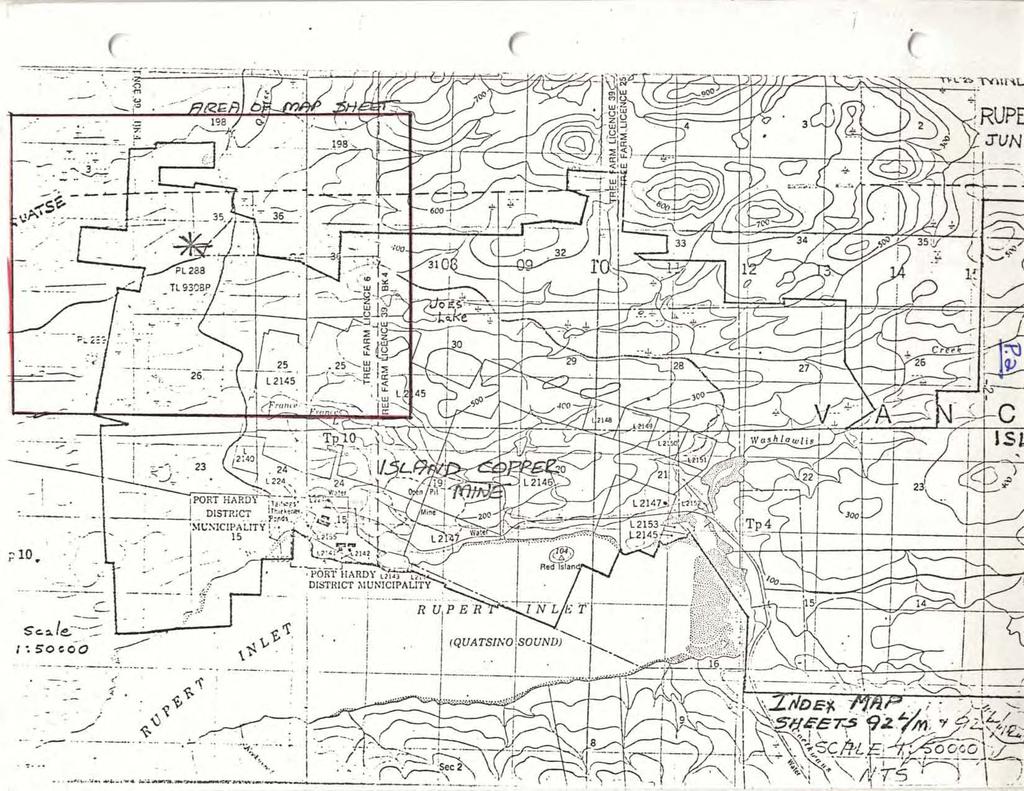
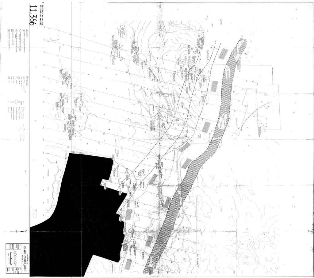
2 TABLE OF CONTENTS Page Introduction Location of Access History Physiography and Vegetation Location Map Geologic Program Structure APPENDIX A - Sta!ement of Costs APPENDIX B - Statement of Qua1 ifications MAP 1 - Front Pocket - Claim Map Showing Mapped Area MAP 2 - Back Pocket - Geology Map
3 INTRODUCTION This report will claim as assessment, the costs of compiling geologic data by means of a detailed mapping program just completed. A statement of costs, located in Appendix A, outlines the total costs of the project. LOCATION AND ACCESS The claim group, upon which the work was pebformed on, is logated in the0nanaimo Mining Division, with co-ordinates 'N, 'W. They are located on the NTS map sheet 92 L/12 and are located approximately four (4) kilometers northwest of. the Island Copper Pit and eight (8) kilometers southwest of Port Hardy, B.C., on Vancouver Is1 and. Access to the property is along the Coal Harbour Road from Port Hardy, a distance of ten (10) kilometers. On the property, logging roads provide excellent access into most of the area. The condition of all access roads is good. The claims upon which work was performed are owned by Utah Mines Ltd. and Gordon Mil bourne, of which Utah Mines Ltd. is the operator. The major block of claims have been held by the current owners since 1969, and fringe claims have been added since that time. PHYSIOGRAPHY AND VEGETATION Topography on the property consists of gently rolling hills that range from elevations of 350 meters to 510 meters. Vegetation is primarily large stands of fir-and cedar, many areas of which have been logged off.
4
5 GEOLOGIC PROGRAM The program performed, consisted of a detailed mapping program by G.L. Holland, a Geologist from the Utah Mines Ltd, Vancou.ver office. Mapping was performed on a scale of 1 inch = 400 feet or a metric equivalent of 1=4800. The program commenced on the 18th of April and was completed the 15th of June, Total area that was completed is approximately twel ve square kilometers. A total of six rock units were encountered in the area that was mapped. In sequence from oldest to youngest they incl ude: Karmutsen Volcanics; Quatsino 1 imestone; Parson Bay Sediments; Bonanza Volcanics; Hornblende Porphyry Intrusions; and Is1 and Intrusions. Lithologx: 1) Karmutsen Volcanics - andesite to basaltic composition. Primarily volcanic flows but minor pillowsare seen. The most noted texture in the Karmutsen is the plagioclase. amygdules, which are often up to 1 cm in size and often contain minor chlorite. Alteration noted, on the property, is a regional metamorphism of lower greenschist facies. 2) Quatsino Limestone - the limestone of this unit ranges from a dark grey, massive limestone to a light grey to white coloured sugary textured 1 imestone. Fracturing is generally moderately developed with calcite fill ing the fractures. Numerous petecypods and corals are found. Minor black chert nodules are present within the limestone. 3) Parson Bay Sediments - consists mainly of black limy s ha1 es with.numerous massive 1 imestone zones. The bl ac k shales exhibit strong bedding and colaur banding, with a1 ternating beds of black limy shales and a green, non-limy, mudstone. These beds range from a few millimeters, up to 20 centimeters in width. An average of 2-3% disseminated pyrite is present with values up to 5%. The shales bear pelecypodds and corals, most of which have been a1 teresf to calcite. At intrusive contacts, cherty sections are found with minor epidote rich skarn zones. Mapping failed to encounter any sul phide enrichment within these chert and skarn contact zones. The upper contact with the Bonanza volcanics shows no evidence of contact metamorphism, no chilled margins, or brecciation. There appears to be, an interfingering zone of the two rock types, the width of this zone is not determined. The lower contact with the Quatsino limestone was not found in outcrop but is be1 ieved to be gradational.
6 4) Bonanza Volcanics - this unit is dominated by lapill i tuffs, with minor amounts of volcanic breccia, crystal tuffs, and red cherts. The lapilli,tuffs are andesitic in composition and contain numerous clasts that range in size to about 2 mm. The cl asts are predominately feldspar with minor mafic and quartz clasts. The clast content rarely exceeds 15% of the rock. Graded.bedding is present, it9 minor amolunts,and is due mainly to alteration and clasts size. Alteration is the prominent feature of the tuffs, ranging from weak to intense, and varies over very short distances. The principal a1 ternation is sericite-chl orite with zones of sericite; serici te-chlorite-biotite; sericite-chlorite-epidote; and silicious-magnetite. The source of the a1 teration is very difficult to pinpoint as there is alot of overlap in alteration patterns of contact metamorphism, regional metamorphism and hydrothermal a1 teration. The sil icious-magneti te a1 teration is confined to the contacts of the hornblende porphyry dikes and appears due to hyd rothermal sol utions. Epidote is contained mainly along fractures and as mineral rep1 acement. The Volcanic breccia consists of fragments of Parson Bay shales and Bonanza lapilli tuffs in an andesitic matrix. The tuff fragments predominate and range up to 20 cm in size and much more rounded than the subangular tuff fragments. Minor bedding is present, defined by grain or fragment sizes. The crystal tuffs are defined by the presence of amygdules that are composed of feldspar, quartz and calcite. They are andesitic in composition and also contain the clasts present in the lapilli tuff. Minor zones of a pinkish to red chert are present in variaus places throughout the property, it is not determined whether - - these cherts are chemical precipitates or depositional. Pyrite is present throught most of the Bonanza volcanics in quantities up to 10-15%. Average grade is 1-3%. The pyrite is found as disseminations and on fractures within the rock. Chalcopyrite and molybdenum are found in various portions of the property. They occur in very minor amounts ( <.5%) and primarily along fractures. Magnetite is an alteration product and usually confined to zones of strong alteration, most often around the hornblende porphyry dyke.
7 5) Hornblende (feldspar) Porphyry - is andesitic in composition and contains 15% hornblende phenocrysts that range-up to 1 cm in size. Feldspar phenocrysts are present in most of the dyke outcrops and are generally 3-4 mm in size and up to 10% in content.. The dyke contains only minor pyrite and is often barren of su1 phides. It is believed that these dykes are feeder zones for upper Bonanza. volcanics that are not seen on the property. They are co-magmatic. 6) Island Intrusions - a stock of equigranular granodiorite is present in the north portion of the map sheet. This unit contains xenoliths of a slightly more mafic phase. The mineral assemblage is composed of biotite, fe1 dspar and quartz. No sul phi des are present. STRUCTURE Four promineat fragture girections are present on the property. They are 020 ; 060 ; 090 ; 130. These directions are present throughout most of the property and within all the rock units. This indicates a post depositional time period. No evidence. exists of majar faultigg or movement: Dykes are present along the 060 and 130 fracture directions. The other structural feature noted is theobedd6ng within the Parson Bay sediments. The beds trend 130 /-30 SW.
8 APPENDIX A STATEMENT OF COSTS
9 STATEMENT OF COSTS Wages - Permanent 40 $125.00/day 40 $105,00/day Field Supplies Total Costs Room and Board Gasoline Reproduction TOTAL COSTS:.
10 APPENDIX B STATEMENT OF QUALIFICATIONS
11 STATEMENT OF QUALIFICATIONS G.L. Holland - Geologist, graduated with a BSc from the University of British Columbia in Employed as a field assistant from 1973 to 1975 by Noranda Mines Ltd.; as a field assistant from 1976 to 1977 by Utah Mines Ltd; employed as a geologist from 1978 to present by Utah Mines Ltd., Vancouver Expl oration office.
12
13
14
15
The Cobalt Rainbow. Airborne geophysical maps show that a north trending aeromagnetic high suggests further undiscovered mineralisation.
 The Cobalt Rainbow The property is located on Greenstone Creek, approximately 4.8 kilometres south west of the creek mouth. The property is located about 24 km due west of Campbell River, in the east-central
Notes: Note. Township of GODSON Report NQ: 12. Diamond Dniiing. Hole NQ Footage Date. July/56. July/56. Aug/56. Aug/56. Claim NQ 487' K ' l-a
 Diamond Dniiing S2F«4NW«194 12 GODSON 010 Township of GODSON Report NQ: 12 Work performed by: KENNCO EXPLORATIONS (CANADA) LTD. Claim NQ Hole NQ Footage Date Note K 25434 l 487' July/56 l-a 48' July/56
2013 GEOLOGICAL ASSESSMENT REPORT SHERIDAN HILL PROPERTY
 2013 GEOLOGICAL ASSESSMENT REPORT ON THE SHERIDAN HILL PROPERTY NEW WESTMINSTER MINING DIVISION BRITISH COLUMBIA NTS 092G07 49 16 31 NORTH LATITUDE, 122 39 48 WEST LONGITUDE PREPARED FOR Sheridan Hill
NEW HAZELTON, OMINECA M.D.,
 PROSPECTING REPORT JUDI 1 TO 6 MINERAL CLAIMS NEW HAZELTON, OMINECA M.D., B.C. MAP 93M/4E, LAT. SS014'N, LONG. 127'33'W OWNED BY: A. L'ORSA ANTHONY L'ORSA Smithers, B.C. 21 February, 1981 TABLE OF CONTENTS
ON THE GEOLOGICAL AND MAGNETOMETER SURVEYS ON THE FANG NO. 1 TO 9 AND NO. 10 FRACTION MINERAL CLAIMS PROJECT 6051 N.T.S.
 AN INTERIM REPORT ON THE GEOLOGICAL AND MAGNETOMETER SURVEYS ON THE FANG NO. 1 TO 9 AND NO. 10 FRACTION MINERAL CLAIMS PROJECT 6051 LAT.~o'~~' LONG. 127'33' 8 MILES SOUTHWEST OF PORT ALICE, B.C. N.T.S.
lat ' N Long ' W
 305 7 ec1;, REPORT ON THE JERY CLAIMS OF POLA RESOURCES LTD. NTS 93L/16 0 0 lat. 54 45' N Long. 126 22' W BABIXE LAKE AREA OMINECA MINING DIVISION, B.C. PAUL PLICKA CONSULTING GEOLOGIST DECEMBER 30, 1981
1 FILMED 1. FILE NO:!..rsrru -* -. GRAND TWO CLAIM
 FILE NO:!..rsrru -* -. GRAND TWO CLAIM REPORT ON 1993 ASSESSMENT WORK GRAND TWO CLAIM REC. NO. 301849 NELSON MINING DIVISION NTS MAP SHEET 82F6/W 49 25'51" NORTH 117 18'08" WEST 1 FILMED 1 AUTHOR: R. Jordan,
GEOLOGY OF THE NICOLA GROUP BETWEEN MISSEZULA LAKE AND ALLISON LAKE
 GEOLOGY OF THE NICOLA GROUP BETWEEN MISSEZULA LAKE AND ALLISON LAKE (92H/15E. 10E1 By V. A. Preto INTRODUCTION Mapping was continued southward from the area covered in 1973 and an additional 55 square
Drill locations for the 2015 program are highlighted in the geology map below.
 2015 Exploration Program The exploration program plan at KSM for 2015 was designed to improve the understanding of block cave targets and support engineering/environmental aspects of development scenarios.
ASSESSMENT REPORT PROSPECTING PROGRAM ION/DIRTY JACK PROPERTY NELSON MINING DIVISION N.T.S. MAP SHEET 82F.023 UTM COORDINATES N E
 ASSESSMENT REPORT PROSPECTING PROGRAM ION/DIRTY JACK PROPERTY NELSON MINING DIVISION N.T.S. MAP SHEET 82F.023 UTM COORDINATES 5454800N - 0455235E Work Performed Summer 2007 OWNER >* ' Tom Kennedy >8 404-22
Compilation Report Hawke Hill South. Licence No M NTS 01N/06. Newfoundland and Labrador. Submitted by Gordon E. Cooper and Kevin P.
 Compilation Report 2010 Hawke Hill South Licence No. 017282M NTS 01N/06 Newfoundland and Labrador Submitted by Gordon E. Cooper and Kevin P. Ryan For Kevin P. Ryan (Licence holder) January, 2011 Work Year:
Regional geology map showing drill holes completed to date and hole RZDDH10 08 in progress, IP Chargeability anomalies hatched.
 Alteration Haloes Alteration facies in the Suarez-Misahuallí basin on the east side of the Rio Zarza gold project are complex, as they oerlap in time and space, are the result of weathering, diagenetic,
What is a Porphyry Copper Deposit?
 What is a Porphyry Copper Deposit? by David F. Briggs Over the last several years, many of you have probably heard the term porphyry copper and wondered what everyone is talking about. Porphyry copper
Technical Report. Geochemical Sampling West of Raymond Creek on Vancouver Island. Victoria Mining District 092C 15. UTM Co-ordinates N E
 Technical Report Geochemical Sampling West of Raymond Creek on Vancouver Island Victoria Mining District RECEIVED MINERAL TITLES BRANCH VANCOUVER, B.C. JAN 2 3 /i)13 L.l.g 092C 15 FILI NO. UTM Co-ordinates
UNION MINIERE EXPLORATIONS AND MINING CORPORATION LIMITED ASSESSMENT REPORT ON FITINAT MINERAL CLAIM. Alberni Mining Division Record No.
 M F )( UNION MINIERE EXPLORATIONS AND MINING CORPORATION LIMITED Suite 200, 4299 Canada Way, Burnaby, B.C. V5G 1 H4 Telephone (604) 437-9491 ASSESSMENT REPORT ON GEOCHEMICAL SOIL SURVEYS AND ROCKSAMPLING
1985 GEOLOGICAL AND GEOCHEMICAL REPORT
 COMINCO LTD. EXPLORATION NTS: 92G/9W/16W WESTERN DISTRICT ASSESSMENT REPORT 1985 GEOLOGICAL AND GEOCHEMICAL REPORT ON THE SLO 1 AND 2 MINERAL CLAIMS SLOQUET CREEK AREA - NEW WESTMINSTER MINING DIVISION
Metamorphism (means changed form
 Metamorphism (means changed form) is recrystallization without melting of a previously existing rock at depth in response to a change in the environment of temperature, pressure, and fluids. Common minerals
CEE 437 Lecture 10 Rock Classification. Thomas Doe
 CEE 437 Lecture 10 Rock Classification Thomas Doe Igneous Origins Intrusive Batholithic or plutonic: phaneritic Dikes or sills that chill rapidly: aphanitic Extrusive deposition as melt (lava) pyroclastic
GEOLOGY AND LITHOGEOCHEMISTRY OF THE CHILKO-TASEKO LAKES AREA* BY G.
 B Ministry of Energy, Mines and Petroleum Resources GEOLOGICAL BRANCH MINERAL RESOURCES DIVISION NOTES TO ACCOMPANY OPEN FILE - GEOLOGY AND LITHOGEOCHEMISTRY OF THE CHILKO-TASEKO LAKES AREA* BY G. P. McLAREN
Beekeeper Property The Geology South of Mint Lake. Cariboo Mining Division
 Beekeeper Property The Geology South of Mint Lake NTS: 93A/6 Cariboo Mining Division Claims: Beekeeper 1 #I2055 Beekeeper 2 #3892 Beekeeper 3 #7895 Beekeeper 4 #8503 Latitude: Longitude: 52 degrees 24
 16 Figure J. A fresh sample of Monzonite Porphyry is depicted including biotite hornblende and plagioclase phenocrysts, biotite is altering to chlorite and plagioclase is altering to clay. (magnification
GEOPHYSICAL SURVEY ASSESSMENT REPORT FOR THE RHONE GROUP ROCK CREEK, B.C. AREA GREENWOOD MINING DIVISION, B.C. N.T.S.
 I ACTION: -I FILE NO:. -..J GEOPHYSICAL SURVEY ASSESSMENT REPORT FOR THE RHONE GROUP ROCK CREEK, B.C. AREA GREENWOOD MINING DIVISION, B.C. N.T.S. 82E/3E AND 82E/6E LATITUDE NORTH: 49O 15' LONGITUDE WEST:
Chapter 4 Rocks & Igneous Rocks
 Chapter 4 Rocks & Igneous Rocks Rock Definition A naturally occurring consolidated mixture of one or more minerals e.g, marble, granite, sandstone, limestone Rock Definition Must naturally occur in nature,
GEOLOGICAL BRANCH ASSESSMENT REPORT
 GOLD FIELDS CANADIAN MINING, Ltd. PROPERTY FORGOLD SHEET 1 of 13 HOLE NO.FG-1 TWP Range Lot Claim No. FORGOLD-1 Coordinates Elevation 120 Core Size BQ Northing 27+. N Easting aa7.2 E Length (M) 167.03
DISCOVERY OF MINERALISED PORPHYRY & MAGNETITE-COPPER-GOLD AT KAMARANGAN
 MEDUSA MINING LIMITED ABN: 60 099 377 849 Unit 7, 11 Preston Street Como WA 6152 PO Box 860 Canning Bridge WA 6153 Telephone: +618-9367 0601 Facsimile: +618-9367 0602 Email: admin@medusamining.com.au Internet:
Geoloqv Assessment ReDort. Heather ProDertv. Victoria Mining Division NTS 92C/15, 16
 Litr NO: 03 04 ACTION: RO. FILE No: Geoloqv Assessment ReDort Heather ProDertv Victoria Mining Division NTS 92C/15, 16 48' 59' N Latitude 124' 30' W Longitude Owner: Minnova Inc. Operator: Minnova Inc.,
Chapter 10. Chapter Rocks and the Rock Cycle. Rocks. Section 1 Rocks and the Rock Cycle
 Chapter 10 Rocks 1 Chapter 10 Section 1 Rocks and the Rock Cycle 2 10.1 Rocks and the Rock Cycle Magma is the parent material for all rocks. Once the magma cools and hardens, many changes can occur. Geology:
FIRST YEAR ASSESSMENT REPORT PROSPECTING LICENCE 16512M MARYSTOWN AREA, BURIN PENINSULA NTS 1M/3
 FIRST YEAR ASSESSMENT REPORT OF PROSPECTING ON LICENCE 16512M MARYSTOWN AREA, BURIN PENINSULA NTS 1M/3 BY NATHANIEL NOEL MSc. FOR E. MICHELE NOEL MINERAL LICENCES: 16512 M WORK CONDUCTED: MID-SEPTEMBER
Ore deposits related to intermediate to felsic intrusions Porphyry Base Metal (Cu-Mo) Deposits. - GLY 361 Lecture 7
 Deposits. - GLY 361 Lecture 7") Ore deposits related to intermediate to felsic intrusions Porphyry Base Metal (Cu-Mo) Deposits - GLY 361 Lecture 7 Ore deposits related to intermediate to felsic intrusions Deposits associated with the
Ore deposits related to intermediate to felsic intrusions Porphyry Base Metal (Cu-Mo) Deposits - GLY 361 Lecture 7 Ore deposits related to intermediate to felsic intrusions Deposits associated with the
PROSPECTORS ASSISTANCE PROGRAM MINISTRY OF ENERGY AND MINES
 BRITISH COLUMBIA PROSPECTORS ASSISTANCE PROGRAM MINISTRY OF ENERGY AND MINES GEOLOGICAL SURVEY BRANCH PROGRAM YEAR: 1999/2000 REPORT #: PAP 99-l 6 NAME: KIM ANSCHETZ PROSPECTORS TlEPORT on the 99 LOUIS
Rich Saddle North Au-Cu-Ag Porphyry Expands by 275m Along Strike and 250m Down-Dip
 GT Gold Drills 281 Metres of 0.65 g/t Au, 0.38% Cu, 1.38 g/t Ag (1.24 g/t AuEq 1 ) Within 685 Metres 2 of 0.40 g/t Au, 0.26% Cu, 1.03 g/t Ag (0.81 g/t AuEq) in Step-out Hole TTD098 Rich Saddle North Au-Cu-Ag
Igneous Rock Classification, Processes and Identification Physical Geology GEOL 100
 Igneous Rock Classification, Processes and Identification Physical Geology GEOL 100 Ray Rector - Instructor Major Concepts 1) Igneous rocks form directly from the crystallization of a magma or lava 2)
Geology, Alteration and. Petrogenesis
 The Mutooroo Copper Deposit: Geology, Alteration and Petrogenesis Graham S. Teale Consultant t Andrew T. Price Havilah Resources NL The speaker would like to thank Havilah Resources NL for the opportunity
 19 00' N 70 20' W Loma La Cuaba volcanic edifice 70 00' W Pueblo Viejo District (location of Fig. 2) Loma Navisa volcanic edifice 69 40' W & S a m a n á B a y 0 10 20 Kilometers 18 50' N Guaimarote Hatillo
LAB 2 IDENTIFYING MATERIALS FOR MAKING SOILS: ROCK AND PARENT MATERIALS
 LAB 2 IDENTIFYING MATERIALS FOR MAKING SOILS: ROCK AND PARENT MATERIALS Learning outcomes The student is able to: 1. understand and identify rocks 2. understand and identify parent materials 3. recognize
CEE 437 Lecture 11 Rock Classification. Thomas Doe
 CEE 437 Lecture 11 Rock Classification Thomas Doe Translation of Mineral Properties to Rock Properties Comparison of mineral properties to rock properties Rocks have lower strength, especially tensile
: Other [ ] 309.0' 349.0' 359.0' 349.0'
![: Other [ ] 309.0' 349.0' 359.0' 349.0'](/thumbs/88/117547893.jpg ": Other [ ] 309.0' 349.0' 359.0' 349.0'") 2F68NW8ee8 26 KAWASHEGAMUK LAKE 0 DIAMOND DRILLING AREA: KAWASHEGAMUK LAKE REPORT NO: 26 WORK PERFORMED FOR: International Platinum Corporation RECORDED HOLDER: Same as above [xx] : Other [ ] Claim Hole
2F68NW8ee8 26 KAWASHEGAMUK LAKE 0 DIAMOND DRILLING AREA: KAWASHEGAMUK LAKE REPORT NO: 26 WORK PERFORMED FOR: International Platinum Corporation RECORDED HOLDER: Same as above [xx] : Other [ ] Claim Hole
A Prospecting Report on the Leo d Or Mineral Claims
 A Prospecting Report on the Leo d Or Mineral Claims Hnvilah Gold Mines Ltd. John Devlin Ande Rychter Leo d Or Claims 2202 C63 NTS, 32 L/7NNippkish 1264 W W, 508) 23$J o f Owner: M.S. Madnri /nay 25, 1987
TECK EXPLORATION LTD DIAMOND DRILL LOG
 Hole ST97-1 Sheet 1 of 8 42D9NW24 2.19129 PIC TECK EXPLORATION LTD. 1 DIAMOND DRILL LOG Job 163 H.T.S. 42 D/9 Property wnship. Claim No. Stenlund Pic wnship 18629/18622 Location: Line 923E.. Station 77N
on the SALAL CREEK MOLYBDENUM PROPERTY, SALAL CREEK, B.C. LILLOOET MINING DIVISION, BRITISH COLUMBIA
 on the J PLUG 9-12, PLUG 19-24, BAT 10-14, BAT 15 Fr., BAT 16 Fr. MINERAL CLAIMS, SALAL CREEK MOLYBDENUM PROPERTY, SALAL CREEK, B.C. LILLOOET MINING DIVISION, BRITISH COLUMBIA N.T.S. 92 J 14 LATITUDE 50
APPENDIX 2 Table 2. Sample descriptions
 Table 2. descriptions 225 Felsic gneiss, fine-grained and very light-gray. From the upper part of the lower of the two layers, which connect. 226 Amphibolite, even-grained, fine-grained, medium-gray, little
HOWE COPPER MINE PROJECT HIGH GRADE Cu-Ag with Au
 HOWE COPPER MINE PROJECT HIGH GRADE Cu-Ag with Au The Howe Copper Mine property is located approximately 55 kilometres northwest of Vancouver, BC. It is situated at 1431 metres elevation on the eastern
-/ttr- Hor. - ill 86 A. II II II 111 li 111 DIAMOND DRILL CORE LOGGING SHEETS 9. Ol^**a. ILJJ If ^ /^jjg^jrs c DESCRIPTION ^~"~ ~.
 DIAMOND DRILL CORE LOGGING SHEETS 9 86 A PROPERTY: Solarus HOLE NO.: KL-04-01 LOCATION: Longlac LENGTH: 354.8 m PROJECT NUMBER: NORTHING: 1+40N ELEVATION: 0 UTM northing: 5514255 COLLAR ORIENTATION (AZIMUTH
CONTINUING INVESTIGATION OF THE RANCH CLAIMS BONANZA LAKE AREA, ISLAND BRITISH COLUMBIA
 CONTINUING INVESTIGATION OF THE RANCH CLAIMS BONANZA LAKE AREA, VANCOUVER ISLAND BRITISH COLUMBIA OMYA (CALIFORNIA) Howard Brown Geologist INC. /- TOPIC TABLE OF CONTENTS PAGE SUMMARY INTRODUCTION PROPERTY
Block: Igneous Rocks. From this list, select the terms which answer the following questions.
 Geology 12 Name: Mix and Match: Igneous Rocks Refer to the following list. Block: porphyritic volatiles mafic glassy magma mixing concordant discontinuous reaction series igneous vesicular partial melting
MUDDY LAKE PROSPECT (104WlW)
") MUDDY LAKE PROSPECT (104WlW) BY T. G. Schroeter INTRODUCTION The Muddy Lake gold property consists primarily of the Bear and Totem group of claims and is located 137 kilometres west of Deasc! Lake at latitude
MUDDY LAKE PROSPECT (104WlW) BY T. G. Schroeter INTRODUCTION The Muddy Lake gold property consists primarily of the Bear and Totem group of claims and is located 137 kilometres west of Deasc! Lake at latitude
Geochemical exploration on the Tareek Darreh Gold deposit, north of Torbat-e Jaam, east Iran
 Geochemical exploration on the Tareek Darreh Gold deposit, north of Torbat-e Jaam, east Iran Kourosh Shabani, M.Sc. Student of Economic Geology, Islamic Azad University, Science and Research Branch, Tehran,
ASSESSMENT REPORT GEOLOGICAL BRANCH. 50' 23 'North. GEOLOGICAL and GEOCHEMICAL SURVEYS ON THE. PUTNAM PROPERTY (Putnam Mineral Claim)
") GEOLOGICAL and GEOCHEMICAL SURVEYS ON THE PUTNAM PROPERTY (Putnam Mineral Claim) VERNON MINING DIVISION, B.C. GEOLOGICAL BRANCH ASSESSMENT REPORT NTS : Latitude: 82L17W 50' 23 'North LOCATION, ACCESS,
GEOLOGICAL and GEOCHEMICAL SURVEYS ON THE PUTNAM PROPERTY (Putnam Mineral Claim) VERNON MINING DIVISION, B.C. GEOLOGICAL BRANCH ASSESSMENT REPORT NTS : Latitude: 82L17W 50' 23 'North LOCATION, ACCESS,
CAMBRIAN INTRUSION-RELATED COPPER MINERALISATION AT THE THOMAS CREEK PROSPECT, SOUTHWESTERN TASMANIA
 CAMBRIAN INTRUSION-RELATED COPPER MINERALISATION AT THE THOMAS CREEK PROSPECT, SOUTHWESTERN TASMANIA UN I VF.RS TTY OF TASMANIA By Robert Reid (B.Sc. Hons) A thesis submitted in partial fulfillment of
Technical Report. Geochemical Sampling of Raymond Creek on Vancouver Island. Victoria Mining District 092C 15. UTM Co-ordinates N E
 Technical Report Geochemical Sampling of Raymond Creek on Vancouver Island Victoria Mining District 092C 15 UTM Co-ordinates 5414044N 389836E Owner of Claims is Dean Arbic(133434) Report Written by Dean
Mineral Exploration Research Centre, Harquail School of Earth Sciences, Laurentian University, Sudbury, Ontario, P3E 2C6, Canada
 Volcanic stratigraphy and intrusions in the Renault Dufresnoy and Duprat Montbray formations: implications for metal endowment in the lower Blake River group, Rouyn-Noranda, Quebec Jonathan Sutton, Harold
Page 1. Name:
 Name: 1) What is the approximate density of a mineral with a mass of 262.2 grams that displaces 46 cubic centimeters of water? A) 6.1 g/cm 3 C) 1.8 g/cm 3 B) 5.7 g/cm 3 D) 12.2 g/cm 3 2) In which two Earth
Rocks. 3.1 The Rock Cycle. 3.1 The Rock Cycle. 3.1 The Rock Cycle. The Rock Cycle. I. Rocks
 Rocks Tarbuck Lutgens 3.1 The Rock Cycle 3.1 The Rock Cycle I. Rocks Rocks are any solid mass of mineral or mineral-like matter occurring naturally as part of our planet. Types of Rocks 1. Igneous rock
ASSESSMENT REPORT ON THE PEAVINE PROJECT. DGW & Associates # Alberni Street, Vancouver, British Columbia, V6E 4V2
 ASSESSMENT REPORT ON THE PEAVINE PROJECT KAMLOOPS MINING DIVISION BRITISH COLUMBIA NTS 082M 12 Latitude 51 36' 19.0"North -- Longitude --119 47' 27.0"West UTM Zone 11, NAD 83 5720827N 306744E Prepared
SECOND DRILL HOLE IHAD2 INTERSECTS MINERALIZED TAPLEY HILL FORMATION AND MINERALIZED BASEMENT IRON FORMATION
 Suite 304, 22 St Kilda Road St Kilda Vic 3182 Ph: +61 3 9692 7222; Fax: +61 3 9529 8057 For Immediate Release 14 th September 2007 SECOND DRILL HOLE IHAD2 INTERSECTS MINERALIZED TAPLEY HILL FORMATION AND
GEOLOGICAL MAPPING REPORT ON THE ASH MINERAL CLAIM OSOYOOS MINING DIVISION ASHNOLA RIVER MAP SHEET NTS M092,H019 MCBRIDE CREEK AREA, ASHNOLA RIVER,
 GEOLOGICAL MAPPING REPORT ON THE ASH MINERAL CLAIM OSOYOOS MINING DIVISION ASHNOLA RIVER MAP SHEET NTS M092,H019 LATITUDE 49 o O6, LONGITUDE 120 o 22 MCBRIDE CREEK AREA, ASHNOLA RIVER, KEREMEOS, B.C. CANADA
ROCK CLASSIFICATION AND IDENTIFICATION
 Name: Miramar College Grade: GEOL 101 - Physical Geology Laboratory SEDIMENTARY ROCK CLASSIFICATION AND IDENTIFICATION PRELAB SECTION To be completed before labs starts: I. Introduction & Purpose: The
SUPPLEMENT DR1: SAMPLE DESCRIPTION
 GSA DATA REPOSITORY 2013218 Yunxing Xue et al. SUPPLEMENT DR1: SAMPLE DESCRIPTION Three gold deposits from the EGST and one from Abitibi belt have been selected for this study. Bellerophon, Wallaby, and
Prentice Hall EARTH SCIENCE
 Prentice Hall EARTH SCIENCE Tarbuck Lutgens Chapter 3 Rocks 3.1 The Rock Cycle Rocks Rocks are any solid mass of mineral or mineral-like matter occurring naturally as part of our planet. Types of Rocks
Date Submitted: June General Nature of Report: Examination of Placer Samples
 General Nature of Report: Examination of Placer Samples Claim: Gold Channel, Record Number 3775!8 1 (Gold Channel Placer Property) Mining Division: Cariboo NTS 093 G 09 W and E Latitude 520 23 N' Longitude1210
3. GEOLOGY. 3.1 Introduction. 3.2 Results and Discussion Regional Geology Surficial Geology Mine Study Area
 3. GEOLOGY 3.1 Introduction This chapter discusses the baseline study of the geology and mineralization characteristics of the mine study area. The study consolidates existing geological data and exploration
COMPOSITIONAL TERMS: FELSIC : light colored INTERMEDIATE : medium shades MAFIC : dark colored ULTRAMAFIC : rare (composition of the mantle)
") GEOLOGY 306 Laboratory NAME: Instructor: TERRY J. BOROUGHS SECTION: Common Rocks (Chapter 2) For this assignment, you will require: a streak plate, glass plate, magnet, dilute hydrochloric (HCl) acid,
GEOLOGY 306 Laboratory NAME: Instructor: TERRY J. BOROUGHS SECTION: Common Rocks (Chapter 2) For this assignment, you will require: a streak plate, glass plate, magnet, dilute hydrochloric (HCl) acid,
The MAPLE BAY PROJECT Copper Silver - Gold
 The MAPLE BAY PROJECT Copper Silver - Gold Good grade and tonnage potential within close proximity to Tidewater The Maple Bay Copper Silver Gold Project covers highly favourable geological host rocks of
PHYSICAL WORK REPORT. the BAY CLAIMS. Omineca Mining Division Smithers, British Columbia N.T.S. 93E 13E/W
 PHYSICAL WORK REPORT the BAY CLAIMS Omineca Mining Division Smithers, British Columbia a N.T.S. 93E 13E/W LATITUDE: 53 57 00 N I LONGITUDE: 127 45 OO W for Home Ventures Ltd. 1201-675 West Hastings Street
TOPOGRAPHICAL SURVEY REPORT ON THE GREENDROP PROPERTY NEAR CHILLIWACK, B.C. 92-H-3/W
 TOPOGRAPHICAL SURVEY REPORT ON THE GREENDROP PROPERTY NEW WESTMINSTER M.D. NEAR CHILLIWACK, B.C. 92-H-3/W Location: The central pap of the claims is located at coordinates 49 08'N, latitude by 121 26'W,
Sediments and Sedimentary Rocks
 Sediments and Sedimentary Rocks (Shaping Earth s Surface, Part 2) Science 330 Summer 2005 What is a sedimentary rock? Products of mechanical and chemical weathering Account for about 5 percent of Earth
LOS AZULES April 2018
 April 2018 lies along the southern extensions of the highly productive Paleocene Mineral Belt in northern Chile that contains numerous important copper, gold and silver mines and projects, and to the south
Work performed by: RALPH E. ALLERSTON (NEWMONT)
") 41Pt4NE8843 24 SOTHMAN 010 Diamond Drilling Township OF SOTHMAN Report NQ; Work performed by: RALPH E. ALLERSTON (NEWMONT) Claim N9 Hole NO Footage Date Note L. 332897 L. 332898 H-l-73 H-2-73 613' 587'
41Pt4NE8843 24 SOTHMAN 010 Diamond Drilling Township OF SOTHMAN Report NQ; Work performed by: RALPH E. ALLERSTON (NEWMONT) Claim N9 Hole NO Footage Date Note L. 332897 L. 332898 H-l-73 H-2-73 613' 587'
Name Class Date. In your textbook, read about the nature of igneous rocks. Use each of the terms below just once to complete the following statements.
 CHAPTER 5 Igneous Rocks SECTION 5.1 What are igneous rocks? In your textbook, read about the nature of igneous rocks. Use each of the terms below just once to complete the following statements. basaltic
Geology 12 FINAL EXAM PREP. Possible Written Response Exam Questions
 Geology 12 FINAL EXAM PREP Possible Written Response Exam Questions Use this study guide to prepare for the written response portion of the final exam. Name FINAL EXAM - POSSIBLE WRITTEN RESPONSE QUESTIONS
QQQ-4 QQQ-3. Apr/78 Apr/78. Diamond Drilling. Claim N9 Hole NO Footage Date Note P ,0' P ' (2) Notes: (1) #132-78
 Notes: (1) #132-78") Diamond Drilling 42B01SE0018 22 PENHORWOOD 010 Township of PENHORWOOD Report NO 22 Work performed by: Geophysical Engineering Limited Claim N9 Hole NO Footage Date Note P 504953 P 504938 QQQ-4 QQQ-3 220,0'
Diamond Drilling 42B01SE0018 22 PENHORWOOD 010 Township of PENHORWOOD Report NO 22 Work performed by: Geophysical Engineering Limited Claim N9 Hole NO Footage Date Note P 504953 P 504938 QQQ-4 QQQ-3 220,0'
Evaluating the Intrusion-Related Model for the Archean Low-Grade, High- Tonnage Côté Gold Au(-Cu) Deposit
 Deposit") Evaluating the Intrusion-Related Model for the Archean Low-Grade, High- Tonnage Côté Gold Au(-Cu) Deposit L.R. Katz, D.J. Kontak, Laurentian University, B. Dubé, V. McNicoll, Geological Survey of Canada
Evaluating the Intrusion-Related Model for the Archean Low-Grade, High- Tonnage Côté Gold Au(-Cu) Deposit L.R. Katz, D.J. Kontak, Laurentian University, B. Dubé, V. McNicoll, Geological Survey of Canada
Summary of Rover Metals Geologic Mapping Program at the Up Town Gold Project, Northwest Territories
 October 13, 2017 Summary of Rover Metals Geologic Mapping Program at the Up Town Gold Project, Northwest Territories Vancouver, British Columbia, Canada - Rover Metals Corp., Rover, is pleased to provide
of the PRISM RESOURCES LTD. JAMES S. CHRISTIE, Ph.D. N 0. GEOLOGY AND ROCK GEOCHEMISTRY ASHNOLA - MCBRIDE CREEK PROPERTY of
 GEOLOGY AND ROCK GEOCHEMISTRY of the ASHNOLA - MCBRIDE CREEK PROPERTY of PRISM RESOURCES LTD. ASH - NOLA - CAT - CLAIMS 92 H/1W JAMES S. CHRISTIE, Ph.D. April 4, 1977 MINERAL RESOURCES BRANCH ASSESSMENT
ASSESSMENT REPORT MAGNETOMETER SURVEY GOLDEN ROD, GOLDEN ROD #2. Long.: General Delivery, Vananda, B. C.
 ASSESSMENT REPORT MAGNETOMETER SURVEY GOLDEN ROD, GOLDEN ROD #2 t=/ NTS 92~110w Lat.: Long.: 49O 44' N 124O 34' W Owner: E. Johanson General Delivery, Vananda, B. C. Operator: Rhyolite Resources I nc.
Igneous and Metamorphic Rock Forming Minerals. Department of Geology Mr. Victor Tibane SGM 210_2013
 Igneous and Metamorphic Rock Forming Minerals Department of Geology Mr. Victor Tibane 1 SGM 210_2013 Grotzinger Jordan Understanding Earth Sixth Edition Chapter 4: IGNEOUS ROCKS Solids from Melts 2011
NOA ASSESSMENT HARRIS QUARRY MENDOCINO COUNTY, CALIFORNIA TABLE OF CONTENTS
 NOA ASSESSMENT HARRIS QUARRY MENDOCINO COUNTY, CALIFORNIA TABLE OF CONTENTS Introduction... 1 Scope of Services... 1 Project Location and Description... 1 Geologic Setting... 1 Regional Geology... 1 Site
GEOLOGICAL FEATURES OF THE BADGER SPRINGS TRAIL FOR HIKERS Rev. 3,
 GEOLOGICAL FEATURES OF THE BADGER SPRINGS TRAIL FOR HIKERS Rev. 3, 12-3-02 http://ensayoes.com/docs/176/index-2111121.html Trail location The Badger Springs trail is just a short distance North of the
zccaw- d 4, I SUB- RECORDER 1 GEOLOGICAL IBIRANC)~ SEP ASSESSMENT REPORT FRENO: ACTION: 2[-;tc,u,eAAA RECEIVED M.R.#... $... VANCOUVER, B.C.
~ SEP ASSESSMENT REPORT FRENO: ACTION: 2[-;tc,u,eAAA RECEIVED M.R.#... $... VANCOUVER, B.C.") c ON THE LOGMI: /+dq(. m. BONBON MINERAL CLAIM ' ACTION: 2[-;tc,u,eAAA -- FRENO: h zccaw- d 4, FOR LUCIA SPECOGNA I SUB- RECORDER 1 RECEIVED SEP 25 1990 M.R.#... $... VANCOUVER, B.C. i BY MARINO SPECOGNA
c ON THE LOGMI: /+dq(. m. BONBON MINERAL CLAIM ' ACTION: 2[-;tc,u,eAAA -- FRENO: h zccaw- d 4, FOR LUCIA SPECOGNA I SUB- RECORDER 1 RECEIVED SEP 25 1990 M.R.#... $... VANCOUVER, B.C. i BY MARINO SPECOGNA
LINGIG PORPHYRY COPPER DISCOVERY
 MEDUSA MINING LIMITED ABN: 60 099 377 849 Unit 7, 11 Preston Street Como WA 6152 PO Box 860 Canning Bridge WA 6153 Telephone: 618-9367 0601 Facsimile: 618-9367 0602 Email: admin@medusamining.com.au Internet:
As compaction and cementation of these sediments eventually occur, which area will become siltstone? A) A B) B C) C D) D
 A B) B C) C D) D") 1. A student obtains a cup of quartz sand from a beach. A saltwater solution is poured into the sand and allowed to evaporate. The mineral residue from the saltwater solution cements the sand grains together,
1. A student obtains a cup of quartz sand from a beach. A saltwater solution is poured into the sand and allowed to evaporate. The mineral residue from the saltwater solution cements the sand grains together,
TASEKO LAKES AREA (920) By W. J. McMillan. (920/3Wl
 By W. J. McMillan. (920/3Wl") TASEKO LAKES AREA (920) By W. J. McMillan GRANITE CREEK PROPERTY (920/3Wl The Granite Creek property was studied and diamond drilled by Quintana Minerals Corporation in 1976. Work was directed by K. W.
TASEKO LAKES AREA (920) By W. J. McMillan GRANITE CREEK PROPERTY (920/3Wl The Granite Creek property was studied and diamond drilled by Quintana Minerals Corporation in 1976. Work was directed by K. W.
Review - Unit 2 - Rocks and Minerals
 Review - Unit 2 - Rocks and Minerals Base your answers to questions 1 and 2 on the diagram below, which shows the results of three different physical tests, A, B, and C, that were performed on a mineral.
THIS IS A NEW SPECIFICATION
 THIS IS A NEW SPECIFICATION ADVANCED SUBSIDIARY GCE GEOLOGY Rocks Processes and Products F792 * OCE / 11038 * Candidates answer on the question paper OCR Supplied Materials: None Other Materials Required:
EMPIRE DEVELOPMENT COMPANY LIMITED
 EMPIRE DEVELOPMENT COMPANY LIMITED 1017-736 Granville Street Vancouver 2, B.C. January 17, 1966 Chief Gold Commissioner, Department of Mines & Petroleum Reso,urces, Victoria, B.C. Dear Sir: The field work
Foundation Unit A.M. THURSDAY, 20 May hour
 Candidate Name Centre Number 2 Candidate Number GCE AS/A level 1211/01 GEOLOGY - GL1 Foundation Unit A.M. THURSDAY, 20 May 2010 1 hour Question 1 Question 2. 1211 01 01 Question 3 Question 4 Total 60 ADDITIONAL
Some Slides Lack Permission for Reproduction. These Slides must be deleted before posting as html or pdf! Metamorphic Rocks. GEOL 101 Lecture
 Some Slides Lack Permission for Reproduction. These Slides must be deleted before posting as html or pdf! Metamorphic Rocks GEOL 101 Lecture 9 2006 JS Kite WVU What is story behind this rock? Test 1 Results
Chapter 7 Metamorphism, Metamorphic Rocks, and Hydrothermal Rocks
 Chapter 7 Metamorphism, Metamorphic Rocks, and Hydrothermal Rocks Copyright The McGraw-Hill Companies, Inc. Permission required for reproduction or display. Metamorphism What happens to rocks that are
New gold discovery in the Paleoproterozoic Mauken greenstone belt
 New gold discovery in the Paleoproterozoic Mauken greenstone belt Mauken greenstone belt The Paleoproterozoic Mauken greenstone belt is situated in an unexplored and untested terrain in Northern Norway.
Answers. Rocks. Year 8 Science Chapter 8
 Answers Rocks Year 8 Science Chapter 8 p171 1 Rocks are made up of minerals such as quartz, feldspars, micas, and calcite. Different rocks are made up of different combinations of minerals. 2 Igneous,
7 MILES WEST OF PORT HARDY, B.C.
 GEOPHYSICAL REPORT VERTICAL INTENSITY MAGNETOMEER SURVEY ON LUK CLAIMS, 7 MILES WEST OF PORT HARDY, B.C. 50' 127O SE BY R. E. SHIELDS UNDER SUPERVISION OF J. R. BILLINGSLEY FOR SECOND0 MINING LTD. (N.
1. Base your answer to the following question on on the photographs and news article below. Old Man s Loss Felt in New Hampshire
 UNIT 3 EXAM ROCKS AND MINERALS NAME: BLOCK: DATE: 1. Base your answer to the following question on on the photographs and news article below. Old Man s Loss Felt in New Hampshire FRANCONIA, N.H. Crowds
GLY 155 Introduction to Physical Geology, W. Altermann. Grotzinger Jordan. Understanding Earth. Sixth Edition
 Grotzinger Jordan Understanding Earth Sixth Edition Chapter 4: IGNEOUS ROCKS Solids from Melts 2011 by W. H. Freeman and Company Chapter 4: Igneous Rocks: Solids from Melts 1 About Igneous Rocks Igneous
Sedimentary Rocks. Origin, Properties and Identification. Geology Laboratory GEOL 101 Lab Ray Rector - Instructor
 Sedimentary Rocks Origin, Properties and Identification Geology Laboratory GEOL 101 Lab Ray Rector - Instructor Sedimentary Rock Origin and Identification Lab Pre-Lab Internet Link Resources 1) http://www.rockhounds.com/rockshop/rockkey/index.html
Sedimentary Environments Chapter 8
 Sedimentary Environments Chapter 8 Does not contain complete lecture notes. To be used to help organize lecture notes and home/test studies. What is a sedimentary rock? Sedimentary rocks are products of
Alteration and Mineralization at Daralu Porphyry Copper Deposit, South of Kerman, Southeast Iran
 Alteration and Mineralization at Daralu Porphyry Copper Deposit, South of Kerman, Southeast Iran Mosayeb Salehian* and Majid Ghaderi Department of Geology, Tarbiat Modares University, Tehran, Iran *Email
to represent sediments deposited through a series of marine transgressive
 i Hydrogeol ogy of Sal tsprinq s1 and Two main assemblages of rocks directly underly Saltspring sland. The Napajmo Group of Upper Cretaceous aqe comprising sedimentary rocks lies in th, brthern half and
Tameapa Regional Geology
 Tameapa Project 1 Tameapa Regional Geology History San Francisco Mines of Mexico Ltd. (San Francisco), which completed an exploration program, including six drill holes (1,157 m) between 1956 and 1959.
1. Which mineral is mined for its iron content? A) hematite B) fluorite C) galena D) talc
 hematite B) fluorite C) galena D) talc") 1. Which mineral is mined for its iron content? A) hematite B) fluorite C) galena D) talc 2. Which material is made mostly of the mineral quartz? A) sulfuric acid B) pencil lead C) plaster of paris D)
1. Which mineral is mined for its iron content? A) hematite B) fluorite C) galena D) talc 2. Which material is made mostly of the mineral quartz? A) sulfuric acid B) pencil lead C) plaster of paris D)
Serengeti Resources Inc GEOCHEMICAL REPORT ON THE SHADOW PROPERTY a.
 Serengeti Resources Inc. 2004 GEOCHEMICAL REPORT ON THE SHADOW PROPERTY a. Located in the Johanson Lake Area Omenica Mining Division NTS 94D/9 6 degrees and 32 minutes North Latitude 126 degrees and 2