REPORT ON GEOLOGICAL, GEOCHEMICAL AND GEOPHYSICAL SURVEY CONDUCTED ON THE LP 13,14,15 MINERAL CLAIMS VERNON MINING DIVISON BRITISH COLUMBIA
|
|
|
- Lucinda Shelton
- 5 years ago
- Views:
Transcription
1 REPORT ON GEOLOGICAL, GEOCHEMICAL AND GEOPHYSICAL SURVEY CONDUCTED ON THE LP 13,14,15 MINERAL CLAIMS VERNON MINING DIVISON BRITISH COLUMBIA N.T.S. 82E/15E Longitude ' N. Latitude ' W. Owners of the Claims: Mohawk Oil Co. Ltd. Operator: Mohawk Oil Co. Ltd. Autbor: B. Callaghan, B. Sc. Dated: August 15, 1984
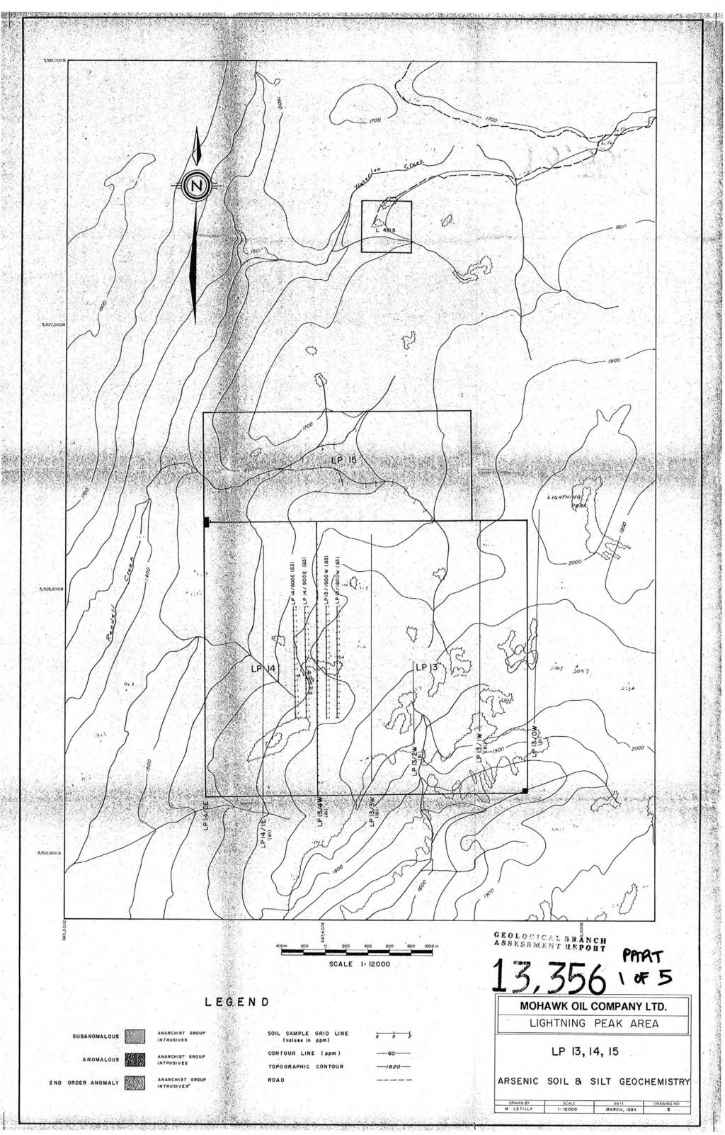
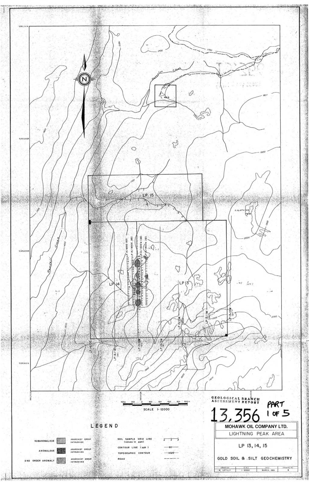
2 - TABLE OF CONTENTS Introduction Summary Location and Access Physiography Mining Property General Geology Structural Geology Economic Geology Geochemistry Interpretation of Geochemistry Geophysics Conclusions and Recommendations Author's Qualifications Bibliography Page APPENDICES Appendix I Iternized Cost Statement Appendix I1 Magnetic Surveys - Instrumentation and Theory Appendix I11 Mag. Corrections MAPS AND TABLES Location Map Figure 1 Claims Map Figure 2 Geology Map Drawing No. 1 Soil Geochemistry Maps Drawings No. 2 to 9 Magnetic Map Figure 3 Rock Sample Assays Table I Geochemistry Parameters Table I1 In Pocket I I I1
3 INTRODUCTION Exploration work on LP 13, 14 and 15, Mineral Claims during the 1983 field season included follow-up geology, geochemistry and geophysics. Two helicopter days were spent on August 22nd and 23rd, in an effort to determine the source of gold geochemical anomalies determined from the 1981 reconnaissance programme conducted over the claims. Reference for a description of the 1981 programme history and results should be made to l'geological and Geochemical Report on the Lightning Peak Mineral Claim LP 2-19, 20F, 23F,24F, 25", Vernon Mining Division. Geological mapping was done in conjunction with the goechemical follow-up survey and magnetic survey.
4 SUMMARY Grassroots exploration in 1981 revealed anomalously high concentrations of gold from the geochemical soil sampling programme on Mineral Claims LP 13 and LP 14. A 1983 follow-up soil geochemical sampling programme was designed to define additional gold anomalies to those identified from Although a finite source of these anomalies was not determined, these areas have potential for economic mineralization and warrant further investigation. A programme of further geochemical sampling, prospecting and geological mapping is recommended followed up with trenching, to explore the potential for possible skarn-type mineralization as well as gold, silver mineralization in quartz associated with the intrusive rocks.
5 LOCATION AND ACCESS The LP 13, 14, and 15 claims are located within the Monashee Mountains of Southern British Columbia, approximately 3 kilometres west and south of Lightning Peak, map sheet N.T.S. 82E/15E, latitude 'N and longitude 'N. I Nearest access to the claims is via the Lightning Peak road which joins Highway 6 approximately 110 kilometres southwest of Vernon. Access can also be gained to Lightning Peak via a newly established extension of the K-50 logging access road which leaves the Kettle River logging road at 62 kilometre. The Kettle River road intersects Highway 6 at Spruce Grove about 52 kilometres southeast of Lumby. The claim block is situated to the west, 2 kilometres from the end of the access road that passes south of Lightning Peak, approximately 33 kilometres from Highway 6.
6 MOHAWK OIL Co. LTD. LOCATION MAP
7 PHYSIOGRAPHY Elevations range between 1600 and 1900 metres. The west and north portions of the claim are drained by westerly flowing tributaries into Rendell Creek. I Best exposures of outcrop occur along the creek bottoms and sharply rising ridges. Talus slopes predominate along the western slopes of exposed outcrop areas in the west central area of the claim block. exposed as outcrop. Overall, approximately 25% of the claim area is Forested areas include stands of Spruce, Jack Pine, Balsam, Alder and Poplar that are broken by clear areas of alpine meadows surrounded by outcrop exposures at higher elevations.
8 - PROPERTY The LP 13, 14, and 15 claims are currently held by the owners, Mohawk Oil Co. Ltd. and include: Name Claim I No. Units Record No. Month of Record March March March
9 4'iW I. --..I*-. 4.# I- 1 r MOHAWK OIL CO. LTD. SCALE ', MCTRLS CLAIMS MAP DRAWN BY 1 DATE ]DRAWING NO. - BC i APRIL, 84 i FIG 2..
10 - GENERAL GEOLOGY Geological mapping during the 1981 field season was done at a scale of 1: Mapping control included line mapping between identifiable points and the use of B.C. Government air photos at q scale of 1: This preliminary mapping was followed up in 1983 by detailed line mapping in the areas of higher geochemical gold values (Drawing No. 1). The general geology of the area is described by Cairnes (1930) and Little (1957). The Permian (?) Anarchist Group rocks form a roof pendant in the Lightning Peak area and consist of greenstone, greywacke, tuffs, limestone and paragneiss. The roof pendant is surrounded and intruded by Cretaceous (?) Nelson Intrusions. The Anarchist Group rocks host westerly striking silver, lead, zinc mineralization in the nearby Waterloo Mine which produced tonnages of high grade silver ore. Intrusive rocks in the northern and eastern portions of the claims are primarily granodiorite. Coarse grained, light grey to slightly pink diorite occurs in the south western portion of the 1983 grid area and is distinguished by large anhedral crystals of pyroxene with minor fresh biotite and accessory magnetitie. The rest of the rock is composed of approximately 60% plagioclase which exhibits some local epidote alteration. The intrusives are in contact with northeast trending Anarchist Group limestone and andesitic lava, tuffs and tuffaceous sediments. The banded limestone is generally fine to medium grained and varies in colour from white, grey, green to tan. Anarchist metavolcanics in the southeast portion of LP 13 and LP 14 consist of tuffs thought to be altered limy tuffs by Cairnes (1930) which are characterized by a dark green-grey, fine grained ground mass containing abundant hornblende porphyroblasts. Mineralization in these metavolcanic rocks consists of fine grained disseminated pyrite and hair-line fracture in fillings of pyrite.
11 STRUCTURALGEOLOGY The contact between Nelson Intrusives and northeast trending Anarchist Croup rocks has been interpretated using aerial photography and airborne magnetic data in conjunction with the geological mapping. The contact zone is most noticeable in the centre of mineral claim LP 13 and the southeast corner of mineral claim LP 14. Other interpretated structural fractures include eastwest faulting in the centre of LP 15 and a northwest trending fault in the centre of mineral claim LP 14. Anomalous soil geochemical values in silver, zinc and lead occur on the southern end of lines 8+00E and 9+00E coincident with this fault. ECONOMIC GEOLOGY Pyrite mineralization hosted in quartz, sericite altered intrusives, on lines 1800W and 9+00N, occurred as fine to coarse grained disseminations with chlorite and pyrolusite occurring along fracture surfaces. Minor amounts of vuggy quartz float were also discovered in this area. A gold value of 2Oppb occurred approximately 75 metres to the north of this mineralization. Representative rock geochem. samples include (see Table I). One grab sample, 4296, recorded values of 5ppb gold, 1.8ppm silver, 7lOppm zinc, and 185ppm arsenic. These findings indicate that the intrusive rocks in this area may be mineralized. Rock geochemistry samples were collected from the diorites located in the vicinity of a 220ppb soil geochem anomaly located during the 1981 survey. These samples all returned 5ppb gold and 4378 returned 13.0ppm arsenic. The source of the gold recorded in the 1981 survey has yet to be determined. There is a potential for skarn-type mineralization at or near the contact with, Anarchist Croup limestones and granitics intrusives in the southeast corner of the claim block that includes mineral claim LP 13. Pyrite mineralization hosted in metavolcanic andesites and tuffs was found in this northeast trending contact area. Mineralization consists of fine grained disseminations and fracture inf illings. Copper
12 geochemical anomalies in this area determined from the 1981 reconnaissance programme are coincident with this northeast trending contact area. A total of 18 rock samples were collected on the claims and rock geochem analyses performed for gold, silver, zinc, lead, copper, arsenic and antimony. These samples are identified on the geology map (Drawing no. I). The results are illustrated on Table I.
13 TABLE I ROCK SAMPLE ASSAYS Sample No. Au. Age Pb. Zn. Width Location ppb ppm ppm ppm Cu. ppm As. ppm Sb. ppm Float Float Float Float Float Float Float Float Grab Grab Grab Float Grab Grab Grab Grab Grab Grab
14 - GEOCHEMISTRY A detailed follow-up geochemical survey was conducted on traverse lines placed on either side of a 1982 gold geochemically anomalous area situated on line LP 13 4W. A spacing of 100 metres was used for traverse lines and soil samples were taken along these flagged lines every 50 metres. The 1983 assay data has been plotted with 1982 data from line LP 13 4W on single element maps at a scale of 1:12000 (see Drawings 2-8). A total of 78 soil samples were taken. In addition, 27 silt samples were collected from a southwest draining tributary of Rendell Creek situated on the LP 15 mineral claim. Silt samples were taken when possible, every 100 metres. Soil samples were taken in the 'B' horizon whenever possible. from 'C' horizon if the 'B' horizon was not well developed. Samples were taken The 'B' horizon was generally reddish to dark brown in colour and occurred at a depth of 5 crns - 30 crns and was approximately 15 crns thick. A small mattock was used to dig the hole. Coarse rock debris and organic matter was discarded. Samples were not collected in swampy areas, in areas of talus or rock outcrop. The grid location, soil horizon type and depth, degree of oxidation of soil and exposure were noted at each soil sample site. All soil and silt samples were air dried and boxed for shipment to Kamloops for preparation and analysis by Kamloops Research and Assay Laboratories Ltd. The Lab. preparation included drying and screening to minus 80 mesh. A measured amount of the minus 80 mesh fraction was then digested in hot aqua regia. Gold determinations reported in parts per billion were done using a combination of atomic absorption and fire assaying. Hot acid extraction and atomic absorption were run to determine parts per million for silver, copper, lead and zinc. Arsenic determination were done using a combination of nitric hydrochloric digestion and colourimetric. Acid extraction and AA hydride generation were used for Antimony. The rock samples were crushed and pulverized prior to hot aqua regia digestion.
15 The data treatment has included contouring and definition of sub-anomalous, anomalous and second order anomalous values for the seven elements over the intrusive rocks. Table I1 illustrates the statistical data; contour intervals and sub- anomalous, anomalous and second order anomalous values for each element. anomalous values are the mean plus one standard deviation, anomalous values are the I mean plus two standard deviations and second order anomalous values are the mean plus three standard deviations. Sub-
16 TABLE I1 SOIL GEOCHEMICAL PARAMETERS - Year Au Pb Zn Ag Cu Sb JZ!? ppm Mean Standard 83 Deviation 82 Contour 83 Internal 82 Sub 83 Anomalous 82 Anomalous nd Order 83 Anomalous 82
17 INTERPRETATION OF GEOCHEMISTRY U To date, anomalous geochemical values in gold, silver, zinc and lead appear confined to the area mapped as intrusives. Anomalous values of gold, silver zinc and lead on LP 14 appear coincident with a northwest trending air photo interpretated structure that I cuts through the centre of LP 14 mineral claim. Gold, silver, sphalerite, galena mineralization hosted in intrusives may be related to this northwest trending structure. The 1983 geochemical soil sampling programme did not define additional gold anomalies to those identified from the 1981 reconnaissance programme. The geochemical results are illustrated on Drawings 2-8.
18 GEOPHYSICS A magnetometer survey was conducted on the LP 13 and LP 14 mineal claims during the 1983 field season using a Scintrix MP-2 Proton Precession magnetometer. The purpose of the survey wa,s to determine magnetic structure directly or indirectly related to occurrances of gold geochemical anomalies determined from the 1981 reconnaissance survey. See Figure 3. The magnetometer survey was conducted over the 1983 geochem. flagged lines and included a total of five north/south lines, 800 metres long. Four hundred readings were taken at 12.5 metre intervals over and on either side of traverse line LP 134W. The grid area contains areas of high magnetic relief. Readings of 3000 gammas above background are located between 1900 W and 800E and from 2+00N to 6+00N. The source of the magnetism has been attributed to magnetite that has been identified in the diorites. A peak value of 2000 gammas above background occurs in the northeast corner of the grid on line 1900W 10+00N. This anomaly may be related to a general north west trending magnetic high as mapped, using data from an airborne magnetic survey of the Damfino Creek area by Geoterex Ltd., from October 1969 to April 1972 (see Mag. sheet 82~115, Damf ino Creek at 'N, 'W). The highest gold soil geochem. value of 220ppb from the 1981 reconnaissance programme occurs at or near the periphery of strongest magnetism within granodiorite - diorite rocks located on LP 13 4W 3+00N.
19 CONCLUSION AND RECOMMENDATIONS The 1983 geochemical soil sampling survey did not define additional gold anomalies to those identified from the 1981 survey. Higher values in gold, silver, zinc and lead appear confined to the are,as mapped as intrusives. These higher values occur in the south western portion of the claim block on LP 14 and may be related to a northwest trending structure mineralized with gold, silver, sphalerite and galena. Intrusive rocks on traverses 1800W and 1900W, 9+00N may be mineralized with gold, silver and zinc hosted in quartz veins. Both these areas warrant further investigation. Other significant areas with economic potential include a zone of anomalous copper values that occurs at or near the contact between granitic intrusives and Anarchist Group limestones and volcanics. Mineralization related to this northeast trending contact may be skarn-type. Its is recommended that : 1. Detailed mapping and prospecting of these three areas of potential mineralization be completed. 2. Extend geochem survey grid to the west with 100 metre spacings to tie in survey with LP 14 1E. 3. Extend geochem survey to the north of lines 1800W and 1900W to determine any geochemical response associated with significant zinc, silver and arsenic values in quartz sercite, pyrite altered intrusives. 4. VLF-EM be conducted across the geochemically anomalous northwest trending structure on mineral claim LP 14 in the south western part of the property. 5. The above work should be followed up with trenching if justifiable from the survey results.
20 AUTHOR'S QUALIFICATIONS BRIAN CALLAGHAN I graduated from Brandon University, Manitoba, in 1980 with a Bachelor of Science Degree in Geology. I The following is a synopsis of my employment experience: June - October 1980 Esso Minerals, Canada Geological Assistant - exploration in Northern Manitoba, Northern Saskatchewan, MacKenzie, B.C. and various properties in the Stewart area of B.C., including the Grande Duc Mine. February Present Mohawk Oil Co. Ltd. Exploration Geologist - responsible for geological exploration, report preparation, surpervision of geological, geochemical and geophysical surveys. August 15, 1983 * R Brian llaghan
21 + BIBLOGRAPHY 1. B.C.M.M. Annual Reports: 1904, , , 1937, 1948 and B.C.M.M. Assessment Reports: 1812, 2330, 7221, 7735, Cairnes, C.E. (1930): Lightning Peak Area, Osoyoos District, B.C. G.S.C. Annual Report 1930, Part A pages 79A - 115A. 4. Callaghan, B. Geological and Geochemical Report on the L.P. Mineral Claims, L.P. 2-19, 21, Fr. 23, Fr. 25. Vernon Mining Division, April 1982 Assessment Report. 5. Little, H.W.: Kettle River (East Half) Map Area, B.C. G.S.C. Map , Sheet 82E (East), Scale 1:253,440.
22 APPENDIX I ITEMIZED COST STATEMENT - LP 13914, 15 MINERAL CLAIMS
23 .- Personnel APPENDIX I ITEMIZED COST STATEMENT - LP 13,14,15 MINERAL CLAIMS Duties Position Days pay Total Worked Scale Cost D. Newton Geochem Geologist Tech. I S. Maltry Geochem. Geologist Tech. c. Nagatic Geology/ Geochem. 2 $95/day Geologist B. Callaghan Projet Supervision 2 $1 lo/day Project Geologist A. Gamp Magnetometer/Sampling 2 $95/day Ceophysist M. Waldner Supervision Chief Geologist 1 $225/day Total: $1, Field work performed between August 22 & 23, Interpretation of results, map preparation and report preparation done between March 1/84 - May 14/84.
24 ITEM Room/Board - Magnetometer Materials & Supplies Portable Radios Helicopter Geochem Soil and silt samples Rock Geochem samples RATE TASK COMPLETED TOTAL $55/man/day 11 man days $ Exploration equipment Drafting supplies $15/day/raido 3 radios for 2 days + $55/hr Fuel = $470/hr 5.4 hrs. 2, Au, Ag, Pb, Zn, Cu, As, Sb determinations 105 samples 2, Au, Ag, Pb, Zn, Cu, As, Sb determinations 18 samples Freight charges Drafting Map Preparation Interpretation and Report Preparation $12/hr hrs (A. Gamp - 3 $95/day (B. Callaghan - 7 $1 lo/day (K. Lyons - 5 $85/day (M. Waldner - 1 $225/day Typing and copying Total: Wages Grand Total:
25 APPENDIX n MAGNETIC SURVEYS - INSTRUMENTATION AND THEORY
26 APPENDIX I1 Magnetic Surveys - Instrumentation and Theory The instrument used to perform the magnetic surveys was a proton precession magnetometer, model MP-2 manufactured by Scintrex. This instrument measures the magnitude of the total magnetic field at any given point on the surface. The total field is the sum of the external field and the internal field within and surrounding the material being measured. The magnetometer sensor consists of a chamber filled with a proton rich fluid enclosed within two wire wound coils. When a current passes through these coils for a short period of time a magnetic field is set up which aligns the spinning protons. When this polarizing current is abruptly switched off, the protons begin to precess around the earth's magnetic field and eventually re-align with it. This precession induces a small, exponentially decaying, AC signal in the sensor coils whose frequency is proportional to the flux of the ambient magnetic field. This frequency is measured, converted to gammas and presented on the digital display of the instrument. The surveys consist of measuring accurately the resultant magnetic field of the earth's magnetism acting on rock formations having different magnetic properties and configurations. The resultant field is the vector sum of induced and remanent magnetism. Thus there are three factors, excluding geometrical factors, which determine the magnetic field at any particular locality. These are the strength of the earth's magnetic field, the magnetic susceptibility of the rocks present and their remanent magnetism. Magnetic surveys are useful in conjunction with geological mapping and for exploration for magnetically susceptible minerals. Interpretation of magnetic profiles and maps can assist in interpretation of rock type distribution and the locations of structural features. Often magnetic minerals such as magnetite, pyrrhotite or ilmenite are associated with the mineral deposits which are sought or there may be a depletion of such minerals. Either case can assist in mineral exploration.
27 APPENDIX 111 MAG. CORRECTIONS FOR LP 14
28 APPENDIX III Date: October 2, 1983 Mag Corrections for LP 14 (Dated: August 23rd) - Note: See line index below - Stn. - Lp13 4 W ON Stn E North Baseline
29 - Stn. 400N 1800W North - Stn. Baseline
30 1800W - Stn. North Baseline Line Index: NOTE: all lines endlbegin at O+OON and beginlend and 10+00N.
31 Date (Mag from LP 13, 14 - August 23) &l Date: October 2, 1983 Drift observations at Base station at LP 13 4W /I860

32

33
34 SOIL SAMPLE GRID LINE (VUIU~S in ppm) CONTOUR LINE (ppm 1 TOPOGRAPHIC CONTOUR

35

36
37
38
39 COPPER SOIL 8
40
41 SCALE It MOHAWK OIL COMPANY LTB. f LIGHTNING PEAK AREA ANARCHIST :wrrllslves GROUP SOIL SAMPLE GRID LINE (volu'es in ppm) ANOMALOUS ANARCHIST GROUP lntrusives CONTOUR LINE ( PPm ) TOPOGRAPHIC CON TOUR 2 NO OROER ANOMALY ANA!CHIST INfRUSIVES GROUP ROA 0 1 ~~f4avd~irv MOLY SOIL &.SILT GEOCHEMISTRY M LETILLY I: MARCH, y L r ]
The Cobalt Rainbow. Airborne geophysical maps show that a north trending aeromagnetic high suggests further undiscovered mineralisation.
 The Cobalt Rainbow The property is located on Greenstone Creek, approximately 4.8 kilometres south west of the creek mouth. The property is located about 24 km due west of Campbell River, in the east-central
PROSPECTORS ASSISTANCE PROGRAM MINISTRY OF ENERGY AND MINES
 BRITISH COLUMBIA PROSPECTORS ASSISTANCE PROGRAM MINISTRY OF ENERGY AND MINES GEOLOGICAL SURVEY BRANCH PROGRAM YEAR: 1999/2000 REPORT #: PAP 99-l 6 NAME: KIM ANSCHETZ PROSPECTORS TlEPORT on the 99 LOUIS
ASSESSMENT REPORT GEOLOGICAL BRANCH. 50' 23 'North. GEOLOGICAL and GEOCHEMICAL SURVEYS ON THE. PUTNAM PROPERTY (Putnam Mineral Claim)
") GEOLOGICAL and GEOCHEMICAL SURVEYS ON THE PUTNAM PROPERTY (Putnam Mineral Claim) VERNON MINING DIVISION, B.C. GEOLOGICAL BRANCH ASSESSMENT REPORT NTS : Latitude: 82L17W 50' 23 'North LOCATION, ACCESS,
GEOLOGICAL and GEOCHEMICAL SURVEYS ON THE PUTNAM PROPERTY (Putnam Mineral Claim) VERNON MINING DIVISION, B.C. GEOLOGICAL BRANCH ASSESSMENT REPORT NTS : Latitude: 82L17W 50' 23 'North LOCATION, ACCESS,
sq N & %%.& GEOPHYSICAL CONSULTING rr SERVICES LTD. $%& Long. 118o3OtW N.T.S. 82 E/15 -I- AUTROR: Glen E. Whi*e, B.Sc., P. %g.
 -\ GEOCHEMICAL EXPORT.,~.,~..'.. AMORE MINERALS 1NCORPOR;ITZC,' ~. 3rd fl5 Geo 3. and 2 mineral claims, Vernon- ~ $lining Division, B. C. Lat. 49 47'T?,,/ Long. 118o3OtW N.T.S. 82 E/15 -I- AUTROR: Glen
for the Greenwood Mining Division, B.C. NTS 82E/7W Latitude 49' 27' W, Longitude 118' 5 Prepared by a= D. Dylan Watt, B.Sc.
 t. b LOGnO: 37~ -08 m. ACTIO#: for the AMP AMP 2 AMP 3 t AMP 4 CLAIMS Greenwood Mining Division, B.C. NTS 82E/7W Latitude 49' 27' W, Longitude 8' 5 %E c,w zc *& a w Prepared by a= -4c. D. Dylan Watt, B.Sc.
NEW HAZELTON, OMINECA M.D.,
 PROSPECTING REPORT JUDI 1 TO 6 MINERAL CLAIMS NEW HAZELTON, OMINECA M.D., B.C. MAP 93M/4E, LAT. SS014'N, LONG. 127'33'W OWNED BY: A. L'ORSA ANTHONY L'ORSA Smithers, B.C. 21 February, 1981 TABLE OF CONTENTS
RECONNAISSANCE GEOCHEMICAL SURVEY
 RECONNAISSANCE GEOCHEMICAL SURVEY LEGAL, RITA, LOUISE FR. (CHAPLEAU GROUP) REVERTED CROWN GRANTS CHAPLEAU CREEK AREAJ, SLOC& MINING DIVISION 82 F/11W Lat: 49'44" Long: 117"22'W MINERAL RESOURCES BRANCH
for the Greenwood Mining Division, B.C. NTS 82E/7W 29' W, Longitude 118' 53' N Prepared by D. Dylan Watt, B.Sc.
 for the FltE NO: u VOLT 1, VOLT 2, VOLT 3, & VOLT 4 CLAIMS Greenwood Mining Division, B.C. NTS 82E/7W Latitude 49' 29' W, Longitude 118' 53' N Prepared by D. Dylan Watt, B.Sc. #309-1996 Trutch Street Vancouver,
Serengeti Resources Inc GEOCHEMICAL REPORT ON THE SHADOW PROPERTY a.
 Serengeti Resources Inc. 2004 GEOCHEMICAL REPORT ON THE SHADOW PROPERTY a. Located in the Johanson Lake Area Omenica Mining Division NTS 94D/9 6 degrees and 32 minutes North Latitude 126 degrees and 2
2013 GEOLOGICAL ASSESSMENT REPORT SHERIDAN HILL PROPERTY
 2013 GEOLOGICAL ASSESSMENT REPORT ON THE SHERIDAN HILL PROPERTY NEW WESTMINSTER MINING DIVISION BRITISH COLUMBIA NTS 092G07 49 16 31 NORTH LATITUDE, 122 39 48 WEST LONGITUDE PREPARED FOR Sheridan Hill
PRECIOUS METALS. owner. JMT Services Corp. GEOCHPlICAL SAMPLING CHELASLIE WCE, NORTH CENTRAL, B.C. OMINECA MINING DIVISION NTS 93F/5E & 6W
 PRECIOUS METALS REPORT ON 1980 RECONNAISSANCE GEOCHPlICAL SAMPLING CHELASLIE WCE, NORTH CENTRAL, B.C. OMINECA MINING DIVISION NTS 93F/5E & 6W LATITUDE 53O28 N LONGITUDE 125O31 W DATES Qp WORK: JULY 10
490 20' 30" North Latitude ' 30" West Longitude
 _._.. I CONSULTING GEOLOGISTS 605-602 WEST HASTINGS STREET, VANCOUVER, B.C. V6B 1P2 TELEPHONE: (604) 689-5533 6 I F: ASSESSMENT REPORT ON THE PATSY 1 MINERAL CLAIM ' '?%2% I WHISTLE CREEK, HEDLEY ARE L-l-
Lat. 52' 43' N Long ' W
 &A exploration ltd MINING ENGINEERING GEOLOGY- GEOPHYSICS 4570 HOSKINS ROAD, NORTH VANCOUVER, 6. C. TELEPHONE (804) 985,7921 V7K 2R1 GEOLOGICAL AND GEOCHEMICAL REPORT on the BLUE CLAIMS Cariboo Mining
SECOND and THIRD YEAR ASSESSMENT REPORT PROSPECTING LICENCE M, ROCK CUT PROPERTY, NTS 1N/12, NEWFOUNDLAND. ROY FRENCH (licence holder )
") SECOND and THIRD YEAR ASSESSMENT REPORT Of PROSPECTING On LICENCE 013704M, ROCK CUT PROPERTY, NTS 1N/12, NEWFOUNDLAND. By ROY FRENCH (licence holder ) Work Conducted: Sept. 17, 2008 Nov. 03, 2009 Total
SECOND and THIRD YEAR ASSESSMENT REPORT Of PROSPECTING On LICENCE 013704M, ROCK CUT PROPERTY, NTS 1N/12, NEWFOUNDLAND. By ROY FRENCH (licence holder ) Work Conducted: Sept. 17, 2008 Nov. 03, 2009 Total
UNION MINIERE EXPLORATIONS AND MINING CORPORATION LIMITED ASSESSMENT REPORT ON FITINAT MINERAL CLAIM. Alberni Mining Division Record No.
 M F )( UNION MINIERE EXPLORATIONS AND MINING CORPORATION LIMITED Suite 200, 4299 Canada Way, Burnaby, B.C. V5G 1 H4 Telephone (604) 437-9491 ASSESSMENT REPORT ON GEOCHEMICAL SOIL SURVEYS AND ROCKSAMPLING
BALFOUR MINING LTD. (N.P.L.) HAM GROUP 92-P-6, CLINTON M. D.8 B. C. Lat 51 17'N, GEOCHEMICAL REPORT. V. CUKOR, P. Eng.
 HAM GROUP 92-P-6, CLINTON M. D.8 B. C. Lat 51 17'N, GEOCHEMICAL REPORT. V. CUKOR, P. Eng.") 34q '7 BALFOUR MINING LTD. (N.P.L.) HAM GROUP 92-P-6, CLINTON M. D.8 B. C. Lat 51 17'N, Long 12lo14'W GEOCHEMICAL REPORT, V. CUKOR, P. Eng. January 31, 1972 TABLE OF CONTENTS 1. INTRODUCTION 2. PROPERTY,
34q '7 BALFOUR MINING LTD. (N.P.L.) HAM GROUP 92-P-6, CLINTON M. D.8 B. C. Lat 51 17'N, Long 12lo14'W GEOCHEMICAL REPORT, V. CUKOR, P. Eng. January 31, 1972 TABLE OF CONTENTS 1. INTRODUCTION 2. PROPERTY,
GRANGES EXPLORATION AB CANADIAN DIVISION
 GRANGES EXPLORATON AB CANADAN DVSON GEOCHEMCAL REPORT ON "B" and "D" CLAMS OMNECA MNNG DEVSON FAWNE NOSE AREA LATTUDE: 53O 19' LONGTUDE: 125O 1' MNERAL RESOURCES BRANCH N.T.S 93F/6 E Owner and Operator
49" 3-4 I4 I \ Y 59 tj
 ASSESSMENT REPORT Mary 4 FORT STEELE M.D. NTS 82G/5W 49" 3-4 4 \ Y 59 tj Owner: St. Eugene Mining Corporation Limited Operator : St. Eugene Mining Corporation Limited Author: John R. Wilson Date Submitted:
on the SALAL CREEK MOLYBDENUM PROPERTY, SALAL CREEK, B.C. LILLOOET MINING DIVISION, BRITISH COLUMBIA
 on the J PLUG 9-12, PLUG 19-24, BAT 10-14, BAT 15 Fr., BAT 16 Fr. MINERAL CLAIMS, SALAL CREEK MOLYBDENUM PROPERTY, SALAL CREEK, B.C. LILLOOET MINING DIVISION, BRITISH COLUMBIA N.T.S. 92 J 14 LATITUDE 50
1 FILMED 1. FILE NO:!..rsrru -* -. GRAND TWO CLAIM
 FILE NO:!..rsrru -* -. GRAND TWO CLAIM REPORT ON 1993 ASSESSMENT WORK GRAND TWO CLAIM REC. NO. 301849 NELSON MINING DIVISION NTS MAP SHEET 82F6/W 49 25'51" NORTH 117 18'08" WEST 1 FILMED 1 AUTHOR: R. Jordan,
REPORT SOIL GEOCHEMICAL SURVEY. ATTYCELLEY NO. 2 GROUP (Attycelley Mineral Claims No. 7-10)
") REPORT SOIL GEOCHEMICAL SURVEY ATTYCELLEY NO. 2 GROUP (Attycelley Mineral Claims No. 7-10) Situated 7 miles east of north end of Thutade Lake, Omineca Mining Division British Columbia I Department of I
REPORT SOIL GEOCHEMICAL SURVEY ATTYCELLEY NO. 2 GROUP (Attycelley Mineral Claims No. 7-10) Situated 7 miles east of north end of Thutade Lake, Omineca Mining Division British Columbia I Department of I
The MAPLE BAY PROJECT Copper Silver - Gold
 The MAPLE BAY PROJECT Copper Silver - Gold Good grade and tonnage potential within close proximity to Tidewater The Maple Bay Copper Silver Gold Project covers highly favourable geological host rocks of
ASSESSMENT' REPORT GEOPHYSICAL REPORT ON THE ATTORNEY 2 CLAIM (4 UNITS) OMINECA MINING DIVISION SHEILA A. CRAWFORD.
 OMINECA MINING DIVISION SHEILA A. CRAWFORD.") ASSESSMENT' REPORT GEOPHYSICAL REPORT ON THE ATTORNEY 2 CLAIM (4 UNITS) OMINECA MINING DIVISION by SHEILA A. CRAWFORD LOCATION: 57z17' N Latitude 127 11' W Longitude N.T.S. 94E/6E OWNER/OPERATOR: SEREM
ASSESSMENT' REPORT GEOPHYSICAL REPORT ON THE ATTORNEY 2 CLAIM (4 UNITS) OMINECA MINING DIVISION by SHEILA A. CRAWFORD LOCATION: 57z17' N Latitude 127 11' W Longitude N.T.S. 94E/6E OWNER/OPERATOR: SEREM
ASX Announcement. 28 January Drill results indicate large Porphyry Copper Gold System at Peenam
 ASX Announcement 28 January 2010 Drill results indicate large Porphyry Copper Gold System at Peenam Highlights: 270 metres of visible copper (gold) mineralisation in first diamond core hole at Peenam Prospect
1 CLAIMS GEOPHYSICAL REPORT ON BOYAL SITUATE NORTHEAST OF TILLICUM MOUNTAIN GOLD AREA BURTON - NAKUSP SIQCAEJ MINING DIVISION
 GEOPHYSICAL REPORT ON BOYAL 1 CLAIMS SITUATE NORTHEAST OF TILLICUM MOUNTAIN GOLD AREA BURTON - NAKUSP SIQCAEJ MINING DIVISION CONSULTING GEOLOGIST AUGUST 1983 VANCOUVER B *C INDEX INTRODUCTION ooa,.eoaaa.aaaoaaooaoa~ao~o
DSM SYNDICATE DISCOVERS POLYMETALLIC MINERALIZATION WITH TALUS GRAB SAMPLES CONTAINING UP TO PERCENT LEAD AND 18
 DSM SYNDICATE DISCOVERS POLYMETALLIC MINERALIZATION WITH TALUS GRAB SAMPLES CONTAINING UP TO 92.8 GRAMS PER TONNE GOLD, 13,643 GRAMS PER TONNE SILVER, 13.85 PERCENT LEAD AND 18.65 PERCENT COPPER FROM DIFFERENT
Assessment Work Report. on the Geophysical Surveys carried out over the
 Assessment Work Report on the Geophysical Surveys carried out over the PINE GROUP of Mineral Claims 951-J-15-W Lillooet Mining Division Goldbridge, B.C. Long 122 48' Lat. 50 48' by Levon Resources Ltd.
GEOLOGICAL MAPPING REPORT ON THE ASH MINERAL CLAIM OSOYOOS MINING DIVISION ASHNOLA RIVER MAP SHEET NTS M092,H019 MCBRIDE CREEK AREA, ASHNOLA RIVER,
 GEOLOGICAL MAPPING REPORT ON THE ASH MINERAL CLAIM OSOYOOS MINING DIVISION ASHNOLA RIVER MAP SHEET NTS M092,H019 LATITUDE 49 o O6, LONGITUDE 120 o 22 MCBRIDE CREEK AREA, ASHNOLA RIVER, KEREMEOS, B.C. CANADA
ASSESSMENT REPORT ON THE PEAVINE PROJECT. DGW & Associates # Alberni Street, Vancouver, British Columbia, V6E 4V2
 ASSESSMENT REPORT ON THE PEAVINE PROJECT KAMLOOPS MINING DIVISION BRITISH COLUMBIA NTS 082M 12 Latitude 51 36' 19.0"North -- Longitude --119 47' 27.0"West UTM Zone 11, NAD 83 5720827N 306744E Prepared
ASSESSMENT REPORT. Geochemical and Geological Surveys. on the. Gooch#1-4. Mineral Claims. Omenica Mining District NTS 93L/7W
 f- GEOLOGICAL BRANCH ASSESSMENT REPORT ASSESSMENT REPORT Geochemical and Geological Surveys on the Gooch#1-4 Mineral Claims Omenica Mining District NTS 93L/7W LAT: 54O25'W LONG: 126O26'W Operator: SMD
POTENTIAL OF THE DONGWE COPPER GOLD PROJECT
 POTENTIAL OF THE DONGWE COPPER GOLD PROJECT By Nathan Sabao, P.Geo. September 2015 1 TABLE OF CONTENTS Page 1.0 EXECUTIVE SUMMARY 1 2.0 LOCATION 2 3.0 ACCESS 2 4.0 GEOLOGY 3 5.0 PREVIOUS DRILLING 5 6.0
DÉCOUVERTE Positioned for Discovery in James Bay, Quebec. Investor Presentation, January 2018 by Danae Voormeij, MSc, PGeo
 DÉCOUVERTE Positioned for Discovery in James Bay, Quebec Investor Presentation, January 2018 by Danae Voormeij, MSc, PGeo Location Maps and Infrastructure Location: Durango Resources 100% owned Découverte
GEOLOGY OF THE NICOLA GROUP BETWEEN MISSEZULA LAKE AND ALLISON LAKE
 GEOLOGY OF THE NICOLA GROUP BETWEEN MISSEZULA LAKE AND ALLISON LAKE (92H/15E. 10E1 By V. A. Preto INTRODUCTION Mapping was continued southward from the area covered in 1973 and an additional 55 square
MEMORANDUM. Interpretation of Magnetic and Volterra-3DIP survey MC Claims
 11966 95A Avenue, Delta, BC V4C 3W2 Canada Tel +1 (604) 582-1100 www.sjgeophysics.com MEMORANDUM Date: September 13, 2017 From: To: SUBJECT: E. Trent Pezzot Bonanza Mining Corporation Interpretation of
CONSULTING GEOLOGICAL 8: MINING ENGINEERS STINGS STREET DA V6E 2E9 GEOPHYSICAL SURVEY SILVER QUEEN 2 ZEBALLOS AREA. B.C.
 DOLMAGE CAMPBELL & ASSOCIATES (1 975) LTD. CONSULTING GEOLOGICAL 8: MINING ENGINEERS STINGS STREET DA V6E 2E9 '' 1E O L 0 G I C A.L B'x;&a:f2:#& 'SESSMENT REPObT 12, Assessment RESOURCES LTD. 111 ReDort
7 MILES WEST OF PORT HARDY, B.C.
 GEOPHYSICAL REPORT VERTICAL INTENSITY MAGNETOMEER SURVEY ON LUK CLAIMS, 7 MILES WEST OF PORT HARDY, B.C. 50' 127O SE BY R. E. SHIELDS UNDER SUPERVISION OF J. R. BILLINGSLEY FOR SECOND0 MINING LTD. (N.
DISCOVERY OF MINERALISED PORPHYRY & MAGNETITE-COPPER-GOLD AT KAMARANGAN
 MEDUSA MINING LIMITED ABN: 60 099 377 849 Unit 7, 11 Preston Street Como WA 6152 PO Box 860 Canning Bridge WA 6153 Telephone: +618-9367 0601 Facsimile: +618-9367 0602 Email: admin@medusamining.com.au Internet:
Prospecting Report 'S Office i DB Property, B.C. -J Negro Creek Nelson Mining District NTS 82F.050. Operator: Kootenay Gold Inc.
 . '.' I"' i9 12 Prospecting Report 'S Office i DB Property, B.C. -J Negro Creek Nelson Mining District NTS 82F.050 Operator: Kootenay Gold Inc. Owner: Darlene Lavoie Work Performed Summer of 2007 Report
GEOCHEMICAL REPORT THE 82M/12 FH GROUP BIRCH ISLAND, B.C. S1 119O NOW. ROYAL CANADIAN VENTUR 3S LTD. By: Vollo, P. Eng. N.B. Pay 28th, 1969.
 c GEOCHEMICAL REPORT ON THE 82M/12 FH GROUP AT BIRCH ISLAND, BC S1 119O NOW BY ROYAL CANADIAN VENTUR 3S LTD NB By: Vollo, P Eng Pay 28th, 1969 Approximately 700 samples were collected over 14 miles of
W. 1.NELSON Jr. P. ENG.
 GEOCHEMICAL AND GEOPHYSICAL SURVEY SNO GROUP CLAIMS W. 1.NELSON Jr. P. ENG. NORANDA EXPLORATION COMPANY, LIMITED OMINECA MINING DIVISION AUG. 17, 1971 - AUG. 29, 1971 TABLE OF CONTENTS - Page INTRODUCTION
Goliath Reports Grams Per Tonne Gold Equivalent Over 2 Metres Channel Cut at Golddigger in the Golden Triangle; Bulk Sample Recommended
 Goliath Reports 22.83 Grams Per Tonne Gold Equivalent Over 2 Metres Channel Cut at Golddigger in the Golden Triangle; Bulk Sample Recommended November 28, 2017 Goliath Resources Ltd. (TSX-V: GOT) (the
We are committed to providing accessible customer service. If you need accessible formats or communications supports, please contact us.
 We are committed to providing accessible customer service. If you need accessible formats or communications supports, please contact us. Nous tenons à améliorer l accessibilité des services à la clientèle.
FILE NO. ASSESSMENT REPORT VLF-EM GEOPHY S I CS BUCK CLAIMS. Moyie River and Perry Creek Area FORT STEELE MINING DIVISION. NTS 82 F/8 E and 82 G/5 W
 FILE NO. ASSESSMENT REPORT on - VLF-EM GEOPHY S I CS BUCK CLAIMS Moyie River and Perry Creek Area FORT STEELE MINING DIVISION NTS 82 F/8 E and 82 G/5 W Latitude 49 27' N Longitude 116 03' W PETER KLEWCHUK
REPORT ON MAGNETOMETER SURVEY TIK-1 CLAIM e&f KAMLOOPS MINING DTVISION. by D. Hendry D. C. MILLER. February 3, for
 REPORT ON MAGNETOMETER SURVEY TIK-1 CLAIM 92-1-14 e&f KAMLOOPS MINING DTVISION lat. 50 57 ' 12" long. 121O23 ' 37" OWNER: ST. JOSEPH EXPLORATIONS LIMITED OPERATIOR: ST. JOSEPH EXPLORATIONS LIMITED by D.
GEOPHYSICAL REPORT. Airborne Magnetometer Survey. of the SHEEP-GOAT GROUP OF MINERAL CLAIMS. near Li l looet, B.C.
 GEOPHYSICAL REPORT 977 Airborne Magnetometer Survey of the SHEEP-GOAT GROUP OF MINERAL CLAIMS near Li l looet, B.C. Lillooet Mining Division (Lat.51 'lot Long. 122 40' 7 5t0[2L05E. for DUFFEY LAKES MINES
CARIBOO - GRIZZLY ZINC PROJECT
 CARIBOO - GRIZZLY ZINC PROJECT The Grizzly Lake or Cariboo Zinc property straddles the gravel Weldwood 8400 logging road in the Grizzly Lake area about 55 kilometres northeast of Likely. Roads constructed
NTS 93L/9W GEOCHEMICAL AND GEOPHYSICAL REPORT MONA CLAIM OMINICA MINING DIVISION. Lati tude 54036'N; Longitude 'W
 GEOCHEMICAL AND GEOPHYSICAL REPORT ON MONA CLAIM OMINICA MINING DIVISION Lati tude 54036'N; Longitude 126018'W NTS 93L/9W April 1981 Paul Plicka Consulting Geologist LOCATION MAP INTRODUCTION TABLE OF
twd$ yqsi+hca
 -t@~cl--t,i twd$ yqsi+hca C ASSESSMENT REPORT ON THE OR0 1-5 CLAIMS NEAR GOLDBRIDGE, B.C. Lillooet Mining Division N.T.S. 92 J / 15 W Long. 122 51.5 W. Lat. 50 47.5 N. Owned by Levon Resources Ltd. Optioned
ASX / MEDIA RELEASE 6 MAY MILE SILVER-LEAD-ZINC DISCOVERY; HIGH GRADE SILVER-GOLD IN ROCK CHIPS AT RUBY SILVER
 ASX / MEDIA RELEASE 6 MAY 2011 4-MILE SILVER-LEAD-ZINC DISCOVERY; HIGH GRADE SILVER-GOLD IN ROCK CHIPS AT RUBY SILVER Highlights: Silver-lead-zinc discovery at 4-Mile; mineralisation intersected in all
ON THE LOST GOLD PROPERTY
 ON THE LOST GOLD PROPERTY NELSON MINING DIVISION BRITISH COLUMBIA Latitude: 49 18 North Longitude: 117 29.West TRIM MAPS: 82F1023,033 NTS: 8tF/5,6 By: Fred Critchlow . TABLE OF CONTENTS r PAGE lutroduction
003Y30RN W
 W ENGINEER CLAIMS REPORT ON PRELIMINARY GEOLOGICAL MAPPING AND GEOCHEMICAL SAMPLING ENGINEER 1,2,3, dt 4 CLAIMS LILLOOET MINING DIVISION NTS MAP SHEET 92511 E - ; 003Y30RN 123001 15 W I AND PETROLEUM RESOURCES
COMBINATION OF MMI AND ENZYME LEACH METHODS IN EXPLORATION FOR GOLD IN AN AREA OF THE CANADIAN SHIELD COVERED WITH GLACIAL SEDIMENTS: A CASE STUDY
 COMBINATION OF MMI AND ENZYME LEACH METHODS IN EXPLORATION FOR GOLD IN AN AREA OF THE CANADIAN SHIELD COVERED WITH GLACIAL SEDIMENTS: A CASE STUDY Nadia Yavorskaya 450 Bonner Ave., Winnipeg, MB, Canada
Summary of Rover Metals Geologic Mapping Program at the Up Town Gold Project, Northwest Territories
 October 13, 2017 Summary of Rover Metals Geologic Mapping Program at the Up Town Gold Project, Northwest Territories Vancouver, British Columbia, Canada - Rover Metals Corp., Rover, is pleased to provide
REPORT ON THE GEOLOGICAL, GEOPHYSICAL AND GEOCHEMICAL PROGRAMS CONDUCTED ON THE PITA CLAIMS PROPERTY BRITISH COLUMBIA. N.T.S. 82Lf2E.
 i(c.,l REPORT ON THE GEOLOGICAL, GEOPHYSICAL AND GEOCHEMICAL PROGRAMS CONDUCTED ON THE PITA CLAIMS PROPERTY ' VERNON MINING DIVJSON BRITISH COLUMBIA N.T.S. 82Lf2E Longitude 1180 32' W. Latitude 50 10'
SAMPLE ID SAMPLE TYPE Au (g/t) Ag (g/t) Cu (%) AuEq**(g/t)
 Ag (g/t) Cu (%) AuEq**(g/t)") GOLDEN RIDGE RESOURCES DISCOVERS NEW ALKALIC CU-AU PORPHYRY TARGET ON ITS HANK PROJECT Kelowna, British Columbia November 22,2017 - Golden Ridge Resources Ltd. ( Golden Ridge or the Company ) (TSXV: GLDN).
GOLDEN RIDGE RESOURCES DISCOVERS NEW ALKALIC CU-AU PORPHYRY TARGET ON ITS HANK PROJECT Kelowna, British Columbia November 22,2017 - Golden Ridge Resources Ltd. ( Golden Ridge or the Company ) (TSXV: GLDN).
Reconnaissance. Of the. Denis mineral claims. Situated at Kilometer 844 of the Alaska Highway. Liard Mining Division. Northeastern British Columbia
 Reconnaissance Of the Denis mineral claims Situated at Kilometer 844 of the Alaska Highway Liard Mining Division Northeastern British Columbia N.T.S. 94M.075 Latitude 59 42 25 Longitude 127 13 12 Field
REPORT. on the. Omineca Mining Division, British Columbia. Latitude N., Longitude W. NTS map sheet 93F/7E. James W. McLeod, P.Geo.
 REPORT on the CHU MOLYBDENUM PROPERTY Omineca Mining Division, British Columbia Latitude 53 21 N., Longitude 124 37 W. NTS map sheet 93F/7E James W. McLeod, P.Geo. on behalf of Mr. Chris Delorme TABLE
FOLLOW-UP GEOCHEMICAL REPORT ON THE PM CLAIM OMINECA MINING DIVISION N.T.S. 93 5/ degrees 123 degrees
 FOLLOW-UP GEOCHEMICAL REPORT ON THE PM CLAIM OMINECA MINING DIVISION N.T.S. 93 5/3 PO mm w o Latitude: Longitude: 54 degrees 3 degrees 59" 44'W NORANDA EXPLORATION COMPANY, LIMITED (NO PERSONAL LIABILITY)
ASSESSMENT REPORT MAGNETOMETER SURVEY GOLDEN ROD, GOLDEN ROD #2. Long.: General Delivery, Vananda, B. C.
 ASSESSMENT REPORT MAGNETOMETER SURVEY GOLDEN ROD, GOLDEN ROD #2 t=/ NTS 92~110w Lat.: Long.: 49O 44' N 124O 34' W Owner: E. Johanson General Delivery, Vananda, B. C. Operator: Rhyolite Resources I nc.
SUPPLEMENT TO MAGNETOMETER 6 ELECTROMAGNETIC SURVEY REPORT. DATED NOVEMBER l, 1973 CIGLEN INVESTMENTS LIMITED CLAIMS GROUP BAD VERMILLION LAKE AREA
 ^ A R l ^ 1974 010 PROJECTS UNIT SUPPLEMENT TO MAGNETOMETER 6 ELECTROMAGNETIC SURVEY REPORT DATED NOVEMBER l, 1973 CIGLEN INVESTMENTS LIMITED CLAIMS GROUP BAD VERMILLION LAKE AREA DISTRICT OF RAINY RIVER
R.A. COMINCO LTD. EXPLORATION NTS: 92H/16. WESTERN DISTRICT January 6, 1982 ASSESSMENT REPORT 1981 SOIL GEOCHEMISTRY ON THE TROUT PROPERTY
 COMINCO LTD. EXPLORATION NTS: 92H/16 WESTERN DISTRICT January 6, 1982 ASSESSMENT REPORT 1981 SOIL GEOCHEMISTRY ON THE TROUT PROPERTY (Trout 1 and 6 Claims) SIWASH LAKE AREA, SIMILKAMEEN M.D., B.C. (Work
12 tons of high-grade ore was mined from the No. 1 vein with an average grade of 13 g/t gold, 3,250 g/t silver and 23.3% lead.
 DUNWELL MINE GROUP The Dunwell Mine Group (Dunwell, Dunwell East, Bear River/MM and Silvershot properties), which includes the historic, past-producing Dunwell mine, is located 8 km northeast of Stewart
GEOLOGICAL MAPPING OF SKARNS ON THE SHEEP AND EWE CLAIMS, TURNAGAIN RIVER, B.C. DURING THE 1979 SUMMER SEASON
 GEOLOGICAL MAPPING OF SKARNS ON THE SHEEP AND EWE CLAIMS, TURNAGAIN RIVER, B.C. DURING THE 1979 SUMMER SEASON CLAIMS: Sheep 1 to 4 Ewe 1, 3, 4 to 8 Lamb 12 Fraction Liard Mining Division, B.C. NTS 104
GOLDCLIFF TULAMEEN PORPHYRY COPPER PROJECT COPPER MOUNTAIN CAMP, BRITISH COLUMBIA THE TROJAN-CONDOR COPPER TARGET HIGHLIGHTS
 Suite 350-885 Dunsmuir Street PF 250 764 8879 TF 866 769 4802 Vancouver, BC, Canada FX604 261 8994 info@goldcliff.com V6C 1N5 GCN.TSXV www.goldcliff.com GOLDCLIFF TULAMEEN PORPHYRY COPPER PROJECT COPPER
Gold Mountain Group Gold Mtn. A, B, C & D Mineral Claims Record Nos. 697, 698, 699 & 700. Island Mountain Cariboo Mining Division British Columbia
 GOLD POINT RESOURCES LTD. Geophysical Survey Gold Mountain Group Gold Mtn. A, B, C & D Mineral Claims Record Nos. 697, 698, 699 & 700 Island Mountain Cariboo Mining Division British Columbia Vancouver,
Geochemical Assessment Report. on the. Situated Nineteen Kilometres rth-northeast of Hope, B. C. in the. New Westminster Mining Division
 7 I Geochemical Assessment Report r on the r- I 1 Norm 1 to Norm 4 Mineral Claims c - I - 7 Situated Nineteen Kilometres rth-northeast of Hope, B. C. in the New Westminster Mining Division itude 49*32'N.,
GEOCSZNICAL - SURVEY. ICAMLOOPS Kl.D. 2'' 6;kr. HY "'f. Alfred R. Allen,P.Eng. 1 NO.%=...,... 6"- 'I.
 t i.i GEOCSZNICAL - SURVEY i p' ICAMLOOPS Kl.D. 2'' 6;kr HY 50-64 +."'f 121-51 NE 5-10-70 : 19-10-70 Alfred R. Allen,P.Eng. I) ' 1 6"- 'I. 1 NO.%=...,..... Q.C. EXPLORATIONS LTD. 2Cl- 535 Kowe Street Vancouver
PROSPECTING REPORT. Silver Dollar Property. EVENT # TENURE # Tenure Name: GPEX Silver Dollar
 2008-2009 PROSPECTING REPORT Silver Dollar Property EVENT # 4267989 TENURE # 555462 Tenure Name: GPEX Silver Dollar Similkameen Mining Division Map 092H Central Coordinate Reference 120 06 26.9 W Longitude
PROSPECTING REPORT THE WALLACE CLAIM OMENICA MINING DIVISION. 54" x6" 3.d d. for. Reako Exlorat ions Ltd. Wallace Rev. C.G.
 PROSPECTING REPORT ON THE WALLACE CLAIM OMENICA MINING DIVISION 54"44 14 1x6" 3.d d by David A. Howard P.Eng. for Reako Exlorat ions Ltd. Claim Locat ion Wallace Rev. C.G. #1560 Dome Mountain Area 9 3
COMINCO LTD. HORIZONTAL LOOP EM AND MAGNETIC SURVEYS ON SHA. CLAIMS 1, 2, 7 and 8 NELSON AND FORT STEELE MINING DIVISIONS, B.C.
 COMINCO LTD. EXPLORATION WESTERN DISTRICT NTS: 82-F/1 HORIZONTAL LOOP EM AND MAGNETIC SURVEYS ON SHA CLAIMS 1, 2, 7 and 8 - ASSESSMENT REPORT - NELSON AND FORT STEELE MINING DIVISIONS, B.C. Latitude Longitude
CONTENTS. Location, Access and History...6. Tenure Status and Geology Regional Andy Property Geology Map...9
 TYPE OFWORK IN THIS REPORT EXTENT OF WORK (rn METRTC UNITS) ON WHICH CLAIMS PROJECT COSTS APPORTIONED (incl. support) GEOLOGICAL (scale, area) Ground, mapping Photo interpretation GEOPHYSICAL (line-kilometres)
The survey covered claims, in part or in full, DUCKLING 3, 4, 5, 4 fraction, and 5 fraction.
 514 687-6671 XXX- 602 West Hastin~a StroeP, Vata;sn@ouver, BritlsA fhlum~b~a, Garaadsa B81apphgtaa DISCUSS ION OF MAGNETOMETER SURVEY ON DUCKLING CLAIMS FOR DONNA MINES LTD. (N0P.L.) Submitted to: DONNA
GEOPHYSICAL ASSESSMENT REPORT (TOP & BOTTOM CLAIMS) MCINTYRE LAKE. VERNON MINING DIVISION, B-Cm
 MCINTYRE LAKE. VERNON MINING DIVISION, B-Cm") GEOPHYSICAL ASSESSMENT REPORT on the TOP PROPERTY (TOP & BOTTOM CLAIMS) MCINTYRE LAKE VERNON MINING DIVISION, B-Cm NTS : Latitude: 50'04' North Longitude: Owner: Consultant : Author : 118'33 ' West Brican
GEOPHYSICAL ASSESSMENT REPORT on the TOP PROPERTY (TOP & BOTTOM CLAIMS) MCINTYRE LAKE VERNON MINING DIVISION, B-Cm NTS : Latitude: 50'04' North Longitude: Owner: Consultant : Author : 118'33 ' West Brican
ssment Report Prospecting Report on the Murray Property Mur 1 Mineral Claim
 dbn 3 2o02.Gold Com~iilssIOner s 1 VANCOUVER, B.C. ssment Report Prospecting Report on the Murray Property Mur 1 Mineral Claim Revelstoke Mining Division British Columbia NTS 82KI12W 50 31 North Latitude
Report of Gridding and Magnetic Surveys. On the. Munro Property. Munro and Beatty Townships, Ontario. Larder Lake Mining Division
 Report of Gridding and Magnetic Surveys On the Munro Property Munro and Beatty Townships, Ontario Larder Lake Mining Division Claims: 39 4244 For Big Red Diamond Corporation October 3, 2 Timmins, Ontario
Geochemical Soil Survey for Au Exploration in the Kenieba District in Mali, Africa
 Geochemical Case Histories & Geochemical Exploration Methods Paper 84 Geochemical Soil Survey for Au Exploration in the Kenieba District in Mali, Africa Chon, H. T. [1], Hwang, I. H. [2] 1. Department
PHYSICAL WORK REPORT. the BAY CLAIMS. Omineca Mining Division Smithers, British Columbia N.T.S. 93E 13E/W
 PHYSICAL WORK REPORT the BAY CLAIMS Omineca Mining Division Smithers, British Columbia a N.T.S. 93E 13E/W LATITUDE: 53 57 00 N I LONGITUDE: 127 45 OO W for Home Ventures Ltd. 1201-675 West Hastings Street
PROSPECTING REPORT. Broken Hill Property. EVENT # TENURE # Tenure Name: Broken Hill. New Westminster Mining Division Map 092H
 2009-2010 PROSPECTING REPORT Broken Hill Property EVENT # 4514071 TENURE # 600988 Tenure Name: Broken Hill New Westminster Mining Division Map 092H Central Coordinate Reference 121 24 26.2 W Longitude
CSA Mine Observations Applied to the Development of Regional Exploration Models
 CSA Mine Observations Applied to the Development of Regional Exploration Models 1 Introduction Recent work completed by the geology team has resulted in an improved understanding of the CSA mine system
GEOLOGICAL REPORT and MAGNETOMETER SURVEY 1-34 December 1 to.3, 1973 SIMILKAMEEN MINING DIVISION 'W, 49O 36'N.
 4 03' GEOLOGICAL REPORT and MAGNETOMETER SURVEY on @CLAIMS 1-34 December 1 to.3, 1973 SIMILKAMEEN MINING DIVISION 120 21'W, 49O 36'N w f Cepartmcnt of Mines 22.2 Pe>rsi-.um Resources I.., A43~J~lr,~r.'F
VANCOUVER, B.C. Tri 082F/ F/059
 GEOCHEMCAL REPORT t MAY L, 2006 Whbpper Mineral Claims Ailsa Lake Area Gold comm~ss16fl8f"s Offim on Mining Division VANCOUVER, B.C. Tri 082F/058 082F/059 3792 E 5486438 N Operator Kootenay Gold nc. Suite
ASSESSMENT REPORT ON THE VLF-EM SURVEY. Trail Creek Mining Division NTS: 82 F/4 W Longitude: 1 17' 49' 50" Latitude: 49O 03' 40"
 ASSESSMENT REPORT ON THE JERO 5 MINERAL CLAIM ROSSLAND, BRJTISH COLUMBIA VLF-EM SURVEY Trail Creek Mining Division NTS: 82 F/4 W Longitude: 1 17' 49' 50" Latitude: 49O 03' 40" Owner: Operator: Author:
I PRELIMINARY MAGNETOMETER SURVEY
 .REPORT O N I PRELIMINARY MAGNETOMETER SURVEY and GEOLOGICAL RECONNAISSANCE L AND K GROUP OF CLAIMS Located 8 Miles East of Princeton, B. C. Similkameen Mining Division Lat. 49' 27' N. Long. 120' 16' W
We are committed to providing accessible customer service. If you need accessible formats or communications supports, please contact us.
 We are committed to providing accessible customer service. If you need accessible formats or communications supports, please contact us. Nous tenons à améliorer l accessibilité des services à la clientèle.
Gold Mineralization Potential in a Wabigoon Subprovince Granite-Greenstone Terrane, International Falls Area, Minnesota
 Gold Mineralization Potential in a Wabigoon Subprovince Granite-Greenstone Terrane, International Falls Area, Minnesota Manitoba Ontario Mn The State of Minnesota is located in the north-central portion
Location/Identification
 MINFILE Detail Report BC Geological Survey Ministry of Energy, Mines and Natural Gas and Responsible for Housing Location/Identification MINFILE Number: 092L 178 National Mineral Inventory Number: 092L14
For personal use only
 ANNOUNCEMENT TO THE AUSTRALIAN SECURITIES EXCHANGE: 28 NOVEMBER 2012 DRILLING UPDATE MABILO PROJECT The Directors of Sierra Mining Limited ( Sierra ) are pleased to announce further results from reconnaissance
HOWE COPPER MINE PROJECT HIGH GRADE Cu-Ag with Au
 HOWE COPPER MINE PROJECT HIGH GRADE Cu-Ag with Au The Howe Copper Mine property is located approximately 55 kilometres northwest of Vancouver, BC. It is situated at 1431 metres elevation on the eastern
Tameapa Regional Geology
 Tameapa Project 1 Tameapa Regional Geology History San Francisco Mines of Mexico Ltd. (San Francisco), which completed an exploration program, including six drill holes (1,157 m) between 1956 and 1959.
GEOPHYSICAL SURVEY ASSESSMENT REPORT FOR THE RHONE GROUP ROCK CREEK, B.C. AREA GREENWOOD MINING DIVISION, B.C. N.T.S.
 I ACTION: -I FILE NO:. -..J GEOPHYSICAL SURVEY ASSESSMENT REPORT FOR THE RHONE GROUP ROCK CREEK, B.C. AREA GREENWOOD MINING DIVISION, B.C. N.T.S. 82E/3E AND 82E/6E LATITUDE NORTH: 49O 15' LONGITUDE WEST:
Daiwan Engineering Ltd Granville strees V.ncouver, B. C. cuudr WY 1GS. M e : (604) PROSPECTING REPORT ON THE KING MINERAL CLAIMS
 PROSPECTING REPORT ON THE KING MINERAL CLAIMS") 1030-609 Granville strees V.ncouver, B. C. cuudr WY 1GS M e : (604) 688-1508 PROSPECTING REPORT ON THE KING MINERAL CLAIMS NORTH VANCOUVER ISLAND, BRITISH COLUMBIA NTS: 92Lj13E Latitude: 50" 47' Longitude:
1030-609 Granville strees V.ncouver, B. C. cuudr WY 1GS M e : (604) 688-1508 PROSPECTING REPORT ON THE KING MINERAL CLAIMS NORTH VANCOUVER ISLAND, BRITISH COLUMBIA NTS: 92Lj13E Latitude: 50" 47' Longitude:
BAROBO MINERALISED CORRIDOR
 MEDUSA MINING LIMITED ABN: 60 099 377 849 Unit 7, 11 Preston Street Como WA 6152 PO Box 860 Canning Bridge WA 6153 Telephone: +618-9367 0601 Facsimile: +618-9367 0602 Email: admin@medusamining.com.au Internet:
Quarterly Report for the period ended 31 March 2006
 96 Parry Street PERTH WA 6000 PO Box 8178 PERTH BUSINESS CENTRE WA 6849 Ph: (08) 9328 9292 Fax: (08) 9227 6011 Email: info@nsrltd.com, Web: www.nsrltd.com Quarterly Report for the period ended 31 March
ASSESSMENT REPORT PROSPECTING PROGRAM ION/DIRTY JACK PROPERTY NELSON MINING DIVISION N.T.S. MAP SHEET 82F.023 UTM COORDINATES N E
 ASSESSMENT REPORT PROSPECTING PROGRAM ION/DIRTY JACK PROPERTY NELSON MINING DIVISION N.T.S. MAP SHEET 82F.023 UTM COORDINATES 5454800N - 0455235E Work Performed Summer 2007 OWNER >* ' Tom Kennedy >8 404-22
IVANHOE DISCOVERS IMPORTANT NEW GOLD-COPPER PORPHYRY DISTRICT IN SOUTHERN MONGOLIA NEW PORPHYRY DISTRICT NOW NAMED BRONZE FOX
 November 29, 2004 IVANHOE DISCOVERS IMPORTANT NEW GOLD-COPPER PORPHYRY DISTRICT IN SOUTHERN MONGOLIA NEW PORPHYRY DISTRICT NOW NAMED BRONZE FOX ULAANBAATAR, MONGOLIA Ivanhoe Mines Chairman Robert Friedland
State Metallic Minerals Lease Sale Minnesota s Vermilion Gold District
 State Metallic Minerals Lease Sale Minnesota s Vermilion Gold District State Metallic Minerals Lease Sale Notice of Intent Scale 1:100,000 State Metallic Minerals Lease Sale This portion of the lease sale
GEOPHYSICAL REPORT CHU CHUA PROJECT Green Mountain Group. KAMLOOPS MINING DIVISION NTS 92P/8E, 82M/5W Lat: 51'24' N Long: 120'00' w
 I GEOPHYSICAL REPORT CHU CHUA PROJECT Green Mountain Group KAMLOOPS MINING DIVISION NTS 92P/8E, 82M/5W Lat: 51'24' N Long: 120'00' w I rvm #.,_..._..._._._.- $...-...! 1 VANCOUVER, B.C. 1 G E 0 I, 0.G
BALTO RESOURCES LTD. (Owner & Operator) GEOPHYSICAL ASSESSMENT REPORT. (Event Number ) on the SED MINERAL CLAIM.
 GEOPHYSICAL ASSESSMENT REPORT. (Event Number ) on the SED MINERAL CLAIM.") BALTO RESOURCES LTD. (Owner & Operator) GEOPHYSICAL ASSESSMENT REPORT (Event Number 5173274) on the SED MINERAL CLAIM (Tenure 392163) Kamloops Mining Division NTS 092I.047 Centre of Work 5589550N, 667600E
BALTO RESOURCES LTD. (Owner & Operator) GEOPHYSICAL ASSESSMENT REPORT (Event Number 5173274) on the SED MINERAL CLAIM (Tenure 392163) Kamloops Mining Division NTS 092I.047 Centre of Work 5589550N, 667600E
BALTO RESOURCES LTD. (Owner & Operator) GEOPHYSICAL ASSESSMENT REPORT. (Event Number ) on the SED MINERAL CLAIM.
 GEOPHYSICAL ASSESSMENT REPORT. (Event Number ) on the SED MINERAL CLAIM.") BALTO RESOURCES LTD. (Owner & Operator) GEOPHYSICAL ASSESSMENT REPORT (Event Number 4829051) on the SED MINERAL CLAIM (Tenure 392163) Kamloops Mining Division NTS 092I.047 Centre of Work 5590150N, 678800E
BALTO RESOURCES LTD. (Owner & Operator) GEOPHYSICAL ASSESSMENT REPORT (Event Number 4829051) on the SED MINERAL CLAIM (Tenure 392163) Kamloops Mining Division NTS 092I.047 Centre of Work 5590150N, 678800E
Elephant Mountain, Alaska Intrusive Related Gold Project July Option to Earn 100%
 Elephant Mountain, Alaska Intrusive Related Gold Project July 2018 Option to Earn 100% CORPORATE Corporate DISCLOSURE Disclosure The information contained herein, while obtained from sources which we believe