ASSESSMENT REPORT. HL1 Project, License 06172M (1st year), Newfoundland NTS 2D/05: Report on Prospecting and Rock Sampling For Larry Quinlan
|
|
|
- Brooke Barber
- 5 years ago
- Views:
Transcription
1
2
3 ASSESSMENT REPORT HL1 Project, License 06172M (1st year), Newfoundland NTS 2D/05: Report on Prospecting and Rock Sampling For Larry Quinlan Work conducted from June, 2009 to April, 2010 Total Expenditures: $17, Total Claims: 29 Prepared by: Larry Quinlan July, 2010
4 Table of Contents Page Introduction... 1 Location and Access... 1 Physiography.2 Regional Geology...3 Local and Property... 3 Previous Exploration... 5 Current Exploration... 5 Sample Description...7 Recommendations... 7 References... 8 Figures: Figure 1 - Property Location...1 Figure 2 - Property Location/Access...2 Figure 3 - Geology...4 Figure 4 - Sample Location...6 Appendices Personnel and Expenditures... APPENDIX I Analytical Certificates...APPENDIX II

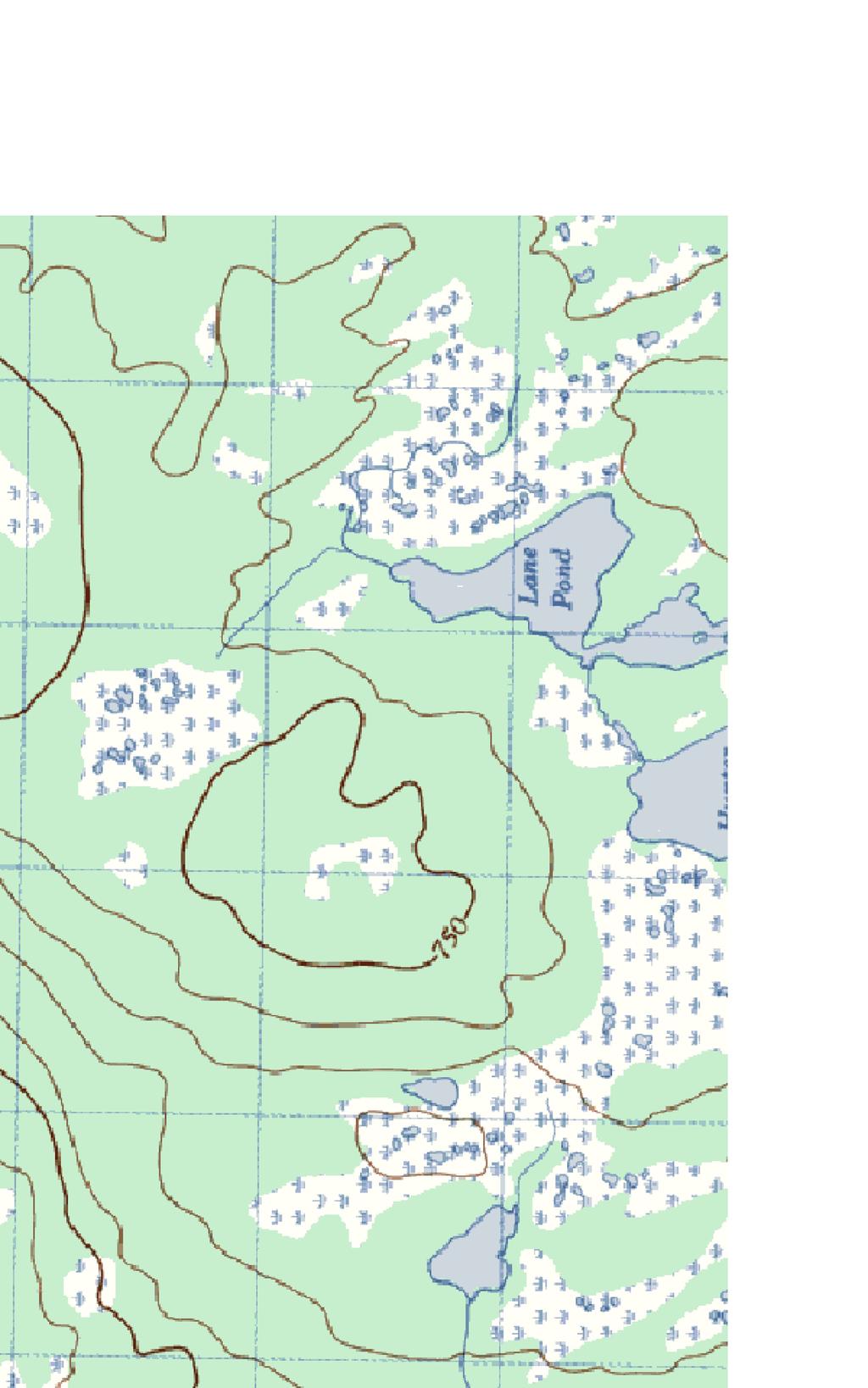
5 Introduction: The HL1 property consists of twenty nine mineral claims within Licence M. The property was staked in May 2009 when the ground came open for staking. The ground was staked for its gold potential. With two major gold prospects (Mosquito Hill and Brady) within a few kilometers and within the same belt of rocks the potential to find gold mineralization is good. This report serves as the 1st year assessment report on Licence M. Location and Access: The HL1 property (Figure 1) is located 50 kilometers south of Grand Falls in NTS 2D/05. A logging access road 7 kilometers south of the bridge over the Northwest Gander River on the Baie d Espoir highway provides access to the property (Figure 2). A bridge on the logging access road over the Little Gull River has recently been removed, making access more difficult during periods of high water flow. Figure 1 - Property Location: 1
6 Figure 2 - Property Location/Access: Physiography: The license area is characterized by an extensive development bogs and marshy barrens. The topography is generally very flat, occasionally disrupted by very low relief, undulating hills, which form ridges supporting the dense growth of softwood forest. 2
7 Regional Geology: The property is located in the Exploits subzone in the east-central part of the Dunnage Zone on the Island of Newfoundland. Rocks of the Dunnage consist of volcanic, volcaniclastic and sedimentary rocks of island-arc and back-arc affinity interpreted to represent vestiges of the Iapetus Ocean. The Dunnage Zone is divided into the Notre Dame and Exploits subzones, separated by the Red Indian Line. The evolution of the Dunnage is divided into a pre to syn accretionary and a post accretionary stage. The initial Cambrian to Mid-Ordovician pre to syn accretionary phase is marked by a periods volcanism and sedimentation in island-arc and back-arc basins. The syn-accretionary phase (initial closure of Iapetus Ocean) resulted in the structural emplacement of Notre Dame subzone rocks over the continent of Laurentia and the Exploits subzone rocks over the Gondwana continental margin. Post-accretion activation and reactivation of large strike-slip faults led to the deposition of Silurian fluviatile sedimentary and terrestrial volcanic rocks. Siluro-Devonian deformation (Salinic orogeny) resulted in crustal thickening that caused regional greenschist and amphibolite grade metamorphism and crustal melting that resulted in widespread plutonism. Local and Property Geology: The HL1 property situated in the Dunnage tectonostratigraphic zone of the Newfoundland Appalachians at the eastern margin of a large elliptical structure informally referred to as the Tim Horton complex. The structure is outlined by a variably thick zone of Lower Paleozoic ultramafic rocks that lie at the base of the Dunnage Zone and enclose possible Gander Zone metasedimentary correlatives of the Mount Cormack Terran (Spruce Brook Formation). Colman-Sadd and Swinden (1984) have interpreted the ultramafic rocks to be part of a major allochthon thrust eastwards upon sediments of continental affinity during the Acadian Orogeny. These ultramafic rocks are remnants of a tectonic window. Individually the three regions are called the Great Bend Complex, Coy Pond Complex and Pipestone Pond Complex. The Coy Pond Complex rocks in the west area are highlighted by a regional magnetic high that reflects the distribution of the mafic -ultramfic rocks. Plutonic felsic rocks of Late Cambrian to Middle Ordovician age occur within the Coy Pond complex and the southern extent of the Coy Pond Complex is truncated by the large Partridgeberry Hills granite. The Spruce Brook Formation of Middle Ordovician age consists of gneisses and clastic sedimentary rocks, including their metamorphic derivatives. The sedimentary rocks are mainly medium to thick bedded grey quartzitic sandstone, interbedded with siltstone, shale and schist with lesser conglomerate and migmatite. The Bay D Espoir Group in the HL2 property area is represented by the North Steady Pond Formation which consists of felsic volcanics and marine siliciclastic sedimentary rocks. The Baie d Espoir Group siliciclastic marine rocks appear to be direct correlatives with Davidsville Group rocks mapped on the NTS sheet 2D/04 (Colman-Sadd et al open file NFLD/2616, version 4). 3

8 Figure 3 Local and Property Geology: Legend Baie d'espoir Group - COsx Coy Pond Complex - COux Partridgeberry Hills - COGX 4
9 Previous Work: Within the last few years the area has seen a considerable amount of mineral exploration. North of the property two significant gold prospects are currently or very recently being further explored by drilling. The two prospects, (Figure 2). Mosquito Hill and Brady returned drill core intercepts up to 35 meters at 2.21 g/t Au and 35 meters at 1.1 g/t Au respectively (Golden Dory press release dated Feb 04/10). The Ground covered by Licence M has seen a limited amount of mineral exploration including drilling carried out by Gallery Resources in The drilling based on IP responses encountered widespread disseminated and stringer arsenopyrite and pyrite from surface to a core depth of 193 meters in a intercalulated volcanic sedimentary sequence. Alteration within the volcanic rocks consisted of silca, sericite, carbonate, chlorite and epidote. Only minor gold mineralization over narrow widths were reported, (Janes & French, 2004). Current Work: A total of twenty-nine man days, six of which were travel days from St. John s (1 trip) and Stephenville Crossing(2 trips), were spend accessing and exploring the property. A total of ten rock and seven soil samples were collected and assayed (Figure 4). Of the samples, a high gold value of 8733 ppb was returned from a sub-angular quartz vein boulder located along the shore line of Lane Pond. A sample of massive pyrite in the same area failed to return gold values above the detection limit. Two samples of sil. volcanic float, one to the west of Lane Pond, the other to the east of the pond, returned gold values of 2845 and 1040 ppb respectively. A narrow, up to 5 cm wide, felsic volcanic hosted, sphalerite rich quartz vein was discovered to the north of Lane Pond. A selective grab sample from the vein returned 6.30 % Zn and 675 ppb gold. A soil sample collected five meters along strike returned.49% Zn and 92 ppb Au. This mineralization is comparable to high grade zinc mineralization found to the south by Gallery Resources at the Katie Property. A soil sample collected near the Gallery drill hole mentioned earlier, returned 328 ppb Au suggesting that there could be higher grade mineralization in the area than encountered in the drill core. 5
10
11 Sample Description: Sample Type Description Mineralization Easting Northing HL101 float ultramafic 4-5% diss py - sil. subangular HL102 outcrop sedimentary 5-8% fine diss py - sil HL103 outcrop qtz vein sed hosted HL104 float qtz vein float - subangular HL105 float massive py angular HL106 outcrop qtz vein 10-12% sphalerite HL107 float felsic volcanic 4-5% py - sil angular HL108 float felsic volcanic 4-5% py 1% asp - sil subangular HL109 subcrop felsic volcanic 4-5% py - sil angular HLS01 float felsic volcanic 4-5% py 1% asp - sil subangular HLS02 soil HLS03 soil HLS04 soil HLS05 soil HLS06 soil HLS07 soil HLS08 soil Recommendations: Lack of outcrop very much hindered any prospecting attempts. Further prospecting should be carried out while concentrating on soil sampling. 7
12 References Colman-Sadd, S.P., and Swinden, H.S. 1984: A tectonic window in central Newfoundland? Geological evidence that the Appalachian Dunnage Zone may be allochthonous: in Canadian Journal of Earth Sciences, volume 21, pages Colman-Sadd, S.P. and Crisby-Whittle, L.V.J. (Compilers), 2002: Partial bedrock geology dataset for the Island of Newfoundland (NTS 2E, 12H, 12G and parts of 1M, 2D, 2L, 11P, 12A, 12B, 12I). Open File NFLD/2616 Version 4.0. th Janes, K., and French, V. 2004: Supplementary 4 Year Report. Report 002D/05/005. 8
13
14 1 of 2 APPENDIX II - Analytical Certificates
15 2 of 2 APPENDIX II - Analytical Certificates
First Year Assessment Report: Report on Prospecting, Rock and Soil Sampling Carried Out From September/2012 to December/2012.
 First Year Assessment Report: Report on Prospecting, Rock and Soil Sampling Carried Out From September/2012 to December/2012 on the Clarkes Pond Property Licence 020334M Northwest Gander River,Central
Compilation Report Hawke Hill South. Licence No M NTS 01N/06. Newfoundland and Labrador. Submitted by Gordon E. Cooper and Kevin P.
 Compilation Report 2010 Hawke Hill South Licence No. 017282M NTS 01N/06 Newfoundland and Labrador Submitted by Gordon E. Cooper and Kevin P. Ryan For Kevin P. Ryan (Licence holder) January, 2011 Work Year:
SECOND and THIRD YEAR ASSESSMENT REPORT PROSPECTING LICENCE M, ROCK CUT PROPERTY, NTS 1N/12, NEWFOUNDLAND. ROY FRENCH (licence holder )
") SECOND and THIRD YEAR ASSESSMENT REPORT Of PROSPECTING On LICENCE 013704M, ROCK CUT PROPERTY, NTS 1N/12, NEWFOUNDLAND. By ROY FRENCH (licence holder ) Work Conducted: Sept. 17, 2008 Nov. 03, 2009 Total
SECOND and THIRD YEAR ASSESSMENT REPORT Of PROSPECTING On LICENCE 013704M, ROCK CUT PROPERTY, NTS 1N/12, NEWFOUNDLAND. By ROY FRENCH (licence holder ) Work Conducted: Sept. 17, 2008 Nov. 03, 2009 Total
FOURTH YEAR ASSESSMENT REPORT PROSPECTING AND GEOCHEMICAL INVESTIGATIONS LICENCE M SITUATED WITHIN NTS MAP SHEET 02E/02 BRINKS POND CENTRAL
 FOURTH YEAR ASSESSMENT REPORT PROSPECTING AND GEOCHEMICAL INVESTIGATIONS LICENCE 016249M SITUATED WITHIN NTS MAP SHEET 02E/02 BRINKS POND CENTRAL NEWFOUNDLAND I TABLE OF CONTENTS 1:0 INTRODUCTION PAGE
H/16/2065
 2015-02-06 2012-02-21 012H/16/2065 TENTH YEAR ASSESSMENT REPORT OF SITE VISIT AND POLISHING TESTS ON LIC. # 19491m BAIE VERTE PENINSULA, NL NTS 12H/16 BY NATHANIEL NOEL MSc. FOR E. MICHELE NOEL MINERAL
First Year assessment Report on Prospecting and Rock sampling, King George property, License M NTS 12A/05 Newfoundland and Labrador.
 First Year assessment Report on Prospecting and Rock sampling, King George property, License 016679M NTS 12A/05 Newfoundland and Labrador. Submitted by Shawn Rose For Shawn Rose January 2011 Work year
FIRST YEAR ASSESSMENT REPORT PROSPECTING LICENCE 16512M MARYSTOWN AREA, BURIN PENINSULA NTS 1M/3
 FIRST YEAR ASSESSMENT REPORT OF PROSPECTING ON LICENCE 16512M MARYSTOWN AREA, BURIN PENINSULA NTS 1M/3 BY NATHANIEL NOEL MSc. FOR E. MICHELE NOEL MINERAL LICENCES: 16512 M WORK CONDUCTED: MID-SEPTEMBER
Linear North Property Licence 15923M
 KriASK Syndicate First Year (2009/10) Assessment Report (Prospecting, Due Diligence) On the Linear North Property Licence 15923M Gander River Area, Central Newfoundland NTS: 2 D/15 By Peter M. Dimmell,
%+ '$# $) %, %*$ " $ $ ' %' !()'-!" %( %"%! " *'+ - % %$! $)! " $)!" !$ ' "! )( ! $ '%& ')- % % "!#( (( ((# $) ' ) ((* & *# ' % %"*# ( !!
 %, %*$ $ $ ' %' !()'-! %( %%! *'+ - % %$! $)! $)! !$ ' ! )( ! $ '%& ')- % % !#( (( ((# $) ' ) ((* & *# ' % %*# ( !!") 002E/13/1893 THIRD YEAR ASSESSMENT REPORT OF PROSPECTING ON LICENCE 19122M and 19124M Betts Cove, NL NTS 2E/13 BY NATHANIEL NOEL MSc. FOR E. MICHELE NOEL MINERAL LICENCE: 19122M 19124M WORK CONDUCTED:
002E/13/1893 THIRD YEAR ASSESSMENT REPORT OF PROSPECTING ON LICENCE 19122M and 19124M Betts Cove, NL NTS 2E/13 BY NATHANIEL NOEL MSc. FOR E. MICHELE NOEL MINERAL LICENCE: 19122M 19124M WORK CONDUCTED:
Assessment Report (Prospecting) BLACK RIDGE PROPERTY. 12H/07 and 12H/08. License Numbers
 BLACK RIDGE PROPERTY. 12H/07 and 12H/08. License Numbers") Assessment Report (Prospecting) BLACK RIDGE PROPERTY 12H/07 and 12H/08 License Numbers First year - 14411M (supplementary) Second year - 13978M (supplementary) Submitted by: Wayne Reid, B.Sc., P.Geo Metals
Assessment Report (Prospecting) BLACK RIDGE PROPERTY 12H/07 and 12H/08 License Numbers First year - 14411M (supplementary) Second year - 13978M (supplementary) Submitted by: Wayne Reid, B.Sc., P.Geo Metals
FIFTH YEAR ASSESSMENT REPORT PROSPECTING ACTIVITY ON LICENCE 11579M SPRICY POND PROPERTY LICENCE 11582M FLATWATER POND PROPERTY
 FIFTH YEAR ASSESSMENT REPORT PROSPECTING ACTIVITY ON LICENCE 11579M SPRICY POND PROPERTY LICENCE 11582M FLATWATER POND PROPERTY NTS MAP SHEET 12H/16 ZONE 21 NAD 27 Work conducted April to Dec. 2010 Written
Anthill Resources Yukon - An Update on the Einarson Project
 Anthill Resources Yukon - An Update on the Einarson Project The Eastern Extension of a Carlin-type Gold Trend in the Selwyn Basin Anthill Resources Ltd Yukon Claim Holdings Over 2400 km 2 Property Location
A GUIDE TO WRITING AN ASSESSMENT REPORT ON YOUR CLAIMS
 A GUIDE TO WRITING AN ASSESSMENT REPORT ON YOUR CLAIMS PLEASE NOTE! In the following pages, suggestions and advice are in italics, under each heading. Use as a guideline only. Items in bold should be changed
ASSESSMENT REPORT ON THE PEAVINE PROJECT. DGW & Associates # Alberni Street, Vancouver, British Columbia, V6E 4V2
 ASSESSMENT REPORT ON THE PEAVINE PROJECT KAMLOOPS MINING DIVISION BRITISH COLUMBIA NTS 082M 12 Latitude 51 36' 19.0"North -- Longitude --119 47' 27.0"West UTM Zone 11, NAD 83 5720827N 306744E Prepared
The McPhillamys Gold Deposit, Discovery History & Geology. Presenter: Tara French
 The McPhillamys Gold Deposit, Discovery History & Geology. Presenter: Tara French Forward-Looking Statements This presentation contains forward-looking statements. without limitation: Estimates of future
4th YEAR ASSESSMENT REPORT LINE CUTTING, SOIL GEOCHEMISTRY. on the. Little River Property, Mineral Licence 15458M
 4th YEAR ASSESSMENT REPORT On LINE CUTTING, SOIL GEOCHEMISTRY on the Little River Property, Mineral Licence 15458M Baie D espoir Area, Newfoundland, NTS 01M/13, by GARY WOODS, P.Geo. Work Conducted: June
3/5/05 Dr. Stewart 1
 I. Physiography of Appalachian Mountains A. Introduction 1. These mountains extend from NE Canada to Georgia 2. They are the remains of a deeply eroded, ancient mountain chain once larger than the Himalayans
Gold Mineralization Potential in a Wabigoon Subprovince Granite-Greenstone Terrane, International Falls Area, Minnesota
 Gold Mineralization Potential in a Wabigoon Subprovince Granite-Greenstone Terrane, International Falls Area, Minnesota Manitoba Ontario Mn The State of Minnesota is located in the north-central portion
Lands Parcels in IOL CO-20
 Lands Parcels in IOL CO-20 1 CO-20 The Izok Corridor Lupin - multi-million ounce past gold production (3.6 million oz of gold at average grade of 9.3 g/t Au) Approximately 1 million ounces of undeveloped
FIRST YEAR ASSESSMENT REPORT ON THE HAMMERDOWN SOUTH PROPERTY KING S POINT AREA, NEWFOUNDLAND
 FIRST YEAR ASSESSMENT REPORT ON THE HAMMERDOWN SOUTH PROPERTY KING S POINT AREA, NEWFOUNDLAND Licenses: 017558M, 017559M, 017560M and 017561M NTS Mapsheets: 012H/08 and 012H/09 Garry Fraser 66a Frontenac
%+ '$# $) %, %*$ " $ $ ' %' !()'-!" %( %"%! " *'+ - % %$! $)! " $)!" !$ ' "! )( ! $ '%& ')- % % "!#( (( ((# $) ' ) ((* & *# ' % %"*# ( !!
 %, %*$ $ $ ' %' !()'-! %( %%! *'+ - % %$! $)! $)! !$ ' ! )( ! $ '%& ')- % % !#( (( ((# $) ' ) ((* & *# ' % %*# ( !!") 001L/14/0218 First Year Assessment Report of Prospecting, Rock and Stream Sediment Sampling On Licence 18880M, NTS 1L/14 Burin Peninsula Newfoundland and Labrador Submitted by: Keith Kelloway Work year:
001L/14/0218 First Year Assessment Report of Prospecting, Rock and Stream Sediment Sampling On Licence 18880M, NTS 1L/14 Burin Peninsula Newfoundland and Labrador Submitted by: Keith Kelloway Work year:
Drill locations for the 2015 program are highlighted in the geology map below.
 2015 Exploration Program The exploration program plan at KSM for 2015 was designed to improve the understanding of block cave targets and support engineering/environmental aspects of development scenarios.
Summary of Rover Metals Geologic Mapping Program at the Up Town Gold Project, Northwest Territories
 October 13, 2017 Summary of Rover Metals Geologic Mapping Program at the Up Town Gold Project, Northwest Territories Vancouver, British Columbia, Canada - Rover Metals Corp., Rover, is pleased to provide
As compaction and cementation of these sediments eventually occur, which area will become siltstone? A) A B) B C) C D) D
 A B) B C) C D) D") 1. A student obtains a cup of quartz sand from a beach. A saltwater solution is poured into the sand and allowed to evaporate. The mineral residue from the saltwater solution cements the sand grains together,
1. A student obtains a cup of quartz sand from a beach. A saltwater solution is poured into the sand and allowed to evaporate. The mineral residue from the saltwater solution cements the sand grains together,
1 FILMED 1. FILE NO:!..rsrru -* -. GRAND TWO CLAIM
 FILE NO:!..rsrru -* -. GRAND TWO CLAIM REPORT ON 1993 ASSESSMENT WORK GRAND TWO CLAIM REC. NO. 301849 NELSON MINING DIVISION NTS MAP SHEET 82F6/W 49 25'51" NORTH 117 18'08" WEST 1 FILMED 1 AUTHOR: R. Jordan,
CEE 437 Lecture 10 Rock Classification. Thomas Doe
 CEE 437 Lecture 10 Rock Classification Thomas Doe Igneous Origins Intrusive Batholithic or plutonic: phaneritic Dikes or sills that chill rapidly: aphanitic Extrusive deposition as melt (lava) pyroclastic
Lin Chen Robert A Creaser Daniel J Kontak Oct 29th, 2014
 FURTHER Re-Os ARSENOPYRITE GEOCHRONOLOGY FROM SELECTED MEGUMA AU DEPOSITS, MEGUMA TERRANE, NOVA SCOTIA: POSSIBLE EVIDENCE FOR A PROTRACTED GOLD-FORMING SYSTEM Lin Chen Robert A Creaser Daniel J Kontak
ON THE LOST GOLD PROPERTY
 ON THE LOST GOLD PROPERTY NELSON MINING DIVISION BRITISH COLUMBIA Latitude: 49 18 North Longitude: 117 29.West TRIM MAPS: 82F1023,033 NTS: 8tF/5,6 By: Fred Critchlow . TABLE OF CONTENTS r PAGE lutroduction
ASSESSMENT REPORT PROSPECTING PROGRAM ION/DIRTY JACK PROPERTY NELSON MINING DIVISION N.T.S. MAP SHEET 82F.023 UTM COORDINATES N E
 ASSESSMENT REPORT PROSPECTING PROGRAM ION/DIRTY JACK PROPERTY NELSON MINING DIVISION N.T.S. MAP SHEET 82F.023 UTM COORDINATES 5454800N - 0455235E Work Performed Summer 2007 OWNER >* ' Tom Kennedy >8 404-22
The MAPLE BAY PROJECT Copper Silver - Gold
 The MAPLE BAY PROJECT Copper Silver - Gold Good grade and tonnage potential within close proximity to Tidewater The Maple Bay Copper Silver Gold Project covers highly favourable geological host rocks of
WEALTH MINERALS LTD. Mackenzie Gold Project
 WEALTH MINERALS LTD. Mackenzie Gold Project the Search for a Sediment Hosted Vein Deposit Presented by Paul Klipfel Mineral ineral Resource Services ervices Inc. Mackenzie Misinchinka Range Property Location
New gold discovery in the Paleoproterozoic Mauken greenstone belt
 New gold discovery in the Paleoproterozoic Mauken greenstone belt Mauken greenstone belt The Paleoproterozoic Mauken greenstone belt is situated in an unexplored and untested terrain in Northern Norway.
SECOND DRILL HOLE IHAD2 INTERSECTS MINERALIZED TAPLEY HILL FORMATION AND MINERALIZED BASEMENT IRON FORMATION
 Suite 304, 22 St Kilda Road St Kilda Vic 3182 Ph: +61 3 9692 7222; Fax: +61 3 9529 8057 For Immediate Release 14 th September 2007 SECOND DRILL HOLE IHAD2 INTERSECTS MINERALIZED TAPLEY HILL FORMATION AND
Nachicapau Zn-Cu project THE NEXT MAJOR DISCOVERER IN QUEBEC
 Nachicapau Zn-Cu project THE NEXT MAJOR DISCOVERER IN QUEBEC Nachicapau Project - Location Willbob & Pallas Projects Kuujjuaq Located about 150km south of Kuujjuaq, the closest community (has a port) 215
Copper and Zinc Production, Disciplined Growth. S I T E V I S I T O C T O B E R % Owned Projects
 Copper and Zinc Production, Disciplined Growth. S I T E V I S I T O C T O B E R 2 0 1 6 100% Owned Projects Serbia assets Timok Magmatic Complex Rakita Joint Venture 4 exploration permits in the Bor region,
%+ '$# $) %, %*$ " $ $ ' %' !()'-!" %( %"%! " *'+ - % %$! $)! " $)!" !$ ' "! )( ! $ '%& ')- % % "!#( (( ((# $) ' ) ((* & *# ' % %"*# ( !!
 %, %*$ $ $ ' %' !()'-! %( %%! *'+ - % %$! $)! $)! !$ ' ! )( ! $ '%& ')- % % !#( (( ((# $) ' ) ((* & *# ' % %*# ( !!") 001M/16/0790 TENTH YEAR ASSESSMENT REPORT OF PROSPECTING ON LICENCE 18624M HICKEYS POND AREA, BURIN PENINSULA NTS 1M/16 BY NATHANIEL NOEL MSc. FOR E. MICHELE NOEL MINERAL LICENCES: 18624 M WORK CONDUCTED:
001M/16/0790 TENTH YEAR ASSESSMENT REPORT OF PROSPECTING ON LICENCE 18624M HICKEYS POND AREA, BURIN PENINSULA NTS 1M/16 BY NATHANIEL NOEL MSc. FOR E. MICHELE NOEL MINERAL LICENCES: 18624 M WORK CONDUCTED:
Geology of Quesnel and Stikine terranes and associated porphyry deposits. Jim Logan Paul Schiarizza
 Geology of Quesnel and Stikine terranes and associated porphyry deposits Jim Logan Paul Schiarizza Quesnel and Stikine terranes Major cordilleran terranes characterized by similar Late Triassic Early Jurassic
Mountain Building. Mountain Building
 Mountain Building Mountain building has occurred during the recent geologic past American Cordillera the western margin of the Americas from Cape Horn to Alaska Includes the Andes and Rocky Mountains Alpine
MINERALIZED ALTERATION ZONE AND NEW DIMENSION-STONE SHOWINGS SOUTHWEST OF CORNER BROOK, WESTERN NEWFOUNDLAND
 GOVERNMENT OF NEWFOUNDLAND AND LABRADOR Department of Mines and Energy Geological Survey MINERALIZED ALTERATION ZONE AND NEW DIMENSION-STONE SHOWINGS SOUTHWEST OF CORNER BROOK, WESTERN NEWFOUNDLAND I.
7 Sedimentation and tectonics at a mid- Ordovician to Silurian active margin
 80 Mountain Building in Scotland 7 Sedimentation and tectonics at a mid- Ordovician to Silurian active margin 7.1 Introduction In mid-ordovician to Silurian times, the Grampian mountains underwent exhumation,
MEMO. TO: Dennis Lapoint CC: FROM: Eriaan Wirosono DATE: April, 20 th 2014 SUBJECT: Exploration activity report March-April 2014_EW
 TO: Dennis Lapoint CC: FROM: Eriaan Wirosono DATE: April, 20 th 2014 SUBJECT: Exploration activity report March-April 2014_EW MEMO 1. Highlights and Productivity Overview pan sampling on target Areas 1
Copyright McGraw-Hill Education. All rights reserved. No reproduction or distribution without the prior written consent of McGraw-Hill Education
 Copyright McGraw-Hill Education. All rights reserved. No reproduction or distribution without the prior written consent of McGraw-Hill Education Tibetan Plateau and Himalaya -southern Asia 11.00.a VE 10X
DÉCOUVERTE Positioned for Discovery in James Bay, Quebec. Investor Presentation, January 2018 by Danae Voormeij, MSc, PGeo
 DÉCOUVERTE Positioned for Discovery in James Bay, Quebec Investor Presentation, January 2018 by Danae Voormeij, MSc, PGeo Location Maps and Infrastructure Location: Durango Resources 100% owned Découverte
We are committed to providing accessible customer service. If you need accessible formats or communications supports, please contact us.
 We are committed to providing accessible customer service. If you need accessible formats or communications supports, please contact us. Nous tenons à améliorer l accessibilité des services à la clientèle.
Uncovering The Riches of the Abitibi Greenstone Belt of Canada
 1 TSX.V: ALZ June 2016 Uncovering The Riches of the Abitibi Greenstone Belt of Canada The Haultain Gold Discovery The Abitibi Greenstone Belt & Gold 170+ million oz of gold produced to date from more than
it AUSIMM COBAR MINING SEMINAR
 Straits Resources Limited it AUSIMM COBAR MINING SEMINAR Brownfields Exploration at Girilambone: Understanding the Mineralised Systems August 2010 Phil Shields / Phil Jones LOCATION TRITTON OPERATIONS
Golden Cross Resources
 Golden Cross Resources Labrador Uranium Joint Venture with Altius Resources Update - November 2007 Labrador Uranium - Canada LABRADOR URANIUM PROPERTIES Golden Cross Resources signed an agreement with
Which rock is shown? A) slate B) dunite C) gneiss D) quartzite
 slate B) dunite C) gneiss D) quartzite") 1. Which metamorphic rock will have visible mica crystals and a foliated texture? A) marble B) quartzite C) schist D) slate 2. The recrystallization of unmelted material under high temperature and pressure
1. Which metamorphic rock will have visible mica crystals and a foliated texture? A) marble B) quartzite C) schist D) slate 2. The recrystallization of unmelted material under high temperature and pressure
Preliminary Geochemical Analysis of Various Gold Occurrences Within the Volcano-sedimentary Rocks of the Annidale Belt, Southern New Brunswick
 Preliminary Geochemical Analysis of Various Gold Occurrences Within the Volcano-sedimentary Rocks of the Annidale Belt, Southern New Brunswick Kathleen Thorne New Brunswick Department of Natural Resources
%+ '$# $) %, %*$ " $ $ ' %' !()'-!" %( %"%! " *'+ - % %$! $)! " $)!" !$ ' "! )( ! $ '%& ')- % % "!#( (( ((# $) ' ) ((* & *# ' % %"*# ( !!
 %, %*$ $ $ ' %' !()'-! %( %%! *'+ - % %$! $)! $)! !$ ' ! )( ! $ '%& ')- % % !#( (( ((# $) ' ) ((* & *# ' % %*# ( !!") 001M/09/0796 SEVENTH YEAR ASSESSMENT REPORT ON LIC. 13640M FIRST YEAR ASSESSMENT REPORT ON LIC. 18523M FIRST YEAR ASSESSMENT REPORT ON LIC. 18524M OF PROSPECTING ON TOWER WEST AREA, BURIN PENINSULA NTS
001M/09/0796 SEVENTH YEAR ASSESSMENT REPORT ON LIC. 13640M FIRST YEAR ASSESSMENT REPORT ON LIC. 18523M FIRST YEAR ASSESSMENT REPORT ON LIC. 18524M OF PROSPECTING ON TOWER WEST AREA, BURIN PENINSULA NTS
MORE HIGH-GRADE GOLD INTERSECTIONS FROM CITADEL S SHAYBAN PROJECT, SAUDI ARABIA
 Citadel Resource Group Limited ASX Release 7th July 2009 MORE HIGH-GRADE GOLD INTERSECTIONS FROM CITADEL S SHAYBAN PROJECT, SAUDI ARABIA Highlights: LATEST RC IN-FILL AND EXTENSIONAL DRILLING CONTINUES
Quiz Nine (9:30-9:35 AM)
") Quiz Nine (9:30-9:35 AM) UNIVERSITY OF SOUTH ALAAMA GY 112: Earth History Lecture 25: Paleozoic 2: More Laurentia! Instructor: Dr. Douglas W. Haywick Last Time The Paleozoic of North America 1) Laurentian
Quiz Nine (9:30-9:35 AM) UNIVERSITY OF SOUTH ALAAMA GY 112: Earth History Lecture 25: Paleozoic 2: More Laurentia! Instructor: Dr. Douglas W. Haywick Last Time The Paleozoic of North America 1) Laurentian
Rapier Gold provides exploration update on the Pen Gold Project, 37.6 g/t sample taken in new target area
 Suite 2270-1055 W. Georgia Street P.O. Box 11144, Royal Centre Vancouver, BC V6E 3P3 Telephone: 604-569-0049 rapiergold.com October 4, 2013 TSX-V: RPR Rapier Gold provides exploration update on the Pen
Structure of the western Brooks Range fold and thrust belt, Arctic Alaska
 Trabajos de Geología, Universidad de Oviedo, 29 : 218-222 (2009) Structure of the western Brooks Range fold and thrust belt, Arctic Alaska J. DE VERA 1* AND K. MCCLAY 2 1Now at: Shell, Rijswijk, Netherlands.
SQUARE POST PROJECT CHARTERS TOWERS NORTH QUEENSLAND AUSTRALIA
 SQUARE POST PROJECT CHARTERS TOWERS NORTH QUEENSLAND AUSTRALIA Square Post - Summary PROJECT DETAILS - SQUARE POST The Square Post exploration permit (EPM 18510) contains two styles of mineralisation:
Montgomery Bedrock Geology 21d-Gowganda Formation: conglomerate, sandstone, siltstone, argillite
 Work Report 2014 Trenching Montgomery Township G-3303 Claim #4259384,4245818 Sault Ste. Marie Mining Division Michael & Yvon Gagne Montgomery Copper Property 1 P a g e 2 P a g e Montgomery Bedrock Geology
Grassroots Exploration for Gold in Labrador
 Grassroots Exploration for Gold in Labrador Roger Moss, Nikos Explorations Ltd., Shawn Ryan, RyanWood Exploration, John Clarke, GroundTruth Exploration. Mineral Resources Review November 1 st -4 th 2017
Características e Critérios da Exploração de Depósitos Orogenéticos de Ouro
 Características e Critérios da Exploração de Depósitos Orogenéticos de Ouro Richard Goldfarb, goldfarb@usgs.gov, SIMEXMIN 2012 Archean Lode Gold Deposits Greenstone Belts in granitoid-greenstone terranes
Table of Contents. List of Figures
 12th Year Assessment Report on Mapping, Prospecting and Geochemical Sampling of the Katie Property, Central Newfoundland and Labrador on Licences 16643M, 12985M, and 12988M NTS 2D/05 For: Alterra Resources
Queensland Mining Corporation Limited
 Queensland Mining Corporation Limited ABN 61 109 962 469 ASX Release 29 th July 2011 Drilling Commenced at Duck Creek Copper-Gold Project, Cloncurry, North-west Queensland Highlights RC drilling has commenced
CARIBOO - GRIZZLY ZINC PROJECT
 CARIBOO - GRIZZLY ZINC PROJECT The Grizzly Lake or Cariboo Zinc property straddles the gravel Weldwood 8400 logging road in the Grizzly Lake area about 55 kilometres northeast of Likely. Roads constructed
TABLE OF CONTENTS. Page A. INTRODUCTION 1 B. LOCATION AND ACCESS 2 C. CLAIM INFORMATION 2 D. BRIEF HISTORY 3 E. REGIONAL GEOLOGICAL FRAMEWORK 4
 TABLE OF CONTENTS Page A. INTRODUCTION 1 B. LOCATION AND ACCESS 2 C. CLAIM INFORMATION 2 D. BRIEF HISTORY 3 E. REGIONAL GEOLOGICAL FRAMEWORK 4 F. RECONNAISSANCE BEDROCK GEOLOGY 5 G. FIELD PROCEDURES 5
Geology (Mellow) Hike, Santa Lucia Memorial Park February 16, I. Overview of Santa Lucia Range geology and tectonic history
 Hike, Santa Lucia Memorial Park February 16, I. Overview of Santa Lucia Range geology and tectonic history") Geology (Mellow) Hike, Santa Lucia Memorial Park February 16, 2015 I. Overview of Santa Lucia Range geology and tectonic history A. Basement Rocks 1. Salinian Block Rocks Sierra Nevada Type, continental
Geology (Mellow) Hike, Santa Lucia Memorial Park February 16, 2015 I. Overview of Santa Lucia Range geology and tectonic history A. Basement Rocks 1. Salinian Block Rocks Sierra Nevada Type, continental
for the Greenwood Mining Division, B.C. NTS 82E/7W Latitude 49' 27' W, Longitude 118' 5 Prepared by a= D. Dylan Watt, B.Sc.
 t. b LOGnO: 37~ -08 m. ACTIO#: for the AMP AMP 2 AMP 3 t AMP 4 CLAIMS Greenwood Mining Division, B.C. NTS 82E/7W Latitude 49' 27' W, Longitude 8' 5 %E c,w zc *& a w Prepared by a= -4c. D. Dylan Watt, B.Sc.
Mishi Lake Gold Property Mishibishu Lake Area, Wawa
 Mishi Lake Gold Property Mishibishu Lake Area, Wawa Location, Accessibility, Infrastructure and Local Resources The property is located 40 km west of Wawa, Ontario, in the Mishibishu Lake Area, Sault Ste.
NTS 082F03SW N W U E N
 Prospecting Report JOCELYN CLAIM NTS 082F03SW N49 09 51 W 117 14 04 11U 482906E 5445737N NELSON MINING DIVISION Martin Ross PO Box 323 Salmo BC V0G 1Z0 Jan 31, 2012 PROSPECTING REPORT JOCELYN MINERAL CLAIM
Answers: Internal Processes and Structures (Isostasy)
") Answers: Internal Processes and Structures (Isostasy) 1. Analyse the adjustment of the crust to changes in loads associated with volcanism, mountain building, erosion, and glaciation by using the concept
Answers: Internal Processes and Structures (Isostasy) 1. Analyse the adjustment of the crust to changes in loads associated with volcanism, mountain building, erosion, and glaciation by using the concept
ASX / MEDIA RELEASE 6 MAY MILE SILVER-LEAD-ZINC DISCOVERY; HIGH GRADE SILVER-GOLD IN ROCK CHIPS AT RUBY SILVER
 ASX / MEDIA RELEASE 6 MAY 2011 4-MILE SILVER-LEAD-ZINC DISCOVERY; HIGH GRADE SILVER-GOLD IN ROCK CHIPS AT RUBY SILVER Highlights: Silver-lead-zinc discovery at 4-Mile; mineralisation intersected in all
GEOLOGICAL INVESTIGATION IN THE ISLAND LAKE GREENSTONE BELT, NORTHWESTERN SUPERIOR PROVINCE, MANITOBA (PARTS OF NTS 53E/15 & 16) GS-18
 GS-18") GS-18 GEOLOGICAL INVESTIGATION IN THE ISLAND LAKE GREENSTONE BELT, NORTHWESTERN SUPERIOR PROVINCE, MANITOBA (PARTS OF NTS 53E/15 & 16) by S. Lin, H.D.M. Cameron, E.C. Syme and F. Corfu 1 Lin, S., Cameron,
GS-18 GEOLOGICAL INVESTIGATION IN THE ISLAND LAKE GREENSTONE BELT, NORTHWESTERN SUPERIOR PROVINCE, MANITOBA (PARTS OF NTS 53E/15 & 16) by S. Lin, H.D.M. Cameron, E.C. Syme and F. Corfu 1 Lin, S., Cameron,
Global Tectonics. Kearey, Philip. Table of Contents ISBN-13: Historical perspective. 2. The interior of the Earth.
 Global Tectonics Kearey, Philip ISBN-13: 9781405107778 Table of Contents Preface. Acknowledgments. 1. Historical perspective. 1.1 Continental drift. 1.2 Sea floor spreading and the birth of plate tectonics.
Bedrock mapping and geological characterization in the northern Glennie domain, west-central Reindeer Zone
 Bedrock mapping and geological characterization in the northern Glennie domain, west-central Reindeer Zone Samantha Van De Kerckhove, Ryan Morelli and Dylan Deck Saskatchewan Geological Open House, 2017
Structural geology and gold metallogeny of the New Britannia mine area, Snow Lake, Manitoba
 Structural geology and gold metallogeny of the New Britannia mine area, Snow Lake, Manitoba Chris Beaumont-Smith Manitoba Geological Survey Boundary zone New Britannia Trans-Hudson Orogen 50 km 100 km
Evolution of Continents Chapter 20
 Evolution of Continents Chapter 20 Does not contain complete lecture notes. Mountain belts Orogenesis the processes that collectively produce a mountain belt Includes folding, thrust faulting, metamorphism,
DiaMine Exploration Inc. Pickle Lake Option Property
 DiaMine Exploration Inc. Pickle Lake Option Property Rock Sampling Program and Field Observations Claims 4249174, 4249175, 4249176 and 4249177, Kapkichi Lake Area (G-2081) And Claims 4249178, 4249179 and
Geologic Mapping Regional Tournament Trial Event
 Geologic Mapping Regional Tournament Trial Event A TEAM OF UP TO: 2 Team Name AVAILABLE TIME: 50 min Required Materials: Each team MUST have a protractor, ruler, non-programmable calculator, colored pencils,
for the Greenwood Mining Division, B.C. NTS 82E/7W 29' W, Longitude 118' 53' N Prepared by D. Dylan Watt, B.Sc.
 for the FltE NO: u VOLT 1, VOLT 2, VOLT 3, & VOLT 4 CLAIMS Greenwood Mining Division, B.C. NTS 82E/7W Latitude 49' 29' W, Longitude 118' 53' N Prepared by D. Dylan Watt, B.Sc. #309-1996 Trutch Street Vancouver,
Quaternary clays alluvial sands of the Shepparton Formation overlie the basement rocks.
 NAGAMBIE GOLDFIELD Regional Geological Setting The Nagambie Project is located within the Melbourne Structural Zone of Victoria. The lithologies range in age from the Upper Silurian Broadford Formation
DO NOT WRITE ON THIS EXAM ONLY WRITE ON THE ANSWER SHEET!
 DO NOT WRITE ON THIS EXAM ONLY WRITE ON THE ANSWER SHEET! Multiple Choice Questions (30 points) for each question, please choose the best answer and circle your answer on the answer sheet (do not write
If you have any concerns or questions regarding this report, please do not hesitate to contact me, Julie Labonte, at (709)
") To: Mineral Lands Division, Department of Natural Resources Exploration Monitoring- Mineral Assessment Reporting From: Julie A. Labonte, P. Geo Project Geologist, Cornerstone Resources Inc. 26 Kyle Ave.,
To: Mineral Lands Division, Department of Natural Resources Exploration Monitoring- Mineral Assessment Reporting From: Julie A. Labonte, P. Geo Project Geologist, Cornerstone Resources Inc. 26 Kyle Ave.,
Wind Mountain Project Summary Memo Feeder Program
 A Manex Resource Group Company Wind Mountain Project Summary Memo Feeder Program J.A. Kizis, Jr., February 07, 2018 Assays have been received for both holes drilled at Wind Mountain during late 2017 and
Prospecting Report 'S Office i DB Property, B.C. -J Negro Creek Nelson Mining District NTS 82F.050. Operator: Kootenay Gold Inc.
 . '.' I"' i9 12 Prospecting Report 'S Office i DB Property, B.C. -J Negro Creek Nelson Mining District NTS 82F.050 Operator: Kootenay Gold Inc. Owner: Darlene Lavoie Work Performed Summer of 2007 Report
%+ '$# $) %, %*$ " $ $ ' %' !()'-!" %( %"%! " *'+ - % %$! $)! " $)!" !$ ' "! )( ! $ '%& ')- % % "!#( (( ((# $) ' ) ((* & *# ' % %"*# ( !!
 %, %*$ $ $ ' %' !()'-! %( %%! *'+ - % %$! $)! $)! !$ ' ! )( ! $ '%& ')- % % !#( (( ((# $) ' ) ((* & *# ' % %*# ( !!") 001L/14/0215 Seventh Year Assessment Report on Prospecting, Rock, Stream and Soil Sampling, and Radiometric Surveying Licence 10689M, NTS 1L14 Burin Peninsula, Newfoundland Submitted by: Keith Kelloway
001L/14/0215 Seventh Year Assessment Report on Prospecting, Rock, Stream and Soil Sampling, and Radiometric Surveying Licence 10689M, NTS 1L14 Burin Peninsula, Newfoundland Submitted by: Keith Kelloway
GEOLOGY GL1 Foundation Unit
 Candidate Name Centre Number Candidate Number 2 General Certificate of Education Advanced Subsidiary/Advanced 451/01 GEOLOGY GL1 Foundation Unit P.M. THURSDAY, 10 January 2008 (1 hour) Examiner Question
COMBINATION OF MMI AND ENZYME LEACH METHODS IN EXPLORATION FOR GOLD IN AN AREA OF THE CANADIAN SHIELD COVERED WITH GLACIAL SEDIMENTS: A CASE STUDY
 COMBINATION OF MMI AND ENZYME LEACH METHODS IN EXPLORATION FOR GOLD IN AN AREA OF THE CANADIAN SHIELD COVERED WITH GLACIAL SEDIMENTS: A CASE STUDY Nadia Yavorskaya 450 Bonner Ave., Winnipeg, MB, Canada
PROSPECTING REPORT. Broken Hill Property. EVENT # TENURE # Tenure Name: Broken Hill. New Westminster Mining Division Map 092H
 2009-2010 PROSPECTING REPORT Broken Hill Property EVENT # 4514071 TENURE # 600988 Tenure Name: Broken Hill New Westminster Mining Division Map 092H Central Coordinate Reference 121 24 26.2 W Longitude
Big Island Field Trip
 Big Island Field Trip Space Still Available Group Airline Tickets May be available if enough people sign on If interested send email to Greg Ravizza Planning Meeting Next Week Will
Sotkamo Silver Mo i Rana and Tampere areas. Erkki Kuronen Chief Geologist, M.Sc., MAusIMM Sotkamo Silver Oy
 Mo i Rana and Tampere areas Erkki Kuronen Chief Geologist, M.Sc., MAusIMM Oy Mo i Rana and Tampere areas Erkki Kuronen Chief Geologist, M.Sc., MAusIMM Oy 2.9.2018 Silver 2 Deposits and Projects develops
For personal use only
 ASX ANNOUNCEMENT ASX: IVG Date: 30 April 2012 Number: 030_300412 MARCH 2012 QUARTERLY REPORT SUMMARY Market Cap A$2.23m ($0.062 p/s) Issued Capital 36,006,006 Assay data and mineral alteration studies
Magnetic Field and VLF Surveys on the Shining Tree Property. Claims: , , , , , , , ,
 December 29, 2014 NTS: 041P11 Magnetic Field and VLF Surveys on the Shining Tree Property Claims: 1203361, 4251801, 4251803, 4251805, 4263067, 4263068, 4270940, 4270436, 4276740 Churchill and Asquith Townships
The Building of the NYC Region
 The Building of the NYC Region Definitions Fall Line marks the area where an upland region (continental bedrock) and a coastal plain meet Piedmont the plateau region of the eastern United States which
HIGH GRADE GOLD-BEARING QUARTZ VEIN DISCOVERED AT MIAREE, KARRATHA AREA WESTERN AUSTRALIA
 17 November 2010 Company Announcements Office Australian Stock Exchange Limited 20 Bridge Street SYDNEY NSW 2000 HIGH GRADE GOLD-BEARING QUARTZ VEIN DISCOVERED AT MIAREE, KARRATHA AREA WESTERN AUSTRALIA
GLY 155 Introduction to Physical Geology, W. Altermann. Press & Siever, compressive forces. Compressive forces cause folding and faulting.
 Press & Siever, 1995 compressive forces Compressive forces cause folding and faulting. faults 1 Uplift is followed by erosion, which creates new horizontal surface. lava flows Volcanic eruptions cover
CEE 437 Lecture 11 Rock Classification. Thomas Doe
 CEE 437 Lecture 11 Rock Classification Thomas Doe Translation of Mineral Properties to Rock Properties Comparison of mineral properties to rock properties Rocks have lower strength, especially tensile
Dalradian Reports Regional Gold and Base Metal Targets for the Tyrone Project. Drill Rig 6 Arrives to Start Scout Drilling Program
 2011 No. 11 TSX: DNA, DNA.WT Dalradian Reports Regional Gold and Base Metal Targets for the Tyrone Project. Drill Rig 6 Arrives to Start Scout Drilling Program TORONTO, ONTARIO - (Marketwire - July 28,
Geology 12 FINAL EXAM PREP. Possible Written Response Exam Questions
 Geology 12 FINAL EXAM PREP Possible Written Response Exam Questions Use this study guide to prepare for the written response portion of the final exam. Name FINAL EXAM - POSSIBLE WRITTEN RESPONSE QUESTIONS
Update on the Big Easy Gold Project, Newfoundland
 Update on the Big Easy Gold Project, Newfoundland FORWARD-LOOKING STATEMENTS Certain information contained herein regarding Cartier Iron Corporation, including management s assessment of future plans and
MINERAL DEPOSITS OF THE COBAR BASIN
 MINERAL DEPOSITS OF THE COBAR BASIN 360 hard rock deposits in Cobar Basin Cu, Au, Ag, Pb, Zn combinations and quartz-au veins Cobar 23 major deposits in Cobar Basin World class Endeavor mine World class
CSA Mine Observations Applied to the Development of Regional Exploration Models
 CSA Mine Observations Applied to the Development of Regional Exploration Models 1 Introduction Recent work completed by the geology team has resulted in an improved understanding of the CSA mine system
COPPERSTONE RESOURCES AB INTERCEPTS ZONE OF CHALCOPYRITE-ARSENOPYRITE- BORNITE MINERALIZATION AT SVARTLIDEN IN FIRST DEEP DRILLHOLE FROM 720m-810m
 COPPERSTONE RESOURCES AB INTERCEPTS ZONE OF CHALCOPYRITE-ARSENOPYRITE- BORNITE MINERALIZATION AT SVARTLIDEN IN FIRST DEEP DRILLHOLE FROM 720m-810m In mid-january 2017 Copperstone Resource published a geological
Negro Creek Fort Steele Minina Division. CRAIG KENNEDY Prospector
 AUG and SKAY Claims Negro Creek Fort Steele Minina Division NTS 82 F8/E Latitude 49O28 N Lonqi tude 116 Ol W BY CRAIG KENNEDY Prospector September 5, 1996 TABLE OF CONTENTS Page 1.00 INTRODUCTION 1.10