%+ '$# $) %, %*$ " $ $ ' %' !()'-!" %( %"%! " *'+ - % %$! $)! " $)!" !$ ' "! )( ! $ '%& ')- % % "!#( (( ((# $) ' ) ((* & *# ' % %"*# ( !!
|
|
|
- Darlene Burke
- 6 years ago
- Views:
Transcription
1 013B/11/0045


2 2 nd year assessment report on Prospecting, and Geophysics Crooks Lake Property, License # M Newfoundland and Labrador. Submitted by / for Jeffrey Martin Dec 8, 2013 Work year 2 Total claims: 22 Total expenditures: $
3 Table of Contents Introduction Location and Access Previous Work Current Work Conclusion and Recommendations Figure 1. Property Location- Labrador Figure 2. Property Location Figure 3. Highway and Claim Location List if Figures List of Appendixes and Attachments Appendix 1. Appendix 2. Personnel and Contractors Expenditures

4 Introduction The Crooks Lake property consists of 22 claims in 1 license, located in south central Labrador. The property was staked in 2011 for its Magnetic High on the regional Geology Map with joining into previous claims in the area. Other Claims in the area have great Copper, Cobalt, Nickel, Zinc, Vanadium, Chromium, potential, with as high as 1.39% Cu, 0.94% Co, 998 ppm Ni, 1880 ppm Zn, 2255 ppm V, 3610 ppm Cr. This report describes exploration work carried out on the property in 2012/2013 Geophysics and assay s in 2012/2013 have turned out some great results. Location and Access The Crooks Lake property is located in NTS map area 13B/11, about 100 kilometers south east of the town of Happy valley-goose Bay in south central Labrador (Figures 1&2). A gravel road (route 510) passes about half a kilometer from the southern boundary of the property (Figure 3). Further access may be obtained from snowmobile, helicopter or float plane (if necessary). This summer the Trans Labrador Highway has been widened. The construction has completed about 75km from the Goose Bay end and also on the Red Bay end. With more construction scheduled for the coming 2014 season the road will be widen to the Crooks Lake Claims and the first 80 Kms from Goose Bay by Late next summer. The construction of Muskrat Falls Hydro project has been ongoing The transmission line will pass very near this property. Below is the map of the route. Where the transmission line leaves the TLH and heads to Labrador south is right where the Crooks Lake Claims are.
5 Previous Work There has been a Government Mineral Occurrence in the Claim which this claims surrounds Claim # M. The record number on the MODS system is 6970, Deposit Name Riviere St. Augustine. Major Commodity- Copper Deposit Type Magmatic Hydrothermal with Pegmatite Association The Object Located GSB Map No NTS Area 13B/11 A Lake Sediment Sample was taken in the pond in Sample ID# Prospecting 2011/2012 Prospecting on the Crooks Lake property was conducted over the past 12 months. During field trips looking for outcrops the Northeast corner of the claim has been staked out and clearly marked. In September 2012 a planned full day of field mapping was to take place. However, upon traversing the unforgiving terrain in the area, we returned to the camp finding zero outcrop. The land virtually in its entirety has little to no outcrop due to ~6m+ thick soil and till horizons. Digging commenced in a number of locations but we had never reached bedrock once. We decided to focus our efforts on areas where we knew there were outcrop, and to better understand the fracture system in the area. While many geological measurements were taken, the complexity of the system overwhelmed the usefulness of such interpretation given the lack of regional data. A handheld GPS was used for location control. Current Work Prospecting 2012/2013 This season I had been traditional prospecting also Geophysics was done on this claim using a EM-16. Geological Mapping was done on the Claim back in late Sept 2012 for a period of three days with Cameron Martin and Jr Geologist/Prospector Mike Richards. Please see the report attached in a separate file along with this report. The Geological / Geophysical Interpretation and Economic Potential of the Crooks Lake Prospect Development, An update to this report was done in May of In March 2013 the EM-16 was sent to Cameron Martin so we could do ground Geophysics work in the Claim. The EM did arrive in Labrador City on March 17 th and March 18 th Cameron did drive to Crooks Lake to Meet me there I did drive from Cartwright that day and we would start work on the claim on Tuesday March 19 th. Well early Tuesday morning we went out on the claims to start the geophysics work, the EM did seem to be working fine, it would pick up the station fine in Cutler Maine, but when try to get a reading it would not Null out, tried and tried moved in different areas and still the same thing.
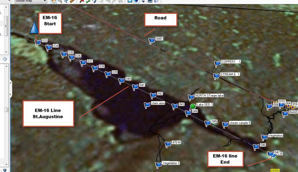
6 Well we had to pack it in and head to the Crooks Lake Depot to use the phone and Call John Clarke or Glenn Penny, did not reach them so Cameron called Gerry Kilfoil and got him we told him what was happening and he had to check to see if the other EM-16 was there to send out to us, there was another EM-16 to send out and would be shipped to Goose Bay that evening for pickup. Wednesday morning we drove to Goose Bay to pick up the EM went to freight office at PAL Airlines and no EM. We waited for the next plane to arrive from St. John s and still no EM. To make a long story shorter the EM -16 did not Arrive until Saturday March 23 rd midday Did contact Government office A few times but who ever shipped the EM to Goose Bay on Tuesday evening never shipped it priority post and only regular cargo. Was not impressed, but oh well, Got back to Claim area in Crooks Lake about 2 pm. Got to work right way did a partial line on the 23 rd got to late too finish it that day. Finished the line on the next day. A total of 2.4km line. see EM-16 line # 11 in attached report for EM in this area. The pond or steady in the claim was explored in early June, 2013 looking for outcrop around the pond. A canoe was used to travel the area, did spend time digging for rock only to find overburden, not sure how far down rock would be down, dug several test holes. Total of two days Jeff Martin and Cameron Martin. Conclusions and Recommendations There is little traditional prospecting which can be done on this property only a detailed soil sampling. More EM-16 work can be done to help map out the conductors and potential diamond drill targets. I would recommend Air Bourne geophysics on this and surrounding properties. To target drill areas. I do think that this area has potential. I do have some good assay results and also good EM-16 lines which have picked up some great conductors which only more geophysical mapping and drilling could verify the mineralization below. The EM-16 report is attached in a separate file. Respectfully Submitted, Jeffrey Martin

7 Figure 1 Property location Labrador

8 Figure 2 Property Location grid map 13B11

9 Figure 3 Highway and claim Location Beginning at the Northeast corner of the herein described parcel of land, and said corner having UTM coordinates of N, E; of Zone 21; thence South 2,500 metres, thence West 3,000 metres, thence North 1,500 metres, thence West 1,000 metres, thence North 1,000 metres, thence East 4,000 metres to the point of beginning Reserving nevertheless out of the above described area all of the land being part of: Beginning at the Northeast corner of the herein described parcel of land, and said corner having UTM coordinates of N, E; of Zone 21; thence South 1,500 metres, thence West 2,000 metres, thence North 1,500 metres, thence East 2,000 metres to the point of beginning. All bearings are referred to the UTM grid, Zone 21. NAD27.
10 Appendix 1 Personnel Name Residence Daily Rate Activity Work Days Jeffrey Martin Cartwright $ Prospecting 9 Cameron Martin Labrador City $ Prospecting 12 Mike Richards Labrador City $ Prosp./Jr.Geologist 3 $ Report prep 1 Total $ Contractors During this reporting period no outside contractors were used
11 Appendix 2 Statement of Expenditures Gas $ Truck $ Snowmobile $ Canoe $80.00 Tent / Cabin $ Food $ TOTAL $
12
13
14 Geological / Geophysical Interpretation and Economic Potential of the Crooks Lake Prospect Development Revised / Edited May 7 th, 2013
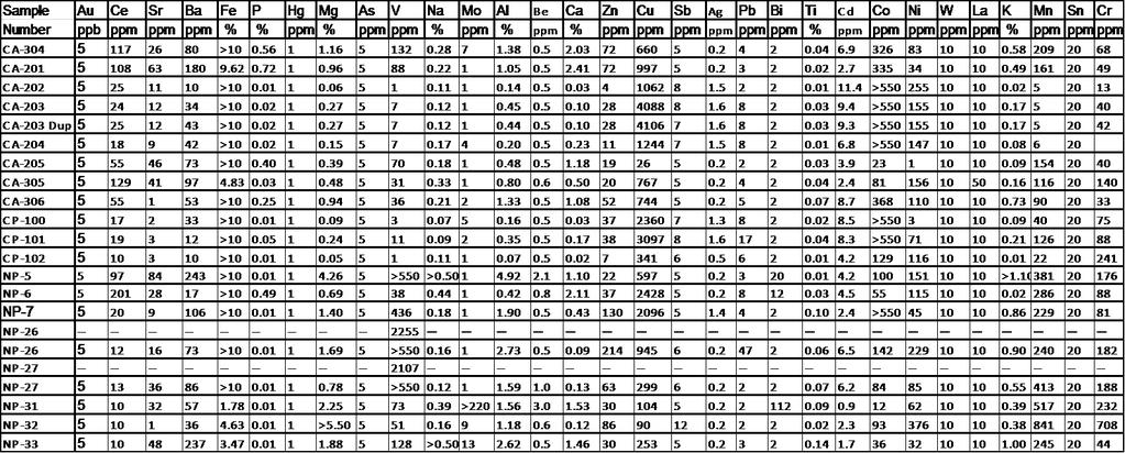
15 Geological Setting Occurring within the Grenville geological province, this property consists dominantly of two contrasting magmatic bodies, intimately associated with one another throughout the region: syenite pegmatite and fine-coarse grained, banded granodiorite. It is known that the area has a very complex geological history, with many generations of faulting, folding and intermittent injection of younger material through pre-existing fracture systems. Cross cutting the claims appears to be a large fault system, along which several magmatic plutons have been injected upward (See figure 1). Within our claims areas, Pyrite and Cobalt sulphide are the principal ore hosting minerals. Our best grab sample assay results indicate Cu Values of over ppm, and Cobalt values above the upper detection limit for the analysis type (See Assays). Having two separate sulphides found in such close proximity to one another gives us reason to believe that a nearby heat source (such as a near to surface pluton) with conduits by which to effectively transfer heat and volatiles into the surrounding two types country rock has yielded a different sulphide from each rock type. Sulphides in many showings are found locally in massive forms following fracture systems Identified at surface, as well as with EM-16 crossover data at depth. Disseminated sulphides are found quite commonly throughout the area. Data Acquisition In order to establish a baseline geological knowledge of the area, the Newfoundland and Labrador Geological survey website was consulted for basic geological information of the area. After receiving promising assay values from the first round of grab samples, further investigation into several areas surrounding the open pit aggregate operations was commenced. Upon completion, more showing and greater sulphide values were found for both cobalt and copper. On Sept 17 th 2012, a full day of field mapping was to take place. However, upon traversing the unforgiving terrain in the area, we returned to the camp finding zero outcrop: The land virtually in its entirety has little to no outcrop due to ~6m+ thick soil and till horizons. Digging commenced in a number of locations but we had never reached bedrock once. We decided to focus our efforts on areas where we knew there were outcrop, and to better understand the fracture system in the area. While many geological measurements were taken, the complexity of the system overwhelmed the usefulness of such interpretation given the lack of regional data. It was then decided that in order to further develop the prospecting site that geophysical means must be employed. An EM-16 was employed to induce a current within near surface sulphide bodies (up to a depth of approximately 10m). The pits were walked over areas where showings had been visibly seen, to gauge the size of the bodies at depth. Identifiable crossover points had been noted in two areas, but may have only been apparent as the lines were walked parallel to the direction of the incoming signal. The second time in the field (Oct.1 st ), three more EM lines were traversed, each supplying their own crossover values (See board images for crossover values and imaging).
16 More effort was taken to walk as perpendicular as possible to the incoming signal to have greater detection. Results Within one of our major pits, foliations were found running off in many directions, appearing to have been derived from mylonitic fault zones. Quartz veining is found throughout all rock types and cross- cuts virtually all boundaries (this is further evidence to supplement our interpretation of a volatile rich heat source being the cause of mineralization in the area). Veins of massive chalcopyrite appear to be 2-3cm thick throughout the pits. Syenite pegmatites are found to be cross cutting some (generations) of quartz veining, and quartz overprints all material in some other areas. This gives us reason to believe there were multiple stages of volatile injection that may be responsible for the separate sulphide types. We believe that the country rock was first subjected to intrusion of the granitic pegmatite, and then possibly one stage of volatile input (smaller scale). The faulting and folding occurred on a wide scale causing greater uplift of plutons at depth, causing a much larger scale injection of hydrothermal fluids into the area. More than one stage of faulting may have occurred as well, post-fluid injection. Vast amounts of folding evidence were found: some boulders have evidence of 3-4 generations of folding, probably more given the complexity of the area. Primary folding may not even be visible; all that is certain is that the area has gone through a great deal of alteration both physically and chemically, to create an atmosphere suitable for sulphide mineralization. Summary Showings of massive chalcopyrite and cobalt sulphide (Linnaeite?) have been found at surface visibly, and inferred at depth by utilization of geophysical means. Mapping of fracture patterns and foliations was attempted at both pit locations, however the complexity of the rocks due to heavy alteration in the area made for the results to be of little use. Efforts to find more visible outcrop across the entire claims area proved to be of no use due to the swamp like environment caused from impermeable till holding water at the surface, as well as having very thick A, B soil horizons. Rivers and streams were walked as well, but the sourcing of the loose rocks came from areas unknown and outcrop was not showing any mineralization. Regional gravimetric surveys show magnetic highs form along a lineation, and also form a boundary at which the regional texture appears to have a distinct change (regional highs to the southeast (greens / reds), and regional lows to the northwest (blue)). This data has given us the assumption that we may be within a large scale regional fault system containing structurally controlled plutonic bodies, and therefore may host mineralization along secondary and tertiary fractures in the area.


17 Images Area claims shown on top of regional Aeromagnetic survey data, Claims are semi-transparent blue polygons. Image rotated so proposed fault trend is running N-S. Fault actually appears to be running NE-SW through southern Labrador.


18 Syenite shown cross cutting pre-existing beds of granodiorite and smaller dykes of pegmatite. Smaller dykes exhibit chill margins. Shows several syenite intrusion events which would have intermittently heated the region. Evidence of syenite cross-cutting both granodiorite and small quartz veins (which overprint virtually everything) May imply more than one intrusion event for the pegmatite.
 as")

19 Red field book is sitting in front of large mineralized granodioritic gouge zone. Mineralization is found both in the pegmatite below (M-shaped body to the left) as well as in the above granodiorite. Evidence of large scale regional relationship between pink syenite pegmatite and granodiorite gneiss bodies. Red field book for scale.

20 Folding complexity of the area is shown within a syenite pegmatitic boulder as a prime example. Here, two perpendicular generations of folding are easily spotted. In the field, two more fold generations are visible from different angles. Measuring tape as scale.

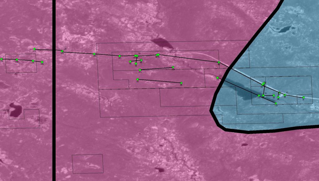
21 With measuring tape as scale, here is a cluster of mineralized gneissic chalcopyrite boulders within the westernmost pit. It is common to see this much mineralization in boulders in the area. Geophysics Data A Number of VLF-EM traversal lines had been planned across areas of interest throughout the Crooks Lake property. An EM-16 apparatus was used to map the subsurface resistance and therefore mineralization potential. The coordinate system used to record this data is UTM NAD27. Below is a map of the claims area with the traversal lines, followed by graphs of the results. Graphed representations all proceed from point A to point B. According to the natural resources website, Light blue is syenite and pink is granodiorite gneiss. Primary conductors are believed to be Cu-Ni sulphides, pyrite, calcopyrite and pentlandite.
22
23 Geochemical Data
24 The following was sent to us by a government representative geologist after looking over / analyzing our data for the Crooks Lake prospect. Very interesting property. You seem to have quite a range of variation. The MODS description says it is a pegmatite within gabbro or metagabbro. Cobalt mineralization is much less common than copper, so it is rare to see rocks with higher cobalt than copper. In the Voiseys Bay deposit, the average grade of Co is about 0.09% or 1/10th as much as yours. There, the Co is tied up with the Ni in pentlandite, whereas yours seems to be associated with the Cu in calcopyrite(?) and you have very little nickel (comparatively). The other mineralization to the west at "New Pit" seems to be a much different beast. It seems to be relatively low in Cu, & much higher in Mn, Cr, & Va. Still sulphides, but not the same mineralization at all. One would assume that the host rock here would have a different & probably an ultramafic - these two mineral occurrences could be from the same mineralizing system, just that the host rock chemistry is different, causing different minerals to form in the 2 environments.. In a sense, you have already done good work by EM-16 surveying - you have shown that there is EM conductivity associated with the mineralized zone at Crooks Lake. This means that an airborne EM (& mag) survey could potentially detect extensions of this area and maybe identify many other potential targets. Your Line 1 at New Pit also defines a nice little EM conductor. Here, however, the VLF profile is asymmetric - the positive peak is much less than the negative peak, but the crossover is well-defined at about 575 to 580 along this line. If this is the site of mineralization here, that is very good news also. It confirms that both mineralization styles are detectable by EM surveys. Here the asymmetric shape of the profile would suggest that the conductor is not vertical, but is dipping to the East. Your line 3 at New Pit is also interesting and seems to be showing either a wide conductor or 2 closely spaced conductors, located at about 360 and 675 m on this profile. The president of the prospectors association also had this to say about the review and data on the property, additionally: I reviewed Gerry Kilfoil's summary and he makes some very interesting observations and technical guidance. No doubt more work needs to be done on this promising property. The massive and breccia type mineralization in the photos looks quite interesting and could be coming off a much larger massive sulphide deposit in fractures, lenses and breccia containing fragments of quartz, or feldspar and other pegmatitic or intrusive hosts.
A GUIDE TO WRITING AN ASSESSMENT REPORT ON YOUR CLAIMS
 A GUIDE TO WRITING AN ASSESSMENT REPORT ON YOUR CLAIMS PLEASE NOTE! In the following pages, suggestions and advice are in italics, under each heading. Use as a guideline only. Items in bold should be changed
First Year assessment Report on Prospecting and Rock sampling, King George property, License M NTS 12A/05 Newfoundland and Labrador.
 First Year assessment Report on Prospecting and Rock sampling, King George property, License 016679M NTS 12A/05 Newfoundland and Labrador. Submitted by Shawn Rose For Shawn Rose January 2011 Work year
SECOND and THIRD YEAR ASSESSMENT REPORT PROSPECTING LICENCE M, ROCK CUT PROPERTY, NTS 1N/12, NEWFOUNDLAND. ROY FRENCH (licence holder )
") SECOND and THIRD YEAR ASSESSMENT REPORT Of PROSPECTING On LICENCE 013704M, ROCK CUT PROPERTY, NTS 1N/12, NEWFOUNDLAND. By ROY FRENCH (licence holder ) Work Conducted: Sept. 17, 2008 Nov. 03, 2009 Total
SECOND and THIRD YEAR ASSESSMENT REPORT Of PROSPECTING On LICENCE 013704M, ROCK CUT PROPERTY, NTS 1N/12, NEWFOUNDLAND. By ROY FRENCH (licence holder ) Work Conducted: Sept. 17, 2008 Nov. 03, 2009 Total
FIRST YEAR ASSESSMENT REPORT PROSPECTING LICENCE 16512M MARYSTOWN AREA, BURIN PENINSULA NTS 1M/3
 FIRST YEAR ASSESSMENT REPORT OF PROSPECTING ON LICENCE 16512M MARYSTOWN AREA, BURIN PENINSULA NTS 1M/3 BY NATHANIEL NOEL MSc. FOR E. MICHELE NOEL MINERAL LICENCES: 16512 M WORK CONDUCTED: MID-SEPTEMBER
%+ '$# $) %, %*$ " $ $ ' %' !()'-!" %( %"%! " *'+ - % %$! $)! " $)!" !$ ' "! )( ! $ '%& ')- % % "!#( (( ((# $) ' ) ((* & *# ' % %"*# ( !!
 %, %*$ $ $ ' %' !()'-! %( %%! *'+ - % %$! $)! $)! !$ ' ! )( ! $ '%& ')- % % !#( (( ((# $) ' ) ((* & *# ' % %*# ( !!") 001L/14/0218 First Year Assessment Report of Prospecting, Rock and Stream Sediment Sampling On Licence 18880M, NTS 1L/14 Burin Peninsula Newfoundland and Labrador Submitted by: Keith Kelloway Work year:
001L/14/0218 First Year Assessment Report of Prospecting, Rock and Stream Sediment Sampling On Licence 18880M, NTS 1L/14 Burin Peninsula Newfoundland and Labrador Submitted by: Keith Kelloway Work year:
DÉCOUVERTE Positioned for Discovery in James Bay, Quebec. Investor Presentation, January 2018 by Danae Voormeij, MSc, PGeo
 DÉCOUVERTE Positioned for Discovery in James Bay, Quebec Investor Presentation, January 2018 by Danae Voormeij, MSc, PGeo Location Maps and Infrastructure Location: Durango Resources 100% owned Découverte
REPORT ON DIAMOND DRILLING SUBSTITUTION EAST PROPERTY CLAIMS AND HEBERT TOWNSHIP ONTARIO, CANADA
 REPORT ON DIAMOND DRILLING SUBSTITUTION EAST PROPERTY CLAIMS 1248920 AND 1248921 HEBERT TOWNSHIP ONTARIO, CANADA Adroit Resources Inc. Suite #610-1111 Melville Street Vancouver, British Columbia, Canada
Drilling Program Commences on Iron Oxide Copper Gold Targets
 3 June 2008 Manager Company Announcements Company Announcements Office Australian Stock Exchange Limited Level 10, 20 Bond Street SYDNEY NSW 2000 ABN 42 082 593 235 Electronic delivery No of pages: 6 Drilling
ASX / MEDIA RELEASE 6 MAY MILE SILVER-LEAD-ZINC DISCOVERY; HIGH GRADE SILVER-GOLD IN ROCK CHIPS AT RUBY SILVER
 ASX / MEDIA RELEASE 6 MAY 2011 4-MILE SILVER-LEAD-ZINC DISCOVERY; HIGH GRADE SILVER-GOLD IN ROCK CHIPS AT RUBY SILVER Highlights: Silver-lead-zinc discovery at 4-Mile; mineralisation intersected in all
RESULTS OF OPERATIONS Semi Annual Exploration Report BANLUNG EXPLORATION LICENSE, CAMBODIA FOR THE PERIOD 2015:06:30 TO 2015:12:31
 RESULTS OF OPERATIONS BANLUNG EXPLORATION LICENSE, CAMBODIA FOR THE PERIOD 2015:06:30 TO 2015:12:31 Introduction Work over the period has included the completion of a detailed induced polarization geophysical
CONTENTS. Location, Access and History...6. Tenure Status and Geology Regional Andy Property Geology Map...9
 TYPE OFWORK IN THIS REPORT EXTENT OF WORK (rn METRTC UNITS) ON WHICH CLAIMS PROJECT COSTS APPORTIONED (incl. support) GEOLOGICAL (scale, area) Ground, mapping Photo interpretation GEOPHYSICAL (line-kilometres)
SIMUKU DRILLING TO OVER 1000 METRES DEMONSTRATES SIGNIFICANTLY INCREASED TONNAGE POTENTIAL OF THE INFERRED RESOURCE
 ADDRESS PHONE PO Box 6965 +61(07) 5592 1001 Gold Coast Mail Centre FAX Qld 9726 Australia +61 (07) 5592 1011 EMAIL ABN 54 126 490 855 info@coppermoly.com.au WEBSITE www.coppermoly.com.au ASX Announcement
First Year Assessment Report: Report on Prospecting, Rock and Soil Sampling Carried Out From September/2012 to December/2012.
 First Year Assessment Report: Report on Prospecting, Rock and Soil Sampling Carried Out From September/2012 to December/2012 on the Clarkes Pond Property Licence 020334M Northwest Gander River,Central
The Cobalt Rainbow. Airborne geophysical maps show that a north trending aeromagnetic high suggests further undiscovered mineralisation.
 The Cobalt Rainbow The property is located on Greenstone Creek, approximately 4.8 kilometres south west of the creek mouth. The property is located about 24 km due west of Campbell River, in the east-central
CHAMPION IRON REPORTS EXPLORATION RESULTS AT POWDERHORN PROJECT, NEWFOUNDLAND
 PRESS RELEASE CHAMPION IRON REPORTS EXPLORATION RESULTS AT POWDERHORN PROJECT, NEWFOUNDLAND Confirmed Continuity of High-Grade Zinc Zone and Addition of Gold to the Expanded Copper Zone Montreal, March
ASX Announcement. 28 January Drill results indicate large Porphyry Copper Gold System at Peenam
 ASX Announcement 28 January 2010 Drill results indicate large Porphyry Copper Gold System at Peenam Highlights: 270 metres of visible copper (gold) mineralisation in first diamond core hole at Peenam Prospect
CHAMPION BEAR RESOURCES
 CHAMPION BEAR RESOURCES EXPLORING ADVANCED STAGE PRECIOUS METAL PROPERTIES IN ONTARIO Exploration Update January 2011 Forward Looking Statements This exploration update contains forward looking statements
Alligator commences drilling of TCC4 uranium prospect in Arnhem Land, NT 4 September 2018
 Alligator commences drilling of TCC4 uranium prospect in Arnhem Land, NT 4 September 2018 Highlights The TCC4 prospect represents Alligators most advanced untested undercover uranium target with a large
ASSESSMENT REPORT PROSPECTING PROGRAM ION/DIRTY JACK PROPERTY NELSON MINING DIVISION N.T.S. MAP SHEET 82F.023 UTM COORDINATES N E
 ASSESSMENT REPORT PROSPECTING PROGRAM ION/DIRTY JACK PROPERTY NELSON MINING DIVISION N.T.S. MAP SHEET 82F.023 UTM COORDINATES 5454800N - 0455235E Work Performed Summer 2007 OWNER >* ' Tom Kennedy >8 404-22
For personal use only
 21 December 2017 MASSIVE SULPHIDES INTERSECTED IN DRILLING 15 hole, 2270m diamond drill program completed at Midrim Thick zones of massive sulphides intersected Core being logged and sampled with assays
The MAPLE BAY PROJECT Copper Silver - Gold
 The MAPLE BAY PROJECT Copper Silver - Gold Good grade and tonnage potential within close proximity to Tidewater The Maple Bay Copper Silver Gold Project covers highly favourable geological host rocks of
Saskatchewan s Mineral Resources Lesson: Exploring for Minerals in Saskatchewan: Stream Sediment and Soil Sampling
 Saskatchewan s Mineral Resources Lesson: Exploring for Minerals in Saskatchewan: Stream Sediment and Soil Sampling Overview In this activity, students use information from geochemical surveys (stream sediment
Golden Cross Resources
 Golden Cross Resources Labrador Uranium Joint Venture with Altius Resources Update - November 2007 Labrador Uranium - Canada LABRADOR URANIUM PROPERTIES Golden Cross Resources signed an agreement with
FIRST 2 DRILL HOLES AT NAKRU-2 PROSPECT BOTH INTERSECT SIGNIFICANT HIGHER GRADE COPPER MINERALISATION
 ADDRESS PHONE PO Box 6965 +61(07) 5592 1001 Gold Coast Mail Centre FAX Qld 9726 Australia +61 (07) 5592 1011 EMAIL ABN 54 126 490 855 info@coppermoly.com.au WEBSITE www.coppermoly.com.au ASX Announcement
BLURTON CREEK NICKEL PROPERTY. (Minfile # 082LNW-039)
") 5489153 BLURTON CREEK NICKEL PROPERTY (Minfile # 082LNW-039) Mara Lake Area / Salmon Arm B.C NTS - 82L-11 (UTM 83/Z10, 357690E, 5614220N) Prepared by: Jim Cuttle, B.Sc., P.Geo. 86 Cloudburst Road Whistler,
5489153 BLURTON CREEK NICKEL PROPERTY (Minfile # 082LNW-039) Mara Lake Area / Salmon Arm B.C NTS - 82L-11 (UTM 83/Z10, 357690E, 5614220N) Prepared by: Jim Cuttle, B.Sc., P.Geo. 86 Cloudburst Road Whistler,
COPPERSTONE RESOURCES AB INTERCEPTS ZONE OF CHALCOPYRITE-ARSENOPYRITE- BORNITE MINERALIZATION AT SVARTLIDEN IN FIRST DEEP DRILLHOLE FROM 720m-810m
 COPPERSTONE RESOURCES AB INTERCEPTS ZONE OF CHALCOPYRITE-ARSENOPYRITE- BORNITE MINERALIZATION AT SVARTLIDEN IN FIRST DEEP DRILLHOLE FROM 720m-810m In mid-january 2017 Copperstone Resource published a geological
Magnetic Field and VLF Surveys on the Shining Tree Property. Claims: , , , , , , , ,
 December 29, 2014 NTS: 041P11 Magnetic Field and VLF Surveys on the Shining Tree Property Claims: 1203361, 4251801, 4251803, 4251805, 4263067, 4263068, 4270940, 4270436, 4276740 Churchill and Asquith Townships
State Metallic Minerals Lease Sale Minnesota s Vermilion Gold District
 State Metallic Minerals Lease Sale Minnesota s Vermilion Gold District State Metallic Minerals Lease Sale Notice of Intent Scale 1:100,000 State Metallic Minerals Lease Sale This portion of the lease sale
For personal use only
 ASX ANNOUNCEMENT 17 May 2013 Exploration update for the Kagera Nickel Project Kibaran Resources Limited (ASX: KNL) is pleased to provide an update of the nickel sulphide (NiS) study being undertaken on
NEWS RELEASE FOR IMMEDIATE RELEASE: MARCH 5, 2018
 NEWS RELEASE FOR IMMEDIATE RELEASE: MARCH 5, 2018 Eskay Mining provides update on ongoing geological review - Targeting E&L-Type Nickel-Copper-PGE and Eskay-Type VMS Potential on Its Golden Triangle Holdings:
Report. Mining Claim SO Butt Township. District of Nipissing. Southern Ontario Mining District. Richard Keevil ~ Geologist. August 29,2006.
 Report On Mining Claim SO 1077365 Butt Township District of Nipissing Southern Ontario Mining District ~ "'_I ""'..1 D I..:"'.U&O... ~u ~]. Richard Keevil ~ Geologist August 29,2006. Richard R. Keevil,
POTENTIAL OF THE DONGWE COPPER GOLD PROJECT
 POTENTIAL OF THE DONGWE COPPER GOLD PROJECT By Nathan Sabao, P.Geo. September 2015 1 TABLE OF CONTENTS Page 1.0 EXECUTIVE SUMMARY 1 2.0 LOCATION 2 3.0 ACCESS 2 4.0 GEOLOGY 3 5.0 PREVIOUS DRILLING 5 6.0
Gungnir Resources Inc.
 Gungnir Confirms Near-Surface Gold Mineralization and Drills New Copper- Nickel Bearing Sulphides at Knaften in Sweden Vancouver October 23, 2017 - Gungnir Resources Inc. (GUG: TSX-V, ) ( Gungnir or the
Montgomery Bedrock Geology 21d-Gowganda Formation: conglomerate, sandstone, siltstone, argillite
 Work Report 2014 Trenching Montgomery Township G-3303 Claim #4259384,4245818 Sault Ste. Marie Mining Division Michael & Yvon Gagne Montgomery Copper Property 1 P a g e 2 P a g e Montgomery Bedrock Geology
ANTLER GOLD DRILLS GRAMS PER TONNE GOLD OVER 5.35 METRES AT THE WILDING LAKE GOLD PROJECT, NEWFOUNDLAND
 ANTLER GOLD DRILLS 10.01 GRAMS PER TONNE GOLD OVER 5.35 METRES AT THE WILDING LAKE GOLD PROJECT, NEWFOUNDLAND HALIFAX, NOVA SCOTIA (CNW December 13 th, 2017) Antler Gold Inc. ( Antler ) (TSX- V:ANTL) is
12 tons of high-grade ore was mined from the No. 1 vein with an average grade of 13 g/t gold, 3,250 g/t silver and 23.3% lead.
 DUNWELL MINE GROUP The Dunwell Mine Group (Dunwell, Dunwell East, Bear River/MM and Silvershot properties), which includes the historic, past-producing Dunwell mine, is located 8 km northeast of Stewart
Acquisition of Kilfoyle Project, Northern Territory
 ASX Announcement 31 May 2018 Level 1, 135 Fullarton Road Rose Park, SA 5067 Australia Telephone +61 (0) 8 8364 3188 Facsimile +61 (0) 8 8364 4288 info@pnxmetals.com.au www.pnxmetals.com.au Acquisition
TSX-V: NRN. Shot Rock Gold Property,
 Shot Rock Gold Property, Nova Scotia August, 2018 This document contains statements concerning the potential for PGE, Ni-Cu, Gold and other mineralization at Huckleberry, Shot Rock and Five Islands; geological,
Summary of Rover Metals Geologic Mapping Program at the Up Town Gold Project, Northwest Territories
 October 13, 2017 Summary of Rover Metals Geologic Mapping Program at the Up Town Gold Project, Northwest Territories Vancouver, British Columbia, Canada - Rover Metals Corp., Rover, is pleased to provide
Large Epithermal Quartz Veins Found in Outcrop at Shot Rock, Nova Scotia; Dozens of Large Angular Boulders Suggest Extensive System
 Large Epithermal Quartz Veins Found in Outcrop at Shot Rock, Nova Scotia; Dozens of Large Angular Boulders Suggest Extensive System Ottawa, Ontario (November 7, 2018) - Northern Shield Resources Inc. ("Northern
GEOPHYSICAL SURVEYING COMMENCES AT ESK TROUGH
 ADDRESS PHONE PO Box 6965 +61(07) 5592 1001 Gold Coast Mail Centre FAX Qld 9726 Australia +61 (07) 5592 1011 EMAIL ABN 54 126 490 855 info@coppermoly.com.au WEBSITE www.coppermoly.com.au ASX Announcement
Spruce Ridge Resources Ltd Leslie Road West, Puslinch, ON N0B 2J0 Telephone: (519) , Fax: (519)
 , Fax: (519)") Spruce Ridge Resources Ltd. 7735 Leslie Road West, Puslinch, ON N0B 2J0 Telephone: (519) 822-5904, Fax: (519) 823-5090 PRESS RELEASE 2018-07 July 24, 2018 Spruce Ridge Resources Provides Update on the
Spruce Ridge Resources Ltd. 7735 Leslie Road West, Puslinch, ON N0B 2J0 Telephone: (519) 822-5904, Fax: (519) 823-5090 PRESS RELEASE 2018-07 July 24, 2018 Spruce Ridge Resources Provides Update on the
GEOLOGICAL MAPPING REPORT ON THE ASH MINERAL CLAIM OSOYOOS MINING DIVISION ASHNOLA RIVER MAP SHEET NTS M092,H019 MCBRIDE CREEK AREA, ASHNOLA RIVER,
 GEOLOGICAL MAPPING REPORT ON THE ASH MINERAL CLAIM OSOYOOS MINING DIVISION ASHNOLA RIVER MAP SHEET NTS M092,H019 LATITUDE 49 o O6, LONGITUDE 120 o 22 MCBRIDE CREEK AREA, ASHNOLA RIVER, KEREMEOS, B.C. CANADA
PROSPECTORS ASSISTANCE PROGRAM MINISTRY OF ENERGY AND MINES
 BRITISH COLUMBIA PROSPECTORS ASSISTANCE PROGRAM MINISTRY OF ENERGY AND MINES GEOLOGICAL SURVEY BRANCH PROGRAM YEAR: 1999/2000 REPORT #: PAP 99-l 6 NAME: KIM ANSCHETZ PROSPECTORS TlEPORT on the 99 LOUIS
NEWS RELEASE CANADIAN ZINC REPORTS REMAINING DRILL RESULTS AT LEMARCHANT DEPOSIT, SOUTH TALLY POND PROJECT, NEWFOUNDLAND
 NEWS RELEASE CZN-TSX CZICF-OTCQB FOR IMMEDIATE RELEASE March 5, 2018 CANADIAN ZINC REPORTS REMAINING DRILL RESULTS AT LEMARCHANT DEPOSIT, SOUTH TALLY POND PROJECT, NEWFOUNDLAND 2017 drill program successfully
Voisey s Bay South Nickel-Copper Project
 Voisey s Bay South Nickel-Copper Project Robert Freidland is back exploring in Labrador Project Overview - Vulcan Minerals Inc. owns 100% of 4 strategically located licences within the Voisey s Bay South
Compilation Report Hawke Hill South. Licence No M NTS 01N/06. Newfoundland and Labrador. Submitted by Gordon E. Cooper and Kevin P.
 Compilation Report 2010 Hawke Hill South Licence No. 017282M NTS 01N/06 Newfoundland and Labrador Submitted by Gordon E. Cooper and Kevin P. Ryan For Kevin P. Ryan (Licence holder) January, 2011 Work Year:
Gold Mountain Group Gold Mtn. A, B, C & D Mineral Claims Record Nos. 697, 698, 699 & 700. Island Mountain Cariboo Mining Division British Columbia
 GOLD POINT RESOURCES LTD. Geophysical Survey Gold Mountain Group Gold Mtn. A, B, C & D Mineral Claims Record Nos. 697, 698, 699 & 700 Island Mountain Cariboo Mining Division British Columbia Vancouver,
Encouraging drill results from Paroo Range
 17 July 2012 The Manager ASX Company Announcements Office PO Box H224, Australia Square SYDNEY NSW 2001 Encouraging drill results from Paroo Range Highlights Significant uranium mineralisation at the 100%
Exploration Program planned at White Rock s Red Mountain zinc project in Alaska
 ASX and Media Release: 18 December 2017 ASX Code: WRM Exploration Program planned at White Rock s Red Mountain zinc project in Alaska ASX Code: WRM Issued Securities Shares: 907.7 million Options: 206.9
DRIVING NICKEL AND COPPER SULPHIDE DISCOVERY ON THE FRASER RANGE
 INVESTOR UPDATE DRIVING NICKEL AND COPPER SULPHIDE DISCOVERY ON THE FRASER RANGE JUNE 2014 Disclaimer The information in this presentation is published to inform you about Classic Minerals Limited and
For personal use only
 ASX ANNOUNCEMENT 31 August 2012 DRILLING SUCCESS CONTINUES AT GUCHAB Near surface copper mineralisation in drill core from GCDD0002 HIGHLIGHTS The pilot programme of diamond drilling at Guchab continues
We are committed to providing accessible customer service. If you need accessible formats or communications supports, please contact us.
 We are committed to providing accessible customer service. If you need accessible formats or communications supports, please contact us. Nous tenons à améliorer l accessibilité des services à la clientèle.
ASSESSMENT REPORT ON THE PEAVINE PROJECT. DGW & Associates # Alberni Street, Vancouver, British Columbia, V6E 4V2
 ASSESSMENT REPORT ON THE PEAVINE PROJECT KAMLOOPS MINING DIVISION BRITISH COLUMBIA NTS 082M 12 Latitude 51 36' 19.0"North -- Longitude --119 47' 27.0"West UTM Zone 11, NAD 83 5720827N 306744E Prepared
West Georgia Street, Vancouver, BC, V6E 3V7 Phone: / Fax: NEWS RELEASE October 11, 2017
 1305 1090 West Georgia Street, Vancouver, BC, V6E 3V7 Phone: +1 604 685 9316 / Fax: +1 604 683 1585 NEWS RELEASE October 11, 2017 MAWSON DISCOVERS NEW HIGH-GRADE GOLD IN MULTIPLE OUTCROPS AT EAST ROMPAS
LOS AZULES April 2018
 April 2018 lies along the southern extensions of the highly productive Paleocene Mineral Belt in northern Chile that contains numerous important copper, gold and silver mines and projects, and to the south
For personal use only
 ACN 097 088 689 ASX Announcement 1 EXPLORATION SUCCESS CONTINUES AT RAVENSWOOD RC drilling targeting shallow portions of Welcome breccia returns a number of significant new results including: 7m @ 7.84g/t
NT RESOURCES LIMITED QUARTERLY ACTIVITIES REPORT FOR THE PERIOD ENDED 30 JUNE 2010 ASX CODE: NTR
 NT RESOURCES LIMITED QUARTERLY ACTIVITIES REPORT FOR THE PERIOD ENDED 30 JUNE 2010 ASX CODE: NTR Activities Report Background NT Resources Limited ( NT Resources or the Company ) holds six granted Exploration
Nachicapau Zn-Cu project THE NEXT MAJOR DISCOVERER IN QUEBEC
 Nachicapau Zn-Cu project THE NEXT MAJOR DISCOVERER IN QUEBEC Nachicapau Project - Location Willbob & Pallas Projects Kuujjuaq Located about 150km south of Kuujjuaq, the closest community (has a port) 215
For personal use only
 ASX ANNOUNCEMENT 6th February 2012 HIGH GRADE AU-CU INTERSECTIONS FROM KUINI PROSPECT IN ACEH ASX: PSP SHARE INFORMATION Issued Shares: 346.54m Unlisted Options: 20.95m BOARD OF DIRECTORS Chairman & MD:
The McPhillamys Gold Deposit, Discovery History & Geology. Presenter: Tara French
 The McPhillamys Gold Deposit, Discovery History & Geology. Presenter: Tara French Forward-Looking Statements This presentation contains forward-looking statements. without limitation: Estimates of future
VR DISCOVERS PORPHYRY COPPER MINERAL SYSTEM AT ITS JUNCTION PROPERTY, NEVADA; EXPLORATION ADVANCES.
 NR-19-01 VR DISCOVERS PORPHYRY COPPER MINERAL SYSTEM AT ITS JUNCTION PROPERTY, NEVADA; EXPLORATION ADVANCES. January 29, 2019, Vancouver, B.C.: VR Resources Ltd. (TSX.V: VRR, FSE: 5VR; OTCBB: VRRCF), the
SQUARE POST PROJECT CHARTERS TOWERS NORTH QUEENSLAND AUSTRALIA
 SQUARE POST PROJECT CHARTERS TOWERS NORTH QUEENSLAND AUSTRALIA Square Post - Summary PROJECT DETAILS - SQUARE POST The Square Post exploration permit (EPM 18510) contains two styles of mineralisation:
Magnus Copper Project exploration update
 ASX ANNOUNCEMENT 30 SEPTEMBER 2011 CODE: ALY BOARD OF DIRECTORS Mr Warwick Davies Non-Executive Chairman Mr Robert Brierley Managing Director Mr John Arbuckle Non-Executive Director Mr Jeffrey Moore Non-Executive
For personal use only
 10 July 2012 Encouraging New Gold Results from Gunung Rosa Drilling Highlights Assay results from three drill holes at depth under the Cap Palu section confirm significantly wider intercepts of gold-copper-base
Carrapateena Mineral Resources Explanatory Notes April OZ Minerals Limited. Carrapateena Mineral Resources Statement April
 OZ Minerals Limited Carrapateena Mineral Resources Statement April 14 2011 CARRAPATEENA MINERAL RESOURCE STATEMENT April 14, 2011 The Carrapateena Resource Statement relates to an upgrading to an Inferred
3. GEOLOGY. 3.1 Introduction. 3.2 Results and Discussion Regional Geology Surficial Geology Mine Study Area
 3. GEOLOGY 3.1 Introduction This chapter discusses the baseline study of the geology and mineralization characteristics of the mine study area. The study consolidates existing geological data and exploration
Summary and status of the Reinfjord Exploration Project and other exploration targets within the Seiland Igneous Province
 Summary and status of the Reinfjord Exploration Project and other exploration targets within the Seiland Igneous Province By Nordic Mining s Exploration Manager Mona Schanche, 1 st of August 2013 Background
Drill locations for the 2015 program are highlighted in the geology map below.
 2015 Exploration Program The exploration program plan at KSM for 2015 was designed to improve the understanding of block cave targets and support engineering/environmental aspects of development scenarios.
FIRST YEAR ASSESSMENT REPORT ON THE HAMMERDOWN SOUTH PROPERTY KING S POINT AREA, NEWFOUNDLAND
 FIRST YEAR ASSESSMENT REPORT ON THE HAMMERDOWN SOUTH PROPERTY KING S POINT AREA, NEWFOUNDLAND Licenses: 017558M, 017559M, 017560M and 017561M NTS Mapsheets: 012H/08 and 012H/09 Garry Fraser 66a Frontenac
Sipa Resources Limited ABN
 Sipa Resources Limited ABN 26 009 448 980 Aims of Diamond Drilling Programme Achieved The copper sulphide chalcopyrite, intersected in each of three holes, at two locations at Enigma: best copper intersection
Total Magnetic Field and VLF Surveys on the Swayze Property. Claim Swayze Township. Porcupine Mining Division
 1 January, 016 NTS: 041 O 15 Total Magnetic Field and VLF Surveys on the Swayze Property Claim 475471 Swayze Township Porcupine Mining Division 380850E, 599450N UTM Z17N NAD83 Report Prepared for: 540
Sotkamo Silver Mo i Rana and Tampere areas. Erkki Kuronen Chief Geologist, M.Sc., MAusIMM Sotkamo Silver Oy
 Mo i Rana and Tampere areas Erkki Kuronen Chief Geologist, M.Sc., MAusIMM Oy Mo i Rana and Tampere areas Erkki Kuronen Chief Geologist, M.Sc., MAusIMM Oy 2.9.2018 Silver 2 Deposits and Projects develops
Canadian National Railways tracks from the foot bridge across the. Thompson River from the Trans Canada Highway. A pick-up truck was used
 Canadian National Railways tracks from the foot bridge across the Thompson River from the Trans Canada Highway. A pick-up truck was used on the highway side and a h-wheel drive Jeep was transported by
CAMBRIDGE NICKEL PROSPECT EXPLORATION UPDATE. XRF analysis of reconnaissance drill holes at Cambridge has been completed
 17 December 2012 CAMBRIDGE NICKEL PROSPECT EXPLORATION UPDATE HIGHLIGHTS XRF analysis of reconnaissance drill holes at Cambridge has been completed Initial geological logging and XRF analysis identifies
Tin Mineralisation. in the Mesoproterozoic Prospect Hill Region, Northern Flinders Ranges: Recent Drilling Results and Suggestions for Regional
 Tin Mineralisation in the Mesoproterozoic Prospect Hill Region, Northern Flinders Ranges: Recent Drilling Results and Suggestions for Regional Tin Exploration in South Australia UNCOVER CURNAMONA 2017
SEPTEMBER QUARTERLY REPORT
 SEPTEMBER QUARTERLY REPORT Resource Mining Corporation Limited ( RMC ) For the period ended 30 th September 2011 HIGHLIGHTS: Resource Mining Corporation Limited ABN: 97 008 045 083 702 Murray Street West
News Release DRILLING STEPPED UP AT FORRESTANIA NICKEL PROJECT AND UPDATE ON DIGGERS SOUTH PRE - FEASIBILITY STUDY
 June 29, 2007 ASX & TSX: WSA News Release DRILLING STEPPED UP AT FORRESTANIA NICKEL PROJECT AND UPDATE ON DIGGERS SOUTH PRE - FEASIBILITY STUDY The Board of Western Areas is pleased to announce that the
NEWS RELEASE. Highlights:
 NEWS RELEASE GT Gold Drills a New High-Grade Gold Discovery at Saddle South; Strong Intercepts in Multiple Holes Including 13.03g/t Au Over 10.67m; Drilling Continuing, More Assays Pending Vancouver, British
Mineral Deposit Report Page 1 OF Geological Survey of Finland
 Mineral Deposit Report Page 1 OF 11 16.02.2018 Vaaralampi Occurence type: occurrence Commodity Rank Total Total production Total resource Importance measure platinum group metal 1 29,76 t 29,76 t Medium
Press Release Azimut and Partners announce Drilling Results from Eleonore South Gold Property, James Bay region, Quebec
 For immediate release December 17, 2018 Symbol: AZM. TSX Venture Press Release Azimut and Partners announce Drilling Results from Eleonore South Gold Property, James Bay region, Quebec Longueuil, Quebec
Forward Looking Statements
 Forward Looking Statements Except for the statements of historical fact contained herein, certain information presented constitutes "forward-looking statements" within the meaning of the United States
We are committed to providing accessible customer service. If you need accessible formats or communications supports, please contact us.
 We are committed to providing accessible customer service. If you need accessible formats or communications supports, please contact us. Nous tenons à améliorer l accessibilité des services à la clientèle.
MOUNT DOROTHY AND ELAINE DOROTHY PROSPECTS UPDATE
 ASX/Media Announcement 20 th September 2010 MOUNT DOROTHY AND ELAINE DOROTHY PROSPECTS UPDATE MT DOROTHY: Phase 2 diamond drilling to commence. ELAINE DOROTHY New copper zone discovered and to be drilled.
ANTLER GOLD EXPLORATION UPDATE, WILDING LAKE GOLD PROJECT, NEWFOUNDLAND
 ANTLER GOLD EXPLORATION UPDATE, WILDING LAKE GOLD PROJECT, NEWFOUNDLAND HALIFAX, NOVA SCOTIA (CNW May 10, 2018) Antler Gold Inc. ( Antler ) (TSX-V:ANTL) is pleased to provide an update on its upcoming
News Release No GOLD AND COPPER MINERALIZATION DISCOVERED DURING PHASE 2 EXPLORATION AT THE MCBRIDE PROPERTY
 November 19, 2018 TSX Venture Exchange Listed Frankfurt Exchange Listed News Release No. 303-2018 GOLD AND COPPER MINERALIZATION DISCOVERED DURING PHASE 2 EXPLORATION AT THE MCBRIDE PROPERTY Vancouver,
Great Atlantic Rock Samples Return up to 5.8 oz. / ton Gold Golden Promise Property in Central Newfoundland
 Great Atlantic Rock Samples Return up to 5.8 oz. / ton Gold Golden Promise Property in Central Newfoundland FOCUSED ON EXPLORING ATLANTIC CANADA (TSXV : GR) (FRA: PH01) VANCOUVER, British Columbia August
Reconnaissance. Of the. Denis mineral claims. Situated at Kilometer 844 of the Alaska Highway. Liard Mining Division. Northeastern British Columbia
 Reconnaissance Of the Denis mineral claims Situated at Kilometer 844 of the Alaska Highway Liard Mining Division Northeastern British Columbia N.T.S. 94M.075 Latitude 59 42 25 Longitude 127 13 12 Field
DSM SYNDICATE DISCOVERS POLYMETALLIC MINERALIZATION WITH TALUS GRAB SAMPLES CONTAINING UP TO PERCENT LEAD AND 18
 DSM SYNDICATE DISCOVERS POLYMETALLIC MINERALIZATION WITH TALUS GRAB SAMPLES CONTAINING UP TO 92.8 GRAMS PER TONNE GOLD, 13,643 GRAMS PER TONNE SILVER, 13.85 PERCENT LEAD AND 18.65 PERCENT COPPER FROM DIFFERENT
ASX Announcement. FLEM survey underway at Henrietta Cobalt Nickel Prospect, Tasmania ASX: AX8 HIGHLIGHTS. Market Data. Board and Management.
 FLEM survey underway at Henrietta Cobalt Nickel Prospect, Tasmania ASX Announcement Market Data ASX Code: AX8 Shares on Issue: 47,620,000 Board and Management Grant Mooney Non-Executive Chairman Andrew
NTS 082F03SW N W U E N
 Prospecting Report JOCELYN CLAIM NTS 082F03SW N49 09 51 W 117 14 04 11U 482906E 5445737N NELSON MINING DIVISION Martin Ross PO Box 323 Salmo BC V0G 1Z0 Jan 31, 2012 PROSPECTING REPORT JOCELYN MINERAL CLAIM
EXPLORATION & DEVELOPMENT
 EXPLORATION & DEVELOPMENT ZINC LEAD SILVER GOLD COPPER PRAIRIE CREEK MINE PERMITTING COMPLETED PRAIRIE CREEK MINE, NORTHWEST TERRITORIES NEWFOUNDLAND PROJECTS www.canadianzinc.com invest@canadianzinc.com
MORE HIGH-GRADE GOLD INTERSECTIONS FROM CITADEL S SHAYBAN PROJECT, SAUDI ARABIA
 Citadel Resource Group Limited ASX Release 7th July 2009 MORE HIGH-GRADE GOLD INTERSECTIONS FROM CITADEL S SHAYBAN PROJECT, SAUDI ARABIA Highlights: LATEST RC IN-FILL AND EXTENSIONAL DRILLING CONTINUES
DISCOVERY OF MINERALISED PORPHYRY & MAGNETITE-COPPER-GOLD AT KAMARANGAN
 MEDUSA MINING LIMITED ABN: 60 099 377 849 Unit 7, 11 Preston Street Como WA 6152 PO Box 860 Canning Bridge WA 6153 Telephone: +618-9367 0601 Facsimile: +618-9367 0602 Email: admin@medusamining.com.au Internet:
Namibia Critical Metals Drilling Confirms Cobalt and Copper Mineralization in First Two Targets at Kunene
 Press Release Namibia Critical Metals Drilling Confirms Cobalt and Copper Mineralization in First Two Targets at Kunene First results received from drilling on DOF Extension and Okanihova Lineament DOF
%+ '$# $) %, %*$ " $ $ ' %' !()'-!" %( %"%! " *'+ - % %$! $)! " $)!" !$ ' "! )( ! $ '%& ')- % % "!#( (( ((# $) ' ) ((* & *# ' % %"*# ( !!
 %, %*$ $ $ ' %' !()'-! %( %%! *'+ - % %$! $)! $)! !$ ' ! )( ! $ '%& ')- % % !#( (( ((# $) ' ) ((* & *# ' % %*# ( !!") 023H/05/0158 Assessment Report 2014 2nd year assessment report on prospecting Lake Sed., rock and soil sampling, Misty lake, property, Labrador. NTS: 23H/05 Licence # 020885M------ 6 Claims Licence # 020991M------
023H/05/0158 Assessment Report 2014 2nd year assessment report on prospecting Lake Sed., rock and soil sampling, Misty lake, property, Labrador. NTS: 23H/05 Licence # 020885M------ 6 Claims Licence # 020991M------
Prospecting Report 'S Office i DB Property, B.C. -J Negro Creek Nelson Mining District NTS 82F.050. Operator: Kootenay Gold Inc.
 . '.' I"' i9 12 Prospecting Report 'S Office i DB Property, B.C. -J Negro Creek Nelson Mining District NTS 82F.050 Operator: Kootenay Gold Inc. Owner: Darlene Lavoie Work Performed Summer of 2007 Report
Project 81. Drill Ready Geophysical Targets & Trends. Timmins-Cochrane Northern Ontario Canada
 Project 81 Drill Ready Geophysical Targets & Trends Timmins-Cochrane Northern Ontario Canada FORWARD-LOOKING STATEMENT Certain statements contained in this presentation that are forwardlooking in nature
Altan Nar. Gold & Base Metal Discovery (Tsenkher Nomin Property) October 12 th, 2011
 October 12 th, 2011") Altan Nar Gold & Base Metal Discovery (Tsenkher Nomin Property) October 12 th, 2011 1 FORWARD-LOOKING STATEMENTS Certain information regarding Erdene ("the Company") contained herein may constitute forward-looking
Altan Nar Gold & Base Metal Discovery (Tsenkher Nomin Property) October 12 th, 2011 1 FORWARD-LOOKING STATEMENTS Certain information regarding Erdene ("the Company") contained herein may constitute forward-looking
ASX Code: ORN Compelling Nickel-Copper Targets Defined at Fraser Range Project
 ASX Code: ORN www.oriongold.com.au Compelling Nickel-Copper Targets Defined at Fraser Range Project 1 Disclaimer and Forward-Looking Statements Certain statements contained in this presentation, including