Lustdust Introduction
|
|
|
- Jocelin Lee
- 5 years ago
- Views:
Transcription
1 Lustdust Introduction
2 N 126º 18 W Kemess Cirque Akie 230kV POWER LINE BEAR LAKE 56º 22 N Sustut Williston Lake CN. RAIL Lorraine 29 Lustdust TAKLA LANDING Kwanika GERMANSEN LANDING MACKENZIE Bell Granisle SMITHERS Mt. Milligan Bennet Dam 97 Bullmoose Equity Silver 16 FORT ST. JAMES Endako CN. RAIL k i l o m e t r e s 100 PRINCE GEORGE L E G E N D Existing mine Developed prospect Railway Highway Power line Lorraine Copper Corp. Lustdust Property British Columbia, CANADA General Location Map Date Dec NTS Fig Scale as shown By
 Figure 4.2.")
3 Alpha Gold Corporation Lustdust Claims Lustdust Property Lorraine Copper Corp. Aurora Geosciences Ltd. Lustdust Skarn Fault Kwanika Creek (Serengeti Resources) Figure 4.2. Lustdust Property dispositions Deposit Potential and Data Evaluation of the Lustdust Property 5 P a g e
4

5 after Richard Sillitoe, Porphyry Copper Systems, Society of Economic Geologists, Jan-Feb, 2010 Takla Silver Bralorne Takla Hg Mine Lustdust Manto Lustdust LRC g/tAu over7.6m Lustdust Porphyry Lustdust Skarn 2.5KM Examples and 6.8% Pb+Zn
6
7 Summary of Manto (Replacement) Mineralization (As Sampled by Teck Resources in 1996) #1 Zone Mineralized veins consist of massive sulfides and massive sulfosalts varying in width from 0.7 to 2.0 meters. There are at least three veins trending north-south and dipping steeply to the east over a strike length of at least 200 meters. The veins parallel felsic dykes and are hosted in limestone occurring structurally in an antiform on top of graphitic phyllite. Grades determined by Teck Corp in 1996 were: Gold g/t Silver g/t Lead 5.8%-7.8% Arsenic % Antimony 4.3%-6.8% Grades determined by Campbell in 1966 [22 thousand tons blocked out] were: Gold Silver Lead -Zinc 0.12 ounces per ton (4.11 g/t) 23.4 ounces per ton (802.3 g/t) 5% combined Zone #4B Described by Teck Corp as a sulfide replacement deposit. Mineralization consists of massive sulfide hosted by limestone. Seven trenches spanning a 185 meter interval in Zone 4B are described from the 1996 work. Results included: Trench g/t gold, g/t silver, 6.4% zinc and 1.8% lead over 2.6 meters Trench g/t gold, g/t silver, 11.0% zinc over 6.6 meters Trench g/t gold, 86.3 g/t silver, 18.4% zinc and 0.36% copper over 1.5 meters and 4.92 g/t gold, 79.4 g/t silver, 17.8% zinc and 0.41% copper over 1.5 meters and 3.10 g/t gold, 82.9 g/t silver, 18.1% zinc over 3.0 meters Trench g/t gold and 10.5% zinc over 13.5 meters Including 0.13 g/t gold, 18.9% zinc and 0.36% copper over 4.5 meters #4 Zone The #4 Zone is located north of the#4b zone and transitions from replacement mineralization in limestone to massive garnetite skarn. The width of the#4 Zone in 1996 was cited as indeterminate but estimated to be at least 100 meters wide. Results include: Trench HTr# g/t gold, g/t silver and 1.49% copper over 5.0 meters (hand trench) #3 Zone Extension This zone is underlain by nondescript limestone mineralized with a yellow to red oxide. Results included: Trench g/t gold, 49.5 g/t silver and 2.9% zinc over 6.6 meters Trench 96-17b 4.99 g/t gold and g/t silver over 6.7 meters Trench 96-17d 1.08 g/t gold and g/t silver over 6.0 meters
8 #3 Zone This zone is underlain by nondescript limestone. In 1996 this zone was trenched over a strike length of approximately 400 meters. Mineralization consists of oxides. Results included: Trench g/t gold, 10.7 g/t silver and 4.6% zinc over 28.0 meters Including 3.51 g/t gold, 22.7 g/t silver and 3.8% zinc over 15.0 meters Trench g/t gold, 77.3 g/t silver, 1.35% zinc and 2.25% lead over 3.8 meters #2 Zone In 1996 this zone was tested by three trenches over a 55 meter strike length. Mineralization consists of oxides occurring in the contact area of limestone and a mafic tuff on the footwall side of the tuff. Results included: Trench g/t gold, 97.9 g/t silver, 2.0% zinc and 1.9% lead over 9.0 meters Trench g/t gold, g/t silver, 2.5% zinc and 2.0% lead over 4.8 meters Trench g/t gold, g/t silver, 2.1% zinc and 3.3% lead over 2.2 meters Subsequent Exploration of #3 Zone Extension (Alpha Gold 2006 and 2011) In 2006 Alpha Gold (now ALQ Gold) excavated three trenches on roughly 40 meter centers starting approximately 150 meters to the north of where Teck had stopped. Oxide mineralization hosted in limestone was encountered. Results included: Trench g/t gold, 18.8g/t silver and 3.1% zinc over 4.5 meters Trench g/t gold, 39.0 g/t silver and 1.8% zinc over 8.0 meters Trench g/t gold, 26.4 g/t silver and 2.1% zinc over 10.3 meters Grab sample (from trench TR06-2) 1.50g/t gold, 2,210.0 g/t (64.46 oz/t) silver, 1.1% zinc and 22.3% lead In 2011 new manto style mineralization was discovered during reclamation in a ditch at E, N. This discovery is approximately a further 700 meters to the northwest of the 2006 trenches. Three grab samples for the ditch averaged 440 ppb gold, 12.0 g/t silver and 0.16% copper. The area was subsequently recommended for trenching which has not yet been done. Combined Strike Length of Replacement Style Mineralization (Mantos and Veins) in 1996 Mapping completed by Teck in 1996 shows the massive sulfide (oxide) mineralization at Lustdust to continue over an interval of at least 1,700 meters. And potentially for 2,100 meters to the 2011 ditch discovery Significant Drill Holes (2003) in Mantos and Veins g/t gold, g/t silver, 5.7% zinc and 1.1% lead over 5.0 meters g/t gold, g/t silver and 0.8% zinc over 7.4 meters g/t gold, 12.6 g/t silver and 13.7% zinc over 3.7 meters g/t gold, 96.9 g/t silver, 2.5% zinc and 6.7% lead over 5.2 meters
9 Summary 1.) Limestone hosted massive sulfide (and oxide) mantos, veins and replacement bodies at Lustdust can be followed in a northwesterly direction more or less continuously for at least 1,700 meters and possibly 2,100 meters. These bodies vary from 0.7 to 28.0 meters in width averaging somewhere between 4.0 and 5.0 meters. 2.) These replacement bodies are generally gold, silver and zinc rich often occurring with appreciable quantities of arsenic and antimony. 3.) Gold values vary from less than 1.0 g/t to greater than 14.0 g/t averaging somewhere between 2.50 and 3.50 g/t gold. 4.) Zinc values vary for 1.0% to approximately 20%. TR-06, with a trench intercept of 10.5% zinc over 13.5 meters including 18.9% zinc over 4.5 meters, is an example of a higher zinc intercept. Two populations may exist in which one includes gold, silver, arsenic and antimony with zinc while the other population contain less gold, silver, arsenic and antimony. 5.) Silver varies from less than 10.0 g/t to greater than 2,000.0 g/t averaging somewhere between 50.0 and 75.0 g/t silver. A 1991 Dolmage Campbell report quotes a 2 foot sample taken underground which assayed 425 ounces per ton silver (14,592 g/t). 6.) Reverse circulation drilling completed in 2006 at lower elevation in the valley around the old mercury mine encountered anomalous zinc (to 1,570 ppm) in holes drilled approximately 1.5 kilometers north of the mine. This suggests that other favourable areas for replacement mineralization may exist parallel to the currently known trend.
10
11 Lustdust Skarn and Porphyry

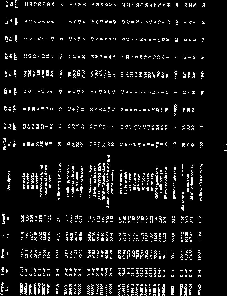
12
13 Lustdust High Grade Skarn Examples with 0.67 g/t gold and 0.80% copper over 59.4 meters from m. (Az 50 0 Dip -60 0, E, N) with 0.68 g/t gold and 0.92% copper over 37.5 meters from m. (Az 50 0 Dip -75 0, E, N) with 36.7 g/t gold, g/t silver and 2.89 % copper over 9.7 meters from to m. (Az 48 0 Dip-61 0, E, N) Incomplete holes ending in skarn grading 0.34% copper and 0.38 g/t gold at 174 meters at EOH. (Az Dip-50 0, E, N) Mineralized Porphyry (molybdenum) biotite diorite with Cu to 0.1% over narrow intervals and molybdenum to 633 ppm from 85 to 271m. (Az Dip-55 0, E, N) O1-34 monzonite porphyry, extremely anomalous molybdenum to 840 ppm from 14 to 273m. (Az 40 0 Dip-45 0, E, N) biotite diorite from 49m to EOH at 186 m. (Az 50 0 Dip-50 0, E, N) monzonite from 33 to 228 (then 7 m of hornfelse) and EOH at 235m. (Az 50 0 Dip-60 0, E, N) monzonite with molybdenum to 8320 ppm (0.83% Mo) from 232 to 286 m (Az 90 0 Dip-50 0, E, N) O1-40 monzonite from 44m to EOH at 243m. (Az 90 0 Dip-75 0, E, N) monzonite/diorite from 23m to EOH at 270m. (Az Dip-60 0, E, N) LD meters, diorite with repetitive reference to molybdenum as disseminations and in quartz veinlets, no samples collected. (Az 50 0 Dip-70 0, E, N)
14
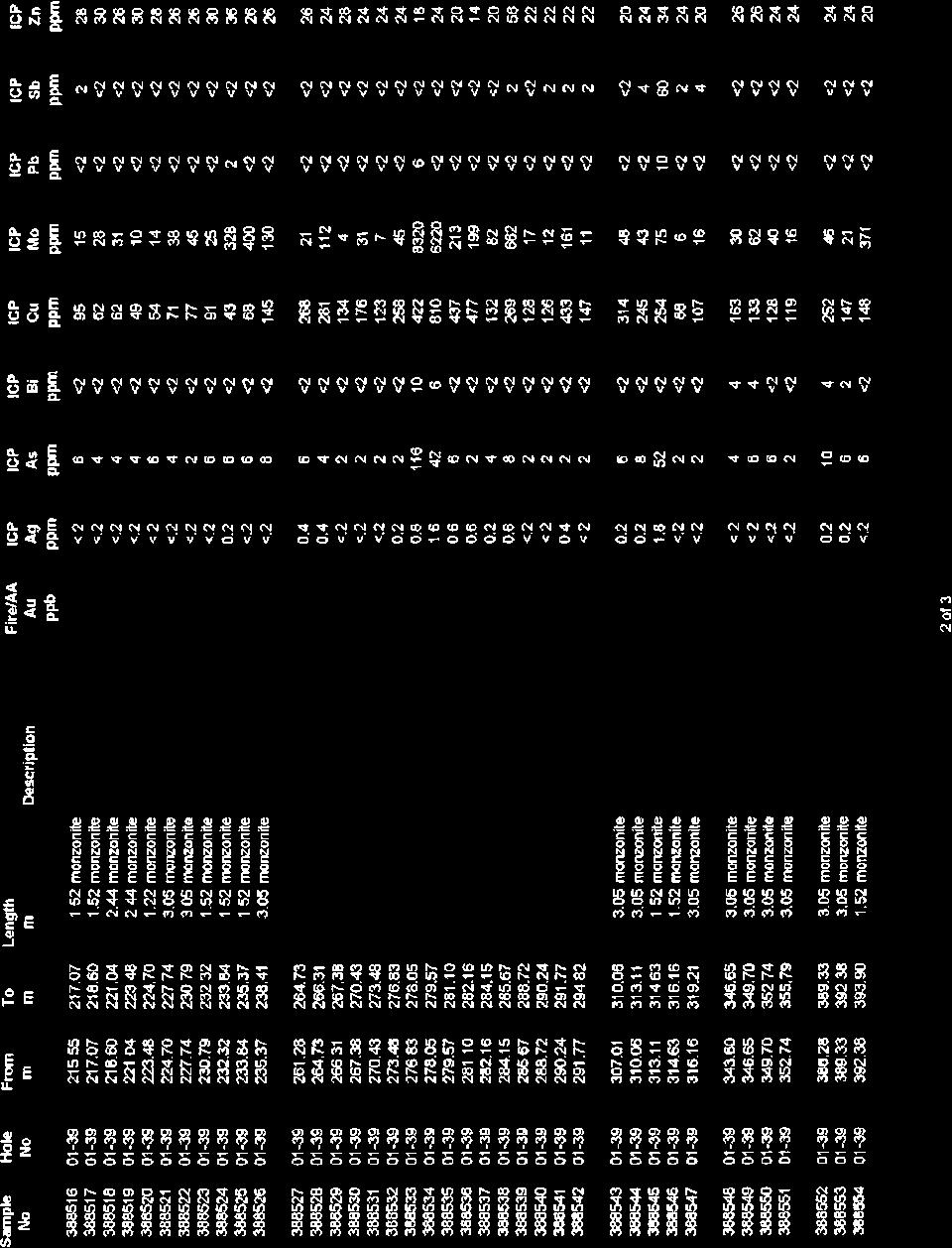
15
16
17
18 Lustdust Gold Intercepts (includes skarn with high gold) LD20-02 (AZ 270 Dip -45, E, N) 2.8 g/t Au, 59.5 g/t Ag and 3.9% Cu over 3.4 meters from 84.2 to 87.5 meters and 2.5 g/t Au, 329.1g/t Ag,3.4% Cu and 10.4% Zn over 3.4 meters from 95.4 to 98.8 meters Mineralization is in skarn LD20-5 (AZ 35 Dip -75, E, N) 3.1g/t Au, g/t Ag, 3.9% Cu and 3.5% Zn over 2.5 meters from 97.7 to meters Mineralization is in skarn LD20-6 (AZ 95 Dip -70, E, N) 4.2 g/t Au,151.7 g/t Ag, 5.1% Cu and 3.1% Zn over 2.7 meters from 99.9 to meters Mineralization is in skarn LD20-7 (AZ 95 Dip -85, E, N) 5.3 g/t Au, 98.5 g/t Ag and 2.9% Cu over 2.7 meters from to meters Mineralization is in skarn LD20-09 (Az 25 Dip -80, E, N) 8.7 g/t Au and 3.6 g/t Ag over 7.1meters from 64.1 to 71.2 meters and 2.1g/t Au,105.4 g/t Ag and 3.2% Cu over 2.9 meters from 85.5 to 84.4 meters and 9.6 g/t Au, and g/t Ag over 2.1 meters from 99.0 to meters Mineralization is in skarn and in vein with sulfasalts LD20-13 (AZ 65 Dip -75, E, N) 2.8 g/t Au, 34.3 g/t Ag and 2.2% Cu over 14.3 meters from 84.4 to 98.7 meters Mineralization is in skarn LD20-17 (AZ 45 Dip -75, E, N) 4.4 g/t Au, 41.5 g/t Ag and 2.5% Cu over 7.1meters from 90.5 to 97.6 meters Mineralization is in skarn
19 LD20-20 (AZ 25 Dip -70, E, N) 1.8 g/t Au, g/t Ag, 2.6% Cu and 17.0% zinc over 4.1meters from to meters Mineralization is in limestone. LD20-22 (AZ 55 Dip -60, E, N) 3.7 g/t Au, 65.1 g/t Ag and 2.1% Cu over 2.2 meters from to meters Mineralization is in skarn LD20-23 (AZ 55 Dip -70, E, N) 1.4g/t Au, 24.4 g/t Ag and 2.1% Cu over 13.9 meters from to meters Mineralization is in skarn LD20-24 (AZ 55 Dip -50, E, N) 3.9 g/t Au, 39.0 g/t Ag and 1.3% over 1.6 meters from to meters and 12.4 g/t Au and 17.0 g/t Ag over 0.3 meters from to meters Mineralization is in skarn LD20-26 (AZ 27 Dip -75, E, N) 5.1 g/t Au, 78.6 g/t Ag and 2.7% Cu over 2.2 meters from to meters Mineralization is in skarn DDH-2-02 (Az 50 Dip -57, E, N) 61.3 g/t Au and g/t Ag and 0.87% Cu over 1.0 meter from meters Massive sulfide at the contact of retrograde skarn and limestone. DDH (Az 50 Dip 50, E, N) 5.99 g/t gold over 2.0 meters from meters Structurally derived breccia discovered accidentally following shallowing of hole. DDH02-09 (Az 48 Dip-61, E, N) 36.7 g/t Au, g/t Ag and 2.89% Cu over 9.7 meters from to meters Near the contact of retrograde skarn and limestone (Az 270 Dip-68, E, N) g/t gold, g/t silver, 5.7% zinc and 1.1% lead over 5.0 meters from to 140.0m, massive sulfide in limestone at cherty argillite contact, near feldspar porphyritic dyke
20 03-11 (Az 274 Dip -68, E, N) 4.77 g/t gold, g/t silver and 0.8% zinc over 7.4 meters from to meters, Stringers of pyrite, arsenopyrite, stibnite and sphalerite hosted in cherty argillite (Az 65 Dip -66, E, N) 6.66 g/t gold, 12.6 g/t silver and 13.7% zinc over 3.7 meters from to m in oxidized massive sulfides, particularly pyrite, hosted in limestone (Az 65 Dip -45, E, N) 20.51g/t gold, 96.9 g/t silver, 2.5% zinc and 6.7% lead over 5.2 meters. Hosted in limestone (yellow-orange oxide) - Carlin Style? LD (Az 86 Dip -55, E, N) 50.7 g/t Au over 0.6 meters from to meters. Mineralization in prograde skarn associated with arsenopyrite, pyrrhotite and trace chalcopyrite. No sampling for the 58 meters above or the 10 meters below this intercept. LD04-08 (Az 76 Dip-55,346857E, N) g/t Au over 1.2 meters from to meters Weakly mineralized prograde skarn with patches of pyrrhotite and blebs of chalcopyrite. No sampling for 26 meters above and 46 meters below this intercept. LD04-13 (Az 87 Dip-70, N, N) g/t Au over 1.6 meters from meters. Prograde skarn with pyrrhotite as massive patches and blebs and blebs of chalcopyrite. No sample for 3 meters above. One sample over 2 meters below this intercept LD (Az 50 Dip -45, E, N) 22.6 g/t Au over 1.5 meters from to meters. (the 2005 report this as extending the CCS footwall high grade zone to 400 meters) LD05-17 (Az 50 Dip -60, E, N) 2.7 g/t Au, 85.1 g/t Ag and 2.13% cu over 8.5 meters from to meters This hole is 35 meters from LD (36.7 g/t Au, g/t Ag and 2.89% Cu over 9.7 meters In skarn style high-grade gold
21 LRCOG-23 (Reverse circulation hole) (Az 0 Dip-90, E, N) g/t gold over 7.6 metres from 68.6 to 76.2 metres including 46.9 g/t over 1.5 meters from 70.1 to 71.7 meters. Mineralization occurs in limestone with yellow/orange oxide. DDH (Az 96 o Dip 142 o, E, N 2.33 g/t gold over 7.8 meters from to meters and 5.36 g/t gold over 4 meters from to meters in skarn
22
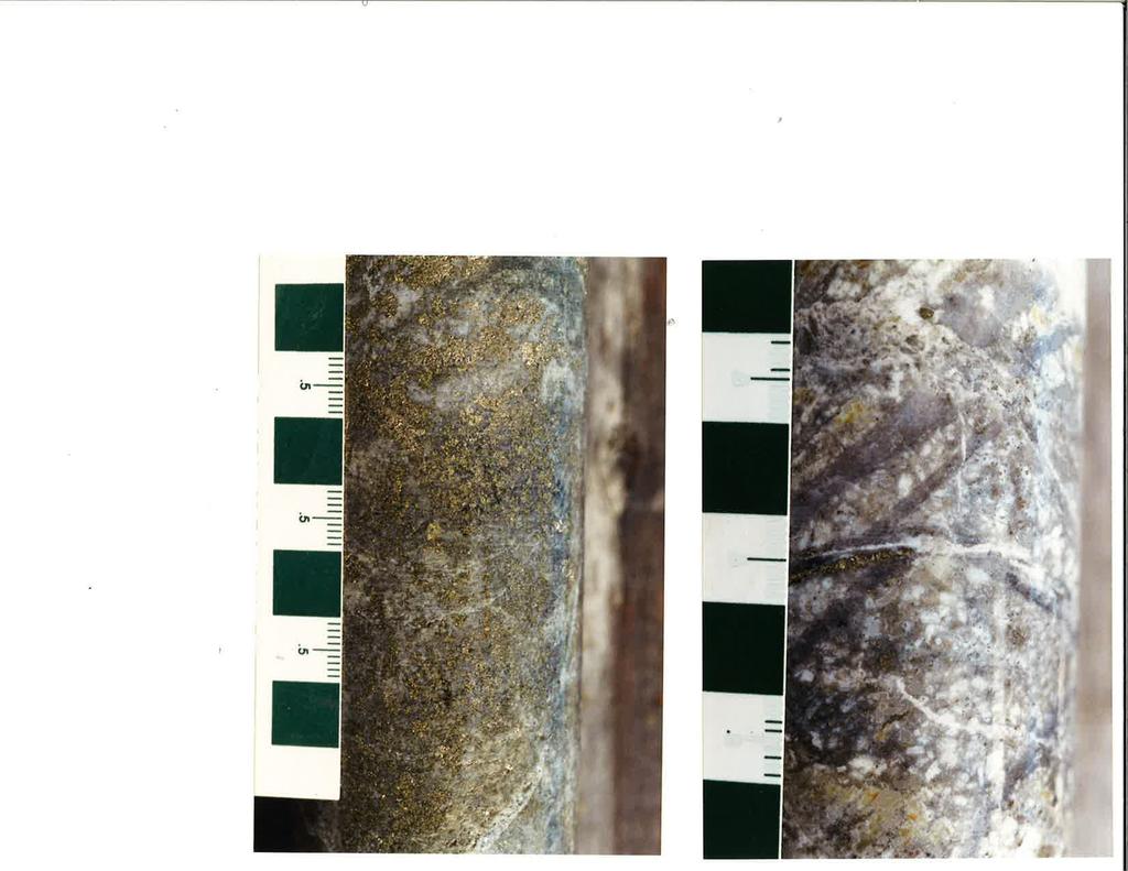
23 Lustdust Valley Zone In reverse circulation holes were drilled in the valley in the general area of the Bralorne Takla Mercury Mine. These vertical holes were spread over an area measuring 2,200 meters by 400 meters spaced on 100 meter centres on lines spaced 500 meters from each other. The most successful hole was hole LRC with an intercept of 6.1 meters grading g/t gold starting at a depth of 70.1 meters. This hole is located on the extreme southeast corner of the area tested. The individual assays that contributed to the g/t intercept were 0.214, 1.305, and g/t gold each over 1.5 meters. These samples were replicated three times and while the numbers jumped all over the place the composite results were comparable. As an example of this variability re-assays included an original assay of g/t gold which became 0.634, 1.83 and 2.62 g/t gold on each of the subsequent re-assays. Lithologies encountered in these holes are predominantly limestone, argillite and ash tuff (including lapilli tuff) with minor ultramafic rock, quartz veins and felsite dykes. Several zones of strong arsenic mineralization were identified (sometimes occurring with an orange yellow oxide) in limestone in holes closest to gold mineralization. LRC was twinned with diamond drill hole LD While LD did not directly replicate the numbers obtained in the reverse circulation hole it did encounter 16.8 meters grading g/t gold (from 89 meters)including values to 2.60g/t gold over 1.5 meters and a second intercept of g/t gold over 1.5 meters starting at meters. The hole intersected limestone with pyrite veining, an unidentified orange-yellow oxide, siderite and zones of breccia. A second diamond drill hole LD drilled 50 meters further to the west intersected 3 meters grading g/t gold (starting at 121 meters). This hole also intersected limestone with some sections displaying a strong orange-yellow oxide stain and arsenic values reaching 804 ppm. A third drill hole LD (probably actually RCH-06-22) was drilled 200 meters west of RCH This hole encountered argillite and ash tuff. The change in geology suggests a fault located between these holes. No reassays were completed for the diamond drill holes and rock quality determinations (RQD) were often very low (100% being totally intact core and 0% being completely broken). Much of hole LD had an RQD of only a few percent and the high grade interval of interest had an RQD averaging only 21%. The area to the south and east of the mineralized holes (LRC-06-23, LD and LD-06-32) remains untested. The nature of the mineralization in these holes, (limestone hosted, associated with arsenic mercury and antimony, proximity to a major fault (Pinchi) and proximity an Eocene intrusion has commonalties to Carlin Style mineralization. More drilling is warranted. The odd change in the sequence of drill holes from west to east, 21 followed by 22 followed by24 followed by23 may indicate a mistake in the data set in which the coordinates for RCH and RCH have been reversed. If this in fact what has occurred then the high grade intercept may have been obtained from the location of RCH and not twinned by a diamond drill hole completed at the location of RCH
24 Despite the fact that the area drilled surrounds the former producing Bralorne Takla Mercury Mine very little mercury was encountered in the drilling with the exception of hole LRC Other Reverse Circulation Drilling Highlights LRC and LRC with long intervals of anomalous zinc (to 1570 ppm) in argillite with local quartz and pyrite LRC-06-07, ash tuff seemingly with intercalated limestone. Copper is anomalous in ash tuff with individual samples reaching 4600 ppm copper tentatively identified as mineralized with native copper. (LRC was twinned by diamond drill hole LD which confirms the geology. Only 2 samples were analysed from the diamond drill hole.) LRC-06-08, Ash tuff and limestone with anomalous interval from feet ( m) 1,080 ppm arsenic and ppm gold LRC Limestone with local orange oxide and anomalous interval from 45 to 100 feet (13.7 to 30.4 m) averaging 1,182 ppm arsenic with values maximizing at 5,050 ppm As. LRC-06-24, Limestone with an anomalous interval from 45 to 100 feet (13.7 to 30.4 m) starting with anomalous arsenic to 1330 ppm and ending in anomalous mercury to 6330 ppm. The arsenic occurs higher in the hole and drops off as the mercury is encountered. Spotty gold to ppm occurs throughout the hole Recommendations Complete further sampling in hole LD (limestone, lapilli tuff, ash tuff and silicified argillite), only 2 samples so far submitted. Resample hole LD-06-31, particularly the interval which should twinning the high grade intercept in hole RCH (keeping in mind the nugget effect demonstrated by the repeat assays of the high grade intercept in reverse circulation hole RCH-06-23) Resample hole LD (again keeping in mind the nugget effect demonstrated by the repeat assays of the high grade intercept in reverse circulation hole RCH-06-23) Further reverse circulation drilling (to avoid the poor rock quality identified by the diamond drill coring). In this regard detail the area around RCH with four holes collared 10 meters north, 10 meters south, 10 meters east and 10 meters west of this hole to confirm the high grade intercept. (Note - despite the predominant attitude of faults in the vicinity of the Bralorne Takla Mine being The principal vein mined in 1943 had a strike of and a dip of 55 0 to the SW.) Source: 2006 Assessment Report

25 9/28/2011 APPENDIX C 1 GEOPHYSICAL MAPSF Tzx (In-line) In-Phase Profiles over 90Hz Rotated Tzx In-Phase Grid 1 Full size geophysical maps are also available in PDF format on the final DVD Report on Airborne Geophysical ZTEM and Magnetic Survey for Alpha Gold Corporation C
26 348,500 E 349,000 E 349,500 E # # # ,161,500 N ,161,500 N # # # # # 6,161,000 N # # # # # 6,161,000 N 6,160,500 N # # # # 6,160,500 N 1100 # # # 6,160,000 N 6,160,000 N # # # # # 348,500 E SCALE 1:10, ,000 E 349,500 E Kilometers Lust Dust Project Drilling 24 Apr 07
27
28
29 Kwanika Trend
30

31

32
33
34
35
The Cobalt Rainbow. Airborne geophysical maps show that a north trending aeromagnetic high suggests further undiscovered mineralisation.
 The Cobalt Rainbow The property is located on Greenstone Creek, approximately 4.8 kilometres south west of the creek mouth. The property is located about 24 km due west of Campbell River, in the east-central
The MAPLE BAY PROJECT Copper Silver - Gold
 The MAPLE BAY PROJECT Copper Silver - Gold Good grade and tonnage potential within close proximity to Tidewater The Maple Bay Copper Silver Gold Project covers highly favourable geological host rocks of
12 tons of high-grade ore was mined from the No. 1 vein with an average grade of 13 g/t gold, 3,250 g/t silver and 23.3% lead.
 DUNWELL MINE GROUP The Dunwell Mine Group (Dunwell, Dunwell East, Bear River/MM and Silvershot properties), which includes the historic, past-producing Dunwell mine, is located 8 km northeast of Stewart
COPPERSTONE RESOURCES AB INTERCEPTS ZONE OF CHALCOPYRITE-ARSENOPYRITE- BORNITE MINERALIZATION AT SVARTLIDEN IN FIRST DEEP DRILLHOLE FROM 720m-810m
 COPPERSTONE RESOURCES AB INTERCEPTS ZONE OF CHALCOPYRITE-ARSENOPYRITE- BORNITE MINERALIZATION AT SVARTLIDEN IN FIRST DEEP DRILLHOLE FROM 720m-810m In mid-january 2017 Copperstone Resource published a geological
Lands Parcels in IOL CO-20
 Lands Parcels in IOL CO-20 1 CO-20 The Izok Corridor Lupin - multi-million ounce past gold production (3.6 million oz of gold at average grade of 9.3 g/t Au) Approximately 1 million ounces of undeveloped
Drill locations for the 2015 program are highlighted in the geology map below.
 2015 Exploration Program The exploration program plan at KSM for 2015 was designed to improve the understanding of block cave targets and support engineering/environmental aspects of development scenarios.
Elephant Mountain, Alaska Intrusive Related Gold Project July Option to Earn 100%
 Elephant Mountain, Alaska Intrusive Related Gold Project July 2018 Option to Earn 100% CORPORATE Corporate DISCLOSURE Disclosure The information contained herein, while obtained from sources which we believe
GEOLOGY AND LITHOGEOCHEMISTRY OF THE CHILKO-TASEKO LAKES AREA* BY G.
 B Ministry of Energy, Mines and Petroleum Resources GEOLOGICAL BRANCH MINERAL RESOURCES DIVISION NOTES TO ACCOMPANY OPEN FILE - GEOLOGY AND LITHOGEOCHEMISTRY OF THE CHILKO-TASEKO LAKES AREA* BY G. P. McLAREN
HOWE COPPER MINE PROJECT HIGH GRADE Cu-Ag with Au
 HOWE COPPER MINE PROJECT HIGH GRADE Cu-Ag with Au The Howe Copper Mine property is located approximately 55 kilometres northwest of Vancouver, BC. It is situated at 1431 metres elevation on the eastern
ASX / MEDIA RELEASE 6 MAY MILE SILVER-LEAD-ZINC DISCOVERY; HIGH GRADE SILVER-GOLD IN ROCK CHIPS AT RUBY SILVER
 ASX / MEDIA RELEASE 6 MAY 2011 4-MILE SILVER-LEAD-ZINC DISCOVERY; HIGH GRADE SILVER-GOLD IN ROCK CHIPS AT RUBY SILVER Highlights: Silver-lead-zinc discovery at 4-Mile; mineralisation intersected in all
Silver Phoenix Resources Alaska Mineral Property Lichen--A Promising Copper Silver Gold Project Ready for Drill-Testing in 2017
 Silver Phoenix Resources Alaska Mineral Property Lichen--A Promising Copper Silver Gold Project Ready for Drill-Testing in 2017 Introduction, Prospect History, and Access Since 2005, Fairbanks, Alaska-based,
Rich Saddle North Au-Cu-Ag Porphyry Expands by 275m Along Strike and 250m Down-Dip
 GT Gold Drills 281 Metres of 0.65 g/t Au, 0.38% Cu, 1.38 g/t Ag (1.24 g/t AuEq 1 ) Within 685 Metres 2 of 0.40 g/t Au, 0.26% Cu, 1.03 g/t Ag (0.81 g/t AuEq) in Step-out Hole TTD098 Rich Saddle North Au-Cu-Ag
The Gold Hill s Big Chief Showing. Cross Section Line A-A' (Pighin 2014)
") GOLD HILL SUMMARY In 1864 gold fever struck in the south Kootenays east of Cranbrook, British Columbia as placer gold was discovered in the Wild Horse River. What followed was everything one can imagine
GOLD HILL SUMMARY In 1864 gold fever struck in the south Kootenays east of Cranbrook, British Columbia as placer gold was discovered in the Wild Horse River. What followed was everything one can imagine
CARIBOO - GRIZZLY ZINC PROJECT
 CARIBOO - GRIZZLY ZINC PROJECT The Grizzly Lake or Cariboo Zinc property straddles the gravel Weldwood 8400 logging road in the Grizzly Lake area about 55 kilometres northeast of Likely. Roads constructed
DISCOVERY OF MINERALISED PORPHYRY & MAGNETITE-COPPER-GOLD AT KAMARANGAN
 MEDUSA MINING LIMITED ABN: 60 099 377 849 Unit 7, 11 Preston Street Como WA 6152 PO Box 860 Canning Bridge WA 6153 Telephone: +618-9367 0601 Facsimile: +618-9367 0602 Email: admin@medusamining.com.au Internet:
Silver Phoenix Resources Alaska Mineral Property Lichen--A Promising Copper Silver Gold Project Ready for Drill-Testing in 2018
 Silver Phoenix Resources Alaska Mineral Property Lichen--A Promising Copper Silver Gold Project Ready for Drill-Testing in 2018 Introduction, Prospect History, and Access Since 2005, Fairbanks, Alaska-based,
ANTLER GOLD DRILLS GRAMS PER TONNE GOLD OVER 5.35 METRES AT THE WILDING LAKE GOLD PROJECT, NEWFOUNDLAND
 ANTLER GOLD DRILLS 10.01 GRAMS PER TONNE GOLD OVER 5.35 METRES AT THE WILDING LAKE GOLD PROJECT, NEWFOUNDLAND HALIFAX, NOVA SCOTIA (CNW December 13 th, 2017) Antler Gold Inc. ( Antler ) (TSX- V:ANTL) is
BCGold Corp. Discovery Driven
 BCGold Corp. Discovery Driven Sickle-Sofia Property Copper-Gold Porphyry Discovery in the Toodoggone Camp! Cautionary Statement This presentation does not constitute an offer to sell or solicitation of
Anthill Resources Yukon - An Update on the Einarson Project
 Anthill Resources Yukon - An Update on the Einarson Project The Eastern Extension of a Carlin-type Gold Trend in the Selwyn Basin Anthill Resources Ltd Yukon Claim Holdings Over 2400 km 2 Property Location
Summary of Rover Metals Geologic Mapping Program at the Up Town Gold Project, Northwest Territories
 October 13, 2017 Summary of Rover Metals Geologic Mapping Program at the Up Town Gold Project, Northwest Territories Vancouver, British Columbia, Canada - Rover Metals Corp., Rover, is pleased to provide
Amador Canyon Silver Mining Property Lander County, NV
 Amador Canyon Silver Mining Property Lander County, NV Over $1 million worth of exploration and evaluation work performed Favorable drill results including a return of 286 g/ton silver over 12.2 meters
Serengeti Resources Inc GEOCHEMICAL REPORT ON THE SHADOW PROPERTY a.
 Serengeti Resources Inc. 2004 GEOCHEMICAL REPORT ON THE SHADOW PROPERTY a. Located in the Johanson Lake Area Omenica Mining Division NTS 94D/9 6 degrees and 32 minutes North Latitude 126 degrees and 2
RECENT RESULTS FROM THE COMPANY S EXPLORATION PROGRAMME AT PROSPERO (PAMPAMALI NORTH) PROSPERO HIGHLIGHTS
 PROSPERO HIGHLIGHTS") 7 October 2015 Hunter Resources plc ( Hunter or the Company ) (AIM: HUN) RECENT RESULTS FROM THE COMPANY S EXPLORATION PROGRAMME AT PROSPERO (PAMPAMALI NORTH) The Company is pleased to announce the results
7 October 2015 Hunter Resources plc ( Hunter or the Company ) (AIM: HUN) RECENT RESULTS FROM THE COMPANY S EXPLORATION PROGRAMME AT PROSPERO (PAMPAMALI NORTH) The Company is pleased to announce the results
ASX Announcement. 28 January Drill results indicate large Porphyry Copper Gold System at Peenam
 ASX Announcement 28 January 2010 Drill results indicate large Porphyry Copper Gold System at Peenam Highlights: 270 metres of visible copper (gold) mineralisation in first diamond core hole at Peenam Prospect
Copper Reef to Drill Massive Sulphide Targets in Flin Flon
 12 Mitchell Road Tel: (204) 687-3500 Flin Flon, MB, R8A 1N1 CZC.CSE Fax: (204) 687-4762 copperreef.com February 28, 2019. Copper Reef to Drill Massive Sulphide Targets in Flin Flon Copper Reef Mining Corporation
NEW COBAR-STYLE COPPER DISCOVERY IN NSW
 ASX / MEDIA RELEASE 2 AUGUST 2011 NEW COBAR-STYLE COPPER DISCOVERY IN NSW Broad zone of copper-polymetallic mineralisation intersected at 4-Mile prospect Highlights: Wide zone of copper-silver-gold-lead-zinc
NEWS RELEASE Ocean Park Ventures Identifies Large Multi-Structure Sulfide Mineralized System Trapper Gold Project, British Columbia
 Suite 302 750 West Pender St Vancouver, BC V6C 2T7 Tel: 604-681-0084 Fax: 604-681-0094 www.oceanparkventures.com TSX-V SYMBOL: OCP NEWS RELEASE Ocean Park Ventures Identifies Large Multi-Structure Sulfide
DSM SYNDICATE DISCOVERS POLYMETALLIC MINERALIZATION WITH TALUS GRAB SAMPLES CONTAINING UP TO PERCENT LEAD AND 18
 DSM SYNDICATE DISCOVERS POLYMETALLIC MINERALIZATION WITH TALUS GRAB SAMPLES CONTAINING UP TO 92.8 GRAMS PER TONNE GOLD, 13,643 GRAMS PER TONNE SILVER, 13.85 PERCENT LEAD AND 18.65 PERCENT COPPER FROM DIFFERENT
Queenston intersects Contact Zone on the Pandora Property and new gold zones in Kirkland Lake
 1 Queenston intersects Contact Zone on the Pandora Property and new gold zones in Kirkland Lake TORONTO, Ontario, March 7, 2003. Queenston Mining Inc. (QMI-TSX) reports diamond drill results on its 100%
Haoma Mining NL A.B.N
 Haoma Mining NL A.B.N 12 008 676 177 Registered Office & Head Office: 411 Collins Street, Melbourne, Vic., 3000, GPO Box 2282U, Melbourne, Vic., 3001. Telephone (03) 9629 6888, Facsimile (03) 9629 1250
Altan Nar. Gold & Base Metal Discovery (Tsenkher Nomin Property) October 12 th, 2011
 October 12 th, 2011") Altan Nar Gold & Base Metal Discovery (Tsenkher Nomin Property) October 12 th, 2011 1 FORWARD-LOOKING STATEMENTS Certain information regarding Erdene ("the Company") contained herein may constitute forward-looking
Altan Nar Gold & Base Metal Discovery (Tsenkher Nomin Property) October 12 th, 2011 1 FORWARD-LOOKING STATEMENTS Certain information regarding Erdene ("the Company") contained herein may constitute forward-looking
PROSPECTORS ASSISTANCE PROGRAM MINISTRY OF ENERGY AND MINES
 BRITISH COLUMBIA PROSPECTORS ASSISTANCE PROGRAM MINISTRY OF ENERGY AND MINES GEOLOGICAL SURVEY BRANCH PROGRAM YEAR: 1999/2000 REPORT #: PAP 99-l 6 NAME: KIM ANSCHETZ PROSPECTORS TlEPORT on the 99 LOUIS
JAN FEB MAR APR MAY JUN JUL AUG SEP OCT NOV DEC DRILL CORE WEEKLY VOLUME 7. Wayne Hewgill, P. Geo Research Analyst
 JAN FEB MAR APR MAY JUN JUL AUG SEP OCT NOV DEC DRILL CORE WEEKLY VOLUME 7 01 02 03 04 05 06 07 08 09 10 11 12 13 14 15 16 17 18 19 20 21 22 23 24 25 26 27 28 29 30 31 Drill Core Weekly highlights drilling
For personal use only
 ASX ANNOUNCEMENT 2nd February 2012 PROMISING DRILLING RESULTS FROM KUINI PROSPECT IN ACEH ASX: PSP SHARE INFORMATION Issued Shares: 346.54m Unlisted Options: 20.95m BOARD OF DIRECTORS Chairman & MD: M.
TERAS FLAGSHIP CAHUILLA PROJECT
 TERAS FLAGSHIP CAHUILLA PROJECT Cahuilla Company s Main Asset is located in mining friendly Imperial County, California. Mine Development Associates completed a NI 43-101 resource report; reporting an
OYUT ULAAN COPPER GOLD PROJECT RECONNAISSANCE DRILLING RESULTS
 ASX / MEDIA RELEASE Manager Company Announcements By Electronic Lodgement 7 pages Company Announcements Office 6 June 2013 Australian Securities Exchange 4th Floor, 20 Bridge Street SYDNEY NSW 2001 OYUT
ATON RETURNS 22.2 METRES OF 2.77 GRAMS PER TONNE GOLD EQUIVALENT FROM HAMAMA WEST; VISIBLE GOLD DISCOVERED AT BOHLOG
 FOR IMMEDIATE RELEASE: ATON RETURNS 22.2 METRES OF 2.77 GRAMS PER TONNE GOLD EQUIVALENT FROM HAMAMA WEST; VISIBLE GOLD DISCOVERED AT BOHLOG Vancouver, April XX, 2017: Aton Resources Inc. (AAN: TSX-V) (
Narrow High-Grade Gold and Long Low-Grade Porphyry Gold and Copper-Gold Intercepts at Bulago
 CONTACTS PHONE EMAIL PO Box 52 +61 (08) 9295 0388 info@frontierresources.com.au West Perth FAX WEBSITE WA 6872 Australia +61 (08) 9295 3480 www.frontierresources.com.au ASX Limited Company Announcements
News Release No GOLD AND COPPER MINERALIZATION DISCOVERED DURING PHASE 2 EXPLORATION AT THE MCBRIDE PROPERTY
 November 19, 2018 TSX Venture Exchange Listed Frankfurt Exchange Listed News Release No. 303-2018 GOLD AND COPPER MINERALIZATION DISCOVERED DURING PHASE 2 EXPLORATION AT THE MCBRIDE PROPERTY Vancouver,
Drake Resources Limited Quarterly Activity Report June 2007
 Drake Resources Limited Quarterly Activity Report June 2007 HIGHLIGHTS New projects and targets continue to be identified in the Zinifex-Drake base metal alliance in Sweden, Canada and Australia With the
A New Direction. Copper-Gold Deposit at Thor TSX.V:COL. August 11, May 2013
 A New Direction Copper-Gold Deposit at Thor August 11, 2016 May 2013 TSX.V:COL FORWARD LOOKING STATEMENTS This presentation includes certain forward-looking information or forward-looking statements for
twd$ yqsi+hca
 -t@~cl--t,i twd$ yqsi+hca C ASSESSMENT REPORT ON THE OR0 1-5 CLAIMS NEAR GOLDBRIDGE, B.C. Lillooet Mining Division N.T.S. 92 J / 15 W Long. 122 51.5 W. Lat. 50 47.5 N. Owned by Levon Resources Ltd. Optioned
For personal use only
 ANNOUNCEMENT TO THE AUSTRALIAN SECURITIES EXCHANGE: 28 NOVEMBER 2012 DRILLING UPDATE MABILO PROJECT The Directors of Sierra Mining Limited ( Sierra ) are pleased to announce further results from reconnaissance
SAN LUCAS PROJECT Technical Data
 SAN LUCAS PROJECT Technical Data 1 San Lucas Overview 3km long mineralized Main Shear zone with 2 parallel vein structures identified 79 historical RC holes, ranging from about 32m-259m and averaging 158m
TSX-V NNA
 New Nadina Explorations Limited 1215 Greenwood Street, Greenwood, BC V0H 1J0 Office: 250-445-2260 Ellen Clements: 250-444-1005 Feature Silver Queen Project 1 12S-05 Core from Vein intercept DDH 12S-05
82 Richmond Street East Toronto, ON M5C 1P1 T: E: W: eskaymining.com
 NEWS RELEASE FOR IMMEDIATE RELEASE: DECEMBER 7, 2018 Eskay Mining Corp. Reports on 2018 Exploration on the SIB Property, Northwest B.C. Drilling Intercepts Broad Zones of Gold Mineralization - Potential
Mexico Project Portfolio 2011
 1 Mexico Project Portfolio 2011 Forward Looking Statement This presentation includes certain statements that may be deemed "forward looking statements". All statements in this presentation, other than
Queensland Mining Corporation Limited
 Queensland Mining Corporation Limited ABN 61 109 962 469 ASX Release 29 th July 2011 Drilling Commenced at Duck Creek Copper-Gold Project, Cloncurry, North-west Queensland Highlights RC drilling has commenced
2. The latter two intersections occur outside the presently defined mineral resource.
 Avidian Drills 67 m of 4.93 g/t Au, includes 39.8 m of 7.54 g/t Au, at Golden Zone Property, Alaska & Discovers New Zone Northeast of the Breccia Pipe Deposit (Toronto, Ontario January 18, 2018) Avidian
Carrapateena Mineral Resources Explanatory Notes April OZ Minerals Limited. Carrapateena Mineral Resources Statement April
 OZ Minerals Limited Carrapateena Mineral Resources Statement April 14 2011 CARRAPATEENA MINERAL RESOURCE STATEMENT April 14, 2011 The Carrapateena Resource Statement relates to an upgrading to an Inferred
EXPLORATION LICENCE SURROUNDING THE HISTORIC FALUN COPPER MINE GRANTED
 ASX ANNOUNCEMENT 30 August 2007 EXPLORATION LICENCE SURROUNDING THE HISTORIC FALUN COPPER MINE GRANTED The Drake-Zinifex Alliance application for an exploration licence that covers the historic Falun copper
CSA Mine Observations Applied to the Development of Regional Exploration Models
 CSA Mine Observations Applied to the Development of Regional Exploration Models 1 Introduction Recent work completed by the geology team has resulted in an improved understanding of the CSA mine system
High Grade Silver and Zinc intersected at the Plata Project, Yukon
 NEWS RELEASE TSX: SPD January 19, 2012 NR 01-12 www.silverpredator.com High Grade Silver and Zinc intersected at the Plata Project, Yukon Vancouver, British Columbia, January 19 th, 2012: Silver Predator
COMMANDER RESOURCES LTD.
 COMMANDER RESOURCES LTD. October Dome Gold Skarn Mt Polley Core Facility February 2016 1 August 2016 CORPORATE DISCLOSURE Disclaimer The information contained herein, while obtained from sources which
NEW HAZELTON, OMINECA M.D.,
 PROSPECTING REPORT JUDI 1 TO 6 MINERAL CLAIMS NEW HAZELTON, OMINECA M.D., B.C. MAP 93M/4E, LAT. SS014'N, LONG. 127'33'W OWNED BY: A. L'ORSA ANTHONY L'ORSA Smithers, B.C. 21 February, 1981 TABLE OF CONTENTS
For personal use only
 ASX QUARTERLY REPORT GEOPACIFIC RESOURCES NL ACN 003 208 393 ASX Code: GPR info@geopacific.com.au www.geopacific.com.au AUSTRALIAN OFFICE Suite 6, 125 Melville Parade Como, WA 6152 SEPTEMBER 2012 QUARTERLY
SOUTHWEST & NORTHWEST EXPLORATION PROJECTS BINGHAM CANYON MINING DISTRICT
 SOUTHWEST & NORTHWEST EXPLORATION PROJECTS BINGHAM CANYON MINING DISTRICT SALT LAKE AND TOOELE COUNTIES, UTAH SUMMARY FRIDAY, MARCH 20, 2009 1 Tooele County Salt Lake County GOOGLE EARTH September, 2006
CERRO PRIETO PROJECT MINERAL CONCESSIONS LOCATION AND ACCESS
 Cerro Prieto CERRO PRIETO PROJECT MINERAL CONCESSIONS The Cerro Prieto Project is comprised of three mining exploitation concessions encompassing 2,723 hectares in northern Sonora, Mexico. Oroco holds
CHAMPION BEAR RESOURCES
 CHAMPION BEAR RESOURCES EXPLORING ADVANCED STAGE PRECIOUS METAL PROPERTIES IN ONTARIO Exploration Update January 2011 Forward Looking Statements This exploration update contains forward looking statements
Timberline Completes Technical Reports on the Elder Creek and Paiute Porphyry Copper-Gold Projects, Nevada
 FOR IMMEDIATE RELEASE Timberline Completes Technical Reports on the Elder Creek and Paiute Porphyry Copper-Gold Projects, Nevada Coeur d Alene, Idaho November 29, 2018 Timberline Resources Corporation
Tameapa Regional Geology
 Tameapa Project 1 Tameapa Regional Geology History San Francisco Mines of Mexico Ltd. (San Francisco), which completed an exploration program, including six drill holes (1,157 m) between 1956 and 1959.
RESULTS OF OPERATIONS Semi Annual Exploration Report BANLUNG EXPLORATION LICENSE, CAMBODIA FOR THE PERIOD 2015:06:30 TO 2015:12:31
 RESULTS OF OPERATIONS BANLUNG EXPLORATION LICENSE, CAMBODIA FOR THE PERIOD 2015:06:30 TO 2015:12:31 Introduction Work over the period has included the completion of a detailed induced polarization geophysical
American Creek Resources is a precious metals exploration company with an impressive portfolio of high-potential gold
 American Creek Resources is a precious metals exploration company with an impressive portfolio of high-potential gold and silver projects in British Columbia. These include properties in B.C.'s prolific
Focus Acquires Porphyry Copper-Molybdenum Project, Peru; Historical Drilling includes 0.57% Cu and 0.7% Cu
 Focus Acquires Porphyry Copper-Molybdenum Project, Peru; Historical Drilling includes 190m @ 0.57% Cu and 71.7m @ 0.7% Cu July 11, 2012; Vancouver, Canada: Focus Ventures Ltd. (TSX-V: FCV) is pleased to
Discovery of Thick Zone of Magnetite-Rich M Veins Strengthens Potential for Nearby Porphyry
 Thursday s Gossan Copper-Gold Porphyry Diamond Drilling Update Discovery of Thick Zone of Magnetite-Rich M Veins Strengthens Potential for Nearby Porphyry ~100m intercept of magnetite-rich M -veins and
Mountain Maid Gold System Displays Major Size Potential
 29 July 2008 The Manager, Companies Australian Securities Exchange Ltd Electronic Announcement System Dear Sir, AXIOM MINING LIMITED (ASX CODE: AVQ) ASX Announcement Mountain Maid Gold System Displays
MORE HIGH-GRADE GOLD INTERSECTIONS FROM CITADEL S SHAYBAN PROJECT, SAUDI ARABIA
 Citadel Resource Group Limited ASX Release 7th July 2009 MORE HIGH-GRADE GOLD INTERSECTIONS FROM CITADEL S SHAYBAN PROJECT, SAUDI ARABIA Highlights: LATEST RC IN-FILL AND EXTENSIONAL DRILLING CONTINUES
For personal use only
 ASX ANNOUNCEMENT 6th February 2012 HIGH GRADE AU-CU INTERSECTIONS FROM KUINI PROSPECT IN ACEH ASX: PSP SHARE INFORMATION Issued Shares: 346.54m Unlisted Options: 20.95m BOARD OF DIRECTORS Chairman & MD:
Sotkamo Silver Mo i Rana and Tampere areas. Erkki Kuronen Chief Geologist, M.Sc., MAusIMM Sotkamo Silver Oy
 Mo i Rana and Tampere areas Erkki Kuronen Chief Geologist, M.Sc., MAusIMM Oy Mo i Rana and Tampere areas Erkki Kuronen Chief Geologist, M.Sc., MAusIMM Oy 2.9.2018 Silver 2 Deposits and Projects develops
entire 1.5 meter drift width
 GOLD HILL SUMMARY In 1864 gold fever struck in the south Kootenays east of Cranbrook, British Columbia as placer gold was discovered in the Wild Horse River. What followed was everything one can imagine
The ALTPF: OTCQB 9AJ1: FWB Altiplano Provides 2017 Exploration Update For Its Maria Luisa and Farellon Projects, Chile
 November 9, 2017 APN: TSXV The ALTPF: OTCQB 9AJ1: FWB Altiplano Provides 2017 Exploration Update For Its Maria Luisa and Farellon Projects, Chile Edmonton, Alberta - November 9, 2017 - Altiplano Minerals
Quaternary clays alluvial sands of the Shepparton Formation overlie the basement rocks.
 NAGAMBIE GOLDFIELD Regional Geological Setting The Nagambie Project is located within the Melbourne Structural Zone of Victoria. The lithologies range in age from the Upper Silurian Broadford Formation
DRILLING EXPANDS SIGNIFICANT COPPER-GOLD PORPHYRY SYSTEM AT IVANHOE S KHARMAGTAI PROJECT IN MONGOLIA
 For immediate release November 26, 2002 DRILLING EXPANDS SIGNIFICANT COPPER-GOLD PORPHYRY SYSTEM AT IVANHOE S KHARMAGTAI PROJECT IN MONGOLIA ULAANBAATAR, MONGOLIA Ivanhoe Mines Chairman Robert Friedland
Great Atlantic Rock Samples Return up to 5.8 oz. / ton Gold Golden Promise Property in Central Newfoundland
 Great Atlantic Rock Samples Return up to 5.8 oz. / ton Gold Golden Promise Property in Central Newfoundland FOCUSED ON EXPLORING ATLANTIC CANADA (TSXV : GR) (FRA: PH01) VANCOUVER, British Columbia August
Axiom Nightflower Drilling Progress and IP Survey Results, North Queensland
 1 July 2008 The Manager, Companies Australian Securities Exchange Ltd Electronic Announcement System Dear Sir, AXIOM MINING LIMITED (ASX CODE: AVQ) ASX Announcement Axiom Nightflower Drilling Progress
%+ '$# $) %, %*$ " $ $ ' %' !()'-!" %( %"%! " *'+ - % %$! $)! " $)!" !$ ' "! )( ! $ '%& ')- % % "!#( (( ((# $) ' ) ((* & *# ' % %"*# ( !!
 %, %*$ $ $ ' %' !()'-! %( %%! *'+ - % %$! $)! $)! !$ ' ! )( ! $ '%& ')- % % !#( (( ((# $) ' ) ((* & *# ' % %*# ( !!") 001L/14/0218 First Year Assessment Report of Prospecting, Rock and Stream Sediment Sampling On Licence 18880M, NTS 1L/14 Burin Peninsula Newfoundland and Labrador Submitted by: Keith Kelloway Work year:
001L/14/0218 First Year Assessment Report of Prospecting, Rock and Stream Sediment Sampling On Licence 18880M, NTS 1L/14 Burin Peninsula Newfoundland and Labrador Submitted by: Keith Kelloway Work year:
LINGIG PORPHYRY COPPER DISCOVERY
 MEDUSA MINING LIMITED ABN: 60 099 377 849 Unit 7, 11 Preston Street Como WA 6152 PO Box 860 Canning Bridge WA 6153 Telephone: 618-9367 0601 Facsimile: 618-9367 0602 Email: admin@medusamining.com.au Internet:
it AUSIMM COBAR MINING SEMINAR
 Straits Resources Limited it AUSIMM COBAR MINING SEMINAR Brownfields Exploration at Girilambone: Understanding the Mineralised Systems August 2010 Phil Shields / Phil Jones LOCATION TRITTON OPERATIONS
For personal use only
 ACN 092 471 513 6 February 2012 ASX Release New drill assays up to 4% Cu confirm high grade copper continues at depth at Empire s Yuinmery project in WA 3m @ 4.0% Cu within 6m @ 3.0% Cu in drill hole YRC11-41D
Montgomery Bedrock Geology 21d-Gowganda Formation: conglomerate, sandstone, siltstone, argillite
 Work Report 2014 Trenching Montgomery Township G-3303 Claim #4259384,4245818 Sault Ste. Marie Mining Division Michael & Yvon Gagne Montgomery Copper Property 1 P a g e 2 P a g e Montgomery Bedrock Geology
Gold Mineralization Potential in a Wabigoon Subprovince Granite-Greenstone Terrane, International Falls Area, Minnesota
 Gold Mineralization Potential in a Wabigoon Subprovince Granite-Greenstone Terrane, International Falls Area, Minnesota Manitoba Ontario Mn The State of Minnesota is located in the north-central portion
For personal use only
 Orion Gold NL ASX Release Orion Gold NL is an Australian gold exploration company focused on delivering value to shareholders through the successful exploration of the Company s highly prospective tenement
For personal use only
 ASX ANNOUNCEMENT ASX: IVG Date: 30 April 2012 Number: 030_300412 MARCH 2012 QUARTERLY REPORT SUMMARY Market Cap A$2.23m ($0.062 p/s) Issued Capital 36,006,006 Assay data and mineral alteration studies
JV Project Portfolio Executive Summary: Bruce Smith
 JV Project Portfolio Executive Summary: Bruce Smith September 5, 2012 Disclaimer Forward-Looking Statements This presentation contains forward-looking statements, including but not limited to comments
IVANHOE DISCOVERS IMPORTANT NEW GOLD-COPPER PORPHYRY DISTRICT IN SOUTHERN MONGOLIA NEW PORPHYRY DISTRICT NOW NAMED BRONZE FOX
 November 29, 2004 IVANHOE DISCOVERS IMPORTANT NEW GOLD-COPPER PORPHYRY DISTRICT IN SOUTHERN MONGOLIA NEW PORPHYRY DISTRICT NOW NAMED BRONZE FOX ULAANBAATAR, MONGOLIA Ivanhoe Mines Chairman Robert Friedland
ENCOURAGING GOLD-BASE METALS AT MAY DAY, MOLY- GOLD AT ATTUNGA
 ASX / MEDIA RELEASE 5 JULY 2010 ENCOURAGING GOLD-BASE METALS AT MAY DAY, MOLY- GOLD AT ATTUNGA Peel Exploration is pleased to announce that recent drilling at the Company s Attunga and May Day projects
SUMBA EXPLORATION UPDATE
 ASX RELEASE Tuesday, 23 November 2010 SUMBA EXPLORATION UPDATE Hillgrove Resources Limited (ASX:HGO) today announces a planned airborne geophysical survey, Pelitalira prospect progress and final results
FIRST YEAR ASSESSMENT REPORT PROSPECTING LICENCE 16512M MARYSTOWN AREA, BURIN PENINSULA NTS 1M/3
 FIRST YEAR ASSESSMENT REPORT OF PROSPECTING ON LICENCE 16512M MARYSTOWN AREA, BURIN PENINSULA NTS 1M/3 BY NATHANIEL NOEL MSc. FOR E. MICHELE NOEL MINERAL LICENCES: 16512 M WORK CONDUCTED: MID-SEPTEMBER
For personal use only
 Global Geoscience NEWS RELEASE 28 February, 2013 ASX Code: GSC NEW DRILL TARGETS AT LONE MOUNTAIN PROJECT, NEVADA, USA Global Geoscience Ltd ABN 76 098 564 606 ASX Code: GSC Current share price: $0.05
The 2009 Pozo Seco Molybdenum/Gold Discovery
 Extended Abstract for KEGS Symposium: MAG Silver Corporation (MAG) Cinco de Mayo Project Submitted by Ken Robertson, P.Geo., Delta, B.C. The 2009 Pozo Seco Molybdenum/Gold Discovery MAG Silver Corporation
Uncovering The Riches of the Abitibi Greenstone Belt of Canada
 1 TSX.V: ALZ June 2016 Uncovering The Riches of the Abitibi Greenstone Belt of Canada The Haultain Gold Discovery The Abitibi Greenstone Belt & Gold 170+ million oz of gold produced to date from more than
Magnetic Field and VLF Surveys on the Shining Tree Property. Claims: , , , , , , , ,
 December 29, 2014 NTS: 041P11 Magnetic Field and VLF Surveys on the Shining Tree Property Claims: 1203361, 4251801, 4251803, 4251805, 4263067, 4263068, 4270940, 4270436, 4276740 Churchill and Asquith Townships
lat ' N Long ' W
 305 7 ec1;, REPORT ON THE JERY CLAIMS OF POLA RESOURCES LTD. NTS 93L/16 0 0 lat. 54 45' N Long. 126 22' W BABIXE LAKE AREA OMINECA MINING DIVISION, B.C. PAUL PLICKA CONSULTING GEOLOGIST DECEMBER 30, 1981
SIMUKU DRILLING TO OVER 1000 METRES DEMONSTRATES SIGNIFICANTLY INCREASED TONNAGE POTENTIAL OF THE INFERRED RESOURCE
 ADDRESS PHONE PO Box 6965 +61(07) 5592 1001 Gold Coast Mail Centre FAX Qld 9726 Australia +61 (07) 5592 1011 EMAIL ABN 54 126 490 855 info@coppermoly.com.au WEBSITE www.coppermoly.com.au ASX Announcement
REGULUS DISCOVERS NEW GOLD-RICH, HIGH-GRADE COPPER-GOLD ZONE AT RIO GRANDE
 REGULUS DISCOVERS NEW GOLD-RICH, HIGH-GRADE COPPER-GOLD ZONE AT RIO GRANDE 257.2 metres with 0.53% Cu, 1.20 g/t Au, and 1.59 g/t Ag (1.19% Cu Eq or 2.39 g/t Au Eq) including 54.5 metres with 1.34% Cu,
SECOND DRILL HOLE IHAD2 INTERSECTS MINERALIZED TAPLEY HILL FORMATION AND MINERALIZED BASEMENT IRON FORMATION
 Suite 304, 22 St Kilda Road St Kilda Vic 3182 Ph: +61 3 9692 7222; Fax: +61 3 9529 8057 For Immediate Release 14 th September 2007 SECOND DRILL HOLE IHAD2 INTERSECTS MINERALIZED TAPLEY HILL FORMATION AND
Mishi Lake Gold Property Mishibishu Lake Area, Wawa
 Mishi Lake Gold Property Mishibishu Lake Area, Wawa Location, Accessibility, Infrastructure and Local Resources The property is located 40 km west of Wawa, Ontario, in the Mishibishu Lake Area, Sault Ste.
NEWS RELEASE CANADIAN ZINC REPORTS REMAINING DRILL RESULTS AT LEMARCHANT DEPOSIT, SOUTH TALLY POND PROJECT, NEWFOUNDLAND
 NEWS RELEASE CZN-TSX CZICF-OTCQB FOR IMMEDIATE RELEASE March 5, 2018 CANADIAN ZINC REPORTS REMAINING DRILL RESULTS AT LEMARCHANT DEPOSIT, SOUTH TALLY POND PROJECT, NEWFOUNDLAND 2017 drill program successfully
SQUARE POST PROJECT CHARTERS TOWERS NORTH QUEENSLAND AUSTRALIA
 SQUARE POST PROJECT CHARTERS TOWERS NORTH QUEENSLAND AUSTRALIA Square Post - Summary PROJECT DETAILS - SQUARE POST The Square Post exploration permit (EPM 18510) contains two styles of mineralisation:
ASX/Media Announcement 14 July 2010
 ASX/Media Announcement 14 July 2010 HIGH-GRADE DRILL RESULTS FROM ANDY WELL EXTEND WILBER LODE Diamond drilling at Andy Well intersects visible gold in quartz lodes below MNRC006, extending the depth of