TIGER GOLD EXPLORATION CORPORATION. Prospecting Over the HARKER HERITAGE PROPERTY AREA 1. Clifford Township, Ontario
|
|
|
- Patience Tamsyn Townsend
- 5 years ago
- Views:
Transcription
 643-2345 Fax (705) 643-2191 www.cxsltd.")

1 PO Box 219, Government Road, Larder Lake, Ontario, P0K 1L0, Canada Phone (705) Fax (705) TIGER GOLD EXPLORATION CORPORATION Prospecting Over the HARKER HERITAGE PROPERTY AREA 1 Clifford Township, Ontario C Jason Ploeger, B.Sc, P.Geo January 29, 2016
2 TABLE OF CONTENTS 1. SURVEY DETAILS PROJECT NAME CLIENT LOCATION ACCESS SURVEY AREA REGIONAL GEOLOGY PREVIOUS WORK SURVEY WORK UNDERTAKEN SURVEY LOG PERSONNEL SURVEY SPECIFICATIONS OVERVIEW OF SURVEY RESULTS DAY-1 NOVEMBER 20, DAY-2 NOVEMBER 23, DAY-3 NOVEMBER 24, LIST OF APPENDICES APPENDIX A: STATEMENT OF QUALIFICATIONS APPENDIX B: INSTRUMENT SPECIFICATIONS APPENDIX C: LIST OF MAPS (IN MAP POCKET) LIST OF TABLES AND FIGURES Figure 1: Location of the... 3 Figure 2: Sample Figure 3: Sample Figure 4: Sample Figure 5: Sample Figure 6: Sample Figure 7: Sample Figure 8: Sample Figure 9: Sample Figure 10: Sample Figure 11: Sample Figure 12: Sample CANADIAN EXPLORATION SERVICES LIMITED PLAN-EXECUTE-DISCOVER-DEVELOP Page ii
3 Figure 13: Sample Figure 14: Sample Table 1: Survey Log... 7 CANADIAN EXPLORATION SERVICES LIMITED PLAN-EXECUTE-DISCOVER-DEVELOP Page iii

4 1. SURVEY DETAILS 1.1 PROJECT NAME This project is known as the. 1.2 CLIENT TIGER GOLD EXPLORATION CORPORATION, 103 Government Road. Kirkland Lake, Ontario P2N 1A9 1.3 LOCATION The is located approximately 50 km northeast of Kirkland Lake, Ontario. The property consists of 375 mining claims comprising of over 850 units spanning Clifford, Elliot, Harker, Holloway, Tannahill and Marriott Townships within the Larder Lake Mining Division. Figure 1: Location of the CANADIAN EXPLORATION SERVICES LIMITED PLAN-EXECUTE-DISCOVER-DEVELOP Page 3
5 1.4 ACCESS Access to the property was attained with a 4x4 truck via highway 672 and highway 101. Numerous forestry access roads and trails were travelled by ATV to access the various parts of the property. is located within Clifford Township. Access to this area was directly off of highway 672 approximately 25.5 kilometers north of its intersection with highway 66. From here an ATV was used to access the survey region. 1.5 SURVEY AREA The traversed lines were established using a GPS in conjunction with the execution of the survey. The survey area was for reconnaissance and therefore randomly generated in the field based on topography and vegetation. 1.6 REGIONAL GEOLOGY The Rat Lake property is hosted in the Archean aged Blake River Group of the Abitibi subprovince. Volcanic rocks of the area are classified chemically as tholeiitic and calc-alkaline. They include a wide spectrum of rock types ranging from basalts to rhyolites. Intrusive rocks include gabbros, diorites and feldspar porphyries with scattered rare diabase dykes. Mapping in the region has identified a number of east west trending fold axis that lead to the repetition of units in a north south direction. 1.7 PREVIOUS WORK 1971 Kerr Addison Mines Limited Geophysics Magnetometer Geophysics VLF 1980 Falconbridge Nickel Mines Geophysics Magnetometer Geophysics VLF 1984 St. Joe Canada Inc. RC Drilling Geological 14 holes totaling 466.5m Mapping 1985 Lac Minerals Ltd. Diamond Drilling 1 hole totalling 508 feet 1986 Lac Minerals Ltd. Geophysics Magnetometer CANADIAN EXPLORATION SERVICES LIMITED PLAN-EXECUTE-DISCOVER-DEVELOP Page 4
6 1987 Ventex Energy Limited Diamond Drilling Geophysics Geophysics Geophysics 8 holes totalling 2973 feet Magnetometer VLF HLEM 1993 Merrick Geological Prospecting 1994 Alex Perron Geophysics Magnetometer Geophysics VLF 1994 JLF van den Berg 1996 Terry Link 1997 Terry Link 1998 Terry Link Diamond Drilling Geophysics Diamond Drilling Diamond Drilling Diamond Drilling Geophysics 1 hole totalling 3 feet Magnetometer 4 holes totaling 2465 feet 8 holes totaling 4765 feet 4 holes totaling 2632 feet Induced Polarization 1998 Porritt, Keast and Stoliker Geophysics Induced Polarization Geophysics VLF Geophysics Magnetometer Geochemistry MMI Geological Mapping Geological Prospecting 1999 Terry Link 2006 Brigadier Gold Limited Diamond Drilling Geophysics Diamond Drilling 5 holes totalling 2613 feet Induced Polarization 3 hole totalling 264 mters 2005 Geophysics Magnetometer CANADIAN EXPLORATION SERVICES LIMITED PLAN-EXECUTE-DISCOVER-DEVELOP Page 5
7 Geophysics Geological VLF Mapping Geophysics Magnetometer Geophysics VLF Geological Mapping Geophysics Magnetometer Geophysics VLF Geophysics HLEM Geological Mapping Geophysics Magnetometer Geophysics VLF Geophysics HLEM Geophysics Magnetometer Geophysics VLF Geological Mapping Geophysics Magnetometer Geophysics VLF Manual Stripping CANADIAN EXPLORATION SERVICES LIMITED PLAN-EXECUTE-DISCOVER-DEVELOP Page 6
8 2. SURVEY WORK UNDERTAKEN 2.1 SURVEY LOG Date Description Total Traverse (km) November 20, November 23, November 24, Table 1: Survey Log 2.2 PERSONNEL Bruce Lavalley of Britt, Ontario and Jason Ploeger of Larder Lake, Ontario performed the prospecting traverse and collected GPS waypoint data. 2.3 SURVEY SPECIFICATIONS The main purpose of the prospecting was to investigate to areas of outcrop exposure for potential mineralization. Rock samples were collected from outcrops crossed during the traverses. These samples were taken for reference purposes. CANADIAN EXPLORATION SERVICES LIMITED PLAN-EXECUTE-DISCOVER-DEVELOP Page 7


9 3. OVERVIEW OF SURVEY RESULTS ALL SAMPLES WERE TAKEN FOR REFERENCE PURPOSES ONLY! ALL SAMPLES WERE PRESENTED TO TIGER GOLD EXPLORATION CORPORATION. 3.1 DAY-1 NOVEMBER 20, 2015 Sample NAD 83 - Zone 17N E N The vegetation is composed of spruce in this area. An outcrop of similar rock type is repeated at location E N. Figure 2: Sample CANADIAN EXPLORATION SERVICES LIMITED PLAN-EXECUTE-DISCOVER-DEVELOP Page 8


10 Sample NAD 83 - Zone 17N E N The vegetation is mixed at this location. Figure 3: Sample CANADIAN EXPLORATION SERVICES LIMITED PLAN-EXECUTE-DISCOVER-DEVELOP Page 9


11 Sample NAD 83 - Zone 17N E N The vegetation is mixed at this location. This outcrop is a pillowed flow with stripping and channel sampling appearing to have been performed in the past. Figure 4: Sample CANADIAN EXPLORATION SERVICES LIMITED PLAN-EXECUTE-DISCOVER-DEVELOP Page 10


12 Sample NAD 83 - Zone 17N E N The vegetation is mixed at this location. Figure 5: Sample CANADIAN EXPLORATION SERVICES LIMITED PLAN-EXECUTE-DISCOVER-DEVELOP Page 11


13 Sample NAD 83 - Zone 17N E N The vegetation is mixed at this location. Figure 6: Sample CANADIAN EXPLORATION SERVICES LIMITED PLAN-EXECUTE-DISCOVER-DEVELOP Page 12


14 Sample NAD 83 - Zone 17N E N The vegetation is jack pine at this location. Figure 7: Sample CANADIAN EXPLORATION SERVICES LIMITED PLAN-EXECUTE-DISCOVER-DEVELOP Page 13


15 Sample NAD 83 - Zone 17N E N The vegetation is jack pine at this location. Figure 8: Sample CANADIAN EXPLORATION SERVICES LIMITED PLAN-EXECUTE-DISCOVER-DEVELOP Page 14


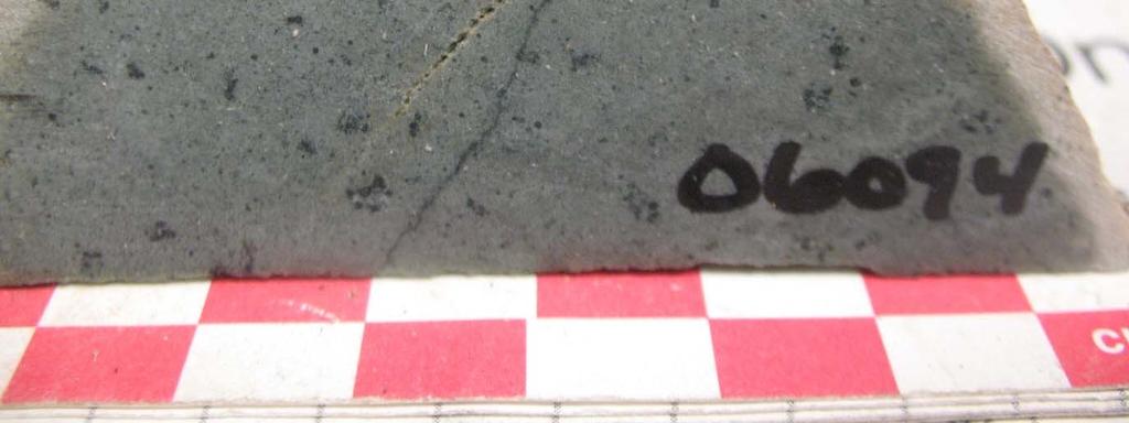
16 Sample 06093/06094 NAD 83 - Zone 17N E N These samples were collected from the same outcrop within a clearcut. The west side of the outcrop where sample was collected appeared to be a flow top breccia. The east side of the outcrop where sample was collected appeared to be a pillowed flow. Figure 9: Sample CANADIAN EXPLORATION SERVICES LIMITED PLAN-EXECUTE-DISCOVER-DEVELOP Page 15

17 Figure 10: Sample CANADIAN EXPLORATION SERVICES LIMITED PLAN-EXECUTE-DISCOVER-DEVELOP Page 16


18 Sample NAD 83 - Zone 17N E N The vegetation is a jack pine/spruce mix at this location. This outcrop appears to have been stripped and blasted in the past. Figure 11: Sample CANADIAN EXPLORATION SERVICES LIMITED PLAN-EXECUTE-DISCOVER-DEVELOP Page 17


19 3.2 DAY-2 NOVEMBER 23, 2015 Sample NAD 83 - Zone 17N E N This sample was collected from a large well mineralized boulder located in a jack pine stand. This boulder appears to not have travelled far and the source should be identified. Mineralization occurs along the cut edge and I would recommend assaying this sample. Figure 12: Sample CANADIAN EXPLORATION SERVICES LIMITED PLAN-EXECUTE-DISCOVER-DEVELOP Page 18
20 NAD 83 - Zone 17N E N At this location a diamond drill casing was located. CANADIAN EXPLORATION SERVICES LIMITED PLAN-EXECUTE-DISCOVER-DEVELOP Page 19


21 3.3 DAY-3 NOVEMBER 24, 2015 Sample NAD 83 - Zone 17N E N This outcrop is located within a jack pine stand. Figure 13: Sample CANADIAN EXPLORATION SERVICES LIMITED PLAN-EXECUTE-DISCOVER-DEVELOP Page 20


22 Sample NAD 83 - Zone 17N E N The vegetation is a balsam and birch mix and the topography is moderately sloping to the north-west. Figure 14: Sample CANADIAN EXPLORATION SERVICES LIMITED PLAN-EXECUTE-DISCOVER-DEVELOP Page 21

23 APPENDIX A STATEMENT OF QUALIFICATIONS I, C. Jason Ploeger, hereby declare that: 1. I am a professional geophysicist with residence in Larder Lake, Ontario and am presently employed as a Geophysicist and Geophysical Manager of Canadian Services Ltd. of Larder Lake, Ontario. 2. I am a Practicing Member of the Association of Professional Geoscientists, with membership number I graduated with a Bachelor of Science degree in geophysics from the University of Western Ontario, in London Ontario, in I have practiced my profession continuously since graduation in Africa, Bulgaria, Canada, Mexico and Mongolia. 5. I am a member of the Ontario Prospectors Association, a Director of the Northern Prospectors Association and a member of the Society of Geophysicists. 6. I do not have nor expect an interest in the properties and securities of Tiger Gold. 7. I am responsible for the final processing and validation of the survey results and the compilation of the presentation of this report. The statements made in this report represent my professional opinion based on my consideration of the information available to me at the time of writing this report. C. Jason Ploeger, P.Geo., B.Sc. Geophysical Manager Canadian Services Ltd. Larder Lake, ON January 29, 2016 CANADIAN EXPLORATION SERVICES LIMITED PLAN-EXECUTE-DISCOVER-DEVELOP
 WxHxD: Display size, WxH: Display resolution, WxH: Display type: Weight: Battery: Battery life: Waterproof: Floats: 1.43\" x 2.15\" (3.6 x 5.5 cm); 2.6\" diag (6.")
24 APPENDIX B GARMIN GPS MAP 62S Physical & Performance: Unit dimensions, 2.4" x 6.3" x 1.4" (6.1 x 16.0 x 3.6 cm) WxHxD: Display size, WxH: Display resolution, WxH: Display type: Weight: Battery: Battery life: Waterproof: Floats: 1.43" x 2.15" (3.6 x 5.5 cm); 2.6" diag (6.6 cm) 160 x 240 pixels transflective, 65-K color TFT 9.2 oz (260.1 g) with batteries 2 AA batteries (not included); NiMH or Lithium recommended 20 hours (IPX7) no CANADIAN EXPLORATION SERVICES LIMITED PLAN-EXECUTE-DISCOVER-DEVELOP
25 High-sensitivity receiver: Interface: Maps & Memory: Basemap: Preloaded maps: Ability to add maps: Built-in memory: Accepts data cards: high-speed USB and NMEA 0183 compatible no 1.7 GB microsd card (not included) Waypoints/favorites/locations: 2000 Routes: 200 Track log: Features & Benefits: Automatic routing (turn by turn routing on roads): Electronic compass: Touchscreen: Barometric altimeter: Camera: Geocaching-friendly: Custom maps compatible: Photo navigation (navigate to geotagged photos): Outdoor GPS games: 10,000 points, 200 saved tracks (with optional mapping for detailed roads) (tilt-compensated, 3-axis) no no (paperless) no CANADIAN EXPLORATION SERVICES LIMITED PLAN-EXECUTE-DISCOVER-DEVELOP
26 Hunt/fish calendar: Sun and moon information: Tide tables: Area calculation: Custom POIs (ability to add additional points of interest): Unit-to-unit transfer (shares data wirelessly with similar units): Picture viewer: Garmin Connect compatible (online community where you analyze, categorize and share data): Specifications obtained from CANADIAN EXPLORATION SERVICES LIMITED PLAN-EXECUTE-DISCOVER-DEVELOP
27 APPENDIX C LIST OF MAPS (IN MAP POCKET) Posted Traverse plan maps (1:20000) 1) TIGER-HARKER HERITAGE-AREA 1-PROSPECTING TOTAL MAPS = 1 CANADIAN EXPLORATION SERVICES LIMITED PLAN-EXECUTE-DISCOVER-DEVELOP
TIGER GOLD EXPLORATION CORPORATION. Prospecting Over the HARKER HERITAGE PROPERTY AREA 10. Harker Township, Ontario
 PO Box 219, 14579 Government Road, Larder Lake, Ontario, P0K 1L0, Canada Phone (705) 643-2345 Fax (705) 643-2191 www.cxsltd.com TIGER GOLD EXPLORATION CORPORATION Prospecting Over the HARKER HERITAGE PROPERTY
PROSPECTING Survey Over the AULD PROPERTY Auld Township, Ontario
 PO Box 219, 14579 Government Road, Larder Lake, Ontario, P0K 1L0, Canada Phone (705) 643-2345 Fax (705) 643-2191 www.cxsltd.com PROSPECTING Survey Over the AULD PROPERTY C Jason Ploeger, B.Sc, P.Geo August
SKEAD HOLDINGS LTD. Prospecting Over the. PUSEY LAKE PROPERTY Cardiff Township, Ontario
 PO Box 219, 14579 Government Road, Larder Lake, Ontario, P0K 1L0, Canada Phone (705) 643-2345 Fax (705) 643-2191 www.cxsltd.com SKEAD HOLDINGS LTD. Prospecting Over the PUSEY LAKE PROPERTY Cardiff Township,
TIGER GOLD EXPLORATION CORPORATION
 PO Box 219, 14579 Government Road, Larder Lake, Ontario, P0K 1L0, Canada Phone (705) 643-2345 Fax (705) 643-2191 www.cxsltd.com TIGER GOLD EXPLORATION CORPORATION Spectrometer Survey Over the HARKER HERITAGE
CJP EXPLORATION INC.
 CJP Exploration Inc. Larder Lake, Ontario P0K1L0 CJP EXPLORATION INC. Spectrometer Survey Over the TANNAHILL GOLD PROPERTY TABLE OF CONTENTS 1. SURVEY DETAILS... 3 1.1 PROJECT NAME... 3 1.2 CLIENT... 3
We are committed to providing accessible customer service. If you need accessible formats or communications supports, please contact us.
 We are committed to providing accessible customer service. If you need accessible formats or communications supports, please contact us. Nous tenons à améliorer l accessibilité des services à la clientèle.
Spectrometer Survey Over the Thompson Silver Property Donovan Township, Ontario
 PO Box 9, 579 Government Road, Larder Lake, Ontario, PK L, Canada Phone (75) 6-5 Fax (75) 6-9 www.cxsltd.com Spectrometer Survey Over the Donovan Township, Ontario C Jason Ploeger, B.Sc, P.Geo July, 5
KARIN BALZER Prospecting Survey Over the PACAUD CLAIM Pacaud Township, Ontario
 PO Box 219 14579 Government Road Larder Lake, Ontario P0K 1L0, Canada Phone (705) 643-1122 Fax (705) 643-2191 Prospecting Survey Over the PACAUD CLAIM 4200189 Pacaud Township, Ontario TABLE OF CONTENTS
CJP EXPLORATION INC.
 PO Box 219 14579 Government Road Larder Lake, Ontario P0K 1L0, Canada Phone (705) 643-1122 Fax (705) 643-2191 CJP EXPLORATION INC. Spectrometer Survey Over the SHEBA PROPERTY Nouvel Township, Ontario TABLE
Spectrometer Survey Over the Creelman-Roberts Property Roberts and Creelman Townships, Ontario
 PO Box 19 1479 Government Road Larder Lake, Ontario PK 1L, Canada Phone (7) 4-11 Fax (7) 4-191 Spectrometer Survey Over the Creelman-Roberts Property Roberts and Creelman Townships, Ontario Spectrometer
SEDEX MINING CORPORATION LTD.
 P.O. Box 219, 14579 Government Road, Larder Lake, Ontario, Canada, P0K 1L0 Telephone: +1 705.643.2345 Facsimile: +1 705.643.2191 Email: katrine@larder.ca www.explorationservices.ca SEDEX MINING CORPORATION
Magnetic Field and VLF Surveys on the Shining Tree Property. Claims: , , , , , , , ,
 December 29, 2014 NTS: 041P11 Magnetic Field and VLF Surveys on the Shining Tree Property Claims: 1203361, 4251801, 4251803, 4251805, 4263067, 4263068, 4270940, 4270436, 4276740 Churchill and Asquith Townships
Total Magnetic Field and VLF Surveys on the Swayze Property. Claim Swayze Township. Porcupine Mining Division
 1 January, 016 NTS: 041 O 15 Total Magnetic Field and VLF Surveys on the Swayze Property Claim 475471 Swayze Township Porcupine Mining Division 380850E, 599450N UTM Z17N NAD83 Report Prepared for: 540
PIOTR LUTYNSKI VANCOUVER, BRITISH COLUMBIA
 AN ASSESSMENT REPORT ON GROUND MAGNETIC SURVEYING CHUCHI PROPERTY FORT ST. JAMES AREA, BRITISH COLUMBIA OMINECA M.D. 55 17 N, 124 31 W NTS 93N/ 7&8 Claims Surveyed: 597976, 597878-597880 Survey Dates:
Report of Gridding and Magnetic Surveys. On the. Munro Property. Munro and Beatty Townships, Ontario. Larder Lake Mining Division
 Report of Gridding and Magnetic Surveys On the Munro Property Munro and Beatty Townships, Ontario Larder Lake Mining Division Claims: 39 4244 For Big Red Diamond Corporation October 3, 2 Timmins, Ontario
We are committed to providing accessible customer service. If you need accessible formats or communications supports, please contact us.
 We are committed to providing accessible customer service. If you need accessible formats or communications supports, please contact us. Nous tenons à améliorer l accessibilité des services à la clientèle.
for the Greenwood Mining Division, B.C. NTS 82E/7W 29' W, Longitude 118' 53' N Prepared by D. Dylan Watt, B.Sc.
 for the FltE NO: u VOLT 1, VOLT 2, VOLT 3, & VOLT 4 CLAIMS Greenwood Mining Division, B.C. NTS 82E/7W Latitude 49' 29' W, Longitude 118' 53' N Prepared by D. Dylan Watt, B.Sc. #309-1996 Trutch Street Vancouver,
for the Greenwood Mining Division, B.C. NTS 82E/7W Latitude 49' 27' W, Longitude 118' 5 Prepared by a= D. Dylan Watt, B.Sc.
 t. b LOGnO: 37~ -08 m. ACTIO#: for the AMP AMP 2 AMP 3 t AMP 4 CLAIMS Greenwood Mining Division, B.C. NTS 82E/7W Latitude 49' 27' W, Longitude 8' 5 %E c,w zc *& a w Prepared by a= -4c. D. Dylan Watt, B.Sc.
We are committed to providing accessible customer service. If you need accessible formats or communications supports, please contact us.
 We are committed to providing accessible customer service. If you need accessible formats or communications supports, please contact us. Nous tenons à améliorer l accessibilité des services à la clientèle.
1 CLAIMS GEOPHYSICAL REPORT ON BOYAL SITUATE NORTHEAST OF TILLICUM MOUNTAIN GOLD AREA BURTON - NAKUSP SIQCAEJ MINING DIVISION
 GEOPHYSICAL REPORT ON BOYAL 1 CLAIMS SITUATE NORTHEAST OF TILLICUM MOUNTAIN GOLD AREA BURTON - NAKUSP SIQCAEJ MINING DIVISION CONSULTING GEOLOGIST AUGUST 1983 VANCOUVER B *C INDEX INTRODUCTION ooa,.eoaaa.aaaoaaooaoa~ao~o
REPORT ON DIAMOND DRILLING SUBSTITUTION EAST PROPERTY CLAIMS AND HEBERT TOWNSHIP ONTARIO, CANADA
 REPORT ON DIAMOND DRILLING SUBSTITUTION EAST PROPERTY CLAIMS 1248920 AND 1248921 HEBERT TOWNSHIP ONTARIO, CANADA Adroit Resources Inc. Suite #610-1111 Melville Street Vancouver, British Columbia, Canada
SUMMARY REPORT. RE-ESTABLISH CLAIM BOUNDARY (Claim ) CARR TOWNSHIP (Larder Lake Mining Division) NTS (42 Al09) FOR
 CARR TOWNSHIP (Larder Lake Mining Division) NTS (42 Al09) FOR") 2.44330 " SUMMARY REPORT RE-ESTABLISH CLAIM BOUNDARY (Claim 3002288) CARR TOWNSHIP (Larder Lake Mining Division) NTS (42 Al09) FOR ST ANDREW GOLDFIELDS LTD. ""'1,.I Les 1. Kovacs, P. Geo For: St Andrew
2.44330 " SUMMARY REPORT RE-ESTABLISH CLAIM BOUNDARY (Claim 3002288) CARR TOWNSHIP (Larder Lake Mining Division) NTS (42 Al09) FOR ST ANDREW GOLDFIELDS LTD. ""'1,.I Les 1. Kovacs, P. Geo For: St Andrew
GEOLOGICAL MAPPING REPORT ON THE ASH MINERAL CLAIM OSOYOOS MINING DIVISION ASHNOLA RIVER MAP SHEET NTS M092,H019 MCBRIDE CREEK AREA, ASHNOLA RIVER,
 GEOLOGICAL MAPPING REPORT ON THE ASH MINERAL CLAIM OSOYOOS MINING DIVISION ASHNOLA RIVER MAP SHEET NTS M092,H019 LATITUDE 49 o O6, LONGITUDE 120 o 22 MCBRIDE CREEK AREA, ASHNOLA RIVER, KEREMEOS, B.C. CANADA
PHYSICAL WORK REPORT. the BAY CLAIMS. Omineca Mining Division Smithers, British Columbia N.T.S. 93E 13E/W
 PHYSICAL WORK REPORT the BAY CLAIMS Omineca Mining Division Smithers, British Columbia a N.T.S. 93E 13E/W LATITUDE: 53 57 00 N I LONGITUDE: 127 45 OO W for Home Ventures Ltd. 1201-675 West Hastings Street
%+ '$# $) %, %*$ " $ $ ' %' !()'-!" %( %"%! " *'+ - % %$! $)! " $)!" !$ ' "! )( ! $ '%& ')- % % "!#( (( ((# $) ' ) ((* & *# ' % %"*# ( !!
 %, %*$ $ $ ' %' !()'-! %( %%! *'+ - % %$! $)! $)! !$ ' ! )( ! $ '%& ')- % % !#( (( ((# $) ' ) ((* & *# ' % %*# ( !!") 001L/14/0218 First Year Assessment Report of Prospecting, Rock and Stream Sediment Sampling On Licence 18880M, NTS 1L/14 Burin Peninsula Newfoundland and Labrador Submitted by: Keith Kelloway Work year:
001L/14/0218 First Year Assessment Report of Prospecting, Rock and Stream Sediment Sampling On Licence 18880M, NTS 1L/14 Burin Peninsula Newfoundland and Labrador Submitted by: Keith Kelloway Work year:
RECONNAISSANCE AND SOIL GEOCHEMICAL SAMPLING REPORT PORCUPINE MINING DIVISION ON CLAIM , LANGMUIR TOWNSHIP
 RECONNAISSANCE AND SOIL GEOCHEMICAL SAMPLING REPORT ON CLAIM 1224499, LANGMUIR TOWNSHIP PORCUPINE MINING DIVISION CLM 1224499 NTS: 42A/06 Author: William Randall, P.Geo 1 Table of Contents Work Performed
RECONNAISSANCE GEOCHEMICAL SURVEY
 RECONNAISSANCE GEOCHEMICAL SURVEY LEGAL, RITA, LOUISE FR. (CHAPLEAU GROUP) REVERTED CROWN GRANTS CHAPLEAU CREEK AREAJ, SLOC& MINING DIVISION 82 F/11W Lat: 49'44" Long: 117"22'W MINERAL RESOURCES BRANCH
McGarry Project Vision & Plan
 McGarry Project Vision & Plan FORWARD LOOKING STATEMENTS We are in the mineral exploration and development business. It is inherently risky, and all potential investors should be keenly aware of this.
We are committed to providing accessible customer service. If you need accessible formats or communications supports, please contact us.
 We are committed to providing accessible customer service. If you need accessible formats or communications supports, please contact us. Nous tenons à améliorer l accessibilité des services à la clientèle.
DiaMine Exploration Inc. Pickle Lake Option Property
 DiaMine Exploration Inc. Pickle Lake Option Property Rock Sampling Program and Field Observations Claims 4249174, 4249175, 4249176 and 4249177, Kapkichi Lake Area (G-2081) And Claims 4249178, 4249179 and
We are committed to providing accessible customer service. If you need accessible formats or communications supports, please contact us.
 We are committed to providing accessible customer service. If you need accessible formats or communications supports, please contact us. Nous tenons à améliorer l accessibilité des services à la clientèle.
Interpretation Report on Borehole TDEM Surveys
 Interpretation Report on Borehole TDEM Surveys Junior Lake Property, Armstrong, Ontario For Landore Resources Canada Inc. Alan R. King, M.Sc., P.Geo. January 25, 2016 Introduction Alan King of Geoscience
ASSESSMENT REPORT MAGNETOMETER SURVEY GOLDEN ROD, GOLDEN ROD #2. Long.: General Delivery, Vananda, B. C.
 ASSESSMENT REPORT MAGNETOMETER SURVEY GOLDEN ROD, GOLDEN ROD #2 t=/ NTS 92~110w Lat.: Long.: 49O 44' N 124O 34' W Owner: E. Johanson General Delivery, Vananda, B. C. Operator: Rhyolite Resources I nc.
BALFOUR MINING LTD. (N.P.L.) HAM GROUP 92-P-6, CLINTON M. D.8 B. C. Lat 51 17'N, GEOCHEMICAL REPORT. V. CUKOR, P. Eng.
 HAM GROUP 92-P-6, CLINTON M. D.8 B. C. Lat 51 17'N, GEOCHEMICAL REPORT. V. CUKOR, P. Eng.") 34q '7 BALFOUR MINING LTD. (N.P.L.) HAM GROUP 92-P-6, CLINTON M. D.8 B. C. Lat 51 17'N, Long 12lo14'W GEOCHEMICAL REPORT, V. CUKOR, P. Eng. January 31, 1972 TABLE OF CONTENTS 1. INTRODUCTION 2. PROPERTY,
34q '7 BALFOUR MINING LTD. (N.P.L.) HAM GROUP 92-P-6, CLINTON M. D.8 B. C. Lat 51 17'N, Long 12lo14'W GEOCHEMICAL REPORT, V. CUKOR, P. Eng. January 31, 1972 TABLE OF CONTENTS 1. INTRODUCTION 2. PROPERTY,
Introducti on. Land Survey. Geomagnetic Survey. Geomagnetic Results and Interpretati ons - Conclusions and Recommendations C
 m M 42A86SW8281 63.42 PRICE 010 C O H T E H l 42A86SW828I 63.42 PRICE 010C Introducti on Land Survey Geomagnetic Survey Geomagnetic Results and Interpretati ons - Conclusions and Recommendations - - -
We are committed to providing accessible customer service. If you need accessible formats or communications supports, please contact us.
 We are committed to providing accessible customer service. If you need accessible formats or communications supports, please contact us. Nous tenons à améliorer l accessibilité des services à la clientèle.
ASSESSMENT REPORT TITLE PAGE AND SUMMARY
 ASSESSMENT REPORT TITLE PAGE AND SUMMARY TITLE OF REPORT: Assessment Report on Andys Bridge Mineral Claim, Turnagain River Area TOTAL COST: $2,100 AUTHOR(S): Bruce w Downing SIGNATURE(S): Bruce W Downing
GEOPHYSICAL REPORT THE CAVZ CLAIMS
 GEOPHYSICAL REPORT Magnetometer Survey on THE CAVZ CLAIMS CAVZ M.C.'s 1 to 12, 15 to 26, 29 to 40, 45 to 54 Trail Peak, Omineca M.D. 13 miles northeast of Fort Babine 550 ) 126 S.E. by G.Podolsky J.Russell
4. Geological maps published by the Ontario Department of Mines.
 52J08NWei45 S2J08NWa6B1 SMYE 010 AMALGAMATED RARE EARTH MINES LTD. *, SAVANT LAKE PROSPECT x ONTARIO INTRODUCTION t This Is a report on a group of 28 claims control led by Amalgamated Rare Earth Mines
RECEIVED DEC 2 9 MINING LANDS SECTION. By: John Kovala EM16R SURVEY REPORT OH GRID TA6 TANNAHILL TOWNSHIP. ONTARIO LARDER LAKE MINING DIVISION
 32D8SNEW33 Z, 1198* TANNAHILL 010 EM16R SURVEY REPORT OH GRID TA6 TANNAHILL TOWNSHIP. ONTARIO LARDER LAKE MINING DIVISION DISTRICT OF TIMISKAMING NTS 32D/5 LATITUDE: 48 PEG. 25 ' LONGITUDE: 79 PEG. 42'
Summary of Rover Metals Geologic Mapping Program at the Up Town Gold Project, Northwest Territories
 October 13, 2017 Summary of Rover Metals Geologic Mapping Program at the Up Town Gold Project, Northwest Territories Vancouver, British Columbia, Canada - Rover Metals Corp., Rover, is pleased to provide
Assessment Report on Diamond Drilling and. Application for Bulk Sampling. Mortimer Soapstone Project. Garnet Township NTS 41 OINE
 2. 9276 Assessment Report on Diamond Drilling and Application for Bulk Sampling Mortimer Soapstone Project Garnet Township NTS 41 OINE September 17, 2008 Todd Keast P.Geo. , INTRODUCTION In February 2007
PERCY CONTRACTING SERVICES LTD.
 GEOLOGICAL REPORT ON TEN PLACER LEASES (3139, 3140, 3141, 3142, 3143, 3144, 3145, 3146, 3147, 3148) MOREHEAD CREEK CARIB00 MINING DIVISION, B.C. 938/12W (52 38 N, 121 47 W) For PERCY CONTRACTING SERVICES
TECHNICAL REPORT ON THE BLACK CREEK PROPERTY FOR CARRIE ARRAN RESOURCES BLACK TOWNSHIP LARDER LAKE MINING DIVISION ONTARIO
 TECHNICAL REPORT ON THE BLACK CREEK PROPERTY FOR CARRIE ARRAN RESOURCES BLACK TOWNSHIP LARDER LAKE MINING DIVISION ONTARIO B.J. McKay, 8 February 2011 Keewatin, Ontario TECHNICAL REPORT BJML 2011 Table
PROSPECTING REPORT THE WALLACE CLAIM OMENICA MINING DIVISION. 54" x6" 3.d d. for. Reako Exlorat ions Ltd. Wallace Rev. C.G.
 PROSPECTING REPORT ON THE WALLACE CLAIM OMENICA MINING DIVISION 54"44 14 1x6" 3.d d by David A. Howard P.Eng. for Reako Exlorat ions Ltd. Claim Locat ion Wallace Rev. C.G. #1560 Dome Mountain Area 9 3
Prospecting Report 'S Office i DB Property, B.C. -J Negro Creek Nelson Mining District NTS 82F.050. Operator: Kootenay Gold Inc.
 . '.' I"' i9 12 Prospecting Report 'S Office i DB Property, B.C. -J Negro Creek Nelson Mining District NTS 82F.050 Operator: Kootenay Gold Inc. Owner: Darlene Lavoie Work Performed Summer of 2007 Report
We are committed to providing accessible customer service. If you need accessible formats or communications supports, please contact us.
 We are committed to providing accessible customer service. If you need accessible formats or communications supports, please contact us. Nous tenons à améliorer l accessibilité des services à la clientèle.
OWNER OPERATOR: BLACKWATER EXPLORATIONS LTD. REPORT ON SEISMIC REFRACTION SURVEY PLACER GOLD EXPLORATION
 OWNER OPERATOR: BLACKWATER EXPLORATIONS LTD. REPORT ON SEISMIC REFRACTION SURVEY PLACER GOLD EXPLORATION CARIBOO MINING DISTRICT NTS 93G CLAIM PC682023 Latitude 53 13 35.64 Longitude 122 49 40.65 by Russell
2014 AEROQUEST AIRBORNE HELI-BORNE VTEM PLUS AND HORIZONTAL MAGNETIC GRADIOMETER SURVEY ASSESSMENT REPORT CAMERON GOLD PROJECT
 2014 AEROQUEST AIRBORNE HELI-BORNE VTEM PLUS AND HORIZONTAL MAGNETIC GRADIOMETER SURVEY ASSESSMENT REPORT CAMERON GOLD PROJECT PREPARED BY: Nick Walker. January 2015 SUMMARY This report presents the results
1 FILMED 1. FILE NO:!..rsrru -* -. GRAND TWO CLAIM
 FILE NO:!..rsrru -* -. GRAND TWO CLAIM REPORT ON 1993 ASSESSMENT WORK GRAND TWO CLAIM REC. NO. 301849 NELSON MINING DIVISION NTS MAP SHEET 82F6/W 49 25'51" NORTH 117 18'08" WEST 1 FILMED 1 AUTHOR: R. Jordan,
Beekeeper Property The Geology South of Mint Lake. Cariboo Mining Division
 Beekeeper Property The Geology South of Mint Lake NTS: 93A/6 Cariboo Mining Division Claims: Beekeeper 1 #I2055 Beekeeper 2 #3892 Beekeeper 3 #7895 Beekeeper 4 #8503 Latitude: Longitude: 52 degrees 24
FIRST YEAR ASSESSMENT REPORT ON THE HAMMERDOWN SOUTH PROPERTY KING S POINT AREA, NEWFOUNDLAND
 FIRST YEAR ASSESSMENT REPORT ON THE HAMMERDOWN SOUTH PROPERTY KING S POINT AREA, NEWFOUNDLAND Licenses: 017558M, 017559M, 017560M and 017561M NTS Mapsheets: 012H/08 and 012H/09 Garry Fraser 66a Frontenac
Queenston intersects Contact Zone on the Pandora Property and new gold zones in Kirkland Lake
 1 Queenston intersects Contact Zone on the Pandora Property and new gold zones in Kirkland Lake TORONTO, Ontario, March 7, 2003. Queenston Mining Inc. (QMI-TSX) reports diamond drill results on its 100%
We are committed to providing accessible customer service. If you need accessible formats or communications supports, please contact us.
 We are committed to providing accessible customer service. If you need accessible formats or communications supports, please contact us. Nous tenons à améliorer l accessibilité des services à la clientèle.
Canadian Gold Miner Grab Sample Returns 29.5 Grams per tonne Gold from South Kirkland Project
 Canadian Gold Miner Grab Sample Returns 29.5 Grams per tonne Gold from South Kirkland Project Sudbury, July 27, 2017 Canadian Gold Miner Corp ( CGM, the Company) and Transition Metals Corp. (XTM TSX.V,
PHOENIX GEOPHYSICS LIMITED REPORT ON THE VLF-EM AND TOTAL FIELD MAGNETOMETER SURVEYS ON THE
 PHOENIX GEOPHYSICS LIMITED REPORT ON THE VLF-EM AND TOTAL FIELD MAGNETOMETER SURVEYS ON THE TAN CLAIMS, CHILLIWACK AREA NEW WESTMINSTER MINING DIVISION, BRITISH COLUMBIA FOR LORNEX MINING CORPORATION LIMITED
ASSESSMENT REPORT ON THE PEAVINE PROJECT. DGW & Associates # Alberni Street, Vancouver, British Columbia, V6E 4V2
 ASSESSMENT REPORT ON THE PEAVINE PROJECT KAMLOOPS MINING DIVISION BRITISH COLUMBIA NTS 082M 12 Latitude 51 36' 19.0"North -- Longitude --119 47' 27.0"West UTM Zone 11, NAD 83 5720827N 306744E Prepared
CARIBOO - GRIZZLY ZINC PROJECT
 CARIBOO - GRIZZLY ZINC PROJECT The Grizzly Lake or Cariboo Zinc property straddles the gravel Weldwood 8400 logging road in the Grizzly Lake area about 55 kilometres northeast of Likely. Roads constructed
A GUIDE TO WRITING AN ASSESSMENT REPORT ON YOUR CLAIMS
 A GUIDE TO WRITING AN ASSESSMENT REPORT ON YOUR CLAIMS PLEASE NOTE! In the following pages, suggestions and advice are in italics, under each heading. Use as a guideline only. Items in bold should be changed
ANTLER GOLD EXPLORATION UPDATE, WILDING LAKE GOLD PROJECT, NEWFOUNDLAND
 ANTLER GOLD EXPLORATION UPDATE, WILDING LAKE GOLD PROJECT, NEWFOUNDLAND HALIFAX, NOVA SCOTIA (CNW May 10, 2018) Antler Gold Inc. ( Antler ) (TSX-V:ANTL) is pleased to provide an update on its upcoming
Exploration on Claim , Lot 3, Con 5 and N ½ of N ½ Lot 3, Con 4, Sifton Tp, Kenora Mining District, Ontario.
 Exploration on Claim 3016830, Lot 3, Con 5 and N ½ of N ½ Lot 3, Con 4, Sifton Tp, Kenora Mining District, Ontario. For claimholder Colin Neilson, RR#1 Stratton ON P0W 1N0 NTS 52H/02 NW Bounded by UTM
2013 GEOLOGICAL ASSESSMENT REPORT SHERIDAN HILL PROPERTY
 2013 GEOLOGICAL ASSESSMENT REPORT ON THE SHERIDAN HILL PROPERTY NEW WESTMINSTER MINING DIVISION BRITISH COLUMBIA NTS 092G07 49 16 31 NORTH LATITUDE, 122 39 48 WEST LONGITUDE PREPARED FOR Sheridan Hill
National Instrument Technical Report
 National Instrument 43-101Technical Report Pigeon River Property Hartington Township Ontario, Canada Thunder Bay Mining Division, NTS 42A4 Geology Updated Technical Report UTM: Zone 16, 277134m E, 5332229m
WORK REPORT. on the ALEXO PROPERTY DUNDONALD TOWNSHIP PORCUPINE MINING DIVISION. for LIBERTY MINES INC.
 GEOSCIE CE AS r::;ss lent OFFICE WORK REPORT on the ALEXO PROPERTY DUNDONALD TOWNSHIP PORCUPINE MINING DIVISION for LIBERTY MINES INC. 2. 340 51 Submitted by: Steve Anderson VISION EXPLORATION 2041663
ASX ANNOUNCEMENT 4 March 2019 VTEM SURVEY COMMENCED OVER LORRAINE AND ADZ PROJECT AREAS
 ASX ANNOUNCEMENT 4 March 2019 VTEM SURVEY COMMENCED OVER LORRAINE AND ADZ PROJECT AREAS The Company is pleased to announce the commencement of a detailed airborne electromagnetic geophysical survey over
ASX announcement. Mylo-Frontier Pilbara Gold Project acquisition. 27 November Summary
 ASX announcement 27 November 2017 Andromeda Metals Limited ABN: 75 061 503 375 Mylo-Frontier Pilbara Gold Project acquisition Corporate details: Summary ASX Code: ADN Cash: $0.546 million (at 30 June 2017)
'-7' REPORT ON A MAGNETOMETER SURVEY OVER PART OF THE MAX CLAIM GROUP 1-20 LAC LE JEUNE AREA KAMLOOPS MINING DIVISION KAMLOOPS, BRITISH COLUMBIA
 I,., - SUITE 102. 222 BELLEVUE WES t ANCOUVER, B. '-7' REPORT ON A I MAGNETOMETER SURVEY OVER PART OF THE MAX CLAIM GROUP 1-20 LAC LE JEUNE AREA KAMLOOPS MINING DIVISION KAMLOOPS, BRITISH COLUMBIA 50-30
CONTENTS. Location, Access and History...6. Tenure Status and Geology Regional Andy Property Geology Map...9
 TYPE OFWORK IN THIS REPORT EXTENT OF WORK (rn METRTC UNITS) ON WHICH CLAIMS PROJECT COSTS APPORTIONED (incl. support) GEOLOGICAL (scale, area) Ground, mapping Photo interpretation GEOPHYSICAL (line-kilometres)
Compilation Report Hawke Hill South. Licence No M NTS 01N/06. Newfoundland and Labrador. Submitted by Gordon E. Cooper and Kevin P.
 Compilation Report 2010 Hawke Hill South Licence No. 017282M NTS 01N/06 Newfoundland and Labrador Submitted by Gordon E. Cooper and Kevin P. Ryan For Kevin P. Ryan (Licence holder) January, 2011 Work Year:
GOLDTRACK RESOURCES LTD, TECK TOWNSHIP, ONTARIO. NTS i\2 A/1
 42A01NEei33 63.5339 TECK 010 REPORT ON DIAMOND DRILLING GOLDTRACK RESOURCES LTD, PERRON LAKE AND WEDGE CLAIM GROUPS TECK TOWNSHIP, ONTARIO NTS i\2 A/1 MARCH 1989 D, R, HAWKE, B, Se,, M, Se,, F,G,A,C, 42AelNE*133
J.D. Mason, Prof. Engineer. Report on the Reconnaissance Magnetometer Survey. Completed for. North American Platinum Corporation Ltd.
 Report on the Reconnaissance Magnetometer Survey Completed for North American Platinum Corporation Ltd. Olivine Mountain Property, Tulameen, B.C. J.D. Mason, Prof. Engineer. November 28, 1967. Certificate
TOPOGRAPHICAL SURVEY REPORT ON THE GREENDROP PROPERTY NEAR CHILLIWACK, B.C. 92-H-3/W
 TOPOGRAPHICAL SURVEY REPORT ON THE GREENDROP PROPERTY NEW WESTMINSTER M.D. NEAR CHILLIWACK, B.C. 92-H-3/W Location: The central pap of the claims is located at coordinates 49 08'N, latitude by 121 26'W,
Copper Reef to Drill Massive Sulphide Targets in Flin Flon
 12 Mitchell Road Tel: (204) 687-3500 Flin Flon, MB, R8A 1N1 CZC.CSE Fax: (204) 687-4762 copperreef.com February 28, 2019. Copper Reef to Drill Massive Sulphide Targets in Flin Flon Copper Reef Mining Corporation
REPORT. on the. Omineca Mining Division, British Columbia. Latitude N., Longitude W. NTS map sheet 93F/7E. James W. McLeod, P.Geo.
 REPORT on the CHU MOLYBDENUM PROPERTY Omineca Mining Division, British Columbia Latitude 53 21 N., Longitude 124 37 W. NTS map sheet 93F/7E James W. McLeod, P.Geo. on behalf of Mr. Chris Delorme TABLE
July Exploring for Canadian Gold in the Rainy River District of Ontario
 July 2013 Exploring for Canadian Gold in the Rainy River District of Ontario 1 Forward Looking Statements Some of the statements in this document may be deemed to be "forward-looking statements". All statements
We are committed to providing accessible customer service. If you need accessible formats or communications supports, please contact us.
 We are committed to providing accessible customer service. If you need accessible formats or communications supports, please contact us. Nous tenons à améliorer l accessibilité des services à la clientèle.
Report on Prospecting on Claims & in the Federal Mine Property Teck Township Larder Lake Mining Division.
 1 Report on Prospecting on Claims 1227076 & 1222223 in the Federal Mine Property Teck Township Larder Lake Mining Division July 19, 2015 2 Table of Contents Introduction... 3 Summary... 3 Property Descriptions
GEOPHYSICAL REPORT ON THE PRINCE GEORGE PORPHYRY PROJECT LYNX PROPERTY
 GEOPHYSICAL REPORT ON THE PRINCE GEORGE PORPHYRY PROJECT LYNX PROPERTY Lynx Property Omenica Mining Division British Columbia Tenure # 841107, 742942, 741962 NTS Sheet 093K MTO Event Number - 5434711 UTM
FANCAMP EXPLORATION LTD.
 FANCAMP EXPLORATION LTD. Fancamp Exploration Ltd. Overview of Ontario Projects Prepared by: J. Kleinboeck, P.Geo. August 4 th, 2018 Dorothy Lake Project Comprised of 104 unpatented claims covering an
We are committed to providing accessible customer service. If you need accessible formats or communications supports, please contact us.
 We are committed to providing accessible customer service. If you need accessible formats or communications supports, please contact us. Nous tenons à améliorer l accessibilité des services à la clientèle.
FOCUSED ON ACQUIRING, EXPLORING AND ADVANCING QUALITY MINING PROJECTS IN THE AMERICAS CORPORATE PRESENTATION 1
 FOCUSED ON ACQUIRING, EXPLORING AND ADVANCING QUALITY MINING PROJECTS IN THE AMERICAS JUNE 2018 CORPORATE PRESENTATION 1 Disclaimer Except for the statements of historical fact contained herein, certain
We are committed to providing accessible customer service. If you need accessible formats or communications supports, please contact us.
 We are committed to providing accessible customer service. If you need accessible formats or communications supports, please contact us. Nous tenons à améliorer l accessibilité des services à la clientèle.
DIAMOND AND AIR CORE DRILLING TO COMMENCE ON WHITELAW GOLD BELT
 ASX ANNOUNCEMENT 17 OCTOBER 2017 DIAMOND AND AIR CORE DRILLING TO COMMENCE ON WHITELAW GOLD BELT Reconnaissance Air Core drilling to commence at Macorna Bore and Sebastian Projects Diamond drilling planned
Report. Mining Claim SO Butt Township. District of Nipissing. Southern Ontario Mining District. Richard Keevil ~ Geologist. August 29,2006.
 Report On Mining Claim SO 1077365 Butt Township District of Nipissing Southern Ontario Mining District ~ "'_I ""'..1 D I..:"'.U&O... ~u ~]. Richard Keevil ~ Geologist August 29,2006. Richard R. Keevil,
Advancing High Grade Gold Assets in Red Lake, Ontario
 Advancing High Grade Gold Assets in Red Lake, Ontario Forward Looking Statement Except for historical information contained herein, this presentation may contain forward-looking statements including but
PRECIOUS METALS. owner. JMT Services Corp. GEOCHPlICAL SAMPLING CHELASLIE WCE, NORTH CENTRAL, B.C. OMINECA MINING DIVISION NTS 93F/5E & 6W
 PRECIOUS METALS REPORT ON 1980 RECONNAISSANCE GEOCHPlICAL SAMPLING CHELASLIE WCE, NORTH CENTRAL, B.C. OMINECA MINING DIVISION NTS 93F/5E & 6W LATITUDE 53O28 N LONGITUDE 125O31 W DATES Qp WORK: JULY 10
compietea since tnat date, and wnicn comprisea btage I ot tne recommended
 compietea since tnat date, and wnicn comprisea btage I ot tne recommended four-stage program. GEOLOGY & MINERALIZATION The property situate6 on the southeast slope of Nickel Plate Mtn., and within the
GEOPHYSICAL REPORT CHU CHUA PROJECT Green Mountain Group. KAMLOOPS MINING DIVISION NTS 92P/8E, 82M/5W Lat: 51'24' N Long: 120'00' w
 I GEOPHYSICAL REPORT CHU CHUA PROJECT Green Mountain Group KAMLOOPS MINING DIVISION NTS 92P/8E, 82M/5W Lat: 51'24' N Long: 120'00' w I rvm #.,_..._..._._._.- $...-...! 1 VANCOUVER, B.C. 1 G E 0 I, 0.G
SIXTH SCHEDULE REPUBLIC OF SOUTH SUDAN MINISTRY OF PETROLEUM, MINING THE MINING (MINERAL TITLE) REGULATIONS 2015
 REGULATIONS 2015") SIXTH SCHEDULE REPUBLIC OF SOUTH SUDAN MINISTRY OF PETROLEUM, MINING THE MINING ACT, 2012 THE MINING (MINERAL TITLE) REGULATIONS 2015 Guidelines should be prepared by the Directorate of Mineral Development
SIXTH SCHEDULE REPUBLIC OF SOUTH SUDAN MINISTRY OF PETROLEUM, MINING THE MINING ACT, 2012 THE MINING (MINERAL TITLE) REGULATIONS 2015 Guidelines should be prepared by the Directorate of Mineral Development
IVANHOE DISCOVERS IMPORTANT NEW GOLD-COPPER PORPHYRY DISTRICT IN SOUTHERN MONGOLIA NEW PORPHYRY DISTRICT NOW NAMED BRONZE FOX
 November 29, 2004 IVANHOE DISCOVERS IMPORTANT NEW GOLD-COPPER PORPHYRY DISTRICT IN SOUTHERN MONGOLIA NEW PORPHYRY DISTRICT NOW NAMED BRONZE FOX ULAANBAATAR, MONGOLIA Ivanhoe Mines Chairman Robert Friedland
Montgomery Bedrock Geology 21d-Gowganda Formation: conglomerate, sandstone, siltstone, argillite
 Work Report 2014 Trenching Montgomery Township G-3303 Claim #4259384,4245818 Sault Ste. Marie Mining Division Michael & Yvon Gagne Montgomery Copper Property 1 P a g e 2 P a g e Montgomery Bedrock Geology
Jedway Enterprises Ltd st Ave, Surrey, BC V3S 3M3
 Jedway Enterprises Ltd. 104-19286 21 st Ave, Surrey, BC V3S 3M3 Prospecting Report on the Den (Den#1 to #4) Property, Takla Landing Area, Omineca Mining Division, British Columbia NTS 93N/12 Trim 093N052,093N062
BLURTON CREEK NICKEL PROPERTY. (Minfile # 082LNW-039)
") 5489153 BLURTON CREEK NICKEL PROPERTY (Minfile # 082LNW-039) Mara Lake Area / Salmon Arm B.C NTS - 82L-11 (UTM 83/Z10, 357690E, 5614220N) Prepared by: Jim Cuttle, B.Sc., P.Geo. 86 Cloudburst Road Whistler,
5489153 BLURTON CREEK NICKEL PROPERTY (Minfile # 082LNW-039) Mara Lake Area / Salmon Arm B.C NTS - 82L-11 (UTM 83/Z10, 357690E, 5614220N) Prepared by: Jim Cuttle, B.Sc., P.Geo. 86 Cloudburst Road Whistler,
VR SAMPLES 58.3 g/t GOLD AND 809 g/t SILVER AND STAKES NEW PROPERTY TO EXPAND ITS DANBO PROPERTY EPITHERMAL GOLD TREND IN NEVADA
 VR SAMPLES 58.3 g/t GOLD AND 809 g/t SILVER AND STAKES NEW PROPERTY TO EXPAND ITS DANBO PROPERTY EPITHERMAL GOLD TREND IN NEVADA NR-19-02 February 5, 2019, Vancouver, B.C.: VR Resources Ltd. (TSX.V: VRR,
GEOPHYSICAL ASSESSMENT REPORT ON THE CATALAN COPPER PROPERTY
 GEOPHYSICAL ASSESSMENT REPORT ON THE CATALAN COPPER PROPERTY McLeese Lake Area, B.C. NTS Map No. 93B/09 52"30'N Latitude 122"lO'W Longitude For: Operator, Stikine Gold Corporation 490-1 122 Mainland St.
West Pender Street Vancouver, BC V6C 2V6 Tel: Fax: TSX-V: GBR NEWS RELEASE
 1020 800 West Pender Street Vancouver, BC V6C 2V6 Tel: 604-646-8354 Fax: 604-646-4526 TSX-V: GBR NEWS RELEASE Great Bear Drills Hinge Zone Extensions - Results Include New 42 m Wide Zone with Multiple
PROSPECTING REPORT ON THE GARDEN LAKE AREA CLAIMS IN THE THUNDER BAY MINING DISTRICT FOR GRAVITY WEST MINING CORP NTS 52 H
 PROSPECTING REPORT ON THE GARDEN LAKE AREA CLAIMS IN THE THUNDER BAY MINING DISTRICT FOR GRAVITY WEST MINING CORP NTS 52 H Robert T. Chataway April 26, 2008 B.Sc. (Geology) Thunder Bay, Ontario. SUMMARY
True Width (m) Carneritos to
 Carneritos to") Exchange Tower 410-150 York Street Toronto, Ontario M5H 3S5 Canada www.mammothresources.ca FOR IMMEDIATE RELEASE: July 13, 2017 No. 08/17 Mammoth Resources Intersects 36.5 Grams per Tonne Gold in Channel
Exchange Tower 410-150 York Street Toronto, Ontario M5H 3S5 Canada www.mammothresources.ca FOR IMMEDIATE RELEASE: July 13, 2017 No. 08/17 Mammoth Resources Intersects 36.5 Grams per Tonne Gold in Channel
UNION MINIERE EXPLORATIONS AND MINING CORPORATION LIMITED ASSESSMENT REPORT ON FITINAT MINERAL CLAIM. Alberni Mining Division Record No.
 M F )( UNION MINIERE EXPLORATIONS AND MINING CORPORATION LIMITED Suite 200, 4299 Canada Way, Burnaby, B.C. V5G 1 H4 Telephone (604) 437-9491 ASSESSMENT REPORT ON GEOCHEMICAL SOIL SURVEYS AND ROCKSAMPLING