BOYKO - RAINBOTH - WALKER REPORT ON PROSPECTING GERALDTON - TASHOTA AREA THUNDER BAY MINING DIVISION JANUARY 25, 1991
|
|
|
- Dortha Wade
- 5 years ago
- Views:
Transcription
1 42L86NW182a SUMMIT LAKE BOYKO - RAINBOTH - WALKER REPORT ON PROSPECTING GERALDTON - TASHOTA AREA THUNDER BAY MINING DIVISION JANUARY 25, 1991
2 "ABLE OF CONTENTS SUMMIT LAKE 010C Introducti on Page l Project l Project 2 Project 3 Marshall Lake Toronto L., Castor L., Howard Falls Cavell L., Chara L., Ogoki Road Cavell Lake Maps l Location Map Prospecting Areas Marshall Lake Conductor l Conductor 2 Prospecting Magnetic Survey 7 VLF-EM Survey s MaxMin II Prospecting Project 2 Conductors 3A, 3B, 4 Prospecting Toronto Lake Prospecting (North) Prospecting (West) ^ Project 2 Castor Lake Cavell Lake Howard Falls Chara Lake Ogoki Road Cavell Lake Prospecting Prospecting Prospecting Prospecting Prospecting CI aim Map East Block West end Prospecting Prospecting ENCLOSURES Marshall Lake Conductor Location Plan
3 INTRODUCTION A partnership of W. P. Boyko, W. Rainboth and A.James Walker was formed to do -follow-up of the Ontario Geological Survey 1989 Airborne Electromagnetic, and Total Intensity Magnetic Survey, with the assistance of a grant from the Ontario Prospectors Assistance Program. In preparation for -field work, OGS assessment files were researched for areas of interest, shown tay the airborne survey. Overlays were made for the airborne maps, on which geology and previous work was transferred. In addition, airborne survey profiles were studied to confirm that conductors were from a bedrock source. Land positions were also added to the overlays. The program was divided into three projects, tt l Marshall Lake, #2 individual conductors at Toronto Lake, Castor Lake, Cavell Lake, Howard Fall s,ogoki Road and Chara Lake, and tt3 Cavell Lake, where claims were staked and ground geophysics carried out to explore a copper discovery. PROJECT l MARSHALL LAKE Five conductors were examined in the vicinity of Marshall Creek, south of Marshall Lake and are shown on enclosed location plan. Work was by Rainboth and Walker. (June 11-25,1990) Access to the conductors was possible via Marshall Creek, due to high water levels at the time of examination. Conductor l Conductor 2 A trail was cut into the area of the conductor from Marshall Creek and was located using VLF--EM. After some initial prospecting of nearby outcrops, 4 lines of recce mag and VLF--EM were run across the conductor. The surveys showed a good conductor with slightly higher magnetics. One picket line was cut to allow a test with MaxMin II EM.This showed the conductor located in low wet ground between outcrop areas,to have poor conductivity. Four claims were staked to cover the anomaly. A trail was cut into the conductor. The VLF-EM test showed the conductor to be in swamp, about 150m north of the outcrop area. No further work was warranted. The outcrop area was prospected. Conductors 3A and 3D The area of these 2 conductors was prospected and both conductors occur in low wet ground, as located with VLF--EM. Conductor 4 VLF-EM gave dips over 80"/. at the edge of the creek, showing conductor in creek. Prospected outcrops.
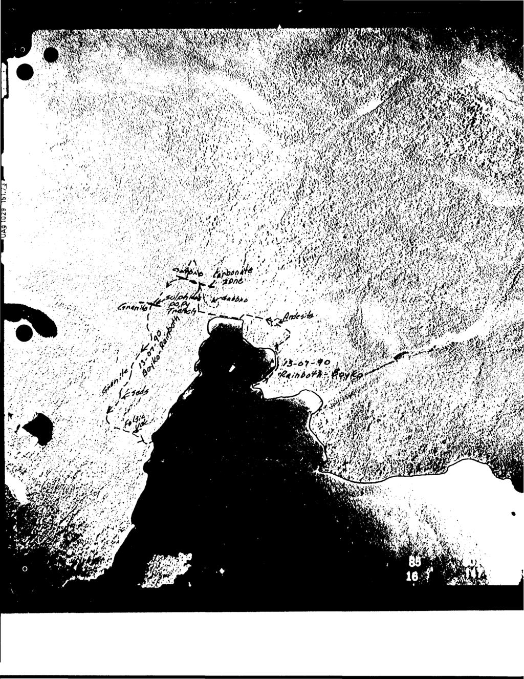
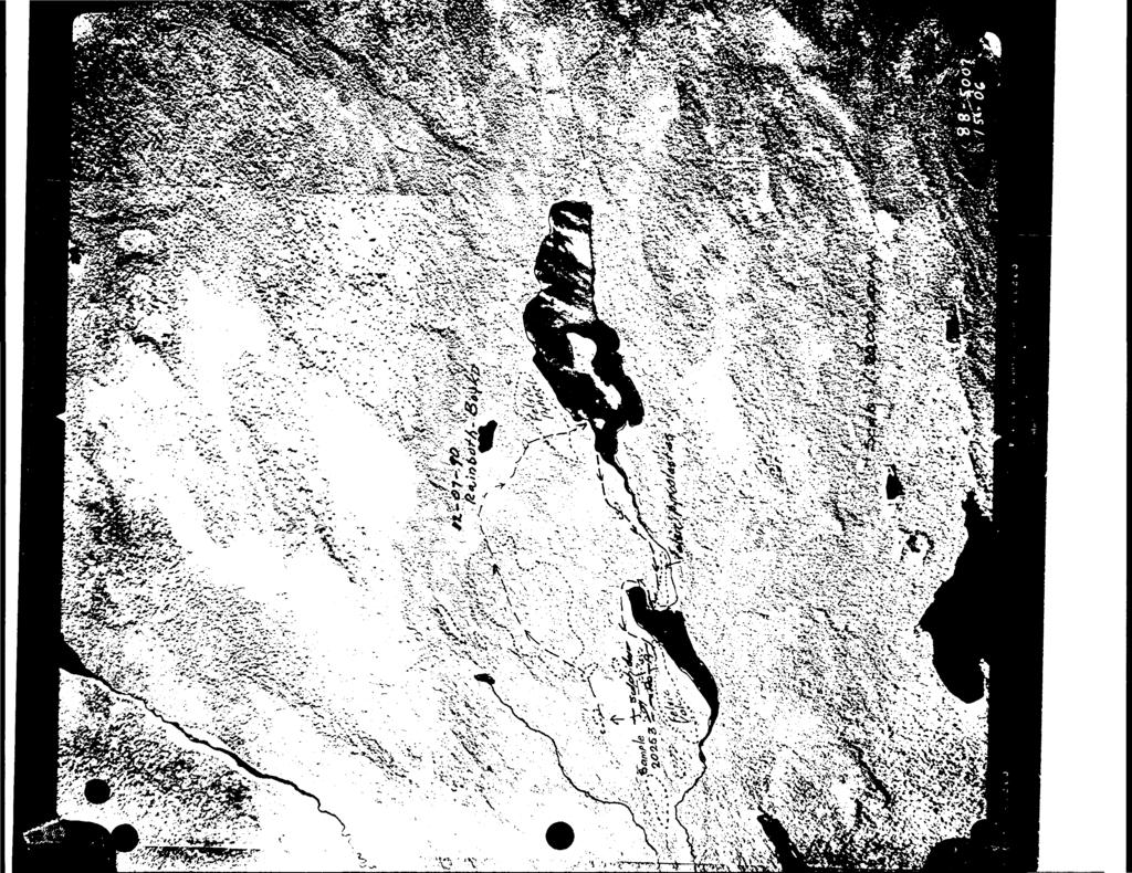
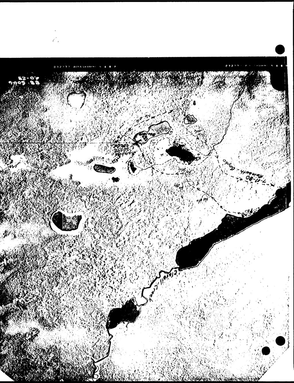
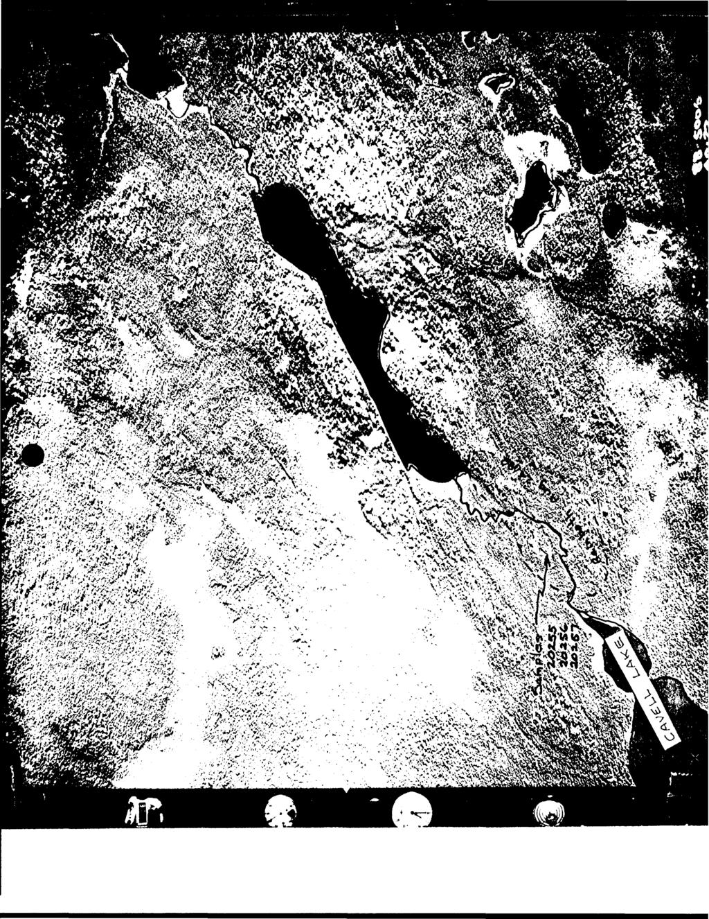
4 t PROJECT 2 TORONTO LAKE TORONTO L., CASTOR L., CAVELL L., HOWARD FALLS, CHARA L. OGOKI ROAD Rainboth and Boy k o flew into Toronto Lake -from Jell i coe. They traversed around the north end of the bay to check on conductors. They found an old trench with pyrite and pyrrhotite and a carbonate zone, as shown on sketch. (July 13) Rainboth drove to Toronto Lake and prospected west of main road. Located outcrops, no sulphides (July 9) CASTOR LAKE CAVELL LAKE HOWARD FALLS CHARA LAKE OGOKI ROAD Rainboth and Boyka flew into Castor Lake in Oboshkegan Township. Sulphide zone located. Sample assayed trace gold,. Ol"/. copper,.017. zinc. (July 12) Rainboth and Boyko flew into lake northeast of Cavell Lake. Located minor sulphides on lakeshore. Found copper bearing sulphide boulders near pond 1.5 km. southeast of lake. (July 11) Rainboth drove from Nakina. Examine conductor area. No outcrops seen in vicinity. ( Aug. 8) Rainboth drove from Nakina. Prospect near lake, east of road. Weak conductors. No outcrops found.(aug. 15) Rainboth drove from Nakina to conductor area as shown on sketch. No outcrops were seen in traverses.aug.12 PROJECT CAVELL LAKE After the discovery of copper mineralization, it was decided to cover the airborne conductors in the area with some 58 claims, plus an an additional 10 claims to the east, on a magnetic anomaly that appears to be a pipe like structure. Also, to do some stripping and blasting,prospecting as well as some ground geophysics. Mr. Glen Coyne and Mr. Pi erre Mail let of Timmins were engaged to carry out this work, and the partners also participated in these efforts. The airborne geophysical data over the area of interest was extracted and reprocessed in colour at a larger scale to facilitate interpretation and guide field work. An old trench with some sulphides was located in prospecting of conductors at west end of claims near creek between lakes.assays showed only trace in gold. During staking, linecutting and geophysics the only outcrops obsers'ed were at the west part of the group and along shore of lake on northwest of block. No outcrops were observed in prospecting the easterly claim block.
5 The discovery of mineralization was thought to be in outcrop. The stripping and blasting showed the mineralization to be in large boulders, less than 25 meters -from an airborne conductor. A grab sample assayed Cu. Another sample of the sulphides ran 0.20"/. C LI. The showing is located on the grid at 2+15E, 0+15N About 20km of l inecutting was done over 12 claims. Magnetic, VLF-EM and MaxMin II surveys were carried out. The ground surveys located the airborne results and had good correlation in most cases. The lake adjacent to the mineral location prevented complete coverage of the surveys. A separate report has been prepared for the ground surveys. Discussions were held with Teck Explorations November 13 and 22 to carry not further ground geophysics and diamond drill ing.we were advised verbally on January 23 that Teck is writing us to advise they are proposing to complete the geophysics prior to making a commitment for diamond drilling. Camping equipment, chain saw, generator, geophysical instruments, canoe and motor were supplied by E'oyko and Walker. All staking costs, including flying charges, camp supplies and labour has'e been charged to staking. Resp ec t f LI 11 y sub m i t ted W.P. Boyko W. Rainboth A. J&mss Walker
;-RUPERT DANFORD 7--^-.")
6 -I;*' ^:-..-;,:. ;;.i^x^t '^-/Tv, V-- :'^J -VV.-:, i'v-^*7^ - ^-^Al"----5;^':/-* T i ". -"^} ^);-RUPERT DANFORD 7--^-.- '*- ~-^"-- -±--- -"J.ic LOCATION MAP "n^ A
7 V17: : :7 t.r u T6 n T3 jct* ^ ^ LAKE AREA P SC-A.-E
8 O r \ 9 O o l 3H* o o it f Tt S o e O -o T o I r (H r* 9 o O C pi h. > W^'^m*^- ;r J'.-,';;^ '.trv ' :?' ; ;i ;:''^! ; ' : Si '
9 SVd 0V***.,,....,J ,,...-.-nw,;..;,.i -" -"-*" * T ~" -." -"-" "*"~ * "."*."*^
10 r H*. y Tit ' r.r. l }\...-'i fc l. - '.: v.:r---;!' ' ',': ; -":..:.1:^.li.- - ' -".;- :-^fsn :,^::ii:'.:r.::. -.- : :-:.:*:^-,:T.^^ -.i :.";r-'-----: --.!--\ -.H^h^ex.*, '^ ;;:l:r-l^;^- t;,p :r, : ^." ^.-.-*; T MARSHALL LAKE AREA.'.-Tr".". i 71 i -i * \ i t * ANOMALY \ It H ^ i^m TEST \oo\v \ t Jvve PROF\c-E SCALE 6PAC-/A/G- TO
11 * * M 8 1 r*
12
13

14 T?r-..j t.,.-/ t?- r S ^v - *----.*- :(-!'-?^W^3K - - A - - -/- -nn*~'ri\ ^^Tf \v.\xvs ;- ^ -^ V\ TT \^O i - v \\ f t l ^-_^- ; - *
15
16

17 . J -i \ -v V '. j,. * ' B 01^0 /i

18 OIZ
 ',X1~^CiJ-^ l l -' \ t v:^^f^\ftfcav\ 7yl^isk M:. J")
19 \,te4^ ' ':^^M*^^"I\ l^r "t:';r" sxsa. J^ ( ^^f^wijfej ; i /*n l,. ^M; 1ef^,,^^2^-~;:r3^^t^^S!s?{C'i:n^.* i -^" f"^- '".'/'M'06A.''^-^;~;\,'7f7( { ( C~\!) ',X1~^CiJ-^ l l -' \ t v:^^f^\ftfcav\ 7yl^isk M:. J
20 l ^o - \,1M447 -J HSeSIS.I1B85II i08, l IIS8O7 \ L it J X } M08320! JI5851S "M5'2 'j" 5"!'"!"'" 5, 0 ' j *,/ i.u...j-.-r ^ {--/.-i ^Q!". "-" In^oaS'T4 j VCO' i ID MI62I03 l t l JII62IC2 II62IOI j TB~ ~ f~tb ~ "'"ra" *~ H"TB~ l i l i i Il62098j II62C99 1I62IOO l ( L 4-_-J--^4----i ITB ITB. fa j 1) [li62096 'l!62095 i 1 I ' i L--J---J---J ^) X TOWNSHIP DANFORD M.N.R. ADMINISTRATIVE DISTRICT l GERALDTON MINING DIVISION THUNDER BAY

21 - -c. j i// 777 in hi- l f If,.9 '9 (, 'r LE^ i^ H \\? ; C < -t- ; r i: KT. i 7.K s i -: > \ 'i/ l l /x
22
23 63. se i e SUMMIT LAKE 900 III l S SUBMIT l AL CONSISTED OF VARIOUS REPORTS, SOME OF WHICH HAVE BEEN CULLED FROM THIS FILE. THE CULLED MAIERIAL HAD BEEN PREVIOUSLY SUBMIHLD UNDER THE FOLLOWING RECORD SERIES (HIE DOCUMENIS CAN BE VIEWED IN THESE SERIES): L/ik* Proper kj } Uoop On go l j] 1x^7.40
24 BoyKO, RAIN60TH, WALKER AfXl/^SH^LL L A/Tf PROJECT CO/VDUCrOR LOCATIONS SCALE l : ^ 42L06Nwiaae ea.ssie SUMMIT LAKE 200
SUPPLEMENT TO MAGNETOMETER 6 ELECTROMAGNETIC SURVEY REPORT. DATED NOVEMBER l, 1973 CIGLEN INVESTMENTS LIMITED CLAIMS GROUP BAD VERMILLION LAKE AREA
 ^ A R l ^ 1974 010 PROJECTS UNIT SUPPLEMENT TO MAGNETOMETER 6 ELECTROMAGNETIC SURVEY REPORT DATED NOVEMBER l, 1973 CIGLEN INVESTMENTS LIMITED CLAIMS GROUP BAD VERMILLION LAKE AREA DISTRICT OF RAINY RIVER
John A. Wakeford Noranda Exploration Co., Ltd, November 4, 1980 rinnnins, Ontario
 42CC1NEfc4e9 801101 ECHUM 010 " ' i-^y&sg?' '.. -.r. K;VW\\:.!^-*.]-^--'^-r-r^Pj^Q..-. ;,: v 1,;-'-,..- ^^-^^^^ysr-r^ijjfiv^jj. v -." ". '. ' "i - '' '. '':.;': s.'.ilv'., p...--'*l r-j@tw IP ^vt'.'v*:-^
We are committed to providing accessible customer service. If you need accessible formats or communications supports, please contact us.
 We are committed to providing accessible customer service. If you need accessible formats or communications supports, please contact us. Nous tenons à améliorer l accessibilité des services à la clientèle.
Toronto, Ontario November 16, This report may not be reproduced, in whole or in part, without the written permission of Derry, Michener S Booth.
 13 2.1354 L ITTLE 010 GEOPHYSICAL SURVEYS, LITTLE TOWNSHIP CLAIM GROUP OB-F TIMMINS AREA PORCUPINE MINING DIVISION, ONTARIO Toronto, Ontario November 16, 1973 This report may not be reproduced, in whole
Magnetic Field and VLF Surveys on the Shining Tree Property. Claims: , , , , , , , ,
 December 29, 2014 NTS: 041P11 Magnetic Field and VLF Surveys on the Shining Tree Property Claims: 1203361, 4251801, 4251803, 4251805, 4263067, 4263068, 4270940, 4270436, 4276740 Churchill and Asquith Townships
We are committed to providing accessible customer service. If you need accessible formats or communications supports, please contact us.
 We are committed to providing accessible customer service. If you need accessible formats or communications supports, please contact us. Nous tenons à améliorer l accessibilité des services à la clientèle.
Report. On a 3D Magnetic Inversion. For. Cadillac Ventures Ltd. And. Newcastle Minerals Ltd. Pickle Lake Project. Ontario, Canada
 Report On a 3D Magnetic Inversion For Cadillac Ventures Ltd And Newcastle Minerals Ltd. Pickle Lake Project Ontario, Canada SCOTT HOGG & ASSOCIATES LTD October 2010 TABLE OF CONTENTS 1 INTRODUCTION...
Report of Gridding and Magnetic Surveys. On the. Munro Property. Munro and Beatty Townships, Ontario. Larder Lake Mining Division
 Report of Gridding and Magnetic Surveys On the Munro Property Munro and Beatty Townships, Ontario Larder Lake Mining Division Claims: 39 4244 For Big Red Diamond Corporation October 3, 2 Timmins, Ontario
ZENMAC METAi, MINES LIMITED. SCHHKIBEK, ONTnHlO. PURVEY OK THE NI'COPOR PROPERTY
 63.2625 PAYS PLAT LAKE 010 ZENMAC METAi, MINES LIMITED SCHHKIBEK, ONTnHlO. PURVEY OK THE NI'COPOR PROPERTY IS'iRODUCTIQM The property, about 6 miles north of Schreiber, has been held by various people
RECONNAISSANCE AND SOIL GEOCHEMICAL SAMPLING REPORT PORCUPINE MINING DIVISION ON CLAIM , LANGMUIR TOWNSHIP
 RECONNAISSANCE AND SOIL GEOCHEMICAL SAMPLING REPORT ON CLAIM 1224499, LANGMUIR TOWNSHIP PORCUPINE MINING DIVISION CLM 1224499 NTS: 42A/06 Author: William Randall, P.Geo 1 Table of Contents Work Performed
Gold Mountain Group Gold Mtn. A, B, C & D Mineral Claims Record Nos. 697, 698, 699 & 700. Island Mountain Cariboo Mining Division British Columbia
 GOLD POINT RESOURCES LTD. Geophysical Survey Gold Mountain Group Gold Mtn. A, B, C & D Mineral Claims Record Nos. 697, 698, 699 & 700 Island Mountain Cariboo Mining Division British Columbia Vancouver,
Montgomery Bedrock Geology 21d-Gowganda Formation: conglomerate, sandstone, siltstone, argillite
 Work Report 2014 Trenching Montgomery Township G-3303 Claim #4259384,4245818 Sault Ste. Marie Mining Division Michael & Yvon Gagne Montgomery Copper Property 1 P a g e 2 P a g e Montgomery Bedrock Geology
In the past century, prospectors discovered
 FEATURE Instrumentation GDD Inc. s Beep Map Is prospecting dead? By Edwin Gaucher, Eng., Ph.D. and Pierre Gaucher, Eng., MBA In the past century, prospectors discovered many mines while examining shorelines
We are committed to providing accessible customer service. If you need accessible formats or communications supports, please contact us.
 We are committed to providing accessible customer service. If you need accessible formats or communications supports, please contact us. Nous tenons à améliorer l accessibilité des services à la clientèle.
42AeSSWW) KEEFER
 KEEFER") MINGOLD RESOURCES INC. 42AeSSWW)51 63.6098 KEEFER 010 REPORT ON A DIAMOND DRILLING PROGRAM CARRIED OUT ON SIMS AND CONTINENTAL PROPERTIES KEEFER TOWNSHIP PORCUPINE MINING DIVISION NTS 4 2A/5 By Dr* R*
MINGOLD RESOURCES INC. 42AeSSWW)51 63.6098 KEEFER 010 REPORT ON A DIAMOND DRILLING PROGRAM CARRIED OUT ON SIMS AND CONTINENTAL PROPERTIES KEEFER TOWNSHIP PORCUPINE MINING DIVISION NTS 4 2A/5 By Dr* R*
Norlex Mines Property. Whitefish Bay Area, Kenora District. The property of Norlex Mines under option to Canadian Javelin
 52E09SW0025 63.2231 WHITEFISH BAY AND MA Norlex Mines Property D: KENORA 010 D. SEP 14-1967 RECEIPT No. MINING DIVISION Whitefish Bay Area, Kenora District. '; Introduction The property of Norlex Mines
SELCO EXPLORATION COMPANY LIMITED
 --..-..-...-.....l.iibibiiiiiiiiiiiiiii II III S2J16NW9001 52J16NW0014A1 PASHKOKOGAM LAKE 0 10 SELCO EXPLORATION COMPANY LIMITED GEOPHYSICAL REPORT CLAIMS 200696 TO 200707 PATRICIA MINING DIVISION August
The MAPLE BAY PROJECT Copper Silver - Gold
 The MAPLE BAY PROJECT Copper Silver - Gold Good grade and tonnage potential within close proximity to Tidewater The Maple Bay Copper Silver Gold Project covers highly favourable geological host rocks of
December 6th I960. President and Directors, Chipman Lake Mines Ltd. 25 King Street West, Toronto.
 OFFICE: EM, 3-3933 RES.: HU. 1-1265 "' Mfc 42A85NE0127 63.1089 GODFREY 010. D. President and Directors, Chipman Lake Mines Ltd. 25 King Street West, Toronto. December 6th I960 REPORT ON GEOPHYSICAL SURVEY
GROUND GEOPHYSICAL SURVEYS Magnetometer and Horizontal Loop EM. KoKoKo Project Ferrim Lake and Tasse Lake Grids. PANTHEON VENTURES LTD.
 NTS 31 M/4 GROUND GEOPHYSCAL SURVEYS Magnetometer and Horizontal Loop EM KoKoKo Project Ferrim Lake and Tasse Lake Grids PANTHEON VENTURES LTD. September 2007,..-- :. 57 RECEVED JAN 16 ~'2:n GEOSCENCf
CHAMPION BEAR RESOURCES
 CHAMPION BEAR RESOURCES EXPLORING ADVANCED STAGE PRECIOUS METAL PROPERTIES IN ONTARIO Exploration Update January 2011 Forward Looking Statements This exploration update contains forward looking statements
Darnley Bay Resources Preliminary Airborne Survey Results
 4 King Street West, Suite 1103 Toronto, Ontario M5H 1B6, Canada Tel:(416) 862-7885 Fax:(416) 862-7889 dbr@darnleybay.com UPDATE Trading Symbol: DBL. TSX Venture Exchange April 19, 2010 Darnley Bay Resources
Assessment Report by the Canadian Nickel Co. Ltd. Magnetometer Survey. Larder Lake Mining Division Lebel Tovnship, Ontario
 32084Nwea67 2.331* LEBEL 010 Assessment Report by the Canadian Nickel Co. Ltd. Magnetometer Survey Larder Lake Mining Division Lebel Tovnship, Ontario Claims L-531657 L-531658 L-531111 Map No.: M-359,
We are committed to providing accessible customer service. If you need accessible formats or communications supports, please contact us.
 We are committed to providing accessible customer service. If you need accessible formats or communications supports, please contact us. Nous tenons à améliorer l accessibilité des services à la clientèle.
A NEW MINING CAMP DISCOVERED WITH BEEP MATS AND INFINITEM.
 A NEW MINING CAMP DISCOVERED WITH BEEP MATS AND INFINITEM. A new copper-zinc mining camp (Gaumont, 2007) is being presently drilled off in central Quebec by Breakwater and Virginia Gold. Two new techniques
We are committed to providing accessible customer service. If you need accessible formats or communications supports, please contact us.
 We are committed to providing accessible customer service. If you need accessible formats or communications supports, please contact us. Nous tenons à améliorer l accessibilité des services à la clientèle.
Introducti on. Land Survey. Geomagnetic Survey. Geomagnetic Results and Interpretati ons - Conclusions and Recommendations C
 m M 42A86SW8281 63.42 PRICE 010 C O H T E H l 42A86SW828I 63.42 PRICE 010C Introducti on Land Survey Geomagnetic Survey Geomagnetic Results and Interpretati ons - Conclusions and Recommendations - - -
Interpretation Report on Borehole TDEM Surveys
 Interpretation Report on Borehole TDEM Surveys Junior Lake Property, Armstrong, Ontario For Landore Resources Canada Inc. Alan R. King, M.Sc., P.Geo. January 25, 2016 Introduction Alan King of Geoscience
Rockstar Gold Property Goudreau-Dog Lake Area, Wawa, Ontario. Argo Gold Inc. (ARQ)
") Rockstar Gold Property Goudreau-Dog Lake Area, Wawa, Ontario Argo Gold Inc. (ARQ) Location Map, Rockstar Gold Property Land Tenure, Rockstar Gold Property Regional Geology Michipicoten Greenstone Belt
Rockstar Gold Property Goudreau-Dog Lake Area, Wawa, Ontario Argo Gold Inc. (ARQ) Location Map, Rockstar Gold Property Land Tenure, Rockstar Gold Property Regional Geology Michipicoten Greenstone Belt
Ni-Cu-Au-U TYPE AIRBORNE ANOMALIES OUTLINED
 ABN 28 122 180 205 www.juttholdings.com ASX ANNOUNCEMENT (ASX Code: JUT) 29 February 2008 Ni-Cu-Au-U TYPE AIRBORNE ANOMALIES OUTLINED Tay - Munglinup Project: near Ravensthorpe in the SW of Western Australia
r ffj Ronald C. Wells, BSc. Lacana Mining Corporation LACANA CLAIMS GAUTMER TOWNSMP GEOPHYSICAL REPORT OCT LARDER LAKE MINING DIVISION
 a- 32D04NWei39 2.3507 GAUTHIER 010 GEOPHYSICAL REPORT LACANA CLAIMS GAUTMER TOWNSMP LARDER LAKE MINING DIVISION RECEIVED OCT171980 MINING UNDS SECTION Author: Ronald C. Wells, BSc. Lacana Mining Corporation
NT RESOURCES LIMITED QUARTERLY ACTIVITIES REPORT FOR THE PERIOD ENDED 30 JUNE 2010 ASX CODE: NTR
 NT RESOURCES LIMITED QUARTERLY ACTIVITIES REPORT FOR THE PERIOD ENDED 30 JUNE 2010 ASX CODE: NTR Activities Report Background NT Resources Limited ( NT Resources or the Company ) holds six granted Exploration
MAGNETIC SURVEY REPORT. on the O'BRIEN CLAIM GROUP. Deloro Township Porcupine Mining Division, Ontario. for PAMOUR PORCUPINE MINES LIMITED
 42A06NE0456 2.7439 DELORO 010 MAGNETIC SURVEY REPORT on the O'BRIEN CLAIM GROUP Deloro Township Porcupine Mining Division, Ontario as se C/J 1* m O for PAMOUR PORCUPINE MINES LIMITED by Kian A. Jensen,
magnetic and electromagnetic survey carried out to locate on the ground an aeromagnetic zone and associated In-put anomalies indi
 42IICWMW 63.2293 FLINCH LAKE O1O 6 3- Z* The President and Directors, Consolidated Manitoba Mines Limited. 114 East 90th Street. New York City 10028. New York. U. S. A. Gentlemen: This report describes
COMINCO LTD. HORIZONTAL LOOP EM AND MAGNETIC SURVEYS ON SHA. CLAIMS 1, 2, 7 and 8 NELSON AND FORT STEELE MINING DIVISIONS, B.C.
 COMINCO LTD. EXPLORATION WESTERN DISTRICT NTS: 82-F/1 HORIZONTAL LOOP EM AND MAGNETIC SURVEYS ON SHA CLAIMS 1, 2, 7 and 8 - ASSESSMENT REPORT - NELSON AND FORT STEELE MINING DIVISIONS, B.C. Latitude Longitude
Total Magnetic Field and VLF Surveys on the Swayze Property. Claim Swayze Township. Porcupine Mining Division
 1 January, 016 NTS: 041 O 15 Total Magnetic Field and VLF Surveys on the Swayze Property Claim 475471 Swayze Township Porcupine Mining Division 380850E, 599450N UTM Z17N NAD83 Report Prepared for: 540
REPORT ON DIAMOND DRILLING SUBSTITUTION EAST PROPERTY CLAIMS AND HEBERT TOWNSHIP ONTARIO, CANADA
 REPORT ON DIAMOND DRILLING SUBSTITUTION EAST PROPERTY CLAIMS 1248920 AND 1248921 HEBERT TOWNSHIP ONTARIO, CANADA Adroit Resources Inc. Suite #610-1111 Melville Street Vancouver, British Columbia, Canada
2. 3 ST 73. wmlno. November 14, 1980 Don E. Tremblay TECK 51. N.T.S: 42-A-l PROJECT # 86 TEXASGULF CANADA LTD. GEOPHYSICAL REPORT
 2. 3 ST 73 42A0INE0200 2.3573 TECK 010 TEXASGULF CANADA LTD. GEOPHYSICAL REPORT ON wmlno TECK 51 N.T.S: 42-A-l PROJECT # 86 November 14, 1980 Don E. Tremblay TEXASGULF CANADA LTD. GEOPHYSICAL REPORT ON
Copper Reef to Drill Massive Sulphide Targets in Flin Flon
 12 Mitchell Road Tel: (204) 687-3500 Flin Flon, MB, R8A 1N1 CZC.CSE Fax: (204) 687-4762 copperreef.com February 28, 2019. Copper Reef to Drill Massive Sulphide Targets in Flin Flon Copper Reef Mining Corporation
Report. Mining Claim SO Butt Township. District of Nipissing. Southern Ontario Mining District. Richard Keevil ~ Geologist. August 29,2006.
 Report On Mining Claim SO 1077365 Butt Township District of Nipissing Southern Ontario Mining District ~ "'_I ""'..1 D I..:"'.U&O... ~u ~]. Richard Keevil ~ Geologist August 29,2006. Richard R. Keevil,
MODERN GEOPHYt INTRODUCTION
 MODERN GEOPHYt SUITE 5-13 ADELAIDE ST. E. TORONTO - ONTARIO 42A06SE8121 63.1009 ELDORADO 0 10 JU*Jkl.TJLA. JL JL^A^r GEOPHYSICAL SURVEYS ELECTROMAGNETIC (VERTICAL 8r HORIZONTAL) TELEPHONE: MAGNETIC EMPIRE
Mineral Discoveries Using Big Data Analytics: Azimut s Exploration Edge
 Mineral Discoveries Using Big Data Analytics: Azimut s Exploration Edge Jean-Marc Lulin, PhD, P.Geo. Sprott Natural Resource Symposium July 2017 Azimut: Big Data Analytics in Exploration 1) Why use Big
PROJECT AREA CON LAKE. MAP No. G-22 - CASTLEWOOD LAKE AREA DISTRICT OF THUNDER BAY OP90-372
 42E13NE888I 63.5922 CASTLEWOOD LAKE 010 PROJECT AREA CON LAKE MAP No. G-22 - CASTLEWOOD LAKE AREA DISTRICT OF THUNDER BAY OP90-372 TECHNICAL REPORT FINAL SUBMISSION M. NELSON CLAIM BLOCK OP90-372 #1 TRENCH
for the Greenwood Mining Division, B.C. NTS 82E/7W Latitude 49' 27' W, Longitude 118' 5 Prepared by a= D. Dylan Watt, B.Sc.
 t. b LOGnO: 37~ -08 m. ACTIO#: for the AMP AMP 2 AMP 3 t AMP 4 CLAIMS Greenwood Mining Division, B.C. NTS 82E/7W Latitude 49' 27' W, Longitude 8' 5 %E c,w zc *& a w Prepared by a= -4c. D. Dylan Watt, B.Sc.
CHAMPION IRON REPORTS EXPLORATION RESULTS AT POWDERHORN PROJECT, NEWFOUNDLAND
 PRESS RELEASE CHAMPION IRON REPORTS EXPLORATION RESULTS AT POWDERHORN PROJECT, NEWFOUNDLAND Confirmed Continuity of High-Grade Zinc Zone and Addition of Gold to the Expanded Copper Zone Montreal, March
DÉCOUVERTE Positioned for Discovery in James Bay, Quebec. Investor Presentation, January 2018 by Danae Voormeij, MSc, PGeo
 DÉCOUVERTE Positioned for Discovery in James Bay, Quebec Investor Presentation, January 2018 by Danae Voormeij, MSc, PGeo Location Maps and Infrastructure Location: Durango Resources 100% owned Découverte
NICOLA M.D King Street West, April, 1969 AMALG 1-44 MINERAL CLAIMS 1. OWNER: Dr. F. R. Burton, W. M. Sirola, P. Eng.
 REPORT ON ' MAGNETIC AND ELECTROMAGNETIC SURVEY AMALG 1-44 MINERAL CLAIMS 1. NICOLA M.D. 49'501 N - 12Oo57f W OWNER: Dr. F. R. Burton, 1506-44 King Street West, Toronto 1, Ontario. by W. M. Sirola, P.
NEW COBAR-STYLE COPPER DISCOVERY IN NSW
 ASX / MEDIA RELEASE 2 AUGUST 2011 NEW COBAR-STYLE COPPER DISCOVERY IN NSW Broad zone of copper-polymetallic mineralisation intersected at 4-Mile prospect Highlights: Wide zone of copper-silver-gold-lead-zinc
COAU PROPERTY LEMHI COUNTY, IDAHO
 COAU PROPERTY LEMHI COUNTY, IDAHO Utah Mineral Resources 447 N 300 W, Suite 3 Kaysville, UT 84037 (801) 544-3421 ojgatten@nae-xploration.com Prepared by: North American Mine Services, LLC. March 21, 2017
COMBINATION OF MMI AND ENZYME LEACH METHODS IN EXPLORATION FOR GOLD IN AN AREA OF THE CANADIAN SHIELD COVERED WITH GLACIAL SEDIMENTS: A CASE STUDY
 COMBINATION OF MMI AND ENZYME LEACH METHODS IN EXPLORATION FOR GOLD IN AN AREA OF THE CANADIAN SHIELD COVERED WITH GLACIAL SEDIMENTS: A CASE STUDY Nadia Yavorskaya 450 Bonner Ave., Winnipeg, MB, Canada
GOLD CACHE INC. (CLIENT #407356) GOLD CACHE PROPERTY
 GOLD CACHE PROPERTY") PROVINCIAL RECORDING OFFICE - SUDBURY RECEIVED MAY 2 6 2016 A.M. P.M. REPORT ON 2015 EXPLORATION FOR GOLD CACHE INC.? e 5 66 4 5 (CLIENT #407356) GOLD CACHE PROPERTY DAWSON ROAD LOTS AND HORNE TOWNSHIP
PROVINCIAL RECORDING OFFICE - SUDBURY RECEIVED MAY 2 6 2016 A.M. P.M. REPORT ON 2015 EXPLORATION FOR GOLD CACHE INC.? e 5 66 4 5 (CLIENT #407356) GOLD CACHE PROPERTY DAWSON ROAD LOTS AND HORNE TOWNSHIP
Summary of Rover Metals Geologic Mapping Program at the Up Town Gold Project, Northwest Territories
 October 13, 2017 Summary of Rover Metals Geologic Mapping Program at the Up Town Gold Project, Northwest Territories Vancouver, British Columbia, Canada - Rover Metals Corp., Rover, is pleased to provide
4. Geological maps published by the Ontario Department of Mines.
 52J08NWei45 S2J08NWa6B1 SMYE 010 AMALGAMATED RARE EARTH MINES LTD. *, SAVANT LAKE PROSPECT x ONTARIO INTRODUCTION t This Is a report on a group of 28 claims control led by Amalgamated Rare Earth Mines
RECEIVED. .* : - Al IR l MINING LANDS SECTION. Deborah McCombe Abltlbi-Price Inc. Mineral Resources Division July 28, 1981
 010 RECEIVED.* : - Al IR l 21981 MINING LANDS SECTIN REPRT N MAX-MIN II AND MAGNETIC SURVEY by ABITIBI-PRICE INC. MINERAL RESURCES DIVISIN LUCAS TWP. NTARI CLAIMS Deborah McCombe Abltlbi-Price Inc. Mineral
Gold c 8 Rl!TI I8 8 I0 n0 '8 Off VANCOUVER, B.C. btandard I Property
 ,- PROSPECTING REPORT For the 1 Gold c 8 Rl!TI I8 8 I0 n0 '8 Off ig@ VANCOUVER, B.C. btandard I Property I SALMON GOVERNMENT AGENT ARM I Tenure Number 554772 Revelstoke Mining Division, B.C. BCGS GRID
compietea since tnat date, and wnicn comprisea btage I ot tne recommended
 compietea since tnat date, and wnicn comprisea btage I ot tne recommended four-stage program. GEOLOGY & MINERALIZATION The property situate6 on the southeast slope of Nickel Plate Mtn., and within the
Detour West Gold Project Technical Overview. April, 2018
 Detour West Gold Project Technical Overview April, 2018 Detour West Project Overview Detour West is a 7,680 hectare property located at the northwest margin of the Abitibi Greenstone Belt, 20 km west of
CARIBOO - GRIZZLY ZINC PROJECT
 CARIBOO - GRIZZLY ZINC PROJECT The Grizzly Lake or Cariboo Zinc property straddles the gravel Weldwood 8400 logging road in the Grizzly Lake area about 55 kilometres northeast of Likely. Roads constructed
Assessment Report on Diamond Drilling and. Application for Bulk Sampling. Mortimer Soapstone Project. Garnet Township NTS 41 OINE
 2. 9276 Assessment Report on Diamond Drilling and Application for Bulk Sampling Mortimer Soapstone Project Garnet Township NTS 41 OINE September 17, 2008 Todd Keast P.Geo. , INTRODUCTION In February 2007
We are committed to providing accessible customer service. If you need accessible formats or communications supports, please contact us.
 We are committed to providing accessible customer service f you need accessible formats or communications supports please contact us Nous tenons à améliorer l accessibilité des services à la clientèle
RECEIVED. tn r-"t."' Magnetometer and VLF-EM Surveys Assessment Report. South Cobalt Silver Project South Lorrain Twp. Mhakari Gold Corp.
 RECEVED APR 1 5 111 OOSC!C! AESSMET tn r-"t. Magnetometer and VLF-EM Surveys Assessment Report South Cobalt Silver Project South Lorrain Twp. Mhakari Gold Corp. March 211 TS 31 M/3-4 Meegwich Consultants
A GUIDE TO WRITING AN ASSESSMENT REPORT ON YOUR CLAIMS
 A GUIDE TO WRITING AN ASSESSMENT REPORT ON YOUR CLAIMS PLEASE NOTE! In the following pages, suggestions and advice are in italics, under each heading. Use as a guideline only. Items in bold should be changed
The two blocks of claims covered by the program of geophysi cal survey are listed as follows:
 \ 63-/S73 The President and Director*, Globe Exploration fe Wining Co. Ltd., Suite 4 -)3, 62 Richmond Street West, Toronto, l, Ontario, 42A11SE8087 63.1573 HOYLE 010 Gentlemen: This report describes the
41P11SE2001 OP93-39S ASQUITH
 41P11SE2001 OP93-39S ASQUITH 010 REPORT ON THE PROSPECTING, GEOPHYSICAL AND GEOLOGICAL SURVEYING PROGRAM BY HARRY FERDERBER ON THE PROPERTY OF TRINITY EXPLORATIONS ASQUITH TOWNSHIP, LARDER LAKE MINING
Report of Induced Polarization Surveys and. Total Field Magnetic Surveys. Turtle Pond, Emmons Lake, Prig, North Glatz, Glatz, and Double E Grids
 Report of nduced Polarization Surveys and Total Field Magnetic Surveys On the Turtlepond Project Turtle Pond, Emmons Lake, Prig, North Glatz, Glatz, and Double E Grids Turtlepond Lake Area, Ontario Claim
We are committed to providing accessible customer service. If you need accessible formats or communications supports, please contact us.
 We are committed to providing accessible customer service. If you need accessible formats or communications supports, please contact us. Nous tenons à améliorer l accessibilité des services à la clientèle.
3'^760. /{//o RED LAKE MINING DIVISION o O 2f fa//...
 010 3'^760 fr^. GEOLOGICAL ASSESSMENT REPORT lvl g f ; ; a ^, r PAW CREEK 1-76 ^ fc ^'^ /{//o RED LAKE MINING DIVISION o O 2f fa//... NTS 53C-13, D-16 INTRODUCTION A detailed geological survey at a scale
t y RECEIVED This report is concerned with the results of the electromagnetic survey as applied to the following claims: l K to K
 t y 53F*4NWei37 2.1853 HERONRY LAKE 010 HUDSON BAY EXPLORATION AND DEVELOPMENT COMPANY LIMITED ELECTROMAGNETIC SURVEY OF GROUP "N" EAGLE PROJECT - KAKAGI BLOCK KENORA MINING DIVISION - ONTARIO RECEIVED
DOMINION GULF COMPANY 203 BAY STREET TORONTO l, ONTARIO, CANADA
 31M12SE8ai2 6 3.281 CASEY DOMINION GULF COMPANY 203 BAY STREET TORONTO l, ONTARIO, CANADA 010 E. W. WE8TRICK GENERAL AOENT IN REPLY REFER TO: February l, 1952. REGISTERED Mr. H. C. Rickaby, Deputy Minister
SnipGold Advances Lower McFadden to Drill-Ready Status
 News Release NR: 16 03 March 3, 2016 SnipGold Advances Lower McFadden to Drill-Ready Status SnipGold Corp. ( SnipGold or the Company ) is pleased to announce positive results of a 2015 ground electromagnetic
Spring 2018 Drill Program
 VANCOUVER, BC / April 5, 2018 / Margaret Lake Diamonds Inc. (TSX-V: DIA; FSE: M85) ("Margaret Lake" or the "Company") is pleased to report preparations are now underway to commence a diamond drill program
For personal use only
 (ASX:HLX) is a minerals exploration company focused on identification, acquisition and Canbelego Drilling Extends Mineralisation at Depth Assay results from the recent RC/Diamond drilling at the Canbelego
Mishi Lake Gold Property Mishibishu Lake Area, Wawa
 Mishi Lake Gold Property Mishibishu Lake Area, Wawa Location, Accessibility, Infrastructure and Local Resources The property is located 40 km west of Wawa, Ontario, in the Mishibishu Lake Area, Sault Ste.
Plato Gold Announces Assay Results For Good Hope Niobium Project
 For Immediate Release Plato Gold Announces Assay Results For Good Hope Niobium Project Toronto, August 16, 2017 Plato Gold Corp. (TSX-V: PGC) ( Plato or the Company ), an exploration company with a portfolio
r.- L A c, i*-...-' &V set T.ANTHONY GROUP k COUTURE LAKE GROUP* STURGEON LAKE AREA ONTARIO COPCONDA-YORK RESOURCES INC. GEOPHYSICAL SURVEYS ON THE
 52J02SE8687 63.4234 SQUAW LAKE 010 r.- b; i*-...-' &V COPCONDA-YORK RESOURCES INC. GEOPHYSICAL SURVEYS ON THE T.ANTHONY GROUP k COUTURE LAKE GROUP* STURGEON LAKE AREA ONTARIO December 30, 1983. L A c,
MINING CLAIMS t A
 2L**NE* 2.2*38 METCALFE LAKE OO CESCRIPTION OF WORK PERFORMED ON MINING CLAIMS 3. 3. 32. 327t 3260. A 326 3 Located and cleaned out three previously excavated rock trenches* Trenches measured 00 feet,
Murchison Minerals Ltd. Advancing High-Grade Zinc-Copper Project. Saskatchewan Geological Open House November 29, 2017
 Murchison Minerals Ltd. Advancing High-Grade Zinc-Copper Project Saskatchewan Geological Open House November 29, 2017 Cautionary Statements The statements, maps and models in this presentation are based
SELF POTENTIAL SURVEY OVER THE JAY GROUP, INVERMERE AREA GOLDEN MINING DIVISION, BFUTISH COLUMBIA NTS 82W8W7 82W9W LATLONG 50 30' ' FOR
 - GEOLOGICAL SURVEY BRANCH ASSESSMENT REPORTS -- -- DATE RECEI?/::D 06T 10 1996 - SELF POTENTIAL SURVEY OVER THE JAY GROUP, INVERMERE AREA GOLDEN MINING DIVISION, BFUTISH COLUMBIA NTS 82W8W7 82W9W LATLONG
For personal use only
 ASX ANNOUNCEMENT 17 May 2013 Exploration update for the Kagera Nickel Project Kibaran Resources Limited (ASX: KNL) is pleased to provide an update of the nickel sulphide (NiS) study being undertaken on
RUM JUNGLE CREEK AND RUM JUNGLE CREEK SOUTH PROSPECTS GEOPHYSICAL SURVEYS,
 COMMONWEALTH OF AUSTRALIA DEPARTMENT OF NATIONAL DEVELOPMENT BUREAU OF MINERAL RESOURCES, GEOLOGY AND GEOPHYSICS RECORD No. 1962/28 iff,51'4414 PA 4.\ 17,^c7e. ' RUM JUNGLE CREEK AND RUM JUNGLE CREEK SOUTH
Project 81. Drill Ready Geophysical Targets & Trends. Timmins-Cochrane Northern Ontario Canada
 Project 81 Drill Ready Geophysical Targets & Trends Timmins-Cochrane Northern Ontario Canada FORWARD-LOOKING STATEMENT Certain statements contained in this presentation that are forwardlooking in nature
Illfil mlill IIII~I "" I~IIIII
 PROJECT Illfil mlill IIII~I "" I~IIIII 31E07SW0005 63.5587 MCCLINTOCK The claims that are being flown by Terraquest Surveys have similar geophysical/geological features as occurs on the "northern" claims.
..!I AXE CLAIMS ON THE. for RICHCORE EXPLORATIONS LTO. GREENWOOD MINING DIVISION BRITISH COLUMBIA. Latitude 49O 30"; Longitude 118' 30'W NTS 82E/9W
 ON THE AXE CLAIMS for RICHCORE EXPLORATIONS LTO. GREENWOOD MINING DIVISION BRITISH COLUMBIA Latitude 49O 30"; Longitude 118' 30'W NTS 82E/9W... -... ~ i.,...._.'..!i Vancouver, B.C. September, 1980 P.
%+ '$# $) %, %*$ " $ $ ' %' !()'-!" %( %"%! " *'+ - % %$! $)! " $)!" !$ ' "! )( ! $ '%& ')- % % "!#( (( ((# $) ' ) ((* & *# ' % %"*# ( !!
 %, %*$ $ $ ' %' !()'-! %( %%! *'+ - % %$! $)! $)! !$ ' ! )( ! $ '%& ')- % % !#( (( ((# $) ' ) ((* & *# ' % %*# ( !!") 001L/14/0218 First Year Assessment Report of Prospecting, Rock and Stream Sediment Sampling On Licence 18880M, NTS 1L/14 Burin Peninsula Newfoundland and Labrador Submitted by: Keith Kelloway Work year:
001L/14/0218 First Year Assessment Report of Prospecting, Rock and Stream Sediment Sampling On Licence 18880M, NTS 1L/14 Burin Peninsula Newfoundland and Labrador Submitted by: Keith Kelloway Work year:
ANTLER GOLD DRILLS GRAMS PER TONNE GOLD OVER 5.35 METRES AT THE WILDING LAKE GOLD PROJECT, NEWFOUNDLAND
 ANTLER GOLD DRILLS 10.01 GRAMS PER TONNE GOLD OVER 5.35 METRES AT THE WILDING LAKE GOLD PROJECT, NEWFOUNDLAND HALIFAX, NOVA SCOTIA (CNW December 13 th, 2017) Antler Gold Inc. ( Antler ) (TSX- V:ANTL) is
1 CLAIMS GEOPHYSICAL REPORT ON BOYAL SITUATE NORTHEAST OF TILLICUM MOUNTAIN GOLD AREA BURTON - NAKUSP SIQCAEJ MINING DIVISION
 GEOPHYSICAL REPORT ON BOYAL 1 CLAIMS SITUATE NORTHEAST OF TILLICUM MOUNTAIN GOLD AREA BURTON - NAKUSP SIQCAEJ MINING DIVISION CONSULTING GEOLOGIST AUGUST 1983 VANCOUVER B *C INDEX INTRODUCTION ooa,.eoaaa.aaaoaaooaoa~ao~o
ASSESSMENT REPORT MAGNETOMETER SURVEY GOLDEN ROD, GOLDEN ROD #2. Long.: General Delivery, Vananda, B. C.
 ASSESSMENT REPORT MAGNETOMETER SURVEY GOLDEN ROD, GOLDEN ROD #2 t=/ NTS 92~110w Lat.: Long.: 49O 44' N 124O 34' W Owner: E. Johanson General Delivery, Vananda, B. C. Operator: Rhyolite Resources I nc.
Discovering Canadian Gold and Diamonds. Oxford Lake Project, Manitoba
 Discovering Canadian Gold and Diamonds Oxford Lake Project, Manitoba March 2016 Forward Looking Statement Certain statements contained in this presentation may contain forward-looking information within
TECHNICAL REPORT ON THE BLACK CREEK PROPERTY FOR CARRIE ARRAN RESOURCES BLACK TOWNSHIP LARDER LAKE MINING DIVISION ONTARIO
 TECHNICAL REPORT ON THE BLACK CREEK PROPERTY FOR CARRIE ARRAN RESOURCES BLACK TOWNSHIP LARDER LAKE MINING DIVISION ONTARIO B.J. McKay, 8 February 2011 Keewatin, Ontario TECHNICAL REPORT BJML 2011 Table
Early Exploration Plan Activity Information
 Early Exploration Plan Activity Information Activities That Require an Early Exploration Plan: Line cutting that is a width of 1.5 metres or less; Geophysical surveys on the ground requiring the use of
fii^ell Twp. Gold Showing SV309 and SV310
 PROSPECTING REPORT OP90-130 52F89NW*««3 63.5778 REVELL 010 Project # 1 fii^ell Twp. Gold Showing SV309 and SV310 In April of 1990 a grid was laid out over 6 claims and a magneto meter and VLF EM Survey
We are committed to providing accessible customer service. If you need accessible formats or communications supports, please contact us.
 We are committed to providing accessible customer service. If you need accessible formats or communications supports, please contact us. Nous tenons à améliorer l accessibilité des services à la clientèle.
Aubrey J. Eveleigh. Pierre Gagne Contracting LTD OMIP Program Trenching. January, 1995 MURIEL LAKE PROPERTY. CLARK-EVELEIGH Exploration Services
 MURIEL LAKE PROPERTY Pierre Gagne Contracting LTD. 1994 OMIP Program Trenching January, 1995 Aubrey J. Eveleigh CLARK-EVELEIGH Exploration Services 42L07NW2005 om94. 064 MAUN LAKE 010 Table of Contents
12 tons of high-grade ore was mined from the No. 1 vein with an average grade of 13 g/t gold, 3,250 g/t silver and 23.3% lead.
 DUNWELL MINE GROUP The Dunwell Mine Group (Dunwell, Dunwell East, Bear River/MM and Silvershot properties), which includes the historic, past-producing Dunwell mine, is located 8 km northeast of Stewart
Drilling Program Commences on Iron Oxide Copper Gold Targets
 3 June 2008 Manager Company Announcements Company Announcements Office Australian Stock Exchange Limited Level 10, 20 Bond Street SYDNEY NSW 2000 ABN 42 082 593 235 Electronic delivery No of pages: 6 Drilling
PROJECT 81 Lucas Gold Deposit 2018 Winter Drilling Program Assay Results
 TSX.V: NOB FWB: NB7 OTC.PK: NLPXF PROJECT 81 Lucas Gold Deposit 2018 Winter Drilling Program Assay Results Toronto, Ontario June 27, 2018 - Noble Mineral Exploration Inc. ( Noble or the "Company") (TSX-V:NOB,
%+ '$# $) %, %*$ " $ $ ' %' !()'-!" %( %"%! " *'+ - % %$! $)! " $)!" !$ ' "! )( ! $ '%& ')- % % "!#( (( ((# $) ' ) ((* & *# ' % %"*# ( !!
 %, %*$ $ $ ' %' !()'-! %( %%! *'+ - % %$! $)! $)! !$ ' ! )( ! $ '%& ')- % % !#( (( ((# $) ' ) ((* & *# ' % %*# ( !!") 013B/11/0045 2 nd year assessment report on Prospecting, and Geophysics Crooks Lake Property, License # 019380M Newfoundland and Labrador. Submitted by / for Jeffrey Martin Dec 8, 2013 Work year 2 Total
013B/11/0045 2 nd year assessment report on Prospecting, and Geophysics Crooks Lake Property, License # 019380M Newfoundland and Labrador. Submitted by / for Jeffrey Martin Dec 8, 2013 Work year 2 Total
Saskatchewan s Mineral Resources Lesson: Exploring for Minerals in Saskatchewan: Stream Sediment and Soil Sampling
 Saskatchewan s Mineral Resources Lesson: Exploring for Minerals in Saskatchewan: Stream Sediment and Soil Sampling Overview In this activity, students use information from geochemical surveys (stream sediment
AND HORSEFLY PROSPECTS, N.W. BRITISH COLUMBIA NTS, 103H/ll, 14 FOR ATNA RESOURCES LTD DELTA GEOSCIENCE LTD
 AND HORSEFLY PROSPECTS, N.W. BRITISH COLUMBIA NTS, 103H/ll, 14 FOR ATNA RESOURCES LTD BY DELTA GEOSCIENCE LTD FE T A. HENDRICKSON, P.GEO. 1 . TABLE OF CONTENTS Introduction............. Page 1. Personnel..........
Prospecting Report 'S Office i DB Property, B.C. -J Negro Creek Nelson Mining District NTS 82F.050. Operator: Kootenay Gold Inc.
 . '.' I"' i9 12 Prospecting Report 'S Office i DB Property, B.C. -J Negro Creek Nelson Mining District NTS 82F.050 Operator: Kootenay Gold Inc. Owner: Darlene Lavoie Work Performed Summer of 2007 Report