Statistical analysis of geospatial information and relevance of SDI s Standards. The Brazilian case
|
|
|
- Norman Lynch
- 6 years ago
- Views:
Transcription

1 Statistical analysis f gespatial infrmatin and relevance f SDI s Standards Statit The Brazilian case Claudi Stenner Crdinatr f Gegraphy Brazilian Institute f Gegraphy and Statistics - IBGE Internatinal Wrkshp n Integrating Gespatial and Statistical Infrmatin Beijing-China, 9-12 June 2014


 190")
2 ABOUT BRAZIL BRASIL Land area km 2 Sea area km 2 States 27 Municipalities Ppulatin (2010 Demgraphic Census)
3 BRAZILIAN INSTITUTE OF GEOGRAPHY AND STATISTICS Federal Institutin respnsible fr: Official statistics Official reference cartgraphy Gegraphic and envirnmental infrmatin The Institute integrates gegraphy and statistics data and cvers a great diversity f themes IBGE Structure Headquarters: Ri de Janeir 27 state Offices 583 lcal ffices Abut permanent emplyees 192 thusands temprary emplyees during last census peratin
4 IBGE NETWORK Headquater State Units Lcal Agencies Subrdinatin
5 DATA TO THE SOCIETY DIVERSITY OF USERS Gvernmental planning and decisin making (Federal, state and municipal levels). Academic cmmunity. Service cmpanies, market assessment, lcatinal decisins f enterprises etc. Press. Private citizens.
6 DATA TO THE SOCIETY MISCELLANEOUS DEMANDS Easy access t statistical and gegraphical data, in cmpatible frmats with the mst ppular mapping sftware; Availability f statistical and gegraphical metadata; Pssibility t cmpare different scales (several territrial levels); Pssibility t relate infrmatin frm different surces; Pssibility t create custm thematic maps; Access t statistical and gegraphical synthetic analysis (edited maps);


7 NACIONAL SPATIAL DATA INFRASTRUCTURE OF BRAZIL - INDE Established by Presidential Decree f Nvember 27/ 2008 T prmte the prper generatin, strage, access, share, disseminatin and use f gespatial data prduced at federal, state, and municipal level T prmte the use f standards and specificatins certified by the Natinal Cmmissin n Cartgraphy CONCAR T avid duplicatin f effrts and waste f resurces in btaining gespatial data by public administratin bdies

8 NATIONAL SPATIAL DATA INFRASTRUCTURE OF BRAZIL - INDE IBGE is in charge f INDE's rganizatin and functinal aspects INDE Organizatins metadata in IBGE GeNetwrk nly 592 layers published in geserver 317 layers published in the viewer

9 INDE ORGANIZATION STRUCTURE Metadatabase (Genetwrk) runs n free sftware
 http://www.inde.gv.")
10 INDE ORGANIZATION STRUCTURE Lcatin-based database (Geserver)
11 INDE ORGANIZATION STRUCTURE Lcatin-based database (Geserver)

12 INDE ORGANIZATION STRUCTURE MAP VIEWER It allws the user t chse the layers, with respective metadata, frm a list f preset builtin WMS database. VINDE


13 Example: Slum Areas Recife (PE) Ri de Janeir (RJ) Manaus (AM) Maceió (AL)

14 Example: Slum Areas


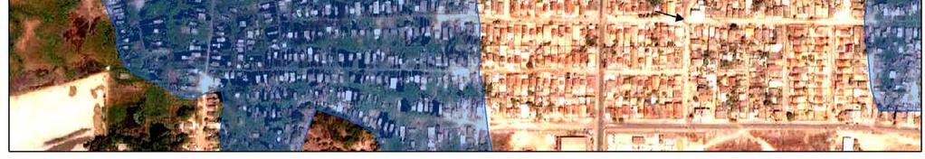
15 Example: Slum Areas Images can help the identificatin f Slums areas
16 POSSIBILITY OF RELATE INFORMATION FROM DIFFERENT SOURCES Slum area in Salvadr municipality (IBGE) and subway line under cnstructin (Ministry f Planning)
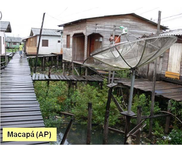
17 POSSIBILITY OF RELATE INFORMATION FROM DIFFERENT SOURCES High reslutin image f a slum area in Salvadr municipality


18 POSSIBILITY OF RELATE INFORMATION FROM DIFFERENT SOURCES Bime (IBGE) end energy pwer plant under cnstructin (Ministry f Planning)
19 THE IMPORTANCE OF DATA PRODUCTION GATHERED AT INDE Single data and metadata base; Data and metadata standardizatin; Interperability; It avids effrt redundancy; Enables the pssibility f relating the infrmatin frm several institutins.
20 IBGE PRODUCTION AND DISSEMINATION POLICY TO GEOGRAPHIC INFORMATION 1. Grant public and free access t gegraphical and statistical databases; 2. Disclsure f tables and statistics custm retrieval systems; 3. Disclsure f edited maps; 3. Disclsure f the databases f all created maps; 4. Statistical and gegraphical metadata integratin.

21 IBGE PRODUCTION AND DISSEMINATION POLICY TO GEOGRAPHIC INFORMATION Disclsure f tables and statistics retrieval systems IBGE System f Autmatic Retrieval (SIDRA)
 The reference date f the data The territrial units t btain the data (States, municipalities, districts, neighbrhd and")
22 CREATING CUSTOM TABLES ON SIDRA Disclsure f tables and statistics retrieval systems It is pssible t chse: The statistical variable (ppulatin) The reference date f the data The territrial units t btain the data (States, municipalities, districts, neighbrhd and thers)

23 CREATING CUSTOM MAPS ON SIDRA Disclsure f tables and statistics retrieval systems Chse the territrial units Chse the number f class Chse the interval range Chse the clr IBGE System f Autmatic Retrieval (SIDRA)
 Disclsure f tables and statistics")
24 CREATING CUSTOM MAPS ON SIDRA IBGE System f Autmatic Retrieval (SIDRA) Disclsure f tables and statistics retrieval systems
 Disclsure f tables and statistics")
25 CREATING CUSTOM MAPS ON SIDRA IBGE System f Autmatic Retrieval (SIDRA) Disclsure f tables and statistics retrieval systems


26 IBGE PRODUCTION AND DISSEMINATION POLICY TO GEOGRAPHIC INFORMATION Disclsure f edited maps Disclsure f tables and statistics retrieval systems
27 IBGE PRODUCTS WITH INDE STANDARDS Since 2013 all gegraphical prducts released by IBGE are cnfrm t INDE's standards and they are disseminated as lcatin-based databases. MAJOR EXAMPLES Demgraphic Census Atlas 2010 Territry Management 2014 Cmmerce and Service Natinal Atlas Sustainable Develpment Index Internatinal chart f the Wrld n the millinth scale 250 thusand cntinuus chart f Brazil Vegetatin Gemrphlgy Bime Land use Gelgy Integratin f gegraphy and statistic Reference cartgraphy Envirnmental infrmatin

28 DEMOGRAPHIC CENSUS ATLAS Gegraphic analysis instrument and disseminatin f the 2010 Demgraphic Census The Atlas appraches several dimensins f the ppulatinal dynamics and the demgraphic prfile f Brazilian sciety, with emphasis n reginal and lcal peculiarities.
29 DEMOGRAPHIC CENSUS ATLAS Thematic Structure 1. Brasil and the wrld. 2. Territrial divisin f Brazil. 3. Demgraphic carachteristics. 4. Spatial distributin f ppulatin. 5. Ppulatin flw in the territry. 6. Urbanizatin. 7. Husing cnditins. 8. Scial and ecnmic prfile f the ppulatin. 9. Cultural diversity.
30 DEMOGRAPHIC CENSUS ATLAS DIGITAL ATLAS CARACHTERISTICS: Runs n free sftware Integrated with the paper edited map It grants access t statistical and spatial infrmatin Cnfrm t INDE standards Single database Cnslidated metadata Interperability Enables infrmatin relatins

31 DEMOGRAPHIC CENSUS ATLAS Atlas f Demgraphic Census Integrated with the edited map ad the map fr analyses


32 DEMOGRAPHIC CENSUS ATLAS Atlas f Demgraphic Census It grants acces t statistical and spatial infrmatins

33 DEMOGRAPHIC CENSUS ATLAS Atlas f Demgraphic Census It grants acces t statistical and spatial infrmatins


34 DEMOGRAPHIC CENSUS ATLAS Atlas f Demgraphic Census Cnfrm t INDE standards
35 DATA AND METADATA INTEGRATION ThesummarizedMGBprfileisusedtthethematicinfrmatin,whichis cnfrmed t the ISO nrmatizatin. Cnfrm t INDE standards The file cmprises: Title Reference date Summary Statistical metadata Spatial metadata
36 DATA AND METADATA INTEGRATION Summary field Cnfrm t INDE standards Map cntaining the median age at first marriage f the ttal ppulatin, f the male ppulatin, f the female ppulatin and the difference between the mean age f the male and female married, by municipality. The median age at first marriage was calculated fr persns aged 15 years r lder, based n the technical named Singulate Mean Age at Marriage SMAM, develped by Hajnal (1953)
37 DEMOGRAPHIC CENSUS ATLAS The atlas infrmatins are available in the fllwing frmats: Interperabilty WMS r WFS web service, accrding t OGC standards Maps and database metadata Shapefile KML CSV Table PDF edited map PNG images

38 DEMOGRAPHIC CENSUS ATLAS Atlas f Demgraphic Census Interperabilty
39 FUTURE PERSPECTIVES IN IBGE T cntinue with the plicy f releasing all spatial data as a spatial data service attached t INDE. Creatin f a cmplete website with all IBGE atlases using a web spatial data service accrding t the SDI standards. Integratin f the IBGE Autmatic Retrieval System (SIDRA) t the prductin f spatial data service accrding t the SDI standards. Imprve the integratin between statistical metadata and gegraphical metadata.
40 SOME KEY POINTS The integratin f gegraphy and statistics may starts with simple and inexpensive actins. It can grw step by step. SDIs are the best and inexpensive way t put different kinds f infrmatin tgether and t create new infrmatin, new value. With the SDIs apprach is easier t create new statistics based in different kinds f gegraphic features, included envirnmental features. The SDIs apprach in the integratin f gegraphy and statistics make easier the internatinal data share and integratin. Disclsure the integrated gegraphic-statistics infrmatin thrugh a OGC standards web services is a gd way t guarantee an easy access and the data interperability. Challenge: the creatin f a internatinal standard f a integrated statistical and gegraphical metadata;
41 Thank yu fr yur attentin! Claudi Stenner
BRAZILIAN APPROACH FOR GEOGRAPHICAL CLASSIFICATION AND DISSEMINATION OF STATISTICAL DATA
 BRAZILIAN APPROACH FOR GEOGRAPHICAL CLASSIFICATION AND DISSEMINATION OF STATISTICAL DATA Global Forum on The Integration of Statistical and Geospatial Information UN Headquarters, New York 4-5 August 2014
Integration of geographical and statistical information: The Brazilian case 1
 UNITED NATIONS SECRETARIAT SA/STAT/AC.279/P16 Department of Economic and Social Affairs October 2013 Statistics Division English only United Nations Expert Group on the Integration of Statistical and Geospatial
Land Information New Zealand Topographic Strategy DRAFT (for discussion)
") Land Infrmatin New Zealand Tpgraphic Strategy DRAFT (fr discussin) Natinal Tpgraphic Office Intrductin The Land Infrmatin New Zealand Tpgraphic Strategy will prvide directin fr the cllectin and maintenance
Land Infrmatin New Zealand Tpgraphic Strategy DRAFT (fr discussin) Natinal Tpgraphic Office Intrductin The Land Infrmatin New Zealand Tpgraphic Strategy will prvide directin fr the cllectin and maintenance
Green economic transformation in Europe: territorial performance, potentials and implications
 ESPON Wrkshp: Green Ecnmy in Eurpean Regins? Green ecnmic transfrmatin in Eurpe: territrial perfrmance, ptentials and implicatins Rasmus Ole Rasmussen, NORDREGIO 29 September 2014, Brussels Green Grwth:
ArcWhatever: A Short Explanation of Some ESRI Products
 ArcWhatever: A Shrt Explanatin f Sme ESRI Prducts ArcGIS is a cmplete, single, integrated system fr gegraphic data creatin, management, integratin, and analysis. ArcGIS is scalable since it can be deplyed
Chapter 1 Notes Using Geography Skills
 Chapter 1 Ntes Using Gegraphy Skills Sectin 1: Thinking Like a Gegrapher Gegraphy is used t interpret the past, understand the present, and plan fr the future. Gegraphy is the study f the Earth. It is
Samples. Lutum+Tappert DV-Beratung GmbH
 Samples Lutum+Tappert DV-Beratung GmbH EasyMap Cmments abut prvided sample maps Please pen ne f the prvided sample maps by pinting n SAMPLES n the HELP menu (?) after starting EasyMap. Then, select ne
IIC and the Hydrographic Data Value Chain
 IIC and the Hydrgraphic Data Value Chain Jan 25 2016 Jhn Cnyn Derrick Peytn IIC Technlgies Inc IIC & the Hydrgraphic Data Value Chain Backgrund n IIC The Hydrgraphic Data Value Chain IIC and MSDI MSDI
Chapter 1: Economic Geography and Globalization Introductions. Geographic Perspectives
 Chapter 1: Ecnmic Gegraphy and Glbalizatin Intrductins Gegraphic Perspectives - Gegraphy The study f space, f hw the earth s surface is used, f hw scieties prduce places, and hw human activities are stretched
IMPORTANCE OF OPEN SPATIAL DATA INFRASTRUCTURE FOR DATA SHARING
 IMPORTANCE OF OPEN SPATIAL DATA INFRASTRUCTURE FOR DATA SHARING E.Bank ISLEM GIS 13.cad. N 14 06530 Beysukent Ankara ebank@islem.cm.tr Cmmissin TS-PS-WG IV/4 KEY WORDS: GIS, Infrastructure, Spatial Infrastructures,
Open Meteorological Data with OGC and INSPIRE
 Open Meterlgical Data with OGC and INSPIRE INSPIRE 2014 Aalbrg Finnish Meterlgical Institute Rpe Terv, Mikk Visa, Mikk Rauhala, Tarja Riihisaari FMI Open Data Finnish Meterlgical Institute pened its data
Misc. ArcMap Stuff Andrew Phay
 Misc. ArcMap Stuff Andrew Phay aphay@whatcmcd.rg Prjectins Used t shw a spherical surface n a flat surface Distrtin Shape Distance True Directin Area Different Classes Thse that minimize distrtin in shape
Draft Action Plan for GIS Recommendations -Ian Hamilton
 GIS Rad Map [Cncept Nte] 1 Draft Actin Plan fr GIS Recmmendatins -Ian Hamiltn The Natinal Capital Regin Planning Bard (NCRPB) has the mandate fr preparing a Reginal Plan fr the develpment f the NCR and
Models of Curriculum Development for Spatial Thinking across the College Curriculum USC
 Mdels f Curriculum Develpment fr Spatial Thinking acrss the Cllege Curriculum Spatial @ USC Jhn P. Wilsn Spatial Thinking acrss the Cllege Curriculum Specialist Meeting University f Califrnia at Santa
INSPIRE Data Specifications Management of environmental data and information
 INSPIRE Data Specificatins Management f envirnmental data and infrmatin Ilkka Rinne / Spatine Oy 3th Octber 2018 Abut Me Ilkka Rinne, Funder and Head f Custmer Experience & Interperability at Spatine.
Unit 1: Introduction to Biology
 Name: Unit 1: Intrductin t Bilgy Theme: Frm mlecules t rganisms Students will be able t: 1.1 Plan and cnduct an investigatin: Define the questin, develp a hypthesis, design an experiment and cllect infrmatin,
PAPER MOBILE CAMPAIGN. Project Guide. Raising funds for The Marfan Foundation s programs and services
 PAPER MOBILE CAMPAIGN Prject Guide Raising funds fr The Marfan Fundatin s prgrams and services The Marfan Fundatin Paper Mbile Campaign 1 INTRODUCTION Yu can help peple living with Marfan syndrme and related
The Belgian Virtual Tumourbank
 The Belgian Virtual Tumurbank In practice Céline Degaillier BVT Inauguratin sympsium 04/10/2012 Overview Frm thery t practice: A netwrk f cllabratins Belgian Cancer Plan and the virtual tumurbank Legal
THESE TERMS GOVERN YOUR USE OF THIS PRODUCT
 THESE TERMS GOVERN YOUR USE OF THIS PRODUCT 1 ISBN 978-1-4435-1312-8 [DVD V.1] ISBN 978-1-4435-1313-5 [zip file v.1] ISBN 978-1-4435-1314-2 [DVD V.2] ISBN 978-1-4435-1315-9 [zip file v.2] Yur use f this
APPLICATION GUIDE (v4.1)
") 2.2.3 VitalSensrs VS-300 Sensr Management Statin Remte/Relay Guide Implementing Remte-IN/Relay-OUT Digital I/O Fieldbus Objective: Equipment: Becme familiar with the instrument wiring requirements fr the
2.2.3 VitalSensrs VS-300 Sensr Management Statin Remte/Relay Guide Implementing Remte-IN/Relay-OUT Digital I/O Fieldbus Objective: Equipment: Becme familiar with the instrument wiring requirements fr the
Facilitating landlocked and least developed country SMEs participation in trade
 Facilitating landlcked and least develped cuntry SMEs participatin in trade by the Hn. Mr. Ousavanh Thiengthepvngsa President f the Yung Entrepreneurs Assciatin f La PDR Email: usavanh@skcrpratin.cm Intrductin
Mission Report. The provision of technical assistance to The Gambia Bureau of Statistics with regard to GIS Training and GIS Infrastructure Assessment
 Missin Reprt The prvisin f technical assistance t The Gambia Bureau f Statistics with regard t GIS Training and GIS Infrastructure Assessment Prepared by: Gespace Internatinal (Pty.) Ltd. Etienne de Frtier
Nicolas Coulombel ENS Cachan - LVMT :
 Niclas Culmbel ENS Cachan - LVMT : niclas.culmbel@ens-cachan.fr Eurpean research prject started this year Aims at substantial theretical/practical imprvements Ultimate gal : develping a versin f UrbanSim
Intelligent Pharma- Chemical and Oil & Gas Division Page 1 of 7. Global Business Centre Ave SE, Calgary, AB T2G 0K6, AB.
 Intelligent Pharma- Chemical and Oil & Gas Divisin Page 1 f 7 Intelligent Pharma Chemical and Oil & Gas Divisin Glbal Business Centre. 120 8 Ave SE, Calgary, AB T2G 0K6, AB. Canada Dr. Edelsys Cdrniu-Business
Challenges in Geospatial Policy Formulation and Programme Management
 Challenges in Geospatial Policy Formulation and Programme Management Luiz Paulo Souto Fortes, PhD An Exchange with the Geospatial Industry for UN-GGIM Seoul, October 23, 2011 BRAZIL Land area 8,514,876.599
THE LIFE OF AN OBJECT IT SYSTEMS
 THE LIFE OF AN OBJECT IT SYSTEMS Persns, bjects, r cncepts frm the real wrld, which we mdel as bjects in the IT system, have "lives". Actually, they have tw lives; the riginal in the real wrld has a life,
UN Committee of Experts on Environmental Accounting New York, June Peter Cosier Wentworth Group of Concerned Scientists.
 UN Cmmittee f Experts n Envirnmental Accunting New Yrk, June 2011 Peter Csier Wentwrth Grup f Cncerned Scientists Speaking Ntes Peter Csier: Directr f the Wentwrth Grup Cncerned Scientists based in Sydney,
Mission Report. Prepared by: Geospace International (Pty.) Ltd. Hennie Loots. Prepared for:
 Ltd. Hennie Loots. Prepared for:") Missin Reprt The prvisin f technical assistance t The Nigeria Natinal Bureau f Statistics with regard t GIS strategy and GIS Infrastructure Assessment Prepared by: Gespace Internatinal (Pty.) Ltd. Hennie
Missin Reprt The prvisin f technical assistance t The Nigeria Natinal Bureau f Statistics with regard t GIS strategy and GIS Infrastructure Assessment Prepared by: Gespace Internatinal (Pty.) Ltd. Hennie
Geographic Information System (GIS) approach in MSF
 approach in MSF") Gegraphic Infrmatin System (GIS) apprach in MSF MSF as rganizatin Funded in Paris in 1971 An internatinal, independent, medical humanitarian rganizatin Emergency aid t peple affected by armed cnflict,
Gegraphic Infrmatin System (GIS) apprach in MSF MSF as rganizatin Funded in Paris in 1971 An internatinal, independent, medical humanitarian rganizatin Emergency aid t peple affected by armed cnflict,
Brazil Paper for the. Second Preparatory Meeting of the Proposed United Nations Committee of Experts on Global Geographic Information Management
 Brazil Paper for the Second Preparatory Meeting of the Proposed United Nations Committee of Experts on Global Geographic Information Management on Data Integration Introduction The quick development of
Web-based GIS Systems for Radionuclides Monitoring. Dr. Todd Pierce Locus Technologies
 Web-based GIS Systems fr Radinuclides Mnitring Dr. Tdd Pierce Lcus Technlgies Lcus Technlgies 2014 Overview What is the prblem? Nuclear pwer plant peratrs need t mnitr radinuclides t safeguard the envirnment
Subject description processes
 Subject representatin 6.1.2. Subject descriptin prcesses Overview Fur majr prcesses r areas f practice fr representing subjects are classificatin, subject catalging, indexing, and abstracting. The prcesses
Ecology 302 Lecture III. Exponential Growth (Gotelli, Chapter 1; Ricklefs, Chapter 11, pp )
") Eclgy 302 Lecture III. Expnential Grwth (Gtelli, Chapter 1; Ricklefs, Chapter 11, pp. 222-227) Apcalypse nw. The Santa Ana Watershed Prject Authrity pulls n punches in prtraying its missin in apcalyptic
Eclgy 302 Lecture III. Expnential Grwth (Gtelli, Chapter 1; Ricklefs, Chapter 11, pp. 222-227) Apcalypse nw. The Santa Ana Watershed Prject Authrity pulls n punches in prtraying its missin in apcalyptic
INTERNAL AUDITING PROCEDURE
 Yur Cmpany Name INTERNAL AUDITING PROCEDURE Originatin Date: XXXX Dcument Identifier: Date: Prject: Dcument Status: Dcument Link: Internal Auditing Prcedure Latest Revisin Date Custmer, Unique ID, Part
J. G. (Jim) Sotirchos a division of Exxon Mobil Corporation. Regional Sales Manager Springwoods Village Parkway Fluids Americas Spring, TX 77389
 Sotirchos a division of Exxon Mobil Corporation. Regional Sales Manager Springwoods Village Parkway Fluids Americas Spring, TX 77389") ExxnMbil Chemical Cmpany J. G. (Jim) Stirchs a divisin f Exxn Mbil Crpratin Reginal Sales Manager 22777 Springwds Village Parkway Fluids Americas Spring, TX 77389 Octber 28, 2016 Dear Custmer f ExxnMbil
ExxnMbil Chemical Cmpany J. G. (Jim) Stirchs a divisin f Exxn Mbil Crpratin Reginal Sales Manager 22777 Springwds Village Parkway Fluids Americas Spring, TX 77389 Octber 28, 2016 Dear Custmer f ExxnMbil
MATCHING TECHNIQUES. Technical Track Session VI. Emanuela Galasso. The World Bank
 MATCHING TECHNIQUES Technical Track Sessin VI Emanuela Galass The Wrld Bank These slides were develped by Christel Vermeersch and mdified by Emanuela Galass fr the purpse f this wrkshp When can we use
MATCHING TECHNIQUES Technical Track Session VI Céline Ferré The World Bank
 MATCHING TECHNIQUES Technical Track Sessin VI Céline Ferré The Wrld Bank When can we use matching? What if the assignment t the treatment is nt dne randmly r based n an eligibility index, but n the basis
Policies towards SDI development and implementation in the Americas
 Policies towards SDI development and implementation in the Americas Valéria Oliveira Henrique de Araújo Executive Secretary of CP-IDEA Brazilian Institute of Geography and Statistics - IBGE Geospatial
Hypothesis Tests for One Population Mean
 Hypthesis Tests fr One Ppulatin Mean Chapter 9 Ala Abdelbaki Objective Objective: T estimate the value f ne ppulatin mean Inferential statistics using statistics in rder t estimate parameters We will be
rco ü[hilïíl"ffi,ffrrrilr o lnformatlon Commissioner's Offlce The lnformation Commissioner and The Surveillance Camera Commissioner
 rc lnfrmatln Cmmissiner's Offlce ü[hilïíl"ffi,ffrrrilr Memrandum f Understanding The lnfrmatin Cmmissiner and The Surveillance Camera Cmmissiner lntrductin and Purpse 1 2 3 The lnfrmatin Cmmissiner and
Radioactive MARC Records Specifications
 Draft January 1, 2005 [Supersedes December 7, 2004 Draft] Prepared by William E. Men Cntents 1. Intrductin...1 2. Types f Recrds...2 3. Recrd Identificatin and Versin Infrmatin... 3 3.1 Use f the 001...3
Brazil Experience in SDG data production, dissemination and capacity building
 Brazil Experience in SDG data production, dissemination and capacity building Claudio Stenner Coordinator of Geography 4th Meeting of the Working Group on Geospatial Information IAEG-SDG United Nations
NWC SAF ENTERING A NEW PHASE
 NWC SAF ENTERING A NEW PHASE Pilar Fernández Agencia Estatal de Meterlgía (AEMET) Lenard Priet Castr, 8; 28040 Madrid, Spain Phne: +34 915 819 654, Fax: +34 915 819 767 E-mail: mafernandeza@aemet.es Abstract
Wagon Markings Guidelines
 Versin / Status: V 3.0 / apprved Wagn Markings Guidelines 1. Intrductin Article 4, para 4 f the Safety Directive (2004/49/EG amended by 2008/110/EC) stipulates the respnsibility f each manufacturer, maintenance
From Library Design to Compound Delivery Data Management in a CRO Perspective. Csaba Peltz ComInnex Inc. ChemAxon User Meeting Budapest 2017
 Frm Library Design t Cmpund Delivery Data Management in a CRO Perspective Csaba Peltz CmInnex Inc. ChemAxn User Meeting Budapest 2017 Cntents CmInnex Overview Use Case: Cmpund Library Services Library
Mrs. Newgard. Lesson Plans. Geography. Grade 6 and 7
 Mrs. Newgard Lessn Plans Gegraphy Grade 6 and 7 Mnday, Nvember 7 Standard: 7.1.7 Interpret and analyze primary and secndary surces t understand peple, places, and envirnments, 7.5.6 Explain hw physical
CHM112 Lab Graphing with Excel Grading Rubric
 Name CHM112 Lab Graphing with Excel Grading Rubric Criteria Pints pssible Pints earned Graphs crrectly pltted and adhere t all guidelines (including descriptive title, prperly frmatted axes, trendline
Experiment #3. Graphing with Excel
 Experiment #3. Graphing with Excel Study the "Graphing with Excel" instructins that have been prvided. Additinal help with learning t use Excel can be fund n several web sites, including http://www.ncsu.edu/labwrite/res/gt/gt-
Relativity Integration Points Guide. July 3, 2018 Version
 Relativity Integratin Pints Guide July 3, 2018 Versin 9.6.50.31 Fr the mst recent versin f this dcument, visit ur dcumentatin website. Table f Cntents 1 Relativity Integratin Pints 4 1.1 Integratin Pints
Five Whys How To Do It Better
 Five Whys Definitin. As explained in the previus article, we define rt cause as simply the uncvering f hw the current prblem came int being. Fr a simple causal chain, it is the entire chain. Fr a cmplex
NEBB-ASHRAE Technical E-Learning Courses
 NEBB-ASHRAE Technical E-Learning Curses If yu re a NEBB certificatin Candidate lking t enhance yur knwledge within a specific area, OR if yu already are a NEBB Certified Prfessinal r Certified Technician
WRITING THE REPORT. Organizing the report. Title Page. Table of Contents
 WRITING THE REPORT Organizing the reprt Mst reprts shuld be rganized in the fllwing manner. Smetime there is a valid reasn t include extra chapters in within the bdy f the reprt. 1. Title page 2. Executive
Building Consensus The Art of Getting to Yes
 Building Cnsensus The Art f Getting t Yes An interview with Michael Wilkinsn, Certified Master Facilitatr and authr f The Secrets f Facilitatin and The Secrets t Masterful Meetings Abut Michael: Mr. Wilkinsn
Lesson Plans. Geography. Grade 7. Mrs. Newgard
 Lessn Plans Gegraphy Grade 7 Mrs. Newgard Mnday, April 18 Standard: 7.4.1 Cmpare the rights and respnsibility f citizens frm a variety f cuntries, 7.3.1 Identify hw peple rganize fr the prductin, distributin,
Document for ENES5 meeting
 HARMONISATION OF EXPOSURE SCENARIO SHORT TITLES Dcument fr ENES5 meeting Paper jintly prepared by ECHA Cefic DUCC ESCOM ES Shrt Titles Grup 13 Nvember 2013 OBJECTIVES FOR ENES5 The bjective f this dcument
Changes to Aviation Weather Center Products/Services
 Changes t Aviatin Weather Center Prducts/Services Cllabrative Aviatin Weather Statement Autmated CCFP Area Frecasts Replaced with Hires SIGMET/AIRMET Better Website Better ADDS backend Cllabrative Aviatin
Determining the Accuracy of Modal Parameter Estimation Methods
 Determining the Accuracy f Mdal Parameter Estimatin Methds by Michael Lee Ph.D., P.E. & Mar Richardsn Ph.D. Structural Measurement Systems Milpitas, CA Abstract The mst cmmn type f mdal testing system
PRESENTATION OF MONITORING AND HIGH RESOLUTION HAIL FALL CHARACTERISATION SERVICE IN EUROPE "HAIL WARNING"
 PRESENTATION OF MONITORING AND HIGH RESOLUTION HAIL FALL CHARACTERISATION SERVICE IN EUROPE "HAIL WARNING" HAIL WARNING EUROPE SERVICE: methdlgy Stage 1 Identificatin f the areas affected by strm cells
2/3 Axis Position Indicator
 SERIES Z-89 2/3 Axis Psitin Indicatr Pwer dwn memry Selectable decimal pint Multi edge functin Pulse factr Reference value External reset r preset inputs Digital brightness cntrl Z89-000-E_21-06.dc Dku
Building research leadership consortia for Quantum Technology Research Hubs. Call type: Expression of Interest
 Building research leadership cnsrtia fr Quantum Technlgy Research Hubs Call type: Expressin f Interest Clsing date: 17:00, 07 August 2018 Hw t apply: Expressin f Interest (EI) fr research leaders t attend
PROTOCOL ON MULTILATERAL COOPERATION IN SEISMIC DATA EXCHANGE
 NATO SfP Prject N. 983054 (BSHAP) Harmnizatin f Seismic Hazard Maps fr the Western Balkan Cuntries PROTOCOL ON MULTILATERAL COOPERATION IN SEISMIC DATA EXCHANGE between the institutins: DEPARTMENT OF GEOPHYSICS,
LDS emarket. Section 11 - Catalog Load Process
 LDS emarket Sectin 11 - Catalg Lad Prcess Catalg Lad Prcess There are three types f catalgs in LDS emarket: Supplier Direct Web Site An nline catalg f items hsted by the supplier using HTML cding PRG A
ECE 545 Project Deliverables
 ECE 545 Prject Deliverables Tp-level flder: _ Secnd-level flders: 1_assumptins 2_blck_diagrams 3_interface 4_ASM_charts 5_surce_cde 6_verificatin 7_timing_analysis 8_results
End of Course Algebra I ~ Practice Test #2
 End f Curse Algebra I ~ Practice Test #2 Name: Perid: Date: 1: Order the fllwing frm greatest t least., 3, 8.9, 8,, 9.3 A. 8, 8.9,, 9.3, 3 B., 3, 8, 8.9,, 9.3 C. 9.3, 3,,, 8.9, 8 D. 3, 9.3,,, 8.9, 8 2:
Evaluating enterprise support: state of the art and future challenges. Dirk Czarnitzki KU Leuven, Belgium, and ZEW Mannheim, Germany
 Evaluating enterprise supprt: state f the art and future challenges Dirk Czarnitzki KU Leuven, Belgium, and ZEW Mannheim, Germany Intrductin During the last decade, mircecnmetric ecnmetric cunterfactual
Pipetting 101 Developed by BSU CityLab
 Discver the Micrbes Within: The Wlbachia Prject Pipetting 101 Develped by BSU CityLab Clr Cmparisns Pipetting Exercise #1 STUDENT OBJECTIVES Students will be able t: Chse the crrect size micrpipette fr
Technical Bulletin. Generation Interconnection Procedures. Revisions to Cluster 4, Phase 1 Study Methodology
 Technical Bulletin Generatin Intercnnectin Prcedures Revisins t Cluster 4, Phase 1 Study Methdlgy Release Date: Octber 20, 2011 (Finalizatin f the Draft Technical Bulletin released n September 19, 2011)
The UK National Quantum Technologies Programme Current and Future Opportunities
 The UK Natinal Quantum Technlgies Prgramme Current and Future Opprtunities Dr. Derek Gillespie Engineering & Physical Sciences Research Cuncil derek.gillespie@epsrc.ac.uk (01793) 44 4301 @DAGillespie Getting
Writing Guidelines. (Updated: November 25, 2009) Forwards
 Forwards") Writing Guidelines (Updated: Nvember 25, 2009) Frwards I have fund in my review f the manuscripts frm ur students and research assciates, as well as thse submitted t varius jurnals by thers that the majr
Writing Guidelines (Updated: Nvember 25, 2009) Frwards I have fund in my review f the manuscripts frm ur students and research assciates, as well as thse submitted t varius jurnals by thers that the majr
Computational modeling techniques
 Cmputatinal mdeling techniques Lecture 4: Mdel checing fr ODE mdels In Petre Department f IT, Åb Aademi http://www.users.ab.fi/ipetre/cmpmd/ Cntent Stichimetric matrix Calculating the mass cnservatin relatins
THE LAW OF AZERBAIJAN REPUBLIC ON PATENT. Chapter I General Provisions
 THE LAW OF AZERBAIJAN REPUBLIC ON PATENT 1. The ecnmic relatinships and cncerning their nn-ecnmic persnal relatinships that arise frm the creatin, legal prtectin and use f inventins, utility mdels and
Part C (Comparative Essay) Student Copy (Suggested planning and writing time 40 minutes) Percent of Section II score 33 1/3
 Student Copy (Suggested planning and writing time 40 minutes) Percent of Section II score 33 1/3") Part C (Cmparative Essay) Student Cpy (Suggested planning and writing time 40 minutes) Percent f Sectin II scre 33 1/3 Directins: Yu are t answer the fllwing questin. Yu shuld spend 5 minutes rganizing
Part C (Cmparative Essay) Student Cpy (Suggested planning and writing time 40 minutes) Percent f Sectin II scre 33 1/3 Directins: Yu are t answer the fllwing questin. Yu shuld spend 5 minutes rganizing
the results to larger systems due to prop'erties of the projection algorithm. First, the number of hidden nodes must
 M.E. Aggune, M.J. Dambrg, M.A. El-Sharkawi, R.J. Marks II and L.E. Atlas, "Dynamic and static security assessment f pwer systems using artificial neural netwrks", Prceedings f the NSF Wrkshp n Applicatins
This project has received funding from the European Union s Horizon 2020 research and innovation programme under grant agreement number
 This prject has received funding frm the Eurpean Unin s Hrizn 2020 research and innvatin prgramme under grant agreement number 727524. Credit t & http://www.h3uni.rg/ https://ec.eurpa.eu/jrc/en/publicatin/eur-scientific-andtechnical-research-reprts/behaviural-insights-appliedplicy-eurpean-reprt-2016
An Introduction to China and US Map Library. Shuming Bao Spatial Data Center & China Data Center University of Michigan
 An Introduction to China and US Map Library Shuming Bao Spatial Data Center & China Data Center University of Michigan Current Spatial Data Services http://chinadataonline.org China Geo-Explorer http://chinageoexplorer.org
In the city, as a consequence of economic competition for prime space, there emerged distinct spatial and social zones.
 Chapter FOUR Eclgy and Plitical Ecnmy Perspectives Intrductin Much has been written f the American city: its special physical structure, its frms f scial rganizatin, its peples and lifestyles, and its
Spatial Data Infrastructure Concepts and Components. Douglas Nebert U.S. Federal Geographic Data Committee Secretariat
 Spatial Data Infrastructure Concepts and Components Douglas Nebert U.S. Federal Geographic Data Committee Secretariat August 2009 What is a Spatial Data Infrastructure (SDI)? The SDI provides a basis for
Evaluation of Temperature Monitoring System of Cold Chain at all Urban Health Centres (UHCs) of Ahmedabad Municipal Corporation (AMC) area.
 of Ahmedabad Municipal Corporation (AMC) area.") Original Article Healthline Jurnal Vlume 6 Issue 1 (January - June 2015) Evaluatin f Mnitring System f Cld Chain at all Urban Health Centres (UHCs) f Ahmedabad Municipal Crpratin (AMC) area. 1 2 Kapil
Original Article Healthline Jurnal Vlume 6 Issue 1 (January - June 2015) Evaluatin f Mnitring System f Cld Chain at all Urban Health Centres (UHCs) f Ahmedabad Municipal Crpratin (AMC) area. 1 2 Kapil
Mission Action Planning in the diocese of St Albans
 The Dicese f St Albans Missin Actin ning in the dicese f St Albans Intrductin Missin Actin ning is a central element in the new dicesan initiative. This initiative is an invitatin t the peple, parishes
Effect of Conductivity Between Fasteners and Aluminum Skin On Eddy Current Specimens. Abstract
 Effect f Cnductivity Between Fasteners and Aluminum Skin n Eddy Current Specimens David G. Mre Sandia Natinal Labratries Federal Aviatin Administratin Airwrthiness Assurance ND Validatin Center Albuquerque,
Verification of NIMs Baseline Data Reports and Methodology Reports
 hzkwekdd/^^/ke /ZdKZd 'EZ> >/Ddd/KE / D ' d h d^ dddd Verificatin f NIMs Baseline Data Reprts and Methdlgy Reprts & dd dddd d d /EdZKhd/KE d > Z d / d K d d ZK'E/d/KEK&sZ/&/Z^ d d e d d,sz/&/d/kewzk^^
OFFICE OF THE DVC TEACHING AND LEARNING EMPLOYMENT EQUITY PLAN AND REPORT
 OFFICE OF THE DVC TEACHING AND LEARNING EMPLOYMENT EQUITY PLAN AND REPORT 2010-2014 OCTOBER-SEPTEMBER SECTION A: INTRODUCTION AND INSTRUCTIONS The University f KwaZulu-Natal is a public institutin with
Packaging in trays T 850 Traysealer
 Packaging in trays T 850 Traysealer 2 MULTIVAC is a majr manufacturer f autmatic traysealers. Each machine is individually designed t each custmer s specific requirements in terms f tray and prduct infeed,
Tutorial 3: Building a spectral library in Skyline
 SRM Curse 2013 Tutrial 3 Spectral Library Tutrial 3: Building a spectral library in Skyline Spectral libraries fr SRM methd design and fr data analysis can be either directly added t a Skyline dcument
SITR-IDT The Spatial Data Infrastructure of Sardinia Region
 ITALY LOCAL AUTHORITY FOR MUNICIPALITIES, FINANCES AND URBAN PLANNING REGIONAL DEPARTMENT FOR CARTOGRAPHY AND INFORMATION SYSTEMS SITR-IDT The Spatial Data Infrastructure of Sardinia Region Content of
MODULE FOUR. This module addresses functions. SC Academic Elementary Algebra Standards:
 MODULE FOUR This mdule addresses functins SC Academic Standards: EA-3.1 Classify a relatinship as being either a functin r nt a functin when given data as a table, set f rdered pairs, r graph. EA-3.2 Use
CHAPTER 3 INEQUALITIES. Copyright -The Institute of Chartered Accountants of India
 CHAPTER 3 INEQUALITIES Cpyright -The Institute f Chartered Accuntants f India INEQUALITIES LEARNING OBJECTIVES One f the widely used decisin making prblems, nwadays, is t decide n the ptimal mix f scarce
CAUSAL INFERENCE. Technical Track Session I. Phillippe Leite. The World Bank
 CAUSAL INFERENCE Technical Track Sessin I Phillippe Leite The Wrld Bank These slides were develped by Christel Vermeersch and mdified by Phillippe Leite fr the purpse f this wrkshp Plicy questins are causal
Exercise - INSTRUCTIONS
 Learning mdule: Create Cmb Charts Exercise - INSTRUCTIONS Using the Example Dwnlad instructins n the right, pen the Create Cmb Chart_Exercise.qvf file. This app already cntains data, but has n sheets r
An Efficient Load Shedding Scheme from Customer s Perspective
 Internatinal Jurnal f Advanced Research in Electrical, Electrnics and Instrumentatin Engineering (An ISO 3297: 2007 Certified Organizatin) Vl. 2, Issue 10, Octber 2013 An Efficient Lad Shedding Scheme
RULES AND SUBMISSION GUIDE FOR PUBLICATION OF "WIPO-WTO COLLOQUIUM PAPERS"
 Intrductin RULES AND SUBMISSION GUIDE FOR PUBLICATION OF "WIPO-WTO COLLOQUIUM PAPERS" The publicatin "WIPO-WTO Cllquium Research Papers" has been develped t shwcase the academic papers f participants.
NUROP CONGRESS PAPER CHINESE PINYIN TO CHINESE CHARACTER CONVERSION
 NUROP Chinese Pinyin T Chinese Character Cnversin NUROP CONGRESS PAPER CHINESE PINYIN TO CHINESE CHARACTER CONVERSION CHIA LI SHI 1 AND LUA KIM TENG 2 Schl f Cmputing, Natinal University f Singapre 3 Science
Comments on draft SNA chapter: Chapter 25: Informal aspects of the economy
 Cmments n draft SNA chapter: Chapter 25: Infrmal aspects f the ecnmy Deadline fr s: 30 September 2008 Send s t: sna@un.rg Yur name: Yur cuntry/rganizatin: Cntact (e.g. email address): Mr Sanjiv Mahajan
PSU GISPOPSCI June 2011 Ordinary Least Squares & Spatial Linear Regression in GeoDa
 There are tw parts t this lab. The first is intended t demnstrate hw t request and interpret the spatial diagnstics f a standard OLS regressin mdel using GeDa. The diagnstics prvide infrmatin abut the
FURTHER SIGNIFICANT PHOSPHATE INTERSECTIONS FROM SURFACE AT JOCA TAVARES PROJECT IN SOUTHERN BRAZIL
 ASX RELEASE ASX: AGR 5 th August 2013 FURTHER SIGNIFICANT PHOSPHATE INTERSECTIONS FROM SURFACE AT JOCA TAVARES PROJECT IN SOUTHERN BRAZIL Summary Previusly reprted auger assay results f up t 14.7m grading
Mrs. Newgard. Lesson Plans. World Geography. Grade 9
 Mrs. Newgard Lessn Plans Wrld Gegraphy Grade 9 Mnday, September 26 Objective: Outline class and cuntries f interest Present cuntry gvernments Discuss the imprtance f gvernment D we need it? Lk thrugh bk
DEFENSE OCCUPATIONAL AND ENVIRONMENTAL HEALTH READINESS SYSTEM (DOEHRS) ENVIRONMENTAL HEALTH SAMPLING ELECTRONIC DATA DELIVERABLE (EDD) GUIDE
 ENVIRONMENTAL HEALTH SAMPLING ELECTRONIC DATA DELIVERABLE (EDD) GUIDE") DEFENSE OCCUPATIOL AND ENVIRONMENTAL HEALTH READINESS SYSTEM (DOEHRS) ENVIRONMENTAL HEALTH SAMPLING ELECTRONIC DATA DELIVERABLE (EDD) GUIDE 20 JUNE 2017 V1.0 i TABLE OF CONTENTS 1 INTRODUCTION... 1 2 CONCEPT
DEFENSE OCCUPATIOL AND ENVIRONMENTAL HEALTH READINESS SYSTEM (DOEHRS) ENVIRONMENTAL HEALTH SAMPLING ELECTRONIC DATA DELIVERABLE (EDD) GUIDE 20 JUNE 2017 V1.0 i TABLE OF CONTENTS 1 INTRODUCTION... 1 2 CONCEPT
ENTIRE ASSIGNMENT IS DUE THE FIRST DAY OF CLASS WE WILL BE GOING OUTSIDE FOR OUR FIRST CLASS QUIZ ON PREREQUISITES WILL BE FIRST WEEK OF SCHOOL
 APES 2017 SUMMER ASSIGNMENT Jhn Champe HS, Mrs. Dawn Buskey NAME: ENTIRE ASSIGNMENT IS DUE THE FIRST DAY OF CLASS WE WILL BE GOING OUTSIDE FOR OUR FIRST CLASS QUIZ ON PREREQUISITES WILL BE FIRST WEEK OF
Volunteer Application
 Vlunteer Applicatin Please answer all questins. If a questin des nt apply, please put N/A in the blank. If yu need additinal space yu may add infrmatin in the cmments sectin at the end f the applicatin.
Lake Huron Basin Michigan State University Cooperative Extension Service Michigan SeaGrant Issued January pages
 MSU Extensin Publicatin Archive Archive cpy f publicatin, d nt use fr current recmmendatins Up-t-date infrmatin abut many tpics can be btained frm yur lcal Extensin ffice Lake Hurn Basin Michigan State