An Introduction to China and US Map Library. Shuming Bao Spatial Data Center & China Data Center University of Michigan
|
|
|
- Angel Cameron
- 5 years ago
- Views:
Transcription
1 An Introduction to China and US Map Library Shuming Bao Spatial Data Center & China Data Center University of Michigan

2 Current Spatial Data Services China Geo-Explorer US Geo-Explorer Free Mapping Online


3 China and US Geo-Explorers Integrating Statistics and GIS into Powerful Tools for Spatial Analysis Statistics Data Output Graphs Tables Reports Census GIS Modules Maps PySAL StatGL


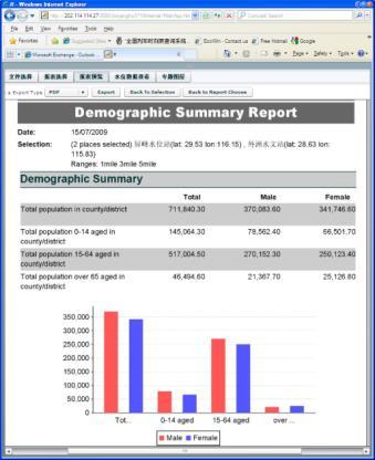
4 China Geo-Explorer with more than 6,500 variables on demographic & business


5 US Geo-Explorer with more than 45,000 variables on demographic & business


6 Free Mapping Online Free mapping tool for US and China data

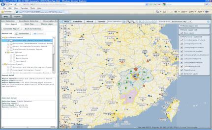
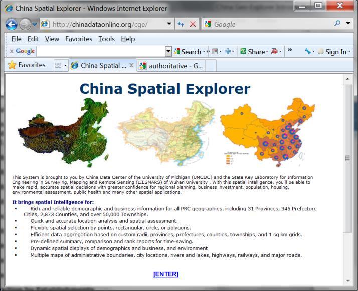
7 China & US Map Library
8 Features of China & US Map Library Flexible search (place, date range, keywords) Pre-classified maps with customized options Direct linkage between maps of different administrative levels (state->county->tract->block) Easy switch between maps of different classifications (county map: tract, county division, block, place) Complete metadata (map title, subject, source, citation) Unique link to each map (Map-ID: abf10lt501001) Multiple outputs (data: Excel, CSV; map: PDF, PNG) Compatible with most platforms (computer, cellphone) No software installation required (web access)
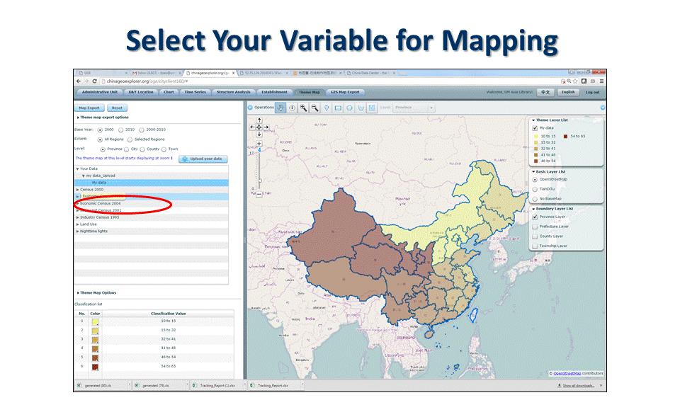
9 Base Data: China Population Census (2010) Population Census (2000) Economic Census (2008) Economic Census (2004) Basic Unit Census (2001) Industrial Census (1995) Land Use Data (1990, 1995, 2000, 2005, 2010) Nighttime Light Data (1992-)
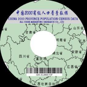
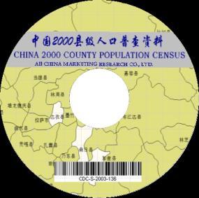
10 Population Census Data with GIS Maps Released by China Data Center 2000 Province Census Data with GIS Maps 2000 City Census Data with GIS Maps 2000 County Census Data with GIS Maps 2000 Township Census Data with GIS Maps 2010 Province Census Data with GIS Maps 2010 City Census Data with GIS Maps 2010 County Census Data with GIS Maps 2010 Township Census Data with GIS Maps Province Census Data with GIS Maps City Census Data with GIS Maps County Census Data with GIS Maps
11 Population Census Data of China > 2,000 demographic variables in population Census Geographical Levels: Country Province Prefecture County Township Census data variables: General Information Nationalities Age Structure Household Structure Education Fertility Deaths Marriage Migration Housing Status Industries and Occupations
12 Economic Census Data with GIS Maps Released by China Data Center 2008 Province Economic Census Data with GIS Maps 2008 City Economic Census Data with GIS Maps 2008 County Economic Census Data with GIS Maps 2004 Province Census Data with GIS Maps 2004 City Census Data with GIS Maps 2004 County Census Data with GIS Maps 2001 Province Census Data with GIS Maps 2001 City Census Data with GIS Maps 2001 County Census Data with GIS Maps 1995 Province Industrial Census Data with GIS Maps 1995 City Industrial Census Data with GIS Maps 1995 County Industrial Census Data with GIS Maps
13 Base Data: U.S. Population Census (1970, 1980, 1990, 2000, 2010) State, Metropolitan, County, County Division, Place, Tract, Block Economic Census (1986-) State, Metropolitan, County Business Data with GIS Maps (1997- ) State, Metropolitan, County, County Division Presidential Election (2016) State, Metropolitan, County
14 Base Maps of US and China China boundary maps (2000 and 2010): o Province o Prefecture City o County and Urban District o Township (approximated boundary) U.S. boundary maps ( ): o State o Metropolitan o County o County Division o Place o Tract o Block

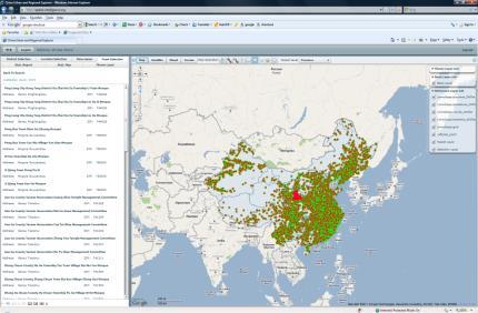
15 Demo: US Map Library Online Search Keywords Date Place Level Source Region


16 Demo: List of Search Results (Maps) Map Counts List of Search Results Sources

17 Demo: Country Map by State Edit Title Customized Options Map Options Multiple Outputs: Select a State:

18 Map of Tennessee by County Select a County Matadata: Subject, Source, Citation Unique Map-ID


19 Demo: Maps of Anderson County, TN Tract County Division Block Place

20 Excel Table Multiple Outputs Map in PDF Map in PNG

21 Links to China & US Geo-Explorers
22 Total Counts of US and China Maps U.S.A. Map Counts Nation (state, metropolitan, county) 230,587 State (county, county division) 5,647,604 Metropolitan (county) 32,037,869 County (tract, county division, block, place) 139,459,383 Total Counts 177,375,443 P.R. China (Mainland) Map Counts Nationa (Province, County) Province (City, County) 369,619 City (County, Township) 2,332,518 County (Township) 4,980,216 Total Counts 7,696,396 Note: the total counts in the table are based on the current statistics on Jan 19, 2017
23 Access: Free & Fee Based Free access: China: National maps (census 2000) Jiangxi province (all sources) US: National maps (Census ) Wyoming state (all sources) Fee based access: Library subscription Individual subscription One time purchase with life-time online access
24 Future Directions Expand to more data coverage Expand to more countries and regions Allow users to share maps (links) with others Allow users to build their own map libraries
647-9610")
25 China Data Online Spatial Data Center & China Data Center T: (734)
26 QUESTIONS?
A Case Study of Regional Dynamics of China 中国区域动态案例研究
 A Case Study of Regional Dynamics of China 中国区域动态案例研究 Shuming Bao Spatial Data Center & China Data Center University of Michigan 1:00 PM - 2:00 PM, Tue, Feb 6, 2018 EST USA A Case Study of Regional Dynamics
Understanding China Census Data with GIS By Shuming Bao and Susan Haynie China Data Center, University of Michigan
 Understanding China Census Data with GIS By Shuming Bao and Susan Haynie China Data Center, University of Michigan The Census data for China provides comprehensive demographic and business information
Using American Factfinder
 Using American Factfinder What is American Factfinder? American Factfinder is a search engine that provides access to the population, housing and economic data collected by the U.S. Census Bureau. It can
Techniques for Science Teachers: Using GIS in Science Classrooms.
 Techniques for Science Teachers: Using GIS in Science Classrooms. After ESRI, 2008 GIS A Geographic Information System A collection of computer hardware, software, and geographic data used together for
Demographic Data in ArcGIS. Harry J. Moore IV
 Demographic Data in ArcGIS Harry J. Moore IV Outline What is demographic data? Esri Demographic data - Real world examples with GIS - Redistricting - Emergency Preparedness - Economic Development Next
Lessons Learned from the production of Gridded Population of the World Version 4 (GPW4) Columbia University, CIESIN, USA EFGS October 2014
 Columbia University, CIESIN, USA EFGS October 2014") Lessons Learned from the production of Gridded Population of the World Version 4 (GPW4) Columbia University, CIESIN, USA EFGS October 2014 Gridded Population of the World Gridded (raster) data product
Lessons Learned from the production of Gridded Population of the World Version 4 (GPW4) Columbia University, CIESIN, USA EFGS October 2014 Gridded Population of the World Gridded (raster) data product
Spatial Organization of Data and Data Extraction from Maptitude
 Spatial Organization of Data and Data Extraction from Maptitude N. P. Taliceo Geospatial Information Sciences The University of Texas at Dallas UT Dallas GIS Workshop Richardson, TX March 30 31, 2018 1/
Globally Estimating the Population Characteristics of Small Geographic Areas. Tom Fitzwater
 Globally Estimating the Population Characteristics of Small Geographic Areas Tom Fitzwater U.S. Census Bureau Population Division What we know 2 Where do people live? Difficult to measure and quantify.
Working with Census Operations Case Study from KSA
 Working with Census Operations Case Study from KSA International Workshop on Integrating Geospatial and Statistical Information Beijing 9 12 June 2014 Abdullah M.Alhamlan Kingdom of Saudi Arabia Central
UNCERTAINTY IN THE POPULATION GEOGRAPHIC INFORMATION SYSTEM
 UNCERTAINTY IN THE POPULATION GEOGRAPHIC INFORMATION SYSTEM 1. 2. LIU De-qin 1, LIU Yu 1,2, MA Wei-jun 1 Chinese Academy of Surveying and Mapping, Beijing 100039, China Shandong University of Science and
CentropeSTATISTICS Working Interactively with Cross-Border Statistic Data Clemens Beyer, Walter Pozarek, Manfred Schrenk
 Clemens Beyer, Walter Pozarek, Manfred Schrenk (Dipl.-Ing. Clemens Beyer, CEIT ALANOVA, Concorde Business Park 2/F, 2320 Schwechat, Austria, c.beyer@ceit.at) (Dipl.-Ing. Walter Pozarek, PGO Planungsgemeinschaft
What are we like? Population characteristics from UK censuses. Justin Hayes & Richard Wiseman UK Data Service Census Support
 What are we like? Population characteristics from UK censuses Justin Hayes & Richard Wiseman UK Data Service Census Support Who are we? Richard Wiseman UK Data Service / Jisc Justin Hayes UK Data Service
Integrating Official Statistics and Geospatial Information NBS Experience
 Integrating Official Statistics and Geospatial Information NBS Experience Presented by Eng. Reda AL Sabbagh Director of IT Dept. Prepared by Eng. Adham Makky GIS Specialist Topics to be covered: Background
GRID map of Household and Population data in Kosovo. European Forum for Geostatistics, 5 7 October 2009, in The Hague, Netherlands
 GRID map of Household and Population data in Kosovo European Forum for Geostatistics, 5 7 October 2009, in The Hague, Netherlands SUMMARY Introduction Data sources Methods Results, & Maps WebGIS Description
Boundary and Annexation Survey (BAS)
") Boundary and Annexation Survey (BAS) New Mexico SDC Meeting Chris Wingate Geography Division U.S. Census Bureau 1 Agenda Boundary and Annexation Survey (BAS) BAS Overview American Community Survey (ACS)
Boundary and Annexation Survey (BAS) New Mexico SDC Meeting Chris Wingate Geography Division U.S. Census Bureau 1 Agenda Boundary and Annexation Survey (BAS) BAS Overview American Community Survey (ACS)
Acknowledgments xiii Preface xv. GIS Tutorial 1 Introducing GIS and health applications 1. What is GIS? 2
 Acknowledgments xiii Preface xv GIS Tutorial 1 Introducing GIS and health applications 1 What is GIS? 2 Spatial data 2 Digital map infrastructure 4 Unique capabilities of GIS 5 Installing ArcView and the
The History Behind Census Geography
 The History Behind Census Geography Michael Ratcliffe Geography Division US Census Bureau Kentucky State Data Center Affiliate Meeting August 5, 2016 Today s Presentation A brief look at the history behind
SPATIAL ANALYSIS OF POPULATION DATA BASED ON GEOGRAPHIC INFORMATION SYSTEM
 SPATIAL ANALYSIS OF POPULATION DATA BASED ON GEOGRAPHIC INFORMATION SYSTEM Liu, D. Chinese Academy of Surveying and Mapping, 16 Beitaiping Road, Beijing 100039, China. E-mail: liudq@casm.ac.cn ABSTRACT
Gridded Population of the World Version 4 (GPWv4)
") Gridded Population of the World Version 4 (GPWv4) Greg Yetman Chris Small Erin Doxsey-Whitfield Kytt MacManus May 28, 2015 Global Urbanization Workshop http://sedac.ciesin.columbia.edu 1 Focus on applying
Gridded Population of the World Version 4 (GPWv4) Greg Yetman Chris Small Erin Doxsey-Whitfield Kytt MacManus May 28, 2015 Global Urbanization Workshop http://sedac.ciesin.columbia.edu 1 Focus on applying
Map your way to deeper insights
 Map your way to deeper insights Target, forecast and plan by geographic region Highlights Apply your data to pre-installed map templates and customize to meet your needs. Select from included map files
Bentley Map Advancing GIS for the World s Infrastructure
 Bentley Map Advancing GIS for the World s Infrastructure Presentation Overview Why would you need Bentley Map? What is Bentley Map? Where is Bentley Map Used? Why would you need Bentley Map? Because your
The History Behind Census Geography
 The History Behind Census Geography Michael Ratcliffe Geography Division US Census Bureau Tennessee State Data Center August 8, 2017 Today s Presentation A brief look at the history behind some of the
The econ Planning Suite: CPD Maps and the Con Plan in IDIS for Consortia Grantees Session 1
 The econ Planning Suite: CPD Maps and the Con Plan in IDIS for Consortia Grantees Session 1 1 Training Objectives Use CPD Maps to analyze, assess, and compare levels of need in your community Use IDIS
Spatial Statistical Information Services in KOSTAT
 Distr. GENERAL WP.30 12 April 2010 ENGLISH ONLY UNITED NATIONS ECONOMIC COMMISSION FOR EUROPE (UNECE) CONFERENCE OF EUROPEAN STATISTICIANS EUROPEAN COMMISSION STATISTICAL OFFICE OF THE EUROPEAN UNION (EUROSTAT)
Technical Documentation Demostats april 2018
 Technical Documentation Demostats 2018 april 2018 what it is DemoStats is a database of estimates and projections for a comprehensive set of demographic and socioeconomic attributes about the Canadian
Preparing Spatial Data
 13 CHAPTER 2 Preparing Spatial Data Assessing Your Spatial Data Needs 13 Assessing Your Attribute Data 13 Determining Your Spatial Data Requirements 14 Locating a Source of Spatial Data 14 Performing Common
LandScan Global Population Database
 LandScan Global Population Database The World s Finest Population Distribution Data Uncommon information. Extraordinary places. LandScan Global Population Database East View Cartographic is now offering
Working with Census 2000 Data from MassGIS
 Tufts University GIS Tutorial Working with Census 2000 Data from MassGIS Revised September 26, 2007 Overview In this tutorial, you will use pre-processed census data from Massachusetts to create maps of
June 19 Huntsville, Alabama 1
 June 19 Huntsville, Alabama 1 Real-Time Geospatial Data: The Fusion of PI and ArcGIS Enabling Smarter Facilities Management OSIsoft and Esri Mapping and Location Analytics Platform Supporting Your Use
The Spatial Structure of Cities: International Examples of the Interaction of Government, Topography and Markets
 Module 2: Spatial Analysis and Urban Land Planning The Spatial Structure of Cities: International Examples of the Interaction of Government, Topography and Markets Alain Bertaud Urbanist Summary What are
GIS Level 2. MIT GIS Services
 GIS Level 2 MIT GIS Services http://libraries.mit.edu/gis Email: gishelp@mit.edu TOOLS IN THIS WORKSHOP - Definition Queries - Create a new field in the attribute table - Field Calculator - Add XY Data
Oman NSDI Supporting Economic Development. Saud Al-Nofli Director of Spatial Data Directorate General of NSDI, NCSI
 Oman NSDI Supporting Economic Development 2017 Saud Al-Nofli Director of Spatial Data Directorate General of NSDI, NCSI "It s critical to make correct decisions the first time to optimize the Investments
Visualizing Census Data in GIS. Andrew Rowan, Ph.D. Director, NJ Office of GIS
 Visualizing Census Data in GIS Andrew Rowan, Ph.D. Director, NJ Office of GIS Outline VERY accelerated cartography primer Software choices Demos/how-to ArcGIS Desktop (formerly ArcView) ArcGIS Online Notes
2010 Census Data Release and Current Geographic Programs. Michaellyn Garcia Geographer Seattle Regional Census Center
 2010 Census Data Release and Current Geographic Programs Michaellyn Garcia Geographer Seattle Regional Census Center 2010 Center of Population Located approximately 2.7 miles northeast of Plato, Missouri
Census Transportation Planning Products (CTPP)
") Census Transportation Planning Products (CTPP) Penelope Weinberger CTPP Program Manager - AASHTO September 15, 2010 1 What is the CTPP Program Today? The CTPP is an umbrella program of data products, custom
Census Transportation Planning Products (CTPP) Penelope Weinberger CTPP Program Manager - AASHTO September 15, 2010 1 What is the CTPP Program Today? The CTPP is an umbrella program of data products, custom
Zagreb Spatial Data Infrastructure. Sanja Batić, APIS IT Split, 14. rujna 2011.
 Zagreb Spatial Data Infrastructure Sanja Batić, APIS IT Split, 14. rujna 2011. Agenda Zagreb Spatial Data Infrastructure - ZIPP Guidelines for further ZIPP Geoportal development Conclusion 1964 The Centre
METADATA. Publication Date: Fiscal Year Cooperative Purchase Program Geospatial Data Presentation Form: Map Publication Information:
 METADATA CONTOURS Digital Geospatial Metadata: North Central Texas Orthophotography Identification Information Citation Originator: Publication Date: Fiscal Year 2001-2002 Title: Cooperative Purchase Program
Regionalizing and Understanding Commuter Flows: An Open Source Geospatial Approach
 Regionalizing and Understanding Commuter Flows: An Open Source Geospatial Approach Lorraine Barry School of Natural and Built Environment, Queen's University Belfast l.barry@qub.ac.uk January 2017 Summary
BROADBAND DEMAND AGGREGATION: PLANNING BROADBAND IN RURAL NORTHERN CALIFORNIA
 BROADBAND DEMAND AGGREGATION: PLANNING BROADBAND IN RURAL NORTHERN CALIFORNIA Steven J. Steinberg, Ph.D a,b, *, Rebecca Degagne a, M.S., Michael Gough a a Institute for Spatial Analysis, Humboldt State
LiDAR User Data Needs Survey Results
 LiDAR User Data Needs Survey Results June 2012 Introduction The Minnesota Geospatial Information Office (MnGeo) is working with the Minnesota Department of Natural Resources (DNR) to develop a data distribution
Google Maps and Beyond
 Google Maps and Beyond Aaron Paul First American Title apaul@firstam.com 2015 APRA Symposium Association of Professional Reserve Analysts May 2 nd, 2015 Google Maps and Beyond - Overview Business case
 www.goldensoftware.com Why Create a Thematic Map? A thematic map visually represents the geographic distribution of data. MapViewer will help you to: understand demographics define sales or insurance territories
Esri Maps for Office
 2013 Europe, Middle East, and Africa User Conference October 23-25, 2013 Munich, Germany Maps for Office Tony Howser Technical Product Manager Agenda Location Analytics Maps for Office 2.1.2 Road Ahead
A User s Guide to the Federal Statistical Research Data Centers
 A User s Guide to the Federal Statistical Research Data Centers Mark Roberts Professor of Economics and Director PSU FSRDC September 2016 M. Roberts () RDC User s Guide September 2016 1 / 14 Outline Introduction
KING FAHD UNIVERSITY OF PETROLEUM & MINERALS
 KING FAHD UNIVERSITY OF PETROLEUM & MINERALS Department of City & Regional Planning Introduction To GIS (CRP 514) Identifying & Planning Public School Facility In California Using GIS Presented to Dr.
VIDEO: The World In A Box: Geographic Information Systems
 Geographic Information Systems VIDEO: The World In A Box: Geographic Information Systems Adapted from: The World In A Box: Geographic Information Systems. A Public Television Documentary, Opticus Corporation:
OC Enterprise GIS. Kevin Hills, PLS Cameron Smith, GISP. OC Survey
 OC Enterprise GIS Kevin Hills, PLS Cameron Smith, GISP OC Survey Discussion Points Background & Organizational Structure of OCPW Past practices prior to Enterprise Wide GIS License (ELA) Participating
FHWA Planning Data Resources: Census Data Planning Products (CTPP) HEPGIS Interactive Mapping Portal
 HEPGIS Interactive Mapping Portal") FHWA Planning Data Resources: Census Data Planning Products (CTPP) HEPGIS Interactive Mapping Portal Jeremy Raw, P.E. FHWA, Office of Planning, Systems Planning and Analysis August 2017 Outline Census
FHWA Planning Data Resources: Census Data Planning Products (CTPP) HEPGIS Interactive Mapping Portal Jeremy Raw, P.E. FHWA, Office of Planning, Systems Planning and Analysis August 2017 Outline Census
The Attractive Side of Corpus Christi: A Study of the City s Downtown Economic Growth
 The Attractive Side of Corpus Christi: A Study of the City s Downtown Economic Growth GISC PROJECT DR. LUCY HUANG SPRING 2012 DIONNE BRYANT Introduction Background As a GIS Intern working with the City
BROOKINGS May
 Appendix 1. Technical Methodology This study combines detailed data on transit systems, demographics, and employment to determine the accessibility of jobs via transit within and across the country s 100
Land-Line Technical information leaflet
 Land-Line Technical information leaflet The product Land-Line is comprehensive and accurate large-scale digital mapping available for Great Britain. It comprises nearly 229 000 separate map tiles of data
compass.durhamnc.gov Building Community by Illustrating Community Durham s Neighborhood Compass
 Building Community by Illustrating Community Durham s Neighborhood Compass A presentation by John Killeen Rob Cushman Tyler Waring Neighborhood Improvement Services & Technology Solutions City of Durham,
Presented at ESRI Education User Conference, July 6-8, 2001, San Diego, CA
 Presented at ESRI Education User Conference, July 6-8, 2001, San Diego, CA Irina V. Sharkova, Ph.D., Research Assistant Professor Richard Lycan, Ph.D., Senior Research Associate Population Research Center
Exploring Digital Welfare data using GeoTools and Grids
 Exploring Digital Welfare data using GeoTools and Grids Hodkinson, S.N., Turner, A.G.D. School of Geography, University of Leeds June 20, 2014 Summary As part of the Digital Welfare project [1] a Java
TRAVEL DEMAND MODEL. Chapter 6
 Chapter 6 TRAVEL DEMAND MODEL As a component of the Teller County Transportation Plan development, a computerized travel demand model was developed. The model was utilized for development of the Transportation
Write a report (6-7 pages, double space) on some examples of Internet Applications. You can choose only ONE of the following application areas:
 on some examples of Internet Applications. You can choose only ONE of the following application areas:") UPR 6905 Internet GIS Homework 1 Yong Hong Guo September 9, 2008 Write a report (6-7 pages, double space) on some examples of Internet Applications. You can choose only ONE of the following application
UPR 6905 Internet GIS Homework 1 Yong Hong Guo September 9, 2008 Write a report (6-7 pages, double space) on some examples of Internet Applications. You can choose only ONE of the following application
THE SPATIAL DATA WAREHOUSE OF SEOUL
 THE SPATIAL DATA WAREHOUSE OF SEOUL Jae-Ho Han The Seoul Metropolitan Government Seoul City Hall, Taepyeongno 1(il)-ga, Jung-gu, Seoul 100-744, Korea djhjha@hanmail.net Impyeong Lee Dept. of Geoinformatics,
GIS-Based Analysis of the Commuting Behavior and the Relationship between Commuting and Urban Form
 GIS-Based Analysis of the Commuting Behavior and the Relationship between Commuting and Urban Form 1. Abstract A prevailing view in the commuting is that commuting would reconstruct the urban form. By
CRP 608 Winter 10 Class presentation February 04, Senior Research Associate Kirwan Institute for the Study of Race and Ethnicity
 CRP 608 Winter 10 Class presentation February 04, 2010 SAMIR GAMBHIR SAMIR GAMBHIR Senior Research Associate Kirwan Institute for the Study of Race and Ethnicity Background Kirwan Institute Our work Using
Working with ArcGIS Online
 Esri International User Conference San Diego, CA Technical Workshops July 12, 2011 Working with ArcGIS Online Bern Szukalski, Deane Kensok Topics for this Session ArcGIS Online Overview ArcGIS Online Content
Model development for WebAtlas system applying in administration management.
 Model development for WebAtlas system applying in administration management. Bui Ngoc Quy, Vo Ngọc Dung, Nguyen Danh Duc, University of mining and geology, Viet Nam Key words: Webatlas, Web Map, Electronic
Qatar Statistical Geospatial Integration
 Qatar Statistical Geospatial Integration A Presentation by the Ministry of Development Planning & Statistics (MDPS), State of Qatar http://www.mdps.gov.qa (Fourth UN-GGIM Arab States Committee Meeting,
Geographic Systems and Analysis
 Geographic Systems and Analysis New York University Robert F. Wagner Graduate School of Public Service Instructor Stephanie Rosoff Contact: stephanie.rosoff@nyu.edu Office hours: Mondays by appointment
GIS Monroe Geographic Information System March 14, 2018
 GIS Monroe Geographic Information System March 14, 2018 Goals Maintain Enterprise/County-wide geo-database Increase spatial accuracy of data Build and acquire more data layers Increase use of GIS; as another
Utilization and Provision of Geographical Name Information on the Basic Map of Japan*
 UNITED NATIONS WORKING PAPER GROUP OF EXPERTS NO. 1/9 ON GEOGRAPHICAL NAMES Twenty-eight session 28 April 2 May 2014 Item 9 of the Provisional Agenda Activities relating to the Working Group on Toponymic
New York City Public Use Microdata Areas (PUMAs) for 2010 Census
 for 2010 Census") New York City Public Use Microdata Areas (PUMAs) for 2010 Census ESRI Shapefile Tags PUMA, Public Use Microdata Area, Census, New York, Manhattan, Queens, Brooklyn, Richmond, Bronx, Kings, Staten Island,
New York City Public Use Microdata Areas (PUMAs) for 2010 Census ESRI Shapefile Tags PUMA, Public Use Microdata Area, Census, New York, Manhattan, Queens, Brooklyn, Richmond, Bronx, Kings, Staten Island,
Institutional Research with Public Data and Open Source Software
 2017 Institutional Research with Public Data and Open Source Software DUE1304591, 1644409, 1700496 Opinions expressed are those of the authors and not necessarily those of the National Science Foundation.
WlLPEN L. GORR KRISTEN S. KURLAND. Universitats- und Landesbibliothek. Bibliothek Architektur und Stadtebau ESRI
 hj WlLPEN L. GORR KRISTEN S. KURLAND Universitats- und Landesbibliothek Darmstadt Bibliothek Architektur und Stadtebau ESRI Contents Acknowledgments Preface xvii XV GIS Tutorial 1 Introduction Launch ArcMap
AP Human Geography Free-response Questions
 AP Human Geography Free-response Questions 2000-2010 2000-preliminary test 1. A student concludes from maps of world languages and religions that Western Europe has greater cultural diversity than the
NOACA s DART: Web GIS Tools for Transportation Planning. Chad Harris, NOACA Bryan Baker, Tierra Plan LLC Kevin Knapp, Tierra Plan LLC
 NOACA s DART: Web GIS Tools for Transportation Planning Chad Harris, NOACA Bryan Baker, Tierra Plan LLC Kevin Knapp, Tierra Plan LLC NOACA DART: Data Analysis and Reporting Tool NOACA: Northeast Ohio Areawide
SOFTWARE ARCHITECTURE DESIGN OF GIS WEB SERVICE AGGREGATION BASED ON SERVICE GROUP
 SOFTWARE ARCHITECTURE DESIGN OF GIS WEB SERVICE AGGREGATION BASED ON SERVICE GROUP LIU Jian-chuan*, YANG Jun, TAN Ming-jian, GAN Quan Sichuan Geomatics Center, Chengdu 610041, China Keywords: GIS; Web;
Plan-Making Methods AICP EXAM REVIEW. February 11-12, 2011 Georgia Tech Student Center
 Plan-Making Methods AICP EXAM REVIEW February 11-12, 2011 Georgia Tech Student Center Session Outline Introduction (5 min) A. Basic statistics concepts (5 min) B. Forecasting methods (5 min) C. Population
Vanessa Nadalin Lucas Mation IPEA - Institute for Applied Economic Research Regional Studies Association Global Conference Fortaleza 2014
 Spatial distribution of sanitation and income inequality in Brazilian Slums Vanessa Nadalin Lucas Mation IPEA - Institute for Applied Economic Research Regional Studies Association Global Conference Fortaleza
POPULATION DEMOGRAPHICS IN DOG RIVER WATERSHED OVER TIME
 POPULATION DEMOGRAPHICS IN DOG RIVER WATERSHED OVER TIME Kal-El Q. Waters-Jones, Department of Earth Sciences, University of South Alabama, Mobile, AL 36688. E-mail: kwatersjones@yahoo.com. Over time,
The 2020 Census Geographic Partnership Opportunities
 The 2020 Census Geographic Partnership Opportunities Web Adams Geographer, U.S. Census Bureau New York Regional Office 1 Geographic Partnership Opportunities The 2020 Census Local Update of Census Addresses
GIS = Geographic Information Systems;
 What is GIS GIS = Geographic Information Systems; What Information are we talking about? Information about anything that has a place (e.g. locations of features, address of people) on Earth s surface,
Basic Training Battlemind to Home Symposium. Sept
 Basic Training Battlemind to Home Symposium Sept 2017 1 What is Measuring Communities? A social indicators project which allows users to obtain military-specific information about communities strengths
Massachusetts Institute of Technology Department of Urban Studies and Planning
 Massachusetts Institute of Technology Department of Urban Studies and Planning 11.204: Planning, Communications & Digital Media Fall 2002 Lecture 6: Tools for Transforming Data to Action Lorlene Hoyt October
Evaluating Community Analyst for Use in School Demography Studies
 Portland State University PDXScholar Publications, Reports and Presentations Population Research Center 7-2013 Evaluating Community Analyst for Use in School Demography Studies Richard Lycan Portland State
Preparing the GEOGRAPHY for the 2011 Population Census of South Africa
 Preparing the GEOGRAPHY for the 2011 Population Census of South Africa Sharthi Laldaparsad Statistics South Africa; E-mail: sharthil@statssa.gov.za Abstract: Statistics South Africa (Stats SA) s Geography
Applying ArcGIS Online for Establishing Hanoi Agriculture Map
 Applying ArcGIS Online for Establishing Hanoi Agriculture Map Thanh Xuan Nguyen Geography Department Hanoi National University of Education mrthanhxuan@gmail.com Tien Yin Chou GIS Research Center Feng
An Open Source Tool for the Visualization, Analysis and Reporting of Regional and Statewide Transit Networks
 An Open Source Tool for the Visualization, Analysis and Reporting of Regional and Statewide Transit Networks Saeed Ghanbartehrani Department of Industrial and Systems Engineering, Ohio University J. David
DVRPC's 2010 and 2040 Transit Score
 Page 1 of 12 DVRPC's 2010 and 2040 Transit Score Shapefile Tags Transit Score, TAZ Summary To be used for planning purposes. Description This two-phase project defines a method to assess the appropriateness
Navigating to Success: Finding Your Way Through the Challenges of Map Digitization
 Library Faculty Presentations Library Faculty/Staff Scholarship & Research 10-15-2011 Navigating to Success: Finding Your Way Through the Challenges of Map Digitization Cory K. Lampert University of Nevada,
Geographic Products and Data. Improvements in Spatial Accuracy and Accessing Data
 Geographic Products and Data Improvements in Spatial Accuracy and Accessing Data How it Began TIGER was internally developed to support the 1990 Decennial Census operations Used data sources such as USGS
Operational Definitions of Urban, Rural and Urban Agglomeration for Monitoring Human Settlements
 Operational Definitions of Urban, Rural and Urban Agglomeration for Monitoring Human Settlements By Markandey Rai United Nations Human Settlements Programme PO Box-30030 Nairobi, Kenya Abstract The United
Section 2. Indiana Geographic Information Council: Strategic Plan
 Section 2. Indiana Geographic Information Council: Strategic Plan Introduction A geographic information system (GIS) is an automated tool that allows the collection, modification, storage, analysis, and
Department of Economic and Social Affairs May 2007
 UNITED NATIONS SECRETARIAT ESA/STAT/AC.115/13 Department of Economic and Social Affairs May 2007 Statistics Division English only United Nations Expert Group Meeting on Contemporary Practices in Census
Developing Spatial Data to Support Statistical Analysis of Education
 Developing Spatial Data to Support Statistical Analysis of Education Doug Geverdt National Center for Education Statistics Education Demographic and Geographic Estimates (EDGE) Program 2016 ESRI User Conference
Tuesday 6:30 9:30 (First/Last classes) Home Phone: SYLLABUS. I. Focus of Course
 Home Phone: SYLLABUS. I. Focus of Course") PSC 560-G Stephen Sherman GIS in Public Administration Political Science Dept. Summer, First Session, 2014 Work Phone: 373-4503 (Tue & Thur) Tuesday 6:30 9:30 (First/Last classes) Home Phone: 375-5328
PSC 560-G Stephen Sherman GIS in Public Administration Political Science Dept. Summer, First Session, 2014 Work Phone: 373-4503 (Tue & Thur) Tuesday 6:30 9:30 (First/Last classes) Home Phone: 375-5328
Set-up of subnational statistical systems Statistical Development Strategy for the State of Jalisco México, 2016
 Set-up of subnational statistical systems Statistical Development Strategy for the State of Jalisco México, 2016 Statistical and Geographical Information Institute of Jalisco (IIEG) 2013. Merger of three
ESRI Delivering geographic information systems to millions of users
 Using Web GIS to Track Government Spending and Performance Eric Floss - ESRI April 12, 2010 ESRI Delivering geographic information systems to millions of users GIS Is Changing Everything How We Reason
Introduction to Google Mapping Tools
 Introduction to Google Mapping Tools Google s Mapping Tools Explore geographic data. Organize your own geographic data. Visualize complex data. Share your data with the world. Tell your story and educate
DISCOVERING AND ACCESSING SOCIAL SCIENCE DATA OF EAST ASIAN COUNTRIES: TRENDS AND OBSTACLES
 DISCOVERING AND ACCESSING SOCIAL SCIENCE DATA OF EAST ASIAN COUNTRIES: TRENDS AND OBSTACLES JUNGWON YANG UNIVERISTY OF MICHIGAN IASSIST CONFERENCE 2014 Interdisciplinary Studies in Social Science The increasing
Land Use of the Geographical Information System (GIS) and Mathematical Models in Planning Urban Parks & Green Spaces
 and Mathematical Models in Planning Urban Parks & Green Spaces") Land Use of the Geographical Information System (GIS) and Mathematical Models in Planning Urban Key words: SUMMARY TS 37 Spatial Development Infrastructure Linkages with Urban Planning and Infrastructure
Land Use of the Geographical Information System (GIS) and Mathematical Models in Planning Urban Key words: SUMMARY TS 37 Spatial Development Infrastructure Linkages with Urban Planning and Infrastructure
INDIANAMAP VIEWING APPLICATION
 INDIANAMAP VIEWING APPLICATION (VERSION 1.0 ) Based on the 2005 Developed for the Indiana Department of Homeland Security by: IndianaMap Viewing Application Introduction The IndianaMap Viewing Application
Labour Market Areas in Italy. Sandro Cruciani Istat, Italian National Statistical Institute Directorate for territorial and environmental statistics
 Labour Market Areas in Italy Sandro Cruciani Istat, Italian National Statistical Institute Directorate for territorial and environmental statistics Workshop on Developing European Labour Market Areas Nuremberg,
Transforming Geospatial Data for Visualization with D3
 Transforming Geospatial Data for Visualization with D3 FOSS4G Boston August 17, 2017 Beatrice Jin and Benjamin Krepp Boston Region Metropolitan Planning Organization Agenda Who we are Project context Implementation
Local Government. VALOR GIS Specialist South Georgia RDC
 Lw Low Cost GIS Sl Solutions for Local Government By: Joe Bendis VALOR GIS Specialist South Georgia RDC SERUG 2008 GIS success through cooperation $ $ VALOR Today: 5 staff members dedicated to VALOR innovations,
GIScience in Urban Planning Education - Experience from University of Maryland
 GIScience in Urban Planning Education - Experience from University of Maryland February 3, 2007 University of Tokyo Qing Shen Professor of Urban Studies and Planning School of Architecture,