BRAZILIAN APPROACH FOR GEOGRAPHICAL CLASSIFICATION AND DISSEMINATION OF STATISTICAL DATA
|
|
|
- Dylan Walton
- 6 years ago
- Views:
Transcription
1 BRAZILIAN APPROACH FOR GEOGRAPHICAL CLASSIFICATION AND DISSEMINATION OF STATISTICAL DATA Global Forum on The Integration of Statistical and Geospatial Information UN Headquarters, New York 4-5 August 2014 João Bosco de Azevedo Deputy Director of Geoscienses

")
2 ABOUT BRAZIL BRASIL Land area km2 Sea area km2 States 27 Municipalities Population (2010 Demographic Census)
3 BRAZILIAN INSTITUTE OF GEOGRAPHY AND STATISTICS The Institute integrates geography and statistics information and covers a great diversity of themes IBGE Structure Federal Institution responsible for: Headquarters: Rio de Janeiro Official statistics 27 state Offices Official reference cartography and 583 local offices Geodesy About permanent employees Geographic and environmental 220 thousands temporary information employees during last census 78 years working with Geography operation and Statistics toguether

4 IBGE NETWORK Headquater State Units Local Agencies Subordination

5 Advantages of integration of Geospatial and Statistics Brazil is one of the few countries that gathers in a single institution the task of producing and disseminating both geospatial and statistical informations. This fact represents a huge incentive and opportunity in the efforts of integration between geospatial and statistical information and metadata, and also in the production of a accurate geographical framework for the record, dissemination and analysis of statistical research.

6 ADVANTAGES OF INTEGRATION OF GEOSPATIAL AND STATISTICS Some advantages of integration of Geospatial and Statistics: Identification and delimitation of adequate territories to improve the enumeration, analyzes and dissemination, like: Slum areas Indian territory Urban and rural areas Urban agglomerations Better cartographic accuracy Possibility to cross the census data with other sources Cartography features improve the quality of the census maps
7 Territorial framework for calculating and disseminating the statistics of IBGE

8 TERRITORIAL FRAMEWORK FOR CALCULATIONS AND DISSEMINATING THE STATISTICS OF IBGE Legally institutionalized areas These are areas that follow the political and administrative boundaries of Brazilian Federation in its three levels: federal, state and municipal. They are also relative to other officially demarcarted areas due to cultural and environmental conservations purposes or linked with political process, such as indigenous areas, slave land, conservation descendants metropolitan areas etc. lands,

9 LEGALLY INSTITUTIONALIZED SPACES Political and administrative division Political and administrative division Brazil is a federation composed by autonomous entities, namely the Union, States and Municpalities. The political and administrative division encompasses the external borders of the country, the state divisions and the municipal, district and subdistrict limits.
10 IBGE APPROACH TO STATISTICAL DATA DISSEMINATION AND GEOGRAPHIC CLASSIFICATION IBGE defined areas for calculating and disseminating statistics - These areas are limited ones, for collection, counting and analyzing statistical data in order to meet the increasing demand for more accurate geographic areas, enabling a better interpretation of the complex territorial reality.


11 TERRITORIAL TIPOLOGIES The classification of the territory is in different themes in order to identify spatial patterns to the dissemination of statistics, meeting several demands of the general public

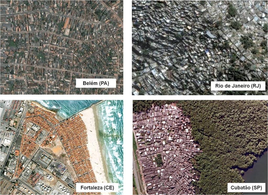
12 TERRITORIAL TIPOLOGIES Slum Areas They are zones of special social interest with important demand for statistical information. It is necessary to stablish geographic criteria to identify its limits and allow its association to statistical data Belo Horizonte (MG)

13 TERRITORIAL TIPOLOGIES Slum Areas Rio de Janeiro (RJ)

")
14 TERRITORIAL TIPOLOGIES Slum Areas Manaus (AM)

15 TERRITORIAL TIPOLOGIES Slum Areas Belo Horizonte (MG)
16 TERRITORIAL TIPOLOGIES


17 REGIONAL DIVISIONS Geographical units formed by the grouping of municipalities, encompassing a synthetic regional setting or a specific criteria setting, such as those based on urban system or predominant rural activitiy Mesorregiões Divisão urbano regional Semiárido e regiões metropolitanas

18 REGIONAL DIVISIONS Urban Concentrations In a national scale urban perspective, IBGE sets criteria for the identification of urban concentrations, allowing statistical information analysis in varied contexts and geographic scales. Urban concentration in Belo Horizonte

19 REGIONAL DIVISIONS Urban Concentrations Aglomeração urbana Para uma visão de todo o território nacional sob uma mesma perspectiva da temática urbana, o IBGE estabelece critérios operacionais para a identificação de aglomerações, considerando o conceito de agregados de municípios, o que permite a análise das informações estatísticas em diversos contextos e escalas geográficas. Exemplos de divisões regionais (fotos, imagens, mapas) Para a compreensão dos espaços urbanos, por exemplo no que diz respeito ao planejamento de transportes e avaliação de mercado, é necessário ter a ideia de todo o espaço urbanao e naão somente a unidade politicia.


20 RECORD AND DISSEMINATION UNITS OF CENSUS AND SAMPLES The structure of IBGE's recording for household surveys includes georeferencing by the sides of urban block adresses and point geographic coordinates in the rural enumeration areas. They both form the National Register of Adresses for Statistical Purposes. Satellite imagery Orthoimages Field Surveys

21 RECORD AND DISSEMINATION UNITS OF CENSUS AND SAMPLES The basic spatial feature in the household surveys is the enumeration areas, the territorial unity for verifying and disseminating the statistical datasets Census tracts
22 RECORD AND DISSEMINATION UNITS OF CENSUS AND SAMPLES Side of urban block enumeration areas


23 RECORD AND DISSEMINATION UNITS OF CENSUS AND SAMPLES There are on demand custom features of territorial delimitations accounting for a more flexible statistical dissemination than the simple enumeration areas aggregation Example: demographic census data aggregation for natural disasters susceptible areas

24 RECORD AND DISSEMINATION UNITS OF CENSUS AND SAMPLES Example: use of urban block sides for the creation of a new territorial delimitation to link to demographic census data BATER Área de risco Face de quadra Setor Censitário
 Dissemination the integrated geospatial-statistical information through a Spatial data Infrastructure")
25 IBGE PRODUCTION AND GEOGRAPHIC INFORMATION DISSEMINATION POLICY TO Grant public and free access to geospatial and statistical databases; Dissemination of the databases of all created maps; Statistical and geospatial metadata integration based on Spatial data Infrastructure (SDI) Dissemination the integrated geospatial-statistical information through a Spatial data Infrastructure standards web services
26 IBGE PRODUCTION AND DISSEMINATION POLICY TO GEOGRAPHIC INFORMATION Since 2013 all geographical products released by IBGE are conform to INDE's standards and they are disseminated as location-based databases. Example: Atlas of Demographic Census 2010
27 DATA AND METADATA INTEGRATION The summarized MGB profile is used to the thematic information, which is conformed to the ISO normatization. The file comprises: Title Reference date Summary Statistical metadata Geospatial metadata


28 DATA AND METADATA INTEGRATION The spatial metadata SUMMARY field allows the linking of statistical e geospatial metadata as a first step of the integration process. This field has the following features: full name of the variable/indicator: name with exact description, following the research documentation calculation formulas notes: existing comments on the published map that are relevant to the understanding of the variable/indicator explanation of the terms: includes all definitions of all variables used in the mapped theme data source


29 DATA AND METADATA INTEGRATION Map containing the median age at first marriage of the total population, of the Summary field male population, of the female population and the difference between the mean age of the male and female married, by municipality. The median age at first marriage was calculated for persons aged 15 years or older, based on the technical named Singulate Mean Age at Marriage SMAM, developed by Hajnal (1953)

30 FUTURE PERSPECTIVES IN IBGE To continue with the policy of releasing all geospatial data as a geospatial data service attached to NSDI Integration of the IBGE Automatic Retrieval System (SIDRA) to the production of geospatial data service according to the SDI standards To improve the integration between statistical metadata and geospatial metadata. To develop new territorial delimitations for statistical census and sample surveys dissemination, e.g. watershed limits To develop grids for statistical dissemination. Challenge: the creation of a international standard of a integrated statistical and geospatial metadata

31 Thank you!
Integration of geographical and statistical information: The Brazilian case 1
 UNITED NATIONS SECRETARIAT SA/STAT/AC.279/P16 Department of Economic and Social Affairs October 2013 Statistics Division English only United Nations Expert Group on the Integration of Statistical and Geospatial
Brazil Experience in SDG data production, dissemination and capacity building
 Brazil Experience in SDG data production, dissemination and capacity building Claudio Stenner Coordinator of Geography 4th Meeting of the Working Group on Geospatial Information IAEG-SDG United Nations
Mapping Brazil in 1:250,000 scale. João Bosco de Azevedo
 Mapping Brazil in 1:250,000 scale João Bosco de Azevedo Belo Horizonte, outubro de 2005 Brazil in figures The Brazilian territory attracts attention because of its area, the fifth largest area of the world.
Brazil Paper for the. Second Preparatory Meeting of the Proposed United Nations Committee of Experts on Global Geographic Information Management
 Brazil Paper for the Second Preparatory Meeting of the Proposed United Nations Committee of Experts on Global Geographic Information Management on Data Integration Introduction The quick development of
BRAZILIAN EXPERIENCE IN USE OF GEORREFERENCING AND REMOTE SENSING IN CENSUS. Brazilian Institute of Geography and Statistics IBGE
 BRAZILIAN EXPERIENCE IN USE OF GEORREFERENCING AND REMOTE SENSING IN CENSUS Brazilian Institute of Geography and Statistics IBGE www.ibge.gov.br 1- INTRODUCTION This paper presents the brazilian experience
Common geographies for dissemination of SDG Indicators
 5 th High Level Forum on United Nations GGIM, Mexico 2017 Common geographies for dissemination of SDG Indicators Understanding statistical and geodetic division of territory Janusz Dygaszewicz Central
ENVIRONMENTAL VULNERABILITY INDICATORS OF THE COASTAL SLOPES OF SÃO PAULO, BRAZIL *
 ENVIRONMENTAL VULNERABILITY INDICATORS OF THE COASTAL SLOPES OF SÃO PAULO, BRAZIL * D ANTONA, Álvaro de O. (FCA, NEPO-Unicamp, Brazil) BUENO, Maria do Carmo D. (IBGE; IFCH-Unicamp, Brazil) IWAMA, Allan
Challenges in Geospatial Policy Formulation and Programme Management
 Challenges in Geospatial Policy Formulation and Programme Management Luiz Paulo Souto Fortes, PhD An Exchange with the Geospatial Industry for UN-GGIM Seoul, October 23, 2011 BRAZIL Land area 8,514,876.599
Merging statistics and geospatial information
 Merging statistics and geospatial information Demography / Commuting / Spatial planning / Registers Mirosław Migacz Chief GIS Specialist Janusz Dygaszewicz Director Central Statistical Office of Poland
Small Area Housing Deficit Estimation: A Spatial Microsimulation Approach
 Small Area Housing Deficit Estimation: A Spatial Microsimulation Approach Flávia da Fonseca Feitosa 1, Roberta Guerra Rosemback 2, Thiago Correa Jacovine 1 1 Centro de Engenharia, Modelagem e Ciências
Statistical analysis of geospatial information and relevance of SDI s Standards. The Brazilian case
 Statistical analysis f gespatial infrmatin and relevance f SDI s Standards Statit The Brazilian case Claudi Stenner Crdinatr f Gegraphy Brazilian Institute f Gegraphy and Statistics - IBGE Internatinal
Policies towards SDI development and implementation in the Americas
 Policies towards SDI development and implementation in the Americas Valéria Oliveira Henrique de Araújo Executive Secretary of CP-IDEA Brazilian Institute of Geography and Statistics - IBGE Geospatial
1 ST High Level Forum on United Nations Global Geoespatial Information Management GEOGRAPHIC REFERENCING OF ECONOMIC UNITS. México
 1 ST High Level Forum on United Nations Global Geoespatial Information Management Thematic Seminar 27 October, Korea 2011. GEOGRAPHIC REFERENCING OF ECONOMIC UNITS México CONTENTS Introduction Census Cartography
Spatial index of educational opportunities: Rio de Janeiro and Belo Horizonte
 Available online at www.sciencedirect.com Procedia Social and Behavioral Sciences 21 (2011) 287 293 International Conference: Spatial Thinking and Geographic Information Sciences 2011 Spatial index of
Rules of the territorial division
 Rules of the territorial division Janusz Dygaszewicz Central Statistical Office of Poland Jerusalem, 4-7 December 2016 Rules of territory division (the Polish case) The area of each unit of territorial
Second High Level Forum on GGIM Seminar on Regional Cooperation in Geospatial Information Management Doha, Qatar, 7 February 2013
 Second High Level Forum on GGIM Seminar on Regional Cooperation in Geospatial Information Management Doha, Qatar, 7 February 2013 Overview on Geospatial Activities in Egypt BY : Eng.Nahla Seddik Mohamed
Geospatial Enabling Resilient Development. Latin America Geospatial Forum Río de Janeiro September 2013
 Geospatial Enabling Resilient Development Latin America Geospatial Forum Río de Janeiro September 2013 Presentation Index INEGI /SNIEG Geostatistical Frame - Georeferenciation Issues Legal Framework Mexican
Final report for the Expert Group on the Integration of Statistical and Geospatial Information, May 2015
 Final report for the Expert Group on the Integration of Statistical and Geospatial Information, May 2015 Global geographic classification and geocoding practices Executive summary This final report was
GIS FOR MAZOWSZE REGION - GENERAL OUTLINE
 GIS FOR MAZOWSZE REGION - GENERAL OUTLINE S. Bialousz 1), K Mączewski 2), E. Janczar 2), K. Osinska-Skotak 1) 1) Warsaw University of Technology, Warsaw, Poland 2) Office of the Surveyor of the Mazowieckie
Disaster Management in Mongolia
 The Third UN-GGIM-AP Plenary Meeting Disaster Management in Mongolia ~Coordination among NGIA & Other Related Organizations and Recommendations~ Bali Indonesia 10 November 2014 Khurelshagai Ayurzana, Director
Country Report of Brazil United Nations Committee of Experts on Global Geospatial Information Management (UN-GGIM)
") Directorade of Geociencies Country Report of Brazil United Nations Committee of Experts on Global Geospatial Information Management (UN-GGIM) Fourth session New York, August 6-8, 2014 Country Report of
Directorade of Geociencies Country Report of Brazil United Nations Committee of Experts on Global Geospatial Information Management (UN-GGIM) Fourth session New York, August 6-8, 2014 Country Report of
Key Elements of the Geographical Information System of Mexico *
 UNITED NATIONS E/CONF.99/IP.1 ECONOMIC AND SOCIAL COUNCIL Ninth United Nations Regional Cartographic Conference for the Americas New York, 10-14 August 2009 Item 7(a) of the provisional agenda Strategy,
Development Of Common Frameworks And Methodologies *
 HIGH LEVEL FORUM ON GLOBAL GEOSPATIAL MANAGEMENT INFORMATION WORKING PAPER No. 9 First Forum Seoul, Republic of Korea, 24-26 October 2011 Development Of Common Frameworks And Methodologies * * Submitted
Principle 3: Common geographies for dissemination of statistics Poland & Canada. Janusz Dygaszewicz Statistics Poland
 Principle 3: Common geographies for dissemination of statistics Poland & Canada Janusz Dygaszewicz Statistics Poland Reference materials Primary: Ortophotomap, Cadastral Data, Administrative division borders,
Set-up of subnational statistical systems Statistical Development Strategy for the State of Jalisco México, 2016
 Set-up of subnational statistical systems Statistical Development Strategy for the State of Jalisco México, 2016 Statistical and Geographical Information Institute of Jalisco (IIEG) 2013. Merger of three
INSPIRE and Land Use Planning System in Portugal
 INSPIRE and Land Use Planning System in Portugal Rui Amaro Alves Director General Directorate General for Territorial Development ruialves@dgterritorio.pt Carlos Simões Senior Technician Directorate General
Compact guides GISCO. Geographic information system of the Commission
 Compact guides GISCO Geographic information system of the Commission What is GISCO? GISCO, the Geographic Information System of the COmmission, is a permanent service of Eurostat that fulfils the requirements
Brazilian National Spatial Data Infrastructure (INDE): Applicability for Large Scale Data
: Applicability for Large Scale Data") Brazilian National Spatial Data Infrastructure (INDE): Applicability for Large Scale Data Andrea Lopes Iescheck*, Marco Aurélio Dorneles** * Federal University of Rio Grande do Sul UFRGS, Institute of
Brazilian National Spatial Data Infrastructure (INDE): Applicability for Large Scale Data Andrea Lopes Iescheck*, Marco Aurélio Dorneles** * Federal University of Rio Grande do Sul UFRGS, Institute of
GEOMARKETING AND GEOGRAPHIC INFORMATION SYSTEMS FOR URBAN DECISIONS: INDICATION OF THE BEST LOCATION FOR A CONVENTION CENTER IN BELO HORIZONTE MG.
 GEOMARKETING AND GEOGRAPHIC INFORMATION SYSTEMS FOR URBAN DECISIONS: INDICATION OF THE BEST LOCATION FOR A CONVENTION CENTER IN BELO HORIZONTE MG. Renata Hungari. Universidade Federal de Minas Gerais.
Department of Economic and Social Affairs May 2007
 UNITED NATIONS SECRETARIAT ESA/STAT/AC.115/13 Department of Economic and Social Affairs May 2007 Statistics Division English only United Nations Expert Group Meeting on Contemporary Practices in Census
SDI Development in the Russian Federation
 , the Russian Federation Key words: SDI development, the Russian Federation SUMMARY A reform in the field of spatial data is gathering headway in Russia. Creation of a single agency, which united state
Achieving the Vision Geo-statistical integration addressing South Africa s Developmental Agenda. geospatial + statistics. The Data Revolution
 Achieving the Vision Geo-statistical integration addressing South Africa s Developmental Agenda geospatial + statistics The Data Revolution humble beginnings, present & future - South Africa UN World Data
Concept Formulation of Geospatial Infrastructure. Hidenori FUJIMURA*
 Concept Formulation of Geospatial Infrastructure 1 Concept Formulation of Geospatial Infrastructure Hidenori FUJIMURA* (Published online: 28 December 2016) Abstract Technical trends in the field of surveying
Creating synergies between Statistical and Geospatial information for better policy outputs: The case of Mexico
 Creating synergies between Statistical and Geospatial information for better policy outputs: The case of Mexico Geospatial & Statistics Integration for Informed Decision Making Geospatial World Forum 2017
Integrating Official Statistics and Geospatial Information NBS Experience
 Integrating Official Statistics and Geospatial Information NBS Experience Presented by Eng. Reda AL Sabbagh Director of IT Dept. Prepared by Eng. Adham Makky GIS Specialist Topics to be covered: Background
Understanding China Census Data with GIS By Shuming Bao and Susan Haynie China Data Center, University of Michigan
 Understanding China Census Data with GIS By Shuming Bao and Susan Haynie China Data Center, University of Michigan The Census data for China provides comprehensive demographic and business information
Census Geography, Geographic Standards, and Geographic Information
 Census Geography, Geographic Standards, and Geographic Information Michael Ratcliffe Geography Division US Census Bureau New Mexico State Data Center Data Users Conference November 19, 2015 Today s Presentation
Combining Geospatial and Statistical Data for Analysis & Dissemination
 Combining Geospatial and Statistical Data for Analysis & Dissemination (with Special Reference to Qatar Census 2010) Presentation by Mansoor Al Malki, Director of IT Department Qatar Statistics Authority
São Paulo Metropolis and Macrometropolis - territories and dynamics of a recent urban transition
 São Paulo Metropolis and Macrometropolis - territories and dynamics of a recent urban transition Faculty of Architecture and Urbanism of São Paulo University Prof. Dr. Regina M. Prosperi Meyer WC2 - World
SDI Development in Georgia. Mari Khardziani Head of International Relations Unit National Agency of Public Registry
 SDI Development in Georgia Mari Khardziani Head of International Relations Unit National Agency of Public Registry Kehl, Germany September 5, 2017 2 National Agency of Public Registry Legal Entity of Public
An Introduction to China and US Map Library. Shuming Bao Spatial Data Center & China Data Center University of Michigan
 An Introduction to China and US Map Library Shuming Bao Spatial Data Center & China Data Center University of Michigan Current Spatial Data Services http://chinadataonline.org China Geo-Explorer http://chinageoexplorer.org
UN GGIM and National SDI Strategy
 MSDI Open Forum on 26 th January 2016 Contributing to the successful delivery of MSDI UN GGIM and National SDI Strategy Hiroshi Murakami Deputy Administrator Geospatial Information Authority of Japan Geospatial
Use of administrative registers for strengthening the geostatistical framework of the Census of Agriculture in Mexico
 Use of administrative registers for strengthening the geostatistical framework of the Census of Agriculture in Mexico Susana Pérez INEGI, Dirección de Censos y Encuestas Agropecuarias. Avenida José María
GEOMATICS. Shaping our world. A company of
 GEOMATICS Shaping our world A company of OUR EXPERTISE Geomatics Geomatics plays a mayor role in hydropower, land and water resources, urban development, transport & mobility, renewable energy, and infrastructure
National Spatial Data Infrastructure International workshop 9 th June, 2015 Terelj Hotel, Mongolia
 1 st session: NSDI policy, planning and the legal framework Formation of NSDI policy and legal framework in Mongolia Khurelshagai Ayurzana, Director General, Administration of Land Affairs, Geodesy and
USE OF SATELLITE IMAGES FOR AGRICULTURAL STATISTICS
 USE OF SATELLITE IMAGES FOR AGRICULTURAL STATISTICS National Administrative Department of Statistics DANE Colombia Geostatistical Department September 2014 Colombian land and maritime borders COLOMBIAN
GRID map of Household and Population data in Kosovo. European Forum for Geostatistics, 5 7 October 2009, in The Hague, Netherlands
 GRID map of Household and Population data in Kosovo European Forum for Geostatistics, 5 7 October 2009, in The Hague, Netherlands SUMMARY Introduction Data sources Methods Results, & Maps WebGIS Description
Geographic Boundaries of Population Census of Japan 1
 UNITED NATIONS SECRETARIAT ESA/STAT/AC.279/P20 Department of Economic and Social Affairs October 2013 Statistics Division English only United Nations Expert Group on the Integration of Statistical and
GEOGRAPHIC INFORMATION SYSTEMS Session 8
 GEOGRAPHIC INFORMATION SYSTEMS Session 8 Introduction Geography underpins all activities associated with a census Census geography is essential to plan and manage fieldwork as well as to report results
Norwegian spatial data infrastructure supporting disaster risk management Norwegian Mapping Authority
 Norwegian spatial data infrastructure supporting disaster risk management Norwegian Mapping Authority Arvid Lillethun, Norwegian Mapping Authority Land and Poverty 2018 Conference, World Bank 19.-23. March
Improving rural statistics. Defining rural territories and key indicators of rural development
 Improving rural statistics Defining rural territories and key indicators of rural development Improving rural statistics Improving Rural Statistics In 2016, the Global Strategy to improve Agricultural
CES Seminar 2016: Geospatial information services based on official statistics Key issues from the session II papers
 Norbert Rainer 64 th plenary session of the Conference of European Statisticians 28 April 2016, Paris CES Seminar 2016: Geospatial information services based on official statistics Key issues from the
Technical Documentation Demostats april 2018
 Technical Documentation Demostats 2018 april 2018 what it is DemoStats is a database of estimates and projections for a comprehensive set of demographic and socioeconomic attributes about the Canadian
A proposal for building an infrastructure for European geospatial statistics. Marie Haldorson, Statistics Sweden Ekkehard Petri, Eurostat
 A proposal for building an infrastructure for European geospatial statistics Marie Haldorson, Statistics Sweden Ekkehard Petri, Eurostat What is geospatial statistics? The location, extent or spatial relations
Funding systems used in Mexico to support institutional arrangements: INEGI case
 Funding systems used in Mexico to support institutional arrangements: INEGI case Sistemas de financiamiento usados en México, para soportar arreglos institucionales: Caso INEGI United Nations Committee
Funding models for institutional arrangements in the context of a national SDI: the case of Chile
 Funding models for institutional arrangements in the context of a national SDI: the case of Chile Alvaro Monett Hernández Executive Secretary SNIT Chile Vice-President UN-GGIM Américas Fifth Meeting of
Operational Definitions of Urban, Rural and Urban Agglomeration for Monitoring Human Settlements
 Operational Definitions of Urban, Rural and Urban Agglomeration for Monitoring Human Settlements By Markandey Rai United Nations Human Settlements Programme PO Box-30030 Nairobi, Kenya Abstract The United
Project based approach developing National Spatial Data Infrastructure in Lithuania
 Project based approach developing National Spatial Data Infrastructure in Lithuania National Land Service under the Ministry of Agriculture of The Republic of Lithuania Cadastres & Geodesy Department Director
CARTOGRAPHIC INFORMATION MANAGEMENT IN COLOMBIA REACH A LEVEL OF PERFECTION
 CARTOGRAPHIC INFORMATION MANAGEMENT IN COLOMBIA REACH A LEVEL OF PERFECTION Jaime Alberto Duarte Castro 1 Carrera 30 No. 48 51 Bogotá - Colombia, jduarte@igac.gov.co Claudia Inés Sepúlveda Fajardo 2 Carrera
Gistat: moving towards a location information management system
 Gistat: moving towards a location information management system (merging geographical, statistical and historical information) Pina Grazia Ticca Marco Ballin Istat - Italy Aguascalientes, Mexico 2-4 December
A proposal for building an infrastructure for European geospatial statistics
 A proposal for building an infrastructure for European geospatial statistics Marie Haldorson, Statistics Sweden Ekkehard Petri, Eurostat What is geospatial statistics? The location, extent or spatial relations
Land Administration and Cadastre
 Geomatics play a major role in hydropower, land and water resources and other infrastructure projects. Lahmeyer International s (LI) worldwide projects require a wide range of approaches to the integration
SITMUN: Cooperating to Build Local SDIs in the Barcelona Region
 SITMUN: Cooperating to Build Local SDIs in the Barcelona Region Diputació de Barcelona Territory and Sustainability Area Territorial Information Systems Department INSPIRE CONFERENCE Barcelona, September
European Regional and Urban Statistics
 European Regional and Urban Statistics Dr. Berthold Feldmann berthold.feldmann@ec.europa.eu Eurostat Structure of the talk Regional statistics in the EU The tasks of Eurostat Regional statistics Urban
Integration of Geo spatial and Statistical Information: The Nepelese Experience
 Integration of Geo spatial and Statistical Information: The Nepelese Experience Krishna Raj B.C. Joint Secretary Ministry of Land Reform and Management, Nepal 11 June, 2014 Presentation Outline The Country
Egyptian E-Census 2017
 Egyptian E-Census 2017 Central Agency for Public Mobilization And Statistics An Integration between Spatial and Statistical information Prepared by: Nahla Seddik Mohamed General Director Mennat-Allah Anwar
Welcome. C o n n e c t i n g
 Welcome C o n n e c t i n g YOU D i s c i p l i n e s Why is This Meeting......So Important Now? OUR WORLD Is Increasingly Challenged The Evidence Is Clear We Need Better Understanding and More Collaboration
Measuring Disaster Risk for Urban areas in Asia-Pacific
 Measuring Disaster Risk for Urban areas in Asia-Pacific Acknowledgement: Trevor Clifford, Intl Consultant 1 SDG 11 Make cities and human settlements inclusive, safe, resilient and sustainable 11.1: By
Sharthi Laldaparsad Statistics South Africa, Policy Research & Analysis. Sub-regional workshop on integration of administrative data,
 Sub-regional workshop on integration of administrative data, big data and geospatial information for the compilation of SDG indicators and International Workshop on Global Fundamental Geospatial Data Themes
Spatial Organization of Data and Data Extraction from Maptitude
 Spatial Organization of Data and Data Extraction from Maptitude N. P. Taliceo Geospatial Information Sciences The University of Texas at Dallas UT Dallas GIS Workshop Richardson, TX March 30 31, 2018 1/
COLLABORATIVE GI BASED APPROACH: Discussing GI relevance towards monitoring EU Legal Framework. Maria José VALE Raquel SARAIVA Rui REIS
 COLLABORATIVE GI BASED APPROACH: Discussing GI relevance towards monitoring EU Legal Framework Maria José VALE Raquel SARAIVA Rui REIS Summary INSPIRE directive and Spatial Data Infrastructure Data availability
Standards in Action: The Canadian Geospatial Data Infrastructure (CGDI)
") Standards in Action: The Canadian Geospatial Data Infrastructure (CGDI) Craig Stewart ISO/TC211 Standards in Action Workshop, September 14, 2005 Presentation Outline Overview of SDIs Overview of Canada
Standards in Action: The Canadian Geospatial Data Infrastructure (CGDI) Craig Stewart ISO/TC211 Standards in Action Workshop, September 14, 2005 Presentation Outline Overview of SDIs Overview of Canada
Integration for Informed Decision Making
 Geospatial and Statistics Policy Intervention: Integration for Informed Decision Making Greg Scott Global Geospatial Information Management United Nations Statistics Division Department of Economic and
THE SPATIAL DATA WAREHOUSE OF SEOUL
 THE SPATIAL DATA WAREHOUSE OF SEOUL Jae-Ho Han The Seoul Metropolitan Government Seoul City Hall, Taepyeongno 1(il)-ga, Jung-gu, Seoul 100-744, Korea djhjha@hanmail.net Impyeong Lee Dept. of Geoinformatics,
Statistical-geospatial integration - The example of Sweden. Marie Haldorson Director, Statistics Sweden
 Statistical-geospatial integration - The example of Sweden Marie Haldorson Director, Statistics Sweden Spatial data and geospatial applications at Statistics Sweden Long tradition GI integrated in production
Pal NIKOLLI Bashkim IDRIZI Ismail KABASHI Adelajda HALILI THE IMPLEMENTATION OF NATIONAL SPATIAL DATA INFRASTRUCTURE IN ALBANIA
 Pal NIKOLLI Bashkim IDRIZI Ismail KABASHI Adelajda HALILI THE IMPLEMENTATION OF NATIONAL SPATIAL DATA INFRASTRUCTURE IN ALBANIA Overview: Goals of paper Some definitions of SDI NSDI Development NSDI in
Second Administrative Level Boundaries (SALB) initiative & geographic names in cartography. Geospatial Information Section
 initiative & geographic names in cartography. Geospatial Information Section") Second Administrative Level Boundaries (SALB) initiative & geographic names in cartography Geospatial Information Section Introduction Goals Global agenda How does SALB work? Latest News on geographic
Second Administrative Level Boundaries (SALB) initiative & geographic names in cartography Geospatial Information Section Introduction Goals Global agenda How does SALB work? Latest News on geographic
INSPIRE implementation in the Turkish Ministry of Environment and Urbanization Producing and Publishing Environmental Data
 INSPIRE implementation in the Turkish Ministry of Environment and Urbanization Producing and Publishing Environmental Data Ezgi Sarmusak Urban Planner, MoEU Sibel Süer Toybıyık - Assistant Expert, MoEU
Globally Estimating the Population Characteristics of Small Geographic Areas. Tom Fitzwater
 Globally Estimating the Population Characteristics of Small Geographic Areas Tom Fitzwater U.S. Census Bureau Population Division What we know 2 Where do people live? Difficult to measure and quantify.
ECONOMIC AND SOCIAL COUNCIL 13 July 2007
 UNITED NATIONS E/CONF.98/CRP.34 ECONOMIC AND SOCIAL COUNCIL 13 July 2007 Ninth United Nations Conference on the Standardization of Geographical Names New York, 21-30 August 2007 Item 17(b) of the provisional
Current Status of the Standardization of Geographical Names in Cambodia
 1 Current Status of the Standardization of Geographical Names in Cambodia His Excellency Ith Sotha, Under Secretary of States, MLMUPC Mr Chharom Chin, Deputy Director, Geography Department, MLMUPC Mr Narith
Country Report of Spain *
 Committee of Experts on Global Geospatial Information Management Second Session New York, United Nations (UN), 13 15 de August de 2012 Country Report of Spain * * Submitted by: Mr. Antonio Arozarena, Deputy
Presented to Sub-regional workshop on integration of administrative data, big data and geospatial information for the compilation of SDG indicators
 Presented to Sub-regional workshop on integration of administrative data, big data and geospatial information for the compilation of SDG indicators 23-25 April,2018 Addis Ababa, Ethiopia By: Deogratius
GROUP ON INTEGRATION OF STATISTICAL AND GEOSPATIAL INFORMATION GT-IIEG
 UN-GGIM: Americas WORKING GROUP ON INTEGRATION OF STATISTICAL AND GEOSPATIAL INFORMATION GT-IIEG Bogotá, Colombia August, 2018 www.dane.gov.co Working group GT-IIEG Objective: To raise awareness and promote
Some practices of Geospatial coding and referencing statistics in Finland and in Europe
 Some practices of Geospatial coding and referencing statistics in Finland and in Europe Marja Tammilehto-Luode UN Expert Group on the Integration of Statistical and Geospatial Information 30.10. 1.11.2013
SIRGAS: Basis for Geosciences, Geodata, and Navigation in Latin America
 SIRGAS: Basis for Geosciences, Geodata, and Navigation in Latin America Claudio Brunini President of SIRGAS Universidad Nacional de La Plata, Argentina María Virginia Mackern President of SIRGAS/WG-I:
STATE GEOGRAPHIC INFORMATION DATABASE
 STATE GEOGRAPHIC INFORMATION DATABASE Data Information and Knowledge Management STATE GEOGRAPHIC INFORMATION DATABASE EXECUTIVE SUMMARY Utah has developed one of the most comprehensive statewide GIS resources
Qatar Statistical Geospatial Integration
 Qatar Statistical Geospatial Integration A Presentation by the Ministry of Development Planning & Statistics (MDPS), State of Qatar http://www.mdps.gov.qa (Fourth UN-GGIM Arab States Committee Meeting,
Developing an Organizational Geospatial Data Framework: A Case Study of Kenya National Bureau of Statistics
 Developing an Organizational Geospatial Data Framework: A Case Study of Kenya National Bureau of Statistics Hellen Wanyoike 1, David Kuria 2 Institute of Geomatics, GIS & Remote Sensing, Dedan Kimathi
GI AND WATERSHED MANAGEMENT: Discussing GI relevance Towards monitoring EU Legal Framework
 DGT- Direcção Geral do Território GI AND WATERSHED MANAGEMENT: Discussing GI relevance Towards monitoring EU Legal Framework Maria José Vale and Raquel Saraiva INSPIRE CONFERENCE 2012 ISTAMBUL Summary
KENYA NATIONAL BUREAU OF STATISTICS Workshop on
 KENYA NATIONAL BUREAU OF STATISTICS Workshop on Capacity Building in Environment Statistics: the Framework for the Development of Environment Statistics (FDES 2013) Coordination with Sector Ministries
GIS Building Communities beyond National Borders (Building Successful Spatial Data Infrastructures) Nick Land, ESRI Europe
 Nick Land, ESRI Europe") GIS Building Communities beyond National Borders (Building Successful Spatial Data Infrastructures) Nick Land, ESRI Europe UK worst flooding in the last 60 years 350,000 households without drinking water
GIS Building Communities beyond National Borders (Building Successful Spatial Data Infrastructures) Nick Land, ESRI Europe UK worst flooding in the last 60 years 350,000 households without drinking water
ADMINISTRATION OF GEOGRAPHICAL NAMES IN URUGUAY
 ADMINISTRATION OF GEOGRAPHICAL NAMES IN URUGUAY 1st. Lt. Julio C. Teixeira Executive Officer Geodesy & Topography Division Military Geographic Service Av. 8 de Octubre 3255. Montevideo, URUGUAY Telph.:
Frontier and Remote (FAR) Area Codes: A Preliminary View of Upcoming Changes John Cromartie Economic Research Service, USDA
 Area Codes: A Preliminary View of Upcoming Changes John Cromartie Economic Research Service, USDA") National Center for Frontier Communities webinar, January 27, 2015 Frontier and Remote (FAR) Area Codes: A Preliminary View of Upcoming Changes John Cromartie Economic Research Service, USDA The views
National Center for Frontier Communities webinar, January 27, 2015 Frontier and Remote (FAR) Area Codes: A Preliminary View of Upcoming Changes John Cromartie Economic Research Service, USDA The views
Foundation Geospatial Information to serve National and Global Priorities
 Foundation Geospatial Information to serve National and Global Priorities Greg Scott Inter-Regional Advisor Global Geospatial Information Management United Nations Statistics Division UN-GGIM: A global
A PROPOSAL OF REGULATORY STANDARDS FOR CADASTRAL MAPPING IN BRAZIL
 Abstract A PROPOSAL OF REGULATORY STANDARDS FOR CADASTRAL MAPPING IN BRAZIL Valéria Oliveira Henrique de Araújo Brazilian Institute for Geography and Statistics IBGE valeria.araujo@ibge.gov.br Cadastral
Creating A-16 Compliant National Data Theme for Cultural Resources
 Creating A-16 Compliant National Data Theme for Cultural Resources Cultural Resource GIS Facility National Park Service John J. Knoerl Deidre McCarthy Paper 169 Abstract OMB Circular A-16 defines a set
The Integrated Ge spatial Information Framework to the strengthening of NSDI, Mongolia
 Young Geospatial Professionals Summit 21 NOV 2018 The Integrated Ge spatial Information Framework to the strengthening of NSDI, Mongolia BAYARMAA ENKHTUR Geospatial information and technology department
GMES Service for Geospatial Reference Data Access (RDA) Covering Areas Outside Europe
 Covering Areas Outside Europe") INSPIRE Conference 2011 Edinburgh 27 June - 1 July GMES Service for Geospatial Reference Data Access (RDA) Covering Areas Outside Europe Andrea Ajmar, Simone Balbo, Piero Boccardo, Simone Dalmasso, Anna
INSPIRE Conference 2011 Edinburgh 27 June - 1 July GMES Service for Geospatial Reference Data Access (RDA) Covering Areas Outside Europe Andrea Ajmar, Simone Balbo, Piero Boccardo, Simone Dalmasso, Anna
Lessons Learned from the production of Gridded Population of the World Version 4 (GPW4) Columbia University, CIESIN, USA EFGS October 2014
 Columbia University, CIESIN, USA EFGS October 2014") Lessons Learned from the production of Gridded Population of the World Version 4 (GPW4) Columbia University, CIESIN, USA EFGS October 2014 Gridded Population of the World Gridded (raster) data product
Lessons Learned from the production of Gridded Population of the World Version 4 (GPW4) Columbia University, CIESIN, USA EFGS October 2014 Gridded Population of the World Gridded (raster) data product