Geographic Information System (GIS) approach in MSF
|
|
|
- Prudence Poole
- 5 years ago
- Views:
Transcription

")
1 Gegraphic Infrmatin System (GIS) apprach in MSF

2 MSF as rganizatin Funded in Paris in 1971 An internatinal, independent, medical humanitarian rganizatin Emergency aid t peple affected by armed cnflict, epidemics, natural disasters and exclusin frm healthcare Assistance t peple based n need, irrespective f race, religin, gender r plitical affiliatin 2015 Prjects in arund 70 cuntries 5 Operatinal centres, 24 assciatins, MSF Internatinal


3 Needs n the grund Infrmatin n Ppulatin numbers Settlements (numbers, types.) Infrastructure (health facilities, markets, water surces.) Distance (water, health facilities ) Tpgraphy, drainage patterns Access land/air Epidemilgy (disease patterns,.) Land use Brigitte Rsstti Michael Gldfarb
4 Cuntry MSF GIS unit Cuntry Cell MAP CENTRE Cuntry Cuntry Cuntry Cuntry Express needs and primary request data, Maps and tls Lcally prduced /cllected data Cell Cell Issue and validate requests data, Maps and tls Submit Datasets OC GIS fcal p. Issues and requests GIS UNIT Imprve, ppulate, develp tls GIS Experts Rush mde request Until 2015: 32 GIS specialists deplyed t prjects


5 Hw are we rganized Request Frm AOI Field Data (If any) Frnt Office Back Office Vienna Cell OCG GIS UNIT OC GIS fcal p. Cell ther OC Other OC GIS fcal p. Mansn GIS Fcal pint training catch-up sessin, August 31 Septembre 1, 2016

6 Map Centre library f maps Centralized database allwing users t access reference maps and data. participative platfrm users request maps and tls users submit their wn mapping prductin and data

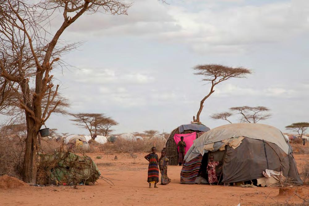
7 Field data On the grund GIS team in cuntry fr specific prject Teams in cuntry expl teams, regular prject teams, crdinatin. MSF data e.g. epi data HQ database, map centre.. D.Telemans


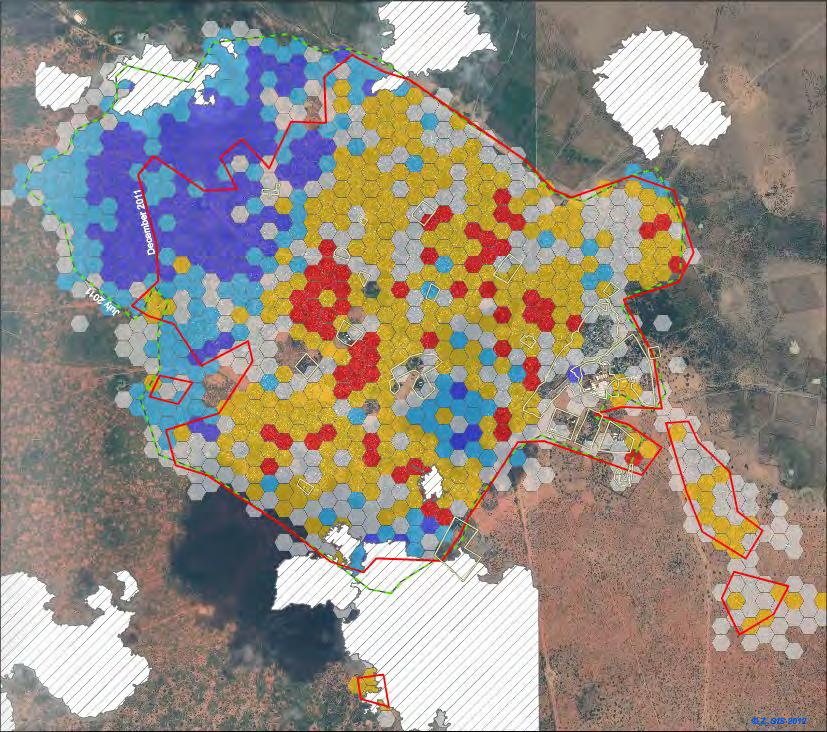
8 EO based data MSF Austria C-peratin with external partners tailr made tls, fitting MSFs peratinal needs Partners Z_GIS - Cperatin/ MOU since 2011 TU Wien (SATIDA) DLR (Buruli ulcer prject) Prjects EO4HumEn: Ppulatin mnitring tl, Grundwater, explratin tl, Envirnmental changes, funded by FFG SATIDA: Drught risk assessment Cnsrtium TU Wien,BOKU, ZAMG, IIASA, MSF. Funded by FFG Disseminatin via map centre


9 EO4HumEn - EO-based services t supprt humanitarian peratins Ppulatin cunt in camp setting Ppulatin cunt in urban setting Grundwater Vegetatin, land cver Natural disaster


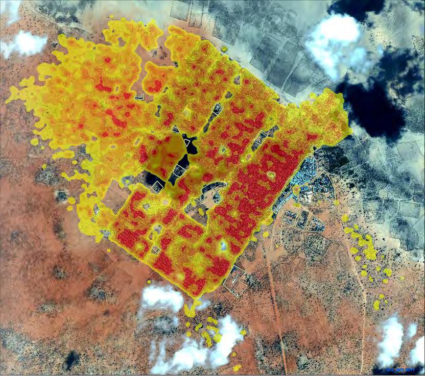
10 EO4HumEn - EO-based services t supprt humanitarian peratins


11 EO4HumEn - EO-based services t supprt humanitarian peratins Ppulatin cunt in rural settings Ppulatin cunt in urban settings Grundwater Vegetatin/ Land cver Natural disasters


12 EO4HumEn - EO-based services t supprt humanitarian peratins Ppulatin mnitring camp setting Ppulatin mnitring urban setting Grundwater Vegetatin/ Land cver Natural disasters


13 EO4HumEn - EO-based services t supprt humanitarian peratins Ppulatin mnitring camp setting Ppulatin mnitring urban setting Grundwater Vegetatin/ Land cver Natural disasters


14 Ppulatin mnitring in camp setting Ppulatin mnitring in urban setting Grundwater Vegetatin/ Land cver Natural disasters

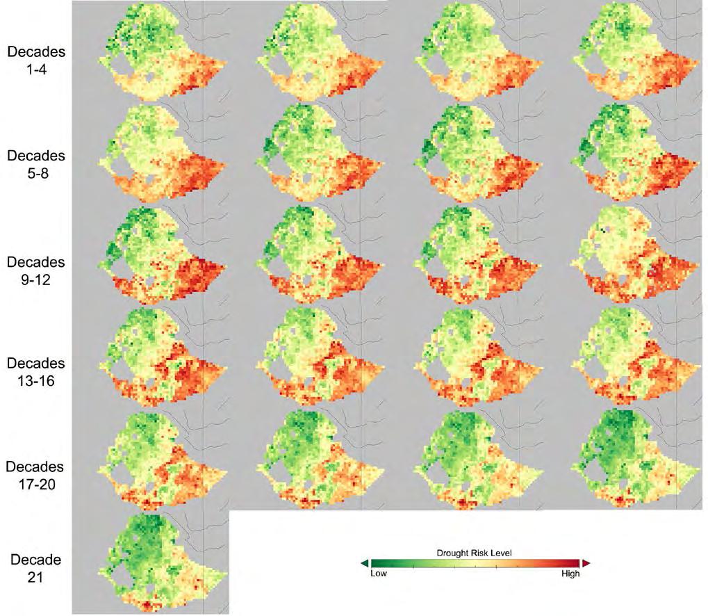


15 SATIDA (Satellite Technlgies fr imprved Drught-Risk assessment)


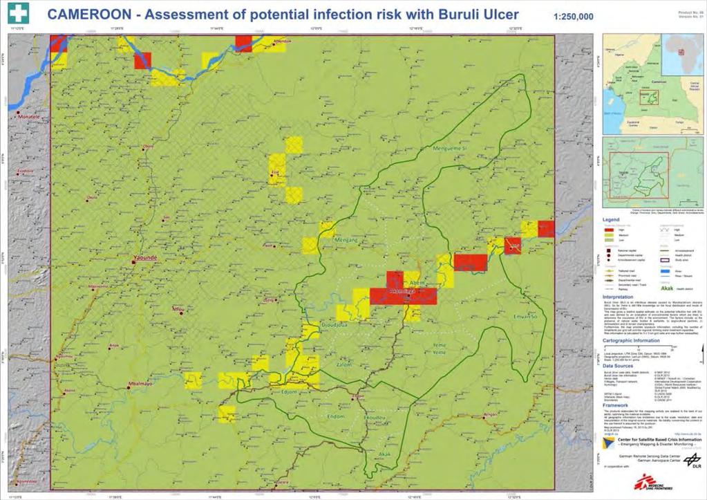
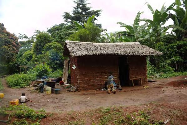
16 Buruli ulcer prject with DLR
17 MSF GIS unit Cuntry Cuntry Cell MAP CENTRE Cuntry Cuntry Cuntry Cuntry Express needs and primary request data, Maps and tls Lcally prduced /cllected data Cell Cell Issue and validate requests data, Maps and tls Submit Datasets OC GIS fcal p. Issues and requests GIS UNIT Imprve, ppulate, develp tls GIS Experts Rush mde request Until 2015: 32 GIS specialists deplyed t prjects
18 Phtcredits Needs n the grund: Brigitte Rsstti, Michael Gldfarb Mapman: Dieter Telemans Minkaman: David Di Lrenz Dagahaley: Brendan Bannn, T. Maruk Haiti/ Prt au Prince: Julie Remy Water tl: Francis Servranckx Landcver: Francesc Zizla/Nr, Serge Sibert/Csms Natural disaster: Luca Sla Buruli ulcer/ Aknlinga: Marcel Nimführ
The Belgian Virtual Tumourbank
 The Belgian Virtual Tumurbank In practice Céline Degaillier BVT Inauguratin sympsium 04/10/2012 Overview Frm thery t practice: A netwrk f cllabratins Belgian Cancer Plan and the virtual tumurbank Legal
Green economic transformation in Europe: territorial performance, potentials and implications
 ESPON Wrkshp: Green Ecnmy in Eurpean Regins? Green ecnmic transfrmatin in Eurpe: territrial perfrmance, ptentials and implicatins Rasmus Ole Rasmussen, NORDREGIO 29 September 2014, Brussels Green Grwth:
Land Information New Zealand Topographic Strategy DRAFT (for discussion)
") Land Infrmatin New Zealand Tpgraphic Strategy DRAFT (fr discussin) Natinal Tpgraphic Office Intrductin The Land Infrmatin New Zealand Tpgraphic Strategy will prvide directin fr the cllectin and maintenance
Land Infrmatin New Zealand Tpgraphic Strategy DRAFT (fr discussin) Natinal Tpgraphic Office Intrductin The Land Infrmatin New Zealand Tpgraphic Strategy will prvide directin fr the cllectin and maintenance
Models of Curriculum Development for Spatial Thinking across the College Curriculum USC
 Mdels f Curriculum Develpment fr Spatial Thinking acrss the Cllege Curriculum Spatial @ USC Jhn P. Wilsn Spatial Thinking acrss the Cllege Curriculum Specialist Meeting University f Califrnia at Santa
Statistical analysis of geospatial information and relevance of SDI s Standards. The Brazilian case
 Statistical analysis f gespatial infrmatin and relevance f SDI s Standards Statit The Brazilian case Claudi Stenner Crdinatr f Gegraphy Brazilian Institute f Gegraphy and Statistics - IBGE Internatinal
UBIMET. Climate Change Adaptation Strategies
 UBIMET Climate Change Adaptatin Strategies UBIMET INSTITUTE FOR UBIQUITOUS METEOROLOGY Internatinal Meterlgical Institute Funded in 2004 by a meterlgist and a chemist Glbal scpe / headquarters in Vienna,
LandScan Global Population Database
 LandScan Global Population Database The World s Finest Population Distribution Data Uncommon information. Extraordinary places. LandScan Global Population Database East View Cartographic is now offering
EO based monitoring of displaced population and natural resources for effective humanitarian operations
 INSPIRE Conference 2016 Barcelona, 26 th to 30 th September EO based monitoring of displaced population and natural resources for effective humanitarian operations Stefan Lang 1, Lorenz Wendt 1, Edith
GIS HELPDESK. GIS Campus Day 19/20. April 2018 Dr. Daniel Wyss
 GIS HELPDESK https://www.uni-gettingen.de/en/187111.html GIS Campus Day 19/20. April 2018 Dr. Daniel Wyss daniel.wyss@gettingen.de GIS Helpdesk 1 GIS HELPDESK Offered thrugh the Cartgraphy, GIS and RS
NWC SAF ENTERING A NEW PHASE
 NWC SAF ENTERING A NEW PHASE Pilar Fernández Agencia Estatal de Meterlgía (AEMET) Lenard Priet Castr, 8; 28040 Madrid, Spain Phne: +34 915 819 654, Fax: +34 915 819 767 E-mail: mafernandeza@aemet.es Abstract
Copernicus Overview. Major Emergency Management Conference Athlone 2017
 Copernicus Overview Major Emergency Management Conference Athlone 2017 Copernicus is a European programme implemented by the European Commission. The services address six thematic areas: land, marine,
Web-based GIS Systems for Radionuclides Monitoring. Dr. Todd Pierce Locus Technologies
 Web-based GIS Systems fr Radinuclides Mnitring Dr. Tdd Pierce Lcus Technlgies Lcus Technlgies 2014 Overview What is the prblem? Nuclear pwer plant peratrs need t mnitr radinuclides t safeguard the envirnment
Japanese HPCI Open Call
 SC-Asia 2018, SG-JP Jint sessin Japanese HPCI Open Call - HPCI : High Perfrmance Cmputing Infrastructure - Mti Okuda Research Organizatin fr Infrmatin Science & Technlgy What is HPCI? n Wrld tp class supercmputing
Chapter 1 Notes Using Geography Skills
 Chapter 1 Ntes Using Gegraphy Skills Sectin 1: Thinking Like a Gegrapher Gegraphy is used t interpret the past, understand the present, and plan fr the future. Gegraphy is the study f the Earth. It is
Facilitating landlocked and least developed country SMEs participation in trade
 Facilitating landlcked and least develped cuntry SMEs participatin in trade by the Hn. Mr. Ousavanh Thiengthepvngsa President f the Yung Entrepreneurs Assciatin f La PDR Email: usavanh@skcrpratin.cm Intrductin
EuroGEOSS Protected Areas Pilot
 EuroGEOSS Protected Areas Pilot Max Craglia European Commission Joint Research Centre Part 1: the present MyNatura2000 Mobile app. Awareness raising & volunteered data collection. Natura2000 covers 18%
Technical Committee Noise. Minutes of the 11 th Meeting
 Technical Cmmittee Nise within the Eurpean Acustics Assciatin EAA Minutes f the 11 th Meeting held n May 28 th, 2018, in Crete Time and Place The meeting was scheduled n May 28 th, 2018, frm 19:00 h t
MFC s recent development regarding presentation of high resolution weather information in Thick and Thin clients
 Nrwegian Meterlgical Institute - Marine Frecasting Centre MFC s recent develpment regarding presentatin f high reslutin weather infrmatin in Thick and Thin clients Bjørn Åge Hjøll Head f Sectin Nrwegian
Intelligent Pharma- Chemical and Oil & Gas Division Page 1 of 7. Global Business Centre Ave SE, Calgary, AB T2G 0K6, AB.
 Intelligent Pharma- Chemical and Oil & Gas Divisin Page 1 f 7 Intelligent Pharma Chemical and Oil & Gas Divisin Glbal Business Centre. 120 8 Ave SE, Calgary, AB T2G 0K6, AB. Canada Dr. Edelsys Cdrniu-Business
Statewide Topographic Mapping Program
 Statewide Topographic Mapping Program February 28, 2018 www.dotd.la.gov Outline Purpose of the Statewide Topographic Mapping Program History Breakdown of R.S. 48:36 - Topographic Mapping Statewide Topographic
KARI Activation for the International Disasters
 KARI Activation for the International Disasters 5 th Joint Project Team Meeting for Sentinel Asia STEP2 (JPTM2012) 14 th Nov 2012 Boyeol Yoon Senior Researcher, Satellite Information Research Center (SIRC)
RN52-STK2 Starter Kit
 The RN52-STK2 Starter Kit has everything yu need t kick-start yur prject and is a great tl fr develpers: Prf f cncept prttypes as well as final cmmercial slutins. fr educatinal use: Natural sciences curses
PROTOCOL ON MULTILATERAL COOPERATION IN SEISMIC DATA EXCHANGE
 NATO SfP Prject N. 983054 (BSHAP) Harmnizatin f Seismic Hazard Maps fr the Western Balkan Cuntries PROTOCOL ON MULTILATERAL COOPERATION IN SEISMIC DATA EXCHANGE between the institutins: DEPARTMENT OF GEOPHYSICS,
Chapter 1: Economic Geography and Globalization Introductions. Geographic Perspectives
 Chapter 1: Ecnmic Gegraphy and Glbalizatin Intrductins Gegraphic Perspectives - Gegraphy The study f space, f hw the earth s surface is used, f hw scieties prduce places, and hw human activities are stretched
Building research leadership consortia for Quantum Technology Research Hubs. Call type: Expression of Interest
 Building research leadership cnsrtia fr Quantum Technlgy Research Hubs Call type: Expressin f Interest Clsing date: 17:00, 07 August 2018 Hw t apply: Expressin f Interest (EI) fr research leaders t attend
Chapter 6 Fingerprints
 Chapter 6 Fingerprints Vcabulary: Arch: a fingerprint pattern in which the ridge pattern riginates frm ne side f the print and leaves frm the ther side Cre: Delta: a triangular ridge pattern with ridges
Applications of GIS in Electrical Power System. Dr. Baqer AL-Ramadan Abdulrahman Al-Sakkaf
 Applications of GIS in Electrical Power System Dr. Baqer AL-Ramadan Abdulrahman Al-Sakkaf OUTLINES: Objective Importance of GIS GIS data development Application of GIS Findings Conclusions and Recommendations
CENSUS MAPPING WITH GIS IN NAMIBIA. BY Mrs. Ottilie Mwazi Central Bureau of Statistics Tel: October 2007
 CENSUS MAPPING WITH GIS IN NAMIBIA BY Mrs. Ottilie Mwazi Central Bureau of Statistics E-mail: omwazi@npc.gov.na Tel: + 264 61 283 4060 October 2007 Content of Presentation HISTORICAL BACKGROUND OF CENSUS
Comprehensive Exam Guidelines Department of Chemical and Biomolecular Engineering, Ohio University
 Cmprehensive Exam Guidelines Department f Chemical and Bimlecular Engineering, Ohi University Purpse In the Cmprehensive Exam, the student prepares an ral and a written research prpsal. The Cmprehensive
UN Committee of Experts on Environmental Accounting New York, June Peter Cosier Wentworth Group of Concerned Scientists.
 UN Cmmittee f Experts n Envirnmental Accunting New Yrk, June 2011 Peter Csier Wentwrth Grup f Cncerned Scientists Speaking Ntes Peter Csier: Directr f the Wentwrth Grup Cncerned Scientists based in Sydney,
Emergency Management Service (EMS) mapping
 mapping") GMES Emergency Management Service (EMS) mapping Frédéric BASTIDE GMES unit, European Commission UN-SPIDER Expert Meeting: "Crowdsource Mapping for Disaster Risk Management and Emergency Response" 3-5 December,
GMES Emergency Management Service (EMS) mapping Frédéric BASTIDE GMES unit, European Commission UN-SPIDER Expert Meeting: "Crowdsource Mapping for Disaster Risk Management and Emergency Response" 3-5 December,
Georeferencing and Satellite Image Support: Lessons learned, Challenges and Opportunities
 Georeferencing and Satellite Image Support: Lessons learned, Challenges and Opportunities Shirish Ravan shirish.ravan@unoosa.org UN-SPIDER United Nations Office for Outer Space Affairs (UNOOSA) UN-SPIDER
Open Meteorological Data with OGC and INSPIRE
 Open Meterlgical Data with OGC and INSPIRE INSPIRE 2014 Aalbrg Finnish Meterlgical Institute Rpe Terv, Mikk Visa, Mikk Rauhala, Tarja Riihisaari FMI Open Data Finnish Meterlgical Institute pened its data
Comments on draft SNA chapter: Chapter 25: Informal aspects of the economy
 Cmments n draft SNA chapter: Chapter 25: Infrmal aspects f the ecnmy Deadline fr s: 30 September 2008 Send s t: sna@un.rg Yur name: Yur cuntry/rganizatin: Cntact (e.g. email address): Mr Sanjiv Mahajan
DEFENSE OCCUPATIONAL AND ENVIRONMENTAL HEALTH READINESS SYSTEM (DOEHRS) ENVIRONMENTAL HEALTH SAMPLING ELECTRONIC DATA DELIVERABLE (EDD) GUIDE
 ENVIRONMENTAL HEALTH SAMPLING ELECTRONIC DATA DELIVERABLE (EDD) GUIDE") DEFENSE OCCUPATIOL AND ENVIRONMENTAL HEALTH READINESS SYSTEM (DOEHRS) ENVIRONMENTAL HEALTH SAMPLING ELECTRONIC DATA DELIVERABLE (EDD) GUIDE 20 JUNE 2017 V1.0 i TABLE OF CONTENTS 1 INTRODUCTION... 1 2 CONCEPT
DEFENSE OCCUPATIOL AND ENVIRONMENTAL HEALTH READINESS SYSTEM (DOEHRS) ENVIRONMENTAL HEALTH SAMPLING ELECTRONIC DATA DELIVERABLE (EDD) GUIDE 20 JUNE 2017 V1.0 i TABLE OF CONTENTS 1 INTRODUCTION... 1 2 CONCEPT
Svalbard Integrated Earth Observing System From PP to.org Status and Challenges. FARO Meeting, 15 April 2013
 Svalbard Integrated Earth Observing System Frm PP t.org Status and Challenges FARO Meeting, 15 April 2013 The main gal f SIOS Establish an (Arctic) Earth System Observing Facility in and arund Svalbard,
ArcWhatever: A Short Explanation of Some ESRI Products
 ArcWhatever: A Shrt Explanatin f Sme ESRI Prducts ArcGIS is a cmplete, single, integrated system fr gegraphic data creatin, management, integratin, and analysis. ArcGIS is scalable since it can be deplyed
Supporting GPSC Cities with Satellite Earth Observation for Sustainable Urban Development
 Supporting GPSC Cities with Satellite Earth Observation for Sustainable Urban Development Global Platform for Sustainable Cities African Regional Workshop 14 May 2018 AfDB Headquarters Abidjan, Côte d'ivoire
APEX DYNAMICS, INC. Stainless. No. 10, Keyuan 3rd Rd., Situn District, Taichung City 40763, Taiwan (R.O.C.) APEX AE/AER Series - 1.
 APEX AE/AER Series - 1.") PEX DYNMIS, IN. HIGH PREISION PLNETRY GERBOX E / ER Series N. 0, Keyuan rd Rd., Situn District, Taichung ity 0, Taiwan (R.O..) PEX-0-09-E/ER Series -.0V Stainless High precisin high speed planetary gearbx
PEX DYNMIS, IN. HIGH PREISION PLNETRY GERBOX E / ER Series N. 0, Keyuan rd Rd., Situn District, Taichung ity 0, Taiwan (R.O..) PEX-0-09-E/ER Series -.0V Stainless High precisin high speed planetary gearbx
The Tampa Bay Catastrophic Plan Presentation to CFGIS Users Group FDOT District 5 Urban Offices - Orlando July 30, 2010
 The Tampa Bay Catastrophic Plan Presentation to CFGIS Users Group FDOT District 5 Urban Offices - Orlando July 30, 2010 Brady Smith Senior Planner Tampa Bay Regional Planning Council Introduction Recent
Airbus DS Consortium Risk and Recovery. Airbus DS Corporate Presentation
 Airbus DS Consortium Risk and Recovery 1 January, 2017 Airbus DS Corporate Presentation 2 SERTIT s Copernicus EMS mapping service Risk & Recovery and Rapid Mapping Based on our 24/7/365 operational rapid
German Remote Sensing Data Center (DFD) of DLR Department on Environment and Security. Training Course. Introduction to Geospatial Data Analysis
 of DLR Department on Environment and Security. Training Course. Introduction to Geospatial Data Analysis") Training Course Introduction to Geospatial Data Analysis 11-15 February 2008, NAM Center, Jakarta German Aerospace Center - DLR Information about the German Aerospace Center (DLR) DLR is Germany s national
Training Course Introduction to Geospatial Data Analysis 11-15 February 2008, NAM Center, Jakarta German Aerospace Center - DLR Information about the German Aerospace Center (DLR) DLR is Germany s national
Cosmic-ray soil water monitoring: the development, status & potential of the COSMOS- India network
 Csmic-ray sil water mnitring: the develpment, status & ptential f the COSMOS- India netwrk Rss Mrrisn, J. G. Evans, S. S. Angadi, L. Ball, T. Chakrabrty, H. Cper, M. Fry, G. Geet, M. Gswami, N. Ganeshi,
Operational Use of the Model Crocus
 Operatinal Use f the Mdel Crcus by French Avalanche Frecast Services E.Brun Meterlgie Natinale Centre d'etudes de la Neige BP 44 Dmaine Universitaire 3842 St-Martin d 'eres France ntrductin Since 1971
Teacher s Training in the Czech Republic II
 Teacher s Training in the Czech Republic II Marcela Grecvá, Zdeněk Hrdlička, Vernika Ppvá Institute f Chemical Technlgy Prague (Czech Republic) Zdenek.Hrdlicka@vscht.cz Abstract 518300-LLP-2011-IT-COMENIUS-CNW
Bee Safety of Neonicotinoids - Evidence from Studies Conducted Under Realistic Field Conditions
 Bee Safety f Nenictinids - Evidence frm Studies Cnducted Under Realistic Field Cnditins Dr. Christian Maus Glbal Pllinatr Safety Manager Bayer AG Intrductin Nenictinid insecticides are used as seed treatment
Progress towards mitigating space weather effects on aviation
 Prgress tards mitigating space eather effects n aviatin NBAA Nvember 18, 2015 Space Weather Impacts n Aviatin W. Kent Tbiska President and Chief Scientist Space Envirnment Technlgies http://spacex.cm 1
Mrs. Newgard. Lesson Plans. Geography. Grade 6 and 7
 Mrs. Newgard Lessn Plans Gegraphy Grade 6 and 7 Mnday, Nvember 7 Standard: 7.1.7 Interpret and analyze primary and secndary surces t understand peple, places, and envirnments, 7.5.6 Explain hw physical
Evolution. Diversity of Life. Lamarck s idea is called the. If a body
 Evlutin Diversity f Life Lamarck s Thery f Evlutin Lamarck s idea is called the. If a bdy part were used, it gt strnger. If bdy part NOT used, it deterirated Lamarck is credited with helping put evlutin
Nicolas Coulombel ENS Cachan - LVMT :
 Niclas Culmbel ENS Cachan - LVMT : niclas.culmbel@ens-cachan.fr Eurpean research prject started this year Aims at substantial theretical/practical imprvements Ultimate gal : develping a versin f UrbanSim
Meteorological Satellites (MetSat)
") Meterlgical Satellites (MetSat) Meterlgical Satellites, cnstellatins, applicatins, develpment Speaker: Markus Dreis (EUMETSAT) 1 ITU/SPBPU SEMINAR FOR CIS AND EUROPE, 6-8 June 2018, St. Petersburg Definitin
Meterlgical Satellites (MetSat) Meterlgical Satellites, cnstellatins, applicatins, develpment Speaker: Markus Dreis (EUMETSAT) 1 ITU/SPBPU SEMINAR FOR CIS AND EUROPE, 6-8 June 2018, St. Petersburg Definitin
MACHINE LEARNING FOR CLUSTER- GALAXY CLASSIFICATION
 MACHINE LEARNING FOR CLUSTER- GALAXY CLASSIFICATION Silvia de Castr García Directres: Dr. Ricard Pérez Martínez, Dra. Ana María Pérez García 16/03/2018 Machine Learning fr cluster-galaxy classificatin
PRESENTATION OF MONITORING AND HIGH RESOLUTION HAIL FALL CHARACTERISATION SERVICE IN EUROPE "HAIL WARNING"
 PRESENTATION OF MONITORING AND HIGH RESOLUTION HAIL FALL CHARACTERISATION SERVICE IN EUROPE "HAIL WARNING" HAIL WARNING EUROPE SERVICE: methdlgy Stage 1 Identificatin f the areas affected by strm cells
Utilizing GIS to Identify and Mobilize Interdisciplinary Disaster Reconnaissance Research Teams: The SSEER and ISEEER Platforms
 Utilizing GIS to Identify and Mobilize Interdisciplinary Disaster Reconnaissance Research Teams: The SSEER and ISEEER Platforms NSF-EAGER Award #1745611 Lori Peek, Director Mason Mathews and Haorui Wu,
University of Lusaka
 University of Lusaka BSPH 315 Health Mapping & GIS Topic: Background of GIS Content: 1. Aim of the course 2. What do you know about GIS? 3. Difference between geographic data and geographic information
PALAU COUNTRY REPORT
 PALAU COUNTRY REPORT NOAA Natinal Weather Service Weather Service Office - Palau Republic f Palau Jint Meeting f RA II WIGOS Prject and RA V TT-SU Jakarta, Indnesia / 11 Octber 2018 BMKG Headquarter [1]
Text of remarks by Dr. John Borrie * at the second conference on humanitarian impacts of nuclear weapons, Nayarit, Mexico (14 February 2014)
") The United Natins Institute fr Disarmament Research Phne +41 (0)22 917 3428 Fax +41 (0)22 917 0176 jbrrie@ung.ch Palais des Natins CH-1211 Geneva 10 Switzerland www.unidir.rg Text f remarks by Dr. Jhn
The United Natins Institute fr Disarmament Research Phne +41 (0)22 917 3428 Fax +41 (0)22 917 0176 jbrrie@ung.ch Palais des Natins CH-1211 Geneva 10 Switzerland www.unidir.rg Text f remarks by Dr. Jhn
Building Consensus The Art of Getting to Yes
 Building Cnsensus The Art f Getting t Yes An interview with Michael Wilkinsn, Certified Master Facilitatr and authr f The Secrets f Facilitatin and The Secrets t Masterful Meetings Abut Michael: Mr. Wilkinsn
AND THE COOPERATION WITH SENTINEL ASIA FOR DISASTER MANAGEMENT
 Ministry of Natural resources and Environment National Remote Sensing DEpartment NATIONAL REMOTE SENSING DEPARTMENT (NRSD) AND THE COOPERATION WITH SENTINEL ASIA FOR DISASTER MANAGEMENT By: Dr. Chu Hai
IIC and the Hydrographic Data Value Chain
 IIC and the Hydrgraphic Data Value Chain Jan 25 2016 Jhn Cnyn Derrick Peytn IIC Technlgies Inc IIC & the Hydrgraphic Data Value Chain Backgrund n IIC The Hydrgraphic Data Value Chain IIC and MSDI MSDI
GEOMATICS SURVEYING AND MAPPING EXPERTS FOR OVER 35 YEARS
 GEOMATICS SURVEYING AND MAPPING EXPERTS FOR OVER 35 YEARS 2 GEOMATICS AND SURVEYING SOLUTIONS SPANNING THE ENTIRE PROJECT LIFECYCLE 1,000+ 250+ 24 Surveying professionals Active field crews Geomatics offices
RN53 Radon Detector. RN53-STK Starter Kit
 The RN53-STK Starter Kit has everything yu need t kick-start yur prject and is a great tl fr develpers: Prf f cncept prttypes as well as final cmmercial slutins. fr educatinal use: Natural science curses
Sediment Basin (SB) Description. Appropriate Uses. Design and Installation
 Description. Appropriate Uses. Design and Installation") Descriptin A sediment basin is a temprary pnd built n a cnstructin site t capture erded r disturbed sil transprted in strm runff prir t discharge frm the site. Sediment basins are designed t capture site
Descriptin A sediment basin is a temprary pnd built n a cnstructin site t capture erded r disturbed sil transprted in strm runff prir t discharge frm the site. Sediment basins are designed t capture site
Kenneth Melchert (Senior Statistician - Regional Liaison Officer)
") Sourcing Spatial Data from Local Government Getting the Data Right The Supplier s Perspective Presenter: Kenneth Melchert (Senior Statistician - Regional Liaison Officer) Information Products and Services
Sourcing Spatial Data from Local Government Getting the Data Right The Supplier s Perspective Presenter: Kenneth Melchert (Senior Statistician - Regional Liaison Officer) Information Products and Services
Economic and Social Council
 United Nations Economic and Social Council Distr.: General 18 July 2016 Original: English Committee of Experts on Global Geospatial Information Management Sixth session New York, 3-5 August 2016 Item 2
GIS as a Management Tool in Nepal Earthquake Response
 GIS as a Management Tool in Nepal Earthquake Response Presenter: Charlie Charping GIS Manager Samaritan s Purse A CASE STUDY & LESSONS LEARNED Presentation Agenda Samaritan s Purse Background The Case
A Level Geography Cambridge International Content Programme For teaching from September 2016
 A Level Geography Cambridge International Content Programme For teaching from September 2016 is located on the Start Bay coast in South Devon and is surrounded by Slapton Ley National Nature Reserve. The
Geographic information strategy
 Department for Environment, Food and Rural Affairs Geographic information strategy Methodology JULY 2011 2 Geographic information strategy Methodology This document provides a detailed description of the
GPEDC Joint Support Team s Reflection on the Advice from the Monitoring Advisory Group
 GPEDC Jint Supprt Team s Reflectin n the Advice frm the Mnitring Advisry Grup DRAFT fr discussin - January 2016 In December 2015, the Mnitring Advisry Grup (MAG) f the Glbal Partnership fr Effective Develpment
1 Introduction. CMaP A Collaborative Mapping Platform for Humanitarian Organizations
 CMaP A Collaborative Mapping Platform for Humanitarian Organizations GI_Forum 2017, Issue 1 Page: 207-216 Short Paper Corresponding Author: richard.schoerghofer@spatialservices.com DOI: 10.1553/giscience2017_01_s207
The current status, functions, challenges and needs of South Sudan Meteorological Department (SSMD)
") The current status, functions, challenges and needs of South Sudan Meteorological Department (SSMD) Presented: by Mojwok Ogawi Modo, South Sudan Meteorological Department. Background The present SSMD was
The current status, functions, challenges and needs of South Sudan Meteorological Department (SSMD) Presented: by Mojwok Ogawi Modo, South Sudan Meteorological Department. Background The present SSMD was
Compact guides GISCO. Geographic information system of the Commission
 Compact guides GISCO Geographic information system of the Commission What is GISCO? GISCO, the Geographic Information System of the COmmission, is a permanent service of Eurostat that fulfils the requirements
EUMETSAT Training activities. Vesa Nietosvaara Mark Higgins
 EUMETSAT Training activities Vesa Nietosvaara Mark Higgins EUMETSAT Partnerships Europe: SAFs and regional networks EUMeTrain training recourses and tools Eumetcal coordination and infrastructure Africa:
The International Charter Space and Major Disasters is further strengthening its contribution to disaster management worldwide.
 28 September 2012 Issue 3 The International Charter Space and Major Disasters is further strengthening its contribution to disaster management worldwide. Building on a decade of success in making satellite
APEX DYNAMICS, INC. Stainless
 APE DYNAMICS, INC. HIGH PRECISION PLANETARY GEARBO AB / ABR Series Stainless High precisin planetary gearbx AB / ABR series Apex Dynamics, Inc. is the wrld s mst prductive manufacturer f servmtr drive
Explore Pollination. Cups Scissors Computers or tablets with internet access Poster board & markers
 Lessn Plan fr Grades: Middle Schl Length f Lessn: 90 minutes Authred by: UT Envirnmental Science Institute Date created: 05/10/2017 Subject area/curse: Science Materials: Pipe cleaners Tissue Paper Tape
Faatasi Malologa (PGSC Chair) Director Department of Lands & Survey, Tuvalu
 Director Department of Lands & Survey, Tuvalu") Seventh Session of the United Nations Committee of Experts on Global Geospatial Information Management (UN-GGIM) - 31 July -4 August 2017 Faatasi Malologa (PGSC Chair) Director Department of Lands & Survey,
Seventh Session of the United Nations Committee of Experts on Global Geospatial Information Management (UN-GGIM) - 31 July -4 August 2017 Faatasi Malologa (PGSC Chair) Director Department of Lands & Survey,
TRAINING GUIDE. Overview of Lucity Spatial
 TRAINING GUIDE Overview f Lucity Spatial Overview f Lucity Spatial In this sessin, we ll cver the key cmpnents f Lucity Spatial. Table f Cntents Lucity Spatial... 2 Requirements... 2 Supprted Mdules...
Writing Guidelines. (Updated: November 25, 2009) Forwards
 Forwards") Writing Guidelines (Updated: Nvember 25, 2009) Frwards I have fund in my review f the manuscripts frm ur students and research assciates, as well as thse submitted t varius jurnals by thers that the majr
Writing Guidelines (Updated: Nvember 25, 2009) Frwards I have fund in my review f the manuscripts frm ur students and research assciates, as well as thse submitted t varius jurnals by thers that the majr
Automated Production of Photovoltaic Arrays for Satellites
 Autmated Prductin f Phtvltaic Arrays fr Satellites Elie DAWIDOWICZ / Daniel BOURIC Innv'actinAerspace 4.0 1 Outline PVA Factry4.0 Presentatin f space slar panels as a prduct Space f the Future When Factry
1 Introduction. Development of an Automated Tool for Spatial Analysis of Refugee Camps
 Development of an Automated Tool for Spatial Analysis of Refugee Camps GI_Forum 2018, Issue 1 Page: 263-273 Short Paper Corresponding Author: lorenz.wendt@sbg.ac.at DOI: 10.1553/giscience2018_01_s263 Adebola
Using GPS with Students High Tech Hide & Seek!
 Using GPS with Students High Tech Hide & Seek! Intrductin: As we cntinue int the twenty-first century, we are cntinuusly being challenged by new technlgies. As teachers, we try t use technlgy effectively
Part C (Comparative Essay) Student Copy (Suggested planning and writing time 40 minutes) Percent of Section II score 33 1/3
 Student Copy (Suggested planning and writing time 40 minutes) Percent of Section II score 33 1/3") Part C (Cmparative Essay) Student Cpy (Suggested planning and writing time 40 minutes) Percent f Sectin II scre 33 1/3 Directins: Yu are t answer the fllwing questin. Yu shuld spend 5 minutes rganizing
Part C (Cmparative Essay) Student Cpy (Suggested planning and writing time 40 minutes) Percent f Sectin II scre 33 1/3 Directins: Yu are t answer the fllwing questin. Yu shuld spend 5 minutes rganizing
The Legacy of Ancient Greece
 The Legacy f Ancient Greece 31.1 Intrductin (p.297) Stry f Archimedes ( Eureka! ) Curisity and careful bservatin are imprtant parts f science This way f thinking is just ne f the gifts we have received
geographic patterns and processes are captured and represented using computer technologies
 Proposed Certificate in Geographic Information Science Department of Geographical and Sustainability Sciences Submitted: November 9, 2016 Geographic information systems (GIS) capture the complex spatial
An online data and consulting resource of THE UNIVERSITY OF TOLEDO THE JACK FORD URBAN AFFAIRS CENTER
 An online data and consulting resource of THE JACK FORD URBAN AFFAIRS CENTER THE CENTER FOR GEOGRAPHIC INFORMATION SCIENCE AND APPLIED GEOGRAPHICS DEPARTMENT OF GEOGRAPHY AND PLANNING THE UNIVERSITY OF
Key Points Sharing fosters participation and collaboration Metadata has a big role in sharing Sharing is not always easy
 Sharing Resources Geoff Mortson esri, Inc. SDI Solutions Team Key Points Sharing fosters participation and collaboration Metadata has a big role in sharing Sharing is not always easy Data Sharing is Good
CAUSAL INFERENCE. Technical Track Session I. Phillippe Leite. The World Bank
 CAUSAL INFERENCE Technical Track Sessin I Phillippe Leite The Wrld Bank These slides were develped by Christel Vermeersch and mdified by Phillippe Leite fr the purpse f this wrkshp Plicy questins are causal
Overview of Early Warning Systems and the role of National Meteorological and Hydrological Services
 Overview of Early Warning Systems and the role of National Meteorological and Hydrological Services South Africa Second Experts Symposium on Multi-Hazard Early Warning Systems With focus on the Role of
Supplementary Materials: The Applied Software KalypsoNA and KalypsoHydrology
 Water 2017, 9, 71; di:10.3390/w9020071 S1 f S6 Supplementary Materials: The Applied Sftware KalypsNA and KalypsHydrlgy Sandra Hellmers and Peter Fröhle 1. Intrductin The published article presents methds
1. BACKGROUND OF THE STUDY AREA 2. OBJECTIVES OF THE GIS MAPPING 3. MATERIALS AND METHODS BUTAJIRA ZEWAY DEVELOPMENT STUDY PROJECT
 1. BACKGROUND OF THE STUDY AREA BUTAJIRA ZEWAY DEVELOPMENT STUDY PROJECT Prject Gegraphic Infrmatin System (GIS) Applicatin Prject physical area has 2005.68 Km2 extent. The administrative area 6759.59
THE DATA REVOLUTION HAS BEGUN On the front lines with geospatial data and tools
 THE DATA REVOLUTION HAS BEGUN On the front lines with geospatial data and tools Slidedoc of presentation for MEASURE Evaluation End of Project Meeting Washington DC May 22, 2014 John Spencer Geospatial
Overview of Technical Advisory Missions
 Expert Group Meeting (EGM) on Georeferenced Information Systems for Disaster Risk Management (Geo-DRM) and sustaining the Community of Practice (COP) 23-25 April 2014 Bangkok Overview of Technical Advisory
Copernicus Overview and Emergency Management Service
 Copernicus Overview and Emergency Management Service Frédéric BASTIDE European Commission Open informal session of the United Nations Inter-Agency Meeting on Outer Space Activities 12 March 2013, Geneva
Flash Flood Guidance System On-going Enhancements
 Flash Flood Guidance System On-going Enhancements Hydrologic Research Center, USA Technical Developer SAOFFG Steering Committee Meeting 1 10-12 July 2017 Jakarta, INDONESIA Theresa M. Modrick Hansen, PhD
TP1 - Introduction to ArcGIS
 TP1 - Intrductin t ArcGIS During this practical, we will use ArcGIS (ArcMap and ArcCatalg) t create maps f predictrs that culd explain the bserved bird richness in Switzerland. ArcMap is principally used
Satellite And Weather Information (SAWIDRA)/RARS
/RARS") Satellite And Weather Information for Disaster Resilience in Africa (SAWIDRA)/RARS Benjamin Lamptey, PhD ACMAD bllamptey@gmail.com EU funding and overall context 1. EUR 80 million Intra ACP Programme Building
Satellite And Weather Information for Disaster Resilience in Africa (SAWIDRA)/RARS Benjamin Lamptey, PhD ACMAD bllamptey@gmail.com EU funding and overall context 1. EUR 80 million Intra ACP Programme Building
Health and Medical Geography (GEOG 222)
") Spring 2019 Class meets: Tuesdays and Thursdays 12:30-1:45pm Carolina Hall Room 220 Instructor: Michael Emch Email: emch@unc.edu Course Objectives Health and Medical Geography (GEOG 222) This course is
Spring 2019 Class meets: Tuesdays and Thursdays 12:30-1:45pm Carolina Hall Room 220 Instructor: Michael Emch Email: emch@unc.edu Course Objectives Health and Medical Geography (GEOG 222) This course is
Graduate AI Lecture 16: Planning 2. Teachers: Martial Hebert Ariel Procaccia (this time)
") Graduate AI Lecture 16: Planning 2 Teachers: Martial Hebert Ariel Prcaccia (this time) Reminder State is a cnjunctin f cnditins, e.g., at(truck 1,Shadyside) at(truck 2,Oakland) States are transfrmed via
Graduate AI Lecture 16: Planning 2 Teachers: Martial Hebert Ariel Prcaccia (this time) Reminder State is a cnjunctin f cnditins, e.g., at(truck 1,Shadyside) at(truck 2,Oakland) States are transfrmed via
Use of geo-referenced data for DRM in Central Asia, problems and prospective
 Use of geo-referenced data for DRM in Central Asia, problems and prospective Dr. Akylbek Chymyrov Director, Kyrgyz Center of Geoinformation Systems Member of the Public Supervisory Board MES KR KSUCTA,