Cosmic-ray soil water monitoring: the development, status & potential of the COSMOS- India network
|
|
|
- Susanna Hopkins
- 5 years ago
- Views:
Transcription


1 Csmic-ray sil water mnitring: the develpment, status & ptential f the COSMOS- India netwrk Rss Mrrisn, J. G. Evans, S. S. Angadi, L. Ball, T. Chakrabrty, H. Cper, M. Fry, G. Geet, M. Gswami, N. Ganeshi, O. Hitt, S. Jain, M. Krishnan, R. Krishnan, A. Kumar, M. Mujumdar, M. Nema, G. Rees, M. Sekhar, O. Swain, R. Thayyen, S. Tripathi, D. Upadhyaya & A. Jenkins
2 COSMOS-India: utline Backgrund & ratinale Basics f measurement principle COSMOS-India netwrk & sites Selected results Future wrk
3 COSMOS-India: bjectives Cllabrative develpment f sil misture (SM) netwrk in India using csmic ray (COSMOS) sensrs Deliver high tempral frequency SM bservatins at the intermediate spatial scale in near real-time Develpment f natinal COSMOS-India data system & near real time data prtal Integrate with Earth Observatin datasets fr validated SM maps f India Empwer many ther applicatins


4 Acknwledgment: ther COSMOS netwrks csms.hwr.arizna.edu csms.ceh.ac.uk


5 Why measure sil misture (SM)? Cntrls exchanges f energy & mass between land surface & atmsphere Hydrlgy: cntrls evaptranspiratin, partitining between runff & infiltratin, grundwater recharge Meterlgy: partitining slar energy int sensible, latent & sil heat fluxes, surface-bundary layer interactins Plant grwth & sil bigechemistry
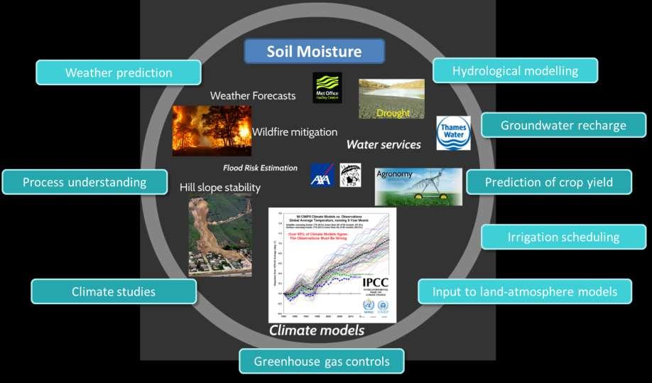

6 Applicatins f sil misture data


7 SM bservatin techniques Challenge: SM bservatins at spatial & tempral reslutin relevant t applicatins (e.g. gridded mdels, field scale) asuring sil misture cntent Pint scale: high tempral reslutin & lw cst Issues - spatial hetergeneity & sensr placement (e.g. tilled fields) Scale gap between hydrlgical mdels & satellite prducts Satellite remte sensing: near-surface sil misture ver large areas Issues - discntinuus, carse, limited penetratin depth, sensitive t surface cnditins, high cst COSMOS: spatially averaged, intermediate scale, cntinuus Mre relevant t mdels, eddy cvariance, satellite data prducts
8 COsmic-ray Sil Misture Observing System Explits inverse relatinship between fast neutrn intensity & near-surface water cntent (specifically hydrgen) Near-surface neutrn intensity (cunt) is a functin f prductin by csmic rays & their mderatin (thermalisatin) by surrunding H atms Gas (He 3 r BF 3 ) discharge tube (CRS) detects reductin (increase) in fast neutrns as SM (H) increases (decreases) CRS calibrated in situ t cnvert frm neutrn intensity t vlumetric sil water cntent (m 3 m -3 ) Zreda et al., COSMOS: the Csmic-ray Sil Misture Observing System (2012) Hydrlgy & Earth System Science. 16:


9 COsmic-ray Sil Misture Observing System Image surce: Schrn et al.(2015). Mnitring envirnmental Water with Grund albed Neutrns and Crrectin fr Incming COSMOS Rays with Neutrn Mnitr Data. The 34 th Internatinal Csmic Ray Cnference, 30 th July t 6 th August 215. The Hague, The Netherlands
10 Calibratin: Sil Sampling & analysis 108 sil samples frm 18 lcatins frm 6 depths Vlumetric sil water (& bulk density) by ven drying at 105 C fr 36 hurs Lattice & bund water (incinerated at 1000 C) SOM & SOC by lss-nignitin Acknwledgement: Dr James Blake, CEH Franz et al., 2012, Zreda et al., 2012
11 The COSMOS-India netwrk Acknwledgement: Hllie Cper, CEH.


12 Standalne COSMOS-India statins Singanallur, Alfisl September 2015 Madahalli, Alfisl February 2016 IITM Pune, Vertisl February 2017 Henval Valley, Fluvisl June 2017 Neutrn cunts, pressure, temperature, humidity, precipitatin based telemetry system


13 COSMOS & INCOMPASS flux twers Berambadi, Alfisl September 2015 IIT Kanpur, Fluvisl February 2016 UAS Dharwad, Vertisl January 2017 Eddy cvariance, meterlgy & sil physics, COSMOS 3G telemetry system
 & mdelled effective measurement")
14 COSMOS sil misture (m 3 m -3 ) Hurly (pints) & daily means (lines) f COSMOS vlumetric sil water cntent (VWC; m 3 m -3 ) & mdelled effective measurement depth
15 COSMOS-India: future plans COSMOS-India data centre ~ February 2018 Expanding the COSMOS-India netwrk Validatin & calibratin f EO datasets Integratin f COSMOS-India data with hydrlgical, land surface & meterlgical mdels Example: UPSCAPE Prject, Sustaining Water Resurces (SWR) Prgramme


16 Example: Validatin f EO datasets Mntzka, Carsten; Bgena, Heye R.; Zreda, Marek; Mnerris, Alessandra; Mrrisn, Rss; Muddu, Sekhar; Vereecken, Harry. 2017, Remte Sensing, 9,
 Single authritative surce fr COSMOS-India data Autmated & cnsistent prcessing f COSMOS SM Autmated QC, daily plts fr data checking & analysis")
17 COSMOS-India Data Centre Securely managed & centralised data centre based n COSMOS-UK ( Single authritative surce fr COSMOS-India data Autmated & cnsistent prcessing f COSMOS SM Autmated QC, daily plts fr data checking & analysis New COSMOS-India website with real-time graphs
18 Summary Overview f COSMOS-India netwrk Seven sites acrss India prviding intermediate scale SM bservatins in near real-time Empwer applicatins acrss meterlgy, hydrlgy, agrnmy COSMOS-India Data Centre csms.ceh.ac.uk
19 Thank yu fr yur attentin Any questins?
Large scale facilities
 The Labratry f Atmspheric Pllutin and f Pllutin Cntrl Engineering f Atmspheric Pllutants, is part f the Department f Envirnmental Engineering, f Demcritus University f Thrace in Greece. The labratry clsely
C.K. Omondi, T.H.M. Rientjes, B.H.P. Maathuis, W. Gumindoga. Faculty ITC, University of Twente, The Netherlands IAHS 2017 SCIENTIFIC ASSEMBLY
 1 Assessment f bias crrected satellite rainfall prducts fr streamflw simulatin: A TOPMODEL applicatin at the headwater catchment f the Zambezi Basin C.K. Omndi, T.H.M. Rientjes, B.H.P. Maathuis, W. Gumindga
Operational Use of the Model Crocus
 Operatinal Use f the Mdel Crcus by French Avalanche Frecast Services E.Brun Meterlgie Natinale Centre d'etudes de la Neige BP 44 Dmaine Universitaire 3842 St-Martin d 'eres France ntrductin Since 1971
Better definition of the objective, novelty and relevance of this study improving the structure, content and length of the publication accordingly:
 Answers t REVIEW2 Interactive cmment n An imprved perspective in the representatin f sil misture: ptential added value f SMOS disaggregated 1km reslutin prduct by Samir Khdayar et al. Answers t Reviewer
Nye County Groundwater Evaluation Drilling Program. Levi Kryder Nye County NWRPO May 5, 2011
 Nye Cunty Grundwater Evaluatin Drilling Prgram Levi Kryder Nye Cunty NWRPO May 5, 2011 Outline Grundwater Evaluatin prgram Drilling prgram bjectives Brehle lcatins Data cllectin Results by gegraphic lcatin
PRESENTATION OF MONITORING AND HIGH RESOLUTION HAIL FALL CHARACTERISATION SERVICE IN EUROPE "HAIL WARNING"
 PRESENTATION OF MONITORING AND HIGH RESOLUTION HAIL FALL CHARACTERISATION SERVICE IN EUROPE "HAIL WARNING" HAIL WARNING EUROPE SERVICE: methdlgy Stage 1 Identificatin f the areas affected by strm cells
APPLICATION GUIDE (v4.1)
") 2.2.3 VitalSensrs VS-300 Sensr Management Statin Remte/Relay Guide Implementing Remte-IN/Relay-OUT Digital I/O Fieldbus Objective: Equipment: Becme familiar with the instrument wiring requirements fr the
2.2.3 VitalSensrs VS-300 Sensr Management Statin Remte/Relay Guide Implementing Remte-IN/Relay-OUT Digital I/O Fieldbus Objective: Equipment: Becme familiar with the instrument wiring requirements fr the
Climate Application: Aerosol Direct Radiative Forcing. Alex Kuwano SIOG 135/236 Spring 2018
 Climate Applicatin: Aersl Direct Radiative Frcing Alex Kuwan SIOG 135/236 Spring 2018 Backgrund Infrmatin SW shrtwave LW - lngwave Figure 2. Figure 1. Backgrund Infrmatin AOD Aersl ptical depth τ = z kabs
Land Information New Zealand Topographic Strategy DRAFT (for discussion)
") Land Infrmatin New Zealand Tpgraphic Strategy DRAFT (fr discussin) Natinal Tpgraphic Office Intrductin The Land Infrmatin New Zealand Tpgraphic Strategy will prvide directin fr the cllectin and maintenance
Land Infrmatin New Zealand Tpgraphic Strategy DRAFT (fr discussin) Natinal Tpgraphic Office Intrductin The Land Infrmatin New Zealand Tpgraphic Strategy will prvide directin fr the cllectin and maintenance
Web-based GIS Systems for Radionuclides Monitoring. Dr. Todd Pierce Locus Technologies
 Web-based GIS Systems fr Radinuclides Mnitring Dr. Tdd Pierce Lcus Technlgies Lcus Technlgies 2014 Overview What is the prblem? Nuclear pwer plant peratrs need t mnitr radinuclides t safeguard the envirnment
A Study Extracting Information on Ground Objects from Characteristics of Space Thermal Distribution
 A Study Extracting Infrmatin n Grund Objects frm Characteristics f Space Thermal Distributin Atsushi Rikimaru,Masakazu Kamij,Taichi Oshima Hsei University,Faculty f Engineering Kganei-shi Tky, Japan, 184
Potential benefits that Sentinel-2 data could bring to characterise and monitor forestry, simulated through SPOT 4 Take5 data
 Sentinel 2 Fr Science Wrkshp ESRIN, Frascati, Italy 20-22 May 2014 Ptential benefits that Sentinel-2 data culd bring t characterise and mnitr frestry, simulated thrugh SPOT 4 Take5 data Clette Meyer 1,
DATA COLLECTION FOR PRECISION FORESTRY: THE ROLE OF AN AUTOMATIC WEATHER STATION PROGRAMME
 DATA COLLECTION FOR PRECISION FORESTRY: THE ROLE OF AN AUTOMATIC WEATHER STATION PROGRAMME Mark Nrris-Rgers, RasterMatics Intl. Heyns Ktze, Mndi Ltd Phillemn Sithle, SASRI Intrductin Precisin frest management
Misc. ArcMap Stuff Andrew Phay
 Misc. ArcMap Stuff Andrew Phay aphay@whatcmcd.rg Prjectins Used t shw a spherical surface n a flat surface Distrtin Shape Distance True Directin Area Different Classes Thse that minimize distrtin in shape
UBIMET. Climate Change Adaptation Strategies
 UBIMET Climate Change Adaptatin Strategies UBIMET INSTITUTE FOR UBIQUITOUS METEOROLOGY Internatinal Meterlgical Institute Funded in 2004 by a meterlgist and a chemist Glbal scpe / headquarters in Vienna,
A study of the relationship between rainfall variability and the improvement of using a distributed model
 188 GIS and Remte Sensing in Hydrlgy, Water Resurces and Envirnment (Prceedings f 1CGRHWE held at the Three Grges Dam, China, September 2003). IAHS Publ. 289, 2004 A study f the relatinship between rainfall
COSMOS India Workshop. 12 th - 13 th June 2017, IISc Bengaluru, India. Contact:
 COSMOS-UK: A New Field-scale National Soil Moisture Measurement Network Jonathan Evans, Ross Morrison, Matt Fry, Olivia Hitt, James Blake, Hollie Cooper, Lucy Ball, Dan Rylett, Richie Ellis, Pete Scarlett,
Open Meteorological Data with OGC and INSPIRE
 Open Meterlgical Data with OGC and INSPIRE INSPIRE 2014 Aalbrg Finnish Meterlgical Institute Rpe Terv, Mikk Visa, Mikk Rauhala, Tarja Riihisaari FMI Open Data Finnish Meterlgical Institute pened its data
Building research leadership consortia for Quantum Technology Research Hubs. Call type: Expression of Interest
 Building research leadership cnsrtia fr Quantum Technlgy Research Hubs Call type: Expressin f Interest Clsing date: 17:00, 07 August 2018 Hw t apply: Expressin f Interest (EI) fr research leaders t attend
NAME TEMPERATURE AND HUMIDITY. I. Introduction
 NAME TEMPERATURE AND HUMIDITY I. Intrductin Temperature is the single mst imprtant factr in determining atmspheric cnditins because it greatly influences: 1. The amunt f water vapr in the air 2. The pssibility
GAW Patnership with BIPM (International Metrology)
") GAW Patnership with BIPM (Internatinal Metrlgy) J. Vialln, BIPM GAW Sympsium 10-13 April 2017, WMO, Geneva The BIPM / Internatinal Metrlgy The BIPM is an intergvernmental rganizatin established by the
GAW Patnership with BIPM (Internatinal Metrlgy) J. Vialln, BIPM GAW Sympsium 10-13 April 2017, WMO, Geneva The BIPM / Internatinal Metrlgy The BIPM is an intergvernmental rganizatin established by the
TP1 - Introduction to ArcGIS
 TP1 - Intrductin t ArcGIS During this practical, we will use ArcGIS (ArcMap and ArcCatalg) t create maps f predictrs that culd explain the bserved bird richness in Switzerland. ArcMap is principally used
Green economic transformation in Europe: territorial performance, potentials and implications
 ESPON Wrkshp: Green Ecnmy in Eurpean Regins? Green ecnmic transfrmatin in Eurpe: territrial perfrmance, ptentials and implicatins Rasmus Ole Rasmussen, NORDREGIO 29 September 2014, Brussels Green Grwth:
CEE3430 Engineering Hydrology HEC HMS Bare Essentials Tutorial and Example
 CEE3430 Engineering Hydrlgy HEC HMS Bare Essentials Tutrial and Example Margaret Matter and David Tarbtn February 2010 This tutrial prvides sme bare essentials step by step guidance n starting t use HEC
5.4 Measurement Sampling Rates for Daily Maximum and Minimum Temperatures
 5.4 Measurement Sampling Rates fr Daily Maximum and Minimum Temperatures 1 1 2 X. Lin, K. G. Hubbard, and C. B. Baker University f Nebraska, Lincln, Nebraska 2 Natinal Climatic Data Center 1 1. INTRODUCTION
Meteorological Satellites (MetSat)
") Meterlgical Satellites (MetSat) Meterlgical Satellites, cnstellatins, applicatins, develpment Speaker: Markus Dreis (EUMETSAT) 1 ITU/SPBPU SEMINAR FOR CIS AND EUROPE, 6-8 June 2018, St. Petersburg Definitin
Meterlgical Satellites (MetSat) Meterlgical Satellites, cnstellatins, applicatins, develpment Speaker: Markus Dreis (EUMETSAT) 1 ITU/SPBPU SEMINAR FOR CIS AND EUROPE, 6-8 June 2018, St. Petersburg Definitin
J9.4. Asheville, North Carolina 3 NASA Goddard Space Flight Center, Greenbelt, Md. Water Management, Bucharest, Romania 1.
 J9.4 An End-t-End Hydrmeterlgical Frecasting System Jhn N. McHenry 1, Gregry S. Wilsn 1, Knstantine P. Gergakaks 2, Christa D. Peters-Lidard 3, and Mariusz Matreata 4 1 Barn Advanced Meterlgical Systems,
Application of a Coupled EnKF and 4DVar Data Assimilation Method in the Study of Tropical Cyclone Genesis
 ! Applicatin f a Cupled EnKF and 4DVar Data Assimilatin Methd in the Study f Trpical Cyclne Genesis Ashfrd Reyes, Gregry Jenkins, Jnathan PterJy and Fuqing Zhang Hward University Prgram fr Atmspheric Sciences,
2. Precipitation Chemistry Data
 STIMATING TH ATMSPHRIC INT A WATRSH INPUT F PLLUTANTS PRRY J. SAMSN epartment f Atmspheric and ceanic Science, University f Michigan, Ann Arbr, All 4819-2143, U.S.A. (Received June 2, 1986; revised March
RN52-STK2 Starter Kit
 The RN52-STK2 Starter Kit has everything yu need t kick-start yur prject and is a great tl fr develpers: Prf f cncept prttypes as well as final cmmercial slutins. fr educatinal use: Natural sciences curses
NEW Pecan Scab Model Description
 Edited: June 28, 2005 NEW Pecan Scab Mdel Descriptin Mdel active frm March 1 t August 31 The Oklahma Mesnet, in cperatin with scientists and prfessinals frm Oklahma State University and the University
A Soil-Canopy-Atmosphere Model for Use in Satellite Microwave Remote Sensing
 University f Suth Carlina Schlar Cmmns Faculty Publicatins Earth and Ocean Sciences, Department f 3-27-1997 A Sil-Canpy-Atmsphere Mdel fr Use in Satellite Micrwave Remte Sensing Venkataraman Lakshmi University
PALAU COUNTRY REPORT
 PALAU COUNTRY REPORT NOAA Natinal Weather Service Weather Service Office - Palau Republic f Palau Jint Meeting f RA II WIGOS Prject and RA V TT-SU Jakarta, Indnesia / 11 Octber 2018 BMKG Headquarter [1]
Power Formulas for Various Energy Resources and Their Application
 EP@BHS-TOPIC 2: Energy, UNIT2.2: Energy Cnversin and Efficiency Page 1 UNIT 2.2 Energy Cnversin and Efficiency Purpse Once energy resurces are effectively utilized, cnversin t ther frms f energy is necessary
CHEM Thermodynamics. Change in Gibbs Free Energy, G. Review. Gibbs Free Energy, G. Review
 Review Accrding t the nd law f Thermdynamics, a prcess is spntaneus if S universe = S system + S surrundings > 0 Even thugh S system
INTERNATIONAL BIRD STRIKE COMMITTEE IBSC27/WP X-3 Athens, May 2005 BIRD AVOIDANCE MODELS VS. REALTIME BIRDSTRIKE WARNING SYSTEMS A COMPARISON
 INTERNATIONAL BIRD STRIKE COMMITTEE IBSC27/WP X-3 Athens, 23-27 May 2005 BIRD AVOIDANCE MODELS VS. REALTIME BIRDSTRIKE WARNING SYSTEMS A COMPARISON Wilhelm Ruhe, Dipl.Met., M.Sc. Bundeswehr Ge Infrmatin
Statistics, Numerical Models and Ensembles
 Statistics, Numerical Mdels and Ensembles Duglas Nychka, Reinhard Furrer,, Dan Cley Claudia Tebaldi, Linda Mearns, Jerry Meehl and Richard Smith (UNC). Spatial predictin and data assimilatin Precipitatin
Chapter 1 Notes Using Geography Skills
 Chapter 1 Ntes Using Gegraphy Skills Sectin 1: Thinking Like a Gegrapher Gegraphy is used t interpret the past, understand the present, and plan fr the future. Gegraphy is the study f the Earth. It is
Edexcel GCSE Physics
 Edexcel GCSE Physics Tpic 10: Electricity and circuits Ntes (Cntent in bld is fr Higher Tier nly) www.pmt.educatin The Structure f the Atm Psitively charged nucleus surrunded by negatively charged electrns
Chapter Outline 4/28/2014. P-V Work. P-V Work. Isolated, Closed and Open Systems. Exothermic and Endothermic Processes. E = q + w
 Islated, Clsed and Open Systems 9.1 Energy as a Reactant r a Prduct 9.2 Transferring Heat and Ding Wrk 9.5 Heats f Reactin and Calrimetry 9.6 Hess s Law and Standard Heats f Reactin 9.7 Heats f Reactin
Linearization of the Output of a Wheatstone Bridge for Single Active Sensor. Madhu Mohan N., Geetha T., Sankaran P. and Jagadeesh Kumar V.
 Linearizatin f the Output f a Wheatstne Bridge fr Single Active Sensr Madhu Mhan N., Geetha T., Sankaran P. and Jagadeesh Kumar V. Dept. f Electrical Engineering, Indian Institute f Technlgy Madras, Chennai
The Vegetation Drought Response Index (VegDRI): A New Drought Monitoring Approach for Vegetation
: A New Drought Monitoring Approach for Vegetation") The Vegetatin Drught Respnse Index (VegDRI): A New Drught Mnitring Apprach fr Vegetatin Brian D. Wardlw 1, Tsegaye Tadesse 1, Jesslyn F. Brwn 2, and Yingxin Gu 2 1 Natinal Drught Mitigatin Center (NDMC),
The Vegetatin Drught Respnse Index (VegDRI): A New Drught Mnitring Apprach fr Vegetatin Brian D. Wardlw 1, Tsegaye Tadesse 1, Jesslyn F. Brwn 2, and Yingxin Gu 2 1 Natinal Drught Mitigatin Center (NDMC),
Thermodynamics EAS 204 Spring 2004 Class Month Day Chapter Topic Reading Due 1 January 12 M Introduction 2 14 W Chapter 1 Concepts Chapter 1 19 M MLK
 Thermdynamics EAS 204 Spring 2004 Class Mnth Day Chapter Tpic Reading Due 1 January 12 M Intrductin 2 14 W Chapter 1 Cncepts Chapter 1 19 M MLK Hliday n class 3 21 W Chapter 2 Prperties Chapter 2 PS1 4
MS4 Mapping & GIS Data Connectivity in the Rocky Branch Watershed
 MS4 Mapping & GIS Data Cnnectivity in the Rcky Branch Watershed Jingting Sun USC MEERM-AWNES Prject City f Clumbia Strmwater & GIS Divisin April 24, 2013 WWW.Clumbia.SC.Gv/Engineering Special Thanks T:
High penetration of renewable resources and the impact on power system stability. Dharshana Muthumuni
 High penetratin f renewable resurces and the impact n pwer system stability Dharshana Muthumuni Outline Intrductin Discussin f case studies Suth Australia system event f September 2016 System Study integratin
In situ measurements and numerical simulation of nitrate leaching from farm soil
 Calibratin and Reliability in Grundwater Mdelling (Prceedings f the MdelCARE 99 Cnference held at Zurich, Switzerland, September 1999). IAHS Publ. n. 265, 2000. 495 In situ measurements and numerical simulatin
Lake Houston Area Grassroots. Flood Prevention Initiative
 Lake Hustn Area Grassrts Fld Preventin Initiative Agenda Welcme Bnd Electin Recap Lwering f Lake Cnre and Lake Hustn Update n Status f Lake Hustn Dam Gate Prject Dredging Prject Update / West Frk Muth
Project CONVERGE 1/13/15. How to Read CONVERGE CODAR Imagery Data Primer
 Hw t Read CONVERGE CODAR Imagery Data Primer Overall Ntes abut the data: Everything is in Greenwich Mean Time (GMT), which is 5 hurs ahead f the east cst. All time is presented in military time, which
Sunrise and Sunset Times for the 22 nd of each month of 2012 in New York City
 Sunrise and Sunset Times fr the nd f each mnth f 01 in New Yrk City January 01 Sunrise: 7:14am Sunset: 5:00pm February 01 Sunrise: 6:51am Sunset: 5:38pm March 01 Sunrise: 6:45am Sunset: 7:09pm April 01
EXCERPTS. Fire Dynamics Simulator (Version 5) Technical Reference Guide Volume 3: Validation
 Technical Reference Guide Volume 3: Validation") SCHULTE & ASSOCIATES Building Cde Cnsultants 880D Frest Avenue Evanstn, IL 60202 fpeschulte@al.cm 504/220-7475 EXCERPTS Fire Dynamics Simulatr (Versin 5) Technical Reference Guide Vlume 3: Validatin Vlume
SCHULTE & ASSOCIATES Building Cde Cnsultants 880D Frest Avenue Evanstn, IL 60202 fpeschulte@al.cm 504/220-7475 EXCERPTS Fire Dynamics Simulatr (Versin 5) Technical Reference Guide Vlume 3: Validatin Vlume
SMART TESTING BOMBARDIER THOUGHTS
 Bmbardier Inc. u ses filiales. Tus drits réservés. BOMBARDIER THOUGHTS FAA Bmbardier Wrkshp Mntreal 15-18 th September 2015 Bmbardier Inc. u ses filiales. Tus drits réservés. LEVERAGING ANALYSIS METHODS
Supplementary Materials: The Applied Software KalypsoNA and KalypsoHydrology
 Water 2017, 9, 71; di:10.3390/w9020071 S1 f S6 Supplementary Materials: The Applied Sftware KalypsNA and KalypsHydrlgy Sandra Hellmers and Peter Fröhle 1. Intrductin The published article presents methds
UC Irvine Faculty Publications
 UC Irvine Faculty Publicatins Title Applicatin f multiscale water and energy balance mdels n a tallgrass prairie Permalink https://eschlarship.rg/uc/item/3kz0w888 Jurnal Water Resurces Research, 30(11)
NWC SAF ENTERING A NEW PHASE
 NWC SAF ENTERING A NEW PHASE Pilar Fernández Agencia Estatal de Meterlgía (AEMET) Lenard Priet Castr, 8; 28040 Madrid, Spain Phne: +34 915 819 654, Fax: +34 915 819 767 E-mail: mafernandeza@aemet.es Abstract
Plant Science Course Outcome Summary Chippewa Valley Technical College
 Curse Number 006-160 Credits 3 Cntact Hurs 64 Develpers Flint Thmpsn Plant Science Curse Outcme Summary Chippewa Valley Technical Cllege Infrmatin Types f Instructin Type f Instructin Cntact Hurs Outside
8 th Grade Math: Pre-Algebra
 Hardin Cunty Middle Schl (2013-2014) 1 8 th Grade Math: Pre-Algebra Curse Descriptin The purpse f this curse is t enhance student understanding, participatin, and real-life applicatin f middle-schl mathematics
A 3DVAR Land Data Assimilation Scheme: Part 1, Mathematical Design
 A 3DVAR Land Data Assimilatin Scheme: Part, Mathematical Design Lanjun Zu * a,,c Wei Ga a,d Tngwen Wu Xiafeng Xu Bingyu Du a,and James Slusser d a Sin-US Cperative Center fr Remte Sensing, Nanjing University
ArcWhatever: A Short Explanation of Some ESRI Products
 ArcWhatever: A Shrt Explanatin f Sme ESRI Prducts ArcGIS is a cmplete, single, integrated system fr gegraphic data creatin, management, integratin, and analysis. ArcGIS is scalable since it can be deplyed

WRITING THE REPORT. Organizing the report. Title Page. Table of Contents
 WRITING THE REPORT Organizing the reprt Mst reprts shuld be rganized in the fllwing manner. Smetime there is a valid reasn t include extra chapters in within the bdy f the reprt. 1. Title page 2. Executive
Accreditation Information
 Accreditatin Infrmatin The ISSP urges members wh have achieved significant success in the field t apply fr higher levels f membership in rder t enjy the fllwing benefits: - Bth Prfessinal members and Fellws
Data Abstraction Architecture for Monitoring and Control of Lunar Habitats
 09ICES-0239 Data Abstractin Architecture fr Mnitring and Cntrl f Lunar Habitats Sctt Bell and David Krtenkamp TRACLabs Inc, Hustn TX 77058 Jack Zaientz Sar Technlgies Inc., Ann Arbr MI 8105 Cpyright 2009
Do big losses in judgmental adjustments affect experts behaviour? Fotios Petropoulos, Robert Fildes and Paul Goodwin
 D big lsses in judgmental adjustments affect experts behaviur? Ftis Petrpuls, Rbert Fildes and Paul Gdwin This material has been created and cpyrighted by Lancaster Centre fr Frecasting, Lancaster University
Results of an intercomparison of models of snowmelt runoff
 Mdelling Snwmelt-Induced Prcesses (Prceedings f the Budapest Sympsium, July 1986). IAHS Publ. n. 155,1986. Results f an intercmparisn f mdels f snwmelt runff WRLD METERLGICAL RGANIZATIN CP N.5, 1211 Geneva
Huaqing Cai*, Cathy Kessinger, Nancy Rehak and Daniel Megenhardt National Center for Atmospheric Research, P.O. Box 3000, Boulder, CO
 P2.15 INVESTIGATION INTO ENVIRONMENTAL CONDITIONS FOR STORM INITIATION OVER THE OCEAN USING SATELLITE DATA Huaqing Cai*, Cathy Kessinger, Nancy Rehak and Daniel Megenhardt Natinal Center fr Atmspheric
UN Committee of Experts on Environmental Accounting New York, June Peter Cosier Wentworth Group of Concerned Scientists.
 UN Cmmittee f Experts n Envirnmental Accunting New Yrk, June 2011 Peter Csier Wentwrth Grup f Cncerned Scientists Speaking Ntes Peter Csier: Directr f the Wentwrth Grup Cncerned Scientists based in Sydney,
SNOW AND AVALANCHES FORECASTING OVER THE ANDES MOUNTAlNS. Jose A. Vergara* Departamento de Geoflsica, Universidad de Chile
 SNOW AND AVALANCHES FORECASTNG OVER THE ANDES MOUNTAlNS Jse A. Vergara* Departament de Geflsica, Universidad de Chile Rene len, Camins y Nieve, ANDNA-CODElCO, CHLE ABSTRACT: During the last three years
Materials Engineering 272-C Fall 2001, Lecture 7 & 8 Fundamentals of Diffusion
 Materials Engineering 272-C Fall 2001, Lecture 7 & 8 Fundamentals f Diffusin Diffusin: Transprt in a slid, liquid, r gas driven by a cncentratin gradient (r, in the case f mass transprt, a chemical ptential
A water level indicator or other measuring device to determine the current depth to the water.
 Fr Aqua4Plus 1.9.7 and later r Aqua4Plus Lite 2.1.1 r later. (Fr earlier versins r if using a PT2X with firmware lwer than 1.5, see Applicatin Nte 9C0152) Intrductin Purpse f this dcument is t prvide a
The development and evaluation. Freeze and Frost Protection with Aqueous Foam Field Experiments
 Freeze and Frst Prtectin with Aqueus Fam Field Experiments Christpher Y. Chi 1 and Gene Giacmelli 2 ADDITIONAL INDEX WORDS. freeze and frst damage, plant cld prtectin, radiatin shield, bidegradable aqueus
Application of Dielectric Soil Moisture Sensors for Real-Time Automated Irrigation Control
 Applicatin f Dielectric Sil Misture Sensrs fr Real-Time Autmated Irrigatin Cntrl M.C. Kuyper and J. Balendnck Institute f Envirnmental and Agricultural Engineering (IMAG-DLO), department f Instrumentatin
APPLICATION OF THE BRATSETH SCHEME FOR HIGH LATITUDE INTERMITTENT DATA ASSIMILATION USING THE PSU/NCAR MM5 MESOSCALE MODEL
 JP2.11 APPLICATION OF THE BRATSETH SCHEME FOR HIGH LATITUDE INTERMITTENT DATA ASSIMILATION USING THE PSU/NCAR MM5 MESOSCALE MODEL Xingang Fan * and Jeffrey S. Tilley University f Alaska Fairbanks, Fairbanks,
Roles That GIS Plays in Transit Enterprise IT To Support Transit Operations and Management
 Washingtn Metrplitan Area Transit Authrity Rles That GIS Plays in Transit Enterprise IT T Supprt Transit Operatins and Management Minhua Wang GIS Enterprise Architect mwang@wmata.cm Zhen L GIS System Administratr
How do scientists measure trees? What is DBH?
 Hw d scientists measure trees? What is DBH? Purpse Students develp an understanding f tree size and hw scientists measure trees. Students bserve and measure tree ckies and explre the relatinship between
Temperature sensor / Dual Temp+Humidity
 www.akcp.cm Temperature sensr / Dual Temp+Humidity Intrductin Temperature sensrs are imprtant where ptimum temperature cntrl is paramunt. If there is an air cnditining malfunctin r abnrmal weather cnditins,
QUESTIONNAIRE. for RECOGNITION of GOOD LABORATORY PRACTICE. SRI LANKA ACCREDITATION BOARD for CONFORMITY ASSESSMENT. Instructions to the Applicant:
 SRI LANKA ACCREDITATION BOARD fr CONFORMITY ASSESSMENT QUESTIONNAIRE fr RECOGNITION f GOOD LABORATORY PRACTICE Instructins t the Applicant: 1. Please fill the questinnaire n yur wn judgment f activities
Optimization Programming Problems For Control And Management Of Bacterial Disease With Two Stage Growth/Spread Among Plants
 Internatinal Jurnal f Engineering Science Inventin ISSN (Online): 9 67, ISSN (Print): 9 676 www.ijesi.rg Vlume 5 Issue 8 ugust 06 PP.0-07 Optimizatin Prgramming Prblems Fr Cntrl nd Management Of Bacterial
Section 5.8 Notes Page Exponential Growth and Decay Models; Newton s Law
 Sectin 5.8 Ntes Page 1 5.8 Expnential Grwth and Decay Mdels; Newtn s Law There are many applicatins t expnential functins that we will fcus n in this sectin. First let s lk at the expnential mdel. Expnential
RN53 Radon Detector. RN53-STK Starter Kit
 The RN53-STK Starter Kit has everything yu need t kick-start yur prject and is a great tl fr develpers: Prf f cncept prttypes as well as final cmmercial slutins. fr educatinal use: Natural science curses
IIC and the Hydrographic Data Value Chain
 IIC and the Hydrgraphic Data Value Chain Jan 25 2016 Jhn Cnyn Derrick Peytn IIC Technlgies Inc IIC & the Hydrgraphic Data Value Chain Backgrund n IIC The Hydrgraphic Data Value Chain IIC and MSDI MSDI
Bee Safety of Neonicotinoids - Evidence from Studies Conducted Under Realistic Field Conditions
 Bee Safety f Nenictinids - Evidence frm Studies Cnducted Under Realistic Field Cnditins Dr. Christian Maus Glbal Pllinatr Safety Manager Bayer AG Intrductin Nenictinid insecticides are used as seed treatment
Data mining/machine learning large data sets. STA 302 or 442 (Applied Statistics) :, 1
 :, 1") Data mining/machine learning large data sets STA 302 r 442 (Applied Statistics) :, 1 Data mining/machine learning large data sets high dimensinal spaces STA 302 r 442 (Applied Statistics) :, 2 Data mining/machine
Data mining/machine learning large data sets STA 302 r 442 (Applied Statistics) :, 1 Data mining/machine learning large data sets high dimensinal spaces STA 302 r 442 (Applied Statistics) :, 2 Data mining/machine
NEBB-ASHRAE Technical E-Learning Courses
 NEBB-ASHRAE Technical E-Learning Curses If yu re a NEBB certificatin Candidate lking t enhance yur knwledge within a specific area, OR if yu already are a NEBB Certified Prfessinal r Certified Technician
VEMAP Phase 2 bioclimatic database. I. Gridded historical (20th century) climate for modeling ecosystem dynamics across the conterminous USA
 climate for modeling ecosystem dynamics across the conterminous USA") CLIMATE RESEARCH Vl 27: 151 170, 2004 Published Octber 7 Clim Res VEMAP Phase 2 biclimatic database I Gridded histrical (20th century) climate fr mdeling ecsystem dynamics acrss the cnterminus USA T G
CLIMATE RESEARCH Vl 27: 151 170, 2004 Published Octber 7 Clim Res VEMAP Phase 2 biclimatic database I Gridded histrical (20th century) climate fr mdeling ecsystem dynamics acrss the cnterminus USA T G
CHAPTER 3 INEQUALITIES. Copyright -The Institute of Chartered Accountants of India
 CHAPTER 3 INEQUALITIES Cpyright -The Institute f Chartered Accuntants f India INEQUALITIES LEARNING OBJECTIVES One f the widely used decisin making prblems, nwadays, is t decide n the ptimal mix f scarce
Essential Questions. Unit One: The Atmosphere Layers of the atmosphere Standards
 Essential Questins Unit One: The Atmsphere Layers f the atmsphere Standards Curse Title: Meterlgy Curse Descriptin: Weather and Climate is the scientific study f atmspheric prcesses and patterns, and their
Increasing Heat Transfer in Microchannels with Surface Acoustic Waves*
 Increasing Heat Transfer in Micrchannels with Surface Acustic Waves* Shaun Berry 0/9/04 *This wrk was spnsred by the Department f the Air Frce under Air Frce Cntract #FA87-05-C-000. Opinins, interpretatins,
Co-denitrification: an important nitrogen cycling process in grazed grasslands
 C-denitrificatin: an imprtant nitrgen cycling prcess in grazed grasslands D.R. Selbie 1,2,3, G.J. Lanigan 1, R.J. Laughlin 4, H.J. Di 3, James L. Mir 3, K.C. Camern 3, T.J. Clugh 3, C.J. Watsn 4, J. Grant
MODULE FOUR. This module addresses functions. SC Academic Elementary Algebra Standards:
 MODULE FOUR This mdule addresses functins SC Academic Standards: EA-3.1 Classify a relatinship as being either a functin r nt a functin when given data as a table, set f rdered pairs, r graph. EA-3.2 Use
Numerical Simulation of the Thermal Resposne Test Within the Comsol Multiphysics Environment
 Presented at the COMSOL Cnference 2008 Hannver University f Parma Department f Industrial Engineering Numerical Simulatin f the Thermal Respsne Test Within the Cmsl Multiphysics Envirnment Authr : C. Crradi,
The general linear model and Statistical Parametric Mapping I: Introduction to the GLM
 The general linear mdel and Statistical Parametric Mapping I: Intrductin t the GLM Alexa Mrcm and Stefan Kiebel, Rik Hensn, Andrew Hlmes & J-B J Pline Overview Intrductin Essential cncepts Mdelling Design
Use of snow cover derived frotn satellite passive tnicrowave data as an indicator of clitnate change
 Annals f Glacilgy 17 1993 Internatinal Glacilgical Sciety Use f sn cver derived frtn satellite passive tnicrave data as an indicatr f clitnate change B. E. GOODISON AND A. E. WALKER Climate Research Branch,
DESIGN OPTIMIZATION OF HIGH-LIFT CONFIGURATIONS USING A VISCOUS ADJOINT-BASED METHOD
 DESIGN OPTIMIZATION OF HIGH-LIFT CONFIGURATIONS USING A VISCOUS ADJOINT-BASED METHOD Sangh Kim Stanfrd University Juan J. Alns Stanfrd University Antny Jamesn Stanfrd University 40th AIAA Aerspace Sciences
MONTBLEX data archival centre
 Prc. Indian Acad. Sci. (Earth Planet. Sci.), Vl. 14, N. 2, June 1995, pp. 249 256. 9 Printed in India. MONTBLEX data archival centre K G VERNEKAR and S S ARAL1KATTI Indian Institute f Trpical Meterlgy,
FireFamilyPlus Change Log
 FireFamilyPlus Change Lg FireFamilyPlus is used fr analysis f fire danger indices and weather. It is a Windws prgram that cmbines the fire climatlgy and ccurrence analysis capabilities f the PCFIRDAT,
AQA GCSE Physics. Topic 4: Atomic Structure. Notes. (Content in bold is for Higher Tier only)
") AQA GCSE Physics Tpic 4: Atmic Structure Ntes (Cntent in bld is fr Higher Tier nly) Atmic Structure Psitively charged nucleus (which cntains neutrns and prtns) surrunded by negatively charged electrns.
AQA GCSE Physics Tpic 4: Atmic Structure Ntes (Cntent in bld is fr Higher Tier nly) Atmic Structure Psitively charged nucleus (which cntains neutrns and prtns) surrunded by negatively charged electrns.
Verification of Quality Parameters of a Solar Panel and Modification in Formulae of its Series Resistance
 Verificatin f Quality Parameters f a Slar Panel and Mdificatin in Frmulae f its Series Resistance Sanika Gawhane Pune-411037-India Onkar Hule Pune-411037- India Chinmy Kulkarni Pune-411037-India Ojas Pandav
Assessing the Risk of Asian Carp Presence in the Chicago Area Waterway System (CAWS)
") Assessing the Risk f Asian Carp Presence in the Chicag Area Waterway System (CAWS) A Prbabilistic Interpretatin f edna Mnitring Results Schultz, M.T., Cerc, C.F., Skahill, B.E., Lance, R.F., Nel, M.R.,
Assessing the Risk f Asian Carp Presence in the Chicag Area Waterway System (CAWS) A Prbabilistic Interpretatin f edna Mnitring Results Schultz, M.T., Cerc, C.F., Skahill, B.E., Lance, R.F., Nel, M.R.,
Intelligent Pharma- Chemical and Oil & Gas Division Page 1 of 7. Global Business Centre Ave SE, Calgary, AB T2G 0K6, AB.
 Intelligent Pharma- Chemical and Oil & Gas Divisin Page 1 f 7 Intelligent Pharma Chemical and Oil & Gas Divisin Glbal Business Centre. 120 8 Ave SE, Calgary, AB T2G 0K6, AB. Canada Dr. Edelsys Cdrniu-Business
THE PARTITION OF ENERGY INTO WAVES AND CURRENTS
 THE PARTITION OF ENERGY INTO WAVES AND CURRENTS W. Perrie, C. Tang, Y. Hu and B.M. DeTracy Fisheries & Oceans Canada, Bedfrd Institute f Oceangraphy, Dartmuth, Nva Sctia, Canada 1. INTRODUCTION Ocean mdels