PALAU COUNTRY REPORT
|
|
|
- Janice Morgan
- 5 years ago
- Views:
Transcription
1 PALAU COUNTRY REPORT NOAA Natinal Weather Service Weather Service Office - Palau Republic f Palau Jint Meeting f RA II WIGOS Prject and RA V TT-SU Jakarta, Indnesia / 11 Octber 2018 BMKG Headquarter [1] Yur cuntry reprts will be psted n the meeting's web page.
2 Backgrund The Republic f Palau cnsists f eight principal islands and mre than 250 smaller nes lying rughly 500 miles sutheast f the Philippines. The islands f Palau cnstitute part f the Carline Islands chain. Palau is an archipelag f ver 500 islands, part f the Micrnesia regin in the western Pacific Ocean. Krr Island is hme t the frmer capital, als named Krr, and is the islands cmmercial center. The larger Babeldab has the present capital, Ngerulmud, plus muntains and sandy beaches n its east cast. In its nrth, ancient basalt mnliths knwn as Badrulchau lie in grassy fields surrunded by palm trees. Ppulatin: 21,503 (2016) Wrld Bank Official languages: English, Palauan Recgnized reginal languages: Japanese; Snsrlese; Tbian Climate: Pleasantly warm climate year-rund with an annual mean temperature f 82 F (27 C). Rainfall can ccur thrughut the year and the annual average is 150 inches. The average relative humidity is 82% and althugh rain falls mre frequently between July and Octber, there is still much sunshine.
3 Our Missin: Shrt Descriptin f NMHS Activities Prvide weather, water, and climate data, frecasts and warnings fr the prtectin f life and prperty and enhancement f the natinal ecnmy. We build partnerships with state and natinal agencies, law enfrcement, academia, media and the public. We prvide ur partners with weather infrmatin and frecasts t make ur cmmunities increasingly ready, resilient, and respnsive when hazardus weather strikes.
4 Majr natinal ecnmic sectrs relying n NMHSs Natinal Emergency Management Office Bureau f Public Safety Divisin f Fire & Rescue Ministry f Health Ministry f Educatin Bureau f Agriculture Divisin f Transprtatin Divisin f Marine Law Enfrcement Krr State Rangers Other State Rangers Bureau f Agriculture Other Private Sectrs Media
5 Current Observatinal System Overview I. Surface bservatins The synptic surface weather bserving prgram exists t prvide weather data t supprt frecast prgrams. Weather data are encded in a numeric frmat fr internatinal exchange, at the main synptic reprting times f 0300, 0900, 1500 and 2100 UTC. Synptic surface bservatins include, at a minimum, infrmatin n amunt f sky cver, wind, visibility, temperature, pressure and weather. II. Upper-air bservatins The upper-air bserving prgram is dne twice daily at 0000 and 1200 UTC, unless extenuating and justifiable circumstances prevent it. The system utilized is the Transitinal Radisnde Observing System (TROS) with a 403 MHz frequency, t prvide a vertical prfile f pressure, temperature, relative humidity and wind velcity thrugh the use f balln burne radisnde. III. Marine bservatins Palau lacks marine bservatin equipment. There are n cean buys arund Palau. There is a tide gauge in Malakal maintained and perated by University f Hawaii at Mana in clse assciatin with ther agencies, ne being NOAA. Lcally, tide data is used t mnitr earthquake generated tsunami events. Reginally, tide data is used in assimilatin int peratinal mdels, calibratin f satellite altimetry data, prductin f ceanic prducts and research. Palau s cral research centers may have mre cean bserving equipment but it is nt accessible t public users. Frecasters have t result t mdel data t frecast marine cnditins. Surf bservatins are reprted every 0900 and 1500 UTC frm the east and suth side f Palau.
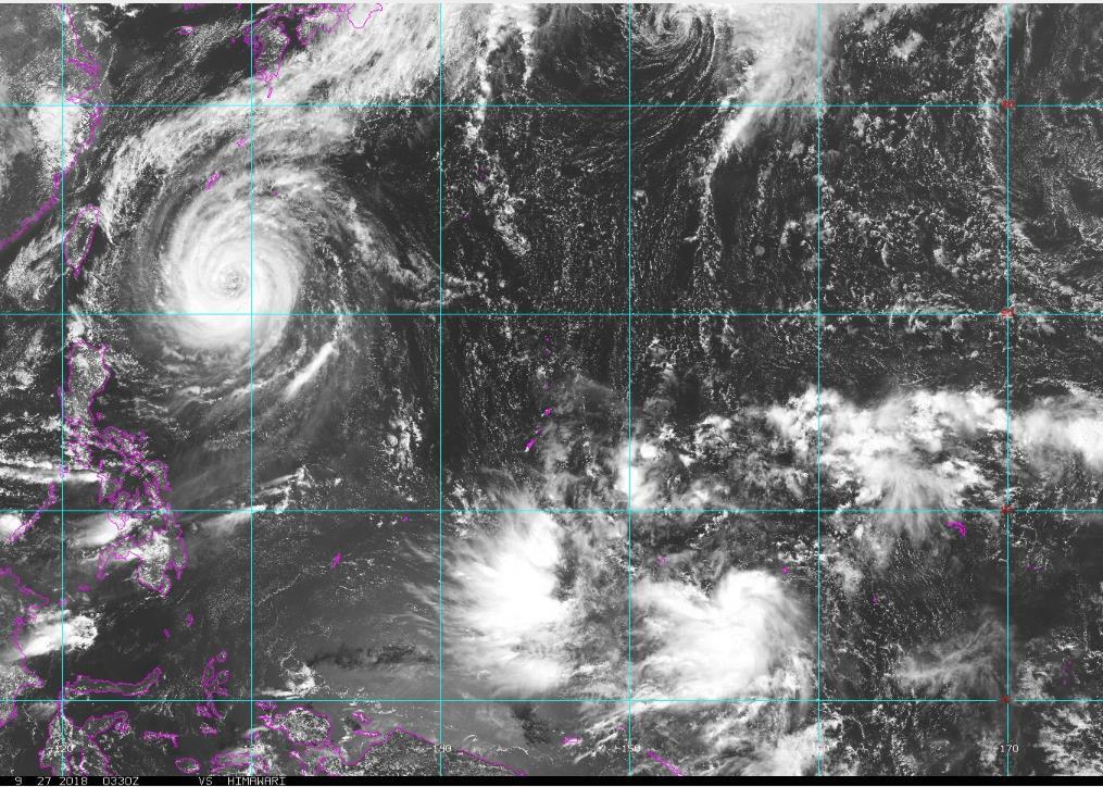
6 Current Observatinal System Overview IV. Aircraft-based bservatins Nt applicable V. Satellite bservatins The NOAA Gegstatinary satellite and the Japan Meterlgical Agency s Satellite Meterlgical Center s HimawariCast Satellite Receptin system with Sataid prgrams are used t bserve and analyze surface and upper air interactins with land and cean, and mnitr weather and climate cnditins. VI. Weather Radar bservatins Nt applicable VII. Other bservatin platfrms Cp statins frm tw ther lcatins bserve and reprt daily minimum and maximum temperatures.
7 Majr histrical hydr-meterlgical disasters Drught Episde 2016 Palau cngress apprpriated US$2 millin fr relief effrts. N casualties Super Typhn Hayian Nvember 7, 2013 Ttal damage estimated t US$ 5.9 millin in damages acrss six sectrs (Educatin, Utilities, Health, Agriculture, Public Wrks, Husing) N casualties. Super Typhn Bpha December 2, 2012 Ttal damage amunted t US$10.1 millin with repair csts estimated at US$15-20 millin; Palau cngress allcated US$10 millin fr relief while internatinal dnrs prvided a cllective $235,000 in aid. N casulaties.
8 Access, Prcessing and Applicatin f Satellite Data and Prducts I. List f satellites/instruments currently used peratinally fr NWP, nwcasting and ther applicatins NOAA Gestatinary and Plar Orbiting Satellites Himawari Satellite Receptin (Himawaricast) system with SATAID prgram Japan Meterlgical Agency Meterlgical Satellite Center (JMA MSC) Himawari Real Time (n line) AAFB Guam Radar Taiwan Central Weather Bureau (CWB) and Philippine (PAGASA) Satellite Images Other cuntries satellite images which includes ROP that can ffer mre infrmatin than the nes currently listed abve II. Current capabilities f access, prcessing and archiving f satellite data and prducts Himawaricast received thrugh JMA s cmmunicatin satellite Surface Analysis n lw and high reslutin images N archiving unless it is a used t prvide a weather briefing r it is a ptential hazard t Palau Internet surces On line surces used t lp images faster t be able t see clud develpment and dissipatin. Used t get mre specific details and infrmatin n a weather phenmenn mainly a trpical cyclne N archiving unless it is a used t prvide a weather briefing r it is a ptential hazard t Palau
9 Access, Prcessing and Applicatin f Satellite Data and Prducts I. Current satellite data applicatins I. Key applicatin areas II. Mnitring Weather and Climate cnditins Intertrpical cnvergence znes: Trpical Cyclnes, circulatins, disturbances, trughs, shear lines, frntal systems Mnsn: surges, depressins and trughs Observing and analyzing surface and upper air interactins with land and cean Satellite-based prducts Visible Imagery Infrared Imagery Near Infrared Imagery Water Vapr Imagery ASCAT Wind Data Micrwave Imagery Alitimeter Data
10 Abstract (updates n status and plan f satellite data access, prcessing, applicatin and training) WSO Palau utilizes Japan Meterlgical Agency s (JMA) Satellite Meterlgical Center s HimawariCast Satellite Receptin system with Sataid prgram t bserve and analyze near real time satellite images that are nly 10 minutes behind the actual time. Surf analysis are dne n bth lw and high reslutin images with an verlay f JMA s numerical weather predictin mdels and ASCAT plar rbiting data fr cean surface winds, respectively. This infrmatin is used with varius surces t prduce a lcal frecast. NOAA Gegstatinary satellite data are als used in peratins. Althugh it may be minutes behind, it can be lped faster than HimawariCast. Training is limited t JMA and NOAA prducts. There are user s guide t HimawariCast and sme training at the time f installatin and upgrades. NOAA trainings are limited t Pacific Desk training fr bservers and fully paid schlarship at UH Mana fr Atmspheric Science nminee.
11 Satellite data and prduct requirements, training needs and infrastructure Satellite data and prduct requirements: 10-min multi-spectral imagery fr trpical cyclne frecasting and fr current weather cnditins Training needs: Interpreting varius types f satellite images and cmbining with ther resurces t prvide accurate weather infrmatin and frecasts. Technical infrastructure issues t access and prcess/visualize satellite data: HimawariCast data riginates frm Himawari Satellite t JMA t JMA s cmmunicatin satellite then t WSO Palau. Thus, n internet is needed. Internet fluctuates in Palau, s this is the best surce f satellite infrmatin. If WSO Palau culd be prvided with internet surces f real time data and high reslutin prducts, regardless f cuntry f rigin, it wuld be beneficial t WSO Palau effrts.

12
13
14 Mesulang and Thank yu!! Cuntry Reprt by Jyleen Tmatk Temengil Natinal Weather Service, Palau P. O. Bx 520 Krr, Republic f Palau Phne N. (680) Fax N. (680) Jyleen.Tmatk@naa.gv
Tonga Country Report
 Tonga Country Report Tonga Meteorological Services Ph. (676)35355 email: metstaff@met.gov.to Joint Meeting of RA II WIGOS Project and RA V TT-SU Jakarta, Indonesia / 11 October 2018 BMKG Headquarter Outline
(Country Report) [1]
![(Country Report) [1]](/thumbs/95/124397460.jpg "(Country Report) [1]") (Country Report) [1] VANUATU METEOROLOGY AND GEO-HAZARDS DEPARTENT Private Mail Bag 9054 Port Vila Vanuatu (678) 24686 Email: admin@meteo.gov.vu, forecast@meteo.gov.vu Jerry Natugogona (Senior Forecaster)
(Country Report) [1] VANUATU METEOROLOGY AND GEO-HAZARDS DEPARTENT Private Mail Bag 9054 Port Vila Vanuatu (678) 24686 Email: admin@meteo.gov.vu, forecast@meteo.gov.vu Jerry Natugogona (Senior Forecaster)
Questions? Contact the guys below for help. Social Media Information
 Questins? Cntact the guys belw fr help. Scial Media Infrmatin G t any NWS ffice website and click n the scial media buttn n the tp left f the page. That will take yu t the lcal ffice pages where yu can
Statistics, Numerical Models and Ensembles
 Statistics, Numerical Mdels and Ensembles Duglas Nychka, Reinhard Furrer,, Dan Cley Claudia Tebaldi, Linda Mearns, Jerry Meehl and Richard Smith (UNC). Spatial predictin and data assimilatin Precipitatin
Open Meteorological Data with OGC and INSPIRE
 Open Meterlgical Data with OGC and INSPIRE INSPIRE 2014 Aalbrg Finnish Meterlgical Institute Rpe Terv, Mikk Visa, Mikk Rauhala, Tarja Riihisaari FMI Open Data Finnish Meterlgical Institute pened its data
UBIMET. Climate Change Adaptation Strategies
 UBIMET Climate Change Adaptatin Strategies UBIMET INSTITUTE FOR UBIQUITOUS METEOROLOGY Internatinal Meterlgical Institute Funded in 2004 by a meterlgist and a chemist Glbal scpe / headquarters in Vienna,
MFC s recent development regarding presentation of high resolution weather information in Thick and Thin clients
 Nrwegian Meterlgical Institute - Marine Frecasting Centre MFC s recent develpment regarding presentatin f high reslutin weather infrmatin in Thick and Thin clients Bjørn Åge Hjøll Head f Sectin Nrwegian
Project CONVERGE 1/13/15. How to Read CONVERGE CODAR Imagery Data Primer
 Hw t Read CONVERGE CODAR Imagery Data Primer Overall Ntes abut the data: Everything is in Greenwich Mean Time (GMT), which is 5 hurs ahead f the east cst. All time is presented in military time, which
Meteorological Satellites (MetSat)
") Meterlgical Satellites (MetSat) Meterlgical Satellites, cnstellatins, applicatins, develpment Speaker: Markus Dreis (EUMETSAT) 1 ITU/SPBPU SEMINAR FOR CIS AND EUROPE, 6-8 June 2018, St. Petersburg Definitin
Meterlgical Satellites (MetSat) Meterlgical Satellites, cnstellatins, applicatins, develpment Speaker: Markus Dreis (EUMETSAT) 1 ITU/SPBPU SEMINAR FOR CIS AND EUROPE, 6-8 June 2018, St. Petersburg Definitin
NWC SAF ENTERING A NEW PHASE
 NWC SAF ENTERING A NEW PHASE Pilar Fernández Agencia Estatal de Meterlgía (AEMET) Lenard Priet Castr, 8; 28040 Madrid, Spain Phne: +34 915 819 654, Fax: +34 915 819 767 E-mail: mafernandeza@aemet.es Abstract
Short Discription of NMHS Activity
 The 5th Meeting of the Coordinating Group of the RA II WIGOS Satellite Project 21 October, Vladivostok city, Russky Island, Russia Far Eastern Federal University FSM COUNTRY REPORT SOSTEN SOS, WSS OFFICE
Chapter 1 Notes Using Geography Skills
 Chapter 1 Ntes Using Gegraphy Skills Sectin 1: Thinking Like a Gegrapher Gegraphy is used t interpret the past, understand the present, and plan fr the future. Gegraphy is the study f the Earth. It is
Land Information New Zealand Topographic Strategy DRAFT (for discussion)
") Land Infrmatin New Zealand Tpgraphic Strategy DRAFT (fr discussin) Natinal Tpgraphic Office Intrductin The Land Infrmatin New Zealand Tpgraphic Strategy will prvide directin fr the cllectin and maintenance
Land Infrmatin New Zealand Tpgraphic Strategy DRAFT (fr discussin) Natinal Tpgraphic Office Intrductin The Land Infrmatin New Zealand Tpgraphic Strategy will prvide directin fr the cllectin and maintenance
Classifying World Climates
 Student MET 102 Classifying Wrld Climates Varius methds f classifying climates have been f value in simplifying the descriptin and lcatin f the diverse climate types fund arund the wrld. These methds have
PRESENTATION OF MONITORING AND HIGH RESOLUTION HAIL FALL CHARACTERISATION SERVICE IN EUROPE "HAIL WARNING"
 PRESENTATION OF MONITORING AND HIGH RESOLUTION HAIL FALL CHARACTERISATION SERVICE IN EUROPE "HAIL WARNING" HAIL WARNING EUROPE SERVICE: methdlgy Stage 1 Identificatin f the areas affected by strm cells
Lake Houston Area Grassroots. Flood Prevention Initiative
 Lake Hustn Area Grassrts Fld Preventin Initiative Agenda Welcme Bnd Electin Recap Lwering f Lake Cnre and Lake Hustn Update n Status f Lake Hustn Dam Gate Prject Dredging Prject Update / West Frk Muth
Operational Use of the Model Crocus
 Operatinal Use f the Mdel Crcus by French Avalanche Frecast Services E.Brun Meterlgie Natinale Centre d'etudes de la Neige BP 44 Dmaine Universitaire 3842 St-Martin d 'eres France ntrductin Since 1971
Weather satellite Cumulus clouds Stratus clouds Cirrus clouds Cumulus Stratus Cirrus Nimbo-/-nimbus Cirro- nimbo- -nimbus Alto- cirro- alto-
 Study Guide: Weather Patterns Lessn 1: Watching the Cluds G By Cntent Objectives: Cluds frm when large areas f warm, mist air rise int the air t the pint where water vapr cndenses int water drplets. There
COUNTRY REPORT INDONESIA
 COUNTRY REPORT INDONESIA Badan Meteorologi Klimatologi dan Geofisika (BMKG) Agency For Meteorology, Climatology, and Geophysics Republic of Indonesia DKI Jakarta, Indonesia Tel. (021) 4246321 Email: pcs@bmkg.go.id
NEW Pecan Scab Model Description
 Edited: June 28, 2005 NEW Pecan Scab Mdel Descriptin Mdel active frm March 1 t August 31 The Oklahma Mesnet, in cperatin with scientists and prfessinals frm Oklahma State University and the University
Application of a Coupled EnKF and 4DVar Data Assimilation Method in the Study of Tropical Cyclone Genesis
 ! Applicatin f a Cupled EnKF and 4DVar Data Assimilatin Methd in the Study f Trpical Cyclne Genesis Ashfrd Reyes, Gregry Jenkins, Jnathan PterJy and Fuqing Zhang Hward University Prgram fr Atmspheric Sciences,
FORT BEND COUNTY EMERGENCY OPERATIONS CENTER (EOC)
") Frt Bend Cunty OEM Situatin Reprt #6 FBC April 2016 Severe Weather FORT BEND COUNTY EMERGENCY OPERATIONS CENTER (EOC) SUBJECT: FBC April 2016 Severe Weather SITUATION REPORT: # 6 DATE AND TIME COVERED:
Frt Bend Cunty OEM Situatin Reprt #6 FBC April 2016 Severe Weather FORT BEND COUNTY EMERGENCY OPERATIONS CENTER (EOC) SUBJECT: FBC April 2016 Severe Weather SITUATION REPORT: # 6 DATE AND TIME COVERED:
Huaqing Cai*, Cathy Kessinger, Nancy Rehak and Daniel Megenhardt National Center for Atmospheric Research, P.O. Box 3000, Boulder, CO
 P2.15 INVESTIGATION INTO ENVIRONMENTAL CONDITIONS FOR STORM INITIATION OVER THE OCEAN USING SATELLITE DATA Huaqing Cai*, Cathy Kessinger, Nancy Rehak and Daniel Megenhardt Natinal Center fr Atmspheric
NAME TEMPERATURE AND HUMIDITY. I. Introduction
 NAME TEMPERATURE AND HUMIDITY I. Intrductin Temperature is the single mst imprtant factr in determining atmspheric cnditins because it greatly influences: 1. The amunt f water vapr in the air 2. The pssibility
Web-based GIS Systems for Radionuclides Monitoring. Dr. Todd Pierce Locus Technologies
 Web-based GIS Systems fr Radinuclides Mnitring Dr. Tdd Pierce Lcus Technlgies Lcus Technlgies 2014 Overview What is the prblem? Nuclear pwer plant peratrs need t mnitr radinuclides t safeguard the envirnment
Benefits of the new-generation Himawari-8 geostationary satellite for the Asia-Pacific region. Toshihiko HASHIDA Japan Meteorological Agency (JMA)
") Benefits of the new-generation Himawari-8 geostationary satellite for the Asia-Pacific region Toshihiko HASHIDA Japan Meteorological Agency (JMA) Side Event Ensuring User Readiness to New-Generation Meteorological
Benefits of the new-generation Himawari-8 geostationary satellite for the Asia-Pacific region Toshihiko HASHIDA Japan Meteorological Agency (JMA) Side Event Ensuring User Readiness to New-Generation Meteorological
Recent Improvement of Integrated Observation Systems in JMA
 Recent Improvement of Integrated Observation Systems in JMA Mr Osamu Suzuki and Mr Yoshihiko Tahara Japan Meteorological Agency 1-3-4 Otemachi, Chiyoda-ku, Tokyo 100-8122, Japan Tel: +81-3-3212-8341, Fax:
DEFENSE OCCUPATIONAL AND ENVIRONMENTAL HEALTH READINESS SYSTEM (DOEHRS) ENVIRONMENTAL HEALTH SAMPLING ELECTRONIC DATA DELIVERABLE (EDD) GUIDE
 ENVIRONMENTAL HEALTH SAMPLING ELECTRONIC DATA DELIVERABLE (EDD) GUIDE") DEFENSE OCCUPATIOL AND ENVIRONMENTAL HEALTH READINESS SYSTEM (DOEHRS) ENVIRONMENTAL HEALTH SAMPLING ELECTRONIC DATA DELIVERABLE (EDD) GUIDE 20 JUNE 2017 V1.0 i TABLE OF CONTENTS 1 INTRODUCTION... 1 2 CONCEPT
DEFENSE OCCUPATIOL AND ENVIRONMENTAL HEALTH READINESS SYSTEM (DOEHRS) ENVIRONMENTAL HEALTH SAMPLING ELECTRONIC DATA DELIVERABLE (EDD) GUIDE 20 JUNE 2017 V1.0 i TABLE OF CONTENTS 1 INTRODUCTION... 1 2 CONCEPT
WEATHER Chapter 24 Pages
 Name: ------------------------------------- Perid: ------------------- WEATHER Chapter 24 Pages 600-621 Vcabulary What is this? What des it lk like? (draw a picture r Wrd diagram) Air Mass Cld Frnt Warm
Subject description processes
 Subject representatin 6.1.2. Subject descriptin prcesses Overview Fur majr prcesses r areas f practice fr representing subjects are classificatin, subject catalging, indexing, and abstracting. The prcesses
Review for the final exam (Math 127)
") . Evaluate 3 tan tan 4 3 (b) (c) cs cs 4 7 3 sec cs 4 4 (d) cs tan 3 Review fr the final eam (Math 7). If sec, and 7 36, find cs, sin, tan, ct, csc tan (b) If, evaluate cs, sin 7 36 (c) Write the csc in
. Evaluate 3 tan tan 4 3 (b) (c) cs cs 4 7 3 sec cs 4 4 (d) cs tan 3 Review fr the final eam (Math 7). If sec, and 7 36, find cs, sin, tan, ct, csc tan (b) If, evaluate cs, sin 7 36 (c) Write the csc in
INTERNATIONAL BIRD STRIKE COMMITTEE IBSC27/WP X-3 Athens, May 2005 BIRD AVOIDANCE MODELS VS. REALTIME BIRDSTRIKE WARNING SYSTEMS A COMPARISON
 INTERNATIONAL BIRD STRIKE COMMITTEE IBSC27/WP X-3 Athens, 23-27 May 2005 BIRD AVOIDANCE MODELS VS. REALTIME BIRDSTRIKE WARNING SYSTEMS A COMPARISON Wilhelm Ruhe, Dipl.Met., M.Sc. Bundeswehr Ge Infrmatin
Changes to Aviation Weather Center Products/Services
 Changes t Aviatin Weather Center Prducts/Services Cllabrative Aviatin Weather Statement Autmated CCFP Area Frecasts Replaced with Hires SIGMET/AIRMET Better Website Better ADDS backend Cllabrative Aviatin
Himawari 8/9 data distribution/dissemination plan
 Himawari 8/9 data distribution/dissemination plan Japan Meteorological Agency (JMA) Hidehiko MURATA Himawari is the name of this flower in Japanese ET SUP 8, WMO HQ, Geneva, 14 17 April 2014 1 Outline
Weather Satellite Data Applications for Monitoring and Warning Hazard at BMKG
 The 5th Meeting of the Coordinating Group of the RA II WIGOS Satellite Project 21 October 2017, Vladivostok city, Russky Island, Russia Far Eastern Federal University Weather Satellite Data Applications
Space Shuttle Ascent Mass vs. Time
 Space Shuttle Ascent Mass vs. Time Backgrund This prblem is part f a series that applies algebraic principles in NASA s human spaceflight. The Space Shuttle Missin Cntrl Center (MCC) and the Internatinal
SNOW AND AVALANCHES FORECASTING OVER THE ANDES MOUNTAlNS. Jose A. Vergara* Departamento de Geoflsica, Universidad de Chile
 SNOW AND AVALANCHES FORECASTNG OVER THE ANDES MOUNTAlNS Jse A. Vergara* Departament de Geflsica, Universidad de Chile Rene len, Camins y Nieve, ANDNA-CODElCO, CHLE ABSTRACT: During the last three years
Review of AOMSUC-9 Country Report. by : Riris Adriyanto BMKG Indonesia
 Review of AOMSUC-9 Country Report by : Riris Adriyanto BMKG Indonesia OUTLINE Collection and Processing of Satellite Data Satellite-Bases Product Used Regional Challenges Training and Infrastucture Need
MAJOR 40,000m GOLD EXPLORATION DRILLING PROGRAM COMMENCES
 2 Nvember 2016 MAJOR 40,000m GOLD EXPLORATION DRILLING PROGRAM COMMENCES Highlights A majr explratin drilling prgram has cmmenced n the Tampia Gld Prject t scpe the extent f the knwn gld resurce thrugh
Cosmic-ray soil water monitoring: the development, status & potential of the COSMOS- India network
 Csmic-ray sil water mnitring: the develpment, status & ptential f the COSMOS- India netwrk Rss Mrrisn, J. G. Evans, S. S. Angadi, L. Ball, T. Chakrabrty, H. Cper, M. Fry, G. Geet, M. Gswami, N. Ganeshi,
SPECIMEN. Candidate Surname. Candidate Number
 Candidate Frename General Certificate f Secndary Educatin Mdern Freign Languages Prtuguese - Writing Specimen Paper Candidates answer n the questin paper. Additinal materials: nne Centre Number Candidate
Distributions, spatial statistics and a Bayesian perspective
 Distributins, spatial statistics and a Bayesian perspective Dug Nychka Natinal Center fr Atmspheric Research Distributins and densities Cnditinal distributins and Bayes Thm Bivariate nrmal Spatial statistics
5.2 IDENTIFICATION OF NATURAL HAZARDS OF CONCERN
 5.2 IDENTIFICATION OF NATURAL HAZARDS OF CONCERN T prvide a strng fundatin fr mitigatin strategies cnsidered in Sectin 6.0, Burlingtn Cunty cnsidered a full range f natural hazards that culd impact the
Differentiation Applications 1: Related Rates
 Differentiatin Applicatins 1: Related Rates 151 Differentiatin Applicatins 1: Related Rates Mdel 1: Sliding Ladder 10 ladder y 10 ladder 10 ladder A 10 ft ladder is leaning against a wall when the bttm
WEATHER AND CLIMATE EXTREMES MONITORING BASED ON SATELLITE OBSERVATION : INDONESIA PERSPECTIVE RIRIS ADRIYANTO
 WEATHER AND CLIMATE EXTREMES MONITORING BASED ON SATELLITE OBSERVATION : INDONESIA PERSPECTIVE RIRIS ADRIYANTO INDONESIA AGENCY FOR METEOROLOGY, CLIMATOLOGY AND GEOPHYSICS (BM KG) 1. INTRODUCTION - BMKG
Progress towards mitigating space weather effects on aviation
 Prgress tards mitigating space eather effects n aviatin NBAA Nvember 18, 2015 Space Weather Impacts n Aviatin W. Kent Tbiska President and Chief Scientist Space Envirnment Technlgies http://spacex.cm 1
Essential Questions. Unit One: The Atmosphere Layers of the atmosphere Standards
 Essential Questins Unit One: The Atmsphere Layers f the atmsphere Standards Curse Title: Meterlgy Curse Descriptin: Weather and Climate is the scientific study f atmspheric prcesses and patterns, and their
5.4 Measurement Sampling Rates for Daily Maximum and Minimum Temperatures
 5.4 Measurement Sampling Rates fr Daily Maximum and Minimum Temperatures 1 1 2 X. Lin, K. G. Hubbard, and C. B. Baker University f Nebraska, Lincln, Nebraska 2 Natinal Climatic Data Center 1 1. INTRODUCTION
Comprehensive Exam Guidelines Department of Chemical and Biomolecular Engineering, Ohio University
 Cmprehensive Exam Guidelines Department f Chemical and Bimlecular Engineering, Ohi University Purpse In the Cmprehensive Exam, the student prepares an ral and a written research prpsal. The Cmprehensive
Physics 2B Chapter 23 Notes - Faraday s Law & Inductors Spring 2018
 Michael Faraday lived in the Lndn area frm 1791 t 1867. He was 29 years ld when Hand Oersted, in 1820, accidentally discvered that electric current creates magnetic field. Thrugh empirical bservatin and
ASTRODYNAMICS. o o o. Early Space Exploration. Kepler's Laws. Nicolaus Copernicus ( ) Placed Sun at center of solar system
 Placed Sun at center of solar system") ASTRODYNAMICS Early Space Explratin Niclaus Cpernicus (1473-1543) Placed Sun at center f slar system Shwed Earth rtates n its axis nce a day Thught planets rbit in unifrm circles (wrng!) Jhannes Kepler
ASTRODYNAMICS Early Space Explratin Niclaus Cpernicus (1473-1543) Placed Sun at center f slar system Shwed Earth rtates n its axis nce a day Thught planets rbit in unifrm circles (wrng!) Jhannes Kepler
Section 5.8 Notes Page Exponential Growth and Decay Models; Newton s Law
 Sectin 5.8 Ntes Page 1 5.8 Expnential Grwth and Decay Mdels; Newtn s Law There are many applicatins t expnential functins that we will fcus n in this sectin. First let s lk at the expnential mdel. Expnential
Prospective OIIP volumes in near field exploration prospects at Cliff Head
 ASX Annuncement 10 July 2018 ASX:TEG Prspective OIIP vlumes in near field explratin prspects at Cliff Head HIGHLIGHTS Triangle s static mdel includes seven prspective targets acrss fur near field explratin
Biocomputers. [edit]scientific Background
![Biocomputers. [edit]scientific Background](/thumbs/80/82515995.jpg "Biocomputers. [edit]scientific Background") Bicmputers Frm Wikipedia, the free encyclpedia Bicmputers use systems f bilgically derived mlecules, such as DNA and prteins, t perfrm cmputatinal calculatins invlving string, retrieving, and prcessing
Bicmputers Frm Wikipedia, the free encyclpedia Bicmputers use systems f bilgically derived mlecules, such as DNA and prteins, t perfrm cmputatinal calculatins invlving string, retrieving, and prcessing
Technical Bulletin. Generation Interconnection Procedures. Revisions to Cluster 4, Phase 1 Study Methodology
 Technical Bulletin Generatin Intercnnectin Prcedures Revisins t Cluster 4, Phase 1 Study Methdlgy Release Date: Octber 20, 2011 (Finalizatin f the Draft Technical Bulletin released n September 19, 2011)
How do scientists measure trees? What is DBH?
 Hw d scientists measure trees? What is DBH? Purpse Students develp an understanding f tree size and hw scientists measure trees. Students bserve and measure tree ckies and explre the relatinship between
ANALYSIS OF MOISTURE TRANSPORTATION DURING A LOCAL HEAVY RAINFALL ON AUGUST IN TOKYO
 The Seventh Asia-Pacific Cnference n Wind Engineering, Nvember 8-, 9, Taipei, Taiwan ANALYSIS OF MOISTURE TRANSPORTATION DURING A LOCAL HEAVY RAINFALL ON AUGUST IN TOKYO ABSTRACT Tru Yamanaka and Ryz Oka
Formal Uncertainty Assessment in Aquarius Salinity Retrieval Algorithm
 Frmal Uncertainty Assessment in Aquarius Salinity Retrieval Algrithm T. Meissner Aquarius Cal/Val Meeting Santa Rsa March 31/April 1, 2015 Outline 1. Backgrund/Philsphy 2. Develping an Algrithm fr Assessing
Geographic Information System (GIS) approach in MSF
 approach in MSF") Gegraphic Infrmatin System (GIS) apprach in MSF MSF as rganizatin Funded in Paris in 1971 An internatinal, independent, medical humanitarian rganizatin Emergency aid t peple affected by armed cnflict,
Gegraphic Infrmatin System (GIS) apprach in MSF MSF as rganizatin Funded in Paris in 1971 An internatinal, independent, medical humanitarian rganizatin Emergency aid t peple affected by armed cnflict,
Green economic transformation in Europe: territorial performance, potentials and implications
 ESPON Wrkshp: Green Ecnmy in Eurpean Regins? Green ecnmic transfrmatin in Eurpe: territrial perfrmance, ptentials and implicatins Rasmus Ole Rasmussen, NORDREGIO 29 September 2014, Brussels Green Grwth:
Comparison of hybrid ensemble-4dvar with EnKF and 4DVar for regional-scale data assimilation
 Cmparisn f hybrid ensemble-4dvar with EnKF and 4DVar fr reginal-scale data assimilatin Jn Pterjy and Fuqing Zhang Department f Meterlgy The Pennsylvania State University Wednesday 18 th December, 2013
Purpose: Use this reference guide to effectively communicate the new process customers will use for creating a TWC ID. Mobile Manager Call History
 Purpse: Use this reference guide t effectively cmmunicate the new prcess custmers will use fr creating a TWC ID. Overview Beginning n January 28, 2014 (Refer t yur Knwledge Management System fr specific
PAGASA s Expectations of New-generation Satellites for Hazard Monitoring
 Country Report Philippines PAGASA s Expectations of New-generation Satellites for Hazard Monitoring VICENTE P. PALCON, JR. (Assistant Weather Services Chief) Weather Division- PAGASA DOST Email: vppalconjr@pagasa.dost.gov.ph
Joint Meeting of RA II WIGOS Project and RA V TT-SU on 11 October 2018 BMKG Headquarter Jakarta, Indonesia. Mrs. Sinthaly CHANTHANA
 Joint Meeting of RA II WIGOS Project and RA V TT-SU on 11 October 2018 BMKG Headquarter Jakarta, Indonesia Mrs. Sinthaly CHANTHANA Lao PDR Background Department of Meteorology and Hydrology ( DMH ) in
APEX DYNAMICS, INC. Stainless. No. 10, Keyuan 3rd Rd., Situn District, Taichung City 40763, Taiwan (R.O.C.) APEX AE/AER Series - 1.
 APEX AE/AER Series - 1.") PEX DYNMIS, IN. HIGH PREISION PLNETRY GERBOX E / ER Series N. 0, Keyuan rd Rd., Situn District, Taichung ity 0, Taiwan (R.O..) PEX-0-09-E/ER Series -.0V Stainless High precisin high speed planetary gearbx
PEX DYNMIS, IN. HIGH PREISION PLNETRY GERBOX E / ER Series N. 0, Keyuan rd Rd., Situn District, Taichung ity 0, Taiwan (R.O..) PEX-0-09-E/ER Series -.0V Stainless High precisin high speed planetary gearbx
RN52-STK2 Starter Kit
 The RN52-STK2 Starter Kit has everything yu need t kick-start yur prject and is a great tl fr develpers: Prf f cncept prttypes as well as final cmmercial slutins. fr educatinal use: Natural sciences curses
Effect of Conductivity Between Fasteners and Aluminum Skin On Eddy Current Specimens. Abstract
 Effect f Cnductivity Between Fasteners and Aluminum Skin n Eddy Current Specimens David G. Mre Sandia Natinal Labratries Federal Aviatin Administratin Airwrthiness Assurance ND Validatin Center Albuquerque,
Chapter 16. Capacitance. Capacitance, cont. Parallel-Plate Capacitor, Example 1/20/2011. Electric Energy and Capacitance
 summary C = ε A / d = πε L / ln( b / a ) ab C = 4πε 4πε a b a b >> a Chapter 16 Electric Energy and Capacitance Capacitance Q=CV Parallel plates, caxial cables, Earth Series and parallel 1 1 1 = + +..
3267 Progress Drive Suite 137 Orlando, FL
 Cmpany Descriptin NanSpective specializes in materials science with special emphasis n nanscale materials characterizatin. The cmpany prvides analytical services and cnsultatin t a wrldwide market ffering
DATA COLLECTION FOR PRECISION FORESTRY: THE ROLE OF AN AUTOMATIC WEATHER STATION PROGRAMME
 DATA COLLECTION FOR PRECISION FORESTRY: THE ROLE OF AN AUTOMATIC WEATHER STATION PROGRAMME Mark Nrris-Rgers, RasterMatics Intl. Heyns Ktze, Mndi Ltd Phillemn Sithle, SASRI Intrductin Precisin frest management
CAUSAL INFERENCE. Technical Track Session I. Phillippe Leite. The World Bank
 CAUSAL INFERENCE Technical Track Sessin I Phillippe Leite The Wrld Bank These slides were develped by Christel Vermeersch and mdified by Phillippe Leite fr the purpse f this wrkshp Plicy questins are causal
UN Committee of Experts on Environmental Accounting New York, June Peter Cosier Wentworth Group of Concerned Scientists.
 UN Cmmittee f Experts n Envirnmental Accunting New Yrk, June 2011 Peter Csier Wentwrth Grup f Cncerned Scientists Speaking Ntes Peter Csier: Directr f the Wentwrth Grup Cncerned Scientists based in Sydney,
Weathering. Title: Chemical and Mechanical Weathering. Grade Level: Subject/Content: Earth and Space Science
 Weathering Title: Chemical and Mechanical Weathering Grade Level: 9-12 Subject/Cntent: Earth and Space Science Summary f Lessn: Students will test hw chemical and mechanical weathering can affect a rck
Exam #1. A. Answer any 1 of the following 2 questions. CEE 371 March 10, Please grade the following questions: 1 or 2
 CEE 371 March 10, 2009 Exam #1 Clsed Bk, ne sheet f ntes allwed Please answer ne questin frm the first tw, ne frm the secnd tw and ne frm the last three. The ttal ptential number f pints is 100. Shw all
BASD HIGH SCHOOL FORMAL LAB REPORT
 BASD HIGH SCHOOL FORMAL LAB REPORT *WARNING: After an explanatin f what t include in each sectin, there is an example f hw the sectin might lk using a sample experiment Keep in mind, the sample lab used
GAW Patnership with BIPM (International Metrology)
") GAW Patnership with BIPM (Internatinal Metrlgy) J. Vialln, BIPM GAW Sympsium 10-13 April 2017, WMO, Geneva The BIPM / Internatinal Metrlgy The BIPM is an intergvernmental rganizatin established by the
GAW Patnership with BIPM (Internatinal Metrlgy) J. Vialln, BIPM GAW Sympsium 10-13 April 2017, WMO, Geneva The BIPM / Internatinal Metrlgy The BIPM is an intergvernmental rganizatin established by the
Intelligent Pharma- Chemical and Oil & Gas Division Page 1 of 7. Global Business Centre Ave SE, Calgary, AB T2G 0K6, AB.
 Intelligent Pharma- Chemical and Oil & Gas Divisin Page 1 f 7 Intelligent Pharma Chemical and Oil & Gas Divisin Glbal Business Centre. 120 8 Ave SE, Calgary, AB T2G 0K6, AB. Canada Dr. Edelsys Cdrniu-Business
Associated Students Flacks Internship
 Assciated Students Flacks Internship 2016-2017 Applicatin Persnal Infrmatin: Name: Address: Phne #: Years at UCSB: Cumulative GPA: E-mail: Majr(s)/Minr(s): Units Cmpleted: Tw persnal references (Different
GL3521 Notes. Lecture 1 (19/1/17) Sedimentary Environments (Carbonates):
 Sedimentary Environments (Carbonates):") GL3521 Ntes Lecture 1 (19/1/17) Sedimentary Envirnments (Carbnates): Clastics (r siliciclastics) are frmed thrugh ersin and transprtatin Autchthnus: generated in situ Carbnates tend t reflect the envirnment
GL3521 Ntes Lecture 1 (19/1/17) Sedimentary Envirnments (Carbnates): Clastics (r siliciclastics) are frmed thrugh ersin and transprtatin Autchthnus: generated in situ Carbnates tend t reflect the envirnment

Aircraft Performance - Drag
 Aircraft Perfrmance - Drag Classificatin f Drag Ntes: Drag Frce and Drag Cefficient Drag is the enemy f flight and its cst. One f the primary functins f aerdynamicists and aircraft designers is t reduce
Module 4: General Formulation of Electric Circuit Theory
 Mdule 4: General Frmulatin f Electric Circuit Thery 4. General Frmulatin f Electric Circuit Thery All electrmagnetic phenmena are described at a fundamental level by Maxwell's equatins and the assciated
APPLICATION OF THE BRATSETH SCHEME FOR HIGH LATITUDE INTERMITTENT DATA ASSIMILATION USING THE PSU/NCAR MM5 MESOSCALE MODEL
 JP2.11 APPLICATION OF THE BRATSETH SCHEME FOR HIGH LATITUDE INTERMITTENT DATA ASSIMILATION USING THE PSU/NCAR MM5 MESOSCALE MODEL Xingang Fan * and Jeffrey S. Tilley University f Alaska Fairbanks, Fairbanks,
NUMBERS, MATHEMATICS AND EQUATIONS
 AUSTRALIAN CURRICULUM PHYSICS GETTING STARTED WITH PHYSICS NUMBERS, MATHEMATICS AND EQUATIONS An integral part t the understanding f ur physical wrld is the use f mathematical mdels which can be used t
Chapter 11: Atmosphere
 Chapter 11: Atmsphere Sectin 1: Atmspheric Basics Objectives 1. Describe the cmpsitin f the atmsphere. 2. Cmpare and cntrast the varius layers f the atmsphere. 3. Identify three methds f transferring energy
MIDTERM EXAM SOLUTIONS
 MIDTERM EXAM SOLUTIONS Science A30 The Atmsphere March 0, 008 INSTRUCTIONS WRITE YOUR NAME ON EVERY PAGE. Exam will last 80 minutes. Cmplete the prblems directly n the exam. Extra paper available if needed.
Dry-Contact switch Installation Guide
 Dry-Cntact switch Installatin Guide Overview The SlarEdge Smart Energy Management slutins allw increasing the self-cnsumptin f a site. One methd used fr this purpse is cntrlling the usage (cnsumptin) f
Lesson Plan. Recode: They will do a graphic organizer to sequence the steps of scientific method.
 Lessn Plan Reach: Ask the students if they ever ppped a bag f micrwave ppcrn and nticed hw many kernels were unppped at the bttm f the bag which made yu wnder if ther brands pp better than the ne yu are
NGSS High School Physics Domain Model
 NGSS High Schl Physics Dmain Mdel Mtin and Stability: Frces and Interactins HS-PS2-1: Students will be able t analyze data t supprt the claim that Newtn s secnd law f mtin describes the mathematical relatinship
Interference is when two (or more) sets of waves meet and combine to produce a new pattern.
 sets of waves meet and combine to produce a new pattern.") Interference Interference is when tw (r mre) sets f waves meet and cmbine t prduce a new pattern. This pattern can vary depending n the riginal wave directin, wavelength, amplitude, etc. The tw mst extreme
Interference Interference is when tw (r mre) sets f waves meet and cmbine t prduce a new pattern. This pattern can vary depending n the riginal wave directin, wavelength, amplitude, etc. The tw mst extreme
CHAPTER 24: INFERENCE IN REGRESSION. Chapter 24: Make inferences about the population from which the sample data came.
 MATH 1342 Ch. 24 April 25 and 27, 2013 Page 1 f 5 CHAPTER 24: INFERENCE IN REGRESSION Chapters 4 and 5: Relatinships between tw quantitative variables. Be able t Make a graph (scatterplt) Summarize the
Aviation weather Forecasts and Assessment of forecast Quality
 UNIVERSITY OF NAIROBI COLLEGE OF BIOLOGICAL AND PHYSICAL SCIENCES Schl f Physical Sciences Master f Science in Aviatin Meterlgy Aviatin weather Frecasts and Assessment f frecast Quality (SMR 644) Practical
o Land and water both are heated by solar radiation, but land
 Benchmark: SC.D.l.4.1 The student knws hw climatic patterns n Earth result frm an interplay f many factrs (Earth's tpgraphy, its rtatin'tn its axis, slar radiatin, the transfer f heat energy where the
ArcWhatever: A Short Explanation of Some ESRI Products
 ArcWhatever: A Shrt Explanatin f Sme ESRI Prducts ArcGIS is a cmplete, single, integrated system fr gegraphic data creatin, management, integratin, and analysis. ArcGIS is scalable since it can be deplyed
A Quick Overview of the. Framework for K 12 Science Education
 A Quick Overview f the NGSS EQuIP MODULE 1 Framewrk fr K 12 Science Educatin Mdule 1: A Quick Overview f the Framewrk fr K 12 Science Educatin This mdule prvides a brief backgrund n the Framewrk fr K-12
Assessment Primer: Writing Instructional Objectives
 Assessment Primer: Writing Instructinal Objectives (Based n Preparing Instructinal Objectives by Mager 1962 and Preparing Instructinal Objectives: A critical tl in the develpment f effective instructin
Guide to Using the Rubric to Score the Myc/Max ON-SITE Build Model for Science Olympiad 2011 NATIONAL Tournament
 Guide t Using the Rubric t Scre the Myc/Max ON-SITE Build Mdel fr Science Olympiad 2011 NATIONAL Turnament These instructins are t help the event supervisr and scring judges t use the rubric develped by
Pacific Catastrophe Risk Assessment And Financing Initiative
 Pacific Catastrophe Risk Assessment And Financing Initiative PALAU September is expected to incur, on average,.7 million USD per year in losses due to earthquakes and tropical cyclones. In the next 5 years,
Standard Title: Frequency Response and Frequency Bias Setting. Andrew Dressel Holly Hawkins Maureen Long Scott Miller
 Template fr Quality Review f NERC Reliability Standard BAL-003-1 Frequency Respnse and Frequency Bias Setting Basic Infrmatin: Prject number: 2007-12 Standard number: BAL-003-1 Prject title: Frequency
Chapter 1: Economic Geography and Globalization Introductions. Geographic Perspectives
 Chapter 1: Ecnmic Gegraphy and Glbalizatin Intrductins Gegraphic Perspectives - Gegraphy The study f space, f hw the earth s surface is used, f hw scieties prduce places, and hw human activities are stretched