the MOLLY TOM 1 2 Situated north of Hazelton B C in the Omineca Mining Division N W NTS 93M llw owned by TEXASGULF CANADA LTD
|
|
|
- Brittney Ray
- 6 years ago
- Views:
Transcription
1 r REPORT ON DIAMOND DRILLING by P R DeLancey P Eng Dn the MOLLY TOM 1 2 MINERAL CLAI ls Parts of the Mt THOMLINSON Property o MIN MRESOURCES F IIII I ip tlrr ERAl lch Situated north of Hazelton B C in the Omineca Mining Division N W NTS 93M llw owned by TEXASGULF CANADA ndw kndwn as KIDD CREEK MINES LTD LTD work by TEXASGULF INC r March 1982 Vancouver B C
2 o TABLE OF CONTENTS PAGE INTRODUCTION Location Access Terrain and Climate Property History Claim Status Summary of Work Completed GEOLOGY DIAMOND DRILLING BIBLIOGRAPHY B APPENDICES o APPENDIX A APPENDIX B APPENDIX C Statement Df Expenditures Dri 11 Logs Assays of Di amond Dri 11 Core LIST OF FIGURES Fig No Locati on Map Detailed Location Map Claim Map Geology apd Drill Hole Location f in pocket 0
3 o INTRODUCTION Location Access Terrain and Climate I I i I The Mt Thomlinson property is located 38 km northeast of Hazelton British Columbia see Figures 1 2 The camp and the principal molybdenite occurrences lie at about 1850 metres abdve sea level along a north trending ridge 4 5 km north of Mt Thomlinson see Figure 3 Access is by helicopter Chartered helicopters are available in Smithers 90 km south Supplies logged area 15 km northwest of camp and equipment can be flown from a or from farms near Kispiox 25 km west The tdpography Df the property is extreme with 850 metres o of relief on the claims Local treeline is about 1350 m 500 metres below the camp Regional topography is characterized by isolated rugged mduntain peaks separated by broad wooded valleys Many of the peaks are over 2000 m high and are surrounded by ice and sndw fields The mountain slopes are steep and generally covered with talus The region has a cool temperate climate with moderate rainfall with the mountainous areas generally covered with snow until mid July Sporadic snowfall can occur at any time but becomes increasingly common in September and snow accumulates in October High winds and local clouds are commonplace along the ridge even during Property History summer months The showings were originally stakedjn 196 by three prospectors from Hazelton and optioned by Buttle Lake Mining later Stampede International Resources Ltd o
4 I l o YI ON NORTHWEST TERRITORY TERRITORIES I I I o 050 Mt ThomlJinson I BRITISH I COLUMBIA J I I ALBERTA VAHCOl YEH LOCATION MAP U S A o Fig I
5 i b r 3 t th cr os r THOMLlNSO O PROSPECT r l1 TtlomIi f l o scole I 50 DOO 10 km Figure Z y 4S I eu Ol HEAO IZ Texcisgulf Inc LOCATION MAP MT THOMLINSON PROSPECT 93 M JlW 011I at 0 PRD T E R I 5 AT Mo
6 I 4 I I o o Tnoa9ulJ Inc Mt THa llinson MO DEI OS lr J CLAIM MAp i 1 t V J o
7 5 o In 1963 the property was mapped trenched and sampled by Buttle lake Resources In August of that year the property was examined and optioned by AMAX then known as Southwest Potash Loudon 1963 spent nine days on the property produced a map and recommended the option In 1964 and 1965 Southwest Potash conducted programmes of geological mapping surveying prospecting geochemistry and drilled nine BQ diamond drill holes totalling m The results are summarized in reports by Mannard and Sinclair 1964 and Carithers 1965 The property was subsequently allowed to lapse AMAX staked the ground again in 1975 and carried out a program of mapping on a scale of The claims were allowed td lapse o In 1979 the Molly Tom claims were staked by John Bot an independent prospector from Smithers He optioned the property to Texasgulf Canada ltd on May P R Delancey visited and examined the property in preparation for a drill programme in 1980 DeLancey 1980 WDrk ddne by Texasgulf in 1980 included construction of a camp and drill site and diamond drilling one NQ wireline hole that was abandoned at 213 m about 500 metres short of the projected target depth This hole DDH TH 1 80 penetrated strdng1y fractured Bowser Lake Group shales with sparse quartz and calcite veinlets and finely disseminated pyrite Claim Status Prior to 1981 the property consisted of eight two pdst claims known as Molly Tom 1 to 8 and the THOM 1 and THOM 2 Claims of six claim units each see Figure 3 The THOM 3 of four claim o
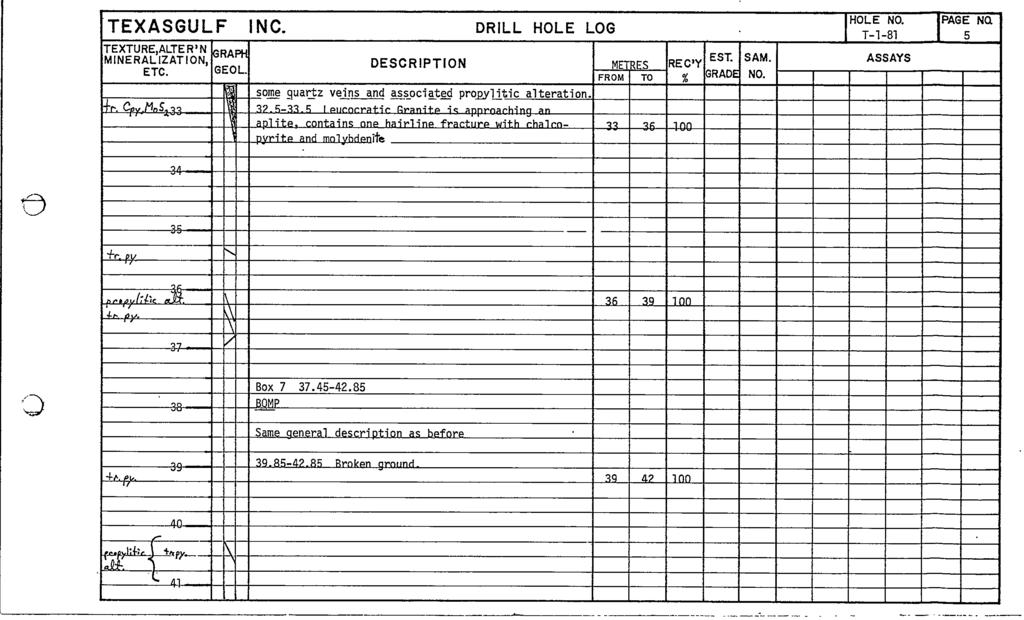
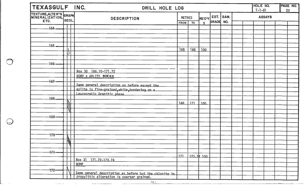
8 6 o units was located in August 1981 and is contiguous southern boundary of THOM 2 Figure 3 with the The original Molly Tom 1 to 8 were transferred by bill Df sale to Texasgulf Canada Ltd Subsequent claims were staked in that Company s name All claims are now owned by Kidd Creek Mines Ltd Transfer was by a legal change of Company name effective December 3D 1981 The claim ownership transfer was recorded in Vancouver on March Summary of Work Completed During the 1981 season Texasgulf Inc on behalf of Texasgulf Canada Ltd repaired the camp located a drill site and contracted the drilling of four NQ diamond drill holes totalling m Mineralized core was assayed for Cu and MOS2 All drilling was carried out on the Molly Tom 1 and Molly cj Tom 2 mineral claims Figure 3 GEOLOGY The geology of the property has been described in several company and government reports see Bibliography Molybdenite and lesser chalcopyrite occur within a quartz vein system along the northwestern contact of a 53 8 Ma old quartz monzonite stock cutting argillites of the Bowser Lake Group Figure 3 and 4 The mineralized zone is an irregular tabular zone up to 100 m wide and dips at approximately 600 to the northwest DIAMOND DRILLING The locations of the four diamond drill holes drilled from the same site are shown in Figure 4 D D H T 1 81 collared at 520 was abanddned at m because of bad ground conditidns o
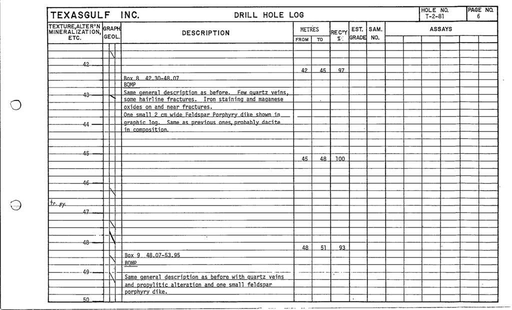
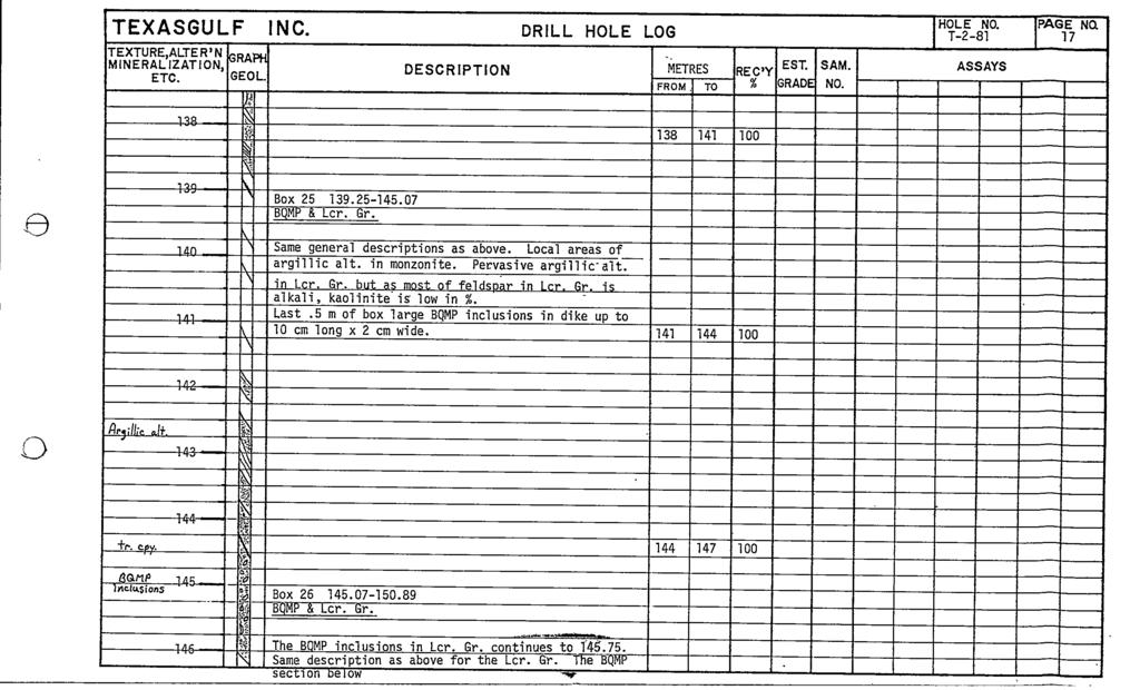
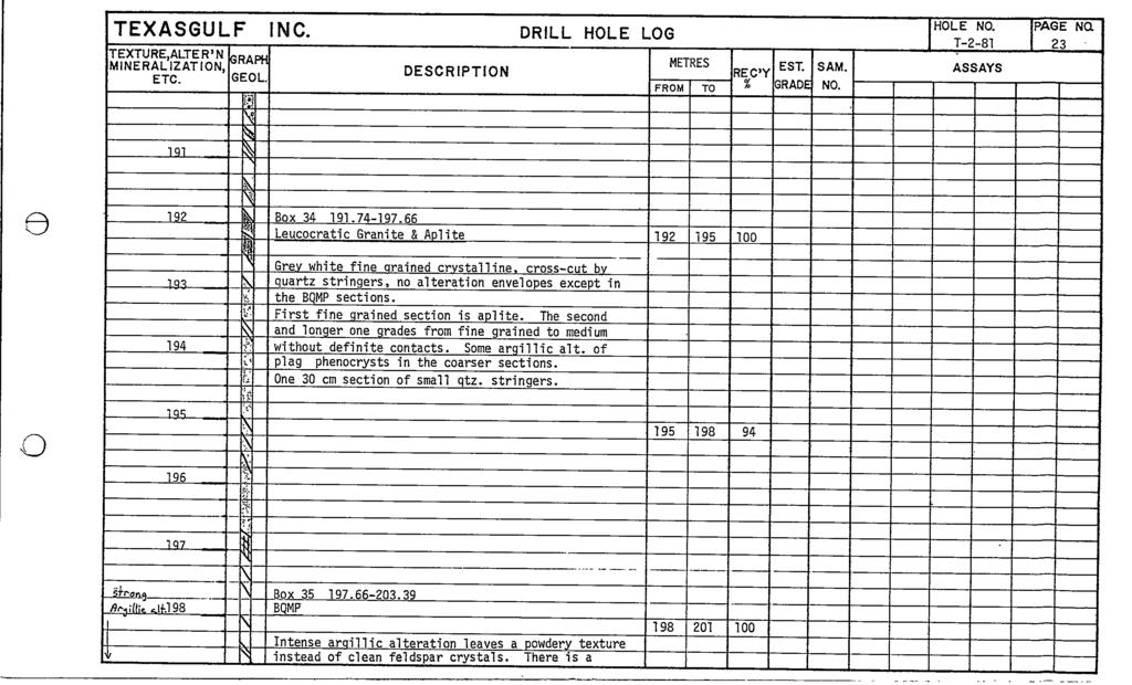
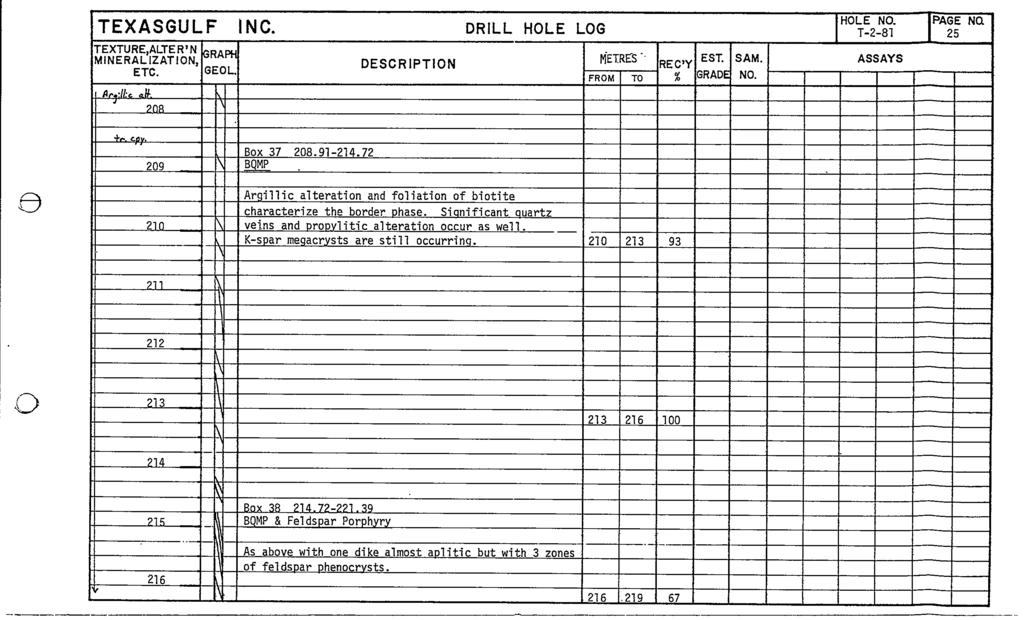
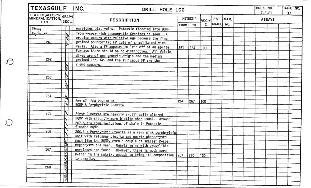
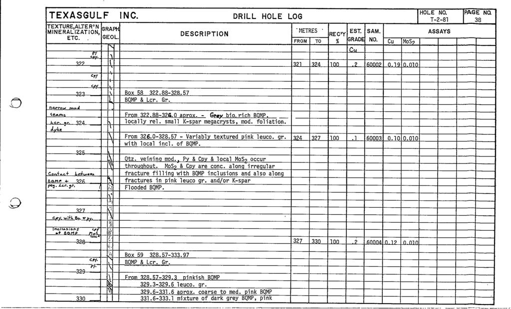
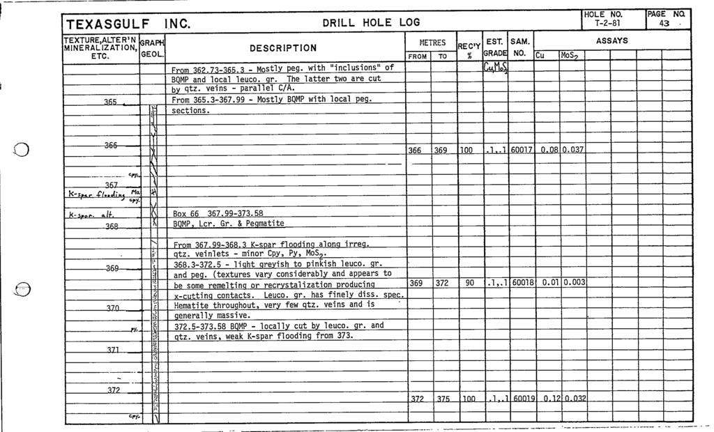
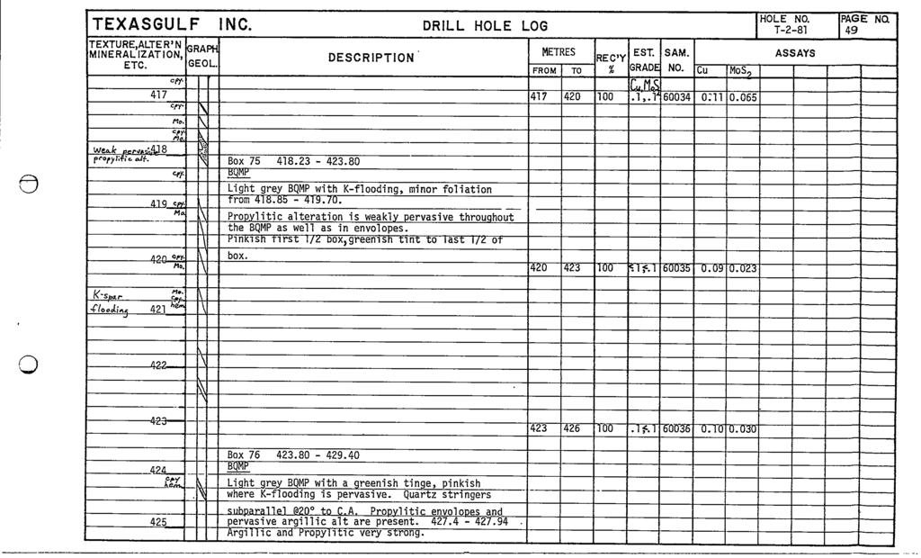
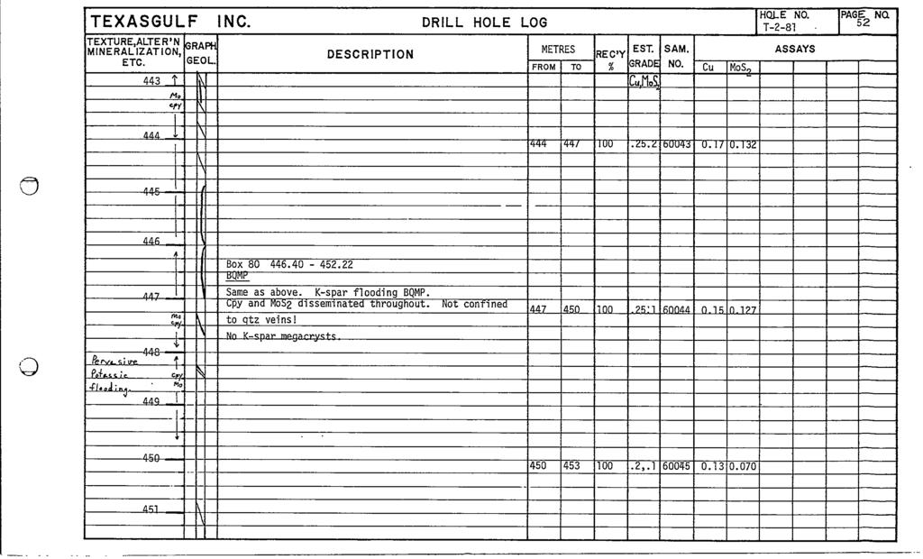
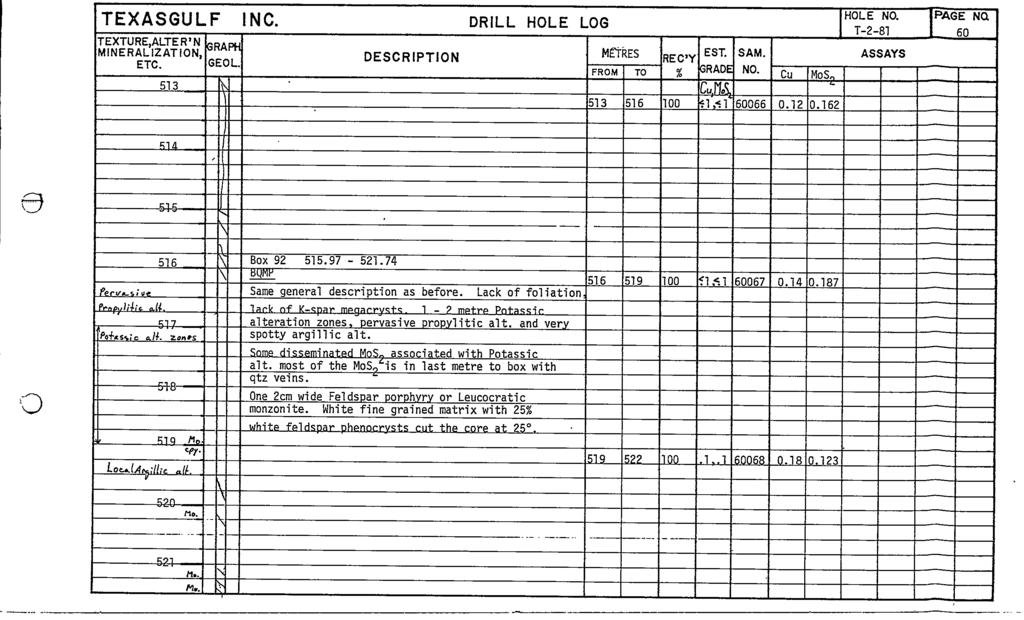
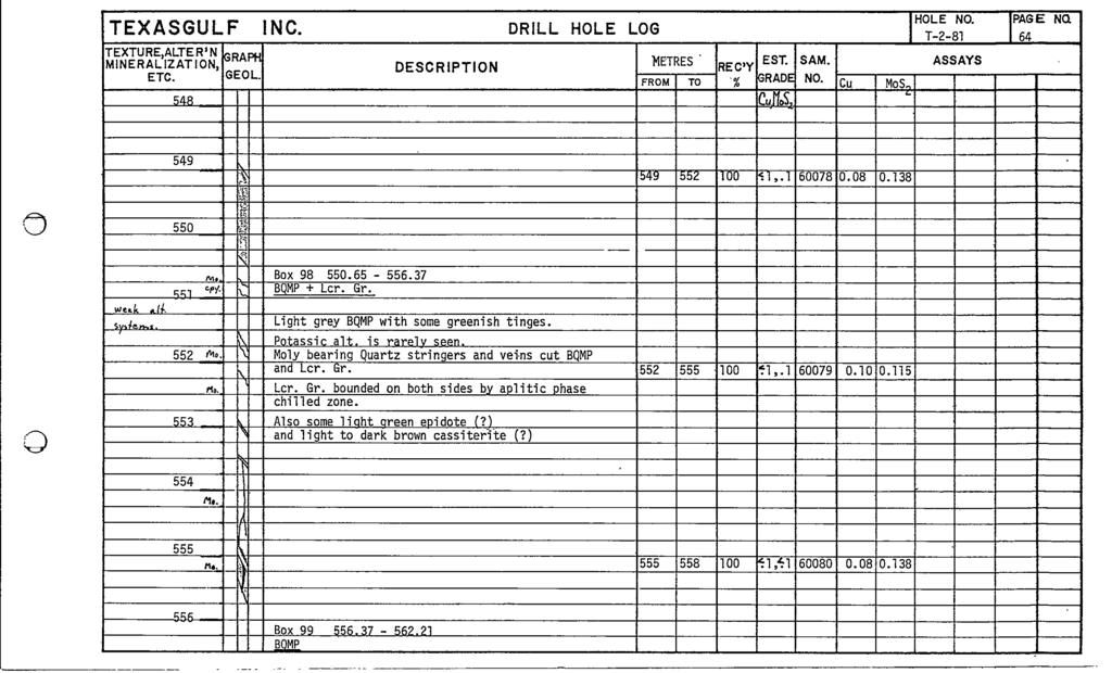
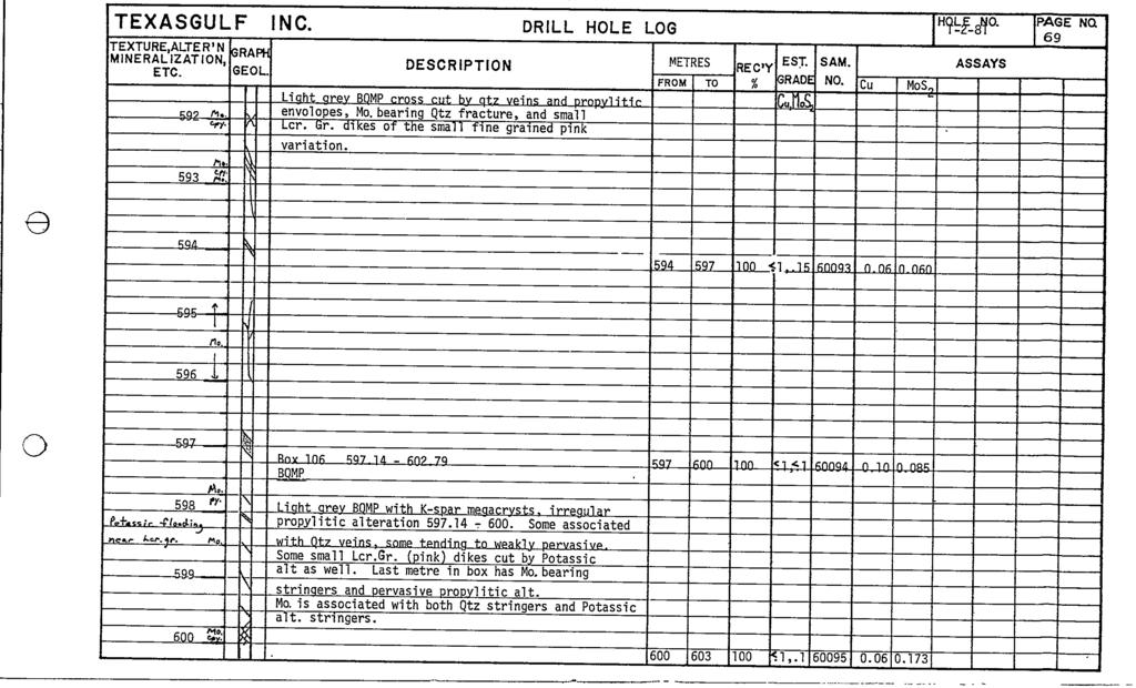
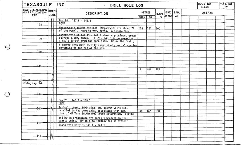
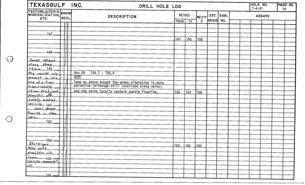
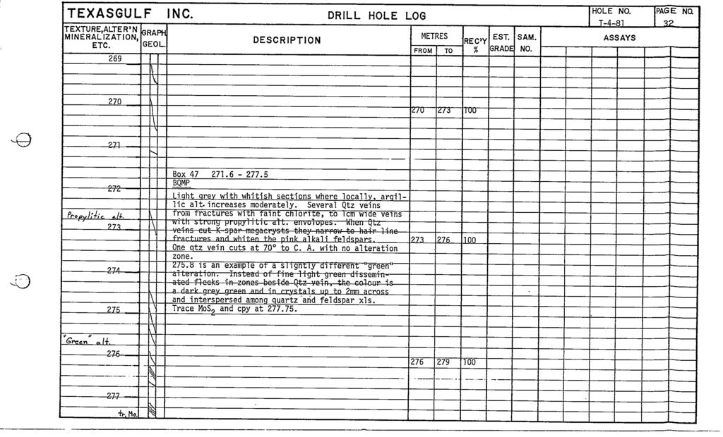
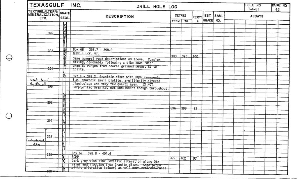
9 7 o T 2 81 collared at 450 intersected 357 m true thickness 78 7 m of MoSZ and 0 11 Cu and was stopped in the argillites at m T was abandoned at 87 5 m due to drilling difficulties T was stopped at m in the hanging wall shales no significant mineralization was encountered Mineralized core mostly from T 2 81 was split and 3 metre sections assayed for Cu and MoS2 Drill core logs are presented in Appendix B assay results are listed in Appendix C Thomlinson camp Core is stored at the Mt The intersection obtained in T 2 81 is not significantly better than intersections obtained by AMAX at higher levels within the zone No drilling is planned for 1982 o A f P R DeLancey P Eng If 1 1 o
10 8 o BIBLIOGRAPHY Bending D A 1981 Assessment Work Report Diamond Drilling Program August and September 1980 on claims Molly Tom 1 4 and 8 Omineca Mining Division B C Report submitted for assessment credit to the British Columbia Ministry of Energy Petroleum Resources March 1981 Mines and Carithers Ward 1965 Report on the Butt1e Lake Molybdenite Project Mount Thomlinson B C unpublished AMAX Company Report 15 pages DeLancey P R 1980 Geological Report of the Thorn Group Mount Thomlinson Omineca Mining Division unpublished Texasgu1f Company report 7 pages Kirkham R V 1964 B C Department of Mines and Petroleum Resources Report 1964 pp Loudon J R 1963 Butt1e Lake Molybdenite Prospect Supplemental Geological Report unpublished AUl Company Report 19 pages o Mannard G W and Sinclair A J 1964 Butt1e Lake MoSZ Project 1964 Unpublished AMAX Company Report 73 pages o
11 o APPENDIX A STATEMENT OF EXPENDITURES o o
12 I o STATEMENT OF THOM 82 GROUP EXPENDITURES SALARIES AND FRINGE BENEFITS TEXAS GULF INC G R Peatfield P Eng Period July 13 Aug P R DeLancey P Eng Period July 5 Aug G Cooper Geologist Period July 6 Sept R Lemery Assistant Period July 6 Aug C Aspeslet Expediter Period July 3 Sept T Eigeard Cook Period July 6 Sept J Etzkorn Cook Period Aug days ROOM AND Tg personnel Longyear personnel HELICOPTER SUPPORT Invoice totals Northern Mountain Helis Invoice totals Okanagan Helis Texasgulf leased A Star DIAMOND DRILLING Longyear Canada invoices for drilling wedging survey core boxes supplies and equipment moving mob and demob Rental of Sperry sun survey instrument c fwd
13 j o ANALYTICAL COSTS c fwd I I I ii I I I I I 161 MoS Cu REPORT PREPARATION G R Peatfield P Eng P R DeLancey P Eng Drafting Secretarial etc o MISCELLANEOUS Office technical supplies Pro rated share of travel Shipping and storage Communications radio etc bfq 1 03 o
14 o IPPENOl X C ASSAYS OF DIAMOND DRILL CORE o o
15 APPENDIX PROPERTY MT THOMLINSON HOLE rlo T 2 81 PAGE 1 of 5 C c LATITUDE LONGITUDE ELEVATION E59200 N6160BOO 1850 m AZIMUTH DIP IiICLINATION HICLINATION H1CLINATION at m at m at 79 7 m SA IPLE I ETRES f1os 110 JO W ClI No FR0 1 TO ASSAYS AVG oom ASSAYS AVG ppm ODm R 3 1 o nm O nlo n nn j o n h o j I I I Q I R7 n nrr I II I II IQI n OQn I Q n nn I 0 07 o I I I fl 411 o I n n n I O R I 414 A17 noli I o I
16 PROPERTY MT THOMLINSON HOLE iio T 2 81 PAGE L of L o LATITUDE AZ HIUTH IrICLINATION 1 at LONGITUDE DIP INCLINATION 1 at ELEVATION INCLINATION 1 at SANPLE letres lps Cu No FRON TO ASSAYS AVG oom t ASSAYS AVG oom nom nln I o n l07 n I O lfi O ll o f l n O lr I o n llt7 n 1R I o I 507 n la 0 15 o I 0 10 I fi1 511 n 1 n n 1117 I o 111 II 110 I n 1 l n 10 Q fi I I n noi n 1 l
17 PROPERTY MT THOMI TNSON HOLE No T ill PAGE L of 5 LATITUDE AZHIUTH INCLINATION 1 at LONGITUDE DIP INCLINATION 1 at o o ELEVATION INCLINATION I at SAt IPLE r 1ETRES lio No 10 I Cu No FROM TO ASSAYS AVG ppm ASSAYS AVG porn I I I ry pom I I I I 0 05 o I
18 i PROPERTY MT THOMLINSON HOLE No PAGE 4 of 5 LATITUDE LONG nude AZH 1UTH DIP INCLINATION 1 at INCLINATION I at o ELEVATION INCLINATION 1 at SA IPLE I1ETRES l Cu No FROt1 TO ASSAYS AVG DDm ASSAYS AVG oom opm I I I I onl n n n7 IlQ 11l n nlln II I 9 11l 1111 o nl7 n n Ill IlR n l17 n n7 1 AO 1 11 o na n nl n Oil O ln 5 I O 11 n lll n n I q n n7 n n7 8 IIQ li7 n 013 n f i 10 on ll n nl IIIA n 17 n lil7 n 19n n IQn nnql n Q 0 n nl Ii IOQ 70 0 n 7 OR 9 n no 702 7nl n nl I nll n nl n nl 1 7nll 711 n n7 n nl o 1n I on n nro 0 01 n nl O nl n nl o I O O 6 n 7 l 7 1 n nl no 7 n O n m n lnn n 9 7 7ll n n07 I n n l1 7l1l n nan n nil
19 I PROPERTY MT THOMLI NSON HOLE 110 T 2 81 PAGE 5 of L LATITUDE AZH1UTH INCLINATION I at LONGITUDE DIP INCLINATION 1 at o ELEVATION INCLI NATION I at SAMPLE ietres NoS 10 IO I eu J No FROM TO ASSAYS AVG oom ASSAYS AVG oom nnm I I Ii 7R1 7RI O OI R n n O OR o OIL I I o
20 PROPERTY MT THOMLINSON HOLE No T 4 81 PAGE Lof L c LATITUDE E59200 AZIMUTH 2650 INCLINATION i2at LONGITUDE N1660BOD DIP INCLINATION 57 JA2 256at ELEVATION 1850 INCLINATION A2 24a t SAf1PLE IETRES No W Cu MaS No WO FROM TO ASSAYS AVG DDm ASSAYS AVG DDm ppm I 1 I I I O O O O lq Oon o o I 1 1 I I I I I i oj I i

21

22

23
24

25
26

27

28

29

30

31

32

33

34

35

36

37

38
39
40

41

42

43

44

45
46
47

48

49

50

51

52

53

54

55

56
57

58

59

60

61

62
63

64
65

66

67

68

69

70
71

72

73

74

75

76

77
78

79

80

81

82
83

84

85

86

87

88
89

90

91
92

93

94

95

96

97

98

99
100

101

102

103
104

105

106

107

108
109

110

111

112

113

114

115

116

117

118

119

120

121

122

123

124

125

126

127

128
129

130

131

132

133

134

135

136

137
138
139

140

141
142

143

144

145

146

147

148

149

150
151

152

153

154

155
156
157

158

159

160

161

162

163

164

165

166

167

168

169

170
171

172

173

174

175

176

177

178

179

180

181

182

183

184
185

186

187

188

189

190
191

192

193

194

195

196

197
198

199

200

201

202

203

204

205

206

207

208

209
210
211
TABLE OF CONTENTS APPENDICES SUMMARY DRILL LOG STATEMENT OF QUALIFICATION STATEMENT OF EXPENDITURES LIST OF FIGURES
 ASSESSMENT WORK REPORT DIAMOND DRILLING PROGRAM AUGUST AND SEPTEMBER, 1980 ON CLAIMS Molly Tom 1-4 and 8 Omineca Mining Division NTS 93M/llU 55'35'N, 127"29'W by David A. Bending Owner: Operator: Texasgulf
7Yh THOM GROUP. Mt. 93M/11 W. .GEOLOGICAL REPORT on the. Thomlinson, Omineca Mining Division. Lat 55"35' Long 127'29' DeLancey, P.Eng. Peter Ft.
 .GEOLOGICAL REPORT on the Mt. THOM GROUP Thomlinson, Omineca Mining Division 93M/11 W Lat 55"35' Long 127'29' Peter Ft. by DeLancey, P.Eng.! Owner: Operator: Texasgul f Canada Ltd. Texasgulf Canada Ltd.
cpw 6. E. Spencer Engineering Ltd. HANNA 9 M. C. 104 REP 0 RT DIAMOND DRILLING PROGRAMME LIARD MINING DISTRICT, K.T.S. FOR TAURUS RESOURCES LTD.
 6. E. Spencer Engineering Ltd. LlJ REP 0 RT ON DAMOND DRLLNG PROGRAMME cpw HANNA 9 M. C. LARD MNNG DSTRCT, K.T.S. 104 P@g FOR TAURUS RESOURCES LTD. BY B. E. SPENCER, P. ENG. B. E. SPENCER ENGNEERNG LTD.
PHYSICAL WORK REPORT. the BAY CLAIMS. Omineca Mining Division Smithers, British Columbia N.T.S. 93E 13E/W
 PHYSICAL WORK REPORT the BAY CLAIMS Omineca Mining Division Smithers, British Columbia a N.T.S. 93E 13E/W LATITUDE: 53 57 00 N I LONGITUDE: 127 45 OO W for Home Ventures Ltd. 1201-675 West Hastings Street
GEOLOGICAL MAPPING REPORT ON THE ASH MINERAL CLAIM OSOYOOS MINING DIVISION ASHNOLA RIVER MAP SHEET NTS M092,H019 MCBRIDE CREEK AREA, ASHNOLA RIVER,
 GEOLOGICAL MAPPING REPORT ON THE ASH MINERAL CLAIM OSOYOOS MINING DIVISION ASHNOLA RIVER MAP SHEET NTS M092,H019 LATITUDE 49 o O6, LONGITUDE 120 o 22 MCBRIDE CREEK AREA, ASHNOLA RIVER, KEREMEOS, B.C. CANADA
on the SALAL CREEK MOLYBDENUM PROPERTY, SALAL CREEK, B.C. LILLOOET MINING DIVISION, BRITISH COLUMBIA
 on the J PLUG 9-12, PLUG 19-24, BAT 10-14, BAT 15 Fr., BAT 16 Fr. MINERAL CLAIMS, SALAL CREEK MOLYBDENUM PROPERTY, SALAL CREEK, B.C. LILLOOET MINING DIVISION, BRITISH COLUMBIA N.T.S. 92 J 14 LATITUDE 50
NEW HAZELTON, OMINECA M.D.,
 PROSPECTING REPORT JUDI 1 TO 6 MINERAL CLAIMS NEW HAZELTON, OMINECA M.D., B.C. MAP 93M/4E, LAT. SS014'N, LONG. 127'33'W OWNED BY: A. L'ORSA ANTHONY L'ORSA Smithers, B.C. 21 February, 1981 TABLE OF CONTENTS
GEOPHYSICAL REPORT. Airborne Magnetometer Survey. of the SHEEP-GOAT GROUP OF MINERAL CLAIMS. near Li l looet, B.C.
 GEOPHYSICAL REPORT 977 Airborne Magnetometer Survey of the SHEEP-GOAT GROUP OF MINERAL CLAIMS near Li l looet, B.C. Lillooet Mining Division (Lat.51 'lot Long. 122 40' 7 5t0[2L05E. for DUFFEY LAKES MINES
on the Diamond Drilling done on the LAKESIOE GROUP of Mineral Claims SLOCAN MINING DIVISION 82-F-14-W Long ' Lat '
 Assessment Work Report on the Diamond Drilling done on the LAKESIOE GROUP of Mineral Claims SLOCAN MINING DIVISION 82-F-14-W Long 117 22' Lat. 49 58' ADRIAN KESLER SILVERTON, B.C. operator LEVON RESOURCES
GEOLOGICAL MAPPING OF SKARNS ON THE SHEEP AND EWE CLAIMS, TURNAGAIN RIVER, B.C. DURING THE 1979 SUMMER SEASON
 GEOLOGICAL MAPPING OF SKARNS ON THE SHEEP AND EWE CLAIMS, TURNAGAIN RIVER, B.C. DURING THE 1979 SUMMER SEASON CLAIMS: Sheep 1 to 4 Ewe 1, 3, 4 to 8 Lamb 12 Fraction Liard Mining Division, B.C. NTS 104
SOIL GEOCHEMISTRY. OK-ll AND OK-Ill MINERAL CLAIMS MOUNT THOEN AREA OMINECA MINING DIVISION, B.C. NTS 93 MI6 E & 7 W
 SOIL GEOCHEMISTRY OK-ll AND OK-Ill MINERAL CLAIMS MOUNT THOEN AREA OMINECA MINING DIVISION, B.C. NTS 93 MI6 E & 7 W LATITUDE 55O23'N, LONGITUDE 127 01W Locke B. Goldsmith, P.Eng. Consulting Geologist December
R.A. COMINCO LTD. EXPLORATION NTS: 92H/16. WESTERN DISTRICT January 6, 1982 ASSESSMENT REPORT 1981 SOIL GEOCHEMISTRY ON THE TROUT PROPERTY
 COMINCO LTD. EXPLORATION NTS: 92H/16 WESTERN DISTRICT January 6, 1982 ASSESSMENT REPORT 1981 SOIL GEOCHEMISTRY ON THE TROUT PROPERTY (Trout 1 and 6 Claims) SIWASH LAKE AREA, SIMILKAMEEN M.D., B.C. (Work
A Report on a Magnetometer Survey. Division, British Columbia. Gypsy 1-32 and Gypsy 1 Fr-9 Fr. 27 miles north of Smithers
 - A Report on a Magnetometer Survey on the Gypsy Claims, Omineca Mining Division, British Columbia Covering: Gypsy 1-32 and Gypsy 1 Fr-9 Fr Located: 27 miles north of Smithers Latitude 55O11' N Longitude
OSOYOOS UINING DIVISION. 49% - 20' North Latitude 120% - 05' West Longitude. GOOD HOPE RESOURCES LTD West Hastings Street Vancouver, B. C.
 REPORT ON HORSEFLY PROPERTY DIAMOND DRILLING - 1982 OSOYOOS UINING DIVISION 49% - 20' North Latitude 120% - 05' West Longitude 9 x It/YG FOR GOOD HOPE RESOURCES LTD. 1518-1177 West Hastings Street Vancouver,
GEOPHYSICAL REPORT CHU CHUA PROJECT Green Mountain Group. KAMLOOPS MINING DIVISION NTS 92P/8E, 82M/5W Lat: 51'24' N Long: 120'00' w
 I GEOPHYSICAL REPORT CHU CHUA PROJECT Green Mountain Group KAMLOOPS MINING DIVISION NTS 92P/8E, 82M/5W Lat: 51'24' N Long: 120'00' w I rvm #.,_..._..._._._.- $...-...! 1 VANCOUVER, B.C. 1 G E 0 I, 0.G
REPORT. on the. Omineca Mining Division, British Columbia. Latitude N., Longitude W. NTS map sheet 93F/7E. James W. McLeod, P.Geo.
 REPORT on the CHU MOLYBDENUM PROPERTY Omineca Mining Division, British Columbia Latitude 53 21 N., Longitude 124 37 W. NTS map sheet 93F/7E James W. McLeod, P.Geo. on behalf of Mr. Chris Delorme TABLE
Lat. 52' 43' N Long ' W
 &A exploration ltd MINING ENGINEERING GEOLOGY- GEOPHYSICS 4570 HOSKINS ROAD, NORTH VANCOUVER, 6. C. TELEPHONE (804) 985,7921 V7K 2R1 GEOLOGICAL AND GEOCHEMICAL REPORT on the BLUE CLAIMS Cariboo Mining
%+ '$# $) %, %*$ " $ $ ' %' !()'-!" %( %"%! " *'+ - % %$! $)! " $)!" !$ ' "! )( ! $ '%& ')- % % "!#( (( ((# $) ' ) ((* & *# ' % %"*# ( !!
 %, %*$ $ $ ' %' !()'-! %( %%! *'+ - % %$! $)! $)! !$ ' ! )( ! $ '%& ')- % % !#( (( ((# $) ' ) ((* & *# ' % %*# ( !!") 001L/14/0218 First Year Assessment Report of Prospecting, Rock and Stream Sediment Sampling On Licence 18880M, NTS 1L/14 Burin Peninsula Newfoundland and Labrador Submitted by: Keith Kelloway Work year:
001L/14/0218 First Year Assessment Report of Prospecting, Rock and Stream Sediment Sampling On Licence 18880M, NTS 1L/14 Burin Peninsula Newfoundland and Labrador Submitted by: Keith Kelloway Work year:
UNION MINIERE EXPLORATIONS AND MINING CORPORATION LIMITED ASSESSMENT REPORT ON FITINAT MINERAL CLAIM. Alberni Mining Division Record No.
 M F )( UNION MINIERE EXPLORATIONS AND MINING CORPORATION LIMITED Suite 200, 4299 Canada Way, Burnaby, B.C. V5G 1 H4 Telephone (604) 437-9491 ASSESSMENT REPORT ON GEOCHEMICAL SOIL SURVEYS AND ROCKSAMPLING
DRILLING REPORT ON THE HIGHLAND VALLEY, KAMLOOPS MINING DIVISION, OWNED BY GAZA MINES LTD., NEW JERICHO DEVELOPMENT AND TECK CORPORATION
 DRILLING REPORT ON THE GAZA 1 AND JERICHO 1 AND 2 MINERAL CLAIMS / (RECORD NUMBERS 159, 492 AND 161) HIGHLAND VALLEY, KAMLOOPS MINING DIVISION, LATITUDE 50' 26' N; LONGITUDE 120' 55' W; NTS 92-I/7W OWNED
1 CLAIMS GEOPHYSICAL REPORT ON BOYAL SITUATE NORTHEAST OF TILLICUM MOUNTAIN GOLD AREA BURTON - NAKUSP SIQCAEJ MINING DIVISION
 GEOPHYSICAL REPORT ON BOYAL 1 CLAIMS SITUATE NORTHEAST OF TILLICUM MOUNTAIN GOLD AREA BURTON - NAKUSP SIQCAEJ MINING DIVISION CONSULTING GEOLOGIST AUGUST 1983 VANCOUVER B *C INDEX INTRODUCTION ooa,.eoaaa.aaaoaaooaoa~ao~o
HY LAKE GOLD INTERSECTS 1.0 METRES OF GRAMS PER TONNE GOLD FROM ROWAN PROPERTY ROWAN MINE SYSTEM STRIKE LENGTH EXTENDED TO MINIMUM 800m
 NES ELEASE CNSX: YL FANKFT: YK Y LAKE GOLD INTESECTS. METES OF 4.5 GAMS PE TONNE GOLD FOM OAN POPETY OAN MINE SYSTEM STIKE LENGT EXTENDED TO MINIMM 8m FO IMMEDIATE ELEASE, February 6, Toronto, Ontario.
ASSESSMENT' REPORT GEOPHYSICAL REPORT ON THE ATTORNEY 2 CLAIM (4 UNITS) OMINECA MINING DIVISION SHEILA A. CRAWFORD.
 OMINECA MINING DIVISION SHEILA A. CRAWFORD.") ASSESSMENT' REPORT GEOPHYSICAL REPORT ON THE ATTORNEY 2 CLAIM (4 UNITS) OMINECA MINING DIVISION by SHEILA A. CRAWFORD LOCATION: 57z17' N Latitude 127 11' W Longitude N.T.S. 94E/6E OWNER/OPERATOR: SEREM
ASSESSMENT' REPORT GEOPHYSICAL REPORT ON THE ATTORNEY 2 CLAIM (4 UNITS) OMINECA MINING DIVISION by SHEILA A. CRAWFORD LOCATION: 57z17' N Latitude 127 11' W Longitude N.T.S. 94E/6E OWNER/OPERATOR: SEREM
for the Greenwood Mining Division, B.C. NTS 82E/7W Latitude 49' 27' W, Longitude 118' 5 Prepared by a= D. Dylan Watt, B.Sc.
 t. b LOGnO: 37~ -08 m. ACTIO#: for the AMP AMP 2 AMP 3 t AMP 4 CLAIMS Greenwood Mining Division, B.C. NTS 82E/7W Latitude 49' 27' W, Longitude 8' 5 %E c,w zc *& a w Prepared by a= -4c. D. Dylan Watt, B.Sc.
t+o...&zz!. ASSESSMENT REPORT Department of Miner and Petroleum Resources MAP.,- INDUCED POLAKIZATION SURVEY OVER THE BROOKS PROSPECT
 5873 INDUCED POLAKIZATION SURVEY OVER THE BROOKS PROSPECT BROOKS PENINSULA AREA VANCOUVER ISLAND, B.C. NANAIMO AND ALBERNI MINING DIVISIONS BY Z. B. DOBORZYNSKI JANUARY, 1976 Department of Miner and Petroleum
Compilation Report Hawke Hill South. Licence No M NTS 01N/06. Newfoundland and Labrador. Submitted by Gordon E. Cooper and Kevin P.
 Compilation Report 2010 Hawke Hill South Licence No. 017282M NTS 01N/06 Newfoundland and Labrador Submitted by Gordon E. Cooper and Kevin P. Ryan For Kevin P. Ryan (Licence holder) January, 2011 Work Year:
PROSPECTING REPORT THE WALLACE CLAIM OMENICA MINING DIVISION. 54" x6" 3.d d. for. Reako Exlorat ions Ltd. Wallace Rev. C.G.
 PROSPECTING REPORT ON THE WALLACE CLAIM OMENICA MINING DIVISION 54"44 14 1x6" 3.d d by David A. Howard P.Eng. for Reako Exlorat ions Ltd. Claim Locat ion Wallace Rev. C.G. #1560 Dome Mountain Area 9 3
CONTENTS. Location, Access and History...6. Tenure Status and Geology Regional Andy Property Geology Map...9
 TYPE OFWORK IN THIS REPORT EXTENT OF WORK (rn METRTC UNITS) ON WHICH CLAIMS PROJECT COSTS APPORTIONED (incl. support) GEOLOGICAL (scale, area) Ground, mapping Photo interpretation GEOPHYSICAL (line-kilometres)
DIAMOND DRILL REPORT ON THE LOCATED IN THE OMINECA MINING DIVISION FAWNIE NOSE AREA LATITUDE: 53O 17' LONGITUDE: 125O 10' NTS 93F 6E
 GRANGES EXPLORATION AB CANADIAN DIVISION DIAMOND DRILL REPORT ON THE G, H and I CLAIM BLOCKS LOCATED IN THE OMINECA MINING DIVISION FAWNIE NOSE AREA LATITUDE: 53O 17' LONGITUDE: 125O 10' NTS 93F 6E. -.
2013 GEOLOGICAL ASSESSMENT REPORT SHERIDAN HILL PROPERTY
 2013 GEOLOGICAL ASSESSMENT REPORT ON THE SHERIDAN HILL PROPERTY NEW WESTMINSTER MINING DIVISION BRITISH COLUMBIA NTS 092G07 49 16 31 NORTH LATITUDE, 122 39 48 WEST LONGITUDE PREPARED FOR Sheridan Hill
PROSPECTORS ASSISTANCE PROGRAM MINISTRY OF ENERGY AND MINES
 BRITISH COLUMBIA PROSPECTORS ASSISTANCE PROGRAM MINISTRY OF ENERGY AND MINES GEOLOGICAL SURVEY BRANCH PROGRAM YEAR: 1999/2000 REPORT #: PAP 99-l 6 NAME: KIM ANSCHETZ PROSPECTORS TlEPORT on the 99 LOUIS
for the Greenwood Mining Division, B.C. NTS 82E/7W 29' W, Longitude 118' 53' N Prepared by D. Dylan Watt, B.Sc.
 for the FltE NO: u VOLT 1, VOLT 2, VOLT 3, & VOLT 4 CLAIMS Greenwood Mining Division, B.C. NTS 82E/7W Latitude 49' 29' W, Longitude 118' 53' N Prepared by D. Dylan Watt, B.Sc. #309-1996 Trutch Street Vancouver,
FIRST YEAR ASSESSMENT REPORT PROSPECTING LICENCE 16512M MARYSTOWN AREA, BURIN PENINSULA NTS 1M/3
 FIRST YEAR ASSESSMENT REPORT OF PROSPECTING ON LICENCE 16512M MARYSTOWN AREA, BURIN PENINSULA NTS 1M/3 BY NATHANIEL NOEL MSc. FOR E. MICHELE NOEL MINERAL LICENCES: 16512 M WORK CONDUCTED: MID-SEPTEMBER
Serengeti Resources Inc GEOCHEMICAL REPORT ON THE SHADOW PROPERTY a.
 Serengeti Resources Inc. 2004 GEOCHEMICAL REPORT ON THE SHADOW PROPERTY a. Located in the Johanson Lake Area Omenica Mining Division NTS 94D/9 6 degrees and 32 minutes North Latitude 126 degrees and 2
1 FILMED 1. FILE NO:!..rsrru -* -. GRAND TWO CLAIM
 FILE NO:!..rsrru -* -. GRAND TWO CLAIM REPORT ON 1993 ASSESSMENT WORK GRAND TWO CLAIM REC. NO. 301849 NELSON MINING DIVISION NTS MAP SHEET 82F6/W 49 25'51" NORTH 117 18'08" WEST 1 FILMED 1 AUTHOR: R. Jordan,
ASSESSMENT REPORT I.P./RESISTIVITY AND MAGNETICS SURVEY ON THE HAUTETE PROPERTY LATITUDE: 55O 12' N LONGITUDE: 126O 07' W
 NTS: 93W1 ASSESSMENT REPORT I.P./RESISTIVITY AND MAGNETICS SURVEY ON THE HAUTETE PROPERTY LATITUDE: 55O 12' N LONGITUDE: 126O 07' W OMINECA MINING DISTRICI'. B.C. CLAIMS COVERED : TET 1-8 TIME PERIOD:
T'he Horn property comprises a group of forty. contiguous claims owned by Canadian Superior Exploration
 -1- INTRODUCTION T'he Horn property comprises a group of forty contiguous claims owned by Canadian Superior Exploration Limited. The group is located five miles nort'h of Motase Lake. In July and August,
Prospecting Report 'S Office i DB Property, B.C. -J Negro Creek Nelson Mining District NTS 82F.050. Operator: Kootenay Gold Inc.
 . '.' I"' i9 12 Prospecting Report 'S Office i DB Property, B.C. -J Negro Creek Nelson Mining District NTS 82F.050 Operator: Kootenay Gold Inc. Owner: Darlene Lavoie Work Performed Summer of 2007 Report
ASSESSMENT REPORT ON THE PEAVINE PROJECT. DGW & Associates # Alberni Street, Vancouver, British Columbia, V6E 4V2
 ASSESSMENT REPORT ON THE PEAVINE PROJECT KAMLOOPS MINING DIVISION BRITISH COLUMBIA NTS 082M 12 Latitude 51 36' 19.0"North -- Longitude --119 47' 27.0"West UTM Zone 11, NAD 83 5720827N 306744E Prepared
lat ' N Long ' W
 305 7 ec1;, REPORT ON THE JERY CLAIMS OF POLA RESOURCES LTD. NTS 93L/16 0 0 lat. 54 45' N Long. 126 22' W BABIXE LAKE AREA OMINECA MINING DIVISION, B.C. PAUL PLICKA CONSULTING GEOLOGIST DECEMBER 30, 1981
The MAPLE BAY PROJECT Copper Silver - Gold
 The MAPLE BAY PROJECT Copper Silver - Gold Good grade and tonnage potential within close proximity to Tidewater The Maple Bay Copper Silver Gold Project covers highly favourable geological host rocks of
Summary of Rover Metals Geologic Mapping Program at the Up Town Gold Project, Northwest Territories
 October 13, 2017 Summary of Rover Metals Geologic Mapping Program at the Up Town Gold Project, Northwest Territories Vancouver, British Columbia, Canada - Rover Metals Corp., Rover, is pleased to provide
REPORT SOIL GEOCHEMICAL SURVEY. ATTYCELLEY NO. 2 GROUP (Attycelley Mineral Claims No. 7-10)
") REPORT SOIL GEOCHEMICAL SURVEY ATTYCELLEY NO. 2 GROUP (Attycelley Mineral Claims No. 7-10) Situated 7 miles east of north end of Thutade Lake, Omineca Mining Division British Columbia I Department of I
REPORT SOIL GEOCHEMICAL SURVEY ATTYCELLEY NO. 2 GROUP (Attycelley Mineral Claims No. 7-10) Situated 7 miles east of north end of Thutade Lake, Omineca Mining Division British Columbia I Department of I
ON THE LOST GOLD PROPERTY
 ON THE LOST GOLD PROPERTY NELSON MINING DIVISION BRITISH COLUMBIA Latitude: 49 18 North Longitude: 117 29.West TRIM MAPS: 82F1023,033 NTS: 8tF/5,6 By: Fred Critchlow . TABLE OF CONTENTS r PAGE lutroduction
---.,- A.S. ASH'TON, P. ENG. Delta, B.C. REPORT AMORE GROUP VICTORIA MINING DIVISION 32 KM S.S.W. OF NANAIMO, B.C. N.T.S.
 REPORT ON AMORE GROUP VICTORIA MINING DIVISION 32 KM S.S.W. OF NANAIMO, B.C. LATITUDE 48O57' N LONGITUDE 124O18' W N.T.S. 92C/16 W FOR AQUARIUS RESOURCES LTD. 11450-124 Street, Edmonton, Alberta. T5M OK3
GEOLOGICAL BRANCH ASSESSMENT REPORT 12. FItE NO: ACTION: THE GOLDEN MINING DIVISION, GOLDEN, Including THE NTS MAP; M82K/15W
 ACTION: FItE NO: Including 1990 GEO-CHEM SURVEY RESULTS -- THE AVD CLAIMS - THE GOLDEN MINING DIVISION, GOLDEN, B.C. NTS MAP; M82K/15W Lat. 50 deg. 55 Min. Long 116 deg. 55 min. For GEOLOGICAL BRANCH ASSESSMENT
BALFOUR MINING LTD. (N.P.L.) HAM GROUP 92-P-6, CLINTON M. D.8 B. C. Lat 51 17'N, GEOCHEMICAL REPORT. V. CUKOR, P. Eng.
 HAM GROUP 92-P-6, CLINTON M. D.8 B. C. Lat 51 17'N, GEOCHEMICAL REPORT. V. CUKOR, P. Eng.") 34q '7 BALFOUR MINING LTD. (N.P.L.) HAM GROUP 92-P-6, CLINTON M. D.8 B. C. Lat 51 17'N, Long 12lo14'W GEOCHEMICAL REPORT, V. CUKOR, P. Eng. January 31, 1972 TABLE OF CONTENTS 1. INTRODUCTION 2. PROPERTY,
34q '7 BALFOUR MINING LTD. (N.P.L.) HAM GROUP 92-P-6, CLINTON M. D.8 B. C. Lat 51 17'N, Long 12lo14'W GEOCHEMICAL REPORT, V. CUKOR, P. Eng. January 31, 1972 TABLE OF CONTENTS 1. INTRODUCTION 2. PROPERTY,
ASSESSMENT REPORT. Geochemical and Geological Surveys. on the. Gooch#1-4. Mineral Claims. Omenica Mining District NTS 93L/7W
 f- GEOLOGICAL BRANCH ASSESSMENT REPORT ASSESSMENT REPORT Geochemical and Geological Surveys on the Gooch#1-4 Mineral Claims Omenica Mining District NTS 93L/7W LAT: 54O25'W LONG: 126O26'W Operator: SMD
Reconnaissance. Of the. Denis mineral claims. Situated at Kilometer 844 of the Alaska Highway. Liard Mining Division. Northeastern British Columbia
 Reconnaissance Of the Denis mineral claims Situated at Kilometer 844 of the Alaska Highway Liard Mining Division Northeastern British Columbia N.T.S. 94M.075 Latitude 59 42 25 Longitude 127 13 12 Field
41,a* h0.iiii*bll*i2l,i DEADWOOD CREEK. for. James R. on the BOMBINI GROUP OF CLAIMS. GREENWOOD, British Columbia. Lat. 49'07' Long. 118'43 f.
 GEOLOGCAL REPORT on the BOMBN GROUP OF CLAMS DEADWOOD CREEK GREENWOOD, British Columbia Lat. 49'07' Long. 118'43 f in the GREENWOOD MNNG DVSON for FURY EXPLORATONS LTD. (N. P. L. ) Vancouver, B. C. December
DIANOND DRILLING REPORT. NICOLA MINING DIVISION, B.C. Lat 'N, Long. 12O03O'W N.T.S. Map 921/1 W82E. for
 W DIANOND DRILLING REPORT MM #1, MM #2, MM #3, INEZ #1, INEZ #2, AND CROWN GRANTED CLAIMS NICOLA MINING DIVISION, B.C. Lat. 50 10'N, Long. 12O03O'W N.T.S. Map 921/1 W82E for FLAIR RESOURCES LTD. 1417-409
Structural Analysis Using Hillshade Imagery. on the. LLC Property
 Structural Analysis Using Hillshade Imagery on the LLC Property Liard Mining Division NTS 104F/16W Latitude: 57 53' 47'' N Longitude: 132 03' 06'' W Owner Garry John Payie 3714 Raymond Street South, Victoria,
A GUIDE TO WRITING AN ASSESSMENT REPORT ON YOUR CLAIMS
 A GUIDE TO WRITING AN ASSESSMENT REPORT ON YOUR CLAIMS PLEASE NOTE! In the following pages, suggestions and advice are in italics, under each heading. Use as a guideline only. Items in bold should be changed
Geochemical Assessment Report. on the. Situated Nineteen Kilometres rth-northeast of Hope, B. C. in the. New Westminster Mining Division
 7 I Geochemical Assessment Report r on the r- I 1 Norm 1 to Norm 4 Mineral Claims c - I - 7 Situated Nineteen Kilometres rth-northeast of Hope, B. C. in the New Westminster Mining Division itude 49*32'N.,
SIMUKU DRILLING TO OVER 1000 METRES DEMONSTRATES SIGNIFICANTLY INCREASED TONNAGE POTENTIAL OF THE INFERRED RESOURCE
 ADDRESS PHONE PO Box 6965 +61(07) 5592 1001 Gold Coast Mail Centre FAX Qld 9726 Australia +61 (07) 5592 1011 EMAIL ABN 54 126 490 855 info@coppermoly.com.au WEBSITE www.coppermoly.com.au ASX Announcement
W. 1.NELSON Jr. P. ENG.
 GEOCHEMICAL AND GEOPHYSICAL SURVEY SNO GROUP CLAIMS W. 1.NELSON Jr. P. ENG. NORANDA EXPLORATION COMPANY, LIMITED OMINECA MINING DIVISION AUG. 17, 1971 - AUG. 29, 1971 TABLE OF CONTENTS - Page INTRODUCTION
Gold Mountain Group Gold Mtn. A, B, C & D Mineral Claims Record Nos. 697, 698, 699 & 700. Island Mountain Cariboo Mining Division British Columbia
 GOLD POINT RESOURCES LTD. Geophysical Survey Gold Mountain Group Gold Mtn. A, B, C & D Mineral Claims Record Nos. 697, 698, 699 & 700 Island Mountain Cariboo Mining Division British Columbia Vancouver,
zccaw- d 4, I SUB- RECORDER 1 GEOLOGICAL IBIRANC)~ SEP ASSESSMENT REPORT FRENO: ACTION: 2[-;tc,u,eAAA RECEIVED M.R.#... $... VANCOUVER, B.C.
~ SEP ASSESSMENT REPORT FRENO: ACTION: 2[-;tc,u,eAAA RECEIVED M.R.#... $... VANCOUVER, B.C.") c ON THE LOGMI: /+dq(. m. BONBON MINERAL CLAIM ' ACTION: 2[-;tc,u,eAAA -- FRENO: h zccaw- d 4, FOR LUCIA SPECOGNA I SUB- RECORDER 1 RECEIVED SEP 25 1990 M.R.#... $... VANCOUVER, B.C. i BY MARINO SPECOGNA
c ON THE LOGMI: /+dq(. m. BONBON MINERAL CLAIM ' ACTION: 2[-;tc,u,eAAA -- FRENO: h zccaw- d 4, FOR LUCIA SPECOGNA I SUB- RECORDER 1 RECEIVED SEP 25 1990 M.R.#... $... VANCOUVER, B.C. i BY MARINO SPECOGNA
GEOLOGICAL BRANCH ASSESSMENT REPORT
 GEOLOGICAL BRANCH ASSESSMENT REPORT REPORT ON GEOPHYSICAL GROUND SURVEYS ON THE CHILI CLAIM MAGNETIC, VLF DIP ANGLE ELECTROMAGNETIC, AND VLF RESISTIVITY SURVEYS BY HI LIMION SEPTEMBER 12, 1986 &! FILMED
LH Property Update: Magnum Goldcorp Hits High Grade Gold 16.9 m of g/t, including 10.9 m of g/t, and as well, 11 m of 20.
 Trading symbol: TSX-V: IBC News Release No. 15-04 2489 BELLEVUE AVENUE WEST VANCOUVER, BC V7V 1E1 TEL 604 922 2030 FAX 604 922 2037 TOLL FREE (CANADA) 1 888 888 9122 TOLL FREE (USA) 1 888 888 9123 LH Property
HOWE COPPER MINE PROJECT HIGH GRADE Cu-Ag with Au
 HOWE COPPER MINE PROJECT HIGH GRADE Cu-Ag with Au The Howe Copper Mine property is located approximately 55 kilometres northwest of Vancouver, BC. It is situated at 1431 metres elevation on the eastern
32?un North of Hope, B.C.,
 Geological Reconnaissance Assessment Report on portions of the Gilt Creek Group (Mike, C.G., Julie, and Gilt Mineral Claims) Situated 32?un North of Hope, B.C., New Westminster Mining Division N 'P 97H/11W
GEOPHYSICAL REPORT THE CAVZ CLAIMS
 GEOPHYSICAL REPORT Magnetometer Survey on THE CAVZ CLAIMS CAVZ M.C.'s 1 to 12, 15 to 26, 29 to 40, 45 to 54 Trail Peak, Omineca M.D. 13 miles northeast of Fort Babine 550 ) 126 S.E. by G.Podolsky J.Russell
compietea since tnat date, and wnicn comprisea btage I ot tne recommended
 compietea since tnat date, and wnicn comprisea btage I ot tne recommended four-stage program. GEOLOGY & MINERALIZATION The property situate6 on the southeast slope of Nickel Plate Mtn., and within the
COPPERSTONE RESOURCES AB INTERCEPTS ZONE OF CHALCOPYRITE-ARSENOPYRITE- BORNITE MINERALIZATION AT SVARTLIDEN IN FIRST DEEP DRILLHOLE FROM 720m-810m
 COPPERSTONE RESOURCES AB INTERCEPTS ZONE OF CHALCOPYRITE-ARSENOPYRITE- BORNITE MINERALIZATION AT SVARTLIDEN IN FIRST DEEP DRILLHOLE FROM 720m-810m In mid-january 2017 Copperstone Resource published a geological
CANEX. PLACEE LIMITE-D
 P- CANEX. PLACEE LIMITE-D EhTDA KO MINES D IWSI OiV PHONE: FRASER LA'KE 699-6211 ENDAKO, B.C. CANADA VOJ ILO PERCUSSION DRILLING REPORT FOR NU. 2 GROUP OF MINERAL CLAINS CANEX PLACER LIMITED ENDAKO MINES
GROAT CREEK CLAIMS (CANYON, GULLY PLATEAU GROUPS)
") GEOLOGICAL and GEOPHYSICAL SURVEYS & SUPPORTING WORK by D.A. G.R. Donnelly - B.Sc. Peatfield - P,Eng. & W.A. Gasteiger - Geophysicist on the GROAT CREEK CLAIMS (CANYON, GULLY PLATEAU GROUPS) situated west
GEOLOGICAL and GEOPHYSICAL SURVEYS & SUPPORTING WORK by D.A. G.R. Donnelly - B.Sc. Peatfield - P,Eng. & W.A. Gasteiger - Geophysicist on the GROAT CREEK CLAIMS (CANYON, GULLY PLATEAU GROUPS) situated west
High Grade Gold Drill Results Extend Buccaneer
 ASX ANNOUNCEMENT / MEDIA RELEASE ASX:ABU 14 June, 2012 High Grade Gold Drill Results Extend 31 metres averaging 3.68g/t gold including 14 metres averaging 7.56g/t gold ABM Resources NL ( ABM or The Company
EXPLORATION and DEVELOPMENT REPORT. Conrad Creek. PLACER and MINERAL CLAIMS SOUTHEAST BRITISH COLUMBIA
 EXPLORATION and DEVELOPMENT REPORT on Conrad Creek PLACER and MINERAL CLAIMS in SOUTHEAST BRITISH COLUMBIA Ed Friesen, BSc.E.E., P. Eng 8 Lake Placid Rise SE Calgary, Alberta T2J 5B5 April 2009 1 P age
490 20' 30" North Latitude ' 30" West Longitude
 _._.. I CONSULTING GEOLOGISTS 605-602 WEST HASTINGS STREET, VANCOUVER, B.C. V6B 1P2 TELEPHONE: (604) 689-5533 6 I F: ASSESSMENT REPORT ON THE PATSY 1 MINERAL CLAIM ' '?%2% I WHISTLE CREEK, HEDLEY ARE L-l-
SECOND and THIRD YEAR ASSESSMENT REPORT PROSPECTING LICENCE M, ROCK CUT PROPERTY, NTS 1N/12, NEWFOUNDLAND. ROY FRENCH (licence holder )
") SECOND and THIRD YEAR ASSESSMENT REPORT Of PROSPECTING On LICENCE 013704M, ROCK CUT PROPERTY, NTS 1N/12, NEWFOUNDLAND. By ROY FRENCH (licence holder ) Work Conducted: Sept. 17, 2008 Nov. 03, 2009 Total
SECOND and THIRD YEAR ASSESSMENT REPORT Of PROSPECTING On LICENCE 013704M, ROCK CUT PROPERTY, NTS 1N/12, NEWFOUNDLAND. By ROY FRENCH (licence holder ) Work Conducted: Sept. 17, 2008 Nov. 03, 2009 Total
UNION MINIERE EXPLORATIONS AND MINING CORPORATION LIMITED 1 GROUP OF MINERAL CLAIMS. Liard Mining Division, British Columbia
 UNION MINIERE EXPLORATIONS AND MINING CORPORATION LIMITED SUITE 200-4299 CANADA WAY BURNABY. RC. V5G 1 H4 TELEPHONE 437-949 1 - Z ASSESSMENT REPORT ON DIAMOND DRILLING ON THE CLAW NO. 1 GROUP OF MINERAL
Daiwan Engineering Ltd Granville strees V.ncouver, B. C. cuudr WY 1GS. M e : (604) PROSPECTING REPORT ON THE KING MINERAL CLAIMS
 PROSPECTING REPORT ON THE KING MINERAL CLAIMS") 1030-609 Granville strees V.ncouver, B. C. cuudr WY 1GS M e : (604) 688-1508 PROSPECTING REPORT ON THE KING MINERAL CLAIMS NORTH VANCOUVER ISLAND, BRITISH COLUMBIA NTS: 92Lj13E Latitude: 50" 47' Longitude:
1030-609 Granville strees V.ncouver, B. C. cuudr WY 1GS M e : (604) 688-1508 PROSPECTING REPORT ON THE KING MINERAL CLAIMS NORTH VANCOUVER ISLAND, BRITISH COLUMBIA NTS: 92Lj13E Latitude: 50" 47' Longitude:
Mines and,3efro!sgrn Resources
 on the JO ANN MINERAL C LAIMS 35 Miles Northwest of Germansen Landing, B.C. Omineca Mining Division British Columbia MineralClaimMap 93N/13E, 14W Latitude: 55O 57' Longitude: 125O 28' by Douglas Stelling,
Pacific Empire Minerals Provides Copper King RC Drilling Results
 Pacific Empire Minerals Provides Copper King RC Drilling Results November 1, 2018 - Vancouver, BC, Canada - Pacific Empire Minerals Corp. (TSXV: PEMC) ( Pacific Empire, PEMC or the Company ), a hybrid
SUMMl'l WlLS LIU. GEOPHYSICAL REPORT. W. CT. a~evenson Y I
 SUMMl'l WlLS LIU. GEOPHYSICAL REPORT W. CT. a~evenson Y3 qi@, 1970. I 2-90 9 CONTENTS - PAGE Introduction... 1 Property... 1 Location and Access... 1 Survey Specifications Survey Grid... 1 Induced Polarization
58 l'gr'n 'E. Date: January 23, 1979 ASSESSMENT REPORT PLACER SAMPLING & JADE BOULDER EVALUATION PLACER LEASE Liard Mining Divison 1041/7E
 ASSESSMENT REPORT PLACER SAMPLING & JADE BOULDER EVALUATION PLACER LEASE 1711 Liard Mining Divison 1041/7E 58 l'gr'n 18 38'E Owner & operator: Cry Lake Jade Mines Ltd. Author: A.M. Homenuke, P.Eng. Date:
GEOCHEMICAL REPORT THE 82M/12 FH GROUP BIRCH ISLAND, B.C. S1 119O NOW. ROYAL CANADIAN VENTUR 3S LTD. By: Vollo, P. Eng. N.B. Pay 28th, 1969.
 c GEOCHEMICAL REPORT ON THE 82M/12 FH GROUP AT BIRCH ISLAND, BC S1 119O NOW BY ROYAL CANADIAN VENTUR 3S LTD NB By: Vollo, P Eng Pay 28th, 1969 Approximately 700 samples were collected over 14 miles of
7 miles West of Kamloops, B.C.
 MINERAL RESOURCES BRANCH ASSEWAENT RiPORT of hole # 78-11 NO. drilled on the ZZ # 18 Claim of China Commercial Corporation Ltd situated 7 miles West of Kamloops, B.C. in the Kamloops Mining Division D.R.
Dspartrnesrf of ASSESSMENT REPORT AEROMAGNETIC SURVEY BY CLAIM GROUP RACING RIVER AREA LIARD M.D., B.C. 9.1 K/II d
 Dspartrnesrf of r Mines and Petroleum Resources ASSESSMENT REPORT I NO., 2-k...+.A...,.. MAP...,...,...,...,.,.,...,.,.,, AEROMAGNETIC SURVEY TANJO MINES LTD. (N.P.L.) BY CLAIM GROUP RACING RIVER AREA
PRECIOUS METALS. owner. JMT Services Corp. GEOCHPlICAL SAMPLING CHELASLIE WCE, NORTH CENTRAL, B.C. OMINECA MINING DIVISION NTS 93F/5E & 6W
 PRECIOUS METALS REPORT ON 1980 RECONNAISSANCE GEOCHPlICAL SAMPLING CHELASLIE WCE, NORTH CENTRAL, B.C. OMINECA MINING DIVISION NTS 93F/5E & 6W LATITUDE 53O28 N LONGITUDE 125O31 W DATES Qp WORK: JULY 10
NTS 93L/9W GEOCHEMICAL AND GEOPHYSICAL REPORT MONA CLAIM OMINICA MINING DIVISION. Lati tude 54036'N; Longitude 'W
 GEOCHEMICAL AND GEOPHYSICAL REPORT ON MONA CLAIM OMINICA MINING DIVISION Lati tude 54036'N; Longitude 126018'W NTS 93L/9W April 1981 Paul Plicka Consulting Geologist LOCATION MAP INTRODUCTION TABLE OF
BRITISH NEWFOUNDLAND EXPLORATION LIMITED PROSPECTING REPORT JR AND MARK CLAIMS LIARD MINING DIVISION, B. C. By: Michael G.
 BRITISH NEWFOUNDLAND EXPLORATION LIMITED PROSPECTING REPORT JR AND MARK CLAIMS LIARD MINING DIVISION, B. C. By: Michael G. Willia 6- "t f I - -- ---- --.--. Department af I Brinex Report No. ~74546,- NTS
News Release February 27, 2014 TSX SYMBOL: COP
 Suite 1280 625 Howe St Vancouver, B.C. V6C 2T6 February 27, 2014 TSX SYMBOL: COP www.coromining.com CORO ANNOUNCES DRILLING RESULTS FROM ITS EL DESESPERADO PROJECT, CHILE February 27 2014, Coro Mining
AND HORSEFLY PROSPECTS, N.W. BRITISH COLUMBIA NTS, 103H/ll, 14 FOR ATNA RESOURCES LTD DELTA GEOSCIENCE LTD
 AND HORSEFLY PROSPECTS, N.W. BRITISH COLUMBIA NTS, 103H/ll, 14 FOR ATNA RESOURCES LTD BY DELTA GEOSCIENCE LTD FE T A. HENDRICKSON, P.GEO. 1 . TABLE OF CONTENTS Introduction............. Page 1. Personnel..........
Licensed Science Officer Benchmark
 POSITION EVALUATION RATIONALE POSITION TITLE MINISTRY AND DIVISION Energy, Mines and Petroleum Resources: Geology Division BRANCH AND SECTION Mineral Resources Branch, Applied Geology Section UNIT OR PROGRAM
THE PROPERTIES of. JSR1CH0 HIKES LTD. and GAZA MIH1SS LTD, HIGHLAND VALLiSY, BRITISH COLUMBIA. for ALWIN MINING COMPAKY LTD.
 BACON & CROWHURST LTD. on THE PROPERTIES of JSR1CH0 HIKES LTD. and GAZA MIH1SS LTD, HIGHLAND VALLiSY, BRITISH COLUMBIA for ALWIN MINING COMPAKY LTD. by R.W. PHENULER, B.Sc., P.Eng. Vancouver, B.C July
O ITHIS )WE OF WORK IN I EXTENT OF WORK I I PROJECT COSTS I ON WHICH CLAIMS (IN METRIC UNITS) APPORTIONED (id. support) GEOLOGICAL (scale, area)
WE OF WORK IN I EXTENT OF WORK I I PROJECT COSTS I ON WHICH CLAIMS (IN METRIC UNITS) APPORTIONED (id. support) GEOLOGICAL (scale, area)") Geological Survey Branch TITLE OF REPORT [type of SUNOY(S)] TOTAL COST 1 MINERAL INVENTORY M OWNER@) MAILING ADDRESS -.,-- a 5 -a OPERATOR(S) [who paid ffo the wnk) 2) MAILING ADDRESS 76e2 HWY 97/gm LP
Geological Survey Branch TITLE OF REPORT [type of SUNOY(S)] TOTAL COST 1 MINERAL INVENTORY M OWNER@) MAILING ADDRESS -.,-- a 5 -a OPERATOR(S) [who paid ffo the wnk) 2) MAILING ADDRESS 76e2 HWY 97/gm LP
Gold c 8 Rl!TI I8 8 I0 n0 '8 Off VANCOUVER, B.C. btandard I Property
 ,- PROSPECTING REPORT For the 1 Gold c 8 Rl!TI I8 8 I0 n0 '8 Off ig@ VANCOUVER, B.C. btandard I Property I SALMON GOVERNMENT AGENT ARM I Tenure Number 554772 Revelstoke Mining Division, B.C. BCGS GRID
Mishi Lake Gold Property Mishibishu Lake Area, Wawa
 Mishi Lake Gold Property Mishibishu Lake Area, Wawa Location, Accessibility, Infrastructure and Local Resources The property is located 40 km west of Wawa, Ontario, in the Mishibishu Lake Area, Sault Ste.
Mines Act Permit MX km East of Dease Lake, B.C. in the Skeena Mining Division. NTS Location at 1:50,000 Scale NAD 27 Base Map 104I 7
 TECHNICAL ASSESSMENT REPORT on the JEDWAY PROPERTY Mines Act Permit MX-1-904 62 km East of Dease Lake, B.C. in the Skeena Mining Division NTS Location at 1:50,000 Scale NAD 27 Base Map 104I 7 Centered
CONSULTING GEOLOGICAL 8: MINING ENGINEERS STINGS STREET DA V6E 2E9 GEOPHYSICAL SURVEY SILVER QUEEN 2 ZEBALLOS AREA. B.C.
 DOLMAGE CAMPBELL & ASSOCIATES (1 975) LTD. CONSULTING GEOLOGICAL 8: MINING ENGINEERS STINGS STREET DA V6E 2E9 '' 1E O L 0 G I C A.L B'x;&a:f2:#& 'SESSMENT REPObT 12, Assessment RESOURCES LTD. 111 ReDort
Cominco ltd. REPORT OF GRID "C" GEOCHEMICAL SURVEY ON VINE 1 CLAIM, VINE 1, 25, 27 CLAIM GROUP Fort Steele Mining Division
 GOVERNMENT OFFICE Cominco ltd. EXPLORATION DIVISION REPORT OF GRID "C" GEOCHEMICAL SURVEY ON VINE 1 CLAIM, VINE 1, 25, 27 CLAIM GROUP Fort Steele Mining Division Submitted by: E.W. BATCHELOR Cominco Ltd.
AiG ON THE EASTRIM mm. Record number KENNJZDY LAKE AREA - ALBERNI MINING DIVISION Map 92Fl3 W
 ON THE EASTRIM mm CLAIM Record number 3799 19 KENNJZDY LAKE AREA - ALBERNI MINING DIVISION Map 92Fl3 W 125" 23' West Lbngitude - 49" 09' North Latitude Walter GUPPY August ZO;i;! t I : AiG272002 TABLE
GRANGES EXPLORATION AB CANADIAN DIVISION
 GRANGES EXPLORATON AB CANADAN DVSON GEOCHEMCAL REPORT ON "B" and "D" CLAMS OMNECA MNNG DEVSON FAWNE NOSE AREA LATTUDE: 53O 19' LONGTUDE: 125O 1' MNERAL RESOURCES BRANCH N.T.S 93F/6 E Owner and Operator
MINERAL MOUNTAIN RESOURCES LTD. MMV.TSX-V
 MINERAL MOUNTAIN RESOURCES LTD. 201-1416 West 8 th Avenue Vancouver, B.C. V6H 1E1 T: 604-714-0111 F: 604-714-1119 MMV.TSX-V NEWS RELEASE March 3, 2011 No. 2011-04 MINERAL MOUNTAIN DRILLS 3.17 g/t OVER
CARIBOO - GRIZZLY ZINC PROJECT
 CARIBOO - GRIZZLY ZINC PROJECT The Grizzly Lake or Cariboo Zinc property straddles the gravel Weldwood 8400 logging road in the Grizzly Lake area about 55 kilometres northeast of Likely. Roads constructed
'?a October 31, 1990 COMINCO LTD. EXPLORATION NTS: 93 G-6. Cariboo Mining Division. Latitude: 53 deg. 16' N Longitude: 123 deg.
 COMINCO LTD. EXPLORATION NTS: 93 G-6 WESTERN DISTR CT Cariboo Mining Division Latitude: 53 deg. 16' N Longitude: 123 deg. 13' W Work Dates: June 7-8, 1990 '?a October 31, 1990 D.J. Holcombe ....... A ASSESSMENT
ANTLER GOLD DRILLS GRAMS PER TONNE GOLD OVER 5.35 METRES AT THE WILDING LAKE GOLD PROJECT, NEWFOUNDLAND
 ANTLER GOLD DRILLS 10.01 GRAMS PER TONNE GOLD OVER 5.35 METRES AT THE WILDING LAKE GOLD PROJECT, NEWFOUNDLAND HALIFAX, NOVA SCOTIA (CNW December 13 th, 2017) Antler Gold Inc. ( Antler ) (TSX- V:ANTL) is
Tricon Mining Ltd. 104 I/lE GEOLOGY AND DRILLING B.S. GROUP (B.S. 1&2) PROVENCHER LAKE LIARD MINING DIVISION 58' 16" 128' 40'W
 PROVENCHER LAKE LIARD MINING DIVISION 58' 16 128' 40'W") GEOLOGY AND DRILLING B.S. GROUP (B.S. 1&2) PROVENCHER LAKE LIARD MINING DIVISION 104 I/lE 58' 16" 128' 40'W OWNER & OPERATOR: WRITER: SUBMITTED: CRY LAKE JADE MINES LTD. A.M. Homenuke, P. Eng.(Geol.) November
GEOLOGY AND DRILLING B.S. GROUP (B.S. 1&2) PROVENCHER LAKE LIARD MINING DIVISION 104 I/lE 58' 16" 128' 40'W OWNER & OPERATOR: WRITER: SUBMITTED: CRY LAKE JADE MINES LTD. A.M. Homenuke, P. Eng.(Geol.) November